chapter 2: geophysical environment
TRANSCRIPT
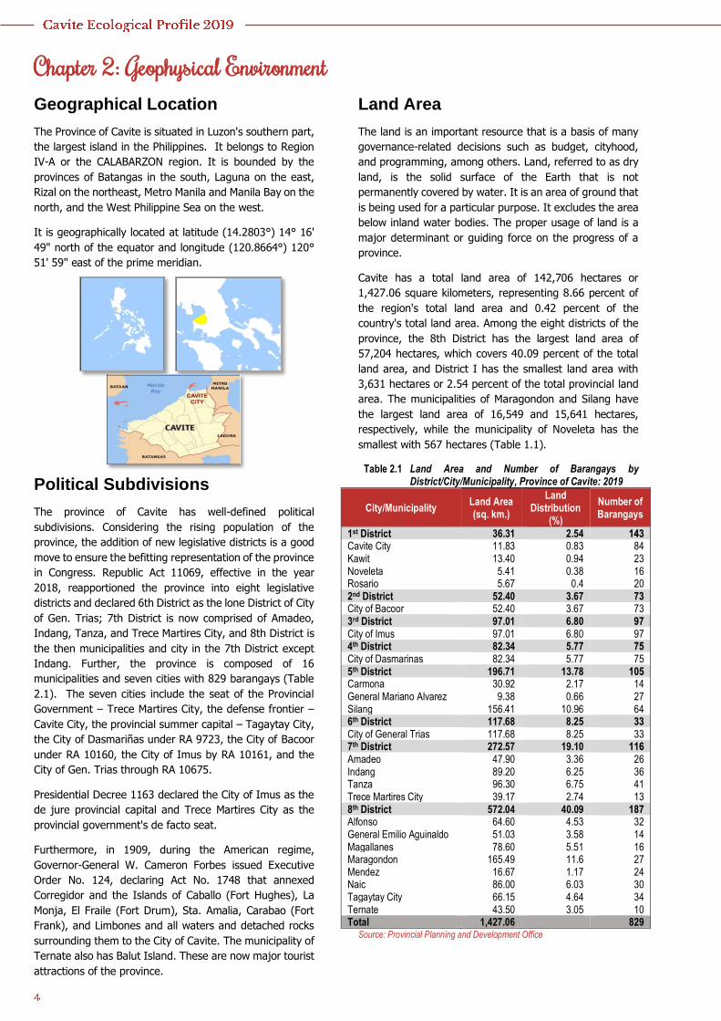
Chapter 2: Geophysical Environment Geographical Location
The Province of Cavite is situated in Luzon's southern part,
the largest island in the Philippines. It belongs to Region
IV-A or the CALABARZON region. It is bounded by the
provinces of Batangas in the south, Laguna on the east,
Rizal on the northeast, Metro Manila and Manila Bay on the
north, and the West Philippine Sea on the west.
It is geographically located at latitude (14.2803°) 14° 16'
49" north of the equator and longitude (120.8664°) 120°
51' 59" east of the prime meridian.
Political Subdivisions
The province of Cavite has well-defined political
subdivisions. Considering the rising population of the
province, the addition of new legislative districts is a good
move to ensure the befitting representation of the province
in Congress. Republic Act 11069, effective in the year
2018, reapportioned the province into eight legislative
districts and declared 6th District as the lone District of City
of Gen. Trias; 7th District is now comprised of Amadeo,
Indang, Tanza, and Trece Martires City, and 8th District is
the then municipalities and city in the 7th District except
Indang. Further, the province is composed of 16
municipalities and seven cities with 829 barangays (Table
2.1). The seven cities include the seat of the Provincial
Government – Trece Martires City, the defense frontier –
Cavite City, the provincial summer capital – Tagaytay City,
the City of Dasmariñas under RA 9723, the City of Bacoor
under RA 10160, the City of Imus by RA 10161, and the
City of Gen. Trias through RA 10675.
Presidential Decree 1163 declared the City of Imus as the
de jure provincial capital and Trece Martires City as the
provincial government's de facto seat.
Furthermore, in 1909, during the American regime,
Governor-General W. Cameron Forbes issued Executive
Order No. 124, declaring Act No. 1748 that annexed
Corregidor and the Islands of Caballo (Fort Hughes), La
Monja, El Fraile (Fort Drum), Sta. Amalia, Carabao (Fort
Frank), and Limbones and all waters and detached rocks
surrounding them to the City of Cavite. The municipality of
Ternate also has Balut Island. These are now major tourist
attractions of the province.
Land Area
The land is an important resource that is a basis of many
governance-related decisions such as budget, cityhood,
and programming, among others. Land, referred to as dry
land, is the solid surface of the Earth that is not
permanently covered by water. It is an area of ground that
is being used for a particular purpose. It excludes the area
below inland water bodies. The proper usage of land is a
major determinant or guiding force on the progress of a
province.
Cavite has a total land area of 142,706 hectares or
1,427.06 square kilometers, representing 8.66 percent of
the region's total land area and 0.42 percent of the
country's total land area. Among the eight districts of the
province, the 8th District has the largest land area of
57,204 hectares, which covers 40.09 percent of the total
land area, and District I has the smallest land area with
3,631 hectares or 2.54 percent of the total provincial land
area. The municipalities of Maragondon and Silang have
the largest land area of 16,549 and 15,641 hectares,
respectively, while the municipality of Noveleta has the
smallest with 567 hectares (Table 1.1).
Table 2.1 Land Area and Number of Barangays by District/City/Municipality, Province of Cavite: 2019
City/Municipality Land Area (sq. km.)
Land Distribution
(%)
Number of Barangays
1st District 36.31 2.54 143 Cavite City 11.83 0.83 84 Kawit 13.40 0.94 23 Noveleta 5.41 0.38 16 Rosario 5.67 0.4 20 2nd District 52.40 3.67 73 City of Bacoor 52.40 3.67 73 3rd District 97.01 6.80 97 City of Imus 97.01 6.80 97 4th District 82.34 5.77 75 City of Dasmarinas 82.34 5.77 75 5th District 196.71 13.78 105 Carmona 30.92 2.17 14 General Mariano Alvarez 9.38 0.66 27 Silang 156.41 10.96 64 6th District 117.68 8.25 33 City of General Trias 117.68 8.25 33 7th District 272.57 19.10 116 Amadeo 47.90 3.36 26 Indang 89.20 6.25 36 Tanza 96.30 6.75 41 Trece Martires City 39.17 2.74 13 8th District 572.04 40.09 187 Alfonso 64.60 4.53 32 General Emilio Aguinaldo 51.03 3.58 14 Magallanes 78.60 5.51 16 Maragondon 165.49 11.6 27 Mendez 16.67 1.17 24 Naic 86.00 6.03 30 Tagaytay City 66.15 4.64 34 Ternate 43.50 3.05 10 Total 1,427.06 829
Source: Provincial Planning and Development Office
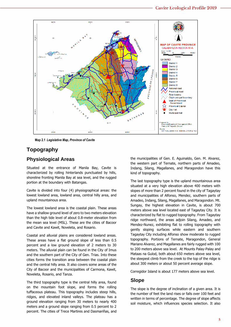
Map 2.1 Legislative Map, Province of Cavite
Topography
Physiological Areas
Situated at the entrance of Manila Bay, Cavite is
characterized by rolling hinterlands punctuated by hills,
shoreline fronting Manila Bay at sea level, and the rugged
portion at the boundary with Batangas.
Cavite is divided into four (4) physiographical areas: the
lowest lowland area, lowland area, central hilly area, and
upland mountainous area.
The lowest lowland area is the coastal plain. These areas
have a shallow ground level of zero to two meters elevation
than the high tide level of about 0.8-meter elevation from
the mean sea level (MSL). These are the cities of Bacoor
and Cavite and Kawit, Noveleta, and Rosario.
Coastal and alluvial plains are considered lowland areas.
These areas have a flat ground slope of less than 0.5
percent and a low ground elevation of 2 meters to 30
meters. The alluvial plain can be found in the City of Imus
and the southern part of the City of Gen. Trias. Into these
cities forms the transition area between the coastal plain
and the central hilly area. It also covers some areas of the
City of Bacoor and the municipalities of Carmona, Kawit,
Noveleta, Rosario, and Tanza.
The third topography type is the central hilly area, found
on the mountain foot slope, and forms the rolling
tuffaceous plateau. This topography includes steep hills,
ridges, and elevated inland valleys. The plateau has a
ground elevation ranging from 30 meters to nearly 400
meters and a ground slope ranging from 0.5 percent to 2
percent. The cities of Trece Martires and Dasmariñas, and
the municipalities of Gen. E. Aguinaldo, Gen. M. Alvarez,
the western part of Ternate, northern parts of Amadeo,
Indang, Silang, Magallanes, and Maragondon have this
kind of topography.
The last topography type is the upland mountainous area
situated at a very high elevation above 400 meters with
slopes of more than 2 percent found in the city of Tagaytay
and municipalities of Alfonso, Mendez, southern parts of
Amadeo, Indang, Silang, Magallanes, and Maragondon. Mt.
Sungay, the highest elevation in Cavite, is about 700
meters above sea level located east of Tagaytay City. It is
characterized by flat to rugged topography. From Tagaytay
ridge northward, the areas adjoin Silang, Amadeo, and
Mendez-Nunez, exhibiting flat to rolling topography with
gently sloping surfaces while eastern and southern
Tagaytay City including Alfonso show moderate to rugged
topography. Portions of Ternate, Maragondon, General
Mariano Alvarez, and Magallanes are fairly rugged with 100
to 200 meters above sea level. At Mounts Palay-Palay and
Mataas na Gulod, both about 650 meters above sea level,
the steepest climb from the creek to the top of the ridge is
about 300 meters or about 50 percent average slope.
Corregidor Island is about 177 meters above sea level.
Slope
The slope is the degree of inclination of a given area. It is
the number of feet the land rises or falls over 100 feet and
written in terms of percentage. The degree of slope affects
soil moisture, which influences species selection. It also
estimates the erosion potential of the place and helps in
selecting the most appropriate planting techniques.
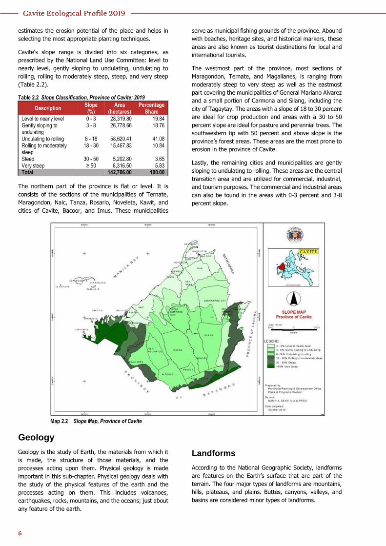
Cavite's slope range is divided into six categories, as
prescribed by the National Land Use Committee: level to
nearly level, gently sloping to undulating, undulating to
rolling, rolling to moderately steep, steep, and very steep
(Table 2.2).
Table 2.2 Slope Classification, Province of Cavite: 2019
Description Slope
(%) Area
(hectares) Percentage
Share
Level to nearly level 0 - 3 28,319.80 19.84 Gently sloping to undulating
3 - 8 26,778.66 18.76
Undulating to rolling 8 - 18 58,620.41 41.08 Rolling to moderately steep
18 - 30 15,467.83 10.84
Steep 30 - 50 5,202.80 3.65 Very steep ≥ 50 8,316.50 5.83 Total
142,706.00 100.00
The northern part of the province is flat or level. It is
consists of the sections of the municipalities of Ternate,
Maragondon, Naic, Tanza, Rosario, Noveleta, Kawit, and
cities of Cavite, Bacoor, and Imus. These municipalities
serve as municipal fishing grounds of the province. Abound
with beaches, heritage sites, and historical markers, these
areas are also known as tourist destinations for local and
international tourists.
The westmost part of the province, most sections of
Maragondon, Ternate, and Magallanes, is ranging from
moderately steep to very steep as well as the eastmost
part covering the municipalities of General Mariano Alvarez
and a small portion of Carmona and Silang, including the
city of Tagaytay. The areas with a slope of 18 to 30 percent
are ideal for crop production and areas with a 30 to 50
percent slope are ideal for pasture and perennial trees. The
southwestern tip with 50 percent and above slope is the
province’s forest areas. These areas are the most prone to
erosion in the province of Cavite.
Lastly, the remaining cities and municipalities are gently
sloping to undulating to rolling. These areas are the central
transition area and are utilized for commercial, industrial,
and tourism purposes. The commercial and industrial areas
can also be found in the areas with 0-3 percent and 3-8
percent slope.
Map 2.2 Slope Map, Province of Cavite
Geology
Geology is the study of Earth, the materials from which it
is made, the structure of those materials, and the
processes acting upon them. Physical geology is made
important in this sub-chapter. Physical geology deals with
the study of the physical features of the earth and the
processes acting on them. This includes volcanoes,
earthquakes, rocks, mountains, and the oceans; just about
any feature of the earth.
Landforms
According to the National Geographic Society, landforms
are features on the Earth’s surface that are part of the
terrain. The four major types of landforms are mountains,
hills, plateaus, and plains. Buttes, canyons, valleys, and
basins are considered minor types of landforms.
The Philippines, fondly called the “Pearl of the Orient
Seas”, has its diverse environment, well known for its
different landforms. Some of it can be found in the
province of Cavite.
The province of Cavite has its share in the mesmerizing
beauty of nature that every Filipinos can enjoy. Pico de
Loro, also known as the Parrot’s Beak, is one of the most
popular mountains in the Philippines. The wide plains of
Cavite, the West Philippine Sea, and the coves and beaches
of Nasugbu can be seen at the peak due to its elevation of
688 meters. Mt. Pico de Loro is part of the Mt. Palay-Palay-
Mataas-na-Gulod Protected Landscape, the remaining
lowland rainforest in Cavite, covering particularly
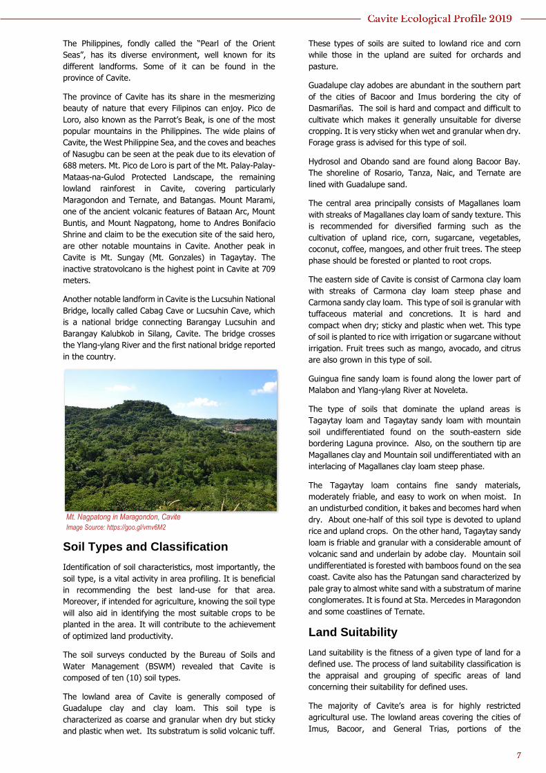
Maragondon and Ternate, and Batangas. Mount Marami,
one of the ancient volcanic features of Bataan Arc, Mount
Buntis, and Mount Nagpatong, home to Andres Bonifacio
Shrine and claim to be the execution site of the said hero,
are other notable mountains in Cavite. Another peak in
Cavite is Mt. Sungay (Mt. Gonzales) in Tagaytay. The
inactive stratovolcano is the highest point in Cavite at 709
meters.
Another notable landform in Cavite is the Lucsuhin National
Bridge, locally called Cabag Cave or Lucsuhin Cave, which
is a national bridge connecting Barangay Lucsuhin and
Barangay Kalubkob in Silang, Cavite. The bridge crosses
the Ylang-ylang River and the first national bridge reported
in the country.
Soil Types and Classification
Identification of soil characteristics, most importantly, the
soil type, is a vital activity in area profiling. It is beneficial
in recommending the best land-use for that area.
Moreover, if intended for agriculture, knowing the soil type
will also aid in identifying the most suitable crops to be
planted in the area. It will contribute to the achievement
of optimized land productivity.
The soil surveys conducted by the Bureau of Soils and
Water Management (BSWM) revealed that Cavite is
composed of ten (10) soil types.
The lowland area of Cavite is generally composed of
Guadalupe clay and clay loam. This soil type is
characterized as coarse and granular when dry but sticky
and plastic when wet. Its substratum is solid volcanic tuff.
These types of soils are suited to lowland rice and corn
while those in the upland are suited for orchards and
pasture.
Guadalupe clay adobes are abundant in the southern part
of the cities of Bacoor and Imus bordering the city of
Dasmariñas. The soil is hard and compact and difficult to
cultivate which makes it generally unsuitable for diverse
cropping. It is very sticky when wet and granular when dry.
Forage grass is advised for this type of soil.
Hydrosol and Obando sand are found along Bacoor Bay.
The shoreline of Rosario, Tanza, Naic, and Ternate are
lined with Guadalupe sand.
The central area principally consists of Magallanes loam
with streaks of Magallanes clay loam of sandy texture. This
is recommended for diversified farming such as the
cultivation of upland rice, corn, sugarcane, vegetables,
coconut, coffee, mangoes, and other fruit trees. The steep
phase should be forested or planted to root crops.
The eastern side of Cavite is consist of Carmona clay loam
with streaks of Carmona clay loam steep phase and
Carmona sandy clay loam. This type of soil is granular with
tuffaceous material and concretions. It is hard and
compact when dry; sticky and plastic when wet. This type
of soil is planted to rice with irrigation or sugarcane without
irrigation. Fruit trees such as mango, avocado, and citrus
are also grown in this type of soil.
Guingua fine sandy loam is found along the lower part of
Malabon and Ylang-ylang River at Noveleta.
The type of soils that dominate the upland areas is
Tagaytay loam and Tagaytay sandy loam with mountain
soil undifferentiated found on the south-eastern side
bordering Laguna province. Also, on the southern tip are
Magallanes clay and Mountain soil undifferentiated with an
interlacing of Magallanes clay loam steep phase.
The Tagaytay loam contains fine sandy materials,
moderately friable, and easy to work on when moist. In
an undisturbed condition, it bakes and becomes hard when
dry. About one-half of this soil type is devoted to upland
rice and upland crops. On the other hand, Tagaytay sandy
loam is friable and granular with a considerable amount of
volcanic sand and underlain by adobe clay. Mountain soil
undifferentiated is forested with bamboos found on the sea
coast. Cavite also has the Patungan sand characterized by
pale gray to almost white sand with a substratum of marine
conglomerates. It is found at Sta. Mercedes in Maragondon
and some coastlines of Ternate.
Land Suitability
Land suitability is the fitness of a given type of land for a
defined use. The process of land suitability classification is
the appraisal and grouping of specific areas of land
concerning their suitability for defined uses.
The majority of Cavite’s area is for highly restricted
agricultural use. The lowland areas covering the cities of
Imus, Bacoor, and General Trias, portions of the
Mt. Nagpatong in Maragondon, Cavite
Image Source: https://goo.gl/vmv6M2
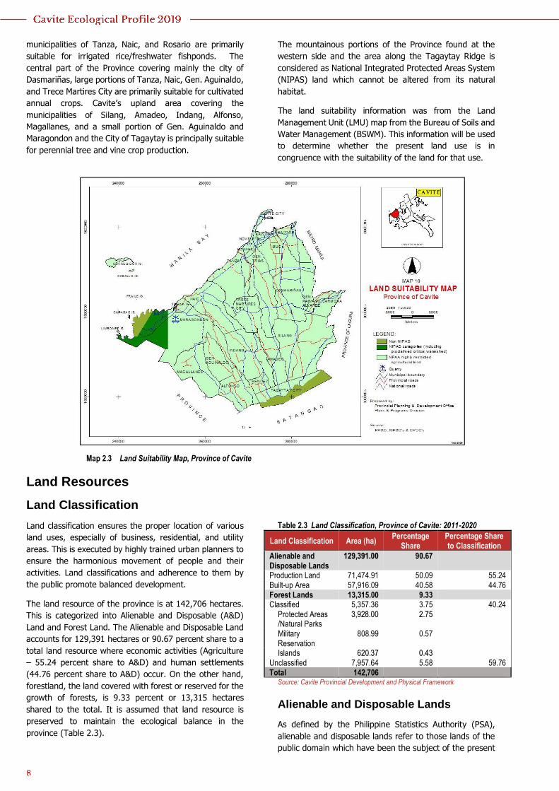
municipalities of Tanza, Naic, and Rosario are primarily
suitable for irrigated rice/freshwater fishponds. The
central part of the Province covering mainly the city of
Dasmariñas, large portions of Tanza, Naic, Gen. Aguinaldo,
and Trece Martires City are primarily suitable for cultivated
annual crops. Cavite’s upland area covering the
municipalities of Silang, Amadeo, Indang, Alfonso,
Magallanes, and a small portion of Gen. Aguinaldo and
Maragondon and the City of Tagaytay is principally suitable
for perennial tree and vine crop production.
The mountainous portions of the Province found at the
western side and the area along the Tagaytay Ridge is
considered as National Integrated Protected Areas System
(NIPAS) land which cannot be altered from its natural
habitat.
The land suitability information was from the Land
Management Unit (LMU) map from the Bureau of Soils and
Water Management (BSWM). This information will be used
to determine whether the present land use is in
congruence with the suitability of the land for that use.
Map 2.3 Land Suitability Map, Province of Cavite
Land Resources
Land Classification
Land classification ensures the proper location of various
land uses, especially of business, residential, and utility
areas. This is executed by highly trained urban planners to
ensure the harmonious movement of people and their
activities. Land classifications and adherence to them by
the public promote balanced development.
The land resource of the province is at 142,706 hectares.
This is categorized into Alienable and Disposable (A&D)
Land and Forest Land. The Alienable and Disposable Land
accounts for 129,391 hectares or 90.67 percent share to a
total land resource where economic activities (Agriculture
– 55.24 percent share to A&D) and human settlements
(44.76 percent share to A&D) occur. On the other hand,
forestland, the land covered with forest or reserved for the
growth of forests, is 9.33 percent or 13,315 hectares
shared to the total. It is assumed that land resource is
preserved to maintain the ecological balance in the
province (Table 2.3).
Table 2.3 Land Classification, Province of Cavite: 2011-2020
Land Classification Area (ha) Percentage
Share Percentage Share to Classification
Alienable and Disposable Lands
129,391.00 90.67
Production Land 71,474.91 50.09 55.24 Built-up Area 57,916.09 40.58 44.76 Forest Lands 13,315.00 9.33 Classified 5,357.36 3.75 40.24
Protected Areas /Natural Parks
3,928.00 2.75
Military Reservation
808.99 0.57
Islands 620.37 0.43 Unclassified 7,957.64 5.58 59.76 Total 142,706
Source: Cavite Provincial Development and Physical Framework
Alienable and Disposable Lands
As defined by the Philippine Statistics Authority (PSA),
alienable and disposable lands refer to those lands of the
public domain which have been the subject of the present
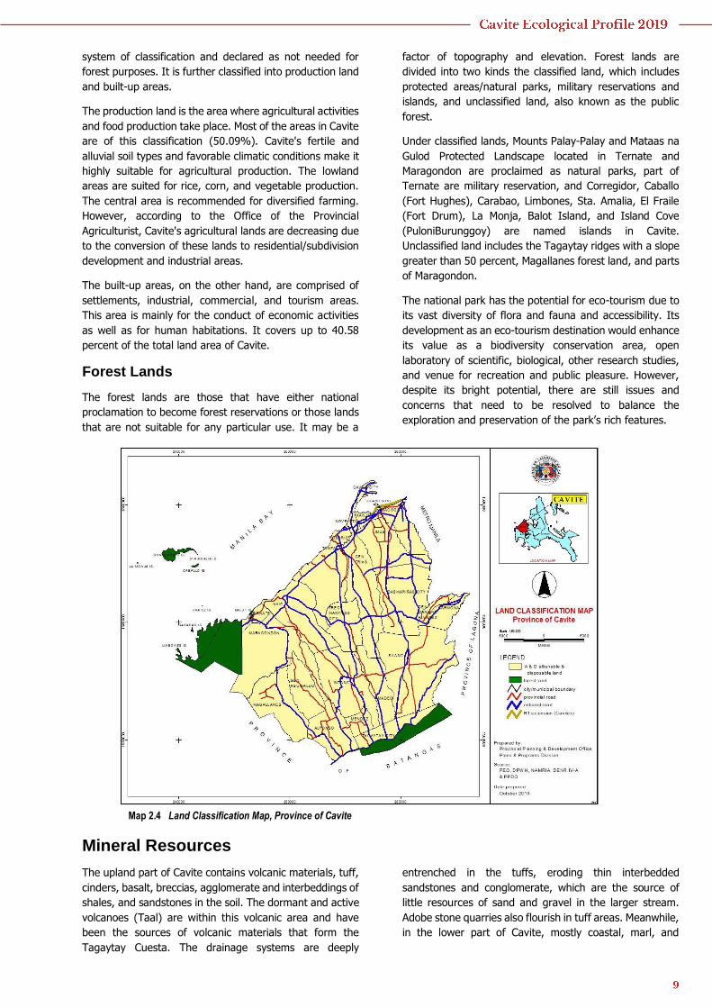
system of classification and declared as not needed for
forest purposes. It is further classified into production land
and built-up areas.
The production land is the area where agricultural activities
and food production take place. Most of the areas in Cavite
are of this classification (50.09%). Cavite's fertile and
alluvial soil types and favorable climatic conditions make it
highly suitable for agricultural production. The lowland
areas are suited for rice, corn, and vegetable production.
The central area is recommended for diversified farming.
However, according to the Office of the Provincial
Agriculturist, Cavite's agricultural lands are decreasing due
to the conversion of these lands to residential/subdivision
development and industrial areas.
The built-up areas, on the other hand, are comprised of
settlements, industrial, commercial, and tourism areas.
This area is mainly for the conduct of economic activities
as well as for human habitations. It covers up to 40.58
percent of the total land area of Cavite.
Forest Lands
The forest lands are those that have either national
proclamation to become forest reservations or those lands
that are not suitable for any particular use. It may be a
factor of topography and elevation. Forest lands are
divided into two kinds the classified land, which includes
protected areas/natural parks, military reservations and
islands, and unclassified land, also known as the public
forest.
Under classified lands, Mounts Palay-Palay and Mataas na
Gulod Protected Landscape located in Ternate and
Maragondon are proclaimed as natural parks, part of
Ternate are military reservation, and Corregidor, Caballo
(Fort Hughes), Carabao, Limbones, Sta. Amalia, El Fraile
(Fort Drum), La Monja, Balot Island, and Island Cove
(PuloniBurunggoy) are named islands in Cavite.
Unclassified land includes the Tagaytay ridges with a slope
greater than 50 percent, Magallanes forest land, and parts
of Maragondon.
The national park has the potential for eco-tourism due to
its vast diversity of flora and fauna and accessibility. Its
development as an eco-tourism destination would enhance
its value as a biodiversity conservation area, open
laboratory of scientific, biological, other research studies,
and venue for recreation and public pleasure. However,
despite its bright potential, there are still issues and
concerns that need to be resolved to balance the
exploration and preservation of the park’s rich features.
Map 2.4 Land Classification Map, Province of Cavite
Mineral Resources
The upland part of Cavite contains volcanic materials, tuff,
cinders, basalt, breccias, agglomerate and interbeddings of
shales, and sandstones in the soil. The dormant and active
volcanoes (Taal) are within this volcanic area and have
been the sources of volcanic materials that form the
Tagaytay Cuesta. The drainage systems are deeply
entrenched in the tuffs, eroding thin interbedded
sandstones and conglomerate, which are the source of
little resources of sand and gravel in the larger stream.
Adobe stone quarries also flourish in tuff areas. Meanwhile,
in the lower part of Cavite, mostly coastal, marl, and
conglomerate can be found. Igneous rocks are prominent
in the high, mountainous regions of western Cavite.
Specifically, the City of Bacoor and municipalities of
General Mariano Alvarez, Tanza and Ternate have andesite
and basalt; Cities of Dasmariñas and General Trias and
municipalities of Indang, Maragondon, and Naic have sand
and gravel; and Magallanes has clay.
Table 2.4 Mineral Resources, Province of Cavite: 2018
City/Municipality Mineral Resources City of Bacoor Andesite, Basalt City of Dasmariñas Sand and Gravel City of General Trias Sand and Gravel General Mariano Alvarez Andesite, Basalt Indang Sand and Gravel Magallanes Clay Maragondon Sand and Gravel Naic Sand and Gravel Tanza Andesite, Basalt Ternate Andesite, Basalt Source: CALABARZON Mining and Minerals Industry Profile – Mines and
Geosciences Bureau IV-A
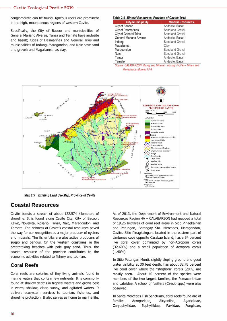
Map 2.5 Existing Land Use Map, Province of Cavite
Coastal Resources
Cavite boasts a stretch of about 122.574 kilometers of
shoreline. It is found along Cavite City, City of Bacoor,
Kawit, Noveleta, Rosario, Tanza, Naic, Maragondon, and
Ternate. The richness of Cavite’s coastal resources paved
the way for our recognition as a major producer of oysters
and mussels. The fisherfolks are also active producers of
sugpo and bangus. On the western coastlines lie the
breathtaking beaches with pale gray sand. Thus, the
coastal resource of the province contributes to the
economic activities related to fishery and tourism.
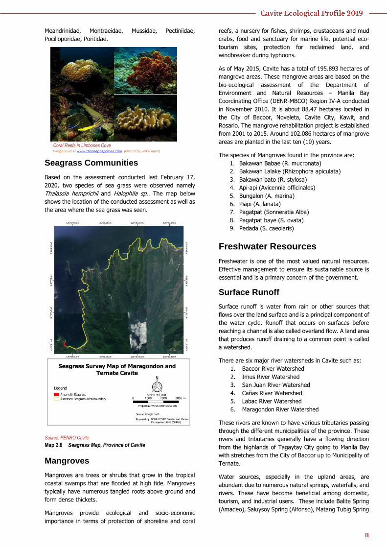
Coral Reefs
Coral reefs are colonies of tiny living animals found in
marine waters that contain few nutrients. It is commonly
found at shallow depths in tropical waters and grows best
in warm, shallow, clear, sunny, and agitated waters. It
delivers ecosystem services to tourism, fisheries, and
shoreline protection. It also serves as home to marine life.
As of 2013, the Department of Environment and Natural
Resources Region 4A – CALABARZON had mapped a total
of 19.26 hectares of coral reef areas in Sitio Pinagkainan
and Patungan, Barangay Sta. Mercedes, Maragondon,
Cavite. Sitio Pinagkaingan, located in the eastern part of
Limbones cove opposite Carabao Island, has a 34 percent
live coral cover dominated by non-Acropora corals
(32.60%) and a small population of Acropora corals
(1.40%).
In Sitio Patungan Munti, slightly sloping ground and good
water visibility at 30 feet depth, has about 32.76 percent
live coral cover where the “staghorn” corals (20%) are
mostly seen. About 40 percent of the species were
members of the two largest families, the Pomacentridae
and Labridae. A school of fusiliers (Caesio spp.) were also
observed.
In Santa Mercedes Fish Sanctuary, coral reefs found are of
families Acroporidae, Alcyoniina, Agariciidae,
Caryophyllidae, Euphylliidae, Paviidae, Fungiidae,
Meandrinidae, Montraeidae, Mussidae, Pectiniidae,
Pocilloporidae, Poritidae.
Seagrass Communities
Based on the assessment conducted last February 17,
2020, two species of sea grass were observed namely
Thalassia hemprichii and Halophila sp.. The map below
shows the location of the conducted assessment as well as
the area where the sea grass was seen.
Source: PENRO Cavite
Map 2.6 Seagrass Map, Province of Cavite
Mangroves
Mangroves are trees or shrubs that grow in the tropical
coastal swamps that are flooded at high tide. Mangroves
typically have numerous tangled roots above ground and
form dense thickets.
Mangroves provide ecological and socio-economic
importance in terms of protection of shoreline and coral
reefs, a nursery for fishes, shrimps, crustaceans and mud
crabs, food and sanctuary for marine life, potential eco-
tourism sites, protection for reclaimed land, and
windbreaker during typhoons.
As of May 2015, Cavite has a total of 195.893 hectares of
mangrove areas. These mangrove areas are based on the
bio-ecological assessment of the Department of
Environment and Natural Resources – Manila Bay
Coordinating Office (DENR-MBCO) Region IV-A conducted
in November 2010. It is about 88.47 hectares located in
the City of Bacoor, Noveleta, Cavite City, Kawit, and
Rosario. The mangrove rehabilitation project is established
from 2001 to 2015. Around 102.086 hectares of mangrove
areas are planted in the last ten (10) years.
The species of Mangroves found in the province are:
1. Bakawan Babae (R. mucronata)
2. Bakawan Lalake (Rhizophora apiculata)
3. Bakawan bato (R. stylosa)
4. Api-api (Avicennia officinales)
5. Bungalon (A. marina)
6. Piapi (A. lanata)
7. Pagatpat (Sonneratia Alba)
8. Pagatpat baye (S. ovata)
9. Pedada (S. caeolaris)
Freshwater Resources
Freshwater is one of the most valued natural resources.
Effective management to ensure its sustainable source is
essential and is a primary concern of the government.
Surface Runoff
Surface runoff is water from rain or other sources that
flows over the land surface and is a principal component of
the water cycle. Runoff that occurs on surfaces before
reaching a channel is also called overland flow. A land area
that produces runoff draining to a common point is called
a watershed.
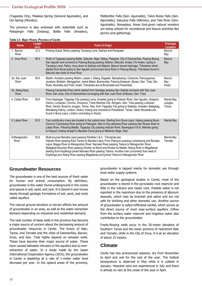
There are six major river watersheds in Cavite such as:
1. Bacoor River Watershed
2. Imus River Watershed
3. San Juan River Watershed
4. Cañas River Watershed
5. Labac River Watershed
6. Maragondon River Watershed
These rivers are known to have various tributaries passing
through the different municipalities of the province. These
rivers and tributaries generally have a flowing direction
from the highlands of Tagaytay City going to Manila Bay
with stretches from the City of Bacoor up to Municipality of
Ternate.
Water sources, especially in the upland areas, are
abundant due to numerous natural springs, waterfalls, and
rivers. These have become beneficial among domestic,
tourism, and industrial users. These include Balite Spring
(Amadeo), Saluysoy Spring (Alfonso), Matang Tubig Spring
Coral Reefs in Limbones Cove Image source: www.choosephilippines.com (Photos by: Mike Ajero)
(Tagaytay City), Malakas Spring (General Aguinaldo), and
Ulo Spring (Mendez).
The province is also endowed with waterfalls such as
Palsajingin Falls (Indang), Balite Falls (Amadeo),
Malibiclibic Falls (Gen. Aguinaldo), Talon-Butas Falls (Gen.
Aguinaldo), Saluysoy Falls (Alfonso), and Tala River (Gen.
Aguinaldo). Nowadays, these God-given natural wonders
are being utilized for recreational and leisure activities like
picnics and gatherings.
Table 2.5 Major Rivers, Province of Cavite
Name Length
(km) Point of Origin
Drainage Location
1. Bacoor River
12.3 Pintong Gubat, Molino passing Tanzang Luma, Salinas and Panapaan Bacoor Bay
2. Imus River 38.4 North of Tagaytay passing Balite, Sabutan, Biga, Silang, Palapala, City of Dasmariñas, Pasong Bayog, San Agustin and connects to Pasong Bayog passing Salitran, Baluctot, Anabu II & Anabu I going to Tanzang Luma, Palico, Imus down to Salinas and Mabolo, Bacoor toward drainage. Tributaries which started from Bucal going to San Agustin join/connect Imus River in Pasong Bayog. Tributaries found in Baluctot also drain at Imus River.
Bacoor Bay
3a. San Juan River
39.0
Maitim, Amadeo passing Maitim, Lalaan I, Silang, Dagatan, Banaybanay, Calubcob, Panungyanan, Javalera, Biclatan, Manggahan, Jaime Baker; Buenavista, Pasong Kawayan, Bacao, Gen. Trias; Sta. Rosa, Noveleta and Putol, Kawit. Tributaries are at Bucandala and Panamitan.
Bacoor Bay Kawit
3b. Alang-Ilang River
Pasong Camachile River which started from Santiago passing San Gabriel connects with San Juan River; San Jose, City of Dasmariñas converging with San Juan River at Bacao, Gen. Trias
4. Cañas River 38.9 From Kaybagal, Tagaytay City passing Loma, Amadeo going to Polanan River, San Agustin, Gregorio, Osorio, Lucbanan, Conchu, Inocencio, Trece Martires City; Alingaro, Gen. Trias passing Lubluban River, Santol, Bucal to Julugan, Tanza. Also, from Tagaytay City going to Salaban, Amadeo; Balagbag, Mahabang Kahoy, Limbon, Alulod, Indang and connects to Paradahan, Tanza. Other tributaries are found in Buna Lejos, Limbon connecting in Alulod.
Manila Bay Julugan, Tanza
5. Labac River 30.5
Two contributory rivers are located in the upland area. Starting from Buna Lejos, Indang passing Buna Cerca to Calumpang River going to Palangue, Naic to Kay-alamang River passing San Roque down to Labac River. Patutong Malaki, Tagaytay City passing Habulin River, Barangays II & III, Mendez going to Kayquit, Indang straight to Banaba Cerca going to Malainen Bago, Naic
Manila Bay
6.Maragondon River
35.6
Multi-sources Banaba Lejos passing Pantihan I & II. Tributaries are: Habulin River passing East Tambo to Banaba Lejos; From Palocpoc passing Lumampong and Banaba Lejos; Magay River to Maragondon River; Narvaez River passing Tabora to Maragondon River; Matagbak Buruhan River passing Sinaliw na Munti and Sinaliw na Malaki; Aliang River in Magallanes starting from Kaytitinga joined Narvaez River passing Tabora. Another river (unnamed) from west of Kaytitinga and Aliang River passing Magallanes and joined Tabora to Maragondon River
Manila Bay Ternate
Groundwater Resources
The groundwater is one of the best sources of fresh water
for human and animal consumption. By definition,
groundwater is the water found underground in the cracks
and spaces in soil, sand, and rock. It is stored in and moves
slowly through geologic formations of soil, sand, and rocks
called aquifers.
The natural ground elevation or terrain affects the amount
of groundwater in an area, as well as the water extraction
demand depending on industrial and residential demand.
The vast number of deep wells in the province has become
a major source of concern about the decreasing amount of
groundwater resources in Cavite. The towns of Naic,
Tanza, and Ternate and the cities of Dasmariñas, Bacoor,
Imus, and Gen. Trias highly depend on artesian wells.
These have become their major source of water. These
have caused saltwater intrusion in the aquifers due to over-
extraction of water. In a study made by the Japan
International Cooperation Agency (JICA), the groundwater
in Cavite is depleting at a rate of 1-meter water level
decrease per year. In the upland areas of the province,
groundwater is tapped mainly for domestic use through
local water supply systems.
Based on the geological studies in Cavite, most of the
groundwater is stored in the pyroclastic rock reservoir and
little in the volcano and clastic rock. Potable water is not
reported in the nearshore due to the presence of alluvium
deposits, which may be brackish and saline and are not
safe for drinking and other domestic use. Another source
of groundwater is called infiltrated rainfall, which serves as
the direct source of most near-surface aquifers. Inflow
from the surface water reservoir and irrigation water also
contributes to the groundwater.
Freely-flowing wells occur in the 30-meter elevation of
Southern Tanza and the lower portions of nearshore Naic
and Ternate, while in the City of Imus, it is at an elevation
of about 15 meters.
Climate
Cavite has two pronounced seasons, dry from November
to April and wet for the rest of the year. The hottest
temperature is observed in May while it is coldest in
January. Heaviest rains are experienced in July and there
is almost no rain at the onset of the year in April.
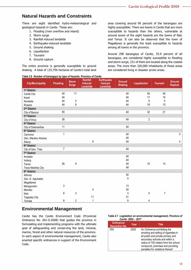
Natural Hazards and Constraints
There are eight identified hydro-meteorological and
geological hazards in Cavite. These are:
1. Flooding (river overflow and inland)
2. Storm surge
3. Rainfall induced landslide
4. Earthquake-induced landslide
5. Ground shaking
6. Liquefaction
7. Tsunami
8. Ground rupture
The entire province is generally susceptible to ground
shaking. A total of 125,756 hectares of Cavite’s total land
area covering around 90 percent of the barangays are
highly susceptible. There are towns in Cavite that are more
susceptible to hazards than the others, vulnerable at
around seven of the eight hazards are the towns of Naic
and Tanza. It can also be observed that the town of
Magallanes is generally the least susceptible to hazards
among all towns in the province.
Around 298 barangays of Cavite, 35.9 percent of all
barangays, are considered highly susceptible to flooding
and storm surge, 231 of them are located along the coastal
areas. The more than 320,000 inhabitants of those areas
are considered living in disaster prone areas.
Table 2.6 Number of barangays by type of hazards, Province of Cavite
City/Municipality Flooding Storm Surge
Rainfall Induced
Landslide
Earthquake Induced
Landslide
Ground Shaking
Liquefaction Tsunami Ground Rupture
1st District
Cavite City All 11 All All All
Kawit All All 17 16
Noveleta All 5 All 9 5
Rosario All 8 All 18 10
2nd District
City of Bacoor 55 All 32 21
3rd District
City of Imus 38 All 2
4th District
City of Dasmariñas 11 All
5th District
Carmona 1 All 3
Gen. Mariano Alvarez All
Silang 6 All 4
6th District
City of Gen. Trias 7 All
7th District
Amadeo All
Indang All
Tanza 26 9 All 10 14
Trece Martires City All
8th District
Alfonso 30
Gen. E. Aguinaldo 5
Magallanes
Maragondon 3 13
Mendez 4 All
Naic 8 3 3 5 7
Tagaytay City 11 31
Ternate 8 2 1 9 4
Environmental Management
Cavite has the Cavite Environment Code (Provincial
Ordinance No. 001-S-2008) that guides the province in
formulating and implementing programs with the ultimate
goal of safeguarding and conserving the land, mineral,
marine, forest and other natural resources of the province.
In each aspect of environmental management, Cavite also
enacted specific ordinances in support of the Environment
Code.
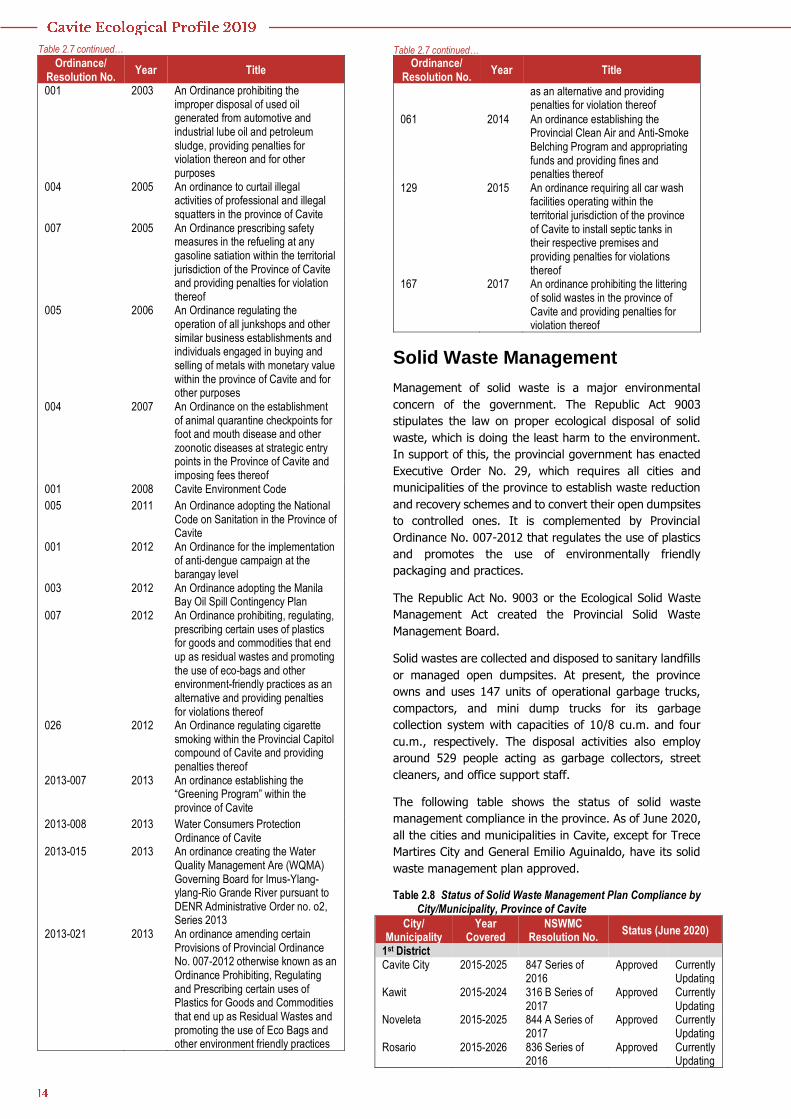
Table 2.7 Legislation on environmental management, Province of Cavite: 2002 – 2017
Ordinance/ Resolution No.
Year Title
004 2002 An Ordinance prohibiting the smoking and selling of cigarettes in all public and private primary and secondary schools and within a radius of 100 meters from the school compound, premises and providing penalties for violations thereof
Ordinance/ Resolution No.
Year Title
001 2003 An Ordinance prohibiting the improper disposal of used oil generated from automotive and industrial lube oil and petroleum sludge, providing penalties for violation thereon and for other purposes
004 2005 An ordinance to curtail illegal activities of professional and illegal squatters in the province of Cavite
007 2005 An Ordinance prescribing safety measures in the refueling at any gasoline satiation within the territorial jurisdiction of the Province of Cavite and providing penalties for violation thereof
005 2006 An Ordinance regulating the operation of all junkshops and other similar business establishments and individuals engaged in buying and selling of metals with monetary value within the province of Cavite and for other purposes
004 2007 An Ordinance on the establishment of animal quarantine checkpoints for foot and mouth disease and other zoonotic diseases at strategic entry points in the Province of Cavite and imposing fees thereof
001 2008 Cavite Environment Code
005 2011 An Ordinance adopting the National Code on Sanitation in the Province of Cavite
001 2012 An Ordinance for the implementation of anti-dengue campaign at the barangay level
003 2012 An Ordinance adopting the Manila Bay Oil Spill Contingency Plan
007 2012 An Ordinance prohibiting, regulating, prescribing certain uses of plastics for goods and commodities that end up as residual wastes and promoting the use of eco-bags and other environment-friendly practices as an alternative and providing penalties for violations thereof
026 2012 An Ordinance regulating cigarette smoking within the Provincial Capitol compound of Cavite and providing penalties thereof
2013-007 2013 An ordinance establishing the “Greening Program” within the province of Cavite
2013-008 2013 Water Consumers Protection Ordinance of Cavite
2013-015 2013 An ordinance creating the Water Quality Management Are (WQMA) Governing Board for Imus-Ylang-ylang-Rio Grande River pursuant to DENR Administrative Order no. o2, Series 2013
2013-021 2013 An ordinance amending certain Provisions of Provincial Ordinance No. 007-2012 otherwise known as an Ordinance Prohibiting, Regulating and Prescribing certain uses of Plastics for Goods and Commodities that end up as Residual Wastes and promoting the use of Eco Bags and other environment friendly practices
Ordinance/ Resolution No.
Year Title
as an alternative and providing penalties for violation thereof
061 2014 An ordinance establishing the Provincial Clean Air and Anti-Smoke Belching Program and appropriating funds and providing fines and penalties thereof
129 2015 An ordinance requiring all car wash facilities operating within the territorial jurisdiction of the province of Cavite to install septic tanks in their respective premises and providing penalties for violations thereof
167 2017 An ordinance prohibiting the littering of solid wastes in the province of Cavite and providing penalties for violation thereof
Solid Waste Management
Management of solid waste is a major environmental
concern of the government. The Republic Act 9003
stipulates the law on proper ecological disposal of solid
waste, which is doing the least harm to the environment.
In support of this, the provincial government has enacted
Executive Order No. 29, which requires all cities and
municipalities of the province to establish waste reduction
and recovery schemes and to convert their open dumpsites
to controlled ones. It is complemented by Provincial
Ordinance No. 007-2012 that regulates the use of plastics
and promotes the use of environmentally friendly
packaging and practices.
The Republic Act No. 9003 or the Ecological Solid Waste
Management Act created the Provincial Solid Waste
Management Board.
Solid wastes are collected and disposed to sanitary landfills
or managed open dumpsites. At present, the province
owns and uses 147 units of operational garbage trucks,
compactors, and mini dump trucks for its garbage
collection system with capacities of 10/8 cu.m. and four
cu.m., respectively. The disposal activities also employ
around 529 people acting as garbage collectors, street
cleaners, and office support staff.
The following table shows the status of solid waste
management compliance in the province. As of June 2020,
all the cities and municipalities in Cavite, except for Trece
Martires City and General Emilio Aguinaldo, have its solid
waste management plan approved.
Table 2.8 Status of Solid Waste Management Plan Compliance by City/Municipality, Province of Cavite
City/ Municipality
Year Covered
NSWMC Resolution No.
Status (June 2020)
1st District Cavite City 2015-2025 847 Series of
2016 Approved Currently
Updating Kawit 2015-2024 316 B Series of
2017 Approved Currently
Updating Noveleta 2015-2025 844 A Series of
2017 Approved Currently
Updating Rosario 2015-2026 836 Series of
2016 Approved Currently
Updating
Table 2.7 continued… Table 2.7 continued…
City/ Municipality
Year Covered
NSWMC Resolution No.
Status (June 2020)
2nd District City of Bacoor 2014-2023 111 Series of
2014 Approved Currently
Updating 3rd District City of Imus 2015-2024 692 B Series of
2017 Approved Currently
Updating 4th District City of Dasmariñas
2015-2025 538 A Series of 2016
Approved Currently Updating
5th District Carmona 2018-2027 182 Series of
2015 Approved Updated
Gen. Mariano Alvarez
2019-2028 846 Series of 2016
Approved Updated
Silang 2015-2025 837 Series of 2016
Approved Currently Updating
6th District City of Gen. Trias
2015-2024 833 Series of 2016
Approved Currently Updating
7th District Trece Martires City
2019-2028 N/A Submitted (Under Review -NSWMC)
Currently Updating
Indang 2016-2025 834 Series of 2016
Approved Currently Updating
Tanza 2015-2025 838 Series of 2016
Approved Currently Updating
Amadeo 2017-2026 537 B Series of 2017
Approved Currently Updating
City/ Municipality
Year Covered
NSWMC Resolution No.
Status (June 2020)
8th District Alfonso 2015-2025 845 B Series of
2017 Approved Currently
Updating Gen. E. Aguinaldo
Magallanes 2015-2024 314 B Series of 2017
Approved Currently Updating
Maragondon 2015-2024 835 Series of 2016
Approved Currently Updating
Mendez 2016-2025 722 B Series of 2017
Approved Currently Updating
Naic 2016-2025 840 A Series of 2017
Approved Currently Updating
Tagaytay City 2016-2025 848 A Series of 2017
Approved Currently Updating
Ternate 2015-2025 843 Series of 2016
Approved Currently Updating
Source: Provincial Government-Environment and Natural Resources Office
Cavite
The next table shows the projected daily waste generation,
solid waste disposal system, waste disposal equipment,
and frequency of garbage collection in the province of
Cavite. The solid waste disposal system in Cavite is by
contract or sanitary landfill. All cities and municipalities in
the province also have their centralized material recovery
facilities (MRF).
Table 2.9 Solid Waste Management by City/Municipality, Province of Cavite: 2019
City/Municipality
Projected Waste
Generationa (kg/day)
Waste Disposal Equipment
Frequency of Garbage Collection
Solid Waste Disposal Locationb Compactors
Big Garbage Trucks
Small Garbage Trucks
1st District Cavite City 48,141.53 1 1 Main Roads/Market – Daily
City Streets – twice a week San Mateo, Rizal
Kawit 42,824.94 1 3 Daily Suri Waste Management and Disposal Services, Calamba City, Laguna
Noveleta 16,493.84 3 0 Daily Navotas Sanitary Landfill Rosario 36,202.01 0 5 Daily Suri Waste Management and
Disposal Services, Calamba City 2nd District City of Bacoor 36,3548.2 Daily (by the contractor) Rizal Provincial Sanitary Landfill
and San Mateo Sanitary Landfill 3rd District City of Imus 183,383.9 3 0 Barangay – Once a week
Market – Daily Rizal
4th District City of Dasmarinas 231,673.7 8 12 3 Daily Brgy. Salawag, Dasmariñas City 5th District Carmona 38,579.79 3 10 Twice a week San Pedro, Laguna General M. Alvarez 60,323.45 Thrice a week Calamba City, Laguna Silang 136,452.3 5 1 7 Once a Week
Public market - Daily Bauan, Batangas
6th District City of General Trias 126,910.1 2 16 Twice a week Calamba City, Laguna 7th District Amadeo 16,086.22 1 0 Thrice a week Sta, Cruz, Laguna Indang 32,302.4 4 0 Daily (except Saturday) SB Hain, Calamba City, Laguna Tanza 88,903.93 6 18 Twice a Week Pilotage Sanitary Landfill, San
Pedro, Laguna Trece Martires City 74,265.62 2 3 0 Daily San Pedro, Laguna 8th District Alfonso 26,763.91 1 1 Twice a week Brgy. Piña, Taysan, Batangas General E. Aguinaldo 11,315.37 1 1 10 trips / week Sta. Cruz, Laguna Magallanes 10,256.66 1 0 Twice a week Bauan and Taysan, Batangas
Table 2.8 continued… Table 2.8 continued…
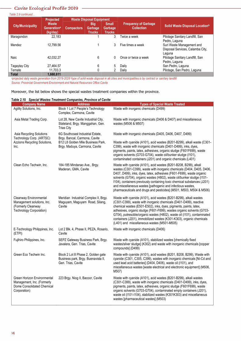
City/Municipality
Projected Waste
Generationa (kg/day)
Waste Disposal Equipment
Frequency of Garbage Collection
Solid Waste Disposal Locationb Compactors
Big Garbage Trucks
Small Garbage Trucks
Maragondon 22,183 1 3 Twice a week Pilotage Sanitary Landfill, San Pedro, Laguna
Mendez 12,799.56 1 3 Five times a week Suri Waste Management and Disposal Services, Calamba City, Laguna
Naic 42,032.27 6 0 Once or twice a week Pilotage Sanitary Landfill, San Pedro, Laguna
Tagaytay City 27,464.57 6 5 Daily San Pedro, Laguna Ternate 11,703.3 0 2 Daily Pilotage, San Pedro, Laguna Total 1,660,611 aprojected daily waste generation from 2019-2028 btype of solid waste disposal in all cities and municipalities is by contract or sanitary landfill
Source: Provincial Government-Environment and Natural Resources Office Cavite
Moreover, the list below shows the special wastes treatment companies within the province.
Table 2.10 Special Wastes Treatment Companies, Province of Cavite
Company Name Address Types of Special Waste Treated
Agility Solutions, Inc. Block 1 Lot 7 People’s Technology Complex, Carmona, Cavite
Waste with inorganic chemicals (D499)
Asia Metal Trading Corp. Lot 28, New Cavite Industrial City, Stateland, Brgy. Manggahan, Gen. Trias City
Waste with inorganic chemicals (D406 & D407) and miscellaneous wastes (M506 & M507)
Asia Recycling Solutions Technology Corp. (ARTSC)
6G Southcoast Industrial Estate, Brgy. Bancal, Carmona, Cavite
Waste with inorganic chemicals (D405, D406, D407, D499)
Azzions Recycling Solutions, Inc.
B12 L8 Golden Mile Business Park, Brgy. Maduya, Carmona, Cavite
Waste with cyanide (A101), acid wastes (B201-B299), alkali waste (C301-C399), waste with inorganic chemicals (D401-D499), inks, dyes, pigments, paints, latex, adhesives, organic sludge (F601F699), waste organic solvents (G703-G704), waste oil/bunker sludge (I101), contaminated containers (J201) and organic chemicals (L401)
Clean Echo Techwin, Inc. 184-185 Mindanao Ave., Brgy. Maderan, GMA, Cavite
Waste with cyanide (A101), acid wastes (B201-B208, B299), alkali wastes (C301-C399), waste with inorganic chemicals (D404, D405, D406, D407, D499), inks, dyes, latex, adhesives (F601-F699), waste organic solvents (G704), organic wastes (H802), waste oil/bunker sludge (I101-I104), containers previously containing toxic chemical substances (J201) and miscellaneous wastes [pathogenic and infectious wastes, pharmaceuticals and drugs and pesticides] (M501, M503, M504 & M506)
Cleanway Environmental Management solutions, Inc. (Formerly Cleanway Technology Corporation)
Meridian Industrial Complex II, Brgy. Maguyam, Maguyam Road, Silang, Cavite
Waste with cyanide (A101), acid wastes (B201-B299), alkali wastes (C301-C399), waste with inorganic chemicals (D401-D499), reactive chemical wastes (E501-E502), inks, dyes, pigments, paints, latex, adhesives, organic sludge (F601-F699), wastes organic solvents (G703-G704), putrescible/organic wastes (H802), waste oil (I101), contaminated containers (J201), immobilized wastes (K301-K303), organic chemicals (L401) and miscellaneous wastes (M501-M505)
E-Technology Philippines, Inc. (ETPI)
Lot 2 Blk. 4, Phase II, PEZA, Rosario, Cavite
Waste with inorganic chemicals (D406)
Fujihiro Philippines, Inc. SEPZ Gateway Business Park, Brgy. Javalera, Gen. Trias, Cavite
Waste with cyanide (A101), stabilized wastes [chemically fixed wastes/silver sludge] (K302) and waste with inorganic chemicals [copper compounds] (D499)
Green Eco Techwin Inc. Block 2 Lot 8 Phase 2, Golden gate Business park, Brgy. Buenavista II, Gen. Trias, Cavite
Waste with cyanide (A101), acid wastes (B201, B208, B299), Waste with cyanide (C301, C305, C399), wastes with inorganic chemicals [Ni-Cd and used lead acid batteries] (D404, D406), waste oil (I101), and miscellaneous wastes [waste electrical and electronic equipment] (M506, M507)
Green Horizon Environmental Management, Inc. (Formerly Dome Consolidated Chemical Corporation)
223 Brgy. Niog II, Bacoor, Cavite Waste with cyanide (A101), acid wastes (B201-B299), alkali wastes (C301-C399), waste with inorganic chemicals (D401-D499), inks, dyes, pigments, paints, latex, adhesives, organic sludge (F601F699), waste organic solvents (G703-G704), contaminated empty containers (J201), waste oil (I101-I104), stabilized wastes (K301K303) and miscellaneous wastes [pharmaceutical wastes] (M503)
Table 2.9 continued…
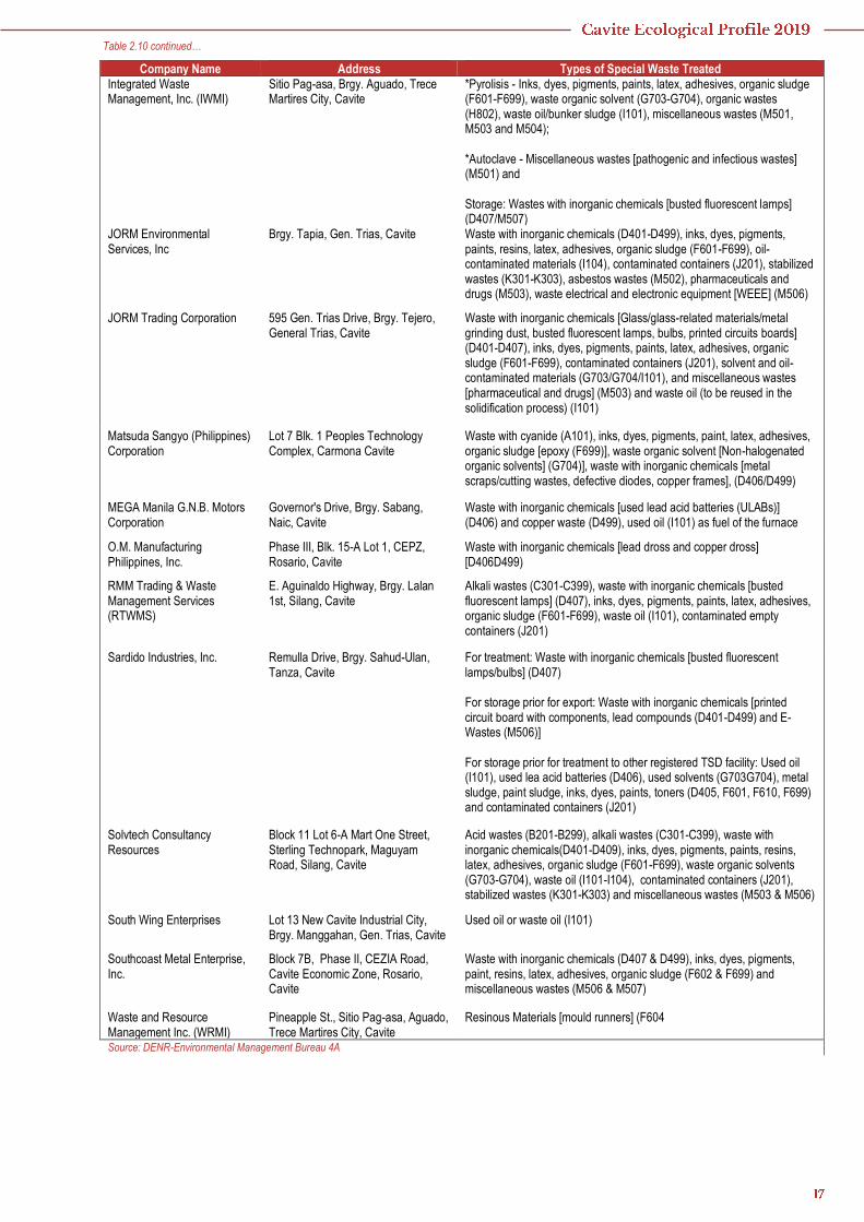
Company Name Address Types of Special Waste Treated Integrated Waste Management, Inc. (IWMI)
Sitio Pag-asa, Brgy. Aguado, Trece Martires City, Cavite
*Pyrolisis - Inks, dyes, pigments, paints, latex, adhesives, organic sludge (F601-F699), waste organic solvent (G703-G704), organic wastes (H802), waste oil/bunker sludge (I101), miscellaneous wastes (M501, M503 and M504); *Autoclave - Miscellaneous wastes [pathogenic and infectious wastes] (M501) and Storage: Wastes with inorganic chemicals [busted fluorescent lamps] (D407/M507)
JORM Environmental Services, Inc
Brgy. Tapia, Gen. Trias, Cavite Waste with inorganic chemicals (D401-D499), inks, dyes, pigments, paints, resins, latex, adhesives, organic sludge (F601-F699), oil-contaminated materials (I104), contaminated containers (J201), stabilized wastes (K301-K303), asbestos wastes (M502), pharmaceuticals and drugs (M503), waste electrical and electronic equipment [WEEE] (M506)
JORM Trading Corporation 595 Gen. Trias Drive, Brgy. Tejero, General Trias, Cavite
Waste with inorganic chemicals [Glass/glass-related materials/metal grinding dust, busted fluorescent lamps, bulbs, printed circuits boards] (D401-D407), inks, dyes, pigments, paints, latex, adhesives, organic sludge (F601-F699), contaminated containers (J201), solvent and oil-contaminated materials (G703/G704/I101), and miscellaneous wastes [pharmaceutical and drugs] (M503) and waste oil (to be reused in the solidification process) (I101)
Matsuda Sangyo (Philippines) Corporation
Lot 7 Blk. 1 Peoples Technology Complex, Carmona Cavite
Waste with cyanide (A101), inks, dyes, pigments, paint, latex, adhesives, organic sludge [epoxy (F699)], waste organic solvent [Non-halogenated organic solvents] (G704)], waste with inorganic chemicals [metal scraps/cutting wastes, defective diodes, copper frames], (D406/D499)
MEGA Manila G.N.B. Motors Corporation
Governor's Drive, Brgy. Sabang, Naic, Cavite
Waste with inorganic chemicals [used lead acid batteries (ULABs)] (D406) and copper waste (D499), used oil (I101) as fuel of the furnace
O.M. Manufacturing Philippines, Inc.
Phase III, Blk. 15-A Lot 1, CEPZ, Rosario, Cavite
Waste with inorganic chemicals [lead dross and copper dross] [D406D499)
RMM Trading & Waste Management Services (RTWMS)
E. Aguinaldo Highway, Brgy. Lalan 1st, Silang, Cavite
Alkali wastes (C301-C399), waste with inorganic chemicals [busted fluorescent lamps] (D407), inks, dyes, pigments, paints, latex, adhesives, organic sludge (F601-F699), waste oil (I101), contaminated empty containers (J201)
Sardido Industries, Inc. Remulla Drive, Brgy. Sahud-Ulan, Tanza, Cavite
For treatment: Waste with inorganic chemicals [busted fluorescent lamps/bulbs] (D407) For storage prior for export: Waste with inorganic chemicals [printed circuit board with components, lead compounds (D401-D499) and E-Wastes (M506)] For storage prior for treatment to other registered TSD facility: Used oil (I101), used lea acid batteries (D406), used solvents (G703G704), metal sludge, paint sludge, inks, dyes, paints, toners (D405, F601, F610, F699) and contaminated containers (J201)
Solvtech Consultancy Resources
Block 11 Lot 6-A Mart One Street, Sterling Technopark, Maguyam Road, Silang, Cavite
Acid wastes (B201-B299), alkali wastes (C301-C399), waste with inorganic chemicals(D401-D409), inks, dyes, pigments, paints, resins, latex, adhesives, organic sludge (F601-F699), waste organic solvents (G703-G704), waste oil (I101-I104), contaminated containers (J201), stabilized wastes (K301-K303) and miscellaneous wastes (M503 & M506)
South Wing Enterprises Lot 13 New Cavite Industrial City, Brgy. Manggahan, Gen. Trias, Cavite
Used oil or waste oil (I101)
Southcoast Metal Enterprise, Inc.
Block 7B, Phase II, CEZIA Road, Cavite Economic Zone, Rosario, Cavite
Waste with inorganic chemicals (D407 & D499), inks, dyes, pigments, paint, resins, latex, adhesives, organic sludge (F602 & F699) and miscellaneous wastes (M506 & M507)
Waste and Resource Management Inc. (WRMI)
Pineapple St., Sitio Pag-asa, Aguado, Trece Martires City, Cavite
Resinous Materials [mould runners] (F604
Source: DENR-Environmental Management Bureau 4A
Table 2.10 continued…