chapter 2 natural and socio-economic conditions 2.1
TRANSCRIPT

The Study on Telecommunications Development Plan, Ethiopia
CHAPTER 2 NATURAL AND SOCIO-ECONOMIC CONDITIONS
2.1 Geography
Ethiopia is situated between 4 deg. and 18 deg. north of the Equator in eastern Africa. It is a ruggedly mountainous country enjoying a generally temperate climate throughout the year, bordered by the Sudan, Kenya, Somalia, Eritrea and Djibouti is the tenth largest country in Africa. The land of Ethiopia is 1,098,000 square kilometres. At present only 10.4% of the country is under any form of cultivation, although 68.8% of the land area is deemed to be arable.
2.1.1 Topography
The Central area of Ethiopia is a vast highland region of faulted volcanic rocks thrown up during the Tertiary Period of geographical time over 20 million years ago when the Great Rift Valley started to open. The Ethiopian highlands form a well-watered, temperate world of their own at between 1,500 and 4,700 meters surrounded by burning, inhospitable, lowland deserts where only the most determined can live with any semblance of success.
The highland escarpment, inhabited by the bulk of the Ethiopian population, is steep in the north, and has been denuded of soil by the silt carried away each year by the Blue Nile – the soil upon which Egypt’s agriculture has prospered. The Simien Mountains – the Roof of Africa – rise to over 4,000 meters, and the highest point is Ras Deshen (4,453 metres).
To the south the land drops away gently and the agricultural potential is rich. Parts of the Sidamo highlands with rolling grassland and neat hilltop copses, look as if they belong not to Africa at all, but to some other, more northern, continent. Despite the rich greenery of the south, it is an anomaly of the Ethiopian environment that the population is concentrated more densely in the north.
Ethiopia’s most famous river is the Blue Nile, also known as the Abbay. Its total length to its junction with the White Nile in Khartoum is 1,450 km, 800 km of which are inside Ethiopia.
There are seven natural lakes and one large man-made reservoir (Koka) in the Rift Valley, situated in warm lowland areas, generally below 1,600m from sea level.
2.1.2 Climate
Weather conditions in Ethiopia are determined by the physical nature of the country and by its situation close to the Indian Ocean.
There are two principle seasons: rainy from June through October; relatively dry for the rest of the year. Meteorological conditions vary according to the altitude. In some areas in the central highlands, there is a month-long season of 'little rains’early in the year. The average temperature during the hottest seasons is 18 C゚ falling 14 C゚ in the rainy season.
The amount of rainfall varies from place to place. Typical average rainfall is 1,178 mm in Addis Ababa. Average annual rainfalls are indicated in Table 2.1-1. Final Report
2 - 1

The Study on Telecommunications Development Plan, Ethiopia
Table 2.1-1 Average Annual Rainfall of Major Weather Stations
Unit: mm
Station Name Altitude(m) Ave. Rainfall Highest value Lowest value ADDIS ABABA 2408 1178.5 1567.9 917.8 BAHIR DAR 1802 1418.2 2036.7 768.5 COMBOLCHA 1903 1044.3 1324.6 598.5 DEBRE MARKOS 2509 1329.3 1767.5 961.9 DEBRE ZEIT 1850 796.4 1269.0 360.5 DIRE DAWA 1160 609.6 910.6 357.3 GORE 2002 2150.4 3608.2 1623.9 JIMMA 1740 1465.7 2011.6 897.1
2.1.3 Natural Resources
Ethiopia has abundant natural resources, but agricultural land in densely populated area of the highlands has been deteriorating steadily in recent decades. Accelerated deforestation has led to severe soil erosion in regions where people are dependent on marginal, rain-fed agriculture. Most of them are peasant’s farmers.
Then, Ethiopia has undeveloped mineral resources. In the past five years private foreign interest in the mining of gold and other precious metals, and oil and gas exploration, has increased.
2.2 Demographic Trend
2.2.1 Population
According to the results of the Ethiopian Population Profile established by National Office of Population and MoFED (former MEDaC), Ethiopia’s population stood at 53,087,000 (1994) and an average household size of 4.8 (1994). It is making Ethiopia Sub-Sahara Africa’s second most populous nation (after Nigeria). It was officially estimated at 65.344 million in 2001 with a growth rate of 3.02% p.a. between 1995 and 2000, although the impact of AIDS – an estimated 10.6% of the population were HIV-positive at the end of 1999, according to UNAIDS – is likely to reduce the population growth rate.
Table 2.2-1 shows the population by region in 2001, estimated by National Statistical Office.
Final Report
2 - 2

The Study on Telecommunications Development Plan, Ethiopia
Table 2.2-1 Population (2001) and Land Area by Region
Province Population Urban Pop. Rural Pop. Land Area ( Sq.km) TIGREY 3,803,000 638,904 3,164,096 50,078.64AFFAR 1,246,000 100,926 1,145,074 n.a.
AMHARA 16,773,000 1,727,619 15,045,381 159,173.66OROMIYA 23,058,000 2,720,844 20,337,156 353,006.81SOMALI 3,708,000 561,391 3,146,609 n.a.
BENISHANGUL 552,000 48,576 503,424 49,289.46SNNPR 12,916,000 994,532 11,921,468 112,343.19
GAMBELLA 217,000 36,890 180,110 25,802.01HARARI 166,000 100,596 65,404 311.25
ADDIS ABEBE 2,574,000 2,574,000 0 530.14DIRE DAWA 331,000 238,320 92,680 1,213.20
Ethiopia 65,344,000 9,742,598 55,601,402 1,098,000.00Source : Central Statistical Authority
Note: All localities with population less than 1000 persons should be considered as rural.
The Ethiopian population is concentrated in the highlands. Nearly half of the population lives at 2200m above sea level while 11 % lives at altitude below 1400m. It is estimated that nearly 85% of the population live on rural area (<1000 pop.) while the remaining 15% live on the urban area.
The distribution of Ethiopian population is characterized by a small proportion living in urban areas and at the same time by a rapid rate of urban growth. For instance, only 15% of the population lived in urban areas in 2001, a level much lower even by African standards and the rate of urban growth was estimated at 5% p.a.
At end-1999, approximately 3 million Ethiopians were living with HIV/AIDS; the pandemic is the leading cause of death for those between 15 and 49 years. Although the prevalence rate in Ethiopia is 10.6%, which ranks it 16th in sub-Saharan Africa, the country has the third largest population in the world living with HIV/AIDS, after South Africa and India.
2.2.2 Social Indicators
Demographic parameters of Ethiopia are summarised in followings.
Fiscal Year : July 1st – June 30th
Unemployment Rate (as a % of Labour Force):1994 : 2.90% (National)
: 21.97% (Urban)
Inflation (% change of Ethiopia Consumer’s Price Index) : 4.20% (1999/2000)
Life Expectancy (by 1994 Census) : 50.7 Yrs
Literacy Rate (Aged 5 years & above) : 25.80% (1999)
Crude Birth Rate (per ‘000) : 44.2
Crude Death Rate (per ‘000) : 15.0
Infant mortality (per ‘000 live births) : 107.0
Final Report
2 - 3

The Study on Telecommunications Development Plan, Ethiopia
Languages : Amharic, Oromiyan, Tigrinya, Afar, Somali and others
English and Amharic are mainly used in business
Time : 3.0 hours ahead of GMT
Currency : The Birr, previously the Ethiopian Birr = 100 cents.
The single, legal exchange rate is determined by a weekly auction.
Rate on August, 2002 Birr 8.56 : US$1.00
2.3 Economic Activities
2.3.1 Gross Domestic Product (GDP)
GDP : Birr 64,342.51 million (2000/01)
GDP Growth Rate : 7.9% (2000/01)
5.24% during 1993/94 – 1999/2000
Per Capita GDP : Birr 1,013.15 (2000/01)
Population : 63,495,000 (2000)
Source : Central Bank
GDP gives as useful index to be applied to a structural pattern of production in economy besides helping to measure the rate of growth. It is available both at current and constant prices which estimate a measure of the real change. The productive system of Ethiopia in the Last 8 years can be seen from Table 2.3-1.
GDP real growth rate has averaged 5.24% during 1993/94 – 1999/2000 according to Ethiopian and IMF data. However, these aggregate figures reflect favourable climate and harvests rather than the discernible, unambiguous impact of policy changes. Table 2.3-1 indicated that Growth of 10.6% in 1994/95 has been undermined since 1996/97 by drought and war.
The major economy is still largely agricultural with about 46% of GDP generated by this sector and about 89.3% of the employed population is belonging this. An estimated 85% of the population gain their livelihood directly or indirectly from agricultural production.
However, Ethiopia economy had 7.9% real growth in 2000/01, despite a severe drought which caused a small fall in agricultural output in last decade. However, after three good harvests in the mid-1990s, significant crop failure in late 1997 and 1999, compounded by the impact of war, severely undermined economic growth.
Although there has been a complete reorientation of economic policy since 1991, Ethiopia’s economy faces severe structure problems; the most critical of these is food insecurity. Near-total dependence on rain-fed agriculture, low fertiliser use and susceptibilities to pest damage, coupled with extensive highland soil erosion, has resulted in low and erratic yields.
Final Report
2 - 4

The Study on Telecommunications Development Plan, Ethiopia
The beneficial impact of economic reforms, along with growing foreign investment, enabled the rest of the economy, notably industry and service manufacturing, largely to offset poor agricultural performance in last decade. Service account (Distribution service + other service) for more than one-third of economic activity. In this mean, Agriculture’s importance has been declining slowly but steadily.
With regard to public investment, the main objective is to construct and maintain the infrastructure required to assist private-sector growth. Due to the magnitude of the funds necessary to accomplish this, however, plans call for private capital to be introduced as well. The telecommunications and energy sectors were thrown open to foreign investors.
Table 2.3-1 Productive System of Ethiopia Unit: Birr million
Sector 1992/93 1993/94 1994/95 1995/96 1996/97 1997/98 1998/99Agriculture, Fishing 6,078.0 6,284.0 7,206.2 7,453.9 6,648.9 6,904.2 7,052.82. Industry 1,307.0 1,412.5 1,488.9 1,593.8 1,630.9 1,815.7 1,870.93. Distributive Service 1,650.9 1,757.3 1,914.7 2,062.1 2,177.9 2,253.9 2,423.14. Other Service 2,963.3 3,190.5 3,377.3 3,603.8 4,084.9 4,487.1 4,955.05. GDP 11,999.2 12,644.4 13,987.1 14,713.6 14,542.6 15,460.9 16,301.86. Growth Rate 1.70% 5.37% 10.60% 5.19% -1.16% 6.31% 5.43%
Note: 1980/1981 Factor cost
Source: MOFED (MEDaC)
2.3.2 Gross Regional Domestic Product (GRDP)
GRDP by region had not been announced by Ethiopia Government, GRDP by region is estimated in this study based on several statistical data. These data taken by Central Statistical Authority and National Office of Population include data on the distribution of labour force in each industrial sector by region. GRDP by region is summarised in Table 2.3-2.
The telecommunications development plan in Rural Area should be drafted in consideration of technology varying according to the level of urgency, socio-economic development and expected demand.
Agriculture activity is uneven in geographical distribution. A gain surplus is produced largely in the central and western regions, while the northern highlands are far more vulnerable to variations in rainfall. Coffee production is prominent in central and southern areas. Pastoralism predominates in the east and south-east lowlands, notably among Afar and Somali peoples. Geographical barriers to inter-regional trade are accentuated by the fact that all major roads converge on the capital, and agricultural distribution and marketing are predominantly focused on Addis Ababa.
Final Report
2 - 5

The Study on Telecommunications Development Plan, Ethiopia
Table 2.3-2 GRDP/cap. (2000/01) by Region
Unit : Birr
District name GRDP(est) District name GRDP(est) TIGREY 975 SNNAPR 859 AFFAR 978 GAMBELLA 1,014
AMHARA 974 HARARI 2,013 OROMIYA 898 ADDIS ABEBE 3,153 SOMALI 871 DIRE DAWA 2,216
BGR 996 NATIONAL 1,013 Source: Study Team
2.3.3 Currency
The value of the Ethiopia Birrs has been down wards, reflecting the persistent current-account deficit and relatively high inflation rates. Historical exchange fluctuations are shown in Table 2.3-3.
Table 2.3-3 Exchange Rate Unit : US$
Year Exchange rate Year Exchange rate 1995/96 6.31 1998/99 7.51 1996/97 6.50 1999/00 8.14 1997/98 6.88 2000/01 8.30
Source : Central Bank
2.3.4 Stock Market
Although the legislation for a formal stock market has not yet been established, active but informal, equity markets did exist in Ethiopia before the 1974 revolution, and today private issues of shares are commonplace. A private-sector steering committee has been established to push for a stock market, but it is unclear whether the government will heed these demands in the near future.
2.3.5 General Trend of Privatisation in Ethiopia
In a narrow sense, privatisation means to reduce the role of the public sector and to expand the ownership role of the private sector by transferring the assets of public enterprises to private hands. In a wide sense, it means the consignment of part of government’s business activities to the private sector. In addition, privatisation is a way to improve the efficiency of the public sector, to activate the private sector, and to reduce the financial burden on the public.
After the late 1980s, privatisation was the focus of structural adjustment program led by the World Bank. This shift in focus is attributable to world-wide changes in economic policy. Aiming at smaller government, new conservatives in industrialised countries gave priority to privatisation throughout the 1980s. Privatisation provided some notable benefits, including reduction of the public financial burden.
Final Report
2 - 6
The Study on Telecommunications Development Plan, Ethiopia
Privatisation can take many forms, for example, the selling of government stock to the private sector. Auctions, the stock market, and preferred stock distributions to employees are some of the ways to sell the stock. Another method is to sell government’s fixed property to the private sector. Further methods include leasing of government property to the private sector and consigning management rights to the private sector while leaving ownership in the hands of the public sector.
The policy of the World Bank regarding privatisation is as follows: first, divide the public sector into competitive sectors and non-competitive sectors, or public utility corporations; second, privatise the former immediately, and privatise the latter in a step-by-step process by introducing appropriate regulations. In developing countries which have insufficient regulatory capability and few market mechanisms, only management should be privatised at first. Then as the next step, regulations should be introduced to cope with changing market conditions.
The gradual shift to private ownership (Strategic Partnership) is being overseen by two government agencies, the Ethiopian Investment Authority (EIA) and the Ethiopian Privatisation Agency (EPA). The EPA’s main task is the sale of the manufacturing and agricultural concerns owned by the government. In addition to the sale of state-owned enterprises, the EPA is responsible for processing claims to property nationalised.
The telecommunications (ETC) and energy sectors were thrown open to foreign investors in 1998. Although 163 projects had been approved by 1998, the implementation of these ventures remains slow. More than two-thirds of the projects approved are located in the Addis region, suggesting that the move towards a market economy may reinforce existing regional imbalances. Most of privatised companies need funds to invest in their fixed property. However, since the long-term money market is undeveloped, long-term fund procurement is difficult. Therefore, it is necessary to restructure the financial environment, for example, by expanding the schemes for long-term fund supply through financial institutions.
In 1999 a new guide for potential foreign investors in Ethiopia was published; it is available at http://www.ipanet.net/unctad/investmentguide/ethiopia.htm.
Final Report
2 - 7
The Study on Telecommunications Development Plan, Ethiopia
2.4 National Development Plan
2.4.1 Development Framework (2001-2010)
(1) Development Strategy, Policy and Institutional Framework
Development program rests upon the following principles;
1) To sustain the progress made in restoring stable socio-economic and political environment in the country;
2) To strengthen the effort in creating conducive environment for economic agents to take initiatives;
3) To re-assert the government’s commitment in addressing the structural problems of the economy;
4) To re-confirm the government’s commitment to ensure food security and for the eradication of poverty
(2) National Development Vision and Target for 2010
Ethiopia’s long term development objective is to enhance the welfare of the people. In this context, for Ethiopia, the present development challenge and agenda for the decade will continue to be broad based economic growth and poverty reduction.
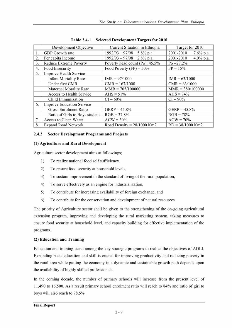
Table 2.4-1 indicates “Selected Development targets for 2010”.
For Ethiopia to reduce extreme poverty, as per the target set as Table 2.4-1, high and sustained economic growth is the most important strategy. The pattern of growth has to be broad-based with an underlying structural transformation. For average income to improve as per the target, a sustainable economic growth of at least 7.6% p.a. is envisaged.
The estimated growth rate of agriculture, the mainstay of the economy, is expected to be at least 5.0% p.a. on the average.
The Ethiopian Government in 1993 adopted the Agricultural Development Led Industrialization Strategy (ADLI). This strategy aims at improving agricultural production and productivity as a basis for improved income and living standard for the small holder farming population. Improved farm income would also generate sufficient demand for the industrial sector instigating dynamism and inter-sector linkages.
Final Report
2 - 8
The Study on Telecommunications Development Plan, Ethiopia
Table 2.4-1 Selected Development Targets for 2010
Development Objective Current Situation in Ethiopia Target for 2010 1. GDP Growth rate 1992/93 – 97/98 5.8% p.a. 2001-2010 7.6% p.a. 2. Per capita Income 1992/93 – 97/98 2.8% p.a. 2001-2010 4.0% p.a. 3. Reduce Extreme Poverty Poverty head count (Po): 45.5% Po =27.2% 4. Food Insecurity Food Poverty (FP) = 50% FP = 15% 5. Improve Health Service Infant Mortality Rate IMR = 97/1000 IMR = 63/1000 Under five CMR CMR = 167/1000 CMR = 63/1000 Maternal Morality Rate MMR = 705/100000 MMR = 380/100000 Access to Health Service AHS = 51% AHS = 74% Child Immunization CI = 60% CI = 90% 6. Improve Education Service Gross Enrolment Ratio GERP = 45.8% GERP = 45.8% Ratio of Girls to Boys student RGB = 37.8% RGB = 78% 7. Access to Clean Water ACW = 30% ACW = 70% 8. Expand Road Network Road Density = 28/1000 Km2 RD = 38/1000 Km2
2.4.2 Sector Development Programs and Projects
(1) Agriculture and Rural Development
Agriculture sector development aims at followings;
1) To realize national food self sufficiency,
2) To ensure food security at household levels,
3) To sustain improvement in the standard of living of the rural population,
4) To serve effectively as an engine for industrialization,
5) To contribute for increasing availability of foreign exchange, and
6) To contribute for the conservation and development of natural resources.
The priority of Agriculture sector shall be given to the strengthening of the on-going agricultural extension program, improving and developing the rural marketing system, taking measures to ensure food security at household level, and capacity building for effective implementation of the programs.
(2) Education and Training
Education and training stand among the key strategic programs to realize the objectives of ADLI. Expanding basic education and skill is crucial for improving productivity and reducing poverty in the rural area while putting the economy in a dynamic and sustainable growth path depends upon the availability of highly skilled professionals.
In the coming decade, the number of primary schools will increase from the present level of 11,490 to 16,500. As a result primary school enrolment ratio will reach to 84% and ratio of girl to boys will also reach to 78.5%.
Final Report
2 - 9

The Study on Telecommunications Development Plan, Ethiopia
Major areas of Intention include as follows;
1) To improve educational quality and expanding access to education with special emphasis on primary education in rural and under served areas, as well as the promotion of education for girls,
2) To update the existing schools and building new ones that can accommodate more pupils,
3) To improve the quality and efficiency of education in general and primary and secondary schools in particular by improving the standard of schools and upgrading the skill as well as the professional competence of teachers at all levels,
4) To improve access to educational opportunity by adopting a system of eight years of school for all thereby helping families afford schooling and encouraging communities to educate girls and to delay marriage, and
5) To strengthening the capacity of regions to implement the Education Sector Development program.
(3) Health
Ethiopia adopted and started implementing a Health Sector Development Program (HSDP) with a goal of universal primary health care for all by 2015. The focus of HSDP is on reproductive health care, treatment and control of basic infectious diseases, control of epidemic diseases, immunization and control of sexually transmitted diseases.
The following activities will receive due attention over the coming years;
1) To improve the performance of the health system through assuring accessibility of
health care for all segments of the population,
2) To develop the preventive and promotion components of health care,
3) To strength capacity for health sector planning and provisions through developing appropriate capacity of both health professionals and health administrators,
4) To ensure the financial sustainability of the health service through developing an equitable and acceptable standard of health service,
5) To promote attitudes and practices that enable to strengthen self reliance in health development through mobilizing and maximizing utilization of internal and external resources, and
6) To promote the participation of the private sector and NGOs in health care provision.
(4) Infrastructure Development
The general state of the construction industry in Ethiopia is characterized by low capacity which could not handle large construction demands.
(a) Road Transport
According to the Road Sector Development Program (RSDP), total expansion of the road network between the years 2001 – 2010 is expected to reach 13,600 km.
Final Report
2 - 10

The Study on Telecommunications Development Plan, Ethiopia
In addition to the existing network, 800 km of trunk roads, 2,300 km of major link roads and 10,500 km of rural roads is expected to constructed under the program.
(b) Communication
According to the Sector development program which runs up to 2004/05, the following sector targets are expected to be met;
1) To provide telephone services to 238 hitherto unconnected rural towns. This makes up about 65% of the number of currently unconnected rural towns;
2) To increase the shared lines connected to digital automatic exchanges to 100% from 64% in 1999/2000;
3) To increase the number of direct telephone lines from an estimated 249 thousands in 1999/2000 to 1.1 million in 2004/05; and
4) To increase the penetration of Internet and mobile telephone services by 14 and 5 fold respectively during the program period.
(c) Power
The government launched a ten-year Power Sector Development Program (PSDP) for the period 1997/98 – 2006/07 which is currently under implementation. Among the targets include expanding the generation capacity of the power system by about 600MW before the year 2010.
Outline of Energy policy is outlined the need to rely mainly on hydropower to increase supply of electricity and to take advantage of geothermal, solar, wind and other renewable energy resources wherever appropriate.
(d) Water Sector Development
Strategically developing the water resource in Ethiopia is the most important issue requiring urgent attention for its role in reducing vulnerability to drought, in reducing poverty and achieving food self sufficiency objectives.
It is planned to raise the proportion of population having access to safe water supply to 70% by the end of the decade. Feasibility Study and design of 385 irrigation projects covering an area of 501,685 hectares will be carried out and 200,000 hectares are planned to be developed.
2.5 Regional Development
(1) Administrative Structure
Federal Democratic Republic of Ethiopia is divided into smaller administrative units as follows:
* Regional States (9): namely, Tigrey, Afar, Amhara, Oromiya, Somali, Benishangul-Gumuz, SNNPR, Gambella, Harari, or Administration Regions (2): Addis Ababa, Dire Dawa (provisional)
* Zones (66): administrative units of Regional Governments
* Weredas (550 as of 1998) / Special Weredas (6 as of 1998)
* Kebele.
Final Report
2 - 11

The Study on Telecommunications Development Plan, Ethiopia
Proclamation No. 7 of 1992 established 14 National Regional Self Governments, on the basis of settlement, language, identity and willingness of nations, nationalities and peoples, as Regions 1 to 14. Later five Regions of 7 to 11 willingly merged as South Ethiopia Nations, Nationalities and Peoples Region (SNNPR).
Legislative bodies at the Federal level consist of the Council of People’s Representative (CPR) and the Federal Council (FC). Each member of CPR is elected from 100,000 people and 20 seats in CPR are reserved for minority groups with the population less than 100,000. Members of FC are elected by Regional Councils and additional members represent one million people. Executive power at Federal level is led by Council of Ministers which is responsible to the CPR.
Regional and Wereda Governments have respective Councils as the legislative body and the respective Executive Committees as the executive organ. Members of these Councils are elected by the people. Members of the Executive Committee, 11 to 19 in case of Regions and 9 to 11 in case of Weredas, are elected among the members of respective Councils. The members of the Executive Committee are responsible for policy and decision making of the Region or Wereda and to the respective Councils.
Zones do not have legislative bodies. Regional governments can establish additional administrative units, i.e. zones, between Region and Wereda level taking into account the area and population of the respective regions, according to the Proclamation No. 7 of 1992. Actually all Regions are divided into some zones, whose number in a Region varies from two to ten. Kebele administrations are initiated for the purpose of realizing full participation of population at grassroots level to social, political and administrative matters. The Kebeles also have elected councils and executive members.
Federal Government is responsible for defense, foreign affairs, economic policy, citizenship, declaration of state of emergency, deployment of army, printing currency, administering development establishments and communication networks.
Decentralization is in progress involving devolution of political or legal powers from the Federal to lower units. According to the Constitution, powers of the regional governments extend most parts of their public administration except those listed above, including formulating and executing regional constitutions, and economic and social development policies and strategies, and the responsibility Federal or Central Government is limited to inter-regional planning.
Despite full devolution of legal powers and duties on papers, the regional governments have much to do and yet to be assisted in terms of financial and human resource capacities. Most regional development plans effective during the period from 1995/96 to 1999/2000, those for the next five years are not available in English so far, appear;
- to be ‘standardized’,
- to have few unique programs or project derived from aspiration of local communities in the respective regions,
Final Report
2 - 12

The Study on Telecommunications Development Plan, Ethiopia
- not to be well prioritized with assessment of specific local needs,
- to have no implementation schedules,
- not to have clearly defined actions or duties of regional governments, or demarcation between the Federal and the respective regional governments,
- to be kinds of lists of necessities of assistance from the Federal Governments,
- not to be well integrated or coordinated among the sectors, and to be a mixture of regional plans formulated by the respective sectoral departments of the Federal Governments.
(2) Level of Regional Development
(a) People and Land
Oromiya, Amhara and SNNPR are large regions in terms of size of population, whose shares are 35%, 26% and 20%, respectively. Tigrey and Somali share nearly 6% of total population of Ethiopia. Afar, Benishangul/Gumuz, Gambella, Harari and Dire Dawa have minor population shares. Oromiya (33%), Somali (20%), Amhara (17%) and SNNPR (10%) are large in terms of land area, while Harari, Addis Ababa and Dire Dawa have very little share in land area. Regarding population density, the regions can be clearly classified into three types. Addis Ababa, Harari and Dire Dawa have high population density. Gambella, Benishangul/Gumuz, Afar and Somali are sparsely populated whose population density is less than one third of the average of Ethiopia. In Tigrey, Amhara, Oromiya and SNNPR, population density is near the average of Ethiopia.
Table 2.5-1 Population and Land Area of the Regions
Region Population (in 1,000, July 2001)
Share in Population
(%)
Area (1,000km2)*
Share in Land (%)
Population Density
(person/km2)
Regional Capital
Density Index
(av.=100)Tigrey 3,797 5.8% 60.2 5.5% 63.1 Mekele 105Afar 1,243 1.9% 77.0 7.1% 16.1 Semera 27
Amhara 16,748 25.6% 188.8 17.3% 88.7 Bahir Dar 148Oromiya 23,023 35.2% 360.0 33.1% 64.0 Nazret 107Somali 3,797 5.8% 215.9 19.8% 17.6 Jijiga 29
Benishangul/Gumuz 551 0.8% 46.8 4.3% 11.8 Assosa 20SNNPR 12,903 19.7% 112.0 10.3% 115.2 Awasa 192
Gambella 216 0.3% 26.1 2.4% 8.3 Gambella 14Harari 166 0.3% 0.3 0.0% 553.3 Harar 922
Addis Ababa 2,570 3.9% 0.4 0.0% 6,425.0 Addis Ababa 10,709Dire Dawa 330 0.5% 1.6 0.1% 206.3 Dire Dawa 344
Total/Average 65,344 100.0% 1,089.1 100.0% 60.0 --- 100
(Source) Statistical Abstract 2000, Central Statistical Authority (CSA), Aspect of Development Issues in Ethiopia, Institute of Development Research (IDR)-Addis Ababa University, November 1999.
(Note) * Data on land areas are quite vary depending on data source. In Statistical Abstract 2000 data for Afar and Somali Region are missing. Due to no availability of reliable data, data from IDR is applied in this table although the data seems not precise.
Final Report
2 - 13

The Study on Telecommunications Development Plan, Ethiopia
In Ethiopia, urban area is defined as dwelling area whose population is over 1,000. Addis Ababa, Dire Dawa and Harari are much more urbanized than the average, and these three are sometimes called as urban or municipal regions. On the contrary, Afar, SNNPR and Benishangul/Gumuz are less urbanized even compared to the average. Tigrey and Gambella are slightly more urbanized, while Amhara and Oromiya are slightly less urbanized. Somali has almost same share of urban population as the average of Ethiopia.
Table 2.5-2 Urban and Rural Population by Region
Region Urban
Population (in 1,000)
Share to the Total of the Region
Rural Population (in 1,000)
Share to the Total of
the Region
Total
Tigrey 651 17% 3,146 83% 3,797Afar 103 8% 1,140 92% 1,243
Amhara 1,759 11% 14,989 89% 16,748Oromiya 2,782 12% 20,241 88% 23,023Somali 586 15% 3,211 85% 3,797
Benishangul/Gumuz 50 9% 501 91% 551SNNPR 1,008 8% 11,895 92% 12,903
Gambella 37 17% 179 83% 216Harari 101 61% 65 39% 166
Addis Ababa 2,570 100% 0 0% 2,570Dire Dawa 239 72% 91 28% 330
Total/Average 9,886 15% 55,458 85% 65,344(Source) Statistical Abstract 2000, Central Statistical Authority (CSA)
Central highlands areas are dwelled by substantial amount of peoples with moderate rainfall. Most of these areas are traditionally used for agriculture, and cities and towns are scattered there. According to the land use, population concentration occurs in highland areas of the central part of the country. The central highlands extend major parts of Tigrey, Amhara, central part of Oromiya and northern part of SNNPR, as well as southern small part of Benishangul/Gumuz.
Eastern half of Ethiopia is dry, and shrubbery lands and exposed rock or sand areas are dominant in these parts. These parts are used only for livestock breeding with low intensity. People are sometimes nomads there. In these parts, population density is very low and towns are rarely developed. Some northwestern part of Tigrey, and most parts of Afar and Somali belong to this category.
Forest cover extends in the areas south to the central highlands. Gambella has substantial areas of forests.
(b) Human Resources Development
Two types of data, i.e. those on education and health, are analyzed to assess the present level of human resource development of regions. The table below shows gross enrollment rate (GER, number of pupils or students/number of children at the age corresponding to the grade) of primary and secondary education by region.
Final Report
2 - 14

The Study on Telecommunications Development Plan, Ethiopia
Regarding primary education, GER in Addis Ababa (118%) is more than double of the average of Ethiopia. Harari (105%), Gambella (96%), Benishangul/Gumuz show substantially higher GERs at the primary level than the average. Dire Dawa, Tigrey and SNNPR also show higher GERs in primary education. The GERs in Oromiya and Amhara is near the same of Ethiopian average. In Afar and Somali, the GERs are extremely low, almost one fifth of the average.
As for GER of the secondary education, Regional disparity is quite large. Urban regions, such as Addis Ababa, Harari and Dire Dawa, show GERs of more than two times of the average. The GERs at secondary level of Tigrey and Gambella are quite higher than the average. It should be noted that the index of Tigrey at the secondary level is considerably higher than that of primary education. These two GERs in Gambella show opposite figures, higher in primary education and lower in secondary one. The GER and indices of the secondary education in Afar and Somali are very low as those of the primary ones.
Table 2.5-3 Gross Enrollment Rate (%, 2000/01) by Region
Primary (Grade 1-8) Secondary (Grade 9-12)
Region Boys Girls Both
Index - both sex (average
=100) Boys Girls Both
Index - both sex (average
=100) Tigrey 75.9 71.8 73.9 129 28.5 17.5 23.0 178Afar 12.7 9.8 11.5 20 3.4 3.2 3.3 26
Amhara 56.9 49.7 53.3 93 10.1 8.8 9.5 74Oromiya 73.5 42.1 57.9 101 13.3 8.3 10.8 84Somali 13.4 7.2 10.6 18 0.8 0.4 0.7 5
Benishangul/Gumuz 112.7 63.3 88.5 154 13.8 6.3 10.1 78SNNPR 80.8 46.7 63.8 111 13.0 6.3 9.7 75
Gambella 117.1 73.0 95.8 167 27.5 7.9 17.9 139Harari 120.8 89.1 105.3 183 55.0 45.6 50.2 389
Addis Ababa 118.0 118.5 118.3 206 67.7 55.1 60.7 471Dire Dawa 84.1 67.1 75.7 132 37.5 27.1 32.0 248Average 67.3 47.0 57.4 100 14.8 10.9 12.9 100
(Data Source) Education Statistics Annual Abstract 2000-01, Ministry of Education
Health data are analyzed in terms of facilities and medical staff. Regional data on population per health facilities as well as health staff are compared. In the following two tables larger indices mean worse facility or staffing conditions.
Harari and Dire Dawa have very small population for a hospital beds. In Benishangul/ Gumuz, Gambella, Addis Ababa and Tigrey, populations for a hospital bed are nearly one third of the average. SNNPR, Amhara, Somali and Oromiya have substantially larger populations than the average. Harari, Gambella, Benishangul/Gumuz have much smaller populations per clinic than the average. In other regions, population for a clinic is almost same as the average except Somali, where population for a clinic is nearly double of the average.
Final Report
2 - 15

The Study on Telecommunications Development Plan, Ethiopia
Table 2.5-4 Health Facilities (1999/2000) by Region
Region Population/
Hospital Bed Index - Hospital
Bed (Average=100)Population/Clinic
Index -Clinic (Average=100)
Tigrey 2,996 38 23,233 96Afar 5,846 74 22,109 91
Amhara 12,681 161 23,858 98Oromiya 10,363 132 22,951 95Somali 11,556 147 47,410 196
Benishangul/Gumuz 2,114 27 7,458 31SNNPR 13,342 170 25,181 104
Gambella 2,453 31 4,396 18Harari 461 6 4,103 17
Addis Ababa 2,712 34 --- --- Dire Dawa 994 13 19,875 82Average 7,870 100 24,225 100
(Data Source) Statistical Abstract 2000, Central Statistical Authority (CSA)
As for population for a doctor, regional disparity is quite large. Harari, Dire Dawa, Addis Ababa, Gambella and Benishangul/Gumuz have much smaller populations for a medical doctor. Other regions, except SNNPR where same population has on medical doctor, have quite larger population for a doctor. Somali is an extreme case, where more than 500 thousand people have only one doctor.
Harari, Dire Dawa, Addis Ababa, Gambella and Benishangul/Gumuz also enjoy large numbers of nurses and health assistants. In Tigrey, the indices for nurses and health assistants are better than the average on the contrary to the index of medical doctor. The index of health assistants in Oromiya is also better than the averages. The index of health assistants in Somali is slightly better than the average.
Table 2.5-5 Health Staff (1999/2000) by Region
Region
Population/ Medical Doctor
(in 1,000)
Index- Medical Doctor
(Average=100)
Population/Nurse
Index - Nurse (Average=100)
Population/ Health
Assistant
Index - Health Assistant
(Average=100)
Tigrey 74 134 9,496 71 4,577 61 Afar 72 130 7,845 59 14,829 196
Amhara 78 141 18,065 135 9,441 125 Oromiya 69 125 18,100 135 6,747 89 Somali 528 958 12,796 96 17,951 237
Benishangul/Gumuz 21 37 2,620 20 3,949 52 SNNPR 55 100 13,875 104 8,691 115
Gambella 16 29 1,426 11 2,453 32 Harari 3 6 1,260 9 1,569 21
Addis Ababa 13 24 8,816 66 5,871 78 Dire Dawa 9 16 2,814 21 4,543 60 Average 55 100 13,373 100 7,565 100
(Data Source) Statistical Abstract 2000, Central Statistical Authority (CSA)
Final Report
2 - 16

The Study on Telecommunications Development Plan, Ethiopia
(c) Economic Infrastructure and Investment
As important data for economic infrastructure, road length per 100 km2 of land, electricity distribution for one thousand persons and telephone density are analyzed.
Addis Ababa, Harari have high road density. Dire Dawa seems to suffer low road density. Other than municipal regions, SNNPR, Oromiya, Tigrey and Amhara have comparatively high road density. As for electricity, its distribution is highly concentrated in the three municipal regions.
Table 2.5-6 Development of Economic Infrastructure by Region
Region Road Density
(km/ 1,000 km2, 1996/97)
Index - Road (average=
100)
Kwh/1,000 person
(1995/96)
Index - Electricity (average=
100)
Telephone Density (line/100 person)
Index- Telephone (average
=100) Tigrey 25.91 118 5,927 26 0.3063 84Afar 10.94 50 1,153 5 0.0543 15Amhara 25.29 115 7,619 34 0.1570 43Oromiya 28.64 131 18,469 81 0.1657 45Somali 5.85 27 4,590 20 0.0305 8Benishangul/Gumuz 8.63 39 1,299 6 0.0793 22SNNPR 38.21 174 3,686 16 0.0940 26Gambella 12.34 56 8,382 37 0.2607 71Harari 63.33 289 121,833 537 2.0219 553Addis Ababa 175.00 798 286,643 1,263 5.3602 1,467Dire Dawa 28.85 132 208,501 918 2.0456 560Total/Average 21.94 100 22,704 100 0.3653 100(Data Source) Aspect of Development Issues in Ethiopia, IDR-Addis Ababa University, November 1999, and
Transport and Communication Statistics, Statistical Bulletin 246, CSA
Capital investment is much concentrated in urban regions. Nearly half amount of investment was approved for Addis Ababa. Investment in Dire Dawa had grown largely and its per capita in 1998 ranked second next to Addis Ababa, while per capita index of Harari had slightly decreased. Despite substantial increase in total capital investment over Ethiopia, the share of Tigrey and Afar and had considerably decreased up to 1998, probably due to the political and economic tension with Eritrea.
Final Report
2 - 17

The Study on Telecommunications Development Plan, Ethiopia
Table 2.5-7 Regional Distribution of Approved Capital Investment
Region
Capital Investment (million Birr, up to Jan.
1996)
Share (up to Jan.
1996)
Per Capita
(Birr, up to Jan. 1996)
Index-per
Capita 1996
Capital Investment (million Birr,
up to Jul. 1998)
Share (up to Jul.
1998)
Per Capita
(Birr, up to Jul. 1998)
Index- per
Capita 1998
Increment of the
amount
Change in Index
Tigrey 3,040.2 20% 927 347 3,859.9 11% 1,122 180 27% -167
Afar 995.7 7% 897 336 1,513.8 4% 1,305 209 52% -127
Amhara 554.7 4% 39 14 2,760.8 8% 183 29 398% 15
Oromiya 1,985.9 13% 102 38 5,310.7 15% 259 42 167% 3
Somali 102.0 1% 31 11 141.9 0% 40 6 39% -5
Benishangul/Gumuz 159.5 1% 332 125 306.3 1% 607 97 92% -27
SNNPR 690.5 5% 64 24 1,803.4 5% 159 26 161% 2
Gambella 21.3 0% 112 42 56.2 0% 282 45 163% 3
Harari 183.0 1% 1,307 490 418.2 1% 2,807 450 129% -40
Addis Ababa 7,124.0 48% 3,152 1,181 19,093.8 52% 7,858 1,260 168% 79
Dire Dawa 34.7 0% 128 48 1,310.6 4% 4,567 732 3681% 684
Total/Average 14,891.6 100% 267 100 36,575.5 100% 624 100 146% ---
(Data Source) Aspect of Development Issues in Ethiopia, IDR-Addis Ababa University, November 1999
(3) Potential of Regional Development
(a) Agriculture and Related Industry and Commerce
Since central highlands are suitable for agriculture, towns located there have been developed as and have good potential for related industries, such as food processing, and trading/commerce of agricultural products and inputs, as well as related service, such as transportation. Major towns of the central highlands, such as those in Tigrey, Amhara, Oromiya, Addis Ababa, and northern part of SNNPR have developed and have potential to be developed further as commercial and industrial centers.
Western, and southwestern of parts the country, such as those in Oromiya, Amhara, SNNPR, Benishangul/Gumuz and Gambella have substantial area of irrigable lands with abundant water resource potential. In case irrigation projects are implemented in these area, agricultural production will grow, followed by development of related industries and commerce in towns of the areas.
Exportable agricultural crops are produced over the country in arable areas as described above. Coffee production prevails in the northwestern and central regions, such as Amhara, Oromiya, SNNPR, Harari and Dire Dawa. Oil seeds production spreads over the country, while cotton is produced in Regions of Tigrey, Afar, Amhara, Oromiya, Somali and Gambella. Much volume of cereals is exported from Amhara and Oromiya. Further development of exportable or cash crops may contribute to commercial development of the towns in these regions.
Final Report
2 - 18

The Study on Telecommunications Development Plan, Ethiopia
Ethiopia ranks top level of the world in terms of livestock population. Oromiya, Amhara, SNNPR and Somali are known as regions with much livestock population. By promotion of quality improvement, export of livestock products, such as meat, hides and skins, as well as leather products, is expected to grow.
(b) Mineral
Tigrey is endowed various kinds of mineral resources, such as gold, copper, iron, zink, nickel and lead, although detail studies on volume of reserve and feasibility has not yet conducted. Amhara and Oromiya also have good potential of mining development. Other regions also have some mineral reserves, such as natural gas in Somali and Afar. Most of the potential is yet to be developed.
(c) Tourism
Most of the regions have various tourism attractions and potential of tourism development. Northern parts, such as Tigrey and Amhara have historical monuments, churches and castles. Afar has the famous remain of the human ancestor, “Lucy”. Lakes and caves attract tourists to Oromiya and SNNPR. National parks, game reserves, sanctuaries and other natural attractions are found over the country. With development of transportation and accommodation infrastructure as well as conservation of these attractions, tourism of Ethiopia has much potential to be developed further. Telecommunication sector can take important role for promotion of the tourism development.
(4) Regional Development and Telecommunication Development
As can be seen in the proclamation and regulations related to telecommunications and in “National Communication Policy”, telecommunication sector should serve to the development of economy and industries, in parallel with providing universal access to local communities.
As described above, current development level of the regions can be summarized as the following three groups.
Urban Areas: Addis Ababa, Dire Dawa and Harari are urban regions, most of whose areas composed of urban areas. Economic infrastructure as well as social infrastructure is comparatively well developed in these areas. Concentration of telecommunication networks in Addis Ababa seems to be extremely higher than that of other economic infrastructure (electricity and roads). Other areas of this category need to be prioritized in telecommunication development.
Central Highland Areas: Most part of Tigrey and Amhara, central part of Oromiya, and northern part of SNNPR belong to this category. Other regions have very limited portion of this area. The areas of this category have moderate rainfall, and rainfed agriculture has been historically prevailing. In these areas, social infrastructure has been developed at the average or slightly higher level. Major towns in these areas should have a priority in roll-out targets of economic infrastructure, including telecommunication services.
Final Report
2 - 19

The Study on Telecommunications Development Plan, Ethiopia
Final Report
2 - 20
Marginal Areas: These areas surround the central highlands. Most parts of Afar, Benishangul/Gumuz, Gambella and Somali, and southern parts of SNNPR and Oromiya fall to this category. In these areas, rainfall is normally not enough for agriculture, modern agriculture has not developed, and people have sparsely populated, although there is some potential for agricultural development with irrigation projects in southern and western areas. Social infrastructure, as well as economic infrastructure, has been less developed than the average of the country. For these areas, development of social infrastructure for basic human needs should have higher priority than the development of economic infrastructure. Among economic infrastructure, road construction, and probably electrification as well, may have higher priority than telecommunication development.
Universal access to telecommunication services should be pursued over the country. However, with limited resources available, realization of the universal access should be cost efficient. Selection of target local community should be made taking into account of costs for network expansion, size of population and social and economic importance of the communities.