chapter 2: project alternatives 2-1 introduction chapter 2: project alternatives 2-1 introduction...
TRANSCRIPT

2-1
Chapter 2: Project Alternatives
2-1 INTRODUCTION
The development and evaluation of project alternatives is central to the National Environmental Policy Act (NEPA) and State Environmental Quality Review Act (SEQRA) processes. This chapter describes the alternatives for the Tappan Zee Hudson River Crossing Project that are evaluated in this Environmental Impact Statement (EIS), as well as alternatives that were previously considered but were eliminated during the scoping process for this EIS and the reasons for their elimination.
This EIS considers two alternatives for the Tappan Zee Hudson River crossing as follows:
No Build Alternative. The No Build Alternative would involve the continued operation of the existing seven-lane bridge with ongoing maintenance and measures necessary to keep the bridge in a state of good repair; and
Replacement Bridge Alternative. The Replacement Bridge Alternative would replace the existing Tappan Zee Bridge with two new structures (one each for eastbound and westbound traffic) to the north of its existing location.
The location and general characteristics of the Replacement Bridge Alternative have been identified and are the basis of the impacts assessment in this EIS. However, to provide for flexibility in the final design of the Replacement Bridge Alternative, this EIS considers options for certain structural characteristics of the bridge (i.e., the distance between bridge piers and the type of bridge structure across the navigable channel). The Replacement Bridge Alternative options that are under consideration are described in Section 2-2, below.
A Rehabilitation, Tunnel, and Single Structure Alternative were also considered. As described below, the Rehabilitation, Tunnel, and Single Structure Alternatives are not prudent because they would not meet the project’s goals and objectives. Therefore, this EIS does not assess a Rehabilitation, Tunnel, or Single Structure Alternative for the Tappan Zee Hudson River Crossing Project.
2-2 ALTERNATIVES ANALYZED IN THIS ENVIRONMENTAL IMPACT STATEMENT
The following describes the No Build and Replacement Bridge Alternatives, which are analyzed in detail in this EIS.

Tappan Zee Hudson River Crossing Project Environmental Impact Statement
2-2
2-2-1 NO BUILD ALTERNATIVE
NEPA requires that an EIS consider a No Build Alternative. The No Build Alternative reflects the continuation of the existing Tappan Zee Hudson River crossing and serves as the baseline condition against which the potential benefits and impacts of the Replacement Bridge Alternative are evaluated.
Under the No Build Alternative, the Tappan Zee Bridge would retain its current, seven-lane configuration. The New York State Thruway Authority (NYSTA) would continue maintenance of the bridge and would invest capital funds to keep it in a state of good repair. NYSTA estimates that it would spend $1.3 billion to maintain and repair over the next decade (see Appendix A). Major work activities would include seismic upgrades to portions of the bridge, navigational safety improvements, steel and concrete repairs, and other miscellaneous work to continue to keep the bridge safe for the traveling public.
Extraordinary maintenance efforts and capital projects would ensure that the bridge continues to be safe to the traveling public, but these projects would not correct all of the structural, operational, safety, security, or mobility needs of the bridge as described in Chapter 1, “Purpose and Need.” Therefore, given the age of the bridge and its vulnerabilities in extreme events, it is possible that under the No Build Alternative, the crossing could be closed altogether at some point in the future, resulting in the loss of a critical infrastructure element to an important transportation corridor.
As described in Chapter 1, “Purpose and Need,” the New York Metropolitan Transportation Council (NYMTC) projects substantial population and employment growth in Westchester and Rockland Counties over the next 30 years. This growth is expected independent of alternatives for the Tappan Zee Hudson River crossing and is the baseline for evaluating the potential impacts of the project alternatives. In addition to the growth projected by NYMTC, there are specific projects that will be undertaken independent of the project alternatives for the Tappan Zee Hudson River crossing. These projects are shown in Tables 2-1 and 2-2.
Table 2-1Planned Developments Within the Study Area
Jurisdiction Development Name Development Description Status
Tarrytown Crescent Associates 60,000-square-foot, 3-story office building, with accessory parking to join two existing office buildings; located opposite Interstate 87/287 ramps at 155 White Plains Road
Approved
Tarrytown Jewish Community Center on the Hudson
(JCC)
The JCC purchased the adjacent property, the former GM Training Center at 425 South Broadway, and plans to expand with the creation of a new campus on the two properties (approximately 75,000 square feet on 6.6 acres). The campus is located 500 feet south of the New York State Interstate 87/287 on Route 9.
Approved
Tarrytown Jardim Estates Subdivision of up to 50 single family residences In approvals process

Chapter 2: Project Alternatives
2-3
Table 2-2Notable Transportation Improvement Program (TIP) Projects
in the Study Area
Agency Project Number Project Description
Rockland County Department of Transportation 1,3
882300 8TM023 8TM024
Tappan Zee Express bus expansion; purchase of transit support vehicles; purchase of ADA-compliant vans and buses for Trips Program
Town of Orangetown 2 875967 Traffic signal improvements: at 28 intersections in Orangetown
NYSDOT 3 810322 Reconstruction of Route 9/Route 119 (Executive Boulevard) as a four-lane divided roadway with left-turn bays and new sidewalks
Village of Tarrytown 2 875976 Traffic signal improvements at five intersections along Route 9 in Tarrytown
Town of Greenburgh 2 878012 1 mile of trail to link Lyndhurst and Sunnyside historic sites
NYSDOT 1 882161 Orange-Westchester Link (OWL): peak-hour commuter between Route 17 (I-86) corridor to Westchester County with connections to other services (Tappan Zee Express, I-bus & local service).
Sources: 1 New York Metropolitan Transportation Council (NYMTC) Transportation Improvement Program (TIP)
Federal Fiscal Years 2008-2012, Adopted October 29, 2007, and last revised September 7, 2011. 2 Draft Federal Fiscal Years 2011-15 Transportation Improvement Program, June 2011. 3. Mid-Hudson South Transportation Coordinating Committee, TIP Amendment: MH12-09 (June 2012).
The assessment of the No Build Alternative in this EIS accounts for background growth, which includes the specific projects described above.
2-2-2 REPLACEMENT BRIDGE ALTERNATIVE
The Replacement Bridge Alternative would result in a new bridge crossing of the Hudson River between Rockland and Westchester Counties.
2-2-2-1 DESIGN PARAMETERS
A number of design parameters have been considered to develop the location and general configuration of the Replacement Bridge Alternative. However, to provide for flexibility in the final design of the Replacement Bridge Alternative, this EIS considers options for certain structural characteristics of the bridge. The following describes the preferred location, the general characteristics, and the design options for the Replacement Bridge Alternative.
Location
The planning for the Replacement Bridge Alternative considered a footprint that would maximize the use of existing NYSTA right-of-way while minimizing effects on existing highway infrastructure in Rockland and Westchester Counties. Replacement bridge alignments both north and south of the existing Tappan Zee Bridge were considered.

Tappan Zee Hudson River Crossing Project Environmental Impact Statement
2-4
There is available NYSTA right-of-way to the north of the existing highway on both sides of the Hudson River to accommodate construction of a new crossing. Sufficient right-of-way is not available on the south side of the existing highway at the Rockland landing. A southern alignment would require cutting into the hill in Rockland and displacement of approximately 30 properties and potential implications of up to 20 others properties to stabilize the hill.
A north alignment also allows for a straight approach to the Westchester toll plaza. A south alignment would result in a conflict between the new crossing’s horizontal curvature and the approach to the toll plaza, which would not meet design and safety standards. Because of the offset in the highway the extent of the works would reach back through Interchange 10 (Route 9W) which would need to be reconstructed to provide the curvatures necessary to meet design speeds. On the Westchester side, the required horizontal curvature would be less than the minimum needed for the required design speed and would be unacceptable. In addition, a temporary toll plaza to the south of the existing toll plaza would be required during construction and would impact properties south of the existing NYSTA right-of-way.
Therefore, a replacement bridge to the north of the existing Tappan Zee Bridge is preferred and is being proposed.
General Configuration
Chapter 1, “Purpose and Need,” identified structural, safety, operational, and mobility deficiencies of the existing Tappan Zee Bridge. To address these deficiencies and with consideration of the project’s goals and objectives, the following design parameters have been incorporated into the general configuration of the Replacement Bridge Alternative.
Redundancy
Redundancy is a key consideration for the structural integrity and operational flexibility of a replacement bridge.
Structural redundancy (member redundancy, load path redundancy, and hardening and dispersion) would provide the bridge with the design capacity to withstand extreme events such as earthquakes, hurricanes, vessel allision, and fires. It would be achieved through a design that would include vertical and horizontal bridge elements that complement and support each other. In this way, the bridge would maintain its structural redundancy throughout the superstructure even if a single member should fail. Structural redundancy would be accomplished through a new bridge that meets current seismic structural and safety design standards.
Service redundancy would provide the bridge with the ability to maintain traffic flow during routine maintenance and extreme events. As described in Chapter 1, “Purpose and Need,” the Tappan Zee Hudson River crossing is a vital link between Rockland and Westchester Counties for 134,000 vehicles per day and is the only interstate crossing for a 48-mile stretch of the Hudson River. A full closure of the bridge would result in major disruption to traffic, long detours, and potentially an hour or more increase in travel time. To that end, the Replacement Bridge Alternative must include provisions to ensure that the crossing is not subject to full closure to the maximum extent feasible.

Chapter 2: Project Alternatives
2-5
Twin bridge structures would provide superior service redundancy as compared with a single structure. In the event that an incident or extreme event would require the closure of one structure, the second structure could remain open to traffic. At the same time, this redundancy would provide for flexibility in bridge inspection and maintenance. With a single structure, NYSTA would need to carefully plan and stage inspection and maintenance activities to retain open lanes across the bridge. As a result, repairs would take longer, cost more, and be more limited in scope than if a temporary closure could be implemented. With two separate structures, NYSTA would have much greater flexibility in planning for the bridge’s inspection, long-term maintenance, and future contract work, and therefore would ensure the structural and operational integrity of this vital link over a longer timeframe. This configuration would also provide for safer work zones for inspection, maintenance, and repair crews.
For these reasons, the Replacement Bridge Alternative would include two separate structures across the Hudson River.
Minimum Width
NYSTA would maintain traffic flow across the Hudson River to the maximum extent feasible, even if one of the two structures must be closed. To provide adequate capacity for such short-term traffic operations, each of the two road decks would need a minimum width of 87 feet to provide for a minimum of seven temporary highway lanes, shoulders, and an adequate buffer for two-way traffic operations in the event that one structure would be inoperable.
At present, bicycles and pedestrians are prohibited on the Tappan Zee Hudson River crossing, although there are existing multi-use trails near the bridge on both sides of the river. To maximize the public investment in a new crossing, a shared-use (bicycle/pedestrian) path would be provided across one of the spans of the replacement bridge. To meet current design standards for the path and to provide adequate separation from traffic lanes, the Replacement Bridge Alternative must provide a minimum of 12 feet of additional width for the shared-use path.
To meet these requirements, the Replacement Bridge Alternative’s structure that includes a shared-use path would be 96 feet wide. The Replacement Bridge Alternative’s structure that does not include a shared-use path would be 87 feet wide.
Gap
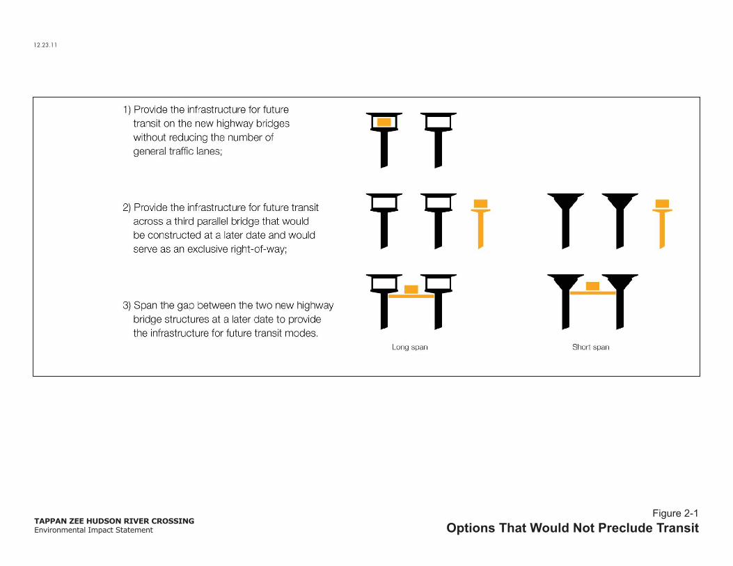
The gap between the two structures would affect the manner in which potential future transit modes could be provided in the corridor. As described in the Chapter 1, “Purpose and Need,” one of the project’s objectives is to provide a crossing that “does not preclude future trans-Hudson transit services” in the corridor. The following are options that would not preclude future transit on this corridor:
1) Allow for the incorporation of future transit on the new highway structures without reducing the number of general traffic lanes;
2) Provide for future transit across a third parallel bridge that would be constructed at a later date and that would serve as an exclusive transit right-of-way; or

Tappan Zee Hudson River Crossing Project Environmental Impact Statement
2-6
3) Provide additional structural support within the new highway structures as well as a gap between the new highway structures to allow for future transit modes to operate on a new deck that would span the gap at a later date.
These options are illustrated in Figure 2-1.
The Replacement Bridge Alternative would accommodate existing bus services across the Tappan Zee Hudson River crossing; however, the implementation of any options for future transit modes would require a separate and independent environmental review process when and if a proposal for transit services is foreseeable and financing is available. Implementation of future transit services would require modifications at the bridge landings to tie in to upland infrastructure for bus and/or commuter rail operations. There are various options for such upland connections.
Option 1 would allow for exclusive bus lanes within the left shoulders of the replacement bridge, but infrastructure to support the upland connections to these bus lanes would be needed in Rockland and Westchester Counties.
Option 2 could provide for a new exclusive or combined bus or commuter rail bridge across the Hudson River. However, Option 2 would be costly ($2 to $3 billion) and would result in work in the Hudson River (i.e., dredging and pile driving) for additional foundations to support piers for the new structure that could be avoided with implementation of either Option 1 or Option 3.
Option 3 would allow for either or both bus and commuter rail service across the Hudson River; however, additional strengthening of the new bridge would be required to support the additional loads from any potential transit service within the gap between the new structures. The additional current cost for strengthening the replacement bridge under Option 3, to allow for any future transit service within the gap between structures, would be approximately $200 to $300 million. Should implementation of transit occur in the future, an additional approximately $340 to $620 million (in 2012 dollars) would be required to implement the future infrastructure across the bridge, with an additional $4.4 to $4.6 billion for the commuter rail infrastructure, connections, and stations. In total, the current and future structural cost for transit service within the gap would be $540 to $920 million. In comparison, a new, exclusive transit bridge across the river (i.e., Option 2) would cost between $2 and $3 billion just for the new structure. In short, Option 3 would save between $1.5 and $2 billion as compared to Option 2.
Consistent with and in furtherance of the project’s goal to “maximize the public investment in a new trans-Hudson crossing,” planning for additional strengthening and a gap between the two new structures to facilitate Option 3 for transit service is considered prudent at this time. To that end, the Design-Build Contract Documents (Part 3 § 11.3.1.10.3) include specific provisions for a potential future load, assuming the American Railway Engineering and Maintenance-of-Way Association (AREMA) Manual for Railway Engineering (2012) requirements for commuter rail service. Furthermore, a 40-foot gap would be provided between the highway structures at the main span towers. The gap would narrow as it approaches landings, but the transit structure and its connections could be provided at a lower elevation (i.e., below the highway deck) at this location. As noted above, the tie-in at the Rockland and Westchester landings may require future modification of highway infrastructure.
12.23.11
TAPPAN ZEE HUDSON RIVER CROSSINGEnvironmental Impact Statement
Figure 2-1Options That Would Not Preclude Transit

Chapter 2: Project Alternatives
2-7
Any option for future transit service would require additional funds as well as land for construction of upland transit infrastructure (i.e., right-of-way, stations, parking, and ancillary facilities). A bus rapid transit service along this corridor between Suffern and Port Chester would cost an additional $4.5 to $5.3 billion (in 2012 dollars) for a total of approximately $10 billion when including the cost of the replacement bridge. The additional cost of commuter rail service between Suffern and the Metro-North Hudson Line in Tarrytown would cost approximately $4.4 to $4.6 billion (in 2012 dollars) for a total of approximately $15 to $16 billion when including the replacement bridge and BRT. Appendix A provides further information regarding the cost of transit options.
Summary
The design parameters described above identify the location and general characteristics of the Replacement Bridge Alternative. In summary, the Replacement Bridge Alternative would:
Be located to the north of the existing Tappan Zee Bridge;
Include two separate spans to provide service redundancy;
Have a 96-foot-wide deck for the superstructure that includes a shared-use path;
Have a 87-foot-wide deck for the superstructure that does not include a shared-use path;
Have a gap between the two bridge structures; and
Maximize the public investment by providing additional strengthening so as not to preclude future transit services.
These design parameters have been incorporated into the following description of the Replacement Bridge Alternative. Appendix A provides the design criteria for the Replacement Bridge Alternative.
2-2-2-2 DESCRIPTION OF THE REPLACEMENT BRIDGE ALTERNATIVE
Pursuant to New York State legislation passed in December 2011, the New York State Department of Transportation (NYSDOT) and NYSTA have advanced this project under a Design-Build contract. With this approach, NYSDOT and NYSTA would select a single Design-Builder to both complete the design and construct the Replacement Bridge Alternative. The selection of the Design-Builder is being accomplished through a two-step approach—first a Request for Qualifications (RFQ) would be used to develop a short-list of qualified firms, followed by a Request for Proposals (RFP). The RFQ was issued on November 28, 2011, and a short-list of firms was identified in February 7, 2012. The RFP (Design-Build Contract Documents) was issued on March 9, 2012, and formal proposals are due on July 27, 2012. The Design-Build Contract Documents specify basic design and planning guidelines, environmental performance commitments, and any additional mitigation required based on the analysis presented in the Draft EIS (DEIS) as well as further design refinements and environmental commitments identified in this Final EIS (FEIS). The winning Design-Build team will be selected in the fall of 2012.
As specified in 23 CFR § 636.109, the Design-Build process for this project must be coordinated with review under NEPA. The design options presented in the DEIS (short span vs. long span and cable-stayed vs. arch) provided an envelope for the possible

Tappan Zee Hudson River Crossing Project Environmental Impact Statement
2-8
final design of the Replacement Bridge Alternative (see Figure 2-2). While preliminary designs were identified in the DEIS, the Design-Builder has the option to propose alternative design concepts that are consistent with this FEIS, Record of Decision, and criteria of the Design-Build Contract Documents. The Design-Build process enables the Design-Builder to use innovation to further avoid, minimize and mitigate environmental effects and promote efficiency in cost and construction duration.
The following sections describe the preliminary design for the landings, approach spans, and main spans of the Replacement Bridge Alternative.
Landings
In Rockland and Westchester Counties, Interstate 87/287 would be shifted slightly northward to meet the new abutments of the Replacement Bridge Alternative.
Rockland County
Figure 2-3 shows a plan for the Rockland Landing. As will be described below, there are two options for the Replacement Bridge Alternative’s approach spans (Short Span and Long Span Options), which would result in somewhat different configurations of the Rockland County landing. Where notable differences between the Short Span and Long Span Options would occur at the landings, they are described below. Figure 2-3 reflects the Rockland County landing for the Short Span Option.
Subsequent to publication of the DEIS, the design of the Rockland County landing was refined to lower the profile of the highway between South Broadway and the bridge abutment at River Road. The lower profile applies to both the Short and Long Span Options. The modified Rockland County landing was formally incorporated into the Replacement Bridge Alternative and is assessed in this FEIS. The modified Rockland County landing supersedes the profile identified in the DEIS and eliminates the need to replace the South Broadway Bridge and acquire six residential properties (nine households) in the Village of South Nyack.
Approximately 500 feet east of the South Broadway Bridge, the roadway would begin to shift northward from its existing centerline. The highway would continue to operate with 10 lanes: 8 general traffic lanes (4 eastbound and 4 westbound) and 1 eastbound acceleration lane from Interchange 10 (Route 9W)1. Left and right shoulders would be provided in both directions. The eastbound acceleration lane would end approximately 500 feet east of Interchange 10 (Route 9W), and as it approaches the bridge, the roadway would consist of 8 general traffic lanes with left and right shoulders.
The new bridge abutment would be located approximately 75 feet west of River Road2. At the point where it meets the approach spans of the new bridge, the northern boundary of the highway would be approximately 100 feet north of its existing boundary. The highway would exit Rockland County at an elevation of between 19 and 25 feet above River Road.
1 Interstate 87 is signed as a north-south highway, and therefore, traffic is generally described as northbound and southbound. However, the highway has an east-west orientation through the Tappan Zee Hudson River crossing.
2 The measurement is from the middle of the abutment to River Road. River Road curves inward from the shoreline as it travels north. Thus, the north limit of the abutment is much closer to River Road than the south end of the abutment.
6.6.12
TAPPAN ZEE HUDSON RIVER CROSSINGEnvironmental Impact Statement
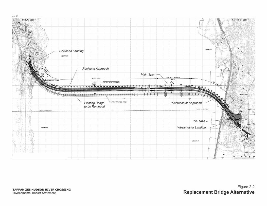
Figure 2-2Replacement Bridge Alternative
Rockland Approach
Rockland Landing
Main Span
Westchester ApproachExisting Bridgeto be Removed
Toll Plaza
Westchester Landing

6.6.12
TAPPAN ZEE HUDSON RIVER CROSSINGEnvironmental Impact Statement
Figure 2-3Rockland Landing
POSSIBLE LOCATION OF
POSSIBLE LOCATION OF
POSSIBLE LOCATION OF

Chapter 2: Project Alternatives
2-9
Reconfiguration of the Rockland landing would result in the construction of new eastbound and westbound maintenance ramps from Interstate 87/287 to River Road.1 For the Long Span Option, the eastbound maintenance ramp would extend about 100 feet further inland than in the Short Span Option. The longer maintenance ramp is required to meet the higher elevation of the highway in the Long Span Option.
Westchester County
Figure 2-4 shows the Westchester County landing. The new bridge would enter Westchester County with 60 feet of clearance above the Metro-North Railroad (MNR) Hudson line. The new bridge structures would straddle the centerline of the existing bridge, and the new alignment would extend approximately 100 feet to the north and 150 feet to the south of the existing bridge. The new bridge abutments would be located approximately 200 feet inland of the Hudson line.
In the eastbound direction, the modified Westchester landing, including the toll approach, would extend from approximately 2,300 feet west of the Westchester County bridge abutments to approximately 400 feet east of the Broadway Bridge (Route 9). Approximately 2,300 feet west of the Westchester County abutments, eastbound Interstate 87/287 would widen from four to five lanes. The three inner lanes would serve as highway-speed E-ZPass lanes through the Westchester County toll plaza. The right two lanes would serve cash/E-ZPass customers, and these two lanes would widen to seven cash/E-ZPass lanes through the toll plaza. In total, the highway would carry 10 lanes through the Westchester County toll plaza.
East of the toll plaza, the highway would narrow to six eastbound lanes, five general traffic lanes and one deceleration lane to Interchange 9 (Route 9). The highway-speed E-ZPass lanes would remain separated from the cash/E-ZPass to a point approximately 200 feet east of the Broadway Bridge (Route 9). Therefore, motorists that would exit at Interchange 9 (Route 9) would use the cash/E-ZPass lanes. Between the Broadway Bridge (Route 9) and a point approximately 400 feet to its east, the highway would narrow from five to four lanes and would resume its existing alignment.
In the westbound direction, the modified Westchester landing would extend from the Broadway Bridge (Route 9) to about 100 feet west of the shoreline. The westbound highway would consist of four lanes as it passes beneath the Broadway Bridge (Route 9). West of the Broadway Bridge, the westbound Interchange 9 (Route 9) on-ramp would join the highway, and an acceleration lane would be provided for approximately 750 feet. The acceleration lane would end approximately 100 west of the shoreline, and the highway would continue as four westbound lanes as it crosses the Hudson River.
The modified Westchester landing would include 12-foot traffic lanes, a left shoulder, and a right shoulder in both the eastbound and westbound directions. There would be additional median space in the eastbound direction between the highway-speed E-ZPass lanes and the cash/E-ZPass lanes.
The modifications to the Westchester landing would require reconstruction of the toll plaza, the westbound on-ramp from Interchange 9 (Route 9), and the existing New York State Thruway maintenance facility at Interchange 9 (Route 9).

6.612
TAPPAN ZEE HUDSON RIVER CROSSINGEnvironmental Impact Statement
Figure 2-4Westchester Landing
POSSIBLE LOCATION OF
NYSTAMaintenance
Facility

Tappan Zee Hudson River Crossing Project Environmental Impact Statement
2-10
Approach Spans
There are two options for the approach spans that provide a framework for the evaluation of impacts in this EIS. The approach spans link the landings with the main spans over the navigable channel. These options—Short Span and Long Span—differ in terms of the type of structure as well as the number of and distance between bridge piers. Both approach span options would include eight travel lanes (four eastbound and four westbound) with inside and outside shoulders on both structures. The north structure of each approach span option would also include a shared-use path.
Short Span Option
The Short Span Option would consist of two parallel bridge structures that would have a typical highway design with a road deck supported by girders and piers (see Figure 2-5). The parallel structures would be separated by a gap that would vary in dimension across the approach spans. The following describes the general characteristics of the Rockland County and Westchester County approach spans for the Short Span Option:
The Rockland County approach spans would extend 4,125 feet between the abutments and the main spans, and each would consist of 43 sections. The average distance between the piers of Rockland County approach spans would be 230 feet1. There would be no gap between the parallel highway decks at the abutments. The gap between the highway decks would widen to 70 feet as the main spans.
The Westchester County approach spans would extend 1,800 feet between the main spans and the abutments, and each would consist of 16 sections with an average distance between the piers of approximately 230 feet1. The gap between the parallel highway decks would range from 70 feet at the main spans to 40 feet at abutments.
As the approach spans meet the main span, the road deck would be at an elevation of 153 feet above the Hudson River’s mean high water level.
Long Span Option
The Long Span Option would also consist of two parallel bridges structures. Each structure would have a truss supported by piers (see Figure 2-5). The road deck would be located on top of the trusses. The parallel structures would be separated by a gap that would vary in dimension across the approach spans. The following describes the general characteristics of the Rockland County and Westchester County approach spans for the Long Span Option:
The Rockland County approach spans would extend 4,125 feet between the abutments and the main spans, and each would consist of 25 sections. The average distance between the piers of Rockland County approach spans would be about 430 feet.1 There would be no gap between the parallel highway decks at the abutments. The gap between the highway decks would widen to 70 feet at the main spans.
1 This dimension is provided for illustrative purposes only. It should be noted that the piers may be located closer together near the abutments and shorelines but may be farther apart over water.

6.6.12
TAPPAN ZEE HUDSON RIVER CROSSINGEnvironmental Impact Statement
Figure 2-5Approach Spans Options
Short Span Option
Long Span Option
Long Span Plan View
Short Span Plan View

Chapter 2: Project Alternatives
2-11
The Westchester County approach spans would extend 1,800 feet between the main spans and the abutments, and each would consist of 10 sections with an average distance between the piers of 430 feet1. There would be no gap between the parallel highway decks at the abutments. The gap between the highway decks would widen to 70 feet at the main spans.
As the approach spans meet the main span, the road deck would be at an elevation of 185 feet above the Hudson River’s mean high water level.
Main Spans
The main spans, i.e., the portions of the bridge that cross the navigable channel of the Hudson River, would provide adequate vertical and horizontal clearance for marine transport.
The horizontal clearance affects the width of the Hudson River’s navigable channel for water craft and must be clear of bridge piers and other bridge infrastructure. The width of the Federally-mapped navigation channel is 600 feet through the Tappan Zee crossing. However, a minimum clearance of 1,042 feet is preferred to provide a safety buffer for through the channel.
The vertical clearance affects the height of the bridge as well as the hull-to-mast height of marine vessels that navigate under the bridge. The Replacement Bridge Alternative would provide for a minimum vertical clearance of 139 at mean high water to maintain the existing maximum hull-to-mast height of vessels that travel beneath the Tappan Zee crossing.
This EIS considers two options for the bridge’s main spans over the navigable channel—Cable-stayed and Arch (see Figure 2-6)1. These main span options represent potential designs for spanning the main span navigational channel. However, the Design Builder may consider design options that are within the parameters of these designs. Both options would result in a horizontal clearance of at least 1,042 feet and a vertical clearance of at least 139 feet over the navigable channel at mean high water. Both main span options would include eight travel lanes (four eastbound and four westbound) with inside and outside shoulders on both structures. The north structure of each main span option would also include a shared-use path.
Smaller vessels (i.e., smaller commercial craft, sailboats, power boats, and kayaks) could use the backspan channels beneath the approach spans closest to the navigable channel. With the Cable-stayed Option, the backspan channels would provide a horizontal clearance of 180 feet and a vertical clearance of 123 feet. With the Arch Option, the backspan channels would provide a horizontal clearance of 100 feet and a vertical clearance of 123 feet.
1 Figure 2-6 shows the Oresund Bridge (a single Cable-stayed bridge across the Oresund Straight in Denmark and Sweden) and the Lake Champlain Bridge (a single Arch bridge across Lake Champlain in New York and Vermont). The Cable-stayed and Arch Options for the Replacement Bridge Alternative would consist of two separate structures across the Hudson River’s navigable channel.

1.13.12
TAPPAN ZEE HUDSON RIVER CROSSINGEnvironmental Impact Statement
Figure 2-6Main Spans Options
Example of Cable-Stayed Option (Oresund Bridge, Denmark/Sweden)
Example of Arch Option (Lake Champlain Bridge, New York/Vermont)

Tappan Zee Hudson River Crossing Project Environmental Impact Statement
2-12
Cable-stayed Option
The Cable-stayed Span Option would result in two spans each supported by two towers and cables connected to towers. The four towers (two towers per span) would rise about 400 feet above the road deck and would be set approximately 300 feet outward from the limits of the navigable channel. Cables would extend from each of the towers to various points on the road deck, in effect holding it up from above. The cables would support the entirety of the main spans between the approach structures. The cables would extend both eastward and westward from each tower tying into the road deck as much as 300 feet away from the towers. The cables would be anchored to the ground through the tower foundations. Each section of the road deck would be connected to the towers by multiple cables.
Arch Option
This option would consist of two structures each supported by steel arches. Each structure would have two steel arches that would extend eastward and westward from the main spans’ piers. The main spans’ piers would be located about 500 feet outward from the limits of the navigable channel. The supports would curve upward and support the road deck from below. On either side of the navigable channel, the curved supports would extend above the road deck and meet in the middle forming the arch. The top of the arch would be about 200 to 300 feet above the road deck. Suspender cables would extend vertically from the arch structure to support the road deck.
Operations
Figure 2-7 is a cross-section of the proposed road decks of the Replacement Bridge Alternative. Each deck would include four 12-foot traffic lanes, a right shoulder, a left shoulder and emergency access, and barriers along the decks’ edges. The left and right shoulders would serve as disabled vehicle lanes. The left shoulder would also provide emergency vehicle access. The extra-wide, left shoulders would be provided only on the bridge itself and would narrow at the abutments to the Westchester or Rockland County landings. The Replacement Bridge Alternative’s configuration could support the ability for express bus services to use the extra width on the bridge during peak hours. This use would have to be appropriately assessed and considered before being implemented.
A shared-use (bicycle and pedestrian) path would be provided along the northern edge of the Replacement Bridge Alternative’s north superstructure. The path would serve both eastbound and westbound cyclists and pedestrians. The path would be 12 feet wide with a two-foot buffer between the path and the traffic lanes (14 feet total). In Rockland County, the shared-use path would end at Smith Avenue east of South Broadway. In Westchester County, the shared-use path would be connected to Route 9 (South Broadway), following the westbound lanes of Interstate 87/287 from the abutment to the westbound on-ramp at Interchange 9. It would meet Route 9 at the bottom of the westbound on-ramp. As required by the Design-Build Contract Documents (Part 3 § 21.3), the design of the shared-use path would conform with the Americans with Disabilities Act Design Guidelines and American Association of State Highway and Transportation Officials (AASHTO) design guidelines.

1.13.12
TAPPAN ZEE HUDSON RIVER CROSSINGEnvironmental Impact Statement
Figure 2-7Replacement Bridge Alternative:
Roadway Configuration
Study Area Boundary
2’
87’
8’ 12’ 12’ 12’ 2’12’
Shou
lder
15’12’
Shou
lder
Emer
genc
y A
cces
s
2’
96’
12’ 10’ 12’ 12’ 12’ 8’ 2’2’ 12’ 12’
Shou
lder
Emer
genc
y A
cces
s
Shar
ed
Path
2’
96’
12’ 10’ 12’ 12’ 12’ 8’ 2’2’ 12’ 12’
Shar
ed
Path
Shou
lder
Emer
genc
y A
cces
s
Oversized Shoulderfor EmergencyVehicles
Oversized Shoulderfor Emergency
Vehicles
North Structure
Westbound Eastbound
South Structure

Chapter 2: Project Alternatives
2-13
Ancillary Facilities
The NYSTA maintenance facility and the New York State Police barracks on the north side of Interstate 87/287 at Interchange 9 (Route 9) would be relocated during construction to use this space for a contractor staging area. Upon completion of the Replacement Bridge Alternative, a new maintenance facility and New York State Police barracks would be constructed at approximately the same location within the existing NYSTA right-of-way.
The Replacement Bridge Alternative would relocate the bridge maintenance ramps in Rockland County to meet the new alignment of the Replacement Bridge Alternative. These ramps would begin at River Road and rise to the grade of Interstate 87/287 east of the South Broadway Bridge in South Nyack. Because the Long Span Option would be at a higher elevation than the Short Span Option, its maintenance ramps would extend further west of River Road.
Permanent stormwater controls will be designed and constructed in accordance with the New York State Department of Environmental Conservation (NYSDEC) Stormwater Design Manual, NYSDOT Highway Design Manual, NYSDOT The Environmental Manual, and NYSTA engineering guidance. The permanent controls would be developed as part of the Stormwater Pollution Prevention Plan for the Replacement Bridge Alternative. Locations for the facilities would be determined as the final design for the Replacement Bridge Alternative is developed. Chapter 15, “Water Resources,” includes a discussion of the potential stormwater systems and locations for permanent controls under consideration for the project.
Security
The Replacement Bridge would include design features and systems to protect the bridge from man-made events. Its design would incorporate offsets and clearances to limit access to key structure features. Surveillance and detection systems would be installed on the bridge, and a central command center would be located at NYSTA’s maintenance facility to provide 24-hour monitoring of the bridge.
Property Acquisition
Construction of the Replacement Bridge Alternative would require minor property acquisitions and easements. The properties and purpose of the required acquisitions and easements are described in Chapter 6, “Land Acquisition, Displacement, and Relocation.”
Construction Duration
Depending on the outcome of the Design Build process, construction of the Replacement Bridge Alternative is estimated to take between 4½ to 5½ years. The various stages of construction are described in more detail in Chapter 18, “Construction Impacts.”

Tappan Zee Hudson River Crossing Project Environmental Impact Statement
2-14
Project Costs and Financing
Depending on the outcome of the Design Build process, the construction cost is expected to range between $4.6 and $5.6 billion in year of expenditure dollars. The Design Build project delivery method would introduce innovation and may reduce construction time, cost and environmental impacts. For purposes of analysis in this EIS, the cost for construction of the Replacement Bridge Alternative is assumed to be $4.64 billion (in 2012 dollars).
The financial plan for the Replacement Bridge Alternative assumes revenue bonds among a broad range of options under consideration. However, the plan of finance would be dynamic in character and take into consideration new information as it becomes available. The level and timing of potential toll adjustments, debt structure, and balance between debt and pay-as-you-go funding remain under development.
The NYSTA Board has the statutory authority, and has covenanted with its bond holders, to raise tolls as necessary to meet its financial obligations. NYSTA’s toll setting powers are not subject to other governmental approvals and a series of toll adjustments has been enacted in recent years. Despite these toll adjustments, NYSTA’s toll rates remain among the lowest of its peer agencies, leaving capacity for future adjustments to fund the Replacement Bridge Alternative while continuing to maintain and improve other portions of its system.
Pile Installation and Demonstration Program (PIDP)
To assist in the preliminary engineering investigations, cost estimates, and development of potential environmental performance commitments during construction, NYSDOT and NYSTA undertook a Pile Installation and Demonstration Program (PIDP) and geotechnical borings. NYSDOT and NYSTA secured the necessary permits and approvals for the PIDP and geotechnical borings and work began in early spring of 2012. As part of that program, NYSDOT and NYSTA tested the structural performance of a number of piles of varying diameters and monitored and analyzed the hydroacoustic effects of the pile driving to validate the analysis presented in the DEIS and test the efficacy of various attenuation measures, and monitored ambient noise and vibration along the shorelines. The PIDP testing was completed in June 2012, and results are reported in this FEIS (see Chapter 18, “Construction Impacts,” and Appendix F).
2-3 ALTERNATIVES CONSIDERED AND ELIMINATED
2-3-1 REHABILITATION ALTERNATIVE
The Alternatives Analysis for Rehabilitation and Replacement of the Tappan Zee Bridge Report (March 2009) was part of the Scoping Summary Report for the Tappan Zee Bridge/I-287 Corridor Project. It was widely distributed and became the subject of intensive public and agency review and comment. The findings of this report were reviewed in the context of the goals and objectives for the current project (see Chapter 1, “Purpose and Need”). This review concluded that the Rehabilitation Alternative is not considered prudent for the reasons described below.

Chapter 2: Project Alternatives
2-15
In considering a Rehabilitation Alternative, the original design and construction play a critical role in the decision of whether rehabilitation is prudent. With respect to the Tappan Zee Bridge, the following must be considered:
The bridge was designed light. The intention of the designers was to make the deck and bridge as light as possible to avoid the need for deep foundations in the poor soil conditions beneath the river. Consequently, the decks were designed to be thin, resulting in initial cost savings, but with long-term durability disadvantages;
The bridge was designed to be flexible by introducing deck joints between each of the almost 200 spans. In the causeway, these joints allowed for potential movement of the bridge resulting from differential settlements of the shallow foundation in the soft soils beneath the bridge. These joints provided a direct route for de-icing salts to leak onto the substructure and have proven to be a major source of deterioration;
The bridge was designed with open drains providing a route for the deposition of de-icing salts onto all of the components of the substructure. Over time, these salts have reached the primary, secondary, and tertiary steelwork members resulting in extensive corrosion and accelerated deterioration; and
Open steelwork sections were used in the trusses. The truss members consisted of sections with holes to reduce weight and save steel costs. These holes have allowed salts to penetrate inside members and into the many adjoining complex connections resulting in major maintenance challenges because of the inherent difficulty in accessing all parts of the structure.
Beyond its deterioration, the bridge has several characteristics that are notable and affect the viability of the Rehabilitation Alternative.
The bridge does not comply with current bridge code requirements for strength and extreme events including wind and seismicity. The bridge is particularly vulnerable to earthquakes because of its foundations, structural configuration and the seismic amplification that can occur through the deep soft soils under the Hudson River.
The buoyant foundations of the west truss and main spans were a major innovation at the time of the original design resulting in substantial cost savings. In the original design, the designers were primarily concerned with large vertical and small horizontal loads on the foundations. The buoyancy reduced the number of deep piles that were needed to carry the high vertical loads down to rock, thus saving time and money. However, buoyant caissons are a major disadvantage when considering current design seismic events, which substantially increase the lateral demands on the bridge and foundations. In addition to the reduced horizontal capacity, buoyant caissons increased the overall mass of the bridge and corresponding seismic demands. The mass of the caisson was not a concern of the original designers since the vertical loads were balanced by the buoyant forces. However, there is no similar balance in the horizontal direction.
In terms of seismic events, on typical bridges the largest mass is associated with the superstructure. It is the behavior of this mass that governs any retrofitting strategies. For the Tappan Zee Bridge, the combined mass of the buoyant caissons is approximately twice that of the superstructure of the main spans. The options for

Tappan Zee Hudson River Crossing Project Environmental Impact Statement
2-16
retrofit of the structures dominated by foundation mass are more limited than for typical bridges.
The lack of structural redundancy (i.e., duplication of critical components of a structure) in parts of the bridge renders risks associated with deliberate actions unacceptable.
The Alternatives Analysis for Rehabilitation and Replacement of the Tappan Zee Bridge Report (March 2009) identified four rehabilitation options to enhance the structural integrity and operation of the existing Tappan Zee Bridge. The four rehabilitation options were considered:
1) Replacement Causeway and Rehabilitated Main Span;
2) Replacement Causeway and Widened Main Span;
3) Replacement Causeway, Rehabilitated Main Span, and Single Level Supplemental Bridge; and
4) Replacement Causeway, Rehabilitated Main Span, and Dual Level Supplemental Bridge.
The Rehabilitation Alternative would fail to meet the project goal of “ensuring the long-term vitality of this Hudson River crossing” for the following reasons:
The Rehabilitation Alternative would be designed to comply with seismic criteria, which are based on strength. However, the Rehabilitation Alternative would lack ductility, which allows bridge members to endure changes in shape without breaking. The structural elements of the existing bridge that would not be replaced would not behave in a ductile manner in extreme seismic events. A replacement bridge would be designed to have ductile characteristics that would provide reserve capacity for even those extreme events that are in excess of code requirements.
Therefore, the Rehabilitation Alternative would be vulnerable during an extremely long or intensive earthquake.
The Rehabilitation Alternative options that have a single structure would lack service redundancy. If the bridge were heavily damaged by a natural or man-made event, it could be closed for repairs. If the bridge were closed, there would be no alternative routing for traffic at this location along the Hudson River.
The Rehabilitation Alternative would fail to meet the project goal of “improving transportation operations and safety on the crossing” for the following reasons:
The Rehabilitation Alternative would lack alternative load path redundancy (i.e., the ability of bridge members to be supported by multiple means such as a deck supported both by a deck truss and by a bridge cable). As such, the Rehabilitation Alternative would not adequately address security or operational concerns since a fire, vessel allision, or other man-made event could more easily cause severe damage to the structure and require its closure. Its closure would severely affect traffic operations, freight movement, and economic conditions across the region.
The Rehabilitation Alternative would fail to meet the project goal of “maximizing the public investment in a new Hudson River crossing” for the following reasons:

Chapter 2: Project Alternatives
2-17
The life span of bridge components retained in the Rehabilitation Alternative would be shorter than those of a new bridge. To maximize the public investment in a new Tappan Zee Hudson River crossing, the desired life span of the new structure is at least 100 years before major maintenance or rehabilitation is needed. However, components of the Rehabilitation Alternative would need major maintenance or replacement in as few as 50 years.
The construction duration for the Rehabilitation Alternative would be one year longer than for a replacement bridge.
There is much uncertainty associated with rehabilitation projects in that the extent of damage to certain bridge components may not be fully known until they are actually replaced. This uncertainty would have the potential to substantially increase the construction cost and duration of the Rehabilitation Alternative.
The Rehabilitation Alternative would involve both upland and in-water construction activities and would be expected to result in many of the same environmental impacts of a replacement bridge.
The Rehabilitation Alternative with two bridges would cost about $2.5 to $2.7 billion more than the Replacement Bridge Alternative. It would also result in more in-water work and would have the same deficiencies described above in terms of life cycle and vulnerabilities.
Given these considerations, the Rehabilitation Alternative would not meet the project’s purpose and need and was eliminated from further consideration in the EIS.
2-3-2 TUNNEL ALTERNATIVE
A newly bored or immersed tunnel between Rockland and Westchester Counties was previously studied (Alternatives Analysis for Hudson River Highway Crossing, July 2007). The analysis of the river crossing for the previous corridor study was re-examined in the context of the current project. While the current project has a different purpose and need than the previous corridor study, the environmental, engineering, and financial reasons for rejecting a tunnel for the river crossing are still valid. Because there were a number of comments on the DEIS regarding a tunnel alternative, the discussion of the rejection of a tunnel alternative has been expanded in this FEIS.
Two tunnel profiles were examined: a shallow alignment which would involve the use of an Immersed Tube Tunnel (ITT) and a deep alignment that would use a Tunnel Boring Machine (TBM) in a bored tunnel. The ITT would lie just below the surface of the Hudson River, and therefore, would result in a shorter tunnel with less steep grades. The bored tunnel would be much deeper to allow the use of a TBM, which requires a stable material to bore through as well as the appropriate cover above the tunnel itself. Thus, the TBM results in a much longer and deeper tunnel with steeper grades.
In Alternatives Analysis for Hudson River Highway Crossing (July 2007), it was estimated that the tunnel cost would be twice that of a bridge. This substantial difference is not unexpected considering the complexities involved in the construction of a tunnel through this area. As previously discussed, the cost of the tunnel is highly dependent on the surrounding topography, geologic conditions and the complexities and challenges in connecting to the highway system. While base costs may have

Tappan Zee Hudson River Crossing Project Environmental Impact Statement
2-18
changed since 2007, resulting in refined cost estimates, the order of magnitude costs remain valid in that a tunnel alternative would cost twice as much as the Replacement Bridge Alternative.
2-3-2-1 TUNNEL ALTERNATIVE—ITT OPTION
Generally, ITT construction consists of lowering pre-cast reinforced concrete or composite steel/concrete tunnel segments into a trench that has been dredged on the bottom of the river. The trench must be deep enough to maintain the depth of the navigation channel in the river. After placement and connection of the individual segments, the trench is backfilled to protect the tunnel and anchor it against buoyant forces, which tend to lift the tunnel segments. Individual tunnel segments are on the order of several hundred feet long. For this project, there would be two separate ITT tubes to provide for the requisite number of traffic lanes. In addition, in order not to preclude transit a separate segment would be required within the excavated trench to avoid the necessity of dredging the river bottom in the future.
This ITT option would require extensive construction in the river itself as well as substantial disturbance at both the shorelines and upland in Rockland and Westchester Counties to transition from the ITT segments within the river to cut-and-cover tunnel sections for the transition to the highway approaches. In terms of the potential effects on the Hudson River, a substantial dredging operation would be required to excavate the trench for the ITT elements. To estimate the amount of dredging required, it was determined that the bottom of the trench would be approximately 200 feet wide to accommodate the total width required including emergency access and ventilation systems. The depth of the trench would need to account for the placement of structurally sound sub-grade material for the ITT to rest on, the height of the ITT elements themselves and the depth of the protective cover material, which would need to be as great as the tunnel elements themselves to counter the buoyant forces in the tubes. This would result in a total dredge depth of at least 60 feet. Due to inherent poor structural properties of the river sediments (non-cohesive), a side slope of at least 1:10 would be required to maintain a stable trench, resulting in a width at the top of the trench of approximately 1,400 feet. At a minimum, this would result in the disturbance of approximately 480 acres of river bottom and a total dredged amount of more than 25 million cubic yards.
It should be noted that the river bottom does not follow a constant grade, but a consistent grade would be needed for a new tunnel crossing. As such, there would be more dredging within shallower portions of the river than is predicted above. In particular, this would increase the amount of dredging near the Rockland County shoreline where the river is shallow for several hundred feet outward from the shore.
At the Rockland and Westchester shorelines, a transition from the ITT to a cut-and-cover tunnel would be needed. This would require a large cofferdam at the shoreline that would extend out into the river and then transition to a cut-and-cover construction operation at the shore. As discussed above, the tunnel would be deepest where it passes under the navigation channel, and this deep section is close to the Westchester shoreline. Therefore, the tunnel would be deeper as it crosses into Westchester County. In either case, the land side portion of the tunnel would require extensive property acquisition outside the current NYSTA right-of-way. The area of disturbance in the

Chapter 2: Project Alternatives
2-19
upland portions in both counties would be on the order of several hundred feet long (900 feet in Rockland County and 7,000 feet in Westchester County) to tie in at a constant 3 percent grade from the shorelines to the adjacent highway segments. This would not only disturb substantial amounts of land but would involve reconstruction of the highway approaches, including the modification or elimination of existing interchanges. Furthermore, the upland tunnel construction would involve the removal of substantial quantities of rock, most likely through the use of controlled blasting.
In light of these substantial adverse effects on both the river and the adjacent communities, this alternative was discarded from further consideration during the initial screening of alternatives for the previous corridor project. The issues associated with an immersed tube tunnel are still valid with the replacement of the Tappan Zee Bridge in the current project, and therefore, it was similarly discarded from further consideration in this EIS.
2-3-2-2 TUNNEL ALTERNATIVE—BORED TUNNEL OPTION
A bored tunnel would avoid the extensive dredging that would be required for the ITT option. However, work would be required in the river by the shoreline to construct ventilation facilities and a tunnel shaft site.
The bored tunnel must be located deep enough to ensure that no surface irregularities or abnormalities affect its construction, that the material being bored through is stable, and that the tunnel is protected by adequate cover. Therefore, the geologic properties of the tunnel alignment highly influence its feasibility, constructability, and cost. Moreover, as the tunnel becomes deeper, the difference in elevation between the tunnel section and the connecting highway segments increases further extending the construction limits. Factors affecting the construction of a bored tunnel under the Hudson River include:
Tunnel construction wholly within the soft organic clays that underlie the river is impractical because of increased risks of tunnel movements and instability of the tunnel excavation face;
None of the competent soil layers is sufficiently thick to allow tunnel construction entirely within one soil horizon, and therefore, the design of appropriate tunneling methods needs to address a range of ground conditions, including boulders in the glacial deposits;
Lenses and layers of more permeable sands within the varved clay and silt glacial deposits may present zones of high groundwater inflow, which should be addressed in the tunnel construction methodology; and
At the shoreline, the transition from soft ground to rock results in mixed face conditions, with a long transition likely in Westchester County, which presents complexities for the TBM, resulting in longer construction duration and risk.
Temporary access shafts would be required on both sides of the river for launching and retrieval of the TBM, providing access for supplies, a means for extraction of spoils, and to deal with the mixed face conditions at the soft ground to rock interface. Ideally these shafts would lie across the rock/soil interface, ensuring that the TBM would not encounter rock or mixed faced conditions, which would greatly increase the complexity

Tappan Zee Hudson River Crossing Project Environmental Impact Statement
2-20
of construction. While construction of tunnels in one continuous drive is theoretically possible, this approach would require an extremely sophisticated TBM, which has never been manufactured at the required diameter. This would also increase the construction complexity and duration. It is more likely that separate rock and soil TBMs would be employed with the former used for the river crossing and the latter for the upland portions. The separate TBMs would be switched out at the shaft site on the shoreline.
Due to the depth needed to obtain the appropriate soil conditions as to not overburden safe operation of the TBM, long grades at 3 to 4 percent would be required for the tunnel to daylight as soon as possible, but avoid the steep embankments on either side of the river. Even with these grades, the length of the tunnel would approach seven miles. Over short distances, a 4 percent grade does not have a significant impact on traffic. However, over longer distances, this grade could significantly affect traffic, particularly trucks. This is the reason that climbing lanes are often provided for trucks. Moreover, a bored tunnel of 4 percent would not be suitable for commuter rail, which would require a longer more gradual grade (approximately 1.5 percent) if implemented in the future.
For the bored tunnel, an outside diameter of 53 feet would be required to accommodate two 12-foot travel lanes, a 12-foot right shoulder, and a 4-foot left shoulder as well as a fully transverse ventilation system and an emergency passage below the roadway deck. While a smaller diameter tunnel (43-foot outside diameter) could be obtained using substandard shoulders, it would lead to a traffic delays from incidents and potentially unsafe conditions in a tunnel of this length. These dimensions would result in four separate tunnel bores with a spacing of one diameter between the bores in soft ground and half a diameter in rock.
Generally, from west to east a bored tunnel alignment would consist of the following:
It would depart the existing Interstate 87/287 right-of-way west of Interchange 12 where it crosses the Hackensack River.
A new toll plaza would be constructed in the area of the Tilcon West Nyack Quarry before proceeding into the tunnel portal.
The western portal of the tunnel would be located just north and west of Interchange 12, just west of Route 303.
A 2.9-mile western approach tunnel would be bored through rock from the portal to the shaft site on the shoreline of the Hudson River just north of the existing bridge.
A 2.8-mile tunnel would be constructed under the river with a soft-ground TBM from the Rockland shaft site to the Westchester shaft site located just north of the existing bridge.
A 1.0-mile tunnel would be constructed through mostly rock from the eastern tunnel portal to just south of the Interstate 87/287 right-of-way (after passing under the highway) in the vicinity of Meadow Street in the Talleyrand Swamp. At this point the tunnel portal would be approximately 50 feet below the surface of the existing highway.
The tunnel would join the existing highway just west of Interchange 8.

Chapter 2: Project Alternatives
2-21
On and off ramps would be constructed north of the existing Thruway to enter or exit the tunnel to and from White Plains Road/Route 119 as well as a fly-over from the eastbound tunnel exit over the thruway to the join the White Plains Road/Route 119 interchange.
Short lengths of cut-and-cover tunnel would be required at the portals as the roadway comes to meet existing grade.
The bored tunnel option would bypass Interchanges 10 and 11 in Rockland, requiring a major reconstruction of Interchange 12 and longer journeys for traffic heading for Interchanges 10 and 11 from Westchester. This would alter local traffic patterns, and the existing highway between Interchange 12 and the river would be altered, rather than removed, to maintain access for local traffic. Similarly, on the Westchester side, the new highway alignment would bypass Interchange 9. It would also require additional right-of-way, relocation of the existing toll facilities, and a complex interchange to allow traffic to connect to Route 9.
A ventilation system would be required to control air quality, temperature, and the migration of smoke in the event of a tunnel fire. Recent full-scale fire tests have shown that under certain conditions transverse ventilation systems do not control smoke from fire events larger than 20 megawatts (MW). Since the design fire load open to gasoline tankers is 100 MW, the ventilation system for this crossing would be a hybrid system of longitudinal and transverse systems. At least three separate ventilation shafts and plants would be needed to ventilate the tunnels. Due to the large distance in the river crossing, ventilation plants would be required on both the Rockland and Westchester County shorelines. The ventilation buildings would be on the order of 20,000 to 30,000 square feet or approximately 200 to 300 feet by 100 feet. To avoid property acquisition, it is most likely that these facilities would be constructed in the river adjacent to the Salisbury Point Cooperative in Rockland County and The Quay and Tappan Landing in Westchester County. During construction these sites would serve as tunnel shafts where spoils would be removed, and the tunnel liners delivered by barge.
In Rockland County, extensive landside construction would be required in the vicinity of Interchange 12. The tunnel approach would diverge from the existing Interstate 87/287 right-of-way at the Hackensack River and proceed through Tilcon’s West Nyack Quarry before entering the tunnel portal. Because of space constraints on the Westchester County approach, the toll plaza would be relocated to Rockland County. In addition to the new toll plaza, a new mainline roadway, ramps, bridges, and local roads would be constructed in the area between the Hackensack River and Route 303.
Landside improvements for the Westchester County approach would greatly affect the Talleyrand Swamp, which is adjacent to the existing Interstate 87/287 right-of-way. Talleyrand Swamp has been determined by NYSDEC to be one of the three largest marsh areas in Westchester County. Extensive construction would be required both north and south of the existing roadway to construct the new mainline approach to the tunnel portal as well as a new interchange to access Routes 9 and 119. This could impact up to 40 acres of wetlands in the swamp. A ventilation building would also be required just west of the tunnel portal. The above-described issues associated with a bored tunnel are still valid with the replacement of the Tappan Zee Bridge in the current project, and therefore, it was similarly discarded from further consideration in this EIS.

Tappan Zee Hudson River Crossing Project Environmental Impact Statement
2-22
2-3-3 SINGLE STRUCTURE ALTERNATIVE
Comments received during the scoping process for the Tappan Zee Bridge Hudson River Crossing Project called for examination of a Single Structure Alternative. The Single Span Alternative would involve the replacement of the existing Tappan Zee Bridge with a new eight-lane crossing on a single structure, whereas the Replacement Bridge Alternative would include two structures.
As noted above, this critical crossing requires service redundancy. Service redundancy would provide the bridge with the ability to maintain traffic flow during routine maintenance and extreme events. As described in Chapter 1, “Purpose and Need,” the Tappan Zee Hudson River crossing is a vital link between Rockland and Westchester Counties for 134,000 vehicles per day and is the only interstate crossing for a 48-mile stretch of the Hudson River. A full closure of the bridge would result in major disruption to traffic, long detours, and potentially an hour or more increase in travel time. Twin bridge structures would provide superior service redundancy as compared with the Single Span Alternative. With the Single Structure Alternative, NYSTA would need to carefully plan and stage inspection and maintenance activities to retain open lanes across the bridge. As a result, repairs would take longer, cost more, and be more difficult to accomplish than if a temporary closure could be implemented.
The constructability of the Single Structure Alternative is more difficult than for the Replacement Bridge Alternative. The Replacement Bridge Alternative allows for the construction of the new Tappan Zee Hudson River crossing in three phases. In Phase 1, the northern structure is constructed, and upon its completion, traffic is diverted from the existing bridge to the new northern structure. In Phase 2, the existing bridge is demolished, and in Phase 3, the new southern structure is constructed. Once Phase 3 is completed, eastbound traffic is shifted to the southern structure while westbound traffic remains on the north structure. With the Single Structure Alternative, the new bridge is constructed in two phases. Phase 1 involves the completed construction of the new structure, and Phase 2 involves demolition of the existing bridge. Since Phase 1 for the Single Structure Alternative would take 1½ to 2 years longer to construct than Phase 1 of the Replacement Bridge Alternative, traffic would continue to use the existing bridge for a longer timeframe.
As noted above, the Replacement Bridge Alternative would be constructed in three phases. Piers for the new northern structure would be installed in Phase 1. Piers from the existing bridge would be removed in Phase 2, and piers for the new southern structure would be constructed in Phase 3. With a Single Structure Alternative, the new structure would be constructed in Phase 1 while the existing bridge remains operational. Therefore, until Phase 2 can commence, there would be more piers within the river with the Single Structure Alternative.
To maintain traffic across the Tappan Zee Hudson River crossing while construction work is underway, the Single Structure Alternative would require temporary landings in Westchester and Rockland Counties. These landings would occupy land north of the existing NYSTA right-of-way, adjacent to Salisbury Point Cooperative, within the Bradford Mews Apartments, and within The Quay. Permanent acquisition of inhabited residences would be required to accomplish these temporary landings. Upon

Chapter 2: Project Alternatives
2-23
completion of the Single Structure Alternative, unused land could be returned, but the residents would have already been displaced.
Given these considerations, the Single Structure Alternative would not meet the project’s goals to improve transportation operations and safety on the crossing and to maximize the public investment in this Hudson River crossing. Thus, the Single Structure Alternative was eliminated from further consideration in this EIS.