chapter 2 the study. ... (presented at the conclusion of the text of this chapter) ... nebraska...
TRANSCRIPT
CHAPTER 2
INVENTORY

Wilbur Smith Associates, Inc. (WSA) Page 2-1
CHAPTER 2 - INVENTORY The purpose of the Inventory for the Nebraska Aviation System Plan is to provide accurate data for use throughout the study. Once compiled, the data collected creates a database that can be used by the Department for recording and tracking the facilities, activity, and conditions at airports throughout the State. In addition to compiling data on aviation activity, statistics, and services, the inventory also provides a means to present socioeconomic and demographic data that are used to evaluate the State’s aviation demand. For this study, additional data were gathered through the implementation of two surveys to collect data on aviation uses and needs. The following sections summarize the inventory efforts conducted as part of this Update.
AVIATION DATA
The Nebraska Department of Aeronautics has maintained a database of information on airports in the State for a number of years. The first step in the process to develop an accurate database for use in this analysis was to use this database as a starting point in compiling airport-specific summaries. These summaries were then mailed to the airports with a request for the airports to review the data and supply revisions and additional data for subsequent analysis in the NASP. At the outset of the study, the State had identified 90 airports and one seaplane base for inclusion in the NASP. This includes 86 publicly owned airports, four privately owned airports, and one seaplane base. Exhibit 2-1 presents the airports and the major road network in Nebraska. Data that were requested from all 90 airports included the following:
Plan information (master plan/ALP) and date Available local funding Total based aircraft Total airport operations Total enplanements Current activity (1999 operations and based aircraft, by type) Airside facilities (primary runway & taxiway, secondary runway & taxiway) Landside facilities (building sizes and numbers, aircraft parking, auto parking, access) Fuel (number of tanks by type, capacity, fuel sales) Air cargo statistics (1999) Navigational aids Aviation services
Responses were received from 64 airports. For those airports that did not respond, the data contained in the Department’s database were used. For clarity purposes, all tables are organized according to associated city, then by airport name. Data are summarized in tabular format in Tables 2-1 through 2-13 (these tables are presented at the conclusion of the text for Chapter 2).

Nebraska Aviation System Plan Chapter 2 – Inventory
Wilbur Smith Associates, Inc. (WSA) Page 2-2
Exhibit 2-1

Nebraska Aviation System Plan Chapter 2 – Inventory
Wilbur Smith Associates, Inc. (WSA) Page 2-3
SOCIOECONOMIC AND DEMOGRAPHIC DATA To provide a backdrop for the analysis of the Nebraska airports, a review of socioeconomic and demographic factors was undertaken. These factors ultimately impact the demand for aviation facilities and services in Nebraska. The historical data presented in this section were obtained from sources such as the U.S. Bureau of the Census, U.S. Bureau of Economic Analysis, Nebraska Natural Resources Commission, U.S. Department of Labor, Bureau of Labor Statistics, and Nebraska Department of Labor. POPULATION In 1990, the U.S. Census placed the population of Nebraska at 1,578,417 residents. By 1999, the estimated statewide population of Nebraska had grown by 87,611 residents, and the State was ranked 38th in the United States, with a population of 1,666,028 people. Nebraska has experienced moderate population growth since 1990, with an average annual population growth rate during that time of 0.6 percent. Table 2-14 (presented at the conclusion of the text of this chapter) identifies the population trends for Nebraska. Exhibit 2-2 graphically depicts the population densities throughout Nebraska. Between 1990 and 1999, 59 of Nebraska’s 93 counties experienced an overall decline in population. Of the 14 counties that experienced a net increase in population, 13 counties grew at a rate equal to or greater than the State’s average annual growth rate of 0.6 percent. According to the estimated U.S. Census data for 1999, Douglas County was the most populated county in the State with 446,277 residents. Arthur County had the smallest population with only 412 residents. Sarpy County and Gosper County had the two highest average annual population growth rates for all of the counties in the State, with growth rates of 2.0 percent and 1.8 percent, respectively, between 1990 and 1999. In terms of actual population number growth, Douglas, Lancaster, and Sarpy counties experienced the most growth in population numbers over the period. Other areas of population growth include the counties located in eastern and southeastern Nebraska. Population growth can be attributed to the increasing residential and commercial development of agricultural land between Lincoln and Omaha. Meanwhile, in the western and central portions of Nebraska, population has declined at an average rate of between –2.0 percent to -1.5 percent per year. The counties that experienced the greatest losses in actual population numbers were Antelope, Holt, Nuckolls, and Valley. Future population projections by the U.S. Census Bureau indicate that the population trends exhibited during the 1990s will continue throughout the 20-year planning period. Nebraska will continue to add population at a slightly higher growth rate than experienced in the 1990s. By 2010, the population of the State is expected to reach 1,807,793. By 2020, the number of residents in Nebraska is projected to increase to approximately 1,941,417, an average annual growth rate of 0.7 percent. EMPLOYMENT The Nebraska economy had a Gross State Product (GSP) over $ 51.7 billion in 1998, which ranked 37th in the country. Nebraska’s economy has historically been based upon manufacturing- and agricultural- related activity. In recent years, service industries have increased in employment and production, reflecting the same trends as the national economy.

Nebraska Aviation System Plan Chapter 2 – Inventory
Wilbur Smith Associates, Inc. (WSA) Page 2-4
EXHIBIT 2-2

Nebraska Aviation System Plan Chapter 2 – Inventory
Wilbur Smith Associates, Inc. (WSA) Page 2-5
Agriculture, agriculture services, farms, fishing, and forestry combined for a total of $6.3 billion, or 12 percent, of Nebraska’s Gross State Product in 1998. Comparatively, 1989 combined totals for the agriculture-related industry for Nebraska was $6.4 billion, but accounted for 21 percent of the Gross State Product. The level of agricultural-related activity has remained constant in Nebraska, but the Gross State Product has been reduced by 45 percent. In 1997, the total employment in Nebraska was over 640,000 people. The largest employment sector in Nebraska was the service industry, with approximately 220,000 employees. Table 2-15 (presented at the conclusion of the text of this chapter) identifies the number of employees and the average annual wage for each industrial sector. Exhibit 2-3 graphically depicts the employment densities throughout Nebraska. The manufacturing and retail trade sectors have approximately 111,000 and 150,000 employees, respectively. The employment sector with the highest average wage ($35,967) was the auxiliary sector. The employment sector with the second highest average wage ($31,031) was the financial, insurance, and real estate industry. Employees in the retail trade sector had the lowest average wage in Nebraska ($12,038). The 1997 average annual wage for all employment sectors in Nebraska was $21,274. This is a 20% increase from the average annual wage of 1992, $16,985.
According to the U.S. Department of Labor, the rate of unemployment in Nebraska as of August 2000 was 2.8 percent lower than the unemployment rate for the nation at 4.0 percent. Johnson and Thurston Counties, located in southeastern and northeastern Nebraska, respectively, had the highest unemployment rate at 10 percent. This is in contrast with Dundy, Franklin, and Sioux Counties, located in the southern and western portions of the State, which had an unemployment rate of 0.9 percent. INCOME In 1998, Nebraska had a per capita personal income (PCPI) of $25,924. This PCPI ranked 24th in the United States and was 95 percent of the national average, $27,203. In 1988, the PCPI of Nebraska was $15,984 and ranked 28th in the United States. The average annual growth rate of PCPI over the past 10 years was 5.0 percent. The average annual growth rate for the nation was 4.6 percent. In 1998, Nebraska had a total personal income (TPI) of $43,053,226.1 This TPI ranked 36th in the United States and accounted for 0.6 percent of the national total. In 1988, the TPI of Nebraska was $25,118,637 and ranked 34th in the United States. The average annual growth rate of TPI over the past 10 years was 5.5 percent. The average annual growth rate for the nation was 5.6 percent. Total personal income (TPI) includes the earnings (wage and salary disbursements, other labor income, and proprietors' income); dividends, interest, and rent; and transfer payments received by residents of Nebraska. In 1998, earnings were 66.5 percent of TPI (compared with 67.9 percent in 1988); dividends, interest, and rent were 20.7 percent (compared with 20.6 percent in 1988); and transfer payments were 12.8 percent (compared with 11.5 percent in 1988). From 1988 to 1998, earnings increased, on average, 5.3 percent each year; dividends, interest, and rent increased, on average, 5.6 percent; and transfer payments increased, on average, 6.6 percent.
1 All income estimates, with the exception of PCPI, are in thousands of dollars. Regional Economic Information System, Bureau of Economic Analysis, June 2000.

Nebraska Aviation System Plan Chapter 2 – Inventory
Wilbur Smith Associates, Inc. (WSA) Page 2-6
EXHIBIT 2-3

Nebraska Aviation System Plan Chapter 2 – Inventory
Wilbur Smith Associates, Inc. (WSA) Page 2-7
Earnings of persons employed in Nebraska increased from $18,526,802 in 1988 to $31,163,123 in 1998, an average annual growth rate of 5.3 percent. The largest industries in 1998 were services, 24.8 percent of earnings; state and local government, 12.4 percent; and transportation and public utilities, 9.7 percent. In 1988, the largest industries were services, 19.1 percent of earnings; state and local government, 12.6 percent; and transportation and public utilities, 10.0 percent. Of the industries that accounted for at least 5 percent of earnings in 1998, the slowest growing from 1988 to 1998 was farm (5.4 percent of earnings in 1998), which decreased at an average annual rate of 0.5 percent; the fastest was services, which increased at an average annual rate of 8.3 percent.
SURVEYS Surveys of businesses and medical facilities were conducted as part of the NASP to gather additional information on aviation demand and needs in Nebraska. These two surveys and their findings are discussed in the following sections. BUSINESS SURVEY A business survey was conducted to help identify travel patterns, determine reliance on aviation, and evaluate the importance of aviation to location decisions for businesses that rely on Nebraska’s commercial service and general aviation airports. Data was sought regarding scheduled commercial airline service, general aviation services, air cargo activity, and other services. The business survey questionnaire was developed and mailed to 500 selected businesses in Nebraska. The business survey was conducted in the summer of 2000. Of the total mail-out, 119 surveys were returned. This resulted in a response rate of 23.8 percent for the business survey. Normal response rates for random, mail-out business surveys generally range from 18 to 28 percent. The questionnaire initially asked for information regarding the company name and address, as well as the type of business product or service. Businesses responding to the survey covered a wide spectrum of employment types and included manufacturers, construction, service industries, banking and finance, government and non-profit organizations, retail sales, agriculture, and international trade. The survey also requested information on the number of employees, 1999 total annual gross sales, and 1999 total annual payroll. Of the 119 respondents that answered the question concerning employment, a total of 25,156 full-time and 2,599 part-time employees were represented in the survey results. Businesses that replied to the survey had a combined payroll of $1.6 billion and gross sales of approximately $6.0 billion. The statewide survey results are presented below, by numerical question. 1. Please estimate the total number of airline trips per year taken by your company’s
employees: Approximately 82 percent of the respondents indicated they use scheduled airline service for company business. Approximately 18 percent of the responses received indicated that they did not use airline service. Respondents indicated that they make a total of 18,197 trips per year.

Nebraska Aviation System Plan Chapter 2 – Inventory
Wilbur Smith Associates, Inc. (WSA) Page 2-8
2. Where do your company’s employees typically begin airline service trips (please check all that apply)?
The survey provided space for the respondent’s first three choices of airports to begin their scheduled airline trips and the percentage of use of each airport. When the number of trips is applied to the percentage use of the various airports identified by the survey respondents, the airports that served the majority of the respondents were as follows:
Omaha 73% Lincoln 23% Denver 1%
Other airports that were identified as being used by the survey respondents, but that accounted for less than 1 percent of the total trips for the respondents, included the following:
Alliance Grand Island Kearney McCook North Platte Scottsbluff Sioux City Chadron Chicago Kansas City Norfolk Sioux Falls
As part of this question, businesses were also asked to identify the top three destinations for their employees. Chicago was the number one destination by businesses, followed closely by Washington, D.C., Denver, and Las Vegas. The number two destination chosen by businesses was also Chicago, followed by St. Louis. The third destination chosen was also Chicago, followed by Dallas and Atlanta. 3. Approximately what percent of your company’s employment and sales is related to the
availability of scheduled commercial air service in Nebraska? The purpose of this question was to quantify the direct relationship between employment and sales to the availability of scheduled commercial air service. This relationship differed by location and level of available air service. However, throughout the entire State, businesses perceive the important need for airline service and connectivity to clients and vendors. The quantified results to this question are as follows:
Employment: 6.24% (3,219 full- and part-time workers) Gross Sales: 12% ($712 million)

Nebraska Aviation System Plan Chapter 2 – Inventory
Wilbur Smith Associates, Inc. (WSA) Page 2-9
4. How long would you be willing to drive to reach a commercial service airport for a business trip?
To answer this question, the businesses were given the following four choices to choose from:
0-30 minutes 30-60 minutes 60-90 minutes over 90 minutes
The majority of businesses (38 percent) responded that they would drive over 90 minutes to gain commercial service access. Approximately 30 percent of businesses chose 30-60 minutes. Roughly 18 and 14 percent of responding businesses chose 0-30 minutes and 60-90 minutes, respectively. 5. Does your company: This question contained 4 parts; the responses are as follows: a. Own general aviation aircraft? Approximately 8 percent of the respondents indicated they do own general aviation aircraft. b. Use charters or air taxis on a regular basis?
Approximately 12 percent of the businesses that responded noted that they use charters or air taxis on a regular basis.
c. Lease a general aviation aircraft?
Approximately 4 percent of the responding businesses answered that they lease general aviation aircraft.
d. If you answered yes to any of the above questions, please estimate the number of annual
aircraft operations (takeoffs and landings) by Nebraska airports that you conduct and the aircraft type used?
The top five Nebraska airports used for general aviation services as noted by responding businesses are Grand Island, Kimball, Lincoln, Omaha-Eppley Airfield, and Nebraska City, in order of high to low. The respondents to this question accounted for a total of 605 operations per year collectively. The types of aircraft used ranged from single engine Cessna 152s to Beech King Airs. 6. How long would you be willing to drive to reach a general aviation service airport for a
business trip? To answer this question the businesses were given the following four choices to choose from:
0-30 minutes 30-60 minutes 60-90 minutes over 90 minutes

Nebraska Aviation System Plan Chapter 2 – Inventory
Wilbur Smith Associates, Inc. (WSA) Page 2-10
The majority of businesses (53 percent) responded that they would drive 0-30 minutes to gain general aviation airport access. Approximately 20 percent of businesses chose 30-60 minutes. Approximately 14 and 13 percent of businesses chose over 90 minutes and 60-90 minutes, respectively. 7. Do any of your clients or vendors use general aviation to visit your local business site? Approximately 20 percent of the businesses responded that their clients or vendors use general aviation for business trips. Of the respondents who provided company names and locations for their clients or vendors, the locations varied from Japan to domestic locations such as Chicago and Miami, and included several Nebraska cities such as Lincoln, Wayne, and Hubbard. Overall, the respondents noted approximately 100 air trips per year from clients or vendors who use general aviation to visit their local business site within Nebraska. 8. Approximately what percent of your company’s employment and sales is related to the
availability of general aviation service in Nebraska?
The purpose of this question was to quantify the direct relationship between employment and sales to the availability of general aviation service. This relationship differed by location and level of available air service. However, throughout the entire study region, businesses perceived the important need for airline service and connectivity to clients and vendors. The quantified results to this question are as follows:
Employment: 1.1% (291 full- and part-time workers) Gross Sales: 4% ($2 million)
9. Does your company utilize air cargo/package express services? Nearly 62 percent of businesses replied that they do utilize air cargo/package express services. This represents approximately $4 million spent on air cargo/package services in 1999. 10. If your company were considering expansion or relocation, how important would the
following factors be to your decision-making process? Businesses were asked to rate the following 13 categories on a scale of 1-10 (1 being very unimportant and 10 being very important), considering if the business was going to expand or relocate.
Answers were averaged together and are rated below, with the most important category first. As shown, businesses consider the most important factor when relocating to be convenient highway access, followed closely by the availability of a trained workforce. Proximity to a commercial service airport placed fifth in importance, and proximity to a general aviation airport came in ninth in importance.
Convenient highway access 8.21 Availability of a trained workforce 7.85 Availability/Cost of Utilities 7.53 Tax Incentives 7.39 Proximity to a Commercial Service Airport 6.10 Academic or cultural centers 5.75 Proximity of suppliers 5.64 Closeness to an urban/business district 5.19 Proximity to a general aviation airport 4.72

Nebraska Aviation System Plan Chapter 2 – Inventory
Wilbur Smith Associates, Inc. (WSA) Page 2-11
Natural Resources 4.69 Historic location of Business 3.94 Rail transportation facilities 3.44 Water transportation facilities 3.23
11. Have there been instances where a lack of airport facilities in Nebraska has influenced
business decisions?
Of the 119 respondents, approximately 77 percent indicated that a lack of airport facilities has not influenced their business decisions. 12. Please list any services or facilities that you feel are needed at Nebraska airport(s) and the
specific facility at which they are needed. On a region-wide basis, respondents had suggestions or comments regarding the local airports and their air service. Most comments reflected a greater need for commercial service flights, more jet service, and more flights to the eastern part of the United States. The comments received in this section will be considered in the evaluation of airport-specific needs in subsequent analyses. MEDICAL FACILITY SURVEY The purpose of the hospital survey was to obtain information related to the use of airports and general aviation aircraft by hospitals and doctors to reach all areas of Nebraska. Information that was gathered included whether or not the hospital had a specialty clinic, how often specialty clinics were conducted, where specialists come from, how they arrive, and whether or not the hospital has a helipad. Hospital administrators were also asked to explain if any other aviation uses were connected to the hospital, and if any improvements could be made to the airports that the hospital uses on a regular basis. Questionnaires were mailed to 103 hospitals. A total of 72 responses were received, resulting in a response rate of approximately 70 percent. This response to a mail-out survey is considered outstanding. The hospital survey results are presented below, by numerical question: 1. Does your facility have specialty clinics? If yes, how many different specialists use the
facility each month? How often are the specialty clinics held in your facility? Where do the specialists come from? How do the specialists arrive in town?
Roughly 98 percent of the facilities answered that they have specialty clinics. Overall, the responding hospitals noted that they have 785 specialists that arrive per month for specialty clinics and that specialty clinics are held a total of 873 times per month. This results in an average of 13 different outside specialists that use their facilities per month. The responding hospitals averaged 15 different specialty clinics per month at their facilities. The specialists came mostly from Lincoln, Omaha, and Grand Island, but Denver, St. Louis, and Rapid City were also mentioned by the responding hospitals. The majority of specialists arrive by car (79 percent), followed by airplane (20 percent), and other (less than 1 percent). 2. Does your facility have a helipad? If yes, how often is the helipad used? Approximately 69 percent of the hospitals responded that they have a helipad. On average, the helipad is used 6 times per month.

Nebraska Aviation System Plan Chapter 2 – Inventory
Wilbur Smith Associates, Inc. (WSA) Page 2-12
3. In the last 6 months, patients have been transferred by the following means:
By helicopter from the facility’s helipad 10 percent By helicopter from the local airport 4 percent By airplane from the local airport 6 percent By ambulance or other vehicle 80 percent
4. Please describe any other aviation uses connected to your facility. Most of the hospital respondents indicated there are other aviation uses connected with the hospital. The uses most often noted included speakers, special occasions, meetings and sharing medical tips. Other uses that were mentioned included a traveling consulting pathologist, patient transfer, and physicians continuing education in other towns and cities. 5. Please describe any additional aviation facilities or system needs that are not being met.
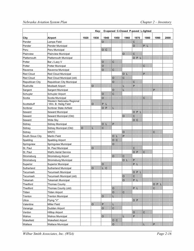
Please be specific and provide a source, if possible. Common requests were better instrumentation; indoor facilities at airports open later in the evening, and a statewide EMS. 6. How many beds does your facility have? How many physicians work out of your facility? Hospitals in Nebraska range in amount of beds from 13 to 390 beds. The average number of beds per hospital was 65. The number of physicians ranged from 1 to 890, with an average of 31 doctors at each facility. HISTORICAL AIRPORT DEVELOPMENT AND FUNDING The majority of development at public-use airports in Nebraska has been related to federally driven legislation and funding. It is important to note that while airport funding legislation is presented in the following discussion, the flow of funds for improvements to navigational aids does not typically correspond with the flow of funds for airport development. The reason for this is that navigational aids have typically used a separate funding stream, much like entitlements or money for annual operations. Table 2-16 depicts the history of Nebraska’s public-use airport sites in terms of when they opened or were closed, when the primary runway was paved, and if the runway was lighted. This history provides a snapshot of how the Nebraska airport system has developed over time.

Nebraska Aviation System Plan Chapter 2 – Inventory
Wilbur Smith Associates, Inc. (WSA) Page 2-13
Table 2-16 HISTORY OF NEBRASKA PUBLIC-USE AIRPORT SITES
Key: O-opened C-Closed P-paved L-lighted
City Airport 1920 1930 1940 1950 1960 1970 1980 1990 2000 Ainsworth Ainsworth Municipal O P L Ainsworth Ainsworth Municipal (old) O C Albion Albion Municipal O L P Albion Packard Flying O C Alliance Alliance Municipal O P L Alliance Alliance Municipal (old) O C Alma Alma Municipal O Alma Alma Municipal (old) O C Arapahoe Arapahoe Municipal O L P Arapahoe Arapahoe Municipal (old) O C Arapahoe ten Bensel Field O C Arcadia Arcadia Airport O C Arthur Arthur Municipal O Ashland H.J. Paul Airport O C Ashland Linoma Beach Airport O C Atkinson Stuart-Atkinson Municipal O L P Auburn Farington Field O L Aurora Aurora Municipal O L P Aurora Elge Airport O C Bassett Rock County O P L Bayard Bayard Municipal O C Beatrice Beatrice Municipal O P L Beaver City Hewetts Airports O C Benkelman Benkelman Airport O C Benkelman Jones Airport O C Big Springs Big Springs Municipal O L C Blair Blair Municipal O P L Blair Blair Municipal (old) O L P C Bloomfield Bloomfield Municipal O L P
Bradshaw Bradshaw Flying Service Airport O C
Brainard Brainard Municipal O C Bridgeport Bridgeport Municipal O C Broken Bow Broken Bow Municipal O L P Brule Brule Municipal O C Bruning Bruning State O P C Bruning Hawks Field O L C Burwell Cram Field O L P Callaway Callaway Municipal O C Cambridge Cambridge Municipal O L P Cambridge Medicine Creek Dam O C Cedar Rapids Cedar Rapids Municipal O C

Nebraska Aviation System Plan Chapter 2 – Inventory
Wilbur Smith Associates, Inc. (WSA) Page 2-14
Key: O-opened C-Closed P-paved L-lighted
City Airport 1920 1930 1940 1950 1960 1970 1980 1990 2000 Central City Central City Municipal O L P Central City Silver T Airport O C Chadron Chadron Municipal O L P Chadron O & N Airport O L C Chambers Perkins Memorial Airpark O Chappell Billy G Ray Field O L P Clay Center Clay Center Municipal O C Clearwater Clearwater Municipal O C Columbus Columbus Municipal O P L Cozad Cozad Municipal O L P Crawford Crawford Auxilliary O C Creighton Creighton Municipal O L P Crete Crete Municipal O L P Crofton K H Ranch Airport O C Curtis Curtis Municipal O L P David City David City Municipal O L P Decatur Eagleton Airport O C Enders Enders Dam O C Fairbury Fairbury Municipal O P L Fairmont Fairmont State Airfield O P L Falls City Brenner Field O L P Fremont Fremont Municipal O P L Fullerton C.A.M.P. O C Genoa Genoa Municipal O Gordon Gordon Municipal O P L Gothenburg Quinn Field O P L Grand Island Central Nebraska Regional O P L Grand Island Roush Airport O C Grant Grant Municipal O L P Grant Pankonin Airport O L C Greeley Greeley Municipal O Harrison Harrison Skyranch O Hartington Hartington Municipal O L P Harvard Harvard State Airfield O P L Hastings Hastings Municipal O P L Hay Springs Hay Springs Municipal O L Hayes Center Hayes Center Municipal O C Hebron Hebron Municipal O L P Holdrege Brewster Field O L P Humboldt Humboldt Municipal O L C Hyannis Grant County O L P Imperial Imperial Municipal O P L Kearney Kearney Municipal O L P Kimball Kimball Municipal (Old) O C Kimball Robert E. Arraj Field O L P Laurel Laurel Municipal O C Lexington Jim Kelly Field O L P

Nebraska Aviation System Plan Chapter 2 – Inventory
Wilbur Smith Associates, Inc. (WSA) Page 2-15
Key: O-opened C-Closed P-paved L-lighted
City Airport 1920 1930 1940 1950 1960 1970 1980 1990 2000 Lincoln Arrow Airport O L P C Lincoln Lincoln Municipal O P L Lincoln Union Air Terminal O P L C Lodgepole Lodgepole Municipal O C Long Pine Long Pine Auxilliary O C Lorenzo Lorenzo Airport O C Loup City Loup City Municipal O P L Lynch Woolf Bros. Airport O C McCook McCook Municipal (old) O C McCook McCook Municipal O P L McCook McCook State O P C Mead Univ. of Nebr. Field Lab O C Merriman Cole Memorial O P C Minatare Minatare Airport O C Minden Pioneer Village Field O L P Mitchell Mitchell Municipal O C Mullen Hooker County O P Nebraska City Grundman Airport O L P C Nebraska City Nebraska City Municipal O P L Nebraska City Roll Brothers O C Neligh Antelope County O P L Nelson Doher Airstrip O C Norfolk Karl Stefan Memorial O P L Norfolk Simpson O C North Platte Clinch O C North Platte North Platte Regional O L P Oakdale Wagner's Airport O C Oakland Dinklage Airport O C Ogallala Lake McConaughy State O L C Ogallala Searle Field O P L Ogallala Shelburne O C Ohiowa Sieber's Airport O C Omaha Clear Ridge Airport O P C Omaha Durand Skyranch O C Omaha Eppley Airfield O P L Omaha Millard Airport O P L Omaha North Omaha O L P Omaha South Omaha O L C
O'Neill O'Neill Municipal - John L. Baker Field O P L
Ord Evelyn Sharp Field O L P Orleans Ott Flying Service O C Oshkosh Garden County O P L Overton Overton Municipal O C Oxford Oxford Municipal O C Pawnee City Pawnee City Municipal O L Paxton Lierley Airport O C
Nebraska Aviation System Plan Chapter 2 – Inventory
Wilbur Smith Associates, Inc. (WSA) Page 2-16
Key: O-opened C-Closed P-paved L-lighted
City Airport 1920 1930 1940 1950 1960 1970 1980 1990 2000 Pender Lampe Field O C Pender Pender Municipal O P L Peru Peru Municipal O C Plainview Plainview Municipal O C Plattsmouth Plattsmouth Municipal O P L Potter Bar J Lazy V O C Potter Potter Municipal O C Ravenna Ravenna Municipal O C Red Cloud Red Cloud Municipal O L P Red Cloud Red Cloud Municipal (old) O C Republican City Republican City Municipal O C Rushville Modisett Airport O L P Sargent Sargent Municipal O L P Schuyler Schuyler Airport O C Scotia Scotia Municipal O C
Scottsbluff Western Nebraska Regional / Wm. B. Heilig Field O P L
Scribner Scribner State Airfield O P L Seward Seward Municipal O P L Seward Seward Municipal (Old) O C Seward Wide Sky O C Sidney Sidney Municipal O L P Sidney Sidney Municipal (Old) O L C Sidney WNTC O C South Sioux City Martin Field O L P Spalding Spalding Airport O C Springview Springview Municipal O St. Paul St. Paul Municipal O C St. Paul Walt's Aerial Service O P C Stromsburg Stromsburg Airport O C Stromsburg Stromsburg Municipal O L P Superior Superior Municipal O P L Sutherland Sutherland Municipal O L C Tecumseh Tecumseh Municipal O P L Tecumseh Tecumseh Municipal (old) O C Tekamah Tekamah Municipal O P L Thedford Thomas County O P L Thedford Thomas County (old) O P L C Tilden Tilden Airport O C Trenton Trenton Municipal O L Utica Flying "V" O P Valentine Miller Field O P L Venango Dudden Airport O C Verdon Hilltop Airport O C Wahoo Wahoo Municipal O L P Wakefield Wakefield Airport O C Wallace Wallace Municipal O L P

Nebraska Aviation System Plan Chapter 2 – Inventory
Wilbur Smith Associates, Inc. (WSA) Page 2-17
Key: O-opened C-Closed P-paved L-lighted
City Airport 1920 1930 1940 1950 1960 1970 1980 1990 2000 Wayne Wayne Municipal O L P Weeping Water Browns Airport O Weissert Weissert Airport O C West Point Knievel O C Wilber Wilber Municipal O Wisner Heller Air Ranch O C Wisner Wisner Airport O C York York Municipal O P L York York Municipal (old) O L P C Cumulative Totals Airports Opened During the Decade 11 25 65 44 24 15 2 3 0 Airports Closed During the Decade 0 3 11 27 12 17 17 11 1 Total Number Public-Use Airports 11 33 87 104 116 114 99 91 90 Number Paved 0 3 20 31 48 71 74 79 78 Number Lighted 0 11 21 54 71 81 81 81 80
Source: Nebraska Department of Aeronautics (revised December 26, 2001) The time periods of airport development funding programs are outlined below with additional information regarding national and state aviation development: 1926-1932 The Air Commerce Act of 1926 provided for aeronautical facilities, but no funding for
airports. The Air Mail (Kelly) Act of 1925 provided funding to contractors to fly the mail. These companies, including the Boeing Air Transport Company, serving most of Nebraska, made arrangements with local airports for facilities. This resulted in an indirect flow of federal funds to establish airport facilities.
Airports were established in many Nebraska communities to serve the transcontinental air mail route, which stretched from Chicago to San Francisco with stops in Omaha, North Platte, and various intermediate fields along the route. An interesting note is that some cities such as Big Springs, Sutherland and Overton had auxiliary fields that were eventually closed, while others such as Lincoln and Ogallala remain to this day. A publication entitled “Airports and Established Landing Fields,” produced in 1934 by The Airport Directory Company, listed 23 municipal or auxiliary fields. A few of these airports such as Hastings, Ogallala and Norfolk were located on the sites they now occupy to this day. Many others were to be interim locations in their community until moved to their present location such as Alliance, McCook, and Sidney. 1933-1939 In 1933, the Airport Development Program was created with the help of the Civil Works
Administration. Beginning in 1935, the Works Progress Administration (WPA) began to assist the airport development efforts. The 1938 Civil Aeronautics Act included funding for airports. From a national standpoint, there were 823 municipal airports in 1927 and 1,833 in 1938 as a result of the federal relief program. In 1939, there were only 69,729 pilots in the nation.

Nebraska Aviation System Plan Chapter 2 – Inventory
Wilbur Smith Associates, Inc. (WSA) Page 2-18
By 1939, an airways navigational aid network was completed including 231 radio range stations. Nebraska participated in a program of air-marking towns to provide pilots a visual aid to navigation. The marking was done on a large roof in towns and consisted of the name of the town, an arrow, and distance to the nearest airport. The marking was discontinued during the war, but resumed in the late 1940s and continued into the 1950s. In a 1938 WPA-directed plan, Nebraska listed 31 existing airports and a network of visual and electronic navigational aids such as air-marked towns and radio range stations. The Department of Aeronautics records show that by the end of the 1930s Nebraska had 33 public-use airports, three of which were paved and 11 lighted. In addition, three were either converted to private-use or closed by the end of the decade. 1940-1944 Two programs were created for airport development for the purpose of national defense
and training civilian pilots. Over this period, the programs provided $392 million for 564 airport projects. The programs were the Development of Landing Areas for National Defense (DLAND) and Development of Civilian Landing Areas (DCLA). The funding came from appropriations to the Civil Aeronautics Authority with construction work carried out through the WPA, War, and Navy departments. In addition, the Civilian Pilot Training Program existed from 1938 until 1944 (name changed to War Training Service in 1942) and was credited with training over 300,000 pilots. By 1944, there were 181,378 licensed pilots in the nation.
Navigational aids were improving with the development of the Instrument Landing System (ILS) in 1940 and experiments with VHF Omnidirectional Ranges (VOR) in 1941. Based on these developments, approach minimums began to be lowered in 1947. In Nebraska, there were 12 airfields constructed to train troops for World War II. These included facilities at Ainsworth, Alliance, Bruning, Fairmont, Grand Island, Harvard, Kearney, Lincoln, McCook, Omaha (Fort Crook), Scottsbluff, and Scribner. Omaha (Fort Crook) is now Offutt Air Force Base and Bruning and McCook were eventually closed. All other facilities continue to be the principle airports serving these communities. In addition, the WPA directed other airport projects in Nebraska including Beatrice, Fremont, Chadron, Norfolk, North Platte, Clay Center, Hastings, and Omaha. During the 1940s, 65 Nebraska public-use airports opened, while 11 were either converted to private-use or closed. Initial runway paving was completed at 17 airports and initial lighting was installed at 13 airports. 1947-1970 In 1946, the Federal Aid Airport Program (FAAP) was created and authorized for seven
years with $525 million authorized. Nationwide by 1969 there were 6,710 public-use airports. 3,684 of these, or 55 percent, were publicly owned, while the remaining 45 percent were privately owned. By 1947, licensed pilots in the nation jumped to 433,241 and by 1970, that number was 732,729. In 1960, 18 percent of pilots were instrument rated and by 1970, 23 percent were instrument rated.
In 1947, VORs began to replace radio range stations and by 1950, the first VOR ‘Victor’ Airway was established. In 1955, Nebraska became the first state to install and maintain VORs to supplement federal navigational aids. The first three installations were at Alliance, Ainsworth, and Norfolk. In 1959,

Nebraska Aviation System Plan Chapter 2 – Inventory
Wilbur Smith Associates, Inc. (WSA) Page 2-19
Nebraska added ‘H’ (Homer) beacons, later known as Non-Directional Beacons (NDB) to further enhance the airways system in the State. In the 1950s and 1960s, 68 Nebraska public-use airports were opened and 39 were either converted to private-use or closed. Initial runway paving was completed at 31 airports and initial lighting was installed at 52 airports. 1971-1981 In 1970, the Airport Development Aid Program (ADAP) and Planning Grant Program
were created to provide grants for airport projects. In addition, the Airport and Airway Trust Fund was created. By 1981, there were 5,846 public-use airports in the nation. 3,995 of these airports, or 68 percent were publicly owned and the remaining 32 percent were privately owned. The number of licensed pilots in the nation reached an all-time high of 827,071 in 1980 and then began a slow decline in 1981, recording 764,182.
In the 1970s, 15 new public-use airports were opened in Nebraska and 17 were either converted to private-use or closed. 24 airports had their runways initially paved and 12 airports were initially lighted. 1982-2000 In 1982, the Airport Improvement Program (AIP) was created and has been subsequently
reauthorized numerous times through the present. By 2000, there were 5,041 public-use airports in the nation. 4,016, or 79 percent, were publicly owned and the remaining 21 percent were privately owned. During this time, the licensed pilots dropped to a low of 616,342 in 1997 and by 2000, 625,581 were recorded. Of the total pilots, 50 percent are instrument rated.
Beginning in 1978, the FAA began testing a replacement to ILS and chose the Microwave Landing System (MLS). Due to rapid technological advances, the FAA has since terminated that plan and chosen a system using the Global Positioning System (GPS) as the future basis for en route and approach navigational aids. The ILS, VOR, and NDB systems remain in place until the GPS is certified as fully operational for the necessary approach minimums. In 1989, the FAA and National Weather Service (NWS) began installation of Automated Surface Observation Systems (ASOS) and Automated Weather Observation Systems (AWOS), which are essentially the same type of systems, to analyze and report surface weather conditions. This system eventually replaced the human observer at airports. Nebraska began installation of AWOS systems in 1991 as a supplement to the federal system.

Table 2-1AIRPORT OWNERSHIP
Page 1 of 2
FAAAssociated Site FAA NPIAS
City Airport Name Number ID Ownership StatusAinsworth Ainsworth Municipal Airport 12591.A ANW PUBLIC GAAlbion Albion Municipal Airport 12594.1A BVN PUBLIC GAAlliance Alliance Municipal Airport 12597.A AIA PUBLIC GAAlma Alma Municipal Airport 12598.A 4D9 PUBLIC GAArapahoe Arapahoe Municipal Airport 12608.01A 37V PUBLICArthur Arthur Municipal Airport 12611.A 38V PUBLICAtkinson Stuart-Atkinson Municipal Airport 12614.11A 8V2 PUBLIC GAAuburn Farington Field 12621.A K01 PUBLIC GAAurora Aurora Municipal Airport 12623.1A AUH PUBLIC GABassett Rock County Airport 12623.9A RBE PUBLIC GABeatrice Beatrice Municipal Airport 12629.A BIE PUBLIC GABlair Blair Municipal Airport 12853.2A K46 PUBLIC GABloomfield Bloomfield Municipal Airport 12648.A 84Y PUBLICBroken Bow Broken Bow Municipal Airport 12659.A BBW PUBLIC GABurwell Cram Field 12668.A BUB PUBLIC GACambridge Cambridge Municipal Airport 12669.9A CSB PUBLIC GACentral City Central City Municipal Airport 12671.2A 07K PUBLIC GAChadron Chadron Municipal Airport 12674.A CDR PUBLIC GAChambers Perkins Memorial Airport 12675.A 88Y PUBLICChappell Billy G Ray Field 12677.1A CNP PUBLIC GAColumbus Columbus Municipal Airport 12681.A OLU PUBLIC GACozad Cozad Municipal Airport 12684.A CZD PUBLIC GACreighton Creighton Municipal Airport 12693.A 6K3 PUBLIC GACrete Crete Municipal Airport 12694.A CEK PUBLIC GACurtis Curtis Municipal Airport 12697.A 47V PUBLIC GADavid City David City Municipal Airport 12699.A 93Y PUBLIC GAFairbury Fairbury Municipal Airport 12704.A FBY PUBLIC GAFairmont Fairmont State Airfield 12705.A FMZ PUBLIC GAFalls City Brenner Field 12707.1A FNB PUBLIC GAFremont Fremont Municipal Airport 12716.A FET PUBLIC GAGenoa Genoa Municipal Airport 12729.5A 97Y PUBLICGordon Gordon Municipal Airport 12736.A GRN PUBLIC GAGothenburg Quinn Field 12741.A GTE PUBLICGrand Island Central Nebraska Regional Airport 12743.A GRI PUBLIC PRGrant Grant Municipal Airport 12748.A GGF PUBLIC GAGreeley Greeley Municipal Airport 12748.32A 99Y PUBLIC GAHarrison Harrison Skyranch 12751.4A 9V3 PUBLICHartington Hartington Municipal Airport 12752.4A 0B4 PUBLIC GAHarvard Harvard State Airfield 12753.A 08K PUBLIC GAHastings Hastings Municipal Airport 12755.A HSI PUBLIC GAHay Springs Hay Springs Municipal Airport 12759.1A 4V6 PUBLICHebron Hebron Municipal Airport 12761.A HJH PUBLIC GAHoldrege Brewster Field 12766.A HDE PUBLIC GAHyannis Grant County Airport 12774.4A 1V2 PUBLIC GAImperial Imperial Municipal Airport 12776.A IML PUBLIC GAKearney Kearney Municipal Airport 12783.A EAR PUBLIC CMKimball Robert E. Arraj Field 12785.2A IBM PUBLIC GALexington Jim Kelly Field 12790.A LXN PUBLIC GALincoln Lincoln Municipal Airport 12794.A LNK PUBLIC PRLoup City Loup City Municipal Airport 12805.22A 0F4 PUBLIC GAMcCook McCook Municipal Airport 12808.A MCK PUBLIC GAMinden Pioneer Village Field 12817.A 0V3 PUBLIC GA

Table 2-1AIRPORT OWNERSHIP
Page 2 of 2
FAAAssociated Airport Site FAA NPIAS
City Airport Name Number ID Ownership StatusMullen Hooker County Airport 12823.1A MHN PUBLICNebraska City Nebraska City Municipal Airport 12824.11A AFK PUBLIC GANeligh Antelope County Airport 12826.A 4V9 PUBLIC GANorfolk Karl Stefan Memorial Airport 12836.A OFK PUBLIC GANorth Platte North Platte Regional Airport 12842.A LBF PUBLIC CMOgallala Searle Field 12848.A OGA PUBLIC GAOmaha Eppley Airfield 12854.A OMA PUBLIC PROmaha Millard Airport 12855.14A MLE PUBLIC RLOmaha North Omaha Airport 12855.A 3NO PRIVATEO'Neill O'Neill Muni.-John L. Baker Field 12856.A ONL PUBLIC GAOrd Evelyn Sharp Field 12861.A ODX PUBLIC GAOshkosh Garden County Airport 12865.A OKS PUBLIC GAPawnee City Pawnee City Municipal Airport 12874.9A 50K PUBLIC GAPender Pender Municipal Airport 12878.1A 0C4 PUBLIC GAPlattsmouth Plattsmouth Municipal Airport 12889.2A PMV PUBLIC GARed Cloud Red Cloud Municipal Airport 12895.1A 7V7 PUBLIC GARushville Modisett Field 12902.A 9V5 PUBLIC GASargent Sargent Municipal Airport 12911.A 09K PUBLIC GAScottsbluff Western Nebraska Regional / Wm. B. Heilig 12915.A BFF PUBLIC PRScribner Scribner State Airfield 12917.A SCB PUBLIC GASeward Seward Municipal Airport 12920.12A SWT PUBLIC GASidney Sidney Municipal Airport 12927.A SNY PUBLIC GASouth Sioux City Martin Field 12928.5A 7K8 PRIVATESpringview Springview Municipal Airport 12931.A 9V1 PUBLICStromsburg Stromsburg Municipal Airport 12934.8A 11K PUBLICSuperior Superior Municipal Airport 12940.A 12K PUBLIC GATecumseh Tecumseh Municipal Airport 12944.01A 0G3 PUBLIC GATekamah Tekamah Municipal Airport 12946.1A TQE PUBLIC GAThedford Thomas County Airport 12951.11A 6N8 PUBLIC GATrenton Trenton Municipal Airport 12953.A 9V2 PUBLICUtica Flying "V" Airport 12958.1A 0J9 PRIVATEValentine Miller Field 12960.A VTN PUBLIC GAWahoo Wahoo Municipal Airport 12964.A AHQ PUBLIC GAWallace Wallace Municipal Airport 12966.A 64V PUBLICWayne Wayne Municipal Airport 12974.A LCG PUBLIC GAWeeping Water Browns Airport 12977.A EPG PRIVATEWilber Wilber Municipal Airport 12984.A 0D6 PUBLICYork York Municipal Airport 12993.01A JYR PUBLIC GASource: Nebraska Department of Aeronautics, Wilbur Smith Associates

Table 2-2AIRSIDE FACILITIES - PRIMARY RUNWAY
Page 1 of 2
Primary Primary Primary Primary Primary Primary Primary Primary PrimaryAssociated Runway Runway Runway Runway Runway Runway Taxiway Taxiway Taxiway
City Airport Name Designation Length Width Surface Strength Lighting Configuration Width LightingAinsworth Ainsworth Municipal Airport 17/35 6800 110 ASPH 30 MED FULL PARALLEL 35 LOWAlbion Albion Municipal Airport 15/33 3700 60 CONC 12 MED PARTIAL PARALLEL 25 MEDAlliance Alliance Municipal Airport 12/30 9203 150 ASPH 36 MED FULL PARALLEL 35 MEDAlma Alma Municipal Airport 17/35 3280 120 TURF 0 CONNECTING TURFArapahoe Arapahoe Municipal Airport 15/33 3000 50 ASPH 6 MED CONNECTING 25Arthur Arthur Municipal Airport 06/24 2700 200 TURF 0Atkinson Stuart-Atkinson Municipal Airport 11/29 4075 50 ASPH 4 LOW CONNECTING 25Auburn Farington Field 15/33 4000 100 TURF 0 MED CONNECTING TURF MEDAurora Aurora Municipal Airport 16/34 4301 75 ASPH 12 MED FULL PARALLEL 30 MEDBassett Rock County Airport 13/31 4700 75 CONC 30 MED CONNECTING 35 MEDBeatrice Beatrice Municipal Airport 17/35 5601 100 ASPH/CONC 39 MED FULL PARALLEL 35 MEDBlair Blair Municipal Airport 13/31 3450 50 ASPH 25 LOW FULL PARALLELBloomfield Bloomfield Municipal Airport 14/32 2700 50 ASPH 10 LOW CONNECTING 20Broken Bow Broken Bow Municipal Airport 14/32 4203 75 CONC 30 MED CONNECTING 30 MEDBurwell Cram Field 15/33 3212 50 ASPH 10 MED CONNECTING 20 MEDCambridge Cambridge Municipal Airport 14/32 4099 60 ASPH 12 MED PARTIAL PARALLEL 30 MEDCentral City Central City Municipal Airport 15/33 2900 50 ASPH 11 LOW CONNECTING (2) 30Chadron Chadron Municipal Airport 02/20 6002 100 CONC 32 High PARTIAL PARALLEL 35 MEDChambers Perkins Memorial Airport 17/35 2400 200 TURF 0Chappell Billy G Ray Field 12/30 4000 55 ASPH 12 MED CONNECTING 30 MEDColumbus Columbus Municipal Airport 14/32 5681 100 ASPH/CONC 36 MED FULL PARALLEL 50 MEDCozad Cozad Municipal Airport 13/31 4200 75 CONC 30 MED CONNECTING 25 MEDCreighton Creighton Municipal Airport 12/30 3100 50 ASPH 12 LOW CONNECTING 30Crete Crete Municipal Airport 17/35 4201 75 CONC 30 MED PARTIAL PARALLEL 35 MEDCurtis Curtis Municipal Airport 12/30 3400 60 ASPH 12 LOW CONNECTING 30 LOWDavid City David City Municipal Airport 14/32 3100 50 ASPH 12 LOW CONNECTING 25Fairbury Fairbury Municipal Airport 17/35 3700 75 CONC 12 MED CONNECTING 35 MEDFairmont Fairmont State Airfield 17/35 4300 75 ASPH 12 MED FULL PARALLEL 30 REFLECTORFalls City Brenner Field 14/32 3999 60 CONC 30 MED PARTIAL PARALLEL 35Fremont Fremont Municipal Airport 13/31 5500 100 ASPH/CONC 28 MED FULL PARALLEL 35 MEDGenoa Genoa Municipal Airport 11/29 2500 80 TURF 0Gordon Gordon Municipal Airport 04/22 5200 75 ASPH 12 MED PARTIAL PARALLEL 30 MEDGothenburg Quinn Field 03/21 2598 50 CONC 28 MED CONNECTING 30Grand Island Central Nebraska Regional Airport 17/35 7001 150 ASPH 65 HIGH FULL PARALLEL 75 MEDGrant Grant Municipal Airport 15/33 3800 50 ASPH 16 LOW CONNECTING 30Greeley Greeley Municipal Airport 13/31 2800 100 TURF 0Harrison Harrison Skyranch 12/30 2800 120 TURF 0 LOW CONNECTINGHartington Hartington Municipal Airport 13/31 3950 60 CONC 12 MED CONNECTING 25 MEDHarvard Harvard State Airfield 17/35 3745 60 ASPH 12 MED PARTIAL PARALLEL 25Hastings Hastings Municipal Airport 14/32 6450 100 CONC 36 MED FULL PARALLEL 35 MEDHay Springs Hay Springs Municipal Airport 11/29 2750 300 TURF 0 MEDHebron Hebron Municipal Airport 12/30 3600 60 CONC 30 MED CONNECTING 30 MEDHoldrege Brewster Field 18/36 4700 75 ASPH/CONC 30 MED FULL PARALLEL 30 MEDHyannis Grant County Airport 17/35 3975 50 ASPH 12 MED CONNECTING 25Imperial Imperial Municipal Airport 13/31 5022 100 CONC 30 MED CONNECTING 35 REFLECTORSKearney Kearney Municipal Airport 18/36 7094 150 ASPH 48 HIGH FULL PARALLEL 35 MEDKimball Robert E. Arraj Field 10/28 6199 75 CONC 30 MED PARTIAL PARALLEL 35 MEDLexington Jim Kelly Field 14/32 5500 100 CONC 30 MED PARTIAL PARALLEL 35 MEDLincoln Lincoln Municipal Airport 17R/35L 12901 200 ASPH/CONC 100 HIGH FULL PARALLEL 75 MEDLoup City Loup City Municipal Airport 15/33 3200 50 ASPH 8 LOW CONNECTING 30 LOWMcCook McCook Municipal Airport 12/30 6448 100 CONC 30 MED FULL PARALLEL 35 MEDMinden Pioneer Village Field 16/34 3900 60 CONC 30 MED Partial Parallel 30 MEDMullen Hooker County Airport 09/27 2525 25 ASPH 4Nebraska City Nebraska City Municipal Airport 15/33 4500 75 CONCRETE 30 MED CONNECTING 35 MED

Table 2-2AIRSIDE FACILITIES - PRIMARY RUNWAY
Page 2 of 2
Primary Primary Primary Primary Primary Primary Primary Primary PrimaryAssociated Runway Runway Runway Runway Runway Runway Taxiway Taxiway Taxiway
City Airport Name Designation Length Width Surface Strength Lighting Configuration Width LightingNeligh Antelope County Airport 12/30 3300 50 ASPH 5 LOW CONNECTING 30Norfolk Karl Stefan Memorial Airport 01/19 5800 100 ASPH 60 HIGH FULL PARALLEL 35 MEDNorth Platte North Platte Regional Airport 12/30 8000 150 CONC 75 HIGH FULL PARALLEL 35 MEDOgallala Searle Field 08/26 4502 75 ASPH 12 MED CONNECTING 40 MEDOmaha Eppley Airfield 14R/32L 9502 150 ASPH/CONC 100 HIGH FULL PARALLEL 75 MEDOmaha Millard Airport 12/30 3800 75 CONC 12 MED FULL PARALLEL 40 MEDOmaha North Omaha Airport 17/35 2480 40 CONC 28 NSTD FULL PARALLEL NSTDO'Neill O'Neill Muni.-John L. Baker Field 13/31 4400 75 ASPH 12 MED PARTIAL PARALLEL 40 MEDOrd Evelyn Sharp Field 13/31 4500 60 CONC 30 MED CONNECTING 25 MEDOshkosh Garden County Airport 12/30 3700 50 CONC 12 LOW PARTIAL PARELLEL 30 LOWPawnee City Pawnee City Municipal Airport 14/32 3375 125 TURF 0 LOWPender Pender Municipal Airport 15/33 3600 60 CONC 30 MED CONNECTING (2) 25Plattsmouth Plattsmouth Municipal Airport 16/34 4100 100 CONC 30 MED FULL PARALLEL 35 MEDRed Cloud Red Cloud Municipal Airport 15/33 3700 60 CONC 12 LOW CONNECTING 30Rushville Modisett Field 14/32 3900 60 ASPH 12 MED CONNECTING 30 MEDSargent Sargent Municipal Airport 16/34 3000 50 ASPH 10 MED CONNECTING 25 MEDScottsbluff Western Nebraska Regional / Wm. B. Heilig 12/30 8280 150 ASPH 75 HIGH FULL PARALLEL 35 MEDScribner Scribner State Airfield 17/35 4200 75 CONC 30 MED FULL PARALLEL 25 MEDSeward Seward Municipal Airport 16/34 3601 60 CONC 30 MED CONNECTING 30 MEDSidney Sidney Municipal Airport 12/30 6601 100 CONC 32 HIGH PARTIAL PARALLEL MEDSouth Sioux City Martin Field 14/32 3281 22 ASPH 0 LOW PARALLELSpringview Springview Municipal Airport 13/31 2200 200 TURF 0Stromsburg Stromsburg Municipal Airport 02/20 2210 21 ASPH 12 LOWSuperior Superior Municipal Airport 14/32 3702 60 ASPH/CONC 12 LOW CONNECTING 30Tecumseh Tecumseh Municipal Airport 15/33 3500 75 ASPH 6 MED CONNECTING 40Tekamah Tekamah Municipal Airport 14/32 4001 75 CONC 30 MED CONNECTING 35 LOWThedford Thomas County Airport 11/29 3600 50 ASPH 12 MED CONNECTING 25 MEDTrenton Trenton Municipal Airport 14/32 2360 280 TURF 0 MEDUtica Flying "V" Airport 17/35 3000 50 CONC 12 LOW CONNECTINGValentine Miller Field 14/32 4700 100 ASPH 12 MED CONNECTING 40 MEDWahoo Wahoo Municipal Airport 02/20 4100 75 CONC 30 MED PARTIAL PARALLEL 35 MEDWallace Wallace Municipal Airport 13/31 2800 50 ASPH 0 NSTDWayne Wayne Municipal Airport 17/35 4200 75 ASPH 12 MED CONNECTING 35 MEDWeeping Water Browns Airport 17/35 2200 60 TURF/GRVL 0Wilber Wilber Municipal Airport 18/36 2345 300 TURF 0York York Municipal Airport 17/35 5900 100 CONC 30 MED PARTIAL PARALLEL 35 MEDSource: Nebraska Department of Aeronautics, Wilbur Smith Associates

Table 2-3AIRSIDE FACILITIES - SECONDARY RUNWAY
Page 1 of 2
Secondary Secondary Secondary Secondary Secondary Secondary Secondary Secondary SecondaryAssociated Runway Runway Runway Runway Runway Runway Taxiway Taxiway Taxiway
City Airport Name Designation Length Width Surface Strength Lighting Configuration Width LightingAinsworth Ainsworth Municipal Airport 12/30 5500 75 ASPH 25 CONNECTING 35Albion Albion Municipal Airport - - - - - - - - -Alliance Alliance Municipal Airport 08/26 6200 75 ASPH 36 MED PARALLEL 35 MEDAlma Alma Municipal Airport - - - - - - - - -Arapahoe Arapahoe Municipal Airport - - - - - - - - -Arthur Arthur Municipal Airport - - - - - - - - -Atkinson Stuart-Atkinson Municipal Airport 5/23 3000 300 TURFAuburn Farington Field 02/20 1400 80 TURFAurora Aurora Municipal Airport - - - - - - - - -Bassett Rock County Airport 02/20 2210 120 TURFBeatrice Beatrice Municipal Airport 13/31 4401 100 ASPH 39 MED CONNECTING 50 MEDBlair Blair Municipal Airport 18/36 1135 75 TURFBloomfield Bloomfield Municipal Airport - - - - - - - - -Broken Bow Broken Bow Municipal Airport - - - - - - - - -Burwell Cram Field - - - - - - - - -Cambridge Cambridge Municipal Airport - - - - - - - - -Central City Central City Municipal Airport - - - - - - - - -Chadron Chadron Municipal Airport 11/29 4405 100 ASPH 21 MEDChambers Perkins Memorial Airport - - - - - - - - -Chappell Billy G Ray Field - - - - - - - - -Columbus Columbus Municipal Airport 02/20 4135 150 TURFCozad Cozad Municipal Airport - - - - - - - - -Creighton Creighton Municipal Airport 18/36 2100 200 TURFCrete Crete Municipal Airport 13/31 3370 150 TURFCurtis Curtis Municipal Airport 17/35 2200 290 TURFDavid City David City Municipal Airport 01/19 2100 120 TURFFairbury Fairbury Municipal Airport 11/29 2455 150 TURFFairmont Fairmont State Airfield 12/30 3011 60 CONC 12 CONNECTING 25Falls City Brenner Field - - - - - - - - -Fremont Fremont Municipal Airport 18/36 2444 50 ASPH 36 CONNECTING 50 MEDGenoa Genoa Municipal Airport - - - - - - - - -Gordon Gordon Municipal Airport 11/29 2280 50 ASPH 12 MEDGothenburg Quinn Field 14/32 3300 250 TURF LOWGrand Island Central Nebraska Regional Airport 13/31 6608 150 ASPH 52 MED CONNECTING 75 MEDGrant Grant Municipal Airport - - - - - - - - -Greeley Greeley Municipal Airport - - - - - - - - -Harrison Harrison Skyranch - - - - - - - - -Hartington Hartington Municipal Airport 03/21 2150 125 TURFHarvard Harvard State Airfield 14/32 3900 150 TURF CONNECTING 40 REFLECTRHastings Hastings Municipal Airport 04/22 4500 75 CONC 36 MED PARALLEL 40 MEDHay Springs Hay Springs Municipal Airport - - - - - - - - -Hebron Hebron Municipal Airport 03/21 2532 150 TURFHoldrege Brewster Field 11/29 2965 300 TURFHyannis Grant County Airport - - - - - - - - -Imperial Imperial Municipal Airport 03/21 3058 300 TURFKearney Kearney Municipal Airport 13/31 4497 75 CONC 30 MED FULL PARALLEL 35 MEDKimball Robert E. Arraj Field - - - - - - - - -Lexington Jim Kelly Field 01/19 3200 250 TURF LOWLincoln Lincoln Municipal Airport 14/32 8649 150 ASPH/CONC 80 MED FULL PARALLEL 75 MEDLoup City Loup City Municipal Airport 04/22 2100 100 TURFMcCook McCook Municipal Airport 03/21 4000 75 CONC 30 MED FULL PARALLEL 35 MEDMinden Pioneer Village Field 05/23 1600 300 TURFMullen Hooker County Airport - - - - - - - - -Nebraska City Nebraska City Municipal Airport - - - - - - - - -

Table 2-3AIRSIDE FACILITIES - SECONDARY RUNWAY
Page 2 of 2
Secondary Secondary Secondary Secondary Secondary Secondary Secondary Secondary SecondaryAssociated Runway Runway Runway Runway Runway Runway Taxiway Taxiway Taxiway
City Airport Name Designation Length Width Surface Strength Lighting Configuration Width LightingNeligh Antelope County Airport 18/36 2000 150 TURFNorfolk Karl Stefan Memorial Airport 13/31 5800 100 ASPH 60 MED PARALLEL 35 MEDNorth Platte North Platte Regional Airport 17/35 4436 100 ASPH 28 MED CONNECTING 100 MEDOgallala Searle Field 13/31 3698 50 ASPH 6 MED CONNECTING 40Omaha Eppley Airfield 18/36 8153 150 ASPH/CONC 150 HIGH FULL PARALLEL 75 MEDOmaha Millard Airport - - - - - - - - -Omaha North Omaha Airport - - - - - - - - -O'Neill O'Neill Muni.-John L. Baker Field 04/22 3030 60 TURFOrd Evelyn Sharp Field 17/35 2086 300 TURFOshkosh Garden County Airport - - - - - - - - -Pawnee City Pawnee City Municipal Airport - - - - - - - - -Pender Pender Municipal Airport - - - - - - - - -Plattsmouth Plattsmouth Municipal Airport - - - - - - - - -Red Cloud Red Cloud Municipal Airport - - - - - - - - -Rushville Modisett Field - - - - - - - - -Sargent Sargent Municipal Airport - - - - - - - - -Scottsbluff Western Nebraska Regional / Wm. B. Heilig 05/23 8002 150 ASPH 36 MED PARTIAL PARALLEL 55 MEDScribner Scribner State Airfield 12/30 2800 60 CONC 12 CONNECTING 25 REFLSeward Seward Municipal Airport 04/22 3400 150 TURFSidney Sidney Municipal Airport 02/20 4700 75 TURFSouth Sioux City Martin Field - - - - - - - - -Springview Springview Municipal Airport - - - - - - - - -Stromsburg Stromsburg Municipal Airport - - - - - - - - -Superior Superior Municipal Airport 18/36 3000 200 TURFTecumseh Tecumseh Municipal Airport - - - - - - - - -Tekamah Tekamah Municipal Airport - - - - - - - - -Thedford Thomas County Airport - - - - - - - - -Trenton Trenton Municipal Airport 01/19 2260 300 TURFUtica Flying "V" Airport - - - - - - - - -Valentine Miller Field 02/20 2807 50 ASPH 12 MED CONNECTING 30Wahoo Wahoo Municipal Airport 13/31 3280 150 TURF LOWWallace Wallace Municipal Airport - - - - - - - - -Wayne Wayne Municipal Airport 04/22 3407 60 ASPH 8 MED CONNECTING 40 MEDWeeping Water Browns Airport 11/29 1400 50 TURF/GRVLWilber Wilber Municipal Airport 14/32 2150 300 TURFYork York Municipal Airport 05/23 4700 150 TURFSource: Nebraska Department of Aeronautics, Wilbur Smith Associates

Table 2-4TERMINAL BUILDING SIZE
Page 1 of 2
Air GeneralCarrier Aviation
Associated Terminal TerminalCity Airport Name (Sq Ft) (Sq Ft)
Ainsworth Ainsworth Municipal Airport 0 1,008Albion Albion Municipal Airport 0 300Alliance Alliance Municipal Airport 8,500 903Alma Alma Municipal Airport 0 0Arapahoe Arapahoe Municipal Airport 0 0Arthur Arthur Municipal Airport 0 0Atkinson Stuart-Atkinson Municipal Airport 0 300Auburn Farington Field 0 300Aurora Aurora Municipal Airport 0 2,000Bassett Rock County Airport 0 500Beatrice Beatrice Municipal Airport 0 1,280Blair Blair Municipal Airport 0Bloomfield Bloomfield Municipal Airport 0 300Broken Bow Broken Bow Municipal Airport 0 1,600Burwell Cram Field 0 250Cambridge Cambridge Municipal Airport 0 400Central City Central City Municipal Airport 0 3,000Chadron Chadron Municipal Airport 1,915 360Chambers Perkins Memorial Airport 0 0Chappell Billy G Ray Field 0 0Columbus Columbus Municipal Airport 0 2,100Cozad Cozad Municipal Airport 0 1,000Creighton Creighton Municipal Airport 0 400Crete Crete Municipal Airport 0 3,200Curtis Curtis Municipal Airport 0 960David City David City Municipal Airport 0 960Fairbury Fairbury Municipal Airport 0 1,000Fairmont Fairmont State Airfield 0 320Falls City Brenner Field 0 1,600Fremont Fremont Municipal Airport 0 2,400Genoa Genoa Municipal Airport 0 800Gordon Gordon Municipal Airport 0 980Gothenburg Quinn Field 0 1,000Grand Island Central Nebraska Regional Airport 8,785 5,000Grant Grant Municipal Airport 0 640Greeley Greeley Municipal Airport 0 0Harrison Harrison Skyranch 0 0Hartington Hartington Municipal Airport 0 500Harvard Harvard State Airfield 0 320Hastings Hastings Municipal Airport 6,025 2,480Hay Springs Hay Springs Municipal Airport 0 0Hebron Hebron Municipal Airport 0 1,600Holdrege Brewster Field 0 1,200Hyannis Grant County Airport 0 0Imperial Imperial Municipal Airport 0 750Kearney Kearney Municipal Airport 5,800 2,500Kimball Robert E. Arraj Field 0 720Lexington Jim Kelly Field 0 1,800Lincoln Lincoln Municipal Airport 100,000 0Loup City Loup City Municipal Airport 0 0McCook McCook Municipal Airport 3,125 3,125Minden Pioneer Village Field 0 1,000

Table 2-4TERMINAL BUILDING SIZE
Page 2 of 2
Air GeneralCarrier Aviation
Associated Terminal TerminalCity Airport Name (Sq Ft) (Sq Ft)
Mullen Hooker County Airport 0 0Nebraska City Nebraska City Municipal Airport 0 400Neligh Antelope County Airport 0 816Norfolk Karl Stefan Memorial Airport 11,040 500North Platte North Platte Regional Airport 19,000 800Ogallala Searle Field 0 2,000Omaha Eppley Airfield 346,113 1,000Omaha Millard Airport 0 750Omaha North Omaha Airport 0 1,000O'Neill O'Neill Muni.-John L. Baker Field 0 1,200Ord Evelyn Sharp Field 0 1,152Oshkosh Garden County Airport 0 576Pawnee City Pawnee City Municipal Airport 0 0Pender Pender Municipal Airport 0 0Plattsmouth Plattsmouth Municipal Airport 0 1,100Red Cloud Red Cloud Municipal Airport 0 0Rushville Modisett Field 0 320Sargent Sargent Municipal Airport 0 0Scottsbluff Western Nebraska Regional / Wm. B. Heilig 15,000 1,800Scribner Scribner State Airfield 0 320Seward Seward Municipal Airport 1,650Sidney Sidney Municipal Airport 0 800South Sioux City Martin Field 0 200Springview Springview Municipal Airport 0 0Stromsburg Stromsburg Municipal Airport 0 0Superior Superior Municipal Airport 0 1,125Tecumseh Tecumseh Municipal Airport 0 0Tekamah Tekamah Municipal Airport 0 484Thedford Thomas County Airport 0 200Trenton Trenton Municipal Airport 0 500Utica Flying "V" Airport 0 0Valentine Miller Field 0 750Wahoo Wahoo Municipal Airport 0 900Wallace Wallace Municipal Airport 0 0Wayne Wayne Municipal Airport 0 600Weeping Water Browns Airport 0 0Wilber Wilber Municipal Airport 0 0York York Municipal Airport 0 1,800Source: Nebraska Department of Aeronautics, Wilbur Smith Associates

Table 2-5AIRPORT ACREAGE AND HANGAR FACILITY CAPACITY
Page 1 of 2
TotalTotal Conventional Largest Total
Associated T-Hangar Hangar Space Hangar AirportCity Airport Name Spaces (Sq Ft) Door Size Acreage
Ainsworth Ainsworth Municipal Airport 10 19,750 25' 2,270Albion Albion Municipal Airport 8 10,000 16' 113Alliance Alliance Municipal Airport 41 19,800 18' 3,500Alma Alma Municipal Airport 100Arapahoe Arapahoe Municipal Airport 0 8,800 50Arthur Arthur Municipal Airport 1 50Atkinson Stuart-Atkinson Municipal Airport 10 241Auburn Farington Field 8 2,500 12' 111Aurora Aurora Municipal Airport 28 18,600 14' x60" 171Bassett Rock County Airport 4 7,600 12' 228Beatrice Beatrice Municipal Airport 36 18,390 65' x 20' 643Blair Blair Municipal Airport 40 71Bloomfield Bloomfield Municipal Airport 4 1,764 14' 94Broken Bow Broken Bow Municipal Airport 12 11,200 14' 181Burwell Cram Field 17 106Cambridge Cambridge Municipal Airport 14 11,200 213Central City Central City Municipal Airport 20 5,400 16' 124Chadron Chadron Municipal Airport 28,000 15' 716Chambers Perkins Memorial Airport 1 118Chappell Billy G Ray Field 12 116Columbus Columbus Municipal Airport 32 20,800 24' 602Cozad Cozad Municipal Airport 12 11,200 13' 299Creighton Creighton Municipal Airport 4 5,800 202Crete Crete Municipal Airport 47 16,000 16' 202Curtis Curtis Municipal Airport 6 14,828 13' 189David City David City Municipal Airport 3 1,440 188Fairbury Fairbury Municipal Airport 16 6,000 320Fairmont Fairmont State Airfield 16 10,000 16' 687Falls City Brenner Field 23 12,300 16' 152Fremont Fremont Municipal Airport 24 26,050 14' 639Genoa Genoa Municipal Airport 5 11' 4" 69Gordon Gordon Municipal Airport 4 11,489 16' 289Gothenburg Quinn Field 6 8,080 167Grand Island Central Nebraska Regional Airport 22 129,056 2,435Grant Grant Municipal Airport 12 6,600 15' 95Greeley Greeley Municipal Airport 3,700 18Harrison Harrison Skyranch 1,600 90Hartington Hartington Municipal Airport 6 7,000 55' 172Harvard Harvard State Airfield 6 11,800 12' 497Hastings Hastings Municipal Airport 28 39,026 65' x 15' 504Hay Springs Hay Springs Municipal Airport 2 2,000 47Hebron Hebron Municipal Airport 12 3,450 10' x 50' 217Holdrege Brewster Field 27 12,800 398Hyannis Grant County Airport 3 3,600 88Imperial Imperial Municipal Airport 18 7,350 213Kearney Kearney Municipal Airport 27 26,800 40' 2,394Kimball Robert E. Arraj Field 17 10,968 342Lexington Jim Kelly Field 12 33,600 18' 275Lincoln Lincoln Municipal Airport 164 330,000 65' 5,000Loup City Loup City Municipal Airport 4 5,040 14' 284McCook McCook Municipal Airport 37 2,400 11' 667Minden Pioneer Village Field 17 7,500 14' 203

Table 2-5AIRPORT ACREAGE AND HANGAR FACILITY CAPACITY
Page 2 of 2
TotalTotal Conventional Largest Total
Associated T-Hangar Hangar Space Hangar AirportCity Airport Name Spaces (Sq Ft) Door Size Acreage
Mullen Hooker County Airport 3 85Nebraska City Nebraska City Municipal Airport 10 10,000 65' x 18' 0Neligh Antelope County Airport 12 13,700 15' 99Norfolk Karl Stefan Memorial Airport 37 7,200 14' 926North Platte North Platte Regional Airport 50 25,400 20' 1,544Ogallala Searle Field 8 22,800 281Omaha Eppley Airfield 56 209,700 2,650Omaha Millard Airport 76 46,400 165Omaha North Omaha Airport 33 17,500 50' 100O'Neill O'Neill Muni.-John L. Baker Field 24 17,300 18' 316Ord Evelyn Sharp Field 16 5,200 15' 172Oshkosh Garden County Airport 12 6,864 18' 172Pawnee City Pawnee City Municipal Airport 4 6,400 48' 211Pender Pender Municipal Airport 12 6,400 15' 129Plattsmouth Plattsmouth Municipal Airport 30 11,000 40' 206Red Cloud Red Cloud Municipal Airport 12 6,400 164Rushville Modisett Field 6 5,500 251Sargent Sargent Municipal Airport 6 10,500 16' 195Scottsbluff Western Nebraska Regional / Wm. B. 42 42,800 1,806Scribner Scribner State Airfield 21 6,000 12' 789Seward Seward Municipal Airport 14 19,000 20' 244Sidney Sidney Municipal Airport 18 15,800 60' x 20' 732South Sioux City Martin Field 0 9,600 175Springview Springview Municipal Airport 2 82Stromsburg Stromsburg Municipal Airport 4,400 26Superior Superior Municipal Airport 8 9,400 237Tecumseh Tecumseh Municipal Airport 12 183Tekamah Tekamah Municipal Airport 24 4,343 14' 277Thedford Thomas County Airport 4,000 591Trenton Trenton Municipal Airport 3 97Utica Flying "V" Airport 40,600 195Valentine Miller Field 10 11,900 279Wahoo Wahoo Municipal Airport 33 23,115 60' x 19' 126Wallace Wallace Municipal Airport 2,000 89Wayne Wayne Municipal Airport 16 16,600 18' 281Weeping Water Browns Airport 6 3,000 22Wilber Wilber Municipal Airport 2,000 80York York Municipal Airport 32 20,200 24' 467Source: Nebraska Department of Aeronautics, Wilbur Smith Associates

Table 2-6LANDSIDE FACILITIES - AIRCRAFT PARKING
Page 1 of 2
Air Carrier General GeneralApron Aircraft Aviation Aviation
Associated Size Apron Apron Apron Paved UnpavedCity Airport Name (S.Y.) Surface Size (S.Y.) Surface Tiedowns Tiedowns
Ainsworth Ainsworth Municipal Airport 15,277 Asphalt 20Albion Albion Municipal Airport 3,500 Concrete 5Alliance Alliance Municipal Airport 14,553 Asphalt 19,978 Asphalt 48 0Alma Alma Municipal Airport Turf 4Arapahoe Arapahoe Municipal Airport 2,200 Asphalt 2Arthur Arthur Municipal Airport 0Atkinson Stuart-Atkinson Municipal Airport 6,015 Asphalt 0Auburn Farington Field 6,000 Asphalt 5Aurora Aurora Municipal Airport 14,808 Asphalt 0Bassett Rock County Airport 4,000 Concrete 8Beatrice Beatrice Municipal Airport 18,820 Asphalt 30Blair Blair Municipal Airport 0Bloomfield Bloomfield Municipal Airport 910 Concrete 0Broken Bow Broken Bow Municipal Airport 5,400 Concrete 12 0Burwell Cram Field 4,611 Asphalt 0Cambridge Cambridge Municipal Airport 9,603 Asphalt 8Central City Central City Municipal Airport 878 Asphalt 0 3Chadron Chadron Municipal Airport 2,356 Concrete 6,089 Concrete 25Chambers Perkins Memorial Airport Turf 0Chappell Billy G Ray Field 556 Asphalt 3Columbus Columbus Municipal Airport 41,125 Concrete 25Cozad Cozad Municipal Airport 6,440 Concrete 8Creighton Creighton Municipal Airport 5,556 Asphalt 0Crete Crete Municipal Airport 12,430 Concrete 14Curtis Curtis Municipal Airport 3,888 Asphalt 11David City David City Municipal Airport 4,882 Asphalt 0Fairbury Fairbury Municipal Airport 8,327 Concrete 18Fairmont Fairmont State Airfield 19,450 Asphalt 4Falls City Brenner Field 13,544 Concrete 12Fremont Fremont Municipal Airport 11,111 Asphalt 8Genoa Genoa Municipal Airport Turf 0Gordon Gordon Municipal Airport 4,167 Asphalt 3Gothenburg Quinn Field 1,878 Concrete 6Grand Island Central Nebraska Regional Airport 16,800 Asphalt 81,397 Asphalt/Concrete 0Grant Grant Municipal Airport 7,111 Aspahlt 10Greeley Greeley Municipal Airport Turf 0Harrison Harrison Skyranch 625 Turf 0Hartington Hartington Municipal Airport 2,222 Concrete 6Harvard Harvard State Airfield 21,500 Concrete 3Hastings Hastings Municipal Airport 6,500 Concrete 19,679 Concrete/ Asphalt 10Hay Springs Hay Springs Municipal Airport Turf 0Hebron Hebron Municipal Airport 5,417 Concrete 20Holdrege Brewster Field 5,313 Concrete 0Hyannis Grant County Airport 667 Asphalt 0Imperial Imperial Municipal Airport 10,833 Asphalt 0Kearney Kearney Municipal Airport 6,222 Asphalt 28,444 Asphalt 40Kimball Robert E. Arraj Field 5,556 Concrete 0Lexington Jim Kelly Field 8,357 Concrete 15Lincoln Lincoln Municipal Airport 76,000 Concrete 143,900 Concrete 150 0Loup City Loup City Municipal Airport 5,000 Asphalt 4McCook McCook Municipal Airport 2,000 Concrete 14,667 Concrete 32Minden Pioneer Village Field 3,937 Concrete 0

Table 2-6LANDSIDE FACILITIES - AIRCRAFT PARKING
Page 2 of 2
Air Carrier General GeneralApron Aircraft Aviation Aviation
Associated Size Apron Apron Apron Paved UnpavedCity Airport Name (S.Y.) Surface Size (S.Y.) Surface Tiedowns Tiedowns
Mullen Hooker County Airport Turf 0Nebraska City Nebraska City Municipal Airport Asphalt 0Neligh Antelope County Airport 3,333 Asphalt 3Norfolk Karl Stefan Memorial Airport 12,736 Concrete 12,566 Concrete 32North Platte North Platte Regional Airport 6,417 Asphalt 32,922 Asphalt/Concrete 32Ogallala Searle Field 13,458 Asphalt 0Omaha Eppley Airfield 80,660 Concrete 81,257 Concrete 0Omaha Millard Airport 33,197 Concrete 53Omaha North Omaha Airport 1,380 Asphalt 0O'Neill O'Neill Muni.-John L. Baker Field 6,832 Concrete 0Ord Evelyn Sharp Field 3,793 Concrete 6Oshkosh Garden County Airport 8,056 Concrete 12Pawnee City Pawnee City Municipal Airport Turf 0Pender Pender Municipal Airport 6,444 Concrete 0Plattsmouth Plattsmouth Municipal Airport 15,589 Concrete 64Red Cloud Red Cloud Municipal Airport 6,111 Concrete 0Rushville Modisett Field 3,750 Asphalt 0Sargent Sargent Municipal Airport 327 Concrete 4Scottsbluff Western Nebraska Regional / Wm. B. Heilig 18,900 Concrete 20,000 Asphalt 18Scribner Scribner State Airfield 8,070 Asphalt 4Seward Seward Municipal Airport 7,005 Concrete 0Sidney Sidney Municipal Airport 10,607 Concrete 0South Sioux City Martin Field 0Springview Springview Municipal Airport Turf 0Stromsburg Stromsburg Municipal Airport 976 Concrete 0Superior Superior Municipal Airport 5,000 Asphalt 5Tecumseh Tecumseh Municipal Airport 11,500 Asphalt 6Tekamah Tekamah Municipal Airport 1,833 Concrete 4Thedford Thomas County Airport 3,056 Asphalt 0Trenton Trenton Municipal Airport Turf 0Utica Flying "V" Airport Concrete 0Valentine Miller Field 8,400 Asphalt 0Wahoo Wahoo Municipal Airport 9,203 Concrete 6Wallace Wallace Municipal Airport 2,061 Turf 7Wayne Wayne Municipal Airport 2,061 Asphalt 0Weeping Water Browns Airport 15,624 Turf 0Wilber Wilber Municipal Airport AsphaltYork York Municipal Airport 15,624 Concrete 48Source: Nebraska Department of Aeronautics, Wilbur Smith Associates

Table 2-7LANDSIDE FACILITIES - AUTOMOBILE PARKING AND ROADWAYS
Page 1 of 2
Automobile On-Site Number AccessAssociated Parking Surface of From Access
City Airport Name Spaces Access Lanes Airport ConditionAinsworth Ainsworth Municipal Airport 10 Gravel 2Albion Albion Municipal Airport 20 Gravel 2 2 Lane Paved GoodAlliance Alliance Municipal Airport 50 Asphalt 2 2 Lane Paved GoodAlma Alma Municipal Airport 10 Gravel 2 2 Lane Gravel GoodArapahoe Arapahoe Municipal Airport 10 Gravel 2 2 Lane Gravel GoodArthur Arthur Municipal Airport 35 2 2 Lane Paved GoodAtkinson Stuart-Atkinson Municipal Airport 30 Gravel 2 2 Lane Paved GoodAuburn Farington Field 18 Gravel 2 2 Lane Paved GoodAurora Aurora Municipal Airport 30 Asphalt 2 2 Lane Paved ExcellentBassett Rock County Airport 25 Gravel 2 2 Lane Paved GoodBeatrice Beatrice Municipal Airport 25 Concrete 2 4Lane Paved GoodBlair Blair Municipal Airport 10 Gravel 2 2 Lane Paved GoodBloomfield Bloomfield Municipal Airport 20 gravel 2 2 Lane Gravel GoodBroken Bow Broken Bow Municipal Airport 36 Concrete 2 2 Lane concrete ExcellentBurwell Cram Field 10 Gravel 2 2 Lane Gravel GoodCambridge Cambridge Municipal Airport 10 Gravel 2 2 Lane Gravel GoodCentral City Central City Municipal Airport gravel 2 2 Lane Gravel GoodChadron Chadron Municipal Airport 10 Gravel 2 2 Lane Paved GoodChambers Perkins Memorial Airport 40 Gravel 2 2 Lane Paved GoodChappell Billy G Ray Field 10 Gravel 2 2 Lane Paved GoodColumbus Columbus Municipal Airport 17 Paved 2 2/4 Lane Paved GoodCozad Cozad Municipal Airport 25 Paved 2 2 Lane Paved ExcellentCreighton Creighton Municipal Airport 20 Gravel 2 2 Lane Paved GoodCrete Crete Municipal Airport 20 Paved 2 2 Lane Paved GoodCurtis Curtis Municipal Airport 10 Gravel 2 2 Lane Paved GoodDavid City David City Municipal Airport 10 Gravel 2 2 Lane Paved GoodFairbury Fairbury Municipal Airport 10 Gravel 2 2 Lane Gravel GoodFairmont Fairmont State Airfield 15 Gravel 2 2 Lane Gravel GoodFalls City Brenner Field 10 Gravel 2 2 Lane Gravel FairFremont Fremont Municipal Airport 15 Paved 2 4 Lane Paved GoodGenoa Genoa Municipal Airport 10 Gravel 2 2 Lane Gravel GoodGordon Gordon Municipal Airport 68 Gravel 2 2 Lane Paved GoodGothenburg Quinn Field 5 Gravel 2 2 Lane Paved GoodGrand Island Central Nebraska Regional Airport 10 Asphalt 2 2Lane Paved GoodGrant Grant Municipal Airport 10 Gravel 2 2 Lane paved GoodGreeley Greeley Municipal Airport 20 Gravel 2 2 Lane Paved GoodHarrison Harrison Skyranch 30 0 2 Lane Paved GoodHartington Hartington Municipal Airport 44 Gravel 2 2 Lane Gravel GoodHarvard Harvard State Airfield 10 Gravel 2 2 Lane Gravel GoodHastings Hastings Municipal Airport 50 Paved 2 2 Lane Paved GoodHay Springs Hay Springs Municipal Airport 10 Gravel 2 2 Lane Paved GoodHebron Hebron Municipal Airport 20 Asphalt 2 2 Lane Paved GoodHoldrege Brewster Field 5 Gravel 2 2 Lane Gravel GoodHyannis Grant County Airport 12 Gravel 2 2 Lane Paved GoodImperial Imperial Municipal Airport 200 Gravel 2 2 Lane Paved GoodKearney Kearney Municipal Airport 20 Concrete 2 2/4 Lane Paved GoodKimball Robert E. Arraj Field 15 Gravel 2 2 Lane Paved GoodLexington Jim Kelly Field 10 Gravel 2 2 Lane Paved GoodLincoln Lincoln Municipal Airport 1125 Paved 4 4 lane Paved ExcellentLoup City Loup City Municipal Airport 65 Gravel 1 2 Lane Paved GoodMcCook McCook Municipal Airport 25 Paved 2 2/4 Lane Paved GoodMinden Pioneer Village Field 10 Asphalt 2 2 Lane Paved Good

Table 2-7LANDSIDE FACILITIES - AUTOMOBILE PARKING AND ROADWAYS
Page 2 of 2
Automobile On-Site Number AccessAssociated Parking Surface of From Access
City Airport Name Spaces Access Lanes Airport ConditionMullen Hooker County Airport 30 0 2 Lane Paved GoodNebraska City Nebraska City Municipal Airport 10 Gravel 2 2 Lane Paved GoodNeligh Antelope County Airport 30 Gravel 2 2 Lane Paved FairNorfolk Karl Stefan Memorial Airport 77 Paved 2 4 Lane Paved GoodNorth Platte North Platte Regional Airport 300 Concrete 2 2 Lane Paved GoodOgallala Searle Field 75 Gravel 2 2 Lane Paved GoodOmaha Eppley Airfield 7375 Paved 4 4 Lane Paved GoodOmaha Millard Airport 30 Concrete 2 2Lane Paved GoodOmaha North Omaha Airport 10 Asphalt 2 2 Lane Paved GoodO'Neill O'Neill Muni.-John L. Baker Field 15 Gravel 2 2 Lane Gravel/Paved GoodOrd Evelyn Sharp Field 10 Gravel 2 2 Lane Paved GoodOshkosh Garden County Airport 15 Gravel 2 2 Lane Paved GoodPawnee City Pawnee City Municipal Airport 20 Gravel 2 2 Lane Paved GoodPender Pender Municipal Airport 30 Gravel 2 2 Lane Paved GoodPlattsmouth Plattsmouth Municipal Airport 10 Gravel 2 2 Lane Paved GoodRed Cloud Red Cloud Municipal Airport 10 Gravel 2 2 Lane Paved GoodRushville Modisett Field 5 Gravel 2 2 Lane Gravel GoodSargent Sargent Municipal Airport 20 Gravel 2 2Lane Paved GoodScottsbluff Western Nebraska Regional / Wm. 40 Asphalt 2 2 Lane Paved GoodScribner Scribner State Airfield 10 Asphalt 2 2 Lane Paved GoodSeward Seward Municipal Airport 70 Gravel 2 2 Lane Paved GoodSidney Sidney Municipal Airport 20 Gravel 2 2 Lane Paved GoodSouth Sioux City Martin Field 10 Gravel 2 4 Lane Paved GoodSpringview Springview Municipal Airport 15 Gravel 2 2 Lanes Paved GoodStromsburg Stromsburg Municipal Airport 30 Rock 2 2 Lane Paved GoodSuperior Superior Municipal Airport 30 Gravel 2 2 Lane Paved GoodTecumseh Tecumseh Municipal Airport 10 Gravel 2 2 Lane Paved GoodTekamah Tekamah Municipal Airport 10 Gravel 2 2 Lane Gravel GoodThedford Thomas County Airport 5 Gravel 2 2 Lane Gravel FairTrenton Trenton Municipal Airport 10 Gravel 2 2 Lane Gravel GoodUtica Flying "V" Airport 100 Gravel 2 2 Lane Paved GoodValentine Miller Field 10 Gravel 2 2 Lane Paved GoodWahoo Wahoo Municipal Airport 20 Gravel 2 2 Lane Paved GoodWallace Wallace Municipal Airport 5 0 2 Lane Paved GoodWayne Wayne Municipal Airport 36 Gravel 2 2 Lane Paved GoodWeeping Water Browns Airport 10 Gravel 2 2 Lane Gravel GoodWilber Wilber Municipal Airport 5 0 2 Lane Gravel GoodYork York Municipal Airport 15 Concrete 2 2 Lanes Concrete GoodSource: Nebraska Department of Aeronautics, Wilbur Smith Associates

Table 2-8AIRPORT FUEL FACILITIES
Page 1 of 2
Number of Total Av Gas Number of Total Jet A Number of Total Mo GasAssociated Av Gas Av Gas Av Gas Distribution Jet A Jet A Jet A Distribution Mo Gas Mo Gas Mo Gas Distribution
City Airport Name Tanks Type Capacity Equipment Tanks Type Capacity Equipment Tanks Type Capacity EquipmentAinsworth Ainsworth Municipal Airport 1 100LL 10,000 Pump 1 JET A 10,000 PumpAlbion Albion Municipal Airport 1 100LL 5,200 PumpAlliance Alliance Municipal Airport 1 100LL 10,000 Truck 1 10,000 TruckAlma Alma Municipal AirportArapahoe Arapahoe Municipal Airport 2 100LL 1,500 PumpArthur Arthur Municipal AirportAtkinson Stuart-Atkinson Municipal Airport 1 100LL 1,500 PumpAuburn Farington Field 1 100LL 2,500 PumpAurora Aurora Municipal Airport 1 100LL 4,000 PumpBassett Rock County Airport 2 100LL 10,520 PumpBeatrice Beatrice Municipal Airport 1 100LL 24,000 Pump 1 JET A 12,000 PumpBlair Blair Municipal Airport 1 100LL 2,000 Pump 1 80 2,000 PumpBloomfield Bloomfield Municipal Airport 1 100LL 1,000 PumpBroken Bow Broken Bow Municipal Airport 1 100LL 10,000 PumpBurwell Cram Field 1 100LL 2,000 PumpCambridge Cambridge Municipal Airport 1 100LL 4,000 PumpCentral City Central City Municipal Airport 1 100LL 2,000 PumpChadron Chadron Municipal Airport 1 100LL 12,000 Pump 1 JET A 12,000 PumpChambers Perkins Memorial AirportChappell Billy G Ray Field 1 100LL 1,000 PumpColumbus Columbus Municipal Airport 1 100LL 14,000 Pump 1 JET A 14,000 PumpCozad Cozad Municipal Airport 1 100LL 3,450 PumpCreighton Creighton Municipal Airport 1 100LL 2,500 PumpCrete Crete Municipal Airport 1 100LL 10,000 Pump 1 JET A 12,000 Pump 1 AVGAS 1,000 PumpCurtis Curtis Municipal Airport 1 100LL 1,000 PumpDavid City David City Municipal Airport 1 100LL PumpFairbury Fairbury Municipal Airport 1 100LL PumpFairmont Fairmont State Airfield 1 100LL 1,000 PumpFalls City Brenner Field 1 100LL 6,000 Pump 1 JET A 6,000 PumpFremont Fremont Municipal Airport 1 100LL 12,000 Pump 1 JET A 12,000 PumpGenoa Genoa Municipal Airport 1 100LL 1,500 Pump -Gordon Gordon Municipal Airport 1 100LL 2,000 Pump - 1 MOGAS 2,000 PumpGothenburg Quinn Field 1 100LL 2,000 PumpGrand Island Central Nebraska Regional Airport 2 100LL 22,000 Pump 2 JET A 42,000 PumpGrant Grant Municipal Airport 2 100LL 4,000 PumpGreeley Greeley Municipal AirportHarrison Harrison SkyranchHartington Hartington Municipal Airport 1 100LL 2,000 PumpHarvard Harvard State Airfield 1 100LL 1,000 PumpHastings Hastings Municipal Airport 1 100LL 10,000 Pump 1 JET A 10,000 Pump 0 0Hay Springs Hay Springs Municipal AirportHebron Hebron Municipal Airport 1 100LL 3,000 PumpHoldrege Brewster Field 1 100LL 10,000 PumpHyannis Grant County Airport 1 100LL PumpImperial Imperial Municipal Airport 1 100LL 3,000 PumpKearney Kearney Municipal Airport 1 100LL 12,000 Pump 1 JET A 200,000 Pump

Table 2-8AIRPORT FUEL FACILITIES
Page 2 of 2
Number of Total Av Gas Number of Total Jet A Number of Total Mo GasAssociated Av Gas Av Gas Av Gas Distribution Jet A Jet A Jet A Distribution Mo Gas Mo Gas Mo Gas Distribution
City Airport Name Tanks Type Capacity Equipment Tanks Type Capacity Equipment Tanks Type Capacity EquipmentKimball Robert E. Arraj Field 1 100LL 8,000 Pump 1 JET A 8,000 PumpLexington Jim Kelly Field 1 100LL TruckLincoln Lincoln Municipal Airport 2 100LL 42,500 Truck 7 JET A 244,500 TruckLoup City Loup City Municipal Airport 1 100LL 2,500 PumpMcCook McCook Municipal Airport 1 100LL 10,000 Pump 1 JET A 10,000 PumpMinden Pioneer Village Field 1 100LL 2,000 Pump 1 AUTO 2,000 PumpMullen Hooker County AirportNebraska City Nebraska City Municipal Airport 1 100LL 1,500 Truck 1 JET A 2,000 PumpNeligh Antelope County Airport 1 100LL 3,000 PumpNorfolk Karl Stefan Memorial Airport 1 100LL 10,000 Pump 1 JET A 10,000 Pump 1 MOGAS 3,000 PumpNorth Platte North Platte Regional Airport 1 100LL 12,000 Truck 1 JET A 30,000 Truck 2Ogallala Searle Field 1 100LL 10,000 Pump 1 JET A 10,000 PumpOmaha Eppley Airfield 2 100LL Truck 6 JET A TruckOmaha Millard Airport 1 100LL Pump 1 JET A PumpOmaha North Omaha Airport 2 100LL 7,500 PumpO'Neill O'Neill Muni.-John L. Baker Field 1 100LL 8,000 Pump 1 JET A 8,000 PumpOrd Evelyn Sharp Field 1 100LL 3,000 Pump 1 MOGAS 1,000 PumpOshkosh Garden County Airport 1 100LL 1,000 PumpPawnee City Pawnee City Municipal AirportPender Pender Municipal Airport 1 100LL 4,000 PumpPlattsmouth Plattsmouth Municipal Airport 1 100LL 3,450 Pump 1 JET A 2,600 TruckRed Cloud Red Cloud Municipal Airport 1 100LL 3,000 PumpRushville Modisett Field 1 100LL 5,000 PumpSargent Sargent Municipal AirportScottsbluff Western Nebraska Regional / Wm. B. H 1 100LL Pump 1 JET A PumpScribner Scribner State Airfield 1 100LL 1,000 PumpSeward Seward Municipal Airport 1 100LL 10,000 Pump 1 JET A 10,000 PumpSidney Sidney Municipal Airport 1 100LL 10,000 Pump 1 JET A 10,000 PumpSouth Sioux City Martin Field 1 100LL Pump 1 MOGAS PumpSpringview Springview Municipal AirportStromsburg Stromsburg Municipal AirportSuperior Superior Municipal Airport 1 100LL 8,000 PumpTecumseh Tecumseh Municipal Airport 1 100LL 6,000 PumpTekamah Tekamah Municipal Airport 1 100LL 4,000 Pump 1 JET A 4,000 PumpThedford Thomas County Airport 1 100LL 3,000 Pump -Trenton Trenton Municipal AirportUtica Flying "V" AirportValentine Miller Field 1 100LL 10,000 Pump 1 JET A 5,000 PumpWahoo Wahoo Municipal Airport 1 100LL 12,000 PumpWallace Wallace Municipal AirportWayne Wayne Municipal Airport 1 100LL 6,000 PumpWeeping Water Browns Airport 0Wilber Wilber Municipal AirportYork York Municipal Airport 1 100LL 10,000 Pump 1 JET A 10,000 PumpSource: Nebraska Department of Aeronautics, Wilbur Smith Associates

Table 2-9AIRPORT FACILITIES
Page 1 of 2
Associated Airport Wind Segmented MALSSRCity Airport Name PAPI VASI GVGI REIL Beacon Cone circle ILS Localizer ALSF ODALS
Ainsworth Ainsworth Municipal Airport Albion Albion Municipal Airport Alliance Alliance Municipal Airport Alma Alma Municipal Airport Arapahoe Arapahoe Municipal Airport Arthur Arthur Municipal Airport Atkinson Stuart-Atkinson Municipal Airport Auburn Farington Field Aurora Aurora Municipal Airport Bassett Rock County Airport Beatrice Beatrice Municipal Airport Blair Blair Municipal Airport Bloomfield Bloomfield Municipal Airport Broken Bow Broken Bow Municipal Airport Burwell Cram Field Cambridge Cambridge Municipal Airport Central City Central City Municipal Airport Chadron Chadron Municipal Airport Chambers Perkins Memorial Airport Chappell Billy G Ray Field Columbus Columbus Municipal Airport Cozad Cozad Municipal Airport Creighton Creighton Municipal Airport Crete Crete Municipal Airport Curtis Curtis Municipal Airport David City David City Municipal Airport Fairbury Fairbury Municipal Airport Fairmont Fairmont State Airfield Falls City Brenner Field Fremont Fremont Municipal Airport Genoa Genoa Municipal Airport Gordon Gordon Municipal Airport Gothenburg Quinn Field Grand Island Central Nebraska Regional Airport Grant Grant Municipal Airport Greeley Greeley Municipal Airport Harrison Harrison Skyranch Hartington Hartington Municipal Airport Harvard Harvard State Airfield Hastings Hastings Municipal Airport Hay Springs Hay Springs Municipal Airport Hebron Hebron Municipal Airport Holdrege Brewster Field Hyannis Grant County Airport Imperial Imperial Municipal Airport Kearney Kearney Municipal Airport Kimball Robert E. Arraj Field Lexington Jim Kelly Field Lincoln Lincoln Municipal Airport Loup City Loup City Municipal Airport McCook McCook Municipal Airport Minden Pioneer Village Field Mullen Hooker County Airport Nebraska City Nebraska City Municipal Airport Neligh Antelope County Airport Norfolk Karl Stefan Memorial Airport North Platte North Platte Regional Airport Ogallala Searle Field Omaha Eppley Airfield Omaha Millard Airport Omaha North Omaha Airport O'Neill O'Neill Muni.-John L. Baker Field Ord Evelyn Sharp Field

Table 2-9AIRPORT FACILITIES
Page 2 of 2
Associated Airport Wind Segmented MALSSRCity Airport Name PAPI VASI GVGI REIL Beacon Cone circle ILS Localizer ALSF ODALS
Oshkosh Garden County Airport Pawnee City Pawnee City Municipal Airport Pender Pender Municipal Airport Plattsmouth Plattsmouth Municipal Airport Red Cloud Red Cloud Municipal Airport Rushville Modisett Field Sargent Sargent Municipal Airport Scottsbluff Western Nebraska Regional / Wm. B. Scribner Scribner State Airfield Seward Seward Municipal Airport Sidney Sidney Municipal Airport South Sioux City Martin Field Springview Springview Municipal Airport Stromsburg Stromsburg Municipal Airport Superior Superior Municipal Airport Tecumseh Tecumseh Municipal Airport Tekamah Tekamah Municipal Airport Thedford Thomas County Airport Trenton Trenton Municipal Airport Utica Flying "V" Airport Valentine Miller Field Wahoo Wahoo Municipal Airport Wallace Wallace Municipal Airport Wayne Wayne Municipal Airport Weeping Water Browns Airport Wilber Wilber Municipal Airport York York Municipal Airport Source: Nebraska Department of Aeronautics, Wilbur Smith Associates

AirTraffic
Associated Airport Control OtherCity Airport Name DME VOR GPS NDB Tower AWOS ASOS Unicom Weather RCO RCAG
Ainsworth Ainsworth Municipal Airport Albion Albion Municipal Airport Alliance Alliance Municipal Airport Alma Alma Municipal Airport Arapahoe Arapahoe Municipal Airport Arthur Arthur Municipal Airport Atkinson Stuart-Atkinson Municipal Airport Auburn Farington Field Aurora Aurora Municipal Airport Bassett Rock County Airport Beatrice Beatrice Municipal Airport Blair Blair Municipal Airport Bloomfield Bloomfield Municipal Airport Broken Bow Broken Bow Municipal Airport Burwell Cram Field Cambridge Cambridge Municipal Airport Central City Central City Municipal Airport Chadron Chadron Municipal Airport Chambers Perkins Memorial Airport Chappell Billy G Ray Field Columbus Columbus Municipal Airport Cozad Cozad Municipal Airport Creighton Creighton Municipal Airport Crete Crete Municipal Airport Curtis Curtis Municipal Airport David City David City Municipal Airport Fairbury Fairbury Municipal Airport Fairmont Fairmont State Airfield Falls City Brenner Field Fremont Fremont Municipal Airport Genoa Genoa Municipal Airport Gordon Gordon Municipal Airport Gothenburg Quinn Field Grand Island Central Nebraska Regional Airpo Grant Grant Municipal Airport Greeley Greeley Municipal Airport Harrison Harrison Skyranch Hartington Hartington Municipal Airport Harvard Harvard State Airfield Hastings Hastings Municipal Airport Hay Springs Hay Springs Municipal Airport Hebron Hebron Municipal Airport Holdrege Brewster Field Hyannis Grant County Airport Imperial Imperial Municipal Airport Kearney Kearney Municipal Airport Kimball Robert E. Arraj Field Lexington Jim Kelly Field Lincoln Lincoln Municipal Airport Loup City Loup City Municipal Airport McCook McCook Municipal Airport Minden Pioneer Village Field Mullen Hooker County Airport Nebraska City Nebraska City Municipal Airport Neligh Antelope County Airport Norfolk Karl Stefan Memorial Airport North Platte North Platte Regional Airport
Table 2-10AIRPORT FACILITIES
Page 1 of 2

AirTraffic
Associated Airport Control OtherCity Airport Name DME VOR GPS NDB Tower AWOS ASOS Unicom Weather RCO RCAG
Ogallala Searle Field Omaha Eppley Airfield Omaha Millard Airport Omaha North Omaha Airport O'Neill O'Neill Muni.-John L. Baker Field Ord Evelyn Sharp Field Oshkosh Garden County Airport Pawnee City Pawnee City Municipal Airport Pender Pender Municipal Airport Plattsmouth Plattsmouth Municipal Airport Red Cloud Red Cloud Municipal Airport Rushville Modisett Field Sargent Sargent Municipal Airport Scottsbluff Western Nebraska Regional / Wm Scribner Scribner State Airfield Seward Seward Municipal Airport Sidney Sidney Municipal Airport South Sioux City Martin Field Springview Springview Municipal Airport Stromsburg Stromsburg Municipal Airport Superior Superior Municipal Airport Tecumseh Tecumseh Municipal Airport Tekamah Tekamah Municipal Airport Thedford Thomas County Airport Trenton Trenton Municipal Airport Utica Flying "V" Airport Valentine Miller Field Wahoo Wahoo Municipal Airport Wallace Wallace Municipal Airport Wayne Wayne Municipal Airport Weeping Water Browns Airport Wilber Wilber Municipal Airport York York Municipal Airport Source: Nebraska Department of Aeronautics, Wilbur Smith Associates
Page 2 of 2
Table 2-10AIRPORT FACILITIES

Table 2-11ON-AIRPORT AVIATION SERVICES
Page 1 of 2
ScheduledAssociated Airport Air Air Hangar Tie Aircraft Aircraft Flight Jet AV gas Aircraft Avionics Avionics
City Airport Name Service Charter Rental downs Rental Sales Instruction Fuel Repair Repair SalesAinsworth Ainsworth Municipal Airport
Albion Albion Municipal Airport
Alliance Alliance Municipal Airport
Alma Alma Municipal Airport
Arapahoe Arapahoe Municipal Airport
Arthur Arthur Municipal Airport
Atkinson Stuart-Atkinson Municipal Airpor
Auburn Farington Field
Aurora Aurora Municipal Airport
Bassett Rock County Airport
Beatrice Beatrice Municipal Airport
Blair Blair Municipal Airport
Bloomfield Bloomfield Municipal Airport
Broken Bow Broken Bow Municipal Airport
Burwell Cram Field
Cambridge Cambridge Municipal Airport
Central City Central City Municipal Airport
Chadron Chadron Municipal Airport
Chambers Perkins Memorial Airport
Chappell Billy G Ray Field
Columbus Columbus Municipal Airport
Cozad Cozad Municipal Airport
Creighton Creighton Municipal Airport
Crete Crete Municipal Airport
Curtis Curtis Municipal Airport
David City David City Municipal Airport
Fairbury Fairbury Municipal Airport
Fairmont Fairmont State Airfield
Falls City Brenner Field
Fremont Fremont Municipal Airport
Genoa Genoa Municipal Airport
Gordon Gordon Municipal Airport
Gothenburg Quinn Field
Grand Island Central Nebraska Regional Airp
Grant Grant Municipal Airport
Greeley Greeley Municipal Airport
Harrison Harrison Skyranch
Hartington Hartington Municipal Airport
Harvard Harvard State Airfield
Hastings Hastings Municipal Airport
Hay Springs Hay Springs Municipal Airport
Hebron Hebron Municipal Airport
Holdrege Brewster Field
Hyannis Grant County Airport
Imperial Imperial Municipal Airport
Kearney Kearney Municipal Airport
Kimball Robert E. Arraj Field
Lexington Jim Kelly Field
Lincoln Lincoln Municipal AirportLoup City Loup City Municipal Airport
McCook McCook Municipal Airport
Minden Pioneer Village Field
Mullen Hooker County Airport
Nebraska City Nebraska City Municipal Airport
Neligh Antelope County Airport
Norfolk Karl Stefan Memorial Airport
North Platte North Platte Regional Airport
Ogallala Searle Field

Table 2-11ON-AIRPORT AVIATION SERVICES
Page 2 of 2
ScheduledAssociated Airport Air Air Hangar Tie Aircraft Aircraft Flight Jet AV gas Aircraft Avionics Avionics
City Airport Name Service Charter Rental downs Rental Sales Instruction Fuel Repair Repair SalesOmaha Eppley AirfieldOmaha Millard Airport
Omaha North Omaha Airport
O'Neill O'Neill Muni.-John L. Baker Fiel
Ord Evelyn Sharp Field
Oshkosh Garden County Airport
Pawnee City Pawnee City Municipal Airport
Pender Pender Municipal Airport
Plattsmouth Plattsmouth Municipal Airport
Red Cloud Red Cloud Municipal Airport
Rushville Modisett Field
Sargent Sargent Municipal Airport
Scottsbluff Western Nebraska Regional / W
Scribner Scribner State Airfield
Seward Seward Municipal Airport
Sidney Sidney Municipal Airport
South Sioux City Martin Field
Springview Springview Municipal Airport
Stromsburg Stromsburg Municipal Airport
Superior Superior Municipal Airport
Tecumseh Tecumseh Municipal Airport
Tekamah Tekamah Municipal Airport
Thedford Thomas County Airport
Trenton Trenton Municipal Airport
Utica Flying "V" Airport
Valentine Miller Field
Wahoo Wahoo Municipal Airport
Wallace Wallace Municipal Airport
Wayne Wayne Municipal Airport
Weeping Water Browns Airport
Wilber Wilber Municipal Airport
York York Municipal Airport Source: Nebraska Department of Aeronautics, Wilbur Smith Associates

FAAAssociated Airport US Public Restau- Car Sky Loaner Ind Test Ag Air
City Airport Name Customs Telephone rant Vending Rental Diving Car FTZ Park Center Deice APU Spray AmbulanceAinsworth Ainsworth Municipal Airport
Albion Albion Municipal Airport
Alliance Alliance Municipal Airport
Alma Alma Municipal Airport
Arapahoe Arapahoe Municipal Airport
Arthur Arthur Municipal Airport
Atkinson Stuart-Atkinson Municipal Airport
Auburn Farington Field
Aurora Aurora Municipal Airport
Bassett Rock County Airport
Beatrice Beatrice Municipal Airport
Blair Blair Municipal Airport
Bloomfield Bloomfield Municipal Airport
Broken Bow Broken Bow Municipal Airport
Burwell Cram Field
Cambridge Cambridge Municipal Airport
Central City Central City Municipal Airport
Chadron Chadron Municipal Airport
Chambers Perkins Memorial Airport
Chappell Billy G Ray Field
Columbus Columbus Municipal Airport
Cozad Cozad Municipal Airport
Creighton Creighton Municipal Airport
Crete Crete Municipal Airport
Curtis Curtis Municipal Airport
David City David City Municipal Airport
Fairbury Fairbury Municipal Airport
Fairmont Fairmont State Airfield
Falls City Brenner Field
Fremont Fremont Municipal Airport
Genoa Genoa Municipal Airport
Gordon Gordon Municipal Airport
Gothenburg Quinn Field
Grand Island Central Nebraska Regional Airport
Grant Grant Municipal Airport
Greeley Greeley Municipal Airport
Harrison Harrison Skyranch
Hartington Hartington Municipal Airport
Harvard Harvard State Airfield
Hastings Hastings Municipal Airport
Hay Springs Hay Springs Municipal Airport
Hebron Hebron Municipal Airport
Holdrege Brewster Field
Hyannis Grant County Airport
Imperial Imperial Municipal Airport
Table 2-12ON-AIRPORT AVIATION SERVICES
Page 1 of 2

Table 2-12ON-AIRPORT AVIATION SERVICES
Page 2 of 2
FAAAssociated Airport US Public Restau- Car Sky Loaner Ind Test Ag Air
City Airport Name Customs Telephone rant Vending Rental Diving Car FTZ Park Center Deice APU Spray AmbulanceKearney Kearney Municipal Airport
Kimball Robert E. Arraj Field
Lexington Jim Kelly Field
Lincoln Lincoln Municipal Airport
Loup City Loup City Municipal Airport
McCook McCook Municipal Airport
Minden Pioneer Village Field
Mullen Hooker County Airport
Nebraska City Nebraska City Municipal Airport
Neligh Antelope County Airport
Norfolk Karl Stefan Memorial Airport
North Platte North Platte Regional Airport
Ogallala Searle Field
Omaha Eppley Airfield
Omaha Millard Airport
Omaha North Omaha Airport
O'Neill O'Neill Muni.-John L. Baker Field
Ord Evelyn Sharp Field
Oshkosh Garden County Airport
Pawnee City Pawnee City Municipal Airport
Pender Pender Municipal Airport
Plattsmouth Plattsmouth Municipal Airport
Red Cloud Red Cloud Municipal Airport
Rushville Modisett Field
Sargent Sargent Municipal Airport
Scottsbluff Western Nebraska Regional / Wm. B. H
Scribner Scribner State Airfield
Seward Seward Municipal Airport
Sidney Sidney Municipal Airport
South Sioux City Martin Field
Springview Springview Municipal Airport
Stromsburg Stromsburg Municipal Airport
Superior Superior Municipal Airport
Tecumseh Tecumseh Municipal Airport
Tekamah Tekamah Municipal Airport
Thedford Thomas County Airport
Trenton Trenton Municipal Airport
Utica Flying "V" Airport
Valentine Miller Field
Wahoo Wahoo Municipal Airport
Wallace Wallace Municipal Airport
Wayne Wayne Municipal Airport
Weeping Water Browns Airport
Wilber Wilber Municipal Airport
York York Municipal Airport Source: Nebraska Department of Aeronautics, Wilbur Smith Associates

Table 2-13CURRENT AIRPORT ACTIVITY - 1999
Page 1 of 2
1999 1999 1999 1999Total Total Air Air
Associated Aircraft Based Cargo MailCity Airport Name Operations Aircraft Tonnage Tonnage
Ainsworth Ainsworth Municipal Airport 5,050 7Albion Albion Municipal Airport 4,900 13Alliance Alliance Municipal Airport 15,000 49Alma Alma Municipal Airport 1,000 0Arapahoe Arapahoe Municipal Airport 2,250 2Arthur Arthur Municipal Airport 260 1Atkinson Stuart-Atkinson Municipal Airport 3,000 9Auburn Farington Field 2,350 5Aurora Aurora Municipal Airport 16,075 26Bassett Rock County Airport 2,400 3Beatrice Beatrice Municipal Airport 10,058 25Blair Blair Municipal Airport 14,100 41Bloomfield Bloomfield Municipal Airport 4,200 5Broken Bow Broken Bow Municipal Airport 9,000 16 13 0Burwell Cram Field 1,800 4Cambridge Cambridge Municipal Airport 7,750 14Central City Central City Municipal Airport 4,140 22Chadron Chadron Municipal Airport 5,250 13Chambers Perkins Memorial Airport 30 1Chappell Billy G Ray Field 3,600 6Columbus Columbus Municipal Airport 15,000 43Cozad Cozad Municipal Airport 9,712 13Creighton Creighton Municipal Airport 2,200 7Crete Crete Municipal Airport 18,050 42Curtis Curtis Municipal Airport 6,400 10David City David City Municipal Airport 2,200 7Fairbury Fairbury Municipal Airport 7,770 11Fairmont Fairmont State Airfield 1,810 18Falls City Brenner Field 6,492 32Fremont Fremont Municipal Airport 17,600 30Genoa Genoa Municipal Airport 950 4Gordon Gordon Municipal Airport 4,840 11Gothenburg Quinn Field 7,800 6Grand Island Central Nebraska Regional Airport 31,674 63Grant Grant Municipal Airport 5,800 18Greeley Greeley Municipal Airport 2,150 2Harrison Harrison Skyranch 145 0Hartington Hartington Municipal Airport 6,250 11Harvard Harvard State Airfield 1,630 5Hastings Hastings Municipal Airport 19,000 40Hay Springs Hay Springs Municipal Airport 400 1Hebron Hebron Municipal Airport 3,176 7Holdrege Brewster Field 15,100 28Hyannis Grant County Airport 1,825 7

Table 2-13CURRENT AIRPORT ACTIVITY - 1999
Page 2 of 2
1999 1999 1999 1999Total Total Air Air
Associated Aircraft Based Cargo MailCity Airport Name Operations Aircraft Tonnage Tonnage
Imperial Imperial Municipal Airport 7,900 19Kearney Kearney Municipal Airport 33,175 62Kimball Robert E. Arraj Field 5,850 23Lexington Jim Kelly Field 6,310 32Lincoln Lincoln Municipal Airport 123,875 211Loup City Loup City Municipal Airport 1,550 6McCook McCook Municipal Airport 17,500 37Minden Pioneer Village Field 7,100 28Mullen Hooker County Airport 350 1Nebraska City Nebraska City Municipal Airport 5,900 16Neligh Antelope County Airport 5,500 21Norfolk Karl Stefan Memorial Airport 28,500 45North Platte North Platte Regional Airport 22,569 53 928 75Ogallala Searle Field 5,408 22Omaha Eppley Airfield 188,216 142 86,023 38,564Omaha Millard Airport 71,575 173Omaha North Omaha Airport 14,250 58O'Neill O'Neill Muni.-John L. Baker Field 7,440 23Ord Evelyn Sharp Field 7,900 11Oshkosh Garden County Airport 5,820 16Pawnee City Pawnee City Municipal Airport 574 5Pender Pender Municipal Airport 2,700 11Plattsmouth Plattsmouth Municipal Airport 20,400 40Red Cloud Red Cloud Municipal Airport 1,910 9Rushville Modisett Field 3,250 7Sargent Sargent Municipal Airport 2,720 6Scottsbluff Western Nebraska Regional / Wm. B. He 30,300 42Scribner Scribner State Airfield 2,575 23Seward Seward Municipal Airport 11,400 19Sidney Sidney Municipal Airport 10,000 30South Sioux City Martin Field 24,400 30Springview Springview Municipal Airport 80 0Stromsburg Stromsburg Municipal Airport 900 2Superior Superior Municipal Airport 5,500 13Tecumseh Tecumseh Municipal Airport 4,310 6Tekamah Tekamah Municipal Airport 27,020 18Thedford Thomas County Airport 6,300 3Trenton Trenton Municipal Airport 5,300 1Utica Flying "V" Airport 1,500 4Valentine Miller Field 2,508 15Wahoo Wahoo Municipal Airport 13,150 41Wallace Wallace Municipal Airport 10,700 8Wayne Wayne Municipal Airport 11,612 20Weeping Water Browns Airport 6,000 9Wilber Wilber Municipal Airport 220 0York York Municipal Airport 10,121 36Source: Nebraska Department of Aeronautics, Wilbur Smith Associates