chapter 22 structural geology sections 22.1-22.4
TRANSCRIPT

Chapter 22
Structural Geology
Sections 22.1-22.4

Copyright © Houghton Mifflin Company. All rights reserved. 22 | 2
Introduction
• Recall in Chapter 21 we learned that the locations of most of the volcanoes and igneous activity are due to the movement of lithospheric plates in the Earth’s outer shell.
• In this chapter we will also learn that earthquakes, crustal deformation, and mountain building are also largely due to plate tectonics.
Intro

Copyright © Houghton Mifflin Company. All rights reserved. 22 | 3
Introduction - Earthquakes
• Earthquakes occur when rocks grind past each other along plate boundaries.
• During this process vibrations radiate out in all directions from the disturbance.
• The major danger from earthquakes is not the vibrations but rather the human-made structures that collapse.
• Some of these vibrations travel through the interior of the Earth and their study provides scientists with significant information.
Intro

Copyright © Houghton Mifflin Company. All rights reserved. 22 | 4
Continental DriftFormulation of the Theory
• As one looks at a current world map, it is apparent that the coastlines of eastern South America and western Africa fit together fairly well.
• Is this a coincidence or were these two and the other continents once attached?
• Over the past several hundred years scientists have speculated as to the meaning of this observation. Have the continents drifted?
Section 22.1
Copyright © Houghton Mifflin Company. All rights reserved. 22 | 5
Continental Drift – Alfred Wegener
• Alfred Wegener (1880 –1930) was a German meteorologist and geophysicist.
• In the early 1900’s he revived/proposed the hypothesis of continental drift.
• Wegener proposed that about 200 million years ago all the continents were together in a supercontinent he called Pangea.
• During the past 200 million years Pangea broke apart and the newly formed continents slowly drifted apart.
Section 22.1

Copyright © Houghton Mifflin Company. All rights reserved. 22 | 6
Starting 200 Million Years Ago Pangea Started to Break Apart
Section 22.1

Copyright © Houghton Mifflin Company. All rights reserved. 22 | 7
Breakup of Pangea100 Million Years Ago
Section 22.1

Copyright © Houghton Mifflin Company. All rights reserved. 22 | 8
Breakup of PangeaPresent Day Continental Configuration
Section 22.1

Copyright © Houghton Mifflin Company. All rights reserved. 22 | 9
Continental Drift – Scientific Evidence
• Wegener brought together various pieces of geologic evidence that supported his theory.
• There were three prominent lines of evidence that Wegener highlighted:– Biological evidence– Continuity of geologic features– Glacial evidence
Section 22.1
Copyright © Houghton Mifflin Company. All rights reserved. 22 | 10
Continental DriftBiologic & Paleontologic Evidence
• Present-day biological species on widely separated continents have similarities that suggest that these land masses were once together.
• Identical fossil plants and animals have been found on a number of continents, once again strongly suggesting that these continents were together when these organisms were alive.
Section 22.1

Copyright © Houghton Mifflin Company. All rights reserved. 22 | 11
Continental DriftContinuity of Geologic Features
• If the continents of North America, Europe, South America, and Africa were all put back together the continuity of several geologic features would become evident.
• In the northern hemisphere the Caledonian, Hebrides, Labrador, and Canadian Appalachians match up.
• In the southern hemisphere the Cape and Sierra mountains of South Africa and Brazil would line up nicely.
Section 22.1

Copyright © Houghton Mifflin Company. All rights reserved. 22 | 12
Continuity of Continental Features Illustrated
• If the continents had once been together and drifted apart, we would expect the continuity of geologic features when put back together
Section 22.1

Copyright © Houghton Mifflin Company. All rights reserved. 22 | 13
Continuity of Geologic Features
Section 22.1
Copyright © Houghton Mifflin Company. All rights reserved. 22 | 14
Continental DriftGlacial Evidence
• Geologic evidence suggests that the southern areas of South America, Africa, India, and Australia were covered with glaciers 300 million years ago.
• There is no evidence for glaciation at this time in Europe and North America.
• This indicates that the glaciated areas were located at very high latitudes, while North America and Europe were at low latitudes.
Section 22.1

Copyright © Houghton Mifflin Company. All rights reserved. 22 | 15
Glacial Evidence of Continental Drift
• Only when the continents are put back into their “Pangea” positions does this glacial episode make sense. All of these glaciated areas were located close to the south polar region 300 million years ago.
Section 22.1

Copyright © Houghton Mifflin Company. All rights reserved. 22 | 16
Continental DriftNot Generally Accepted
• Although a number of lines of evidence supported Wegener’s theory it was not widely accepted.
• At the time, Wegener’s theory still had one critical flaw.
• He nor anyone else could devise a mechanism that could explain how continental crust could “move” through the oceanic crust.
Section 22.1

Copyright © Houghton Mifflin Company. All rights reserved. 22 | 17
Seafloor Spreading
• In 1960, the American geologist Harry Hess suggested a viable mechanism that could explain continental drift.
• At the time the mid-ocean ridge system and the deep sea trenches had been mapped in fair detail throughout the world’s oceans.
• The mid-ocean ridge system was known to stretch throughout the world.
• The trenches were known to be very deep and very long and narrow.
Section 22.1

Copyright © Houghton Mifflin Company. All rights reserved. 22 | 18
Seafloor Spreading
• Hess proposed the theory of seafloor spreading.
• In this theory the seafloor slowly spreads by moving sideways away from the mid-ocean ridges.
• New magma wells up and cools as each side of the mid-ocean ridge slowly splits apart.
• The entire ocean floor can be viewed as a giant conveyor belt where the new seafloor moves away from the ridges, and eventually descends back into the mantle at the trenches.
Section 22.1

Copyright © Houghton Mifflin Company. All rights reserved. 22 | 19
Paleomagnetics Supports Seafloor Spreading
• As new magma wells up and cools along the mid-ocean ridge system one of the component minerals of this new rock is magnetite. (Fe3O4)
• When this mineral crystallizes (at cooling) it becomes magnetized in the direction of the Earth’s prevailing magnetic field, a phenomenon called remanent magnetism.
• We know that the Earth’s magnetic field has abruptly and frequently reversed itself during geologic time.
Section 22.1

Copyright © Houghton Mifflin Company. All rights reserved. 22 | 20
Seafloor Spreading – Evidence
• Remanent magnetism of the ocean crust displays reveals long, narrow, symmetric bands of magnetic anomalies on either side of the Mid-Atlantic Ridge.
• These magnetic anomalies indicate that the Mid-Atlantic Ridge has been continuously spreading and that the Earth’s magnetic field has reversed itself many times.– The mid-ocean ridge spreading rates are in the
range of a few centimeters per year.
Section 22.1

Copyright © Houghton Mifflin Company. All rights reserved. 22 | 21
Magnetic Anomalies Showing Reversals in the Earth’s Magnetic Fields
Section 22.1

Copyright © Houghton Mifflin Company. All rights reserved. 22 | 22
Seafloor Spreading
• Wegener’s original evidence (biologic, paleontologic, geologic, and glacial) supports the theory of continental drift.
• Hess’s theory and evidence (remanent magnetism) supports the idea of seafloor spreading.
• These two ideas have now been merged into the modern theory of plate tectonics.
• We now know that both the oceanic and continental crusts are carried as part of a thicker layer called the lithosphere.
Section 22.1

Copyright © Houghton Mifflin Company. All rights reserved. 22 | 23
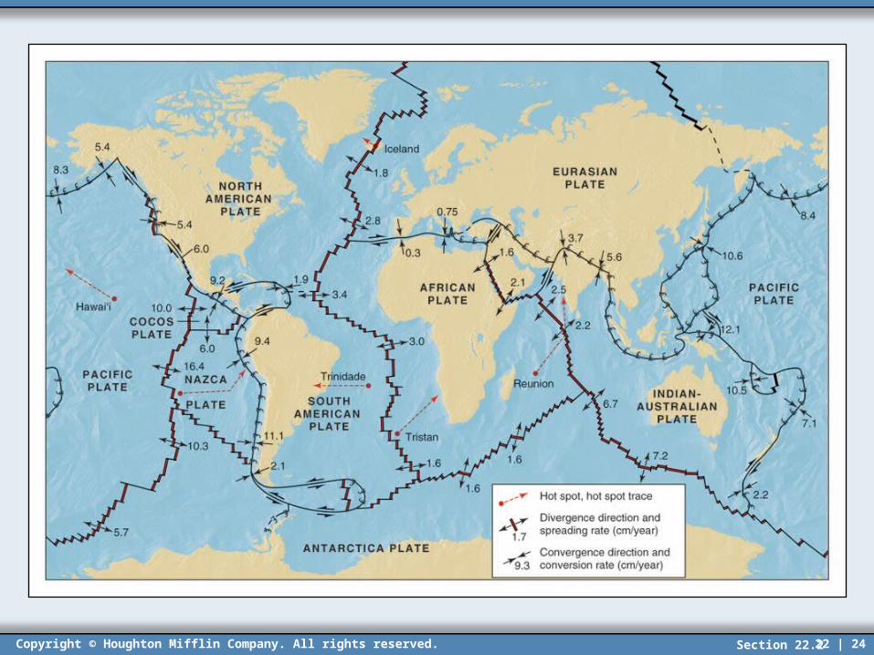
Plate Tectonics
• We now visualize ocean basins to be in a constant cycle with new crust being created at the mid-ocean ridges and old crust descending along the ocean trenches.
• We also know that the lithosphere is composed of a series of solid segments called plates.
• These plates are constantly moving and interacting with other plates.
• The theory of plate tectonics encompasses all these processes.
• The lithosphere is divided into approximately 20 plates.
Section 22.2
Copyright © Houghton Mifflin Company. All rights reserved. 22 | 24Section 22.2

Copyright © Houghton Mifflin Company. All rights reserved. 22 | 25
Plate Boundaries
• The most active areas of the Earth’s crust are along the plate boundaries. (Chapter 21)
• There are three types of plate boundaries:– Divergent – located along mid-ocean ridges where
the two plates are moving apart– Convergent – zones along which two plates are
driven together, one plate is consumed– Transform – boundaries along which two plates
slide horizontally past one another
Section 22.2

Copyright © Houghton Mifflin Company. All rights reserved. 22 | 26
The Asthenosphere
• Underlying the Earth’s solid lithosphere is a higher temperature layer - the asthenosphere.
• This layer, although basically solid, is so close to its melting temperature that it is relatively plastic and easily deforms.– The asthenosphere is much more easily deformed
than the lithosphere.
• The lithosphere may be viewed as actually “floating” on top of the asthenosphere.
Section 22.2
Copyright © Houghton Mifflin Company. All rights reserved. 22 | 27
Asthenosphere and Isostasy
• Isostasy – the concept that the solid lithosphere floats in gravitational equilibrium (buoyancy) on the plastic asthenosphere
• Continental plates float higher because they are less dense than oceanic plates.
• At any given time, all of the plates are in isostatic equilibrium.
• Mountain ranges simply represent thicker masses of continental material and therefore float higher.
Section 22.2

Copyright © Houghton Mifflin Company. All rights reserved. 22 | 28
Plate Movement
• The movement of the lithospheric is due to forces within the asthenosphere.
• Most geologists think that movement within the asthenosphere is caused by convection cells.
• Unequal temperature distribution within the asthenosphere and upper mantle results in the hot, less dense material rising, and the cooler, more dense material sinking.
Section 22.2

Copyright © Houghton Mifflin Company. All rights reserved. 22 | 29
Convection Cells in the Asthenosphere
• Drag from the more active asthenosphere drives the outermost solid lithosphere.
Section 22.2
Copyright © Houghton Mifflin Company. All rights reserved. 22 | 30
Divergent Boundary
• The mid-ocean ridge system represents a zone where two plates are moving apart – a divergent boundary.
• The initially molten magma is shouldered to each side of the rift and causes the lithospheric plates to slowly separate.
• Drag from the underlying asthenosphere keeps the plates in motion.
Section 22.2

Copyright © Houghton Mifflin Company. All rights reserved. 22 | 31
Spreading at the Mid-Ocean Ridge
• As the two plates move apart, new magma wells up and cools along the rift zone creating new crust.
Section 22.2

Copyright © Houghton Mifflin Company. All rights reserved. 22 | 32
Divergent Boundary
• As a portion of the plate moves away from the hot, spreading center it cools, contracts, and becomes more dense.
• Due to the increase in density going away from the spreading center (rift), the plate gradually subsides (isostatic equilibrium) and the oceans grow progressively deeper.
Section 22.2

Copyright © Houghton Mifflin Company. All rights reserved. 22 | 33
Convergent Boundary
• The result of two plates converging depends on the type of plates that are interacting.
• Three combinations are possible:– Oceanic-oceanic convergent boundary– Oceanic-continental convergent boundary– Continental-continental convergent boundary
• In two of these converging boundary-types one of the plates descends beneath the other plate, a process called subduction.– A subduction zone is where this happens.
Section 22.2

Copyright © Houghton Mifflin Company. All rights reserved. 22 | 34
Oceanic-Oceanic Convergence
• Both oceanic plates have essentially the same density, about 3.0 g/cm3.
• When two oceanic plates collide one is eventually subducted beneath the other.– Long narrow deep see trenches mark the zones
where the plate is subducted.
• The plate subducted begins to melt as it comes in contact with the asthenosphere.
• Molten material begins to rise, forming a volcanic island arc on the overriding plate.
Section 22.2

Copyright © Houghton Mifflin Company. All rights reserved. 22 | 35
Oceanic-Oceanic Convergence
• The deep sea trench and the volcanic island arc are parallel and close to each other.
Section 22.2

Copyright © Houghton Mifflin Company. All rights reserved. 22 | 36
Oceanic-Continental Convergence
• Since continental crust is less dense (2.7 g/cm3), it is the oceanic crust that is always subducted.
• A trench will develop along the zone where the oceanic crust is subducted.
• As the oceanic crust descends toward the asthenosphere it begins to melt.
• Magma rises up through the overriding continental plate forming volcanic mountain ranges at the surface.– The Andes and Cascades are volcanic mountains.
Section 22.2

Copyright © Houghton Mifflin Company. All rights reserved. 22 | 37
Oceanic-Continental Convergence
• The ocean trench and the volcanic mountains are parallel and close to each other.
Section 22.2

Copyright © Houghton Mifflin Company. All rights reserved. 22 | 38
The Andes Mountains were formed by oceanic-continental convergence.
Copyright © Bobby H. Bammel. All rights reserved
Section 22.2

Copyright © Houghton Mifflin Company. All rights reserved. 22 | 39
Cascade Mountains were formed by oceanic-continental convergence.
Copyright © Bobby H. Bammel. All rights reserved
Section 22.2

Copyright © Houghton Mifflin Company. All rights reserved. 22 | 40
Continental-Continental Convergence
• Continental plates have a relatively low density. (2.7 g/cm3)– Subduction of continental crust is minimal
due to its low density.
• During convergence the plate edges are intensely deformed to construct fold-mountain ranges.
• Continents can increase in size during this process by suturing themselves together along fold-mountain systems.
Section 22.2

Copyright © Houghton Mifflin Company. All rights reserved. 22 | 41
Continental-Continental ConvergenceThe Himalayas, Alps, and Appalachians are
examples.
Section 22.2

Copyright © Houghton Mifflin Company. All rights reserved. 22 | 42
Transform Boundary
• Linear zones where adjacent plates slide past each other in opposite directions.– This is a zone of shearing, or transform motion.
• Crust is not destroyed or created along a transform boundary since neither subduction nor magma upwelling occur.
• Periodic movements along these faults result in sudden energy release and repeated earthquakes.– These zones are said to be seismically active.
Section 22.2
Copyright © Houghton Mifflin Company. All rights reserved. 22 | 43
Earthquakes
• Earthquake – sudden release of energy due to a sudden movement in the Earth’s crust or mantle, resulting from stresses
• Seismology – the study of earthquakes
• Earthquakes cause the Earth’s surface to vibrate and sometimes result in violent movements, depending on the amount of energy released
Section 22.3

Copyright © Houghton Mifflin Company. All rights reserved. 22 | 44
Causes of Earthquakes
• Most earthquakes are caused by movements of the lithospheric plates.– They can also result from explosive volcanic
eruptions or by human-caused explosions.
• Movements of lithospheric plates generally cause faults in the crustal material.
• Fault – a fracture in rock along which there has been visible movement of the two sides relative to each other
Section 22.3

Copyright © Houghton Mifflin Company. All rights reserved. 22 | 45
Causes of Earthquakes
• Earthquakes are most likely to occur along plate boundaries.
• Stresses are exerted on the rock formations in adjacent plates, as movement occurs.
• Since rock possess elastic properties, energy is stored until the stresses can overcome the friction between the two plates.
• At the moment of energy release, the rocks along the fault suddenly move, the energy is released, and an earthquake occurs.
Section 22.3

Copyright © Houghton Mifflin Company. All rights reserved. 22 | 46
Recorded Earthquake Locations
• Earthquake occurrence closely follows the volcanic ring of fire.
Section 22.3

Copyright © Houghton Mifflin Company. All rights reserved. 22 | 47
Causes of Earthquakes
• Generally aftershocks will occur after a major earthquake.– These are caused by the rocks continuing
to adjust to their new positions.
• Transform plate boundaries are the locations of many of the world’s longest continuous faults (transform faults.)
• The San Andrea Fault in California is a transform fault that lies between the Pacific and North American plates.
Section 22.3

Copyright © Houghton Mifflin Company. All rights reserved. 22 | 48
San Andreas Fault of California
• The San Andreas Fault is the master fault of an intricate fault zone that runs along the coastal area of south and central California.– Many earthquakes have occurred along this fault.
• In 1906 a major earthquake occurred in the San Francisco area, resulting in hundreds of lives lost and millions of dollars of damage.
• In 1989 a major earthquake in the area caused severe bridge, building, and highways damage.
• Little can be done to control this fault line.
Section 22.3

Copyright © Houghton Mifflin Company. All rights reserved. 22 | 49
San Andreas Fault
• In about 10 million years Los Angeles will move far enough north to be adjacent with San Francisco.
Section 22.3

Copyright © Houghton Mifflin Company. All rights reserved. 22 | 50
Anatomy of an Earthquake
• The point of the initial movement, or energy release, along the fault is called the focus.
• The focus is generally located underground.– From a few miles to perhaps several hundred
miles in depth
• The point on the Earth’s surface directly above the focus is designated the epicenter.– This is the surface position that receives the
greatest impact from the earthquake.
Section 22.3

Copyright © Houghton Mifflin Company. All rights reserved. 22 | 51
Anatomy of an Earthquake
Section 22.3
Copyright © Houghton Mifflin Company. All rights reserved. 22 | 52
Earthquake – Energy Release
• When an earthquake occurs the energy released from the focus propagates outward in all directions as seismic waves.
• A seismograph monitors and measures the seismic waves.
• The greater the energy released in the quake, the greater the amplitude (height) of the traces (lines) on the recorded seismogram.
Section 22.3

Copyright © Houghton Mifflin Company. All rights reserved. 22 | 53
Seismograph• During a quake, the spool vibrates and the light beam
is relatively still.
Section 22.3

Copyright © Houghton Mifflin Company. All rights reserved. 22 | 54
Earthquake Severity
• The severity and strength of earthquakes are measured on two common scales:– The Richter Scale and the modified Mercalli Scale.
• The Richter scale measures the amount of absolute energy released during a quake by calculating the seismic wave energy at a standard distance.
• The modified Mercalli scale describes the results of the earthquake in terms of felt and observed effects.
Section 22.3

Copyright © Houghton Mifflin Company. All rights reserved. 22 | 55
Modified Mercalli Scale
Section 22.3

Copyright © Houghton Mifflin Company. All rights reserved. 22 | 56
Richter Scale
• This scale was developed in 1935 by Charles Richter of Cal Tech.– This is the most common earthquake
measurement.
• This scale correlates the largest seismogram peak during a given quake to the amount of energy released by the quake.
• The Richter scale gives the earthquake’s magnitude, expressed as numbers, usually between 3 and 9.
Section 22.3

Copyright © Houghton Mifflin Company. All rights reserved. 22 | 57
Richter Scale
• The Richter scale is logarithmic. • Each whole number increment represents a
10-fold increase in amplitude tracings.• Each whole number increment represents a
31-fold increase in energy release.• Therefore, an earthquake of magnitude 5
releases 31 times the energy of a magnitude 4.• An earthquake of magnitude 6 releases more
than 900 times the energy of a magnitude 4.
Section 22.3

Copyright © Houghton Mifflin Company. All rights reserved. 22 | 58
Richter Scale
• One significant drawback of the Richter scale is that the magnitude of the earthquake gives no indication of the damage it may cause.
• Earthquake damage depends on many factors including focus location, geologic rock types, population density, and construction types.– Relatively moderate quakes in areas with high
populations and/or poor construction techniques can cause considerable property damage and loss of life.
– More severe quakes in sparsely populated areas may cause very little damage.
Section 22.3

Copyright © Houghton Mifflin Company. All rights reserved. 22 | 59
Related Earthquake Damage
• Damage from earthquakes may be directly related to the vibrational tremors or it may result from a number of secondary effects.
• Landslides are commonly triggered by quakes– Much of the damage in the 1964 Alaskan quake
was due to a series of small landslides.
• Fires that are initiated by the initial tremors are difficult to fight due to broken water lines.
• The U.S. government (FEMA) has literature available on earthquake preparedness.
Section 22.3

Copyright © Houghton Mifflin Company. All rights reserved. 22 | 60
Submarine Earthquakes
• When a submarine earthquake occurs, some of the energy may be release into the water to form huge waves called tsunamis.
Section 22.3

Copyright © Houghton Mifflin Company. All rights reserved. 22 | 61
Earthquake Waves Help Reveal the Earth’s Interior
• Despite their destructive character, seismic waves are used by scientists to gain a better understanding of the Earth’s interior.– As these wave propagate through the Earth’s
interior their speed and direction are a function of the types of material that they penetrate.
• Scientists use seismic waves, the composition of meteorites, and high pressure/temperature laboratory experiments to decipher the composition of the Earth’s interior.
Section 22.3

Copyright © Houghton Mifflin Company. All rights reserved. 22 | 62
Seismic Waves
• Earthquakes produce seismic waves of two basic types: surface waves and body waves.
• Surface waves, as their name implies, travel within the upper few kilometers of the Earth’s surface.– Surface waves are responsible for most surface
earthquake damage.
• Body waves are transmitted in all directions through the interior of the Earth.
Section 22.3

Copyright © Houghton Mifflin Company. All rights reserved. 22 | 63
Body Waves
• Two types of body waves can be distinguished by their type of motion and speed:– P (primary) waves are compressional in
nature.• Particles move back and forth (longitudinal
compressional) in the same direction as the wave is traveling.
– S (secondary) waves are transverse in nature.
• Particles move at right angles to the direction of wave movement.
Section 22.3
Copyright © Houghton Mifflin Company. All rights reserved. 22 | 64
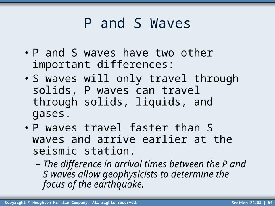
P and S Waves
• P and S waves have two other important differences:
• S waves will only travel through solids, P waves can travel through solids, liquids, and gases.
• P waves travel faster than S waves and arrive earlier at the seismic station.– The difference in arrival times between the
P and S waves allow geophysicists to determine the focus of the earthquake.
Section 22.3

Copyright © Houghton Mifflin Company. All rights reserved. 22 | 65
Body Waves - Refraction
• The velocity of body waves is dependent upon the density of the interior of the Earth.
• The Earth’s interior generally increases in density with depth, therefore body waves will curve and refract.
• Geophysicists use the travel velocity, the refraction pattern, and the travel path to interpret our modern view of the Earth’s structure.
Section 22.3
Copyright © Houghton Mifflin Company. All rights reserved. 22 | 66
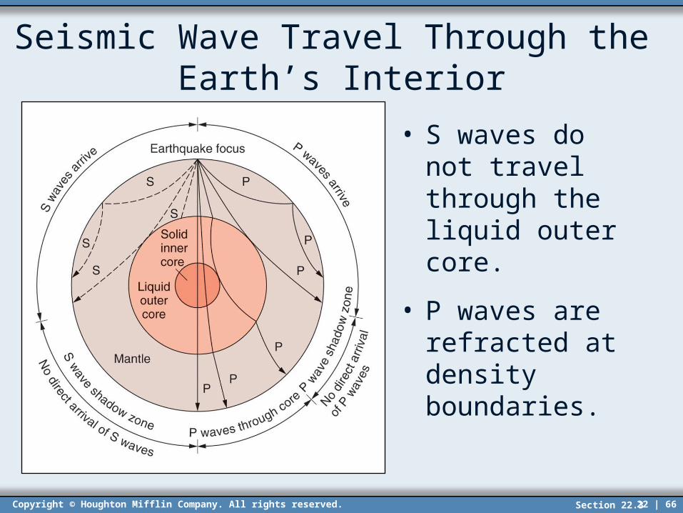
Seismic Wave Travel Through the Earth’s Interior
• S waves do not travel through the liquid outer core.
• P waves are refracted at density boundaries.
Section 22.3

Copyright © Houghton Mifflin Company. All rights reserved. 22 | 67
Structure of the Earth’s Interior
• Scientists think that the Earth is composed of four concentric layers or zones:– Inner core– Outer core– Mantle– Crust
• Different compositions and/or physical properties characterize each of these layers.
Section 22.3

Copyright © Houghton Mifflin Company. All rights reserved. 22 | 68
Interior of the Earth – Four Layers
• Evidence suggests that the inner core is solid and is composed of iron (85%) and nickel.– Radius of approximately 1230 km
• The outer core is interpreted to have the same composition as the inner core, but is liquid.– Thickness of approximately 2240 km
• The mantle’s composition is distinctly different from the outer core.
• The thin solid outer layer where we live is called the crust.
Section 22.3

Copyright © Houghton Mifflin Company. All rights reserved. 22 | 69
Interior Structure of the Earth
Section 22.3

Copyright © Houghton Mifflin Company. All rights reserved. 22 | 70
The Earth’s Crust
• The Earth’s crust ranges in thickness from 5 to 11 kilometers for oceanic crust and 19 to 40 kilometers for continental crust.– Oceanic crust is mainly composed of basalt.– Continental crust is granitic in composition.
• A sharp compositional boundary exists between the base of the crust and the upper mantle.
• This boundary is called the Mohorovicic discontinuity, simply Moho.
Section 22.3

Copyright © Houghton Mifflin Company. All rights reserved. 22 | 71
Crust and Upper Mantle – Physical Properties
• The crust and upper mantle can be divided differently if we take into account its physical properties and behavior.
• Lithosphere - outermost rigid, brittle layer– Composed of the entire crust and uppermost
mantle– Most faults and earthquakes occur in the
lithosphere.
• The asthenosphere lies beneath the crust, extending down to approximately 70 km.– Due to its high temperature this layer is plastic,
mobile, and is essential for tectonic plate motion.
Section 22.3
Copyright © Houghton Mifflin Company. All rights reserved. 22 | 72
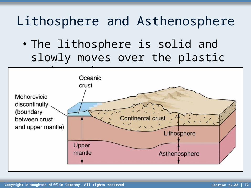
Lithosphere and Asthenosphere
• The lithosphere is solid and slowly moves over the plastic asthenosphere.
Section 22.3

Copyright © Houghton Mifflin Company. All rights reserved. 22 | 73
Crustal Deformation
• Along plate boundaries tremendous forces may be exerted that result in the buckling, fracturing, or shifting of rock units.
• These forces can rupture the plate edges into huge displace blocks and may eventually result in the formation of mountain ranges.
• Two basic types of structural deformation are common:– Folding and Faulting.
Section 22.4
Copyright © Houghton Mifflin Company. All rights reserved. 22 | 74
Crustal Deformation - Folding
• Folding – buckling of the rock layers into anticlines (arches) and synclines (toughs)
• Folding occurs when slow compressive forces apply extreme pressures on the rock layers.
• The forces that cause folding may be exerted either horizontally or vertically.
• In general, folding occurs mainly during the early stages of mountain building.
Section 22.4

Copyright © Houghton Mifflin Company. All rights reserved. 22 | 75
Crustal Folding
• In an extensively folded area, it is a particular rock layer’s resistance to erosion that determines what type of topographic feature is formed.
• Note that anticlines do not always form high ridges.
Section 22.4
Copyright © Houghton Mifflin Company. All rights reserved. 22 | 76
Crustal Deformation - Faulting
• Fault – a fracture in rock along which there has been visible movement of the two sides relative to each other
• Stresses that form faults may be compressional.– If the compression is vertical uplifts are produced.
If the compression is horizontal the crust will be shortened.
• Tensional (pull-apart) stresses can also form faults.– Tension causes the crust to lengthen.
Section 22.4

Copyright © Houghton Mifflin Company. All rights reserved. 22 | 77
Fault Terminology
• Fault plane – an approximately planar surface along which the actual movement takes place
• Hanging wall – this is the fault block that is on the uppermost side of an inclined fault plane
• Footwall – this is the fault block that is on the lowermost side of an inclined fault plane
• The fault block that has moved up relative to the other side is termed the upthrown side.
Section 22.4

Copyright © Houghton Mifflin Company. All rights reserved. 22 | 78
Fault Types
• There are three basic types of faults:– Normal, Reverse, and Transform.– Normal fault – the hanging wall (uppermost side)
moves down with respect to the footwall• Tensional forces (pull-apart) cause normal faults.
– Reverse fault – the footwall (lowermost side) moves down with respect to the hanging wall
• Compressive forces cause reverse faults.
– Strike-slip (transform) fault – stresses are parallel to the fault plane (horizontal motion)
Section 22.4

Copyright © Houghton Mifflin Company. All rights reserved. 22 | 79
Fault Terminology Illustrated
Section 22.4

Copyright © Houghton Mifflin Company. All rights reserved. 22 | 80
Mountain Building
• The mountain building process occurs most often along and because of converging plate boundaries.
• Mountains can be classified into three broad categories, based on their characteristic features:– Volcanic– Fault-block– Fold
Section 22.4

Copyright © Houghton Mifflin Company. All rights reserved. 22 | 81
Volcanic Mountains
• These mountains are primarily formed through a series of volcanic eruptions.
• Most volcanic mountains are located along convergent boundaries, since that is where most volcanoes occur.
• Along an oceanic-oceanic convergent boundary, chains of volcanic islands will form on the plate overlying the subduction zone.
• The Aleutian Islands, Japan, and the Lesser Antilles are all examples of volcanic mountains.
Section 22.4

Copyright © Houghton Mifflin Company. All rights reserved. 22 | 82
Volcanic Mountains
• Volcanic mountains also form along a continental-oceanic convergent boundary.
• The continental plate always overlies the subduction zone and this is where volcanic mountains will form.
• The Andes Mountains of South America were formed as the oceanic Nazca plate is subducted beneath the continental South American plate.
• The Cascade Mountains are also volcanic mountains.
Section 22.4

Copyright © Houghton Mifflin Company. All rights reserved. 22 | 83
Fault-Block Mountains
• Normal faulting can produce tilting and uplift of large crustal blocks.
• This will result in dramatic fault-block mountains rising abruptly above the surrounding lowlands.
• The Grand Tetons of Wyoming, the Sierra Nevada Mountains of California, and the Wasatch range of Utah are all examples of fault-block mountains in the U.S.
Section 22.4

Copyright © Houghton Mifflin Company. All rights reserved. 22 | 84
Grand Teton Mountains, Wyoming
Copyright © Bobby H. Bammel. All rights reserved.
Section 22.4

Copyright © Houghton Mifflin Company. All rights reserved. 22 | 85
Fold Mountains
• Fold mountains are characterized by prolific folding of the rock strata.
• The Alps, Himalayas, and Appalachians are all examples of fold mountains.
• These mountains are also characterized by thick packages of marine sedimentary strata.– This sedimentary strata was originally deposited
below sea level and then uplifted and incorporated into the fold mountains.
• Marine fossils are regularly found high in a fold mountain range.
Section 22.4
Copyright © Houghton Mifflin Company. All rights reserved. 22 | 86
Formation of the Himalayas – Fold Mtns.
• During the breakup of Pangea (200 m.y.a.) the subcontinent of India broke away from Africa.
• As the Indian plate moved north toward Asia, oceanic lithosphere was continually subducted beneath Eurasia.
• During the time before continental collision, sediments were deposited in the marine waters between India and Eurasia.
Section 22.4
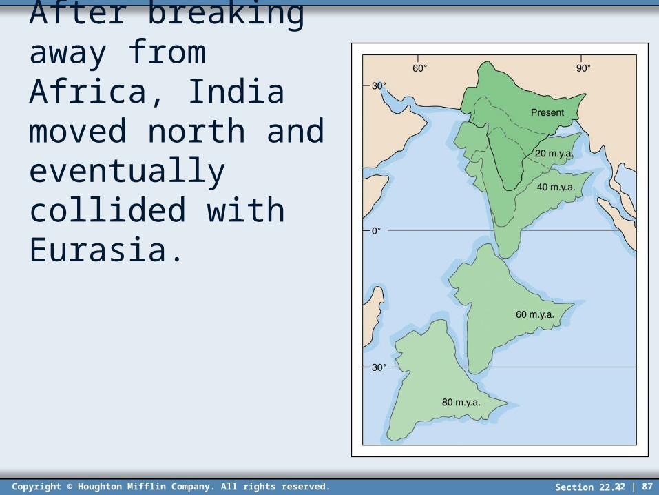
Copyright © Houghton Mifflin Company. All rights reserved. 22 | 87
After breaking away from Africa, India moved north and eventually collided with Eurasia.
Section 22.4

Copyright © Houghton Mifflin Company. All rights reserved. 22 | 88
Formation of the Himalayas – Fold Mtns.
• The sedimentary strata that was deposited between Eurasia and India was eventually uplifted and folded into the mountains.
• When the continental crust portions finally collided, subduction was significantly slowed.
• The edge of the Eurasian plate was uplifted as the continental Indian plate wedged under it.
• The Indian plate continues to move north today, resulting in continued uplift of the Himalayas.
Section 22.4
Copyright © Houghton Mifflin Company. All rights reserved. 22 | 89
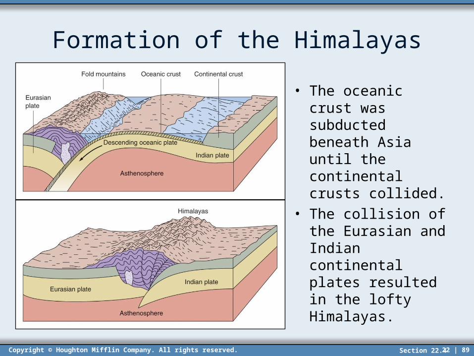
Formation of the Himalayas
• The oceanic crust was subducted beneath Asia until the continental crusts collided.
• The collision of the Eurasian and Indian continental plates resulted in the lofty Himalayas.
Section 22.4