chapter 3: existing conditions€¦ · (tsm) and multimodal approach that optimizes capacity,...
TRANSCRIPT

3
Chapter 3: Existing ConditionsExisting Transportation Elements ................................................................................................... 24
Roadway ......................................................................................................................................... 24Non-Motorized Travel ................................................................................................................. 27Transit ............................................................................................................................................. 28Passenger Rail and Bus ................................................................................................................. 29Coordinate Human Services Mobility Plan .............................................................................. 29Aviation .......................................................................................................................................... 30Freight ............................................................................................................................................ 31Distribution Centers ..................................................................................................................... 31
Population Demographics ............................................................................................................... 33Expected Population Growth ..................................................................................................... 33Alternative Transportation Needs ............................................................................................. 34

24
Central Virginia Long Range Transportation Plan 2040 UpdateChapter 3
Existing Transportation ElementsRoadway
For roadways, the focus of the Transportation Plan is the MPO region’s thoroughfare network. This thoroughfare network consists of primary routes and major secondary routes, as well as other principle streets in the study area. U.S. primary routes through the study area include Route 29 and Business Route 29; Route 221; Route 460 and Business Route 460; and Route 501 and Business Route 501. Virginia Primary Route 130 and Route 60 also pass through the study area. The thoroughfare system also includes numerous Virginia secondary routes as well as principle arterial roads within the City of Lynchburg.
Given the funding constraints, the focus of future road improvement planning will be shifted away from the construction of new roads and more towards a transportation system management (TSM) and multimodal approach that optimizes capacity, safety, and multimodal opportunities within the existing system.
CongestionThe primary technical tool used to support transportation policy and project decisions in
the Central Virginia MPO is the Travel Demand Model. The current model is a daily, three-step model (trip generation, trip distribution, trip assignment) that meets state-of-the-practice modeling standards which was developed by Citilabs Cube software. The model used for this plan update included all of the existing road network and committed projects that are currently in the Six-Year Improvement Plan, such as the Odd Fellows Interchange and the Greenview Dr. improvements. Note that mode choice has not been included in this particular model. The model is used to forecast transportation demand for the 2040 analysis years; it identifies all existing and proposed regionally significant transportation facilities; and the model reflects the latest available estimate and assumptions for land use, population, travel, employment, congestion, and economic activity.
Congestion is calculated as traffic volume divided by road capacity. Traffic volume estimates were developed by adjusting current traffic volume data by a 25 year growth rate that was set depending on the projected land development changes in the areas served by the road. Road capacity is defined as the number of vehicles that can safely travel on the road, and is a product of the number of travel lanes and the speed limit.
Corridors of high concern are those with a volume to capacity ratio of 1.1 or greater, which are depicted with red lines on the map in Figure 3.1. These roads are projected to have higher volume of traffic than they are functionally designed to accommodate. This condition will produce slower speeds of traffic and more possibilities of accidents. Most of these corridors are located on major thoroughfares within the City of Lynchburg, as well as the communities of Timberlake and Forest.
SafetyIn order to identify places in the Central Virginia MPO’s transportation network that may be in
need of safety improvements, the MPO reviewed information provided by VDOT that identifies the location and severity of every traffic accident that occurred in the region from 2011 to 2013.

25
Central Virginia Long Range Transportation Plan 2040 UpdateChapter 3
Figure 3.1: Projected Congestion Levels in 2040
26
Central Virginia Long Range Transportation Plan 2040 UpdateChapter 3
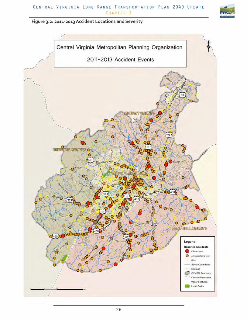
Figure 3.2: 2011-2013 Accident Locations and Severity

27
Central Virginia Long Range Transportation Plan 2040 UpdateChapter 3
The map provided in Figure 3.2 highlights the location of every accident that resulted in a fatality or severe injury during that time.
Although it unfortunately is not possible to eliminate the possibility of all accidents, this data allows the region to determine if a particular intersection or corridor experiences a pattern of severe accidents that may be the result of a deficiency in the road itself. Common improvements might include, but are not limited to, improvements such as better regulation of driveway access, installation of traffic control devices, or the addition of separated turn lanes.
The data suggests that most of the severe and fatal accidents in the MPO occur on major highways and thoroughfares. Some particular corridors that experience especially high rates of these accidents include Timberlake Rd (US 460 Business), the Lynchburg-Salem Turnpike (US 460), South Amherst Highways (US 29 Business), Wards Rd (US 29), and Forest Rd (US 221).
Non-Motorized TravelBiking and walking are efficient, low-impact modes of travel that reduce vehicle miles traveled,
do not contribute to air pollution, and can alleviate traffic congestion. The ability to safely bicycle and walk can increase levels of accessibility and mobility for everyone, but is especially important for youth, the elderly, the physically disabled, low-income earners and others who are unable to drive. Well-designed, strategically located bicycle and pedestrian facilities also provide increased and safer access to transit for more people.
In more urbanized areas, such as Lynchburg, minimizing conflicts between non-motorized modes and other users of the transportation system is critically important for safety and efficient corridor operation. Examples of conflict reduction include providing separate lanes for bicycles and well-designed pedestrian crossings. Children, in particular, have a need for safe routes to schools. Walking and biking to school can yield significant health benefits and reduce transportation costs for families and school districts.
Bicycle and pedestrian facilities also serve as important tools for economic development. They can be used to facilitate shorter trips around urban commercial and residential developments that are increasingly popular with young professionals and the businesses that employ them. Additionally, multi-use trails and greenways are valuable community amenities that promote recreation, physical activity, and improved public health. Many studies have shown increases in the values of properties surrounding these trails.
Currently, pedestrian and bicycle travel is facilitated by sidewalks that are largely located within the Lynchburg downtown, Rustburg, Town of Amherst, Madison Heights, and other commercial and neighborhood areas. Several single-use and multi-use regional corridors also exist, although they tend to be located at the edges of the region: The Appalachian Trail, the Blue Ridge Parkway, and the James River Heritage Trail system.
The Region 2000 Local Government Council has two committees devoted to the planning and development of non-motorized transportation facilities: The Region 2000 Greenway Alliance and the Region 2000 Bicycle Advisory Committee. Please see the Region 2000 Bicycle Plan and the Region 2000 Greenways, Blueways, and Trails Plan for more information about these

28
Central Virginia Long Range Transportation Plan 2040 UpdateChapter 3
efforts.
TransitPublic transit serves an important role in efforts to meet the transportation needs of the
residents of the Central Virginia MPO. Many individuals can be considered transit dependent because they are unable or cannot afford to drive. It also provides a vital mobility option for the increasing number of people who choose to reduce the amount that they drive. Currently, public transit in the CVMPO takes the form of bus and van services.
As the Central Virginia region continues to add jobs, attract economic development, and welcomes new residents, new opportunities and challenges will emerge that may require planning, innovation, and, eventually, expanded investments in transit services and infrastructure. Without these investments, the region may fail to capture emerging trends in economic development and quality of life preferences, as well as subject itself to unnecessarily high levels of auto congestion.
Currently, bus service in the Central Virginia MPO is provided by Greater Lynchburg Transit Company (GLTC). GLTC operates 14 bus routes within the City of Lynchburg and a portion of Madison Heights. Weekday services are available Monday through Friday, from 6:00 a.m. to 9:00 p.m. On Saturdays, 10 routes are active between 7:00 a.m. and 7:30 p.m.
The main transfer point for the GLTC fleet is the new transfer center located at 800 Kemper Street. All routes (except Routes MHA and MHB) begin and end at this location.
The 2011-2016 GLTC Transit Development Plan identified the following Strategic Objectives to help guide the setting of company-wide priorities:
• To seek adequate funding alternatives to offset Federal and State subsidy reductions of the next five (5) years;
• To develop a policy to establish and update service and fare standards consistent with new funding realities and mindful of GLTC’s mission;
• To continually evaluate personal mobility needs in the region and how GLTC might best meet those needs;
• To become the lead organization in the community promoting personal mobility solutions;
• To maintain a customer-focused organization through continual dialogue and resultant recognized quality improvement and innovation;
• To provide a workplace where employee involvement and participation are integral to the organization and its success;
• To continually seek ways to fully utilize capital assets which are consistent with GLTC’s mission and, where possible, enhance revenue
Additional bus services are provided in and around Liberty University by Liberty University Transit Services. This service operates an 11-route system for students, faculty, staff, and guests of Liberty University.
29
Central Virginia Long Range Transportation Plan 2040 UpdateChapter 3
Passenger Rail and BusThe CVMPO region is served by both long distance passenger trains and intercity buses. The
Lynchburg-Kemper Street Station serves as a multimodal hub for passenger rail, intercity and local bus service. It is currently serviced by four Amtrak trains daily. The Crescent Route stops in Lynchburg twice daily—once en route to New Orleans, and once en route to New York City. The Northeast Regional Route also makes two daily stops in Lynchburg. Passenger rail ridership has increased rapidly in recent years. The annual ridership at Kemper Street Station of 86,302 in 2014 represents a 365% increase of ridership in the last 5 years—up from the 23,641 riders in 2009.
Virginia is committed to a high-quality intercity passenger rail service which offers an alternative to automobile and air travel that can help reduce congestion, energy use, and environmental impacts of highways. The success of the Northeast Regional route between Lynchburg and Washington DC—serving a total of 189,723 riders in 2014—led the Virginia Department of Rail and Public Transit, Amtrak, and Norfolk Southern Corp. to agree to extend service to Roanoke. This service is expected to begin in 2017. In addition to the strong consumer demand for this service, intercity rail is also recognized as a means to address 21st century public policy goals including: reducing the nation’s dependence on foreign sources of energy, reducing greenhouse gas emissions that contribute to climate change, and increasing public safety.
Greyhound Lines also operates from the Kemper Street Station. It provides inter-city bus service throughout Virginia and offers connections to destinations all around the United States.
Coordinate Human Services Mobility PlanThe Coordinated Human Services Mobility Plan (CHSMP) was prepared in response to the
coordinated planning requirements of SAFETEA-LU (Safe, Accountable, Flexible, Efficient Transportation Equity Act—A Legacy for Users, P.L. 190-059), set forth in three sections of the Act: Section 5316-Job Access and Reverse Commute (JARC), Section 5317-New Freedom Program and Section 5310-Elderly Individuals and Individuals with Disabilities Program. The coordinated plan establishes the construct for a unified comprehensive strategy for transportation service delivery in the Region 2000 PDC (PDC 11) region that is focused on unmet transportation needs of seniors, persons with disabilities, and individuals of low income. This CHSM Plan details the coordinated transportation planning process for PDC 11, and includes the following four required elements:
• An assessment of available services that identifies current providers (public, private, and non-profit)
• An assessment of transportation needs for individuals with disabilities, older adults, and people with low incomes.
• Strategies, activities, and/or projects to address the identified gaps and achieve efficiencies in service delivery
• Relative priorities for implementation based on resources, time, and feasibility for implementing specific strategies/activities identified
Coupled with the need to identify unmet needs and gaps in transportation services is the

30
Central Virginia Long Range Transportation Plan 2040 UpdateChapter 3
need to identify corresponding strategies to help improve mobility in the region. Based on the assessment of demographics and the unmet transportation needs obtained from key local stakeholders, a variety of strategies were generated through the original CHSM planning process. These strategies were reassessed by stakeholders during the fall 2012 and summer 2013 CHSM meetings and updated accordingly.
1. Continue to support and maintain capital needs of coordinated human service/public transportation providers.
2. Expand availability of demand-response and specialized transportation services to provide additional trips for older adults, people with disabilities, veterans, and people with lower incomes.
3. Build coordination and connectivity among existing public transit providers, human service transportation providers, and colleges/universities.
4. Establish a ride-sharing program for long-distance medical transportation and other trip purposes.
5. Implement new public transportation services or operate existing public transit services on more frequent basis.
6. Expand outreach and information on available transportation options in the region, including establishment of a centralized point of access.
7. Maintain and expand flexible transportation options and more specialized or one-to-one services through use of volunteers.
8. Establish or expand programs that train customers, human service agency staff, medical facility personnel, and others in the use and availability of transportation services.
9. Expand access to taxi services and other private transportation operators.
10. Provide targeted shuttle services to access employment opportunities.
11. Bring new funding partners to public transit/human service transportation.
12. Provide low-cost/affordable transportation services that enable people to become more self-sufficient.
AviationAir transportation is an important element of the regional transportation system. It is critical
to the region and statewide economy. Tourists, business professionals, air cargo shippers, and many other people depend on the speed offered by air travel for their business and personal activities.
The region’s air travel is served by one air carrier and one general aviation airport. Regional passenger air service is provided at the Lynchburg Regional Airport, located in Campbell County, just south of the Lynchburg City Limits. US Airways Express operates 12 daily arriving and departing flights between Lynchburg and Charlotte International Airport in Charlotte, North Carolina.
31
Central Virginia Long Range Transportation Plan 2040 UpdateChapter 3
The Lynchburg Regional Airport is playing a key role in the region’s growth, serving as a convenient global gateway for the area’s international corporations, manufacturing plants, research and development firms, colleges, and universities. The airport is strategically located near the intersection of the region’s two major interregional highway corridors—US 29 and US 460—which makes it a key component of both the region’s and the state’s multimodal freight network.
Charter service is provided at Falwell Airport, located east of the interchange of US 460 and Route 501 in Lynchburg. This airport serves McLaren Corporation, which provides landing and fuel services at the airport.
FreightThe efficient movement of freight, goods, and packages is extremely important to both the
state and the region’s economy. These items are moved by railcars, trucks, vans, airplanes, and pipelines. They may move to, from, and between points in the region or pass through without a delivery or pick-up. Major intermodal terminals transfer large amounts of cargo between the various travel modes and trucks. Most freight facilities and terminals are concentrated near the intraregional corridors and statewide connectors. The majority of local deliveries and pick-ups to and from businesses in the area depend on the effective operation of the region’s principle arterial roads and local street system. The map in Figure 3.3 highlights the primary freight corridors in the Central Virginia MPO Region.
The Virginia Statewide Multimodal Freight Study identified twelve “Corridors of Statewide Significance” in Virginia that represent the vital multimodal corridors that connect the Commonwealth’s major activity centers to one another and to other states. These corridors carry a high volume of both freight and passenger travel, and are considered priorities for the state’s transportation improvement funding. Two of these corridors intersect in the Central Virginia MPO: the Heartland Corridor (US 460) and the Seminole Corridor (US 29).
Two rail lines, Norfolk Southern and CSX, use Lynchburg as a freight interchange and junction point. The rail lines pass through downtown Lynchburg and continue through northern and northeastern Lynchburg into Amherst and Appomattox Counties. CSX operates between Newport News, Louisville, Cincinnati, Columbus, Lynchburg, Danville, and on to Atlanta and points south.
In recent years, Norfolk Southern has engaged in two major rail corridor improvement projects that affect freight train travel in Lynchburg. The Heartland Corridor Project was a public-private partnership that was used to increase freight capacity between Virginia’s ports and the Midwest, while the Crescent Corridor Project is increasing rail capacity between the major centers in the Northeast such as New York City and Philadelphia, and major centers in the Southeast such as Memphis and New Orleans.
Distribution CentersVirginia has experienced marked growth in large-scale warehousing development often
associated with high-volume, or “big box” importers. These importers’ supply chains are highly dependent upon the uninterrupted flow of cargo—primarily containerized—through Virginia’s ports, and subsequently through its highways and rail connections.

32
Central Virginia Long Range Transportation Plan 2040 UpdateChapter 3
Figure 3.3: Truck Traffic Volume

33
Central Virginia Long Range Transportation Plan 2040 UpdateChapter 3
Population DemographicsIn addition to the conditions of infrastructure and traffic operations, transportation planning
efforts must also understand the conditions of population growth in a region, as well as the variety of transportation needs that may exist for the people who live there.
Expected Population GrowthIn 2012, the Virginia Employment Commission published population projections for the
Commonwealth’s cities, towns, and counties through the year 2040. According to this data, which is shown in Figure 3.4, the population of the Lynchburg Metropolitan Statistical Area is expected to increase by 17%, from 252,634 in 2010 to a projected 305,995 in 2040.
Figure 3.4: Lynchburg, VA Metropolitan Statistical Area Population Projections2010 2020 2030 2040
252,634 271,131 288,662 305,995Source: Virginia Labor Market Information (www.virginiaLMI.com)
This data report also provides population projections for each of the member localities in the Central Virginia MPO, provided in Figure 3.5. These estimates pertain to the entire counties, rather than only those portions that are included in the MPO area, meaning that some of the population growth is likely to occur outside of the CVMPO area. Despite this fact, these estimates offer insight into the general patterns of population growth that will affect the MPO.
According to these projections, the largest amount of growth in the region is expect to occur in Bedford County. In 2040, the total population of Bedford County (which includes areas outside of the CVMPO) is expected to exceed that of the City of Lynchburg. The City of Lynchburg and Campbell County are both expected to experience moderate growth during this period, while Amherst County is expected to experience relatively low growth.
Figure 3.5: Projected Population Growth 2010-2040 by Jurisdiction
Jursidiction 2010 Population 2040 Population Projection
Population Change
Percentage Change
Amherst County* 32,353 35,340 +2,987 8%Bedford County* 68,676 95,943 +27,267 28%
Campbell County* 54,842 62,825 +7,983 13%
City of Lynchburg 75,568 87,137 +11,569 13%*Denotes jurisdiction with areas not included in the CVMPO region
Source: Virginia Labor Market Information (www.virginiaLMI.com)
34
Central Virginia Long Range Transportation Plan 2040 UpdateChapter 3
Alternative Transportation NeedsLike many cities in America, most people living in the Lynchburg Metropolitan area rely on
private automobiles to meet their transportation needs. Some people, however, are subject to conditions that make transportation by automobile a difficult or dangerous mode of travel. These people may rely on a variety of alternative forms of transportation to meet their travel needs.
This chapter identifies some of the major groups of people that may rely on alternative modes of transportation. Each section briefly describes the reasons that members of the group may need to rely on other form of transportation, identifies areas in the metropolitan region in which a large number of their members may be found, and explains what types of transportation infrastructure or services may support their travel needs. It is the goal of the CVMPO to help provide a high quality of life for people of all abilities. It supports efforts to improve the mobility of people who have special transportation needs.
ElderlyElderly people commonly have physical or mental conditions that make the operation of an
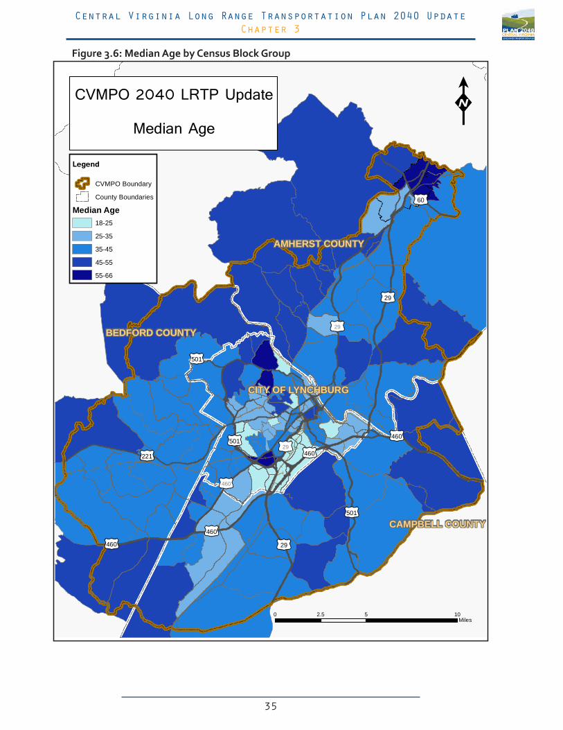
automobile a dangerous or difficult activity. In many cases, a person may lose the ability to safely operate an automobile before they lose the ability to live independently. When this occurs, they must rely on alternative modes of transportation to access important services such as groceries and medical care. The areas of the Lynchburg Metropolitan area with the highest median age, as illustrated in Figure 3.6, include neighborhoods in the northern part of the City of Lynchburg and in the Town of Amherst.
Elderly residents who are still able to walk and live nearby these services will benefit from effective pedestrian infrastructure such as sidewalks, crosswalks, and pedestrian bulbs and medians at major street crossings.
Those who are unable to walk or live too far away from these services to reach them on foot may rely on transit or paratransit services. Fixed route transit services, such as those offered by the GLTC, should attempt to make their bus stops as accessible as possible to elderly users, especially when a route provides service in an area of the city that has a high elderly population.
YouthYoung people who are below the legal driving age are unable to operate an automobile. When
children become old enough to engage in activities outside the home without the accompaniment of their parents, they may use alternative modes of travel such as walking and biking to reach their destinations. These modes of transportation are especially important for children who travel independently to and from school.
Young residents will benefit from effective pedestrian infrastructure such as sidewalks, crosswalks, and pedestrian bulbs and medians at major street crossings. Those who choose to use a bicycle will benefit from designated bicycle lanes or mixed use trails.
Disabled Some people with disabilities may lose the ability to physically operate an automobile. When this
35
Central Virginia Long Range Transportation Plan 2040 UpdateChapter 3
60
29
29
501
221
460
460
501
460
501
46029
29
460
BEDFORD COUNTY
AMHERST COUNTY
CAMPBELL COUNTY
CITY OF LYNCHBURG
0 5 102.5Miles
CVMPO 2040 LRTP Update
Median Age
Legend
CVMPO Boundary
County Boundaries
Median Age18-25
25-35
35-45
45-55
55-66
Figure 3.6: Median Age by Census Block Group

36
Central Virginia Long Range Transportation Plan 2040 UpdateChapter 3
occurs, they may occasionally or frequently rely on alternative or public modes of transportation to travel to school, work, stores, or medical care. The areas of the Lynchburg Metropolitan area with the highest rate of disabled populations are primarily found in and directly surrounding the downtown City of Lynchburg and Madison Heights. This is illustrated in Figure 3.7 below.
People with disabilities are able to access many more destinations when infrastructure is designed to accommodate their needs. Examples of these accommodations may include wide sidewalks that are clear of obstacles such as poles or trees, sidewalk ramps that create an easy transition from street to sidewalk level, and bus stops that are served by handicap accessible sidewalks and ramps. Paratransit services that can provide transportation directly from a disabled person’s home to their destination can be especially valuable.
60
29
29
501
221
460
460
501
460
501
46029
29
460
BEDFORD COUNTY
AMHERST COUNTY
CAMPBELL COUNTY
CITY OF LYNCHBURG
0 5 102.5Miles
CVMPO 2040 LRTP Update
Disability Rate
Legend
CVMPO Boundary
County Boundaries
Percent Disabled0% - 10%
10% - 20%
20% - 30%
30% - 40%
40% - 50%
Figure 3.7: Percentage of Population with a Disability by Census Block Group

37
Central Virginia Long Range Transportation Plan 2040 UpdateChapter 3
ImpoverishedIndividuals and families whose incomes are below the designated poverty line may be unable
to afford to own or operate an automobile. It is important that these individuals are able to access needs such as work, school, groceries, and medical care. The areas in the Lynchburg Metropolitan Area with the highest rates of poverty are primarily found in the City of Lynchburg near downtown and surrounding Campbell Ave. This is illustrated in Figure 3.8 on the following page. This map also shows a large concentration of poverty surrounding the Liberty University Campus and Wards Rd shopping area. This most likely reflects the student population of Liberty University who are attending the university full time and are financially supported in part by their parents or guardians. People in this group are not necessarily subject to the same hardships of poverty as those who are unemployed, working full time, or have no other means of financial support.
Those people who choose to walk or ride a bicycle will benefit from safe and well maintained infrastructure such as sidewalks, cross walks, and bicycle lanes. It is also important that they have ready access to transit services for destinations that are beyond reasonable walking or biking distance. It is especially important that people living in poverty have safe and complete routes to schools and employment centers that may enable them to achieve greater financial stability.

38
Central Virginia Long Range Transportation Plan 2040 UpdateChapter 3
60
29
29
501
221
460
460
501
460
501
46029
29
460
BEDFORD COUNTY
AMHERST COUNTY
CAMPBELL COUNTY
CITY OF LYNCHBURG
0 5 102.5Miles
CVMPO 2040 LRTP Update
Poverty Rate
Legend
CVMPO Boundary
County Boundaries
Percentage in Poverty0% - 12.5%
12.5% - 25%
25% - 37.5%
37.5% - 50%
50% - 62.5%
Figure 3.8: Poverty Rate by Census Block Group