chapter 3.1 introduction -...
TRANSCRIPT

CHAPTER
Settlement Patternsand Ways of Lifein Canada
33.1 Introduction
James is a sixth grade student in Pond Inlet, a town in Nunavut. Nunavutis in the far north of Canada. When James goes to school in January, thesun never comes up. If he looks out his classroom window in the darkwinter months, all he sees are streetlights and the lights of cars. Some ofhis classes are taught in English. Others are in Inuktitut, the language ofthe Inuit. James and most of the other sixth graders also speak Inuktitutat home. In their language, the town's name is Mittimatalik.
Compare James with Marie, a sixth grader in Quebec City. Marie isFrench Canadian. All of her classes are in French. It is always light out-side when she is in school. Marie can see many people on the streetsoutside her school. James and Marie live in the same country. But theirexperiences are very different.
Canada is a large, very diverse country. It is often called a pluralsociety. This term reflects the fact that its people have come from manycountries and cultures. While most people share a Canadian identity,many also keep the traditions of their parents and grandparents.
Canadians often divide their country into five regions. In this chapteryou will learn about these regions. You will look at how differently peoplelive in each one. You will also find out how location influences the waypeople live.
Essential Question
How does where you liveinfluence how you live?
This illustration shows thefive regions of Canada. Eachregion has a different climate.Each region's history andeconomy are different too.These differences affecthow people live in Canada.Keep this illustration inmind as you try to answerthe Essential Question.
Graphic Organizer
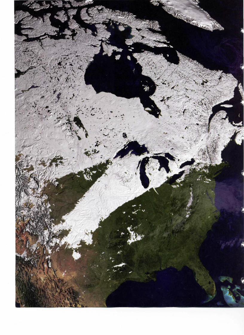
Satellite image of Canada and the United States in winter51

Canada's Population
Most Canadians Live in Cities
Eight out of 10 Canadians live in urbanareas. Only one fifth live in rural areas.Most Canadians live in the ecumene aswell. This is found in the southern partof the country, mainly the southeast.
3.2 The Geographic Setting
In area, Canada is the world's second largest country. It covers mostof the northern part of North America. The United States is its neigh-bor to the south. The two countries share a 5,000-mile-long border.This is the longest unguarded border in the world.
Canada's Three "Founding Peoples" The first people to settlein Canada probably came from Asia tens of thousands of years ago.They crossed over a land bridge between Siberia and Alaska. In time,they became the Inuit and other Native American groups. These nativepeoples still live in Canada. Today they are known as Canada's first"founding peoples."
Canada's second and third founding peoples came from Europe.Colonists from France settled Quebec in the 1600s. Later, Englishcolonists settled on the Atlantic coast. In the 1700s, France andEngland fought a war for control of North America. When thewar ended in 1763, France agreed to give up Canada to England.
During the 1800s, large numbers of English settlers came toCanada. But the French-speaking people held on to their languageand way of life. Meanwhile, Canada also attracted settlers fromIreland, Scotland, Sweden, Norway, and Germany. By the early1900s, Italians, Ukrainians, and Jews were arriving from southernand eastern Europe. Some settled in the big eastern cities. Othersbegan farms on the flat land in Canada's center. Chinese, Japanese,and Filipino people came from Asia as well. Many of them settledalong Canada's Pacific coast.
All of these groups have helped shape Canada's plural society.Its founding peoples have kept their languages and traditions. Newersettlers have also held on to traditional ways from other cultures.Yet all are Canadians.
A Thinly Settled Country Canada is large in area but small inpopulation. In 2001, just over 30 million people lived there. That isfewer people than lived in the state of California.
Nearly 8 out of every 10 Canadians live in an urban area. Theseare areas in or around cities. The rest of the population make theirhomes in rural areas. These are parts of the country that are notnear cities.
Most of Canada's people live within 100 miles of the UnitedStates. This strip of land lies within Canada's ecumene. An ecumeneis any region that is well suited for people to live there permanently.
Many Americans think that Canadians' lives are just like theirs.This is not the case. It is true that many Canadians live close to theUnited States. It is also true that Canada and the United States areeach other's most important trading partners. And it is true that theyare good allies. But there are many differences between the twocountries. Some of these are political. Others are economic, andsome are cultural.
52 Chapter 3

Geoterms
ecumene a geographic region that is well suited forpermanent settlement by people. Areas not includedin the ecumene are generally too dry, too cold, or toorugged for permanent human settlement.
plural society a society in which different cultural groupskeep their own identity, beliefs, and traditions
rural found in or living in areas that are not close to cities
urban found in or living in a city
Canadians Cling to the Border
Canada has only about one tenthas many people as the United States.Much of the Canadian north liesoutside the ecumene. It is so coldthat few people choose to live there.Most of Canada's people live within100 miles of the U.S. border.
Population Density of Canada
:
NEWFOUNDLAND &LABRADOR x
Ecfubt-Area projection II- .. _J> I /
Settlement Patterns and Ways of Life in Canada 53

3.3 Canada's Five Regions
Canada is divided into provinces andterritories. There are 10 provinces.Each has its own government. In thisway, provinces are much like statesin the United States. Territories areareas that have too few people tobe provinces.
Geographers often divide Canadainto five large regions. They are out-lined in black on the map you seehere. As you will learn, each regionhas its own geography. Each also hasits own history and way of life.
Atlantic Region This region linesthe Atlantic coast of Canada. Itincludes the provinces of Labradorand Newfoundland, Prince EdwardIsland, Nova Scotia, and NewBrunswick. Some of these provincesare islands in the Atlantic Ocean.
Core Region This region stretchesnorth of the Great Lakes. It includesthe two large provinces of Ontarioand Quebec.
Prairie Region This region coversCanada's central plains. It includes theprovinces of Manitoba, Saskatchewan,and Alberta.
Pacific Region This region is onCanada's Pacific coast. It is made upof the province of British Columbia.
Northern Region This regionlies to the north of the provinces.It reaches far into the Arctic Ocean.It includes Canada's three territories.These are the Yukon Territory, theNorthwest Territories, and Nunavut.
The Five Regions of Canada 160W 150W 14QW
\
ARCTIC O C E A N
NORTHWESTTERRITORIES
SASKATCHEWAN
Resources
X Coalf Hydroelectric power
<Q) Natural gas
5 Petroleum (oil)
^-^ Precious metals^^ (gold, silver, copper)
Bp Uranium
- "> < ' ' ,_^-^^ ^
• /.-' i
//•'-*••'• f -̂' J *'•
ElevationFeet Meters
Over 10,000 •• Over 3,0505,001-10,0000 1,526-3,0502,001-5,000^ 611-1,5251, 001-2,000 Lj 306-610
0-1,000| 1 0-305
' . • • •
54 Chapter 3

130W 110W SOW 70W 6flW 51120W 100W SOW
>
7 NEWFOUNDLAND &LABRADOR
sow
PRINCE EDWARD ISLAND
ATLANTIC
OCEAN
0 250 500 kilometersLambert Azimuthal Equal-Area projection
Settlement Patterns and Ways of Life in Canada 55

3.4 Settlement Patterns: Who Lives Where?
Imagine that you could spread Canada's people out evenly. Abouteight people would live in every square mile. But Canada's peopledo not live like this. Outside of the large cities, an average of onlytwo people live in every square mile.
The Atlantic Region This was the first area where Europeanssettled in Canada. They came because fishing was so good in theNorth Atlantic. Until recent years, most people here made a livingby fishing. But the ocean has been overfished. The government nowlimits fishing to make sure there will be fish in the future. As a result,many people have moved away.
A Population on the Move
Parts of Canada lost people between1996 and 2001. Other parts gainedpeople. The numbers show the percentof the loss (-) or gain (+) compared tothe 1996 population. Although Nunavutshows a large population growth,its total population in 1991 was only27,000 people.
The Core Region Most Canadians live in Canada's core region.This region has three of Canada's largest cities. They are Toronto,Montreal, and the capital city of Ottawa. In the past, people came toOntario to work in its many factories. More recently they have comefor jobs in banks, computer companies, and other businesses.
The Prairie Region About 5 million people live in the three prairieprovinces. Farming was once the main activity here. Today the oiland gas business is booming in Alberta. As a result, Alberta is thefastest-growing province in Canada. Its biggest cities are Edmontonand Calgary. Both are popular urban areas.
Population Change in Canada, 1996-2001
More than 4% increase0-4% increase0-4% decreaseMore than 4% decrease
NEWFOUNDLAND andLABRADOR
-7.0%
BlOLUMBIA I +103%
.9% I
0 250 500 kilometersLambert Azimuthal Equal-Area projection
PRINCE EDWARDISLAND+0.5%
NOVASCOTIA-0.1%
Source: Swrm/f.s Canada, www.statcan.ca.
56 Chapter 3

r
The Pacific Region British Columbia is home to more than4 million people. Most live around the city of Vancouver or Victoria.People also live on the western slopes of the Rocky Mountains. Manypeople from Asia have moved to this region. This is because of itslocation on the Pacific Ocean.
The Northern Region This is the largest region in land area. But ithas the fewest people. Only about 100,000 people live in all three ter-ritories. The region is costly to live in because it is so far from otherplaces. There are so few roads that goods are often flown in by plane.
3.5 A Plural Society: Who Speaks What?
If you walked around Toronto, you would hear people speakingmany different languages. Of course, you would hear English andFrench. But many other cultural groups live there as well. Torontohas one of the most multicultural school districts in the world.More than half the students in the city speak a language otherthan English at home.
The Atlantic Region Most people in this region speak English astheir first language. Their families came from Great Britain to farmor fish many years ago. Some French speakers settled here as well.French remains their first language.
The Core Region In Ontario, most people speak English. But inQuebec, most people speak French. Other languages spoken hereinclude Chinese, Italian, and Portuguese. For many years, Canadiansargued about which language their government should use. Now bothFrench and English are its official languages. Some people in Quebecthink their province should be a separate country. In 1995, the peopleof Quebec voted on this question. They decided to stay part of Canada,but it was a close vote.
The Prairie Region European settlers first came to this region tofarm. Now, oil in Alberta attracts newcomers. English is the first lan-guage for more than four out of five people in this region. But peoplewho speak French, German, and Ukrainian have moved here too.
The Pacific Region Here, English is the first language. But manypeople from Asia also live in this region. Chinese is the second mostcommon language. People from India speak Punjabi. People from thePhilippines speak Tagalog.
The Northern Region Almost two thirds of the people in the northspeak English as their first language. Many are English-speakingCanadians who moved here to work for the government. Most of thefounding peoples, such as the Inuit, have kept their cultures. The Inuitcontinue to speak Inuktitut.
Canada's Official Languages
Canada has two official languages.Signs all over the country are in bothEnglish and French. The 2001 census
showed that about 22 percent ofCanadians speak French most oftenat home. Almost 68 percent speakEnglish most often at home. The third
most spoken language is Chinese.
Settlement Patterns and Ways of Life in Canada 57

Surf's Up in the Winter
In the winter, storms slam into Van-couver Island, often creating 15-footwaves. Winter surfing is attemptedby only the most dedicated surfers.To survive the cold, they wear rubbersuits with hoods, gloves, and booties.
Winterlude: A Festival of Winter
Winterlude celebrations take placein Ottawa in February. Here, peopleplay on an ice slide in a park. In thebackground is a snow sculptureof one of the Parliament Buildings.These buildings are the center of thenational government.
3.6 Having Fun in the Cold
Winters are long and summers are short in this northern country.Canadians have adjusted by finding ways to have fun in all seasons.In summer, for example, people use the Rideau Canal in Ottawa forboating. But in the winter the canal freezes. For a few months itbecomes the longest skating rink in the world.
The Atlantic Region This area has a fairly mild humid continentalclimate. Winters can be very wet. Halifax, for example, gets fiveinches of precipitation in January alone.
Nova Scotia is said to be the birthplace of ice hockey. The storygoes that Canadians were unhappy spending the long winter monthsindoors. They knew of a game that is like field hockey. Someonethought to put on skates, and ice hockey was born. Today ice hockeyis popular in the United States too.
The Core Region The southern part of this area has a humidcontinental climate. Toronto's average temperature in July is apleasant 63 °F.
Every February, Canadians celebrate Winterlude in Ottawa.People ice skate and ride sleighs along the Rideau Canal. There areraces and figure-skating contests. You can learn how to make icecarvings. Or you can eat at a cafe carved from ice!
The Prairie Region The southern part of this region has a scmiaridto humid continental climate. The northern part has a subarctic climate.In Churchill, the average January temperature is a frosty -16°F.
Churchill is called the "Polar Bear Capital of the World." Once ayear, more than 1,000 migrating polar bears pass through this town.People travel each year to Churchill to see this event.
The Pacific Region The coast of British Columbia has a marinewest coast climate. In Vancouver, January temperatures average 37°F.This is much warmer than most parts of Canada.
Winter surfing is a popular sport off the Pacific coast. Largewaves from winter storms challenge surfers there. Farther inland liethe Coast Mountains and the Rockies. The high altitudes here meanlong, cold winters. You will find some of Canada's best ski resorts inthis region.
The Northern Region Much of this area is treeless tundra. Themost northern part has very few plants. The southern part has a sub-arctic climate. The temperature in the town of Whitehorse in Julyaverages 57°F.
The all-terrain vehicle has replaced the dog sled in the north. Butpeople still love to compete in dog sled races. A long-distance racecan cover 1,000 miles and take up to two weeks.
58 Chapter 3

3.7 Different Traditions and Needs:What's Built Where?
Let's say you are visiting the Museum of Civilization,a short trip from Ottawa. You see houses of Canada'snative peoples. Later you look at a lumber camp. Thenyou walk past an oil derrick or a fishing village. Yousoon see how people's needs and traditions, as well astheir locations, have led them to build different kindsof structures.
The Atlantic Region Lighthouses dot the coast inthis region. This is because of the importance of fishing.Lighthouses help sailors figure out their position on theocean. They let ships know that land is near and warn ofdangerous rocks. Canada still has about 275 lighthousesin operation.
The Core Region Many buildings here combineBritish and French influences. The Parliament Buildingsin Ottawa were built in the Gothic revival style. Britishand French settlers brought this style from Europe.These large stone buildings have tall, pointed windowsand carved ornaments. Another example of this styleis the Chateau Frontenac. This is a famous hotel inQuebec City.
The Prairie Region Farms cover the southern partof this region. The typical farm sits on hundreds ofacres. Beside the barn is a silo. This is a tall structurefor storing grain. Farmers in this rural region usuallygrow spring wheat. This crop is planted in the springand harvested in late summer. It grows well in climateswith harsh winters.
The Pacific Region British influence is strong here.Victoria was the first city in British Columbia. It isknown as the most British of Canadian cities. Somebuildings there look almost like castles.
The Northern Region This region has long, coldwinters. In the past, some Inuit made winter igloosfrom snow blocks. The word igloo means "house."Igloos can also be made of other materials, such as sod,stone, or wood. Today, most Inuit have houses madefrom kits. Such a house is put together from sectionsmade in factories. Inuit live in widely scattered villagesalong the Arctic Ocean or Hudson Bay.
A Variety of Building Styles
Each region of Canada has its own styles of buildings.Sometimes these styles grow out of the needs of thepeople living there. Sometimes they reflect ideas thatsettlers brought with them from Europe about whatbuildings should look like.
Settlement Patterns and Ways of Life in Canada 59

3.8 How People Make a Living
Canada's Plentiful Resources
This map shows the natural resourcesfound in Canada. The location ofnatural resources tells much about aregion's economy. It also shapes landuse in a region.
Canada is rich in natural resources. Furs and lumber were earlyexports. Today oil and minerals are important as well. Even so, mostCanadians today work in service industries. These industries producea service for people rather than goods. Examples include restaurants,dry cleaners, and banks.
The Atlantic Region In the 1800s, this region had a strong econo-my. Good fishing in the Atlantic Ocean made it easy to make a living.But, as you read earlier, overfishing has led to limits on fishing. That,in turn, has put many people out of work.
Coal mining and farming are also economic activites here. But poorsoil limits farming to small patches of good land. Forestry is a grow-ing industry. Forestry companies produce lumber and pulp for paper.
The Core Region Most of Canada's factories are located here. Thisregion is also a strong farming center. More than a third of Canada'sfarm products are grown here. Recently, the region has become alarge producer of hydroelectric power. This is electricity generatedfrom flowing rivers. Some power plants are located on rivers innorthern Quebec. Others are found near Niagara Falls or along theSt. Lawrence River.
Economic Activity in Canada Land Use
| Hunting and gathering| | Commercial farmingI | Nomadic herding
1 Livestock raising^H Commercial fishingI ForestryI Trade and manufacturing
I I Little or no activity
Resources
X Coal4 Hydroelectric power^ IronO Natural gasH Petroleum (oil)
Precious metals(gold, silver, copper)Uranium
0 500 1,000 kilometers
Lambert Azimuthal Equal-Area projection
60 Chapter 3

•
-
-
•
The Prairie Region This region produces half of thecountry's farm products. Its southern plains are good forraising grains. Mining is also important. More than halfof Canada's minerals are mined here. They include coal,nickel, copper, zinc, and uranium.
Much oil is trapped in the oil sands of northernAlberta. This area is thought to contain more oil than theentire Middle East. It is expensive to separate oil fromthe sand. But because demand for oil is high, Alberta'soil business is booming. The same is true in Edmonton,one of the fastest-growing cities in Canada.
The Pacific Region Forestry and fishing are importantin British Columbia. But now newer industries havepassed these by. Both metals and coal are mined inthis region. The shipping industry is growing as well.Shippers on the coast carry Canadian products to all partsof the world. Many rivers have been dammed to producehydroelectric power. Much of the electricity generated inthe region is sold to the United States.
The Northern Region Some native peoples stillfollow the nomadic, or wandering, life of herders andhunters. But most are settled in small villages. Becausethere is little business in most villages, jobs are few.Canadians from the south sometimes come here to workfor short periods. They find jobs with the government,churches, or mining companies. Many people in theterritories believe that there are undiscovered preciousminerals still to be found here.
3.9 Beginning to Think Globally
In this chapter, you have learned about settlement patterns and waysof life in Canada. You have read about the different groups that makeup Canada's plural society. You have learned about urban and ruralareas in Canada.
For the most part, people have settled in Canada's ecumene.But not all Canadians live in the ecumene. Some people live inthe subarctic region of Canada. A few even live in the far northerntundra zone.
This variety of settlement is found in many places around theworld. Consider Australia, for example. Many aborigines, the nativepeople of Australia, choose to live in remote deserts. There they areable to keep their way of life. But they face other problems, such aslack of work and the challenge of keeping their culture alive. Thinkabout these relationships between location and ways of life as youexplore settlement patterns around the world in the next section.
Living Outside the Ecumene
People who live outside the ecumenehave adapted to harsh conditions.This Inuit hunter is warmly dressedeven on a summer day.
Settlement Patterns and Ways of Life in Canada 61

3.10 Global Connections
This map shows where people livearound the world. The areas in purpleare the most densely populated regions.These are population hot spots in theglobal ecumene. The gray areas arevery thinly populated. They lie outsidethe global ecumene. Notice that differ-ent parts of the ecumene have differ-ent population densities. Why do youthink this might be so?
What climate zones are likely tobe found in the global ecumene?The climates found in the ecumeneare neither too hot nor too cold.People can live there comfortably.Areas outside of the ecumene oftenhave extreme temperatures. Few cropscan be grown in such climate regions.That helps explain why they are notpart of the ecumene.
Which physical features arelikely to lie outside the globalecumene? Some of Earth's physicalfeatures are not well suited for humansettlement. Very few people live inmajor deserts. These areas are too dryto support life. Most mountainousregions are thinly settled. They are toorugged for most people. Many largeswamps also lie outside the ecumene.
What might life be like forpeople who live outside theecumene? Most of the world'speople live within the global ecumene.However, some people live in less pop-ulated areas. They survive by findingways to stay warm, keep cool, findwater, or keep dry—even in the harsh-est conditions. In later chapters, youwill look at different ways peopleadapt to living in extreme environ-ments outside the ecumene.
Ecumene Around the World
Tropic of Cancer
Population Density
Part of the ecumeneOver 250 people per sq. mile125-250 people per sq. mile25-125 people per sq. mile2-25 people per sq. mile
Not part of the ecumeneHI Under 2 people per sq. mile
62 Chapter 3

PACIFIC
opic of Cancer —
20°N
0° 20°E 40°E 60°E 80°E 100°E 120°E 140°E' 1
c
»"
Settlement Patterns and Ways of Life in Canada 63