chapter 4 · chapter 4 chapter 4 - agency ... all garbage and trash collected is to be hauled to an...
TRANSCRIPT
Chapter 4 Agency Responsibility
Chapter 4
Chapter 4 - Agency Responsibility This section is concerned with the lands under the jurisdiction of Reclamation and being administered for recreation and fish and wildlife purposes by the Commission. Agreements Lease (Contract No. 14-06-700-3816-A) between the United States and the State of Nebraska dated May 1, 1995, formalizes the administration and management of lands in the Box Butte Reservoir area. This document is included in Appendix A1. Responsibilities This section references information in the lease agreement between the United States and the Commission. Maintenance Facilities The Commission shall employ good management practices and operate and maintain the leased premises, including Reclamation’s improvements of Reclamation facilities and those which shall be erected by the Commission, in a good and reasonable state of repair, reasonable wear and tear excepted, at its own cost and expense as may be supplemented by Reclamation funds, when available. Fencing Reclamation is responsible for initial boundary fence construction and replacement around reservoir lands. The Commission is responsible for maintaining boundary fences in a good and reasonable state of repair, reasonable wear and tear excepted, on lands administered by the Commission. The Commission is also responsible for the construction and maintainence of any interior fences needed for wildlife and/or recreation purposes. Reclamation may provide fencing materials, when funding allows, as well as planning assistance to improve conditions. Signing The Commission will install and maintain boundary signs on Reclamation lands managed by the Commission. Wildlife Management Area (WMA) signs are placed at most property corners to identify public lands. Uplands around the upper two thirds of the reservoir area were purchased to a specific elevation (4012’) rather than a metes and bounds description. This area has been surveyed
32
Agency Responsibility
and property boundary signs have been placed along the fenceline. Reclamation may provide signing materials when funding allows. Reclamation and the Commission will work cooperatively to ensure all public lands are signed. Roads Maintenance, reconstruction, or improvement of certain access roads within the reservoir area for recreation and/or wildlife purposes is the responsibility of the Commission. Reclamation may provide financial assistance for maintenance as funding allows. Routine maintenance is restricted to primary access roads and designated use areas. Maintenance or improvements to undesignated roads and off-road vehicle (ORV) trails is not permitted without Reclamation’s approval. Shoreline Erosion The Commission is responsible for the control of shoreline erosion near recreation areas which may threaten public safety. The Commission is responsible for erecting signs notifying the public of the erosion hazards if they exist. Reclamation may provide shoreline erosion control measures; such as rip-rap and planning assistance, as funding allows, to improve this condition. The Commission is responsible for obtaining the required permits from the U.S. Army Corps of Engineers. Public-Use Regulations The Commission administers both the land and water surface, and the Law Enforcement Division assumes the responsibility for the enforcement of all game, fish, and boating laws and regulations. The Parks Division is responsible for enforcing park regulations. The Commission is also responsible for identifying trespass and Federal regulations covering ORV, and other related fish and wildlife use on the leased premises. The Commission takes all reasonable precautions and assists in the prevention, control, and suppression of fires on the leased premises. The Commission also establishes and enforces laws, rules, and regulations for fish and wildlife use to protect the health and safety of persons using the areas and to preserve law and order. The Commission does not engage in, permit, or allow any activity within the leased premises which will interfere with the safety, protection, and operation of the reservoir used for flood control and irrigation purposes. The Commission, at its own cost and expense, and/or supplemented by Federal funds when available, will use erosion control, noxious weed control, and land and water pollution control measures as may be necessary. The Commission also requires contractors, permittees, and licensees to comply with these control measures by expressed provisions contained in the contract, permit, or licenses. Reclamation and the Mirage Flats Irrigation District are responsible for managing all areas designated as operations lands. This area is located along the dam embankment and downstream along the outlet works, and comprises 47 acres
33

Chapter 4
(See page 33a). Management of these areas is to insure proper operation and protection of the dam and reservoir. However, this will not preclude fish and wildlife and related-use administration and development of these areas by the Commission if determined by Reclamation to be compatible with its purposes. Land Use Authorizations and Land Disposal Land use authorizations include easements, leases, licenses, and permits which allow others to use Reclamation lands, facilities, and water surfaces for a variety of purposes such as: roads, canals, telephone lines and other linear utilities, communication facilities, sporting events, agricultural uses, and organized recreational activities. Issuance of any land use authorization is discretionary and must conform to the requirements contained in 43 CFR 429 and Reclamation Directives and Standards for Land Use Authorizations (LND 08-01). Prior to issuing any land use authorization Reclamation is required to collect administrative fees and receive fair market value for the use of its lands. Additionally, applicants requesting a land use authorization must complete either a Standard Form 299 (used for energy and utility systems) or Form 7-2540 when requesting other uses (grazing, farming, special events, etc.). See Appendix C2 for these forms. Land use authorizations will not be issued when it is determined that the proposed use: -Is incompatible with authorized project purposes
-Poses health and safety concerns -Results in unacceptable impacts to the environment -Results in private exclusive uses -Violates state, Federal, or local laws, regulations, ordinances, or zoning requirements -Jeopardizes the interests of the United States -Is an existing unauthorized use -Will result in other adverse and unacceptable impacts -Where other alternatives are available
In regard to roads, telecommunication sites, microwave towers, transmission lines, and linear facilities, Reclamation will not issue any land use authorizations for these uses that do not clearly compliment the goals and recommendations contained in this plan. In the event electrical utilities are permitted they shall be buried, or if constructed above ground, they shall be constructed and only permitted if they do not interfere with the visual and aesthetic components of the landscape. All above ground utilities will provide measures of safety for the public and for wildlife species. All land use authorizations will be considered on a case by case basis, and issued at the sole discretion of Reclamation. If a use authorization is granted, it is the policy of Reclamation to grant the least estate necessary to accommodate the
34

Agency Responsibility
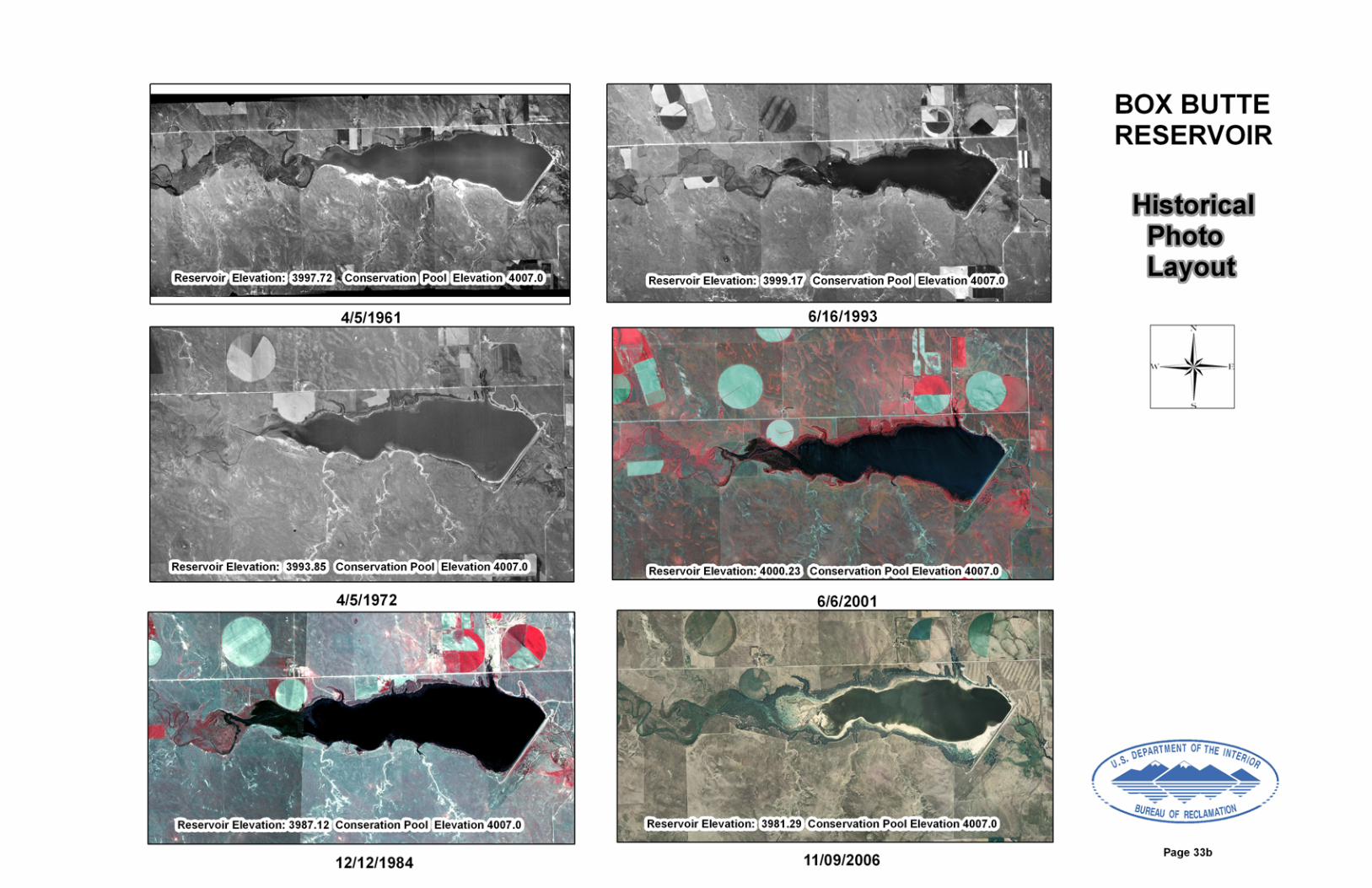
intended use. Generally, this means that Reclamation will only issue a permit or a license, and will not issue leases or easements or other contractual documents that convey an interest in real property. All reservoir lands are currently needed for project purposes and are not available for disposal thru sale, lease, or transfer to any other person, agency, or entity. In the event any of the reservoir lands are determined by Reclamation to be excess to project needs Reclamation will follow standard General Service Administration procedures to dispose of the lands. This process requires that any excess lands be first offered to other Federal or State agencies, then to local counties or municipalities, and lastly thru sale at public auction to the highest bidder. The Commission has the exclusive concession, and licensing rights within the area of the leased premises at Box Butte Reservoir. The Commission will not grant leases or easements or enter into agreements that convey an interest in Reclamation lands to a third party. The Commission may issue and administer licenses, permits, and contracts to persons or associations and may grant concession contracts under which recreation, wildlife and related uses are made available within said areas. However, all new licenses, permits, contracts, or changes to existing licenses, permits, or contracts containing previously unidentified activities, must be submitted to Reclamation for approval prior to execution. The Commission will furnish Reclamation with a fully executed copy of the contract. Land-use classification, land-use changes, and exchange of rights-of-way will be the responsibility of Reclamation. Any major land disturbance or site preparation will have prior approval from Reclamation. The map on page 33a designates land and water use areas. Reports of Serious Accidents and Damages The Commission will provide Reclamation, within 30 days of occurrence, a copy of all reports it requires its field personnel to prepare concerning damage to property and serious accidents occurring within the reservoir area. Property damage includes vandalism to structures, buildings, or other recreation facilities and range or grass fires. Serious accidents to the public include drownings, permanent injuries, and all cases when a claim for injury is filed. Reclamation will then complete a “Security Incident Report” and forward it to Reclamation’s Great Plains Regional Office. Recreation Facilities in Relation to Flood Plain Management The development of recreational areas is closely developed with plans for use of the reservoir storage capacity. Limitations on the location of recreational developments depend upon the surcharge storage operations. The surcharge storage capacity allocation of Box Butte Reservoir includes the storage capacity between elevation 4,007.0 feet above mean sea level(top of active conservation pool) and elevation 4016.0 feet above mean sea level (top of surcharge). There is no designated flood control pool at Box Butte. The top of conservation
35

Chapter 4
storage at 4007.0 ft of elevation corresponds to the crest of the uncontrolled service spillway. The surcharge capacity is above the crest of the uncontrolled service spillway. There is also an uncontrolled auxiliary (emergency) spillway above elevation 4009.0 ft. after the fuse plug washes away. The top of the inactive capacity storage was increased from elevation 3976.5 ft. to elevation 3978.0 ft. in 1990 and to elevation 3979.0 ft. in 2000. The increase is based on an agreement (effective until 2025) between the Mirage Flats Irrigation District, the Commission and Reclamation for a minimum pool reservoir elevation. (See Appendix A5) Although Box Butte is not a flood control storage reservoir, all cabins, group camp developments, and any buildings designed for human habitation, must be constructed above the top of the surcharge elevation (4016.0 feet). For further information and specific guidelines, refer to Executive Order No. 11988, WRC Flood Plain Management Guidelines (43 CFR 6030), and Water and Power Flood Plain Final Procedures (45 CFR 1693). All water supply well construction will comply with State health regulations. Domestic water systems, toilets, and sewage disposal systems will be constructed and operated under the requirements of local and, State public health departments, and Federal health agencies. All garbage and trash collected is to be hauled to an approved county sanitary disposal site. Garbage dumps and refuse disposal areas, ans sites will not be located on reservoir lands. All garbage and trash collected is to be hauled to an approved county sanitary disposal site. The need for construction of boat docks and ramps, bridges, and similar facilities at the reservoir is recognized. Plans showing proposed construction of recreation facilities and their location in the reservoir will be submitted to Reclamation for approval before construction of these facilities. Recreation Use Data Report The Commission will submit to Reclamation, a “Recreation Use Data Report” no later than February 1st for each year during the term of the lease for each separate reservoir area. The report contains two parts: Part 1 is to be completed by the Commission for each reservoir area and Part 2 is to be completed by the concessionaire, if one exists. The report form will be provided by Reclamation. The purpose of this report is to maintain a current inventory of recreation facili-ties that are available for public use, record annual visitation by principal interest and water-craft use, and record fish and wildlife use. Reclamation collects the information and enters it into a database. Reservoir Reviews Upon the request of either Reclamation or the Commission, both parties will meet
36
Agency Responsibility
to review the administration and management of the reservoir area. Local representatives from both agencies will meet annually to review reservoir activities and resolve any outstanding issues. Reclamation prepares and submits a report of the review to all participating agencies within 60 days after the field review. The review and report covers conditions of the lands and facilities, accomplishments, problems, coordination of areas of dual responsibility, and recommendations. Recommendations requiring action by the Commission or Reclamation will be completed within the time schedule as set and agreed upon by both agencies. Changes in Resource Management Plan The Commission or Reclamation may find that certain conditions or situations at Box Butte Reservoir have developed which requires a revision in the RMP. The preparation and acceptance of this plan is based upon mutual approval of purposes and objectives of the agencies responsible for management of the area. Likewise, changes approved by Reclamation require agreement by all agencies concerned. If Reclamation or the Commission fails to approve the RMP or any revisions within 90 days, an additional 90 days can be obtained upon written agreement by Reclamation and the Commission to resolve the differences. A revision of the plan may be proposed by an agency directly involved in the administration and management of the area. The suggested revision should be submitted in writing and should contain a statement outlining the problem and the revision or addition of offset or correct the deficiency. To ensure uniformity and simplicity in handling the revisions or supplements to the RMP, all proposals should be sent to Reclamation. Reclamation will then forward proposals to the other agencies that are signatories to the RMP and will seek their approval. Upon approval of a revision or a supplement to the RMP, Reclamation will furnish copies of revisions or supplements to all agencies that have been furnished copies of the RMP. Trespass Boundary Trespass The Commission shall control and prevent illegal trespass on lands and water surface under its lease. Upon observance by either the Commission or Reclamation, it will be the responsibility of the observing agency to bring this trespass to the attention of the other agency. Through mutual effort, the agencies will decide on a course of action. If legal action becomes imminent, Reclamation shall have the lead responsibility for resolving the trespass. Unauthorized or Improper Use Should unauthorized or improper use occur within the boundary of leased lands the responsibility is of the Commission. Examples include unauthorized dumping of trash or refuse and ORV use. Operations areas or any lands not under lease to
37

Chapter 4
the Commission will be the responsibility of Reclamation and/or the Mirage Flats Irrigation District. Shoreline Jurisdiction The designation of lands at reservoirs with fluctuating shorelines, resulting from irrigation drawdown or increased storage is based on the top of active conservation pool. Lands exposed below this level will be administered by Reclamation or the respective divisions within the Commission. The Parks Division retains jurisdiction of shoreline in front of recreation lands as the water recedes. The Wildlife Division retains jurisdiction in front of the WMA. Reclamation retains jurisdiction of the shoreline in front of the operations areas around the dam; however, the water surface carries a wildlife designation. Consequently, the Commission will follow this policy on lands they administer, and Reclamation will comply on areas they administer. Exceptions to this will be mutually agreed upon between the Commission and Reclamation. Shoreline Erosion The soils in the Box Butte Reservoir area range from deep silt loams along the north side of the reservoir to fine sands along the south side of the reservoir. Top soils contain only a small amount of organic matter and are shallow in numerous areas and completely removed by erosion or excavation in other areas. The shoreline erosion around the reservoir is limited overall but some erosion does occur in isolated areas, which is consistent with erosion patterns experienced at artificial impoundments. Most areas have eroded to a point where they are now stable and been covered by willow and cottonwood growth. Vegetative cover, capable of limiting erosion on the uplands, is generally in excellent condition. This is especially evident when comparing the reservoir land vegetation condition and erosion rates to the surrounding lands that are heavily used for farming and ranching. Erosion occurring on the uplands is caused by both wind and water and is occurring most rapidly and severely on roadways where vegetation has been removed by vehicular travel. Wind erosion losses in these areas are minor due to management practices by the Commission on the WMA and restrictions on driving across highly erodible soils. The Commission is responsible for the control of shoreline erosion near recreation use areas which may threaten public safety. They are also responsible for erecting signs notifying the public of erosion hazards. Reclamation may provide or approve shoreline erosion measures as funding allows in order to improve these conditions. Noxious Weed and Nuisance Plant Species Management As the Federal landowner, Reclamation is ultimately responsible for management of noxious weeds on Reclamation lands and at Reclamation-owned facilities in accordance with the laws and policies in the Federal Insecticide, Fungicide, and Rodenticide Act, Federal Noxious Weed Act, Carlson-Foley Act,
38
Agency Responsibility
and applicable State and local laws and standards. This responsibility is addressed through the Lease agreement, cooperative agreements, and activities involving both Reclamation and the Commission. The lease between Reclamation and the Commission identifies the management responsibilities of the Commission. As part of their land management program, the Commission has the responsibility for identification and correction of noxious weed infestations within the leased premises. The Commission is responsible for noxious weed control at its own cost and expense, which may be supplemented by Federal funds when available. Currently, a cooperative agreement provides Federal funding assistance for chemicals, equipment, and technical assistance to the Commission. The Commission will comply with all provisions of Federal, State, local, and pesticide laws and regulations, as well as the Department of the Interior policies on pesticide use and pest management. A report of noxious weed control programs performed at the reservoir areas, their locations, and treatment methods is provided to Reclamation annually. The Commission’s noxious weed and nuisance plant species control programs are designed to be holistic and comprehensive. The primary goals are to achieve effective control of the target species with the least possible hazard to people, property, and the environment. If control programs are needed, the Commission is responsible for deciding when treatment should be initiated and the frequency of treatment. The Commission will also determine what physical, cultural, biological, mechanical, and chemical treatments (or combinations thereof) to implement, and will also evaluate treatment effectiveness. The Mirage Flats Irrigation District is responsible for managing the lands identified as operations areas and is responsible for noxious weeds and nuisance plant species on those lands, waters and facilities. The District will coordinate efforts with Reclamation’s Area Office noxious weed coordinator. Fire Management Fire Policy According to the lease agreement, “The Commission shall assume the responsibility for assisting in the prevention, control, and suppression of fires on the leased lands” at Box Butte Reservoir and surrounding lands. The Commission shall also be responsible for submitting to Reclamation, a fire management plan identifying and specifying the duties and responsibilities for cooperating entities for fire control on the lands under the lease. The Commission will prepare a fire evacuation plan to accommodate public egress in the event of localized fires. Fire Prevention Fire hazards can be greatly reduced by using management techniques, including construction of firebreaks, planting warm season grasses, and reducing
39
Chapter 4
accumulation of surface organic litter by prescribed burning, high intensity grazing, haying, and plowing. Firebreaks on the reservoir lands include hard topped roads and gravel roads, and fallow, hayed, and cropped fields The Commission plows and maintains a firebreak around all newly planted tree plots in the reservoir area until they become established. Older tree plots are a valuable natural resource, and it is wise to maintain firebreaks around all tree sites for maximum protection. There is no fire suppression equipment available to the public at Box Butte Reservoir. However, Reclamation and the Commission personnel live nearby and are available to assist the volunteer fire departments in fire fighting. Neither the State Fire Marshal nor the rural fire districts conduct annual fire inspections on reservoir lands. To comply with the lease agreement, Reclamation and the Commission inspect all recreation and wildlife lands annually. Fire Suppression Hemingford Rural Volunteer Fire Department (RFVD) is the first responder to Box Butte Reservoir for fire and rescue operations. Assistance is available from Chadron, Crawford and Alliance when requested by the Hemingford RVFD. In addition to these resources, when requested Box Butte and Dawes County Road Departments can make their fire support equipment available, i.e.graders, dozers and large-capacity water tanker trucks. The Commission also has personnel, 4x4 pumper units and other equipment available for wildfire suppression at Box Butte Reservoir. Interagency Cooperative Fire Management Agreement According to the Reclamation Act of 1902 and the Federal Water Project Recreation Act of 1965 (P.L. 89-72) as amended by the Reclamation Recreation Management Act of 1992 (P.L. 102-575), Reclamation entered into an Interagency Cooperative Fire Management Agreement (Appendix A4). The purpose is to document the commitments to fire protection assistance and cooperation on lands in Nebraska. The agreement identifies authorities, roles, and responsibilities of Federal agencies, State agencies, and local entities responsible for fire management and suppression activities in Nebraska. Partners of the agreement include: -United States Department of Interior (USDI), National Park Service, Midwest Region -USDI, Bureau of Indian Affairs, Great Plains Region -USDI, Bureau of Reclamation, Great Plains Region
40

Agency Responsibility
-USDI, Fish and Wildlife Service, Mountain Prairie Region -USDA, Forest Service, Rocky Mountain Region -Nebraska Emergency Management Agency -Nebraska Forest Service -Nebraska Game and Parks Commission -Nebraska Military Department -Nebraska State Fire Marshal Off-Road Vehicle (ORV) Use Reclamation lands are closed to ORV use, except for an area or trail specifically opened to use of ORV in accordance with 43 CFR Part 420. Presently, there are no designated “open” ORV areas at Box Butte Reservoir. Prior Rights Prior rights that are identifiable, all of which are contractual obligations of Reclamation, are listed in chapter 1, “Prior Rights and Reservation.” Other prior rights, if any, which existed at the time of acquisition of the lands by Reclamation, are not readily identifiable. The exercising of rights that existed prior to transferring the administration of Box Butte Reservoir lands to the Commission will require formalization by the granting of a license, permit, or easement. Land Use Authorizations Reclamation is authorized to execute use authorizations on lands and water surfaces under its jurisdiction. A use authorization is a documented, authorized use of Federal lands. The issuance of use authorizations such as easements, permits and licenses for activities on or across Reclamation lands may only be considered when the proposed use of lands or facilities is compatible with project purposes and consistent with this Resource Management Plan. Reclamation will consult with the Commission on any proposed use on a case by case basis. Reclamation prohibits any new exclusive private/semi-private use of Reclamation lands unless directed otherwise in specific authorizing legislation. Reclamation may only authorize private access roads or gates when no reasonable access exists and where compatible with Reclamation project purposes. Current Box Butte Reservoir Land Use Authorizations: -License for Operation, Maintenance, and use of a Cattle Water Gap on Fee Simple Lands of the United States of America. This license was issued to Carl E. and Iris L. Wilkins on July 25, 2006 for the purpose of operation, maintenance, and use of a cattle water gap in the SE1/4NE1/4 of Section 26, T.29N., R.50W., Dawes County, NE at the west end of Box Butte Reservoir on the north bank of a tributary of the Niobrara River, containing approximately 4.8 acres. The prior conveyance of Donation Grant of Easement Contract No. 06-LA-60-5752 by the licensee to the United States is complete consideration for the grant of this license. The term of this license is for a five year period with the option to request
41

Chapter 4
renewal. This license is not transferable to other parties, heirs, successors, or assignees. -License for Construction, Operation, and Maintenance of Irrigation Pump, Irrigation Power unit, and Underground Irrigation Service and Electrical Supply Line Across Fee Simple Lands of the United States of America. This license was issued to Dan Campbell on August 22, 2008 for the purpose of operating and maintaining an irrigation pump site in the SW1/4 of Section 26, T.29N., R.50W., Dawes County, NE at the west end of Box Butte Reservoir on the north bank of the Niobrara River, containing approximately 1.5 acres. This license is a renewal authorization for an existing facility. The term of the license is for a period of ten years. This license is not transferable to other parties, heirs, successors, or assignees. Other Agreements: -Memorandum of Agreement Between Bureau of Reclamation and Nebraska Game and Parks Commission and Steve Klaes for Land Management Purposes at Box Butte Reservoir. This MOA was entered into by all parties on June 27, 2008 for the purpose of establishing a framework where the parties agree to work to resolve land related issues at Box Butte Reservoir. Lands within the S1/2 of Section 29; the S1/2 of Section 30, Township 29 North, Range 49 West; a parcel of land in the SE1/4SE1/4 of Section 25,and a parcel of land in the SW1/4SW1/4, Township 29 North, Range 50 West of the 6th P.M, Dawes County, Nebraska were made to the specific elevation of 4012’ and were not acquired by legal subdivision. In the S1/2 of Section 29, the S1/2 of Section 30 and the SE1/4 of Section 25 where the take line was to elevation 4012’ Reclamation did not construct a boundary fence. Although some fences were later constructed, it is known that they do not follow Reclamation’s surveyed property line. These fences were constructed for ease of management and convenience to Reclamation and to prevent unauthorized livestock grazing and illegal trespass by reservoir users onto adjacent private lands. This MOA contains responsibilities by all parties. It is in effect for a period of ten years. This MOA is not assignable or transferable to any other party. -Memorandum of Agreement Between Bureau of Reclamation and Nebraska Game and Parks Commission and Valentin (Vic) Rivera for Land Management Purposes at Box Butte Reservoir. This MOA was entered into by all parties on June 27, 2008 for the purpose of establishing a framework where the parties agree to work in an amicable manner to resolve land related issues at Box Butte Reservoir.
42

Agency Responsibility
Lands within the NE1/4 of Section 25., T29N., R50W and the NW1/4 of Section 30, T29N., R49W West of the 6th P.M, Dawes County, Nebraska were acquired for the construction of Box Butte Reservoir. Acquisition of these lands was made by legal subdivision. It has been determined that the boundary fence, constructed to prevent unauthorized livestock grazing on riparian areas of Box Butte Reservoir and to prevent illegal trespass by reservoir users onto adjacent private lands, is not located upon, nor does it define United States property boundaries. This MOA contains responsibilities by all parties. It is in effect for a period of ten years. This MOA is not assignable or transferable to any other party. Rights Not Directly Related to the Development and Administration of the Reservoir Lands for Recreation and Wildlife and Related Uses The administration of lands and water at Box Butte Reservoir was transferred to the Commission to permit exclusive responsibility, operation, control, and administration of these lands for recreation, fish and wildlife, and related uses. Use rights not directly related to administration or development of the lands for such purposes shall be granted by Reclamation. Examples of such use rights are State and county roads, rights involved in serving Reclamation facilities, transmission lines, telephone lines, and other facilities which cross reservoir lands, but serve lands or persons outside of the reservoir area. Removal of Nonrenewable Resources By law, Reclamation cannot allow a State or local agency to sell or permit the removal by others of nonrenewable resources such as sand, gravel, stone, oil, and gas. Permits for exploration and/or removal of Reclamation-acquired minerals (other than fossil fuels) are the responsibility of Reclamation. When reserved mineral rights are to be exercised by the previous or former owner(s), Reclamation will require an exploration or mining plan be prepared and submitted for its review and approval. Written approval of Reclamation will be required prior to the start of any related work. Removal of Renewable Resources No trees or shrubs will be cut, removed, or destroyed without the prior approval of Reclamation and the Commission. No grasses (native or seeded) will be plowed or destroyed without the prior approval of Reclamation and the Commission. Use Rights to be Granted by the Administering Agency The Commission may not issue any type of use athorization that conveys a real property interest, nor may they lease or dispose of any interest of the United
43
Chapter 4
States. The Commission may grant permission to third parties for other use rights. Examples of uses requiring licenses, permits, or contracts are agricultural and grazing privileges, powerlines not in excess of 15 kilovolts (KV), and telephone lines which are directly associated with recreation and wildlife development within the reservoir area. The location and general construction plans for proposed roads, powerlines, pipelines, and telephone lines shall be submitted to Reclamation for approval, prior to granting permission to construct such facilities. This requirement permits Reclamation to determine whether the location and construction may damage, or threaten to damage, the property of the United States, have significant environmental impact, or interfere with the operation of the dam and reservoir. Execution and administration of licenses, and permits is the responsibility of the Commission. However, the Commission shall receive written approval from Reclamation for the contract prior to executing it. Also, the Commission shall carry adequate public liability insurance customary under the existing circumstances and shall require all concessionaires, permittees, and licensees to carry public liability insurance. Leasable Minerals Subject to Reclamation's review, and in coordination with the Bureau of Land Management (BLM), minerals owned by the United States at Box Butte Reservoir are generally available for mineral leasing. Although BLM is the lead agency responsible for issuing mineral leases they are required to consult with the surface managing agency prior to issuing any mineral leases at Box Butte Reservoir. Reclamation requires BLM to attach a copy of Reclamation's GP-135 Special Stipulations to any lease that BLM may issue (see Appendix B2 for GP-135 Special Stipulations). These stipulations require certain setbacks and other restrictions designed to protect public recreation areas, water resources, and Reclamation project facilities from adverse impacts associated with mineral development. Additionally, it is Reclamation policy to consult with its managing partner and to consider any concerns they may have prior to Reclamation advising BLM whether or not a mineral lease should be issued. All of the minerals under Box Butte Reservoir are owned by the United States. Health and Safety It is the responsibility of the Commission to report all public health and safety hazards on Box Butte Reservoir lands they manage. Examples would include but not limited to: substandard facilities, contaminated water systems, sunstandard septic systems, unsafe roads, dangerous boat ramps, substandard electrical wiring, dangerous canals, and unsafe bridges. Hazards or deficiencies reported by the Commission which fall within their area of responsibility should be corrected or eliminated as soon as possible. Likewise, Reclamation should correct health and safety hazards and deficiencies on the lands they administer as soon as possible.
44

Agency Responsibility
Threatened and Endangered Species The U.S. Fish and Wildlife Service (FWS) is the lead Federal agency responsible for the protection of threatened and endangered species. However, Reclamation has the ultimate responsibility for the protection of threatened and endangered species and critical habitat on lands at Box Butte Reservoir. Under the terms of the lease the Commission is required to comply with the Endangered Species Act. Assistance in protection, enhancement, and enforcement will be available through the Commission and Reclamation personnel. State and Federal law prohibits harassment of threatened and endangered species. The Commission shall take all reasonable precautions to assist in the prevention and control of disturbances to threatened and endangered species on Box Butte Reservoir lands. Any violations shall be promptly reported to the FWS and Reclamation. Currently, no critical habitat has been designated at Box Butte Reservoir. If at some time critical habitat is designated by the FWS, Reclamation must concur with any plan to provide for additional protection or enhancement by the Commission. Reclamation will assist with planning or implementing protective measures, if needed. Cultural Resources Reclamation is responsible for identifying and protecting historical, archaelogical, architectural, scientific, and paleontological resources affected by Reclamation actions on lands under its administration. The Commission shall control and prevent damage to cultural resources on lands, reservoir waters, and stream bottoms at Box Butte Reservoir. Cultural resources are defined as historical, archeological, or paleontological (fossil-bearing) sites. Prohibited activities which are damaging to the resources include intentional and incidental vandalism (unauthorized excavation or other ground altering activities), and removal of any item, object, or material of cultural or scientific significance from its position on the ground. This includes arrowheads and other prehistoric artifacts, wood from decayed structures, bottles, ceramics and fossils. Vandalism includes not only surface removal of artifacts, but also the excavation of cultural resource sites; such as digging holes in cultural resource sites for the removal of artifacts or paleontological material. Upon observance by representatives of either the Commission or Reclamation of damage to cultural resources, or the discovery of cultural resources previously unknown or undiscovered, it shall be the responsibility of the observing agency to bring this violation or discovery to the attention of the other agency. Reclamation will then notify the Area Archeologist by telephone. Through mutual effort, the agencies will decide on a course of action. If legal action becomes imminent, Reclamation will have sole responsibility for resolving the problem. Any surface
45

Chapter 4
disturbance shall require written cultural resource clearance from Reclamation’s Area Office Archeologist. In addition, all Federal agencies are directed to assume leadership in protecting and preserving the cultural resources of the Nation. This authority was first mandated by the Antiquities Act of 1906 (16 U.S.C. 431). Subsequent legislation includes the following: *Historic Sites Act of 1935 (16 U.S.C. 461) *Reservoir Salvage Act of 1960 as amended (16 U.S.C. 469) *National Historic Preservation Act of 1966 as amended (16 U.S.C. 470) *National Environmental Policy Act of 1969 as amended (42 U.S.C. 4321) *Archeological and Historic Preservation Act of 1974 (16 U.S.C. 469) *American Indian Religious Freedom Act of 1978 (42 U.S.C. 1996) *Archaeological Resources Protection Act of 1979 as amended (16 U.S.C. 470) *Native American Graves Protection and Repatriation Act of 1990 (25 U.S.C. 3001) *National Register of Historic Places (36 CFR Part 60) *Determinations of Eligibility for Inclusions in the National Register of Historic Places (36 CFR Part 63) *Curation of Federally Owned and Administered Archeological Collections (36 CFR Part 79) *Protection of Historic Properties (36 CFR Part 800) *Protection of Archaeological Resources (43 CFR Part 7) *Native American Graves Protection and Repatriation Act (43 CFR Part 10) *Protection and Enhancement of Cultural Environments (Executive Order 11593) *Protection of American Indian Sacred Sites (Executive Order 13007) *Preserve America (Executive Order 13287), and *The Secretary of the Interior’s Standards and Guidelines for Archeology and Historic Preservation: (48 FR 44716). The scope of these preservation laws is expressed in Executive Order No. 11593, which directs all Federal agencies to inventory and evaluate cultural resources on lands they administer and nominate to the National Register of Historic Places those sites meeting the criteria of the National Register (36 CFR 60). Federal agencies are directed to exercise prudent and responsible management of all cultural resources. Reclamation is responsible for identifying and protecting historical, archeological, architectural, scientific, and paleontological resources affected by Reclamation actions on lands under its administration.
46

Agency Responsibility
Environmental Compliance Any action involving Federal funding or approval is subject to the requirements of NEPA and other environmental statutes. The initial screening for environmental compliance will take place commensurate with Reclamation’s participation. Any additional analysis will be the responsibility of the Commission in cooperation with Reclamation. Reclamation will determine, on a case-by-case basis, the level of analysis, interagency coordination, public involvement, documentation, and other compliance activities needed prior to granting such funding or approval. The responsibility for accomplishing such analysis and related activities will be determined by Reclamation in consultation with the Commission. Miscellaneous Aircraft The operation of aircraft on lands or waters at Box Butte Reservoir is prohibited. Except in extreme emergencies involving the safety of human life or threat of serious property loss, the air delivery of any person or item by parachute, helicopter, or other means without written permission of Reclamation’s Great Plains Regional Director and the Commission, aircraft operation is prohibited. The provisions of this section are not applicable to aircraft engaged in Reclamation’s official business, used in emergency rescue at the direction of the Great Plains Regional Director, or a forced landing due to circumstances beyond the control of the pilot. Nothing in the preceding provisions gives authority to deviate from rules and regulations or prescribed standards of the appropriate State aeronautical agency or the Federal Aviation Administration including, but not limited to, regulations and standards concerning pilot certifications or ratings and airspace requirements.
47
Chapter 4
48
Facilities Detailed site plans showing proposed construction of recreation facilities, their location in the reservoir area, and accompanying construction specifications shall be submitted to Reclamation for approval before construction of these facilities is initiated. Shooting Ranges Because of increased concerns associated with the contamination and cost of cleanup and remediation of hazardous wastes associated with shooting ranges, Reclamation will not allow construction of these facilities at Box Butte Reservoir.