chapter 4 - land use characteristics central/2013-alpena hazard mitig… · chapter 4 - land use...
TRANSCRIPT
Alpena County 2013 Hazard Mitigation Plan
4-1
Chapter 4 - Land Use Characteristics
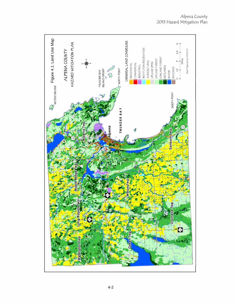
The Alpena County Existing Land Use Map shows urban land uses are concentrated in the City of Alpena and regions of Alpena Township in close proximity to the City. Commercial development is concentrated in the city’s downtown and along highways within the city and adjacent township. Industrial development is located in the northern parts of the city and adjacent township areas. A truck route plan and road improvements have removed trucks from residential areas, therefore reducing possibility of HAZ/MAT incidents. The rest of the County is either agricultural with family farms, forested with low-density residential or hunting camps, lakes with shoreline housing, and wetlands. The county’s population density is 52 persons per square. When the county’s urban population is subtracted, population density drops to less than 19.5 persons per square mile. Existing Land Use Categories The map of existing land use, Figure 4-1, illustrates distribution of land uses types throughout the County. Figure 4.2 depicts public and private land ownership in Alpena County. Public lands comprise approximately 12 percent of the county's total land area. The Michigan Resource Information Systems (MIRIS) land cover/use classification categories were developed to map existing land uses. Residential Residential land use designation includes types such as: single family or duplexes, multi-family low rise residential, multi-family medium & high rise residential, and mobile home parks. The largest concentration of residential development is located in the City of Alpena and around its periphery in Alpena Township. Smaller concentrations of residential development are found around the community centers of Ossineke, Hubbard Lake and Lachine. Waterfront areas have high concentrations of residential development that combines newer building with transition of seasonal cabins to year-round homes. Almost all of the shoreline of Long Lake in Alpena County has experienced residential development. Mud Lake (Sunset Lake), Lake Winyah, Beaver Lake and portions of Thunder Bay River have concentrations of residential development. Residential development can be found along the Lake Huron shoreline at Partridge Point peninsula, south of Squaw Bay to Ossineke, and Huron Bay south to Potter Point. Within the interior of the county, residential development is occurring along county roads as larger parcels are split into 0 acre and smaller parcels. Commercial Commercial land use includes classifications related to sales and services, such as: central business districts, shopping centers/malls, strip commercial, and neighborhood compact groups of stores that are surrounded by noncommercial uses. This category includes parking areas related to the commercial businesses. Commercial uses are primarily found in the City of Alpena along M-32 and U.S. 23 North, on U.S. 23 South in Alpena Township, and in Sanborn Township in the unincorporated community of Ossineke. Small nodes of commercial uses can be found scattered throughout the county, usually located at primary crossroads. These establishments are generally convenience commercial stores that cater to local residents and tourists.
Alpena County 2013 Hazard Mitigation Plan
4-2
Fig
ure
4.1:
Lan
d U
se M
ap
Alpena County 2013 Hazard Mitigation Plan
4-3
Industrial/Extractive/Transportation Industrial land use includes extractive industries, manufacturing and industrial parks, light industries that fabricate or package products, oil & gas drilling and production facilities, lumber mills, chemical plants, brick-making plants, large power facilities, waste product disposal areas, areas of stockpiled raw materials, and transportation facilities. Much of the industrial land use is comprised of the Lafarge Corporation quarry and cement processing facility. Other large areas of industrial uses are the Alpena Regional Airport and the Paxton Quarry in Rockport. Institutional/Recreational Institutional/recreational land use includes a variety of classifications such as education, government, religious, health, correctional, and military facilities; indoor and outdoor recreational facilities; and cemeteries. Buildings, parking areas, and immediate grounds are included in this category, however, all surface water, forest, barren land, and wetlands associated with these facilities are entered into their own respective categories. Alpena Community College, Alpena General Hospital, Alpena High School and facilities and the Combat Readiness Training Center make up the majority of this land use. Agricultural Agricultural land use generally includes land that is used for production of food and fiber but also includes land used for non-food livestock such as horses. Agricultural classes are: cropland, orchards, confined feeding operations for livestock of any kind, permanent pasture lands, farmsteads, greenhouse operations, and horse training areas. A majority of agricultural uses are found, not surprisingly, on prime agricultural soils that generally bisect the county from northwest to southeast. Wilson Township, Ossineke Township and Long Rapids Township have the largest extent of agricultural land use. Nonforested Uplands Nonforest land use includes “open land” and rangeland classifications such as barren land, herbaceous open land, and shrubland. Herbaceous open land is usually subjected to continuous disturbance such as mowing, grazing, or burning, and typically it can have a variety of grasses, sedges, and clovers. Shrubland is land in transition from open to becoming an eventual forest. Native shrubs and woody plants include blackberry, raspberry briars, dogwood, willow, sumac, wild cherry and serviceberry. Nonforest land consists largely of abandoned farms or to a minor extent clearings resulting from logging operations or reclaimed mining areas. Typical grass species found in these areas are quackgrass, brone grass, upland and lowland sedges, red canary grass and clover. Upland Forest Forest land use areas are generally at least 10% stocked by trees of any size. Upland forest category includes deciduous species like maple & beech, aspen, birch, and upland conifers such as red, white or jack pine, white spruce, blue spruce, eastern hemlock, and balsam fir. . Lowland Forest Lowland forest areas are dominated by species that grow in very wet soils. Lowland deciduous species include ash, elm, red maple and cottonwood. Lowland conifers include cedar, tamarack, black and white spruce, and balsam fir. The lowland forest is the largest land use in the county. Wetlands Wetlands are those areas where the water table is at or near land surface for a significant part of most years. Examples of wetlands are marshes, mudflats, wooded swamps, shallow areas

Alpena County 2013 Hazard Mitigation Plan
4-4
along rivers or lakes or ponds. Wetlands areas include both non-vegetated mud flats and areas of hydrophytic vegetation. Surface Water Alpena County’s surface water category includes lakes, reservoirs, impoundments, ponds, rivers, and streams. Surface water covers approximately 13,032 acres or 3.28 percent of the county. Fletcher Pond, Long Lake, Lake Winyah, Devils Lake, Beaver Lake, Turtle Lake, Grass Lake, Middle Lake, Mud Lake and the three branches of the Thunder Bay River are the major surface waters in the county. Planning and Zoning The City of Alpena and all townships except Wellington have exercised their authority under state statutes to administer their own planning and zoning. In January of 2000, Alpena County reestablished a County Planning Commission after being dissolved in 1985. Since local jurisdictions have chosen to administer their own zoning, the county does not administer zoning at the county level. Planning and Zoning are the principal tools that local communities have to manage growth, preserve community character, protect property values and enhance the economic viability of the area. Planning helps establish and focus the desired future of the community and zoning ordinances are used as one of the primary ways to implement the community master plan and achieve the goals of the community. A key element of the community master plan is the future land use plan. This is the culmination of the planning process that entails an analysis of existing conditions, public input and goal setting, and finally establishing the community’s desired future. The community-wide future land use plan includes a map that depicts where the community envisions types and densities of development. As well, the plan may address important resource areas to protect. Accompanying text describes future land use categories, compatible uses, incompatible uses and development densities. Special issue areas may include utility service areas, roads, open space development and waterfront development. The future land use plan is a policy document designed to guide land use decisions over a given planning horizon, usually 20 years. By comparison, the zoning ordinance and zoning map is a local law that regulates how property can be developed today. Land-use planning and zoning are governmental functions critical to public safety. However, because these functions are political as well, they are subject to intense differences of opinion and to public controversy. Therefore, they tend to lag behind development until the problem becomes aggravated. Being political they are also subject, even after enactment into law, to pressures for variances and modifications. With few exceptions, they cannot be made retroactive and, consequently, older developments are not much affected by them. Where land-use planning and zoning have been enforced, however, they have achieved significant degrees of fire safety (Oreg. St. Dep. For. 1978b, San Bernardino County Bd. Sup. 1974). While building codes provide guidance on how to build in hazardous areas, planning and zoning activities direct development away from these areas, especially floodplains and wetlands. They do this by designating land uses that are compatible to the natural conditions of the land, such as open space or recreation in a flood plain, or by simply
Alpena County 2013 Hazard Mitigation Plan
4-5
allowing developers more flexibility in arranging structures on a parcel of land through the planned development approach. Capital improvement plans guide major public expenditures for communities for the next 5 to 20 years. Capital expenditures may include creating access roads and fire breaks, hazardous fuels reduction projects including community vegetation management, vegetation removal, and vegetation clearing and/or thinning, and retrofitting existing public structures against wildfire, etc. Master plans, including the future land use plan, are implemented through zoning, capital improvement programs and recreation planning. Zoning is the primary tool used by most communities to implement their master plan. Zoning regulates the type, intensity and location of development in a community. As such, zoning provides communities a means to implement hazard mitigation strategies for land use development, which may include standards for private/public road construction; driveway standards; requirements for developments (such as subdivisions, condominium, commercial, recreational and industrial) to have two egress ingress roads; and house addresses to be displayed on 911 signs at the driveway end.
Another important zoning tool available to communities is the Planned Unit Development (PUD). Use of PUDs provides flexibility to both the community and developer to incorporate Firewise development standards. In high risk areas, PUD standards should include use of defensible zones, fuel breaks, road and driveway design, signage for street identification, ingress and egress roads, underground utilities and vegetative maintenance for managing dangerous fuel loads in high fire risk areas. Identified Hazardous Land Uses and Areas The Alpena County Hazard Map (Figure 4.xx) indicates areas and land uses that may have increased hazard potential. Hazards shown on this map are oil and gas wells, high-risk forest areas, flood prone areas, main transportation routes, critical facilities and infrastructure, contaminated sites, and dams. Residential areas were also included on the map to identify vulnerable population areas and property. Oil and Gas Wells As of January 2003, over 750 oil and gas wells have been drilled in Alpena County. Gas is the predominant resource being extracted, and 631 wells were currently producing gas. There are 35 brine disposal wells and one oil well. The remainder of the wells are dry holes that are plugged or in the process of being plugged. The majority of the wells are located in the southwest area of the county. The largest number of wells is located in Ossineke, Green and Wilson Townships. Approximately 25 wells are located in Sanborn Township and 8 wells are located in Alpena Township. Maple Ridge, Long Rapids and Wellington Townships each have less than 5 wells. High Risk Fire Areas Areas with increased wildfire risk were mapped using 1978 MIRIS land cover data. Highly flammable fuel sources such as stands of Jack Pine, Red Pine and Red Oak were identified and shown in yellow on the Hazard Map. The largest concentrations of high-risk areas are located
Alpena County 2013 Hazard Mitigation Plan
4-6
in the southeast corner of the county in Ossineke Township. Other areas of high fire risk can also be found in Wilson and Alpena Townships, primarily in the State Forest. Dams There are five dams located in Alpena County. Of primary concern are Norway Point dam and 4 mile dam located in Maple Ridge and Alpena Townships respectively. Both dams are approaching 100 years old and are upstream from large concentrations of population and critical infrastructure. Contamination Sites Sites that contain hazardous waste, sites of environmental contamination, and oil and gas contamination are indicated on the hazard map. Some of the data shown is more than 10 years old at the time the map was prepared and should not be considered as a definitive source on all contamination sites in the county. Flood Prone Areas Flood prone areas included on the hazard map are areas that are in the 100 year flood hazard area as delineated on the Flood Insurance Rate Map and soils identified on the Soil Survey Geographic data prepared by the USDA Natural Resource Conservation Service as having a 50% chance of flooding each year. Also areas known locally to have flooding problems have been identified on the map.

Alpena County 2013 Hazard Mitigation Plan
4-7