chapter 4. water resources - chamorro.com · guam and cnmi military relocation ... army amdtf 4-1...
TRANSCRIPT

Guam and CNMI Military Relocation Final EIS (July 2010)
VOLUME 5: ARMY AMDTF 4-1 Water Resources
CHAPTER 4. WATER RESOURCES
4.1 INTRODUCTION
Water resources as defined in this Environmental Impact Statement (EIS) are sources of water available for use by humans, flora, or fauna, including surface and groundwater, nearshore waters, and wetlands. Surface water resources, including but not limited to lakes, streams, and rivers, are important for economic, ecological, recreational, and human health reasons. Groundwater may be used for potable water, agricultural irrigation, and industrial applications. Groundwater is classified as any source of water beneath the ground surface, and is the primary source of potable water used to support human consumption on Guam. Consistent with the definition contained in 22 Guam Administrative Regulations 5105, nearshore waters are defined as all coastal waters lying within a defined reef area, all coastal waters of a depth of less than ten fathoms (60 feet [ft], 18.3 meters [m]), and all coastal waters greater than 10 fathoms up to 1000 ft (305 m) offshore where there is no defined reef area. Nearshore waters can be directly affected by human activity, and are important for human recreation and subsistence. Wetlands are habitats that are subject to permanent or periodic inundation or prolonged soil saturation, and include marshes, swamps, and similar areas. Areas described and mapped as wetland communities may also contain small streams or shallow ponds, or pond or lake edges.
This chapter describes the potential environmental consequences for water resources associated with implementation of the alternatives within the region of influence (ROI). For a description of the affected environment for all resources, refer to the respective chapter of Volume 2 (Marine Corps Relocation – Guam). The locations described in Volume 2 include the ROI for the Army Air and Missile Defense Task Force (AMDTF) component of the proposed action, and the chapters are presented in the same order as the resource areas contained in this Volume.
4.2 ENVIRONMENTAL CONSEQUENCES
4.2.1 Approach to Analysis
4.2.1.1 Methodology
This section contains a discussion of potential environmental consequences associated with implementation of the alternatives within the ROI for water resources. The environmental consequences of each alternative and the no-action alternative are presented in this section. The available literature was used to assess the existing conditions and to establish a baseline for the assessment, as described in the affected environment section (Volume 2, Chapter 4, Section 4.1). The methodology for identifying, evaluating, and mitigating impacts to water resources have been established based on federal and local laws and regulations as described in Volume 2, Chapter 4, Section 4.1.
The environmental consequences evaluation for water resources includes a qualitative and quantitative analysis of surface water, groundwater, nearshore waters, and wetlands to the extent possible given available project data. Environmental impact assessments were made and compared to baseline conditions, items of public concern, and significance criteria to determine the magnitude of potential impacts to water resources.
The proposed action analysis is separated in two main activities: construction and operation (consisting of non-training and training operations). Each of these activities has potential effects with associated

Guam and CNMI Military Relocation Final EIS (July 2010)
VOLUME 5: ARMY AMDTF 4-2 Water Resources
impacts. The analysis of potential impacts considers both direct and indirect impacts. Direct impacts are those that may occur during the construction phase of the project and cease when the project is complete or those that may occur as a result of project operations following the completion of construction. Indirect impacts are those that may occur as a result of the completed project or those that may occur during operations but not as a direct result of the construction or operational action.
Implementation of the proposed action would be consistent with Navy policy in compliance with laws and executive orders whereby Department of Defense (DoD) entities are required to reduce demand for indoor water by as much as 20% and outdoor water use by 50% in the coming years. Concurrent with these mandates is the Navy/Marine Corps policy to pursue and facilitate Leadership in Energy and Environmental Design (LEED) Silver certification for their facilities. LEED is a voluntary point system tool that measures the degree of sustainability features incorporated into a development.
Sustainability Requirements and Goals
Water resource sustainability is addressed in two categories: minimize water demand and maximize the quantity and quality of groundwater recharge. Elements identified to achieve minimum water use are:
• Water Conservation - identify and specify appropriate minimum water demand fixtures and devices
• Irrigation - minimize use of irrigation systems and water • Grey Water Use - evaluate options for use of grey water for irrigation • Rainwater Harvesting - investigate harvesting, storage, and distribution systems
The quantity and quality of groundwater recharge is addressed in the existing Unified Facilities Criteria Low Impact Development (LID) Manual that would be followed. This manual includes specific Integrated Management Practices (IMPs) to be considered and included in the drainage design of the proposed action sites. In addition, National Pollutant Discharge Elimination System (NPDES) permitting requirements, LEED goals, and DoD policy in response to recent executive orders and acts (e.g., the Energy Independence and Security Act of 2007), mandate certain drainage quantity and quality performance standards. Thus, the proposed action includes incorporating post-construction drainage quality, quantity, and velocity dissipation measures to approximate (or improve upon) pre-construction conditions at the property line.
Surface water issues include:
Surface Water/Stormwater
• Water quality • Flooding • Flow path alterations
Surface water quality impacts are evaluated by examining the potential increase of contamination including chemicals, heavy metals, nutrients, and/or sediments in the surface water as a result of the proposed action. The analysis is performed by comparing existing water quality data with possible increases in water quality contaminants in the surface water. Potential impacts to surface water quantity and velocity are analyzed by examining changes in drainage volumes and patterns associated with the proposed action. For construction activities, some of the key effects include stormwater discharges that may contain elevated sediment concentrations, and spills and leaks of chemicals such as lubricants, fuels, or other construction materials that may increase pollutant loading in to the surface water. In addition, direct construction or alteration of stream channels or reservoirs may cause increased contamination by

Guam and CNMI Military Relocation Final EIS (July 2010)
VOLUME 5: ARMY AMDTF 4-3 Water Resources
sedimentation or chemical constituents. If flow paths or patterns are altered, additional studies, such as instream flow analysis, would be conducted to ensure the human uses and/or biological services are preserved.
For non-training operation activities, effects include stormwater discharges which may increase the volume of sediment loading to the surface water as well as increase contaminants from vehicle maintenance, household discharge, privately-owned vehicles, and animal waste. Contamination of surface water from leaks or spills of hazardous, or otherwise regulated materials, is also a potential impact. Increased water usage may reduce the water availability in the reservoirs and/or reduce instream flows. Increased impervious areas may increase the runoff and increase the potential for flooding. Development in the floodplain may result in potential damage from flooding. Diversion of water courses for municipal water consumption may impact the ecological services that the resource provides. Training operation activities include potential contaminants from range and course training activities. For example, vehicle traffic could result in an increase in runoff due to the removal of ground cover. The storage of hazardous materials and fuels pose a continued risk of contamination for surface water from leaks or spills.
Groundwater impact concerns include water quality and water quantity. The potential for impacts to groundwater quality was assessed by examining the risk of a hazardous or regulated waste release, as well as approximating the amount of additional stormwater and associated non-point source pollution that would enter the groundwater as a result of the proposed action. The groundwater quality impact analysis was performed by comparing existing groundwater quality data with possible increases in water quality contaminants in the groundwater.
Groundwater
Water availability is addressed in Volume 6, Chapter 3, Section 3.1. Potential groundwater impacts associated with construction activities include direct spills and leaks having direct impacts to stormwater runoff that can contribute to groundwater contamination, well as direct contamination of groundwater resources through percolation
The effects connected with the non-training operation activities include increases in impervious surfaces, waste generating activities, storage of potential contaminants, and landfill leaching. The direct impacts include an increase in polluted stormwater runoff and contamination from leaks or spills of hazardous or regulated materials. In addition, the increased water usage may increase the rate of depletion of groundwater resources. The indirect impacts may include decreases in groundwater recharge due to an increase in impervious areas. Saltwater intrusion can also occur if over-pumping the water supply wells draws seawater into the aquifer.
The possible impacts connected with operations include increases of impervious areas, waste-generating activities, storage of potential contaminants, and landfill leaching. The direct impacts include an increase in polluted stormwater runoff and contamination from leaks or spills of hazardous or regulated materials. The effects related to the training operations include contamination from expended training materials, discharges from latrines, and leaks or spills from hazardous materials. These training activities can pose both short-term and long-term effects.
The nearshore water impact analysis focuses on water quality. Recreational nearshore issues are addressed in Chapter 9, Recreational Resources. The potential increases of contamination including chemicals, heavy metals, nutrients, and/or sediments in nearshore waters as a result of the proposed action are assessed by comparing existing water quality data with the projected changes in water quality.
Nearshore Water

Guam and CNMI Military Relocation Final EIS (July 2010)
VOLUME 5: ARMY AMDTF 4-4 Water Resources
Potential impacts associated with construction activities include construction spills and leaks that may discharge to nearshore waters and an increase in stormwater discharge that may increase non-point source pollution.
Operations effects include potential non-point source from chemicals, nutrients, and/or sediments that may runoff from training sites.
The proposed project areas do not contain wetlands therefore an approach for analyzing wetland impacts is not presented here.
Wetlands
4.2.1.2 Determination of Significance
The following factors are considered in evaluating impacts to groundwater and surface waters:
• Long-term increased inundation, sedimentation, and/or damage to water resources in the ROI caused by project activities, including impervious surfacing that increases and/or diverts rainfall runoff and/or affects the collection and conveyance and implementation of mitigation measures.
• Depletion, recharge, or contamination of a usable groundwater aquifer for municipal, private, or agricultural purposes.
• Increases in soil settlement or ground swelling that damages structures, utilities, or other facilities caused by inundation and/or changes in groundwater levels.
• Creating noncompliance with any applicable laws and regulations. • Increasing risk associated with environmental hazards or human health. • Decreasing existing and/or future beneficial use. • Reducing the amount of water or wetlands available for human use or ecological services. • Reducing availability or accessibility of water resources. • Long-term increased inundation, sedimentation, and/or damage to water resources.
If an activity is deemed as having an impact, the activity then can be evaluated to determine if the impact is significant or insignificant. For significant impacts, a determination is made as to whether the impacts can be mitigated to less than significant impacts.
4.2.1.3 Issues Identified During Public Scoping Process
The following analysis focuses on the effects to water resources: surface water, groundwater, nearshore water, and wetlands that could be impacted by the proposed action. As part of the analysis, concerns relating to water resources that were identified by the public, including regulatory stakeholders, during the scoping meetings are addressed. The concerns include:
• The impact of the proposed action upon water quality with respect to public health requirements, drinking water regulations, and applicable water quality standards.
• The estimated quality and quantity of storm water runoff to be generated by increased impervious surface, methods of contaminant removal, methods of runoff redirection to recharge the aquifer, and groundwater under the direct influence of surface water.
• Accidental or intentional contamination of groundwater. • Capacity of water resources to meet the agricultural needs. • Stormwater management controls to prevent pollution during construction and subsequent
operations.

Guam and CNMI Military Relocation Final EIS (July 2010)
VOLUME 5: ARMY AMDTF 4-5 Water Resources
• Bulldozing jungles during construction could potentially cause runoff, pollute the beaches, and destroy marine life.
• Effects of training and dredging on sedimentation stress for the coral reefs and other marine life.
• Identifying ways to monitor and mitigate indirect impacts from sediments on coral reefs.
4.2.2 Headquarters/Housing Alternatives
This description of environmental consequences addresses all components of the proposed actions for the Army AMDTF. This includes the headquarters/housing component and the munitions storage component, each of which has three alternatives. A full analysis of each alternative is presented beneath the individual headings of this chapter. The weapons emplacement component has four alternatives. Detailed information on the weapons emplacements is contained in a Classified Appendix (Appendix L). A summary of impacts specific to each set of alternatives (including an unclassified summary of weapons emplacement impacts) is presented at the end of this chapter.
4.2.2.1 Headquarters/Housing Alternative 1 (Preferred Alternative)
NCTS Finegayan
North
Construction
Surface Water/Stormwater. Under Alternative 1, proposed administrative and housing construction activities at Naval Computer Telecommunications Station (NCTS) Finegayan would result in the potential for a temporary increase in stormwater runoff, erosion, and sedimentation. To minimize these potential temporary increases in stormwater runoff, erosion, and sedimentation, a Construction General Permit (CGP) would be obtained and followed and a Stormwater Pollution Prevention Plan (SWPPP) would be prepared and implemented in accordance with construction NPDES permitting program. The SWPPP would identify site-specific Best Management Practices (BMPs) (Volume 2, Chapter 4, Table 4.2-1) that would be implemented as part of Alternative 1 to reduce the potential for erosion, runoff, sedimentation, and subsequent water quality impacts. No buildings/structures would be constructed in the 100-year flood zone; however, some stormwater detention basins could be constructed in the 100-year flood zone. In some of these areas, these open, grassed stormwater detention basins could also be utilized for additional uses, for example, as recreational fields. Therefore, construction activities associated with Alternative 1 at NCTS Finegayan would result in less than significant impacts to surface water.
Groundwater. Under Alternative 1, construction activities would include surface water protection measures (identified above) that would also serve to protect the quality of the underlying Northern Guam Lens Aquifer (NGLA) groundwater. By adhering to the provisions of the CGP and implementing BMPs associated with the site- and activity-specific water resource protection needs through BMPs, such as protection of sinkholes and proper storage of hazardous materials, stormwater pollutant loading potential would be minimized and protect the underlying groundwater subbasins. Therefore, construction activities associated with Alternative 1 at NCTS Finegayan would result in less than significant impacts to groundwater.
Nearshore Waters. Alternative 1 on NCTS Finegayan is adjacent to the coastline fronting Haputo Beach, and the entire island of Guam is classified as a coastal zone under the Coastal Zone Management Act (CZMA). Due to the proximity of the activity, Alternative 1 has the potential for impacting nearshore water quality. However, by adhering to the provisions of the CGP and all applicable orders, laws, and

Guam and CNMI Military Relocation Final EIS (July 2010)
VOLUME 5: ARMY AMDTF 4-6 Water Resources
regulations relating to water quality and implementing BMPs associated with site- and project-specific BMPs, pollutant loading to surface runoff would be reduced and potential indirect impacts to nearshore waters would be subsequently lessened. Therefore, construction activities associated with Alternative 1 at NCTS Finegayan would result in less than significant impacts to nearshore waters.
Wetlands. No wetlands are located in or near the construction areas associated with Alternative 1 at NCTS Finegayan. Therefore, construction activities associated with Alternative 1 at NCTS Finegayan would result in no impacts to wetlands.
Operation
Surface Water/Stormwater. The operations under Alternative 1 would result in minor increase in impervious area that would result in an associated relatively minor increase in stormwater discharge intensities and volume. Existing stormwater infrastructure or stormwater infrastructure improvements included as part of the proposed action would incorporate LID measures and post-construction BMPs to ensure stormwater retention would be consistent with local and federal requirements and thus minimize potential impacts to surface water quality. Stormwater flow paths would continue to mimic area topography. Examples of stormwater infrastructure LID measures are described below.
Alternative 1 would incorporate the concept of LID in the final planning, design, and permitting of the stormwater runoff and drainage design. The goal of LID is to closely match the post-development topography and stormwater runoff hydrology to the pre-development conditions. The intent of LID is to control non-point source runoff through the implementation of plant-soil-water and man-made, where appropriate, mechanisms that protect and sustain the ecological integrity of the receiving water bodies and wetlands. In areas of karst geology such as NCTS Finegayan, LID techniques must also protect groundwater quality by removing pollutants prior to infiltrating to the underlying aquifer. LID designs focus on small scale, close to the source stormwater management, where such techniques can achieve the water quality goals. As indicated in Volume 2, Chapter 4, Table 4.2-2, IMPs utilized by LID are well suited to reduce stormwater runoff loadings for a variety of potential contaminants including sediment, nutrients, and heavy metals. LID practices at the planning level are in conformance with United States Environmental Protection Agency (USEPA) non-structural pollution prevention strategies.
It is anticipated that several LID techniques would be used during the final planning, design, and permitting of Alternative 1. These measures could include a series of IMPs to match as closely as possible the pre- and post-development hydrologic conditions in the development areas. The IMPs reduce flow peaks, intercept flows resulting from all levels of rainfall intensities, and provide water quality treatment. The projects may incorporate downspout disconnections, re-vegetation, and bio-retention to reduce pollutant loads and stormwater volumes. Additional appropriate measures are expected to be included such as the use of bio-retention cells, bio-retention strips, oil/water separators, a combination of bioswales and vegetated swales, and detention/retention basins.
As part of LID planning, areas for vehicle parking may use pervious paving designs when practicable. The potential use of such paving systems would be balanced with the requirement to avoid percolation of contaminated stormwater into groundwater; this protection of groundwater would have the highest priority when considering such paving designs. Drainage swales instead of stormwater conveyance piping systems are also being considered as a way to reduce the quantity and velocity of stormwater while simultaneously improving stormwater quality.
The Draft Comprehensive Drainage and Low Impact Development Implementation Study prepared for the potential Main Cantonment site at Finegayan provides design recommendations for capturing,

Guam and CNMI Military Relocation Final EIS (July 2010)
VOLUME 5: ARMY AMDTF 4-7 Water Resources
treating, and routing the 95% exceedance stormwater flows (NAVFAC Pacific 2010). For storms greater than the 95% exceedance storm and up to the 50-year, 24-hour storm event, stormwater would travel through IMP/BMP treatment trains before being directed to underground and open-air detention basins that would allow infiltration to groundwater. For each subbasin, water quality treatment strategies were selected based on the effectiveness of IMPs/BMPs to treat identified pollutants of concern from proposed land uses within that subbasin. The selected water quality treatment strategies resulted in estimated total suspended solids (TSS) reductions of 83.7% to 90.3%, total phosphorous reductions of 9.4% to 49.9%, and total nitrogen reductions of 11.2% to 62.6% for the representative subbasins (NAVFAC Pacific 2010). These results illustrate that use of IMPs/BMPs can achieve significant reductions to non-point source pollutant loads. The combination of LID technologies and compliance with federal and GovGuam regulations would ensure less than significant impacts to the storm drainage system and nearby receiving water bodies. With the implementation of LID measures to reduce impacts, stormwater flow paths would continue to mimic area topography and no diversion or restriction of surface water flow would occur.
Alternative 1 would potentially increase the amount of petroleum, oils, and lubricants (POLs); hazardous waste; pesticides; and fertilizers being stored, transported, and utilized on the proposed facilities. Increasing the storage, transportation, and use of these substances would increase the potential for releases to receiving waters. The stormwater runoff would continue to have the potential to have elevated levels of contaminants such as sediment, nutrients, heavy metals, organic and inorganic compounds, and detrimental microorganisms.
Alternative 1 would be conducted in accordance with all applicable orders, laws, and regulations. SWPPPs and stormwater management plans (SWMPs) are documents that would be prepared as part of the NPDES permit process and are designed to reduce the impacts associated with nonpoint source pollution from stormwater runoff. In addition, the Oil Pollution Act mandates the implementation of the Spill Prevention, Control and Countermeasure (SPCC) Plan that is used to prevent and control potential leaks and spills. Implementation of these plans and their associated protective measures would minimize potential impacts of runoff, spills, and leaks. The combination of LID technologies and compliance with federal and GovGuam regulations would ensure that no significant impacts to receiving water bodies would result from Alternative 1. Therefore, operations associated with Alternative 1 at NCTS Finegayan would result in less than significant impacts to surface water.
Groundwater. Under Alternative 1, proposed operations would be in compliance with the surface water protection measures identified in the surface water section above during training operations, which would therefore also protect the quality of the underlying NGLA groundwater. Specifically, implementation of LID measures and the provisions of the SWPPP and associated erosion control activities would ensure that the surface water flowing into the groundwater recharge wells and infiltration basins would be of acceptable quality and therefore, would reduce the pollutant loading potential to the underlying groundwater subbasins.
Under all alternatives, groundwater withdrawal is expected to increase by approximately 0.30 million gallons per day (MGd) (1.14 million liters per day [MLd]) due to the increase in personnel and facilities associated with the Volume 5 actions. Implementation of aforementioned sustainability practices would reduce the amount of groundwater needed, which would help minimize impacts to groundwater availability. Water resource managers would continue to proactively monitor groundwater chemistry data to ensure increased pumping does not adversely affect military or non-military sources of drinking water. Chloride concentrations in the subbasins would be carefully monitored to detect possible saltwater intrusion into the aquifer. If unacceptable chloride concentrations are detected, there is capability to shift

Guam and CNMI Military Relocation Final EIS (July 2010)
VOLUME 5: ARMY AMDTF 4-8 Water Resources
pumping to wells further from impacted subbasins. Thus, any potential negative impacts on the groundwater resource from increased pumping would be reduced. In addition, increased pumping would have the potential to lower the groundwater pressure in underlying sediments, which could undergo compaction and minor ground surface settlement. This potential would be also monitored; if detected, groundwater pumping would shift to other areas. Therefore, Alternative 1 at NCTS Finegayan would result in less than significant impacts to groundwater.
Nearshore Waters. Following construction, alterations to the watershed such as increased runoff may result in direct and indirect effects that could alter nearshore water quality including the addition of sediments, nutrients, detrimental microorganisms, heavy metals, and organic and inorganic compounds. These effects would be minimized following surface water protection measures identified in the surface water section above and by complying with all applicable orders, laws, and regulations. In addition, the planning process would be conducted in conjunction with the Watershed Planning Committee (WPC). The project would also incorporate published guidance documents including but not limited to the Clean Water Action Plan, Protection and Restoring Guam’s Waters, and the northern Watershed Restoration Strategy. Therefore, operations associated with Alternative 1 at NCTS Finegayan would result in less than significant impacts to nearshore waters.
Wetlands. No wetland areas would be affected by operations associated with Alternative 1 as no wetland areas are located near the proposed operations areas. Therefore, operations associated with Alternative 1 at NCTS Finegayan would result in no impacts to wetlands.
South Finegayan
Construction
Surface Water/Stormwater. Under Alternative 1, proposed administrative and housing construction activities at South Finegayan would result in the potential for a temporary increase in stormwater runoff, erosion, and sedimentation. To minimize these potential temporary increases, a CGP would be obtained and followed and a SWPPP would be prepared and implemented. The SWPPP would identify site-specific BMPs (Volume 2, Chapter 4, Table 4.2-1) that would be implemented as part of Alternative 1 to reduce the potential for erosion, runoff, sedimentation, and subsequent water quality impacts. No buildings/structures would be constructed in the 100-year flood zone; however, some stormwater detention basins could be constructed in the 100-year flood zone. In some of these areas, these open, grassed stormwater detention basins could also be utilized for additional uses, for example, as recreational fields. Therefore, construction activities associated with Alternative 1 at South Finegayan would result in less than significant impacts to surface water.
Groundwater. Under Alternative 1, proposed housing/community support construction activities at South Finegayan would include surface water protection measures that would also serve to protect the quality of the underlying NGLA groundwater. By adhering to the provisions of the CGP and implementing BMPs associated with the site- and activity-specific water resource protection needs through BMPs, such as protection of sinkholes and proper storage of hazardous materials, stormwater pollutant loading potential would be minimized and protect the underlying groundwater subbasins. Therefore, construction activities associated with Alternative 1 at South Finegayan would result in less than significant impacts to groundwater.
Nearshore Waters. Alternative 1 on South Finegayan is located well-away from the coastline; however, the entire island of Guam is classified as a coastal zone under the CZMA. However, by adhering to the provisions of the CGP and applicable orders, laws, and regulations relating to water quality and

Guam and CNMI Military Relocation Final EIS (July 2010)
VOLUME 5: ARMY AMDTF 4-9 Water Resources
implementing BMPs associated with site and project specific water resource protection needs, pollutant loading to surface runoff would be reduced and potential indirect impacts to nearshore waters would be subsequently lessened. Therefore, construction activities associated with Alternative 1 at South Finegayan would result in less than significant impacts to nearshore waters.
Wetlands. No wetlands are located in or near the construction areas associated with Alternative 1 on South Finegayan. Therefore, construction activities associated with Alternative 1 at South Finegayan would result in no impacts to wetlands.
Operation
Surface Water/Stormwater. Operations under Alternative 1 would result in minor increase in impervious area, which would result in an associated relatively minor increase in stormwater discharge intensities and volume. However, existing stormwater infrastructure or stormwater infrastructure improvements included as part of the proposed action would incorporate LID measures and BMPs to ensure stormwater retention would be consistent with local and federal requirements and thus minimize potential impacts to surface water quality. Stormwater flow paths would continue to mimic area topography. Examples of stormwater infrastructure LID measures are described below.
Alternative 1 at South Finegayan would incorporate LID into the final planning, design, and permitting of the stormwater runoff and drainage design, as described in detail above under NCTS Finegayan. Selected IMPs would reduce flow peaks, intercept flows resulting from all levels of rainfall intensities, and provide water quality treatment. The combination of LID technologies and compliance with federal and GovGuam regulations would ensure that less than significant impacts to the storm drainage system and nearby receiving water bodies would result from Alternative 1. Alternative 1 would be conducted in accordance with all applicable orders, laws, and regulations, including the preparation and implementation of a SWPPP, SWMP, and SPCC Plan that would control runoff and minimize potential leaks and spills. Implementation of these protective measures would minimize potential impacts of runoff, spills, and leaks. Therefore, operations associated with Alternative 1 at South Finegayan would result in less than significant impacts to surface water.
Groundwater. Under Alternative 1 at South Finegayan, proposed operations would follow the surface water protection measures identified above in the surface water section, which would serve to protect groundwater quality. Specifically, implementation of LID measures, and the provisions of the SWPPP and associated erosion control activities, as well as compliance with compliance with federal and GovGuam regulations would ensure that the surface water flowing into the groundwater recharge wells and infiltration basins would be of acceptable quality.
Therefore, operations associated with Alternative 1 at South Finegayan would result in less than significant impacts to groundwater.
Nearshore Waters. Following construction, alterations to the watershed such as increased runoff could potentially result in direct and indirect effects that could alter nearshore water quality including the addition of sediments, nutrients, detrimental microorganisms, heavy metals, and organic and inorganic compounds. These effects would be minimized by following surface water protection measures identified in the surface water section above and complying with all applicable orders, laws, and regulations. In addition, the planning process would be conducted in conjunction with the WPC. The project would also incorporate published guidance documents including but not limited to the Clean Water Action Plan, Protection and Restoring Guam’s Waters, and the northern Watershed Restoration Strategy. Therefore,

Guam and CNMI Military Relocation Final EIS (July 2010)
VOLUME 5: ARMY AMDTF 4-10 Water Resources
operations associated with Alternative 1 at South Finegayan would result in less than significant impacts to nearshore waters.
Wetlands. No wetland areas would be affected by operations associated with Alternative 1 as no wetland areas are located near the proposed operation areas. Therefore, operations associated with Alternative 1 at South Finegayan would result in no impacts to wetlands.
Navy Barrigada
Central
Alternative 1 would not occur at Navy Barrigada; there would be no construction or operations at this location. Therefore, Alternative 1 at Navy Barrigada would result in no impacts to water resources.
Air Force Barrigada
Alternative 1 would not occur at Air Force Barrigada; there would be no construction or operations at this location. Therefore, Alternative 1 at Air Force Barrigada would result in no impacts to water resources.
Through implementation of the BMPs and Standard Operating Procedures (SOPs) discussed above in Section 4.2.2.1, impacts to water resources would be less than significant. Note that BMPs and SOPs are not considered “mitigation measures,” so there are no mitigation measures proposed for Alternative 1.
Alternative 1 Proposed Mitigation Measures
4.2.2.2 Headquarters/Housing Alternative 2
Under Alternative 2, the Army AMDTF HQ would be co-located with the unaccompanied housing at the 1,081 ac (438 ha) Navy Barrigada site.
NCTS Finegayan
North
Alternative 2 would not occur at NCTS Finegayan; there would be no construction or operations at this location. Therefore, Alternative 2 at NCTS Finegayan would result in no impacts to water resources.
South Finegayan
Alternative 2 would not occur at South Finegayan; there would be no construction or operations at this location. Therefore, Alternative 2 at South Finegayan would result in no impacts to water resources.
Navy Barrigada
Central
Construction
Surface Water/Stormwater. Under Alternative 2, proposed administrative and housing construction activities at Navy Barrigada would result in the potential for a temporary increase in stormwater runoff, erosion, and sedimentation. To minimize these potential temporary increases, a CGP would be obtained and followed and a SWPPP would be prepared and implemented. The SWPPP would identify site-specific BMPs (Volume 2, Chapter 4, Table 4.2-1) that would be implemented as part of Alternative 2 to reduce the potential for erosion, runoff, sedimentation, and subsequent water quality impacts. No buildings/structures would be constructed in the 100-year flood zone; however, some stormwater detention basins could be constructed in the 100-year flood zone. In some of these areas, these open, grassed stormwater detention basins could also be utilized for additional uses, for example, as recreational

Guam and CNMI Military Relocation Final EIS (July 2010)
VOLUME 5: ARMY AMDTF 4-11 Water Resources
fields. Therefore, construction activities associated with Alternative 2 at Navy Barrigada would result in less than significant impacts to surface water.
Groundwater. Under Alternative 2, construction activities would include surface water protection measures (identified above) that would also serve to protect groundwater quality. By adhering to the provisions of the CGP and implementing site and project specific BMPs associated water resource protection needs, such as protection of sinkholes and proper storage of hazardous materials, stormwater pollutant loading potential would be minimized and protect the underlying groundwater subbasins. Therefore, construction activities associated with Alternative 2 at Navy Barrigada would result in less than significant impacts to groundwater.
Nearshore Waters. Alternative 2 at Navy Barrigada would be located away from the coastline; however, the entire island of Guam is classified as a coastal zone under the CZMA. As a result of this classification, Alternative 2 has the potential for impacting nearshore water quality. However, by adhering to the provisions of the CGP and all applicable orders, laws, and regulations relating to water quality and implementing BMPs associated with site and project-specific water resource protection needs, pollutant loading to surface runoff would be reduced and potential indirect impacts to nearshore waters would be subsequently lessened. Therefore, construction activities associated with Alternative 2 at Navy Barrigada would result in less than significant impacts to nearshore waters.
Wetlands. No wetlands are located in or near the construction areas associated with Alternative 2 at Navy Barrigada. Therefore, construction activities associated with Alternative 2 at Navy Barrigada would result in no impacts to wetlands.
Operation
Surface Water/Stormwater. The operations under Alternative 2 at Navy Barrigada would cause minor increase in impervious area, which would result in an associated relatively minor increase in stormwater discharge intensities and volume. Existing stormwater infrastructure or stormwater infrastructure improvements included as part of the proposed action would incorporate LID measures and BMPs to ensure stormwater retention would be consistent with local and federal requirements and thus minimize potential impacts to surface water quality. Stormwater flow paths would continue to mimic area topography. Examples of stormwater infrastructure LID measures are described below.
Alternative 2 at Navy Barrigada would incorporate LID into the final planning, design, and permitting of the stormwater runoff and drainage design, as described in detail in Section 4.2.2.1. Selected IMPs would reduce flow peaks, intercept flows resulting from all levels of rainfall intensities, and provide water quality treatment. The combination of LID technologies and compliance with federal and GovGuam regulations would ensure that less than significant impacts to the storm drainage system and nearby receiving water bodies would result from Alternative 2. Alternative 2 would be conducted in accordance with all applicable orders, laws, and regulations, including the preparation and implementation of a SWPPP, SWMP, and SPCC Plan that would control runoff and minimize potential leaks and spills. Implementation of these protective measures would minimize potential impacts of runoff, spills, and leaks. Therefore, operations associated with Alternative 2 at Navy Barrigada would result in less than significant impacts to surface water.
Groundwater. Under Alternative 2, proposed operations would follow the surface water protection measures identified above in the surface water section, which would serve to protect groundwater quality. Specifically, implementation of LID measures, and the provisions of the SWPPP and associated erosion control activities, as well as compliance with compliance with federal and GovGuam regulations would

Guam and CNMI Military Relocation Final EIS (July 2010)
VOLUME 5: ARMY AMDTF 4-12 Water Resources
ensure that the surface water flowing into the groundwater recharge wells and infiltration basins would be of acceptable quality.
Under all alternatives, groundwater withdrawal is expected to increase by approximately 0.30 MGd (1.14 MLd) due to the increase in personnel and facilities associated with the Volume 5 actions. Implementation of aforementioned sustainability practices would reduce the amount of groundwater needed, which would help minimize impacts to groundwater availability. Water resource managers would continue to proactively monitor groundwater chemistry data to ensure increased pumping does not adversely affect military or non-military sources of drinking water. Chloride concentrations in the subbasins would be carefully monitored to detect possible saltwater intrusion into the aquifer. If unacceptable chloride concentrations are detected, there is capability to shift pumping to wells further from impacted subbasins. Thus, any potential negative impacts on the groundwater resource from increased pumping would be reduced. In addition, increased pumping would have the potential to lower the groundwater pressure in underlying sediments, which could undergo compaction and minor ground surface settlement. This potential would be also monitored; if detected, groundwater pumping would shift to other areas. Therefore, operations associated with Alternative 2 at Navy Barrigada would result in less than significant impacts to groundwater.
Nearshore Waters. Following construction, alterations to the watershed such as increased runoff may result in direct and indirect effects that could alter nearshore water quality including the addition of sediments, nutrients, detrimental microorganisms, heavy metals, and organic and inorganic compounds. These effects would be minimized by following surface water protection measures identified in the surface water section above and complying with all applicable orders, laws, and regulations. In addition, the planning process would be conducted in conjunction with the WPC. The project would also incorporate published guidance documents including but not limited to the Clean Water Action Plan, Protection and Restoring Guam’s Waters, and the northern Watershed Restoration Strategy. Therefore, operations associated with Alternative 2 at Navy Barrigada would result in less than significant impacts to nearshore waters.
Wetlands. No wetland areas would be affected by operations associated with Alternative 2 as no delineated wetland areas are located near the proposed operation areas. Therefore, operations associated with Alternative 2 at Navy Barrigada would result in no impacts to wetlands.
Air Force Barrigada
Alternative 2 would not occur at Air Force Barrigada; there would be no construction or operations at this location. Therefore, Alternative 2 at Air Force Barrigada would result in no impacts to water resources.
Through implementation of the BMPs and SOPs discussed above in Section 4.2.2.1, impacts to water resources would be less than significant. Note that BMPs and SOPs are not considered “mitigation measures,” so there are no mitigation measures proposed for Alternative 2.
Alternative 2 Proposed Mitigation Measures
4.2.2.3 Headquarters/Housing Alternative 3
Under Alternative 3, the Administration/HQ and Maintenance Facility would be co-located with Marine Corps facilities in the northern portion of NCTS Finegayan. The unaccompanied personnel housing facilities would also be located on NCTS Finegayan.

Guam and CNMI Military Relocation Final EIS (July 2010)
VOLUME 5: ARMY AMDTF 4-13 Water Resources
NCTS Finegayan
North
Construction. Under Alternative 3, proposed construction activities at NCTS Finegayan would be slightly less than those under Alternative 1. However, the same impact analysis is valid for Alternative 3; therefore, potential construction impacts to water resources resulting from implementation of Alternative 3 would be similar to the potential impacts discussed under Alternative 1 (refer to Section 4.2.2.1). Therefore, construction activities associated with Alternative 3 at NCTS Finegayan would result in less than significant impacts to water resources.
Operation. Under Alternative 3, proposed operations at NCTS Finegayan would be slightly less than those under Alternative 1; however, the same impact analysis is valid for Alternative 3. Therefore, potential operation impacts to water resources resulting from implementation of Alternative 3 would be similar to the potential impacts discussed under Alternative 1 (refer to Section 4.2.2.1); operations associated with Alternative 3 at NCTS Finegayan would result in less than significant impacts to water resources.
South Finegayan
Alternative 3 would not occur at South Finegayan; there would be no construction or operations at this location. Therefore, Alternative 3 at South Finegayan would result in no impacts to water resources.
Navy Barrigada
Central
Construction. Under Alternative 3, proposed construction activities at Navy Barrigada would be slightly less than those under Alternative 2. However, the same impact analysis is valid for Alternative 3; therefore, potential construction impacts to water resources resulting from implementation of Alternative 3 would be similar to the potential impacts discussed under Alternative 2 (refer to Section 4.2.2.2). Therefore, construction activities associated with Alternative 3 at Navy Barrigada would result in less than significant impacts to water resources.
Operation. Under Alternative 3, proposed operations at Navy Barrigada would be slightly less than those under Alternative 2; however, the same impact analysis is valid for Alternative 3. Therefore, potential operation impacts to water resources resulting from implementation of Alternative 3 would be similar to the potential impacts discussed under Alternative 2 (refer to Section 4.2.2.2); operations associated with Alternative 3 at Navy Barrigada would result in less than significant impacts to water resources.
Air Force Barrigada
Construction
Surface Water/Stormwater. Under Alternative 3, proposed administrative and housing support construction activities at Air Force Barrigada would result in the potential for a temporary increase in stormwater runoff, erosion, and sedimentation. To minimize these potential temporary increases, a CGP would be obtained and followed and a SWPPP would be prepared and implemented. The SWPPP would identify construction-specific BMPs (Volume 2, Chapter 4, Table 4.2-1) that would be implemented as part of Alternative 3 to reduce the potential for erosion, runoff, sedimentation, and subsequent water quality impacts. No buildings/structures would be constructed in the 100-year flood zone; however, some stormwater detention basins could be constructed in the 100-year flood zone. In some of these areas, these open, grassed stormwater detention basins could also be utilized for additional uses, for example, as

Guam and CNMI Military Relocation Final EIS (July 2010)
VOLUME 5: ARMY AMDTF 4-14 Water Resources
recreational fields. Therefore, construction activities associated with Alternative 3 at Air Force Barrigada would result in less than significant impacts to surface water.
Groundwater. Under Alternative 3, construction activities at Air Force Barrigada would include surface water protection measures (identified above) that would also serve to protect groundwater quality. By adhering to the provisions of the CGP and implementing site and project specific BMPs associated water resource protection needs, such as protection of sinkholes and proper storage of hazardous materials, stormwater pollutant loading potential would be minimized and protect the underlying groundwater subbasins. Therefore, construction activities associated with Alternative 3 at Air Force Barrigada would result in less than significant impacts to groundwater.
Nearshore Waters. Construction activities associated with Alternative 3 at Air Force Barrigada would occur more than 0.5 miles (0.8 kilometers) from the coastline. However, the entire island of Guam is classified as a coastal zone under the CZMA. As a result of this classification, Alternative 3 at Air Force Barrigada could potentially indirectly impact nearshore water resources. However, by adhering to the provisions of the CGP and all applicable orders, laws, and regulations relating to water quality and implementing BMPs associated with addressing site and project-specific water resource protection needs, pollutant loading to surface runoff would be reduced and potential indirect impacts to nearshore waters would be subsequently lessened. Therefore, construction activities associated with Alternative 3 at Air Force Barrigada would result in less than significant impacts to nearshore waters.
Wetlands. Implementation of Alternative 3 would result in direct impacts to 2.4 ac (1.0 ha) of potentially jurisdictional wetland areas (Volume 2, Chapter 4, Figure 4.2-5). If the wetland areas identified at Air Force Barrigada are determined jurisdictional by the USACE, and therefore subject to Section 404 requirements, the DoD would first attempt to avoid impacts. If avoidance is not possible, then the DoD would obtain a permit from the USACE to fill the wetlands and comply with mitigation measures outlined in the permit. During construction, potential indirect effects to other nearby down-gradient wetland areas (i.e., Wetland Areas B-02 and B-03) would be minimized by adhering to the provisions of the CGP and implementing BMPs (see Volume 2, Chapter 4, Table 4.2-1) associated with addressing site- and activity-specific water resource protection needs. Therefore, with implementation of the mitigation measures identified below, construction activities associated with Alternative 3 would result in less than significant impacts to wetlands.
Operation
Surface Water/Stormwater. The operations under Alternative 3 at Air Force Barrigada would cause minor increases in impervious areas that would result in an associated relatively minor increase in stormwater discharge intensities and volume. Existing stormwater infrastructure or stormwater infrastructure improvements included as part of the proposed action would incorporate LID measures and BMPs to ensure stormwater retention would be consistent with local and federal requirements and thus minimize potential impacts to surface water quality. Stormwater flow paths would continue to mimic area topography. Examples of stormwater infrastructure LID measures are described below.
Alternative 3 at Air Force Barrigada would incorporate LID into the final planning, design, and permitting of the stormwater runoff and drainage design, as described in detail in Section 4.2.1.1. Selected IMPs would reduce flow peaks, intercept flows resulting from all levels of rainfall intensities, and provide water quality treatment. The combination of LID technologies and compliance with federal and GovGuam regulations would ensure that less than significant impacts to the storm drainage system and nearby receiving water bodies would result from Alternative 3. Alternative 3 would be conducted in accordance with all applicable orders, laws, and regulations, including the preparation and

Guam and CNMI Military Relocation Final EIS (July 2010)
VOLUME 5: ARMY AMDTF 4-15 Water Resources
implementation of a SWPPP, SWMP, and SPCC Plan that would control runoff and minimize potential leaks and spills. Implementation of these protective measures would minimize potential impacts of runoff, spills, and leaks. Therefore, operations associated with Alternative 3 at Air Force Barrigada would result in less than significant impacts to surface water.
Groundwater. Under Alternative 3 at Air Force Barrigada, proposed operations would follow the surface water protection measures identified above in the surface water section, which would serve to protect groundwater quality. Specifically, implementation of LID measures, and the provisions of the SWPPP and associated erosion control activities, as well as compliance with compliance with federal and GovGuam regulations would ensure that the surface water flowing into the groundwater recharge wells and infiltration basins would be of acceptable quality. Therefore, operations associated with Alternative 3 at Air Force Barrigada would result in less than significant impacts to groundwater.
Nearshore Waters. Following construction, alterations to the watershed such as increased runoff could potentially result in direct and indirect effects that could alter nearshore water quality including the addition of sediments, nutrients, detrimental microorganisms, heavy metals, and organic and inorganic compounds. These effects would be minimized by following surface water protection measures identified in the surface water section above and complying with all applicable orders, laws, and regulations. In addition, the planning process would be conducted in conjunction with the WPC. The project would also incorporate published guidance documents including but not limited to the Clean Water Action Plan, Protection and Restoring Guam’s Waters, and the northern Watershed Restoration Strategy. Therefore, operations associated with Alternative 3 at Air Force Barrigada would result in less than significant impacts to nearshore waters.
Wetlands. No wetland areas would be affected by operations associated with Alternative 3 at Air Force Barrigada as following construction, no delineated wetland areas are located near the proposed operation areas. Therefore, operations associated with Alternative 3 at Air Force Barrigada would result in no impacts to wetlands.
If the wetland areas identified at Air Force Barrigada are determined jurisdictional by the USACE, and therefore subject to Section 404 requirements, the DoD would first attempt to avoid impacts. If avoidance is not possible, then the DoD would obtain a permit from the USACE to fill the wetlands. The DoD would minimize potential impacts and unavoidable impacts would be mitigated by creating new wetlands, restoring or enhancing existing wetlands or preserving existing wetland areas on Guam to, at a minimum, replace the area filled. If this alternative is chosen, the Navy understands that a LEDPA determination must be made as part of the permitting process.
Alternative 3 Proposed Mitigation Measures
4.2.3 Munitions Storage Alternatives
4.2.3.1 Munitions Storage Alternative 1 (Preferred Alternative)
Under Alternative 1, three site plans have been developed for Army AMDTF munitions storage at Andersen Air Force Base (AFB), reflecting slight differences in location all within Munitions Storage Area 1 on Andersen AFB in the northern portion of Guam: Alternatives 1, 2, and 3 (refer to Chapter 2, Figure 2.4-2). Natural conditions influencing water resources, such as rainfall, topography, surface drainage, soil and bedrock and porosity, and groundwater flow are similar at all three alternative locations. Therefore, potential impacts from implementing Alternatives 1, 2, or 3 would be nearly identical. The following impact analysis addresses potential impacts from Alternative 1, 2, or 3 as the same for water resources under both construction and operation activities.

Guam and CNMI Military Relocation Final EIS (July 2010)
VOLUME 5: ARMY AMDTF 4-16 Water Resources
Surface Water/Stormwater
Construction
Under Alternative 1, proposed munitions storage construction activities at Andersen AFB would result in the potential for a temporary increase in stormwater runoff, erosion, and sedimentation. To minimize these potential temporary increases, a CGP would be obtained and followed and a SWPPP would be prepared and implemented. The SWPPP would identify construction-specific BMPs (Volume 2, Chapter 4, Table 4.2-1) that would be implemented as part of Alternative 2 to reduce the potential for erosion, runoff, sedimentation, and subsequent water quality impacts. No buildings/structures would be constructed in the 100-year flood zone; however, some stormwater detention basins could be constructed in the 100-year flood zone. In some of these areas, these open, grassed stormwater detention basins could also be utilized for additional uses, for example, as recreational fields. Therefore, construction activities associated with Alternative 1 at Andersen AFB would result in less than significant impacts to surface water.
Groundwater
Under Alternative 1, proposed munitions storage construction activities would include surface water protection measures that would also serve to protect the quality of the underlying NGLA groundwater. By adhering to the provisions of the CGP and implementing BMPs associated with addressing site and project-specific water resource protection needs, there would be a reduction in stormwater pollutant loading potential and thus a reduction in pollution loading potential to the underlying groundwater subbasins. Therefore, construction activities associated with Alternative 1 at Andersen AFB would result in less than significant impacts to groundwater.
Nearshore Waters
Implementation of Alternative 1 at Andersen AFB would occur greater than 0.5 mile (0.8 kilometer) from the coastline, yet the entire island of Guam is classified as a coastal zone under the CZMA. Due this classification, Alternative 1 has the potential to indirectly impact nearshore water resources. However, by adhering to the provisions of the CGP and all applicable orders, laws, and regulations relating to water quality and implementing BMPs associated with site and project-specific water resource protection needs, pollutant loading to surface runoff would be reduced and potential indirect impacts to nearshore waters would be subsequently lessened. Therefore, construction activities associated with Alternative 1 at Andersen AFB would result in less than significant impacts to nearshore waters.
Wetlands
No wetlands are located in or near the construction areas associated with Alternative 1 on Andersen AFB. Therefore, construction activities associated with Alternative 1 at Andersen AFB would result in less than significant impacts to wetlands.
Surface Water/Stormwater
Operation
Under Alternative 1 at Andersen AFB, munitions storage operations would result in a minor increase in the area of impervious surface as a result of new earth-covered ammunition storage facilities, which would result in an associated relatively minor increase in stormwater discharge intensities and volume. Existing stormwater infrastructure or stormwater infrastructure improvements included as part of the proposed action would incorporate LID measures and BMPs to ensure stormwater retention would be

Guam and CNMI Military Relocation Final EIS (July 2010)
VOLUME 5: ARMY AMDTF 4-17 Water Resources
consistent with local and federal requirements and thus minimize potential impacts to surface water quality. Stormwater flow paths would continue to mimic area topography. The grass-covered magazines would not alter existing stormwater runoff volumes due to their consistency with the surrounding vegetation. Alternative 1 would include the preparation and implementation of a (or update of the existing) SWPPP, SWMP, and SPCC that would control runoff and minimize potential leaks and spills. Implementation of these protective measures would minimize potential impacts of runoff, spills and leaks.
Implementation of Alternative 1 at Andersen AFB would be in compliance with all federal, Government of Guam (GovGuam), and military orders, laws, and regulations, including Joint Region Marianas Instruction 3500.4, as well as the implementation of BMPs. Regulatory compliance and implementation of protective measures and plans would minimize potential impacts to surface water resources. Therefore, operations associated with Alternative 1 at Andersen AFB would result in less than significant impacts to surface water.
Groundwater
Under Alternative 1, operations would be in compliance with the surface water protection measures identified in the surface water section above during operation, which would therefore also protect the quality of the underlying NGLA groundwater. Specifically, implementation of LID measures and the provisions of the SWPPP and associated erosion control activities would ensure that the surface water flowing into the groundwater recharge wells and infiltration basins would be of acceptable quality. Therefore, operations associated with Alternative 1 at Andersen AFB would result in less than significant impacts to groundwater.
Nearshore Waters
Following construction, alterations to the watershed such as increased runoff may result in direct and indirect effects that could alter nearshore water quality including the addition of sediments, nutrients, detrimental microorganisms, heavy metals, and organic and inorganic compounds. These effects would be minimized by following surface water protection measures identified in the surface water section above and complying with all applicable orders, laws, and regulations. In addition, the planning process would be conducted in conjunction with the WPC. The project would also incorporate published guidance documents including but not limited to the Clean Water Action Plan, Protection and Restoring Guam’s Waters, and the northern Watershed Restoration Strategy. Therefore, operations associated with Alternative 1 at Andersen AFB would result in less than significant impacts to nearshore waters.
Wetlands
No wetland areas would be affected by operations associated with Alternative 1 as no wetland areas are located near the proposed operation areas. Therefore, operations associated with Alternative 1 at Andersen AFB would result in no impacts to wetlands.
Through implementation of the BMPs and SOPs discussed above, impacts to water resources would be less than significant. Note that BMPs and SOPs are not considered “mitigation measures,” so there are no mitigation measures proposed for Alternative 1.
Alternative 1 Proposed Mitigation Measures

Guam and CNMI Military Relocation Final EIS (July 2010)
VOLUME 5: ARMY AMDTF 4-18 Water Resources
4.2.3.2 Munitions Storage Alternative 2
Andersen AFB
Alternative 2 Proposed Mitigation Measures
Existing conditions do not vary between the three munitions storage alternatives at MSA 1. Therefore, impacts to water resources for Munitions Storage Alternative 2 are identical those described for Munitions Storage Alternative 1.
Through implementation of the BMPs and SOPs discussed above in Section 4.2.3.1, impacts to water resources would be less than significant. Note that BMPs and SOPs are not considered “mitigation measures,” so there are no mitigation measures proposed for Alternative 2.
4.2.3.3 Munitions Storage Alternative 3
Existing conditions do not vary between the three munitions storage alternatives at MSA 1. Therefore, impacts to water resources for Munitions Storage Alternative 3 are identical those described for Munitions Storage Alternative 1.
Through implementation of the BMPs and SOPs discussed above in Section 4.2.3.1, impacts to water resources would be less than significant. Note that BMPs and SOPs are not considered “mitigation measures,” so there are no mitigation measures proposed for Alternative 1.
Alternative 3 Proposed Mitigation Measures
4.2.4 Weapons Emplacement Alternatives
Detailed information on the weapons emplacements is contained in a Classified Appendix (Appendix L). An unclassified summary of impacts specific to each set of alternatives is presented at the end of this chapter.
4.2.5 No-Action Alternative
4.2.5.1 Surface Water/Stormwater
Under the no-action alternative, no Army AMTDF construction, training, or operations would occur; therefore, existing surface water conditions would remain as described in the affected environment section (Volume 2, Chapter 4, Section 4.1). The identified surface water availability and quality concerns for Guam (e.g., construction-related discharges, sewage overflows, animal waste, and sediment erosion) would continue to exist. These threats to surface water would continue to be monitored by federal and Guam agencies, and appropriate regulatory action would continue to occur in order to maximize surface water quality and availability. In time, surface water quality is expected to slowly improve as point and non-point sources of pollution are identified and pollution loading to surface waters is reduced. Not constructing the Army AMTDF on Guam would not change the on-going water quality concerns or protection actions for surface waters; these conditions and actions would continue to persist. Therefore, implementation of the no-action alternative would result in no impacts to surface water.
4.2.5.2 Groundwater
Under the no-action alternative, no Army AMTDF construction, training, or operations would occur; therefore, existing groundwater conditions would remain as described in the affected environment section (Volume 2, Chapter 4, Section 4.1). The identified groundwater availability and quality concerns for Guam (e.g., saltwater intrusion, leaky septic systems) would continue to exist. These threats to groundwater availability and quality would continue to be monitored by federal and Guam agencies to

Guam and CNMI Military Relocation Final EIS (July 2010)
VOLUME 5: ARMY AMDTF 4-19 Water Resources
minimize potential impacts, and appropriate regulatory action would continue to occur in order to protect groundwater resources. Monitoring for saltwater intrusion and coordination amongst water users, as well as potential designations for groundwater resources is expected to ensure there is a dependable, safe supply of groundwater for Guam users. Not constructing the Army AMTDF on Guam would not change the on-going groundwater availability and quality concerns or the protection actions for Guam nearshore waters; these conditions and actions would continue to persist. Therefore, implementation of the no-action alternative would result in no impacts to groundwater.
4.2.5.3 Nearshore Waters
Under the no-action alternative, no Army AMTDF construction, training, or operations would occur; therefore, existing nearshore conditions would remain as described in the affected environment section (Volume 2, Chapter 4, Section 4.1). The identified nearshore water quality concerns for the marine waters of Guam (copper, aluminum, nickel, enterococci bacteria, total residual chlorine, biochemical oxygen demand and total suspended solids) would continue to persist. These threats to nearshore water quality would continue to be monitored by federal and Guam agencies to minimize potential impacts, and appropriate regulatory action would continue to occur to protect nearshore waters. In time, nearshore water quality is expected to slowly improve as point and non-point sources of pollution are identified and pollution loading to nearshore waters is reduced. Not constructing the Army AMTDF on Guam would not change the on-going nearshore water quality concerns or the protection actions for Guam nearshore waters; these conditions and actions would continue to persist. Therefore, implementation of the no-action alternative would result in no impacts to nearshore waters.
4.2.5.4 Wetlands
Under the no-action alternative, no Army AMTDF construction, training, or operations would occur; therefore, existing wetland conditions would remain as described in the affected environment section (Volume 2, Chapter 4, Section 4.1). The identified primary threats to wetlands on Guam (feral ungulates, human disturbance, invasive plants species, sedimentation, and erosion) would continue to occur. These threats to wetland areas are of concern and therefore, are monitored by federal and Guam agencies to protect wetland areas. Not constructing the Army AMTDF on Guam would not change the on-going threats or protection actions for wetlands on Guam; these conditions and actions would continue to persist. Therefore, implementation of the no-action alternative would result in no impacts to wetlands.
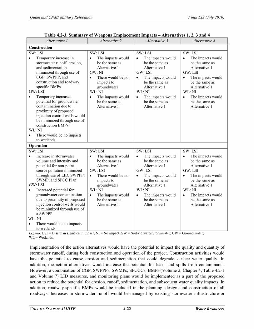
4.2.6 Summary of Impacts
Tables 4.2-1, 4.2-2, and 4.2-3, summarize the potential impacts of each major component – headquarters/housing, munitions storage, and weapons emplacement, respectively. A text summary is provided below.

Guam and CNMI Military Relocation Final EIS (July 2010)
VOLUME 5: ARMY AMDTF 4-20 Water Resources
Table 4.2-1. Summary of Headquarters/Housing Impacts – Alternatives 1, 2, and 3 Alternative 1 Alternative 2 Alternative 3
Construction SW: LSI • Temporary increase in
stormwater runoff, erosion, and sedimentation minimized through use of CGP, SWPPP, and construction and roadway specific BMPs
GW: LSI • Increased potential for NGLA
groundwater contamination NW: LSI • Minor increase in runoff
volume and pollutant loading potential
WL: NI • There would be no impacts to
wetlands
SW: LSI • The impacts would be the same
as Alternative 1 GW: LSI • The impacts would be the same
as Alternative 1 NW: LSI • The impacts would be the same
as Alternative 1 WL: NI • The impacts would be the same
as Alternative 1
SW: LSI • The impacts would be the same
as Alternative 1 GW: LSI • The impacts would be the same
as Alternative 1 NW: LSI • The impacts would be the same
as Alternative 1 WL: SI-M • Direct impact (fill) of 2.4 ac
(1.0 ha) potentially jurisdictional wetland areas
Operation SW: LSI • Increase in stormwater volume
and intensity and potential for non-point source pollution minimized through use of LID, SWPPP, SWMP, and SPCC Plan
GW: LSI • Increased potential for local
groundwater contamination; increase in annual groundwater withdrawal of 0.30 MGd (1.14 mld)
NW: LSI • Minor increase in runoff
volume and pollutant loading potential
WL: NI • There would be no impacts to
wetlands
SW: LSI • The impacts would be the same
as Alternative 1 GW: LSI • The impacts would be the same
as Alternative 1 NW: LSI • The impacts would be the same
as Alternative 1 WL: NI • The impacts would be the same
as Alternative 1
SW: LSI • The impacts would be the same
as for Alternative 1 GW: LSI • The impacts would be the same
as for Alternative 1 NW: LSI • The impacts would be the same
as for Alternative 1 WL: NI • The impacts would be the same
as for Alternative 1
Legend: LSI = Less than significant impact; NI = No impact; SI-M = Significant impact mitigable to less than significant; SW = Surface water/Stormwater; GW = Ground water; NW = Nearshore Water; WL = Wetlands.

Guam and CNMI Military Relocation Final EIS (July 2010)
VOLUME 5: ARMY AMDTF 4-21 Water Resources
Table 4.2-2. Summary of Munitions Storage Impacts – Alternatives 1, 2, and 3 Alternative 1 Alternative 2 Alternative 3
Construction SW: LSI • Temporary increase in
stormwater runoff, erosion, and sedimentation minimized through use of CGP, SWPPP, and construction and roadway specific BMPs
GW: LSI • Increased potential for NGLA
groundwater contamination NW: LSI • Minor increase in runoff
volume and pollutant loading potential
WL: NI • There would be no impacts to
wetlands
SW: LSI • The impacts would be the same
as Alternative 1 GW: LSI • The impacts would be the same
as Alternative 1 NW: LSI • The impacts would be the same
as Alternative 1 WL: NI • The impacts would be the same
as Alternative 1.
SW: LSI • The impacts would be the same
as Alternative 1 GW: LSI • The impacts would be the same
as Alternative 1 NW: LSI • The impacts would be the same
as Alternative 1 WL: NI • The impacts would be the same
as Alternative 2
Operation SW: LSI • Increase in stormwater volume
and intensity and potential for non-point source pollution minimized through use of LID, SWPPP, SWMP, and SPCC Plan
GW: LSI • Increased potential for NGLA
groundwater contamination NW: LSI • Minor increase in runoff
volume and pollutant loading potential
WL: NI • There would be no impacts to
wetlands
SW: LSI • The impacts would be the same
as Alternative 1 GW: LSI • The impacts would be the same
as Alternative 1 NW: LSI • The impacts would be the same
as Alternative 1 WL: NI • The impacts would be the same
as Alternative 1. Additionally there would be no impacts to delineated wetlands
SW: LSI • The impacts would be the same
as Alternative 1 GW: LSI • The impacts would be the same
as Alternative 1 NW: LSI • The impacts would be the same
as Alternative 1 WL: NI • The impacts would be the same
as Alternative 2
Legend: LSI = Less than significant impact; NI = No impact; SW = Surface water/Stormwater; GW = Ground water; NW = Nearshore Water; WL = Wetlands.
Guam and CNMI Military Relocation Final EIS (July 2010)
VOLUME 5: ARMY AMDTF 4-22 Water Resources
Table 4.2-3. Summary of Weapons Emplacement Impacts – Alternatives 1, 2, 3 and 4 Alternative 1 Alternative 2 Alternative 3 Alternative 4
Construction SW: LSI • Temporary increase in
stormwater runoff, erosion, and sedimentation minimized through use of CGP, SWPPP, and construction and roadway specific BMPs
GW: LSI • Temporary increased
potential for groundwater contamination due to proximity of proposed injection control wells would be minimized through use of construction BMPs
WL: NI • There would be no impacts
to wetlands
SW: LSI • The impacts would
be the same as Alternative 1
GW: NI • There would be no
impacts to groundwater
WL: NI • The impacts would
be the same as Alternative 1
SW: LSI • The impacts would
be the same as Alternative 1
GW: LSI • The impacts would
be the same as Alternative 1
WL: NI • The impacts would
be the same as Alternative 1
SW: LSI • The impacts would
be the same as Alternative 1
GW: LSI • The impacts would
be the same as Alternative 1
WL: NI • The impacts would
be the same as Alternative 1
Operation SW: LSI • Increase in stormwater
volume and intensity and potential for non-point source pollution minimized through use of LID, SWPPP, SWMP, and SPCC Plan
GW: LSI • Increased potential for
groundwater contamination due to proximity of proposed injection control wells would be minimized through use of a SWPPP
WL: NI • There would be no impacts
to wetlands
SW: LSI • The impacts would
be the same as Alternative 1
GW: LSI • There would be no
impacts to groundwater
WL: NI • The impacts would
be the same as Alternative 1
SW: LSI • The impacts would
be the same as Alternative 1
GW: LSI • The impacts would
be the same as Alternative 1
WL: NI • The impacts would
be the same as Alternative 1
SW: LSI • The impacts would
be the same as Alternative 1
GW: LSI • The impacts would
be the same as Alternative 1
WL: NI • The impacts would
be the same as Alternative 1
Legend: LSI = Less than significant impact; NI = No impact; SW = Surface water/Stormwater; GW = Ground water; WL = Wetlands.
Implementation of the action alternatives would have the potential to impact the quality and quantity of stormwater runoff, during both construction and operation of the project. Construction activities would have the potential to cause erosion and sedimentation that could degrade surface water quality. In addition, the action alternatives would increase the potential for leaks and spills from contaminants. However, a combination of CGP, SWPPPs, SWMPs, SPCCCs, BMPs (Volume 2, Chapter 4, Table 4.2-1 and Volume 7) LID measures, and monitoring plans would be implemented as a part of the proposed action to reduce the potential for erosion, runoff, sedimentation, and subsequent water quality impacts. In addition, roadway-specific BMPs would be included in the planning, design, and construction of all roadways. Increases in stormwater runoff would be managed by existing stormwater infrastructure or

Guam and CNMI Military Relocation Final EIS (July 2010)
VOLUME 5: ARMY AMDTF 4-23 Water Resources
stormwater infrastructure improvements, stormwater flow paths would continue to mimic area topography; therefore, there would be no increase in flooding risk. No buildings/structures would be constructed in the 100-year flood zone; however, some stormwater detention basins could be constructed in the 100-year flood zone. In some of these areas, these open, grassed stormwater detention basins could also be utilized for additional uses, for example, as recreational fields. While groundwater withdrawal rates would increase, implementation of sustainability practices would reduce the amount of groundwater needed, which would help minimize impacts to groundwater availability. The resulting total annual groundwater withdrawal would be less than the sustainable yield and monitoring of groundwater chemistry would ensure no harm to existing or beneficial use as a result of increased pumping. The action alternatives would be implemented in compliance with all federal, local, and military orders, laws, and regulations (Volume 8, Chapter 3, Table 3.1-1), including Joint Region Marianas Instruction 3500.4 and would include the implementation of BMPs, LID measures, and monitoring.
4.2.7 Summary of Mitigation Measures
Table 4.2-4 summarizes proposed mitigation measures for each action alternative.
Table 4.2-4. Summary of Proposed Mitigation Measures Headquarters/Housing
Alternatives Munitions Storage
Alternatives Weapons Emplacement
Alternatives Construction • Mitigation for
Alternative 3 would compensate for the fill of the 2.4 ac (1.0 ha) potentially jurisdictional wetland areas by creating new wetlands or restoring, enhancing, or preserving existing wetland areas on Guam to, at a minimum, replace the area filled
• None Identified • None Identified
Operation • None Identified • None Identified • None Identified
Volume 7, Chapter 2 describes two additional mitigation measures that could be applied to the proposed action overall: adaptive program management of construction and force flow reduction. Implementing either of these mitigation measures could further reduce impacts to water resources. Adaptive program management of construction (slowing the construction tempo) would decrease the amount of grading and ground disturbance occurring at one time and further reduce the potential for erosion and stormwater runoff. Force flow reduction may minimally reduce the impacts on surface and nearshore water by reducing the wastewater effluent discharged into the ocean.
4.3 LEAST ENVIRONMENTALLY DAMAGING PRACTICABLE ALTERNATIVE
This section focuses on compliance with the Section 404(b)(1) guidelines of the CWA. Specifically, Section 404(b)(1) of the CWA stipulates that no discharge of dredged or fill material into waters of the U.S., which include wetlands, shall be permitted if there is a practicable alternative which would have less

Guam and CNMI Military Relocation Final EIS (July 2010)
VOLUME 5: ARMY AMDTF 4-24 Water Resources
adverse impact on the aquatic ecosystem, so long as the alternative does not have other significant environmental consequences. Furthermore, an alternative is considered practicable if it is available and capable of being implemented after taking into consideration cost, existing technology, and logistics in light of overall project purposes. Section 404 permitting is applicable to the proposed training actions on Tinian. Permitting decisions are based on guidelines (“404(b)(1) Guidelines”) developed jointly with the USEPA that are now part of the Code of Federal Regulations (40 CFR 230). This analysis is to show that the screening and selection process used in the development of this EIS has identified the least environmentally damaging practicable alternative (LEDPA) consistent with the Section 404(b)(1) guidelines.
Since none of the three Munitions Storage Alternatives and four Weapons Emplacement Alternatives involve potential impacts to wetlands as defined in Section 404(b)(1) of the Clean Water Act (CWA), no analysis relative to Section 404 is necessary to identify the LEDPA for these components as defined in the CWA.
The discussion below provides a brief comparative summary of the three Headquarters/Housing Alternatives carried forward for analysis in this EIS and highlights the reasons why Alternatives 1 and 2 are considered the LEDPA. The Navy and the Army have determined that Alternative 1 is the preferred alternative for the proposed action. Alternative 1 is preferred because it is compatible with the Marine Corps preferred alternative, Alternative 2. Requirements for the facilities are addressed in the Marine Corps Main Cantonment component as the Army and Marine Corps would be sharing these facilities. Shared facilities would minimize impact from additional construction. The proposed action includes Administrative/HQ, maintenance operations, and housing facilities for unaccompanied and accompanied personnel.
Sections 2.4-1 of this Volume provide an overview of the background, planning criteria, proposed action elements, and alternatives. The overall purpose of the proposed actions is to relocate and site military forces within the Western Pacific Region based on U.S. policy, international agreements, and treaties.
4.3.1 Alternatives Comparison Summary
4.3.1.1 Alternative 1 (Preferred)
No wetlands are located in or near the construction or operations areas associated with Alternative 1 at NCTS and South Finegayan. Therefore, construction activities and operations associated with Alternative 1 would result in no impacts to wetlands.
Wetlands Differences
4.3.1.2 Alternative 2
No wetlands are located in or near the construction or operations areas associated with Alternative 2 at Navy Barrigada. Therefore, construction activities and operations associated with Alternative 2 would result in no impacts to wetlands.
Wetlands Differences
4.3.1.3 Alternative 3
No wetlands are located in or near the construction or operations areas associated with Alternative 3 at NCTS Finegayan and Navy Barrigada. However, construction activities associated with Alternative 3 at Air Force Barrigada would result in direct impacts to 2.4 ac (1.0 ha) of potentially jurisdictional wetland
Wetlands Differences

Guam and CNMI Military Relocation Final EIS (July 2010)
VOLUME 5: ARMY AMDTF 4-25 Water Resources
areas (Volume 2, Chapter 4, Figure 4.2-5). If the wetland areas identified at Air Force Barrigada are determined jurisdictional by the USACE, and therefore subject to Section 404 requirements, the DoD would first attempt to avoid impacts. If avoidance is not possible, then the DoD would obtain a permit from the USACE to fill the wetlands and comply with mitigation measures outlined in the permit. Therefore, with implementation of the mitigation measures identified in Section 4.2.2.3, construction activities associated with Alternative 3 would result in less than significant impacts to wetlands.
4.3.2 Conclusion
Based on the above discussion, Alternatives 1 and 2 are considered the LEDPA and as previously noted, Alternative 1 is the Marine Corps’ preferred alternative. The environmental differences between Alternatives 1 and 2 are small; however, Alternative 3 would directly impact 2.4 ac (1.0 ha) of potentially jurisdictional wetland areas. Therefore, Alternatives 1 and 2 are the LEDPA.

Guam and CNMI Military Relocation Final EIS (July 2010)
VOLUME 5: ARMY AMDTF 4-26 Water Resources
This Page Intentionally Left Blank.