chapter 6 transport: ships and roads - anu...
TRANSCRIPT
71
¢¢ CHAPTER 6
TRANSPORT: SHIPS AND ROADS
Ships provided the earliest connection between Sydney and South Coast ports. It was a tenuous lifeline, at the mercy of the weather at open places like Bawley Point and Kioloa, but it did not require the large outlay of time or capital needed for roads and bridges.
We have few details of the earliest ships that might have served Murramarang. Presumably many also served ports further south. These are graphically described by Gibbney as ‘a mosquito fleet of sailing craft ranging from cutters of seven or eight tons to barques, brigs and top-sail schooners of seventy or eighty tons’.1 They carried anything they could, including passengers. A passenger who made the trip to Sydney in the 1830s on the cutter Industry recalled:
[The trip] lasted a week with standing room only. The fifteen passengers were only able to sleep in turns. To keep its complement in rations, the ship had to call at every trace of civilisation on the coast and all meals had to be taken ashore to enable passengers and crew to cook the inevitable damper.2
Another glimpse of the poor transport in the early years comes from Mrs Rose, who as a young girl lived at Moruya where her father was overseer for Mr Campbell in the late 1830s:
1 Gibbney, H. J. Eurobodalla: History of the Moruya District, Library of Australian History, Sydney, 1989, p. 40.2 ibid., p. 40.

¢ THEY CAME TO MURRAMARANG
72
There was only one sailing vessel, named Waterwitch or Wonderwitch, that called at Broulee about once a month, bringing provisions from Sydney, and the shortage was at times acute. Aboriginals saved the settlement several times from starvation by supplying fish and oysters.3
Although steamships began to replace sailing ships on the South Coast as early as 1840, there was overlap for many decades.4 I was surprised to find that all the ships referred to in the 1890s as visiting Bawley Point, Kioloa and Durras to load timber were sailing ships. I had known only steamers in the 1920s, but these were relative latecomers, the ones I knew (Bermagui, Narani and Bergalia) starting no earlier than around 1912.5
The shipping service was taken for granted, so only the ships that got into difficulties were mentioned. The Bonnie Dundee was wrecked at Bawley Point on 19 June 1897. The local paper reported the event:
Wreck of the Bonnie Dundee at Bawley Point
Crew Saved: Narrow Escape for Captain
On Thursday night, 17th instant, a heavy chop sea from the north-east was running. The Bonnie Dundee was riding at anchor abreast Mr Guy’s mill. Fears were entertained for her safety, those on board being on watch through the night. At times the sea broke clean over her. At four o’clock on Friday morning, the moorings parted, and in a very short time the unfortunate vessel was on the rocks. With some difficulty a line was got to the shore, and the hands succeeded in reaching the land in safety, with the exception of the Captain, who could not be persuaded to leave her, and Mr Walter Mackay volunteered to go to his rescue. At this time Captain Giddens was not to be seen on the vessel, and young Mackay was none too soon in his rescue. He found the Captain in an exhausted state on the weather side, the Bonnie Dundee being broadside on to the breakers. With some difficulty he got him safe ashore. It is expected the Bonnie Dundee will be a total wreck. Had the sea not moderated she would have broken up quickly. Mr Guy is the owner, and I am given to understand the vessel is insured for 400 pounds.
Later: Since writing the foregoing, the Bonnie Dundee has completely broken up. Portion of her bows is all that remains sticking out of the water.6
They must have been especially unlucky with the weather, as strong north-easters are unusual in winter. From the above account of the wreck, it is not clear where the ship finally broke up. I remember finding some anchor chain
3 Rose, C. A. ‘Recollections of the Early Days of Moruya’, Journal of the Royal Australian Historical Society, 8, 1922–23, p. 375.4 Andrews, G. South Coast Steamers, Marine History Publications, Sydney, undated, p. 9.5 ibid., p. 30.6 Ulladulla and Milton Times, 26 June 1897.

73
6. TRANSPORT: SHIPS AND ROADS
near the seaward end of Cockatoo Rocks, at the south end of Bawley Point Beach, and wondering how it got there. The Bonnie Dundee was built at Macleay River, NSW, in 1876. Dimensions: 84 tons, 85.2 x 19.3 x 7.8 feet.
Earlier (9 February 1895) the Times reported that the schooner Hilda had been blown ashore at Bawley Point, presumably onto the beach, and landed high and dry without any damage. She was still there a week later, but it was hoped she would be re-floated. She was flat-bottomed, so probably a scow rather than a schooner, which made it easier to jack her up so skids could be put underneath. There were no further references, so presumably she was returned to duty. Loney records the loss of a vessel named Hilda at Wreck Bay, 30 July 1908.7 This was probably the same vessel. Details: Built 1891; wooden scow, 65 tons; dimensions 86.2 x 21.8 x 4.4 feet.
Another vessel which visited Bawley Point in the 1890s was the Molinger, mentioned in the local paper on 11 March 1893 in connection with an accident on board: the mate ‘got jammed while stowing a long beam in the hold’.8
The schooner Gleaner — 115 tons, employed in the timber trade — was wrecked at Bawley Point on 20 May 1900. She carried a crew of six and was valued at £900. She was built at Hobart in 1870, and was owned by Mr Guy.9
To complete the list for Bawley Point, Mr Bill Cullen recalled in 1975 that his father had spoken of the wreck of a sailing ship called the Arab. The crew tried to get ashore in one of the ship’s boats which was to be lifted by the crane. It was night, and the lifting did not go as planned; the human load was tipped into the sea. Local mill workers, many of them Aborigines,10 helped fish out the unfortunate crew. Bill Cullen thinks one person might have been drowned. The Cullens lived at Bawley Point for 17 years; this would probably be 1905–1922. Mr Cullen senior was engine driver and fireman at the mill.
There were several wrecks at Kioloa. The schooner Samoa was driven onto Butler’s Point during the night of 6 July 1893 and became a total wreck.11 She was an old craft, formerly used in the slave trade, but had recently been refitted by her owners, Goodlet and Smith, who also owned Kioloa mill at the time. The crew were rescued by lifeline between 5 and 7 a.m., Captain Books
7 Loney, J. K. Australian Shipwrecks: Including vessels wrecked en route to or from Australia, and some strandings, Marine History Publications, 1987, Vol. 4, p. 49.8 ibid., Vol. 3, p. 280.9 Ulladulla and Milton Times, 26 May 1900.10 Aboriginal men were a large part of the timber industry workforce from the early twentieth century, working in the mills and in the forests. They were highly regarded for their skills throughout Victoria, NSW and Queensland. Aboriginal family oral traditions have many references to their men working in the sawmills on the South Coast, crossing many generations. Yet, there is little in the written records. It is a story yet to be written (A.G. and S.F.). 11 Ulladulla and Milton Times, 8 and 15 July 1893.

¢ THEY CAME TO MURRAMARANG
74
being the last to leave the ship. According to Loney, the anchor chain parted in a heavy sea, and the wind was too light to get her under way.12 Details: built Stockholm 1866; wooden vessel of 163 tons; dimensions 112.3 x 25.2 x 11.1 feet.
The Wyoming — a steamer of 258 tons gross and dimensions 132 x 23 x 10.3 feet — was wrecked on the night of 28 October 1910. This wreck was due to engine failure as the ship was about to enter Kioloa between Belowla Island and O’Hara Head. The ship struck the rocks within five minutes, and broke up completely within 24 hours. The crew landed safely on the beach.13 Belle Vider (née Walker) said the captain and crew of the Wyoming stayed with the Walkers after the wreck. The captain gave her father the ship’s barometer, which her brother had for many years.
Neil Evans recalled seeing the steering wheel of the Wee Clyde when he was after lobsters near the Kioloa mill site, but I have no details of the vessel or its wreck. Another source says a vessel called Wee Clyde was built at Narooma in 1909 for the Clyde Sawmilling Company, and burnt at its moorings in 1935.14 In the 1920s, George Moore collected copper sheeting from the old beams of a wreck in this area.
Reg and Innes Collins mentioned the wreck of the trawler Montgomery on Kioloa Mill Point (O’Hara Head), but did not know the date.
Brush Island and Wilford’s Point have claimed a few ships over the years. The earliest appears to have been the barque Camden, which was wrecked between Brush Island and the mainland on 30 January 1870.15 She was en route from London to Sydney with a cargo of 40 tons of pig iron and 2,909 deals, and was a wooden vessel of 235 tons built at Nantes (France) in 1850. Dimensions: 96.3 x 24.4 x 13.5 feet. The crew rowed one of her boats to the Clyde River for assistance; apparently they did not realise Murramarang was settled. Two smaller vessels, the ketch Agnes and Henry (25 tons) and the fore-and-aft schooner Mary Cosgrove (31 tons), were sent to recover some of Camden’s cargo, but went ashore at Murramarang during a gale on the evening of 19 February 1870, and became total wrecks. That summer must have been an open season for ships in the area. A vessel called Bull Pup is believed to have been wrecked near the small beach which now carries that name, but I have not seen any details.
A fishing boat owned by Tony Holt of Ulladulla capsized and sank around two kilometres east of Brush Island in November 1922.16 Holt and his companion, Thomas Brown, a married man with five young children, swam towards the
12 Loney, J. K. op. cit., Vol. 3, p. 229.13 Ulladulla and Milton Times, 5 November 1910.14 Hudson, I. and Henningham, P. Gift of God: Friend of Man, Aust. Forest Ind. Jnl. Pty. Ltd., 1986, p. 84.15 Loney, J. K. op. cit., Vol. 2, p. 220.16 Nowra Leader, 17 November 1922.

75
6. TRANSPORT: SHIPS AND ROADS
island. Holt got ashore, but his companion did not. Holt then had to swim the channel between Brush Island and the mainland — an area with a bad reputation for sharks. He crossed safely, but it is said he gave a bad fright to two men who were panning for gold on Murramarang Beach. They raised their heads to see a naked man appearing out of the surf. They let him have some scanty clothing, and directed him to our house at Bawley Point, where he would be able to phone the police. I remember him coming to the back of the house, and I remember also the consternation with which his news was received.
Two part-Aboriginal brothers, who had been camping on Brush Island for fishing, disappeared in May 1933 and are presumed to have drowned. They were Charles William Thomas Brown, aged 21, and his brother Ezekiel Francis Patrick Brown, aged nine. A half-brother, Syd Lewis Duncan, had been camping on the island with them, but came ashore with fish to sell on 18 May. The Browns rowed back to the island. After some days of bad weather, Duncan returned to the shore opposite the island on 22 May, but did not get any response to his signals. He left, thinking the Browns were fishing on the other side of the island. The next day he returned and signalled again, but with no result. He went to the island with Frank Carriage of Bawley Point in Frank’s boat, but they could not find any trace of the Browns or of their rowing boat. The police were called, but further searches on the island gave no clue. On the beach opposite the island, two oars and parts of the boat were found. No foul play was suspected.
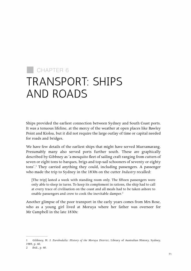
The trawler Athol Star, owned by Les Bringhoff, was wrecked at Bull Pup Beach (east end) around 1950. The hull lay in the sand there for perhaps 20 years, an object of passing interest, especially to children.
The largest vessel wrecked in the area was the Northern Firth. She struck an uncharted reef near Brush Island on the afternoon of Sunday 21 February 1932. Water entered the engine room, disabling the engines. A strong north-east wind drove her onto the north-east corner of Brush Island, where she stuck fast and in the next few weeks became a total wreck. She had been carrying around 1,800 tons of general merchandise from Melbourne. Some of this drifted away from the ship and was washed ashore mainly to the south. Some, including spirits, was pillaged before a guard could be placed on the wreck. Due to the Depression, there was more than usual interest in scavenging and beachcombing. The Northern Firth was built in 1922 by Grangemouth Dockyard Co.: 1,954 tons gross; 1,163 tons net; dimensions 280.2 x 41.9 x 19 feet.17 She was under charter to James Patrick and Co., Sydney.
17 Loney, J. K. op. cit., Vol 4, p. 140.
¢ THEY CAME TO MURRAMARANG
76
Figure 26: Athol Star wrecked on Bull Pup Beach, c. 1950.Source: A . R . Settree, Huskisson, NSW .
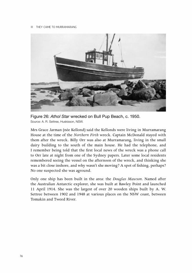
Mrs Grace Jarman (née Kellond) said the Kellonds were living in Murramarang House at the time of the Northern Firth wreck. Captain McDonald stayed with them after the wreck. Billy Orr was also at Murramarang, living in the small dairy building to the south of the main house. He had the telephone, and I remember being told that the first local news of the wreck was a phone call to Orr late at night from one of the Sydney papers. Later some local residents remembered seeing the vessel on the afternoon of the wreck, and thinking she was a bit close inshore, and why wasn’t she moving? A spot of fishing, perhaps? No one suspected she was aground.
Only one ship has been built in the area: the Douglas Mawson. Named after the Australian Antarctic explorer, she was built at Bawley Point and launched 11 April 1914. She was the largest of over 20 wooden ships built by A. W. Settree between 1902 and 1948 at various places on the NSW coast, between Tomakin and Tweed River.

77
6. TRANSPORT: SHIPS AND ROADS
Figure 27: Northern Firth wrecked on Brush Island, February 1932.Source: The Edith and Joy London Foundation of The Australian National University .
These days we think of ships being built in well-equipped shipyards, so the building of a single ship in an isolated settlement is hard to understand. Why was it done that way? There were several reasons. It was built for A. & E. Ellis, timber merchants, who probably already owned the Bawley Point mill (see Chapter 4). It was easier in those days for the shipwrights, around eight in number, to go with their simple hand tools to a site near a mill, than to have timber cut and transported to a shipyard. The special hardware needed had to come from Sydney; this was easier by ship than by road. And it was very important for the shipwrights to have their say in the selection of timber in the forest, since so many pieces of special shape were required. The ship was built in the open, so no special large building was needed. Some official details of the vessel, from Lloyds Register (1918) and supplied by Ronald Parsons, South Australia, are:
Wooden twin screw steamship, official number 136387, ketch rigged, i.e. two masts, one deck, 333 gross and 167 nett-tons. 141.6 x 30.7 x 7.8 [these would be length, breadth and draught, in feet]. Two compound steam engines by Chapman and Co., Sydney.
Good descriptions of the building methods current at the time are given in two recent books.18 These books contain accounts of interviews with Alf Settree of Huskisson, NSW, son of the builder of Douglas Mawson. Here we give only a very brief outline of the tools and methods.
18 Kerr, G. The Tasmanian Trading Ketch: An Illustrated Oral History, Mains’l Books, Portland, 1987, pp. 37–8, 54–67; Kerr, G. Craft and Craftsmen of Australian Fishing 1870–1970: An Illustrated Oral History, Mains’l Books, Portland, 1985, p. 138. See also the Lady Denman Maritime Museum in Huskisson.
¢ THEY CAME TO MURRAMARANG
78
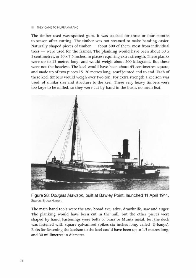
The timber used was spotted gum. It was stacked for three or four months to season after cutting. The timber was not steamed to make bending easier. Naturally shaped pieces of timber — about 500 of them, most from individual trees — were used for the frames. The planking would have been about 30 x 5 centimetres, or 30 x 7.5 inches, in places requiring extra strength. These planks were up to 15 metres long, and would weigh about 200 kilograms. But these were not the heaviest. The keel would have been about 45 centimetres square, and made up of two pieces 15–20 metres long, scarf jointed end to end. Each of these keel timbers would weigh over two ton. For extra strength a keelson was used, of similar size and structure to the keel. These very heavy timbers were too large to be milled, so they were cut by hand in the bush, no mean feat.
Figure 28: Douglas Mawson, built at Bawley Point, launched 11 April 1914.Source: Bruce Hamon .
The main hand tools were the axe, broad axe, adze, drawknife, saw and auger. The planking would have been cut in the mill, but the other pieces were shaped by hand. Fastenings were bolts of brass or Muntz metal, but the deck was fastened with square galvanised spikes six inches long, called ‘U-bangs’. Bolts for fastening the keelson to the keel could have been up to 1.5 metres long, and 30 millimetres in diameter.
79
6. TRANSPORT: SHIPS AND ROADS
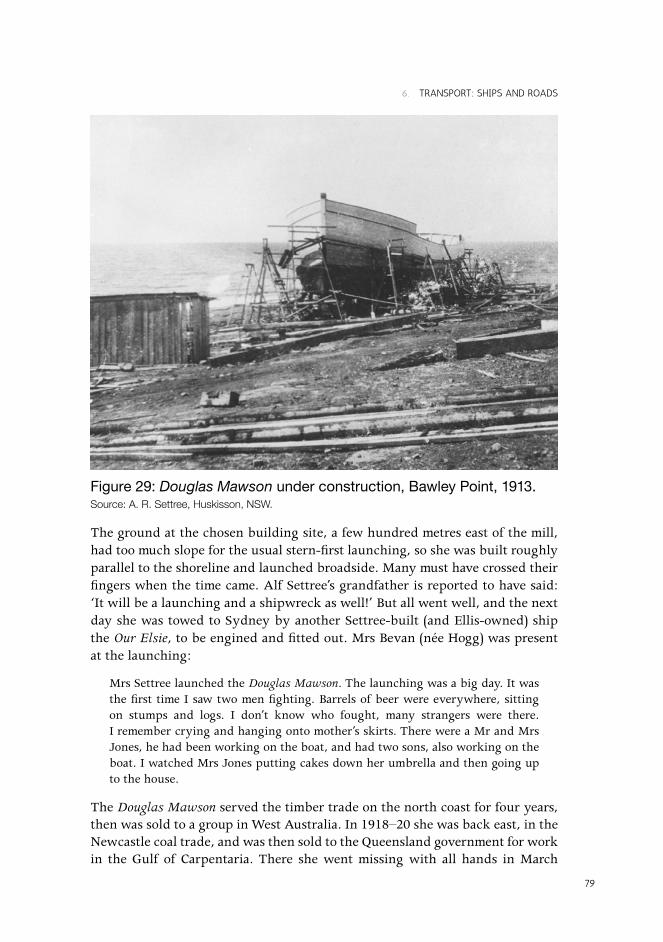
Figure 29: Douglas Mawson under construction, Bawley Point, 1913.Source: A . R . Settree, Huskisson, NSW .
The ground at the chosen building site, a few hundred metres east of the mill, had too much slope for the usual stern-first launching, so she was built roughly parallel to the shoreline and launched broadside. Many must have crossed their fingers when the time came. Alf Settree’s grandfather is reported to have said: ‘It will be a launching and a shipwreck as well!’ But all went well, and the next day she was towed to Sydney by another Settree-built (and Ellis-owned) ship the Our Elsie, to be engined and fitted out. Mrs Bevan (née Hogg) was present at the launching:
Mrs Settree launched the Douglas Mawson. The launching was a big day. It was the first time I saw two men fighting. Barrels of beer were everywhere, sitting on stumps and logs. I don’t know who fought, many strangers were there. I remember crying and hanging onto mother’s skirts. There were a Mr and Mrs Jones, he had been working on the boat, and had two sons, also working on the boat. I watched Mrs Jones putting cakes down her umbrella and then going up to the house.
The Douglas Mawson served the timber trade on the north coast for four years, then was sold to a group in West Australia. In 1918–20 she was back east, in the Newcastle coal trade, and was then sold to the Queensland government for work in the Gulf of Carpentaria. There she went missing with all hands in March

¢ THEY CAME TO MURRAMARANG
80
1923, a victim of one of the worst cyclones known in the area. Meteorologists still refer to the ‘Douglas Mawson cyclone’, so at least the name carries on, though the circumstances might have been happier.
The ships I remember at Bawley Point in the 1920s were all steamers, owned and operated by the Illawarra and South Coast Steam Navigation Co. Ltd. (usually referred to as the ISN Co.). The same ships also called at Kioloa. The ISN Company operated from 1904 to 1951.19 Their fleet was referred to as the ‘Pig and Whistle Boats’, as they often carried pigs (and calves) in temporary pens on deck. The pens were just forward of the passengers’ accommodation, so a slight headwind made life unpleasant for any passengers. The Bermagui (steel), Bergalia (steel) and Narani (wood) were all about 150 feet long, so they were roughly the same size as the Douglas Mawson. These three are the ones I remember most, as they continued calling at Bawley Point for timber for some years after the mill burnt down in 1922. The Benandra (wood) and Bodalla (wood), both wrecked in 1924, probably called also in earlier years.
The arrival of a ship was a great event. The ship’s whistle was blown as she rounded the point, so men could be available to help make mooring lines fast to ring bolts set in the rocks. (An old chap at Kioloa decided to make his first trip to Sydney by ship. He was asked if he had anyone to meet him. ‘No’, he said, ‘but they’ll hear her blow!’)
Three names of captains I can recall are Andrews, Jackson and Miles. We were especially friendly with Captain ‘Billy’ Andrews. He did shopping for us in Sydney, came ashore to visit while the ship was loading, and (I was told later) took me for walks when I was too young to venture out alone. We kept in touch with him in later years. He was a short man who spoke with a nasal twang caused by a broken nose early in life. He told me of strong ocean currents, especially near Jervis Bay, which could set either onshore or offshore. This seemed unlikely, but I found later that he was right: large anticlockwise eddies, when close to the coast, would account for such currents.
Large tins of dripping, from the ship’s galley, were often brought ashore and shared by several families. I think we supplied fresh milk in return, but I cannot remember how it was transported; the usual open bucket seems an unlikely choice. The captains came ashore in a small dinghy, propelling it with a single oar at the stern. At Kioloa, the Moore family sold young wild parrots to the ship’s crew, who resold them in Sydney. The crew provided ropes for climbing to the nests.
19 Australasian Shipping Record, May 1974.

81
6. TRANSPORT: SHIPS AND ROADS
With improved land transport, the ISN ships rarely carried passengers. My mother and I went from Bawley Point to Ulladulla once, on our way to Sydney, and Belle Vider made one trip from Kioloa to Sydney. I think the Bermagui was the only ship with any passenger accommodation.
What happened the Pig and Whistle Boats? Bermagui was one of only two ships still operated by the ISN Co. when it went out of business in 1952. At that time, she was handling timber from a restricted range of ports.20 She was a mine sweeper during World War II. In 1955 she finally left Sydney, becoming a gravel barge on the Brisbane River, and later a gravel dredge. Bergalia ended up in Noumea where she was converted to a powered lighter, and was reported still in service under the name Tiburon III in 1974. Bergalia was the youngest of the three regular callers at Bawley Point, having been built following the loss of Benandra in 1924. Narani was also used as a mine sweeper during the war. In 1950 she went to New Guinea, where she was probably broken up around 1955.
Bergalia performed an unplanned but very welcome service in the district in her later years. She was tied up at the Ulladulla wharf when severe bush fires broke out in the district on 14 January 1939. Water was not laid on at the time, and things could have been much worse than they were if the ship’s crew had not started the pumps and filled 44 gallon drums with sea water. The filled drums were taken by lorry to the fire fronts.
The history of roads in any area is hard to trace. They start as mere tracks, and are abandoned quickly and without record when a new route opens. Only the most successful and important are surveyed. Roads have been mentioned in earlier chapters, but here we try to summarise what little is known.
The earliest road in our area was almost certainly the road from Murramarang to Ulladulla, said to have been finished before 1837 (see Chapter 2). Although no route details were given in the one line statement that the road had been made, I believe this road was the one referred to in my school days as ‘the old South Coast coach road’, and which I could trace from north of Meroo Lake to at least Murramarang. It crossed the mouths of Willinga and Meroo lakes, and would have crossed Termeil, Tabourie and Burrill lakes in similar fashion. At the Willinga Lake crossing, stonework and fill were needed to grade the track up from the beach to Willinga headland. This stonework forms the base of the present rough foot track, and traces of the original stone wall can still be seen on the left side of the track going down. This wall was much more clearly visible in the 1920s. Although the track itself was also fairly obvious at that time, it was clear it had not been used for a long time, probably many decades.
20 ibid., May 1974, p. 139.

¢ THEY CAME TO MURRAMARANG
82
I doubt if this was ever a ‘coach road’, in the sense of a route for regular passenger coaches. It would have been put in for use by bullock drays or wagons, which could negotiate the stretches of beach sand without too much difficulty. It is likely the early settlers did not realise the lakes opened to the sea and could stay open for long periods. The sand banks, quicksand and tidal currents when the lakes were open must have presented many extra difficulties. It is not clear why the road was not routed around the heads of at least Willinga, Meroo and Termeil lakes, which are smaller than the other two. I suspect the route was chosen without much thought, and almost certainly without a proper survey.
This is almost certainly the track that the Rees Jones family would have taken on their way to and from Brooman through Murramarang in the 1840s (see Chapter 2). It is interesting that their route from Boro was via Nerriga, across towards Jervis Bay and south to Ulladulla, Murramarang and Brooman. There was no direct vehicle route from Braidwood to the coast at that time. Mrs Jones mentions that they travelled along the sea beaches, taking advantage of the firmer sand near the water. This was done both north and south of Ulladulla, and under very trying conditions in hot weather. At one stage on their way north, and probably on Tabourie Beach, they were ‘desperately hungry and faint … but on, on we went, hour after hour, mile after mile, still keeping along the beach’. They were very grateful to find a lot of fish stranded in a water hole; some of these were taken with them to ‘Garrett’s farm’, where they stayed the night. This is believed to be the farm of the Garrad family near Milton, Garrad having been Stephen’s first overseer at Murramarang. The Garrads were grateful for the fish, as they were nearly out of food, and were reduced to eating parrots.
Figure 30: Old coach road, 1988.Source: Margaret Hamon .

83
6. TRANSPORT: SHIPS AND ROADS
The next mention of the road is by a correspondent for Town and Country Journal in 1870. He was on horseback, but referred to ‘the dray track on the margin of the Meroo’ (see Chapter 3). ‘Dray track’ seems a more appropriate name than ‘coach road’. The purpose of this road was so that the better harbour facilities at Ulladulla could be used, but it was apparently not fully successful, as some Murramarang produce was still being shipped from Kioloa in 1843 (see Chapter 2).
A direct road from Murramarang to Brooman, marked ‘R1119a R’, is shown on maps of Termeil and Albert parishes, but I have been unable to find any details or date. Most likely it was the route used by the Rees Jones family in the 1840s. I do not remember any mention of this road in the 1920s. The route shown on the parish maps is remarkably direct and smooth.
A surveyed road marked ‘from Batemans Bay’ and ‘to Murramarang’ appears on early survey maps of land portions on Durras Mountain (see Chapter 3). The route was up the north-east ridge and slightly west of the top of the mountain. I have seen no direct reference to the use of this road; it might have been the route used by the mailman mentioned by the Town and Country Journal’s reporter in 1870 (see Chapter 3), but this service was probably on horseback rather than by vehicle. There was no way for vehicles to cross the Clyde at Batemans Bay until the first punt in 1871; the power ferry did not start till 1915, and the bridge dates from 1956. The ferry at Nelligen started in 1875.
Figure 31: Collins’ household goods being moved from Taralga to Willinga, 1919.Source: The Edith and Joy London Foundation of The Australian National University .

¢ THEY CAME TO MURRAMARANG
84
After Termeil was settled, its link to Milton was via Monkey Mountain Road and Woodburn Road, as this route did not require any large bridges. It was often called ‘the top road’. The route along the present Princes Highway developed in the 1890s and later. The well-built early road from near Flat Rock along the ridge west of Termeil, and marked ‘old coach road’ on the Tabourie 1:25,000 topographic map, would have avoided crossing even Termeil Creek (at the foot of Monkey Mountain), and may have been an alternative route into Termeil. At Flat Rock, a road branched to the south-west to Brooman and Shallow Crossing. This was presumably the preferred route to Batemans Bay and Moruya before ferry services started at Nelligen and Batemans Bay. Shallow Crossing’s submerged concrete causeway was not put in until around 1930.21
Princes Highway was officially named in 1920, but at least parts were in use much earlier. It took a long time to earn the title of ‘highway’. Belle Vider (née Walker) said their family bought a T-model Ford as their first car, and ‘thought they were toffs’. They set out for a holiday at Blackheath, but between Milton and Nowra ‘I don’t think we travelled the main road once. We were going through the bush on side tracks.’
Nearer home, ‘Smart’s Road’ has already been mentioned (see Chapter 5). This would have linked Durras Mountain (where Smart took up land around 1870), and possibly Kioloa, to Termeil. It appears to have been more inland than the present Kioloa–Bawley Point–Termeil road, and so would have avoided crossing Willinga Lake.
The tramline bridge was the earliest bridge over Willinga Lake, but it was unsuitable for vehicles, though one car did cross it in the early guest house days. From the start of Bawley Point mill until around 1932, vehicles coming from Termeil to Bawley Point crossed the lake near the site of the present bridge, or detoured from ‘The Boiler’ around the head of Willinga Lake to Murramarang. This detour was due to Mr Walker, so must have been put in after 1910. The lake bottom was firm enough, but you had to know and stick to an ill-defined J-shaped route where the water was shallow. Car drivers were advised to get out and walk through the lake first to check route and depth — no one thought to put up a depth indicator. Many cars stalled due to water in the engine, and had to be pulled out by bullocks or horses. This crossing was impassable after heavy rain, until the lake opened to the sea either naturally or with the help of many men with shovels.
21 The Shoalhaven Telegraph, Nowra, 14 August 1929.

85
6. TRANSPORT: SHIPS AND ROADS
Figure 32: Wooden bridge over Willinga Lake, c. 1960.Source: Courtesy of the Dummett family .
The lake crossing affected horse-drawn vehicles as well as cars. Belle Vider recalled my father and grandfather (Henry Reynolds) trying to cross in a sulky to pick up supplies of bread and meat when the delivery truck could not get through. The horse jibbed in the middle of the lake, broke itself free and started off upstream. My father had no option but to go after the horse, up to his neck in water, much to the amusement of grandfather Reynolds. My father ‘was that mad he felt like getting the shafts and tipping Mr Reynolds and the lot into the lake!’ Even horse riders could have trouble. My pony often jibbed at crossing the lake, but I must admit he was spoilt and needed little excuse to put one over me.
A vehicle bridge was built eventually, around 1932. It was a simple structure: logs laid on the bed of the lake parallel to the shore, stringers across these, and decking on the stringers. It was built by Jack Bevan and Frank Evans. My grandmother nicknamed the builders ‘Daudlin’ Along’: a skit on ‘Dorman and Long’ who were building the Sydney Harbour Bridge at the time.
This first bridge was replaced or at least extensively repaired in 1943. Neil Evans worked on this, with help from one of the council’s road maintenance staff. The present concrete bridge was opened on 16 April 1969.
¢ THEY CAME TO MURRAMARANG
86
Although the lake crossing was difficult, the Termeil–Bawley Point road itself was no more than a track for many years. In April 1893, the local Times reported: ‘The road from Termeil to Wallinga is in a frightful state. On Monday last a gentleman’s buggy got stuck in the mud, and a team of bullocks had to be got to extricate it.’
At Kioloa, roads were made and improved by the London family after 1929. Their first major effort was a road up the ‘Dangerboard’, along the track of the tramline from the mill. They first took up the disused tracks, using some as flooring joists when extending their house. They used existing bullock tracks where possible, and eventually extended the road west to Princes Highway, giving the district another alternative to the crossing of Willinga Lake. Later, a shorter route, now marked on the Kioloa map as ‘Moore’s Road’, was made through the back of their property.
The early routes from Bawley Point to Kioloa crossed private property, and this meant gates or slip rails had to be opened and shut, and suitably cursed, by all travellers. There were even a few of the fiendish ‘Queensland Gates’ in the area; these were barbed wire fastened to a gatepost at one end and to a loose pole at the other; the pole sat in a wire loop around the other gatepost at the bottom, and was fastened at the top by a moving loop. It sounds simple, and of course it is simple, but perhaps we should leave the rest unsaid. Some gates remained for many years, being removed only after the road was properly surveyed and its land resumed.
Around this time (the 1920s and 1930s), the Forestry Department built many roads in State Forests.
According to Clark, the first regular coach service between Nowra and Bega began in 1893.22 Run by R. T. Thorburn, it was quite a large undertaking, with 40 coaches and 150 horses. By this date, there were bridges over Tabourie and Burrill lakes. Lucy King gives a slightly earlier starting date (1890), at least for a service between Nowra and Moruya run by Barney McTiernan.23
22 Clark, A. (ed.) Shoalhaven Dateline, Shoalhaven Historical Society, Nowra, 1988, p. 11.23 King, L. The Timber Industry in the Southern Portion of the Shoalhaven Shire, unpublished MS, Milton/Ulladulla Historical Society, No. M634.
This text is taken from They Came to Murramarang: A History of Murramarang, Kioloa and Bawley Point, by Bruce Hamon,
edited by Alastair Greig and Sue Feary, published 2015 by ANU Press, The Australian National University, Canberra, Australia.