chapter 7: aquatic areas - king county, … processes that form and sustain aquatic areas and...
TRANSCRIPT

Chapter 7:
AQUATIC AREAS 7.1 INTRODUCTION ..................................................................................................................1 7.2 REVIEW OF LITERATURE .................................................................................................2
7.2.1 Processes that Form and Sustain Aquatic Areas and Species ..........................................2 The Role of Water....................................................................................................................2 The Role of Glaciers ................................................................................................................3 The Role of Forests..................................................................................................................3 The Role of Animals................................................................................................................4
7.2.2 Natural Cycles of Change and the Role of Disturbance...................................................5 Channel Migration and Shoreline Erosion...............................................................................5
7.2.3 The Diversity of King County’s Aquatic Life .................................................................6 Salmonids as Ecological Indicators and Keystone Species .....................................................6 Other Species as Indicators of Ecological Health and Change................................................8
7.2.4 Examples of Integrated Ecological Models: The River Continuum Concept and Marine Intertidal Zonation............................................................................................................9
7.2.5 Effects of Land Development on Aquatic Habitats and Species....................................13 7.2.6 Processes Conclusion .....................................................................................................14 7.2.7 Strategies for Protection.................................................................................................15 7.2.8 Approaches to Aquatic Area Protection.........................................................................16
Riparian Areas .......................................................................................................................17 Protecting Landscape Scale Functions...................................................................................26
7.2.9 Strategies for Protection Conclusion..............................................................................27 7.3 LITERATURE REFERENCES............................................................................................28

EXECUTIVE REPORT – BEST AVAILABLE SCIENCE, VOLUME 1 – FEBRUARY 2004
Chapter 7 – Aquatic Areas
7 – 1
Chapter 7: AQUATIC AREAS
7.1 INTRODUCTION
Fish and Wildlife Habitat Conservation Areas (FWHCAs) are one of the five Growth Management Act defined critical areas (RCW 36.70A.030(5)). Fish and Wildlife habitat conservation means land management for maintaining species in suitable habitats within their natural geographic distribution so that isolated subpopulations are not created; it does not mean maintaining all individuals at all times (WAC 365-190-080(5)). The State of Washington has established guidelines regarding FWHCAs (WAC 365-190-080(5)(a)) and after considering these guidelines, King County has promulgated Comprehensive Plan policies regarding FWHCAs. King County has designated certain areas as FWHCAs and protects these FWHCA through the use of regulations such as the proposed CAO, incentives, capital projects, and purchase. Aquatic areas are the habitat for the aquatic species and habitats designated as FWHCAs in King County’s Comprehensive plan and include the following aquatic habitats and species:
Habitat for federal or state listed endangered, threatened or sensitive species; Habitat (including juvenile feeding and migration corridors in marine waters) for Salmonids
of Local Importance including: - Chinook/king salmon
- kokanee/sockeye/red salmon,
- chum salmon,
- coho/silver salmon,
- pink salmon,
- coastal resident/searun cutthroat,
- rainbow trout/steelhead,
- bull trout,
- Dolly Varden, and
- pygmy whitefish;
Commercial and recreational shellfish areas; Kelp and eelgrass beds; Herring, sand lance and smelt spawning areas; and Riparian corridors.

EXECUTIVE REPORT – BEST AVAILABLE SCIENCE, VOLUME 1 – FEBRUARY 2004
Chapter 7 – Aquatic Areas
7 – 2
7.2 REVIEW OF LITERATURE
The most basic functions of an aquatic area are the storage, purification, or transport of water. In so doing, they also function as habitat for a large number of plants and animals. Specific types of aquatic habitats in King County include rivers, streams, lakes, ponds, wetlands1, estuaries, marine nearshore areas, and shallow aquifers. These habitats and the species that use them are integrated parts of an aquatic ecosystem that has developed, and continues to develop, due to a myriad of climatic, geologic, and plant and animal interactions. Human development of land and water often affects this ecosystem in profound ways, ultimately affecting the type and abundance of species that exist.
This review focuses primarily on the formation and habitat functions of aquatic and riparian areas, factors that influence those functions and how King County is proposing to protect them. Much of this discussion focuses on salmonids and their habitats in part because of their ecosystem, social, and commercial importance. But also because more is known about them than any group of animals and their near-ubiquitous distribution and sensitivity to environmental change makes them good indicators of habitat impacts and of the effectiveness of protection measures for aquatic systems and other aquatic species.
Despite this report’s focus on habitats and species, it is important to note that aquatic areas and their ecosystems include people and provide many other socially valuable benefits including flood hazard reduction, conveyance of stormwater runoff, water supply, water quality purification, recreation, and navigation. Increasingly it is being recognized that the management of ecosystems for both their natural resources and social values results in systems that are more productive and less expensive to maintain over time.
7.2.1 Processes that Form and Sustain Aquatic Areas and Species
Understanding how aquatic habitats and species are formed and sustained is essential in devising a strategy for their protection. The following describes the physical and biological processes that are critical in this understanding.
The Role of Water
Water-generated energy and the chemical properties of water set the stage for the formation and function of aquatic areas. Movements of water whether as slow-moving glaciers, flowing streams, tides or waves generate the energy necessary to scour, transport and deposit sediments (Richards 1982; Downing 1983). In addition, the chemical properties of water allow for the dissolution, suspension, or absorption of many materials--including fine sediments, nutrients and chemical compounds--further adding to water’s habitat forming capabilities (Hynes 1972).
1 The proposed King County Critical Areas Ordinance discusses and defines wetlands separately from other aquatic areas, since wetlands are regulated under different statutes and legal mandates.

EXECUTIVE REPORT – BEST AVAILABLE SCIENCE, VOLUME 1 – FEBRUARY 2004
Chapter 7 – Aquatic Areas
7 – 3
Acting together, these properties of water shape or set the template for many of the processes that form and determine the productivity of aquatic habitats.
The Role of Glaciers
Glaciers set the stage for today’s habitats (Booth et al. 2002). They blanketed much of Puget Sound’s landscape as recently (in geologic time) as ten to fifteen thousand years ago and, as they receded from the lowlands, created the initial shape of the landscape seen today. (King County 1987; Downing 1983; Booth 1987).
The unstable bluffs along much of Puget Sound and the region’s river valley hillsides, steep ravines, shifting shorelines and meandering river channels are a direct result of the actions of glaciers. These features and the dynamic erosional processes they encompass, while dangerous to improperly sited human structures (Gerstel et al. 1997; Palmer et al. 1998), are the source of sediments which, when delivered at natural rates and magnitudes, replenish and rejuvenate aquatic habitats.
Glaciers also left an array of less dynamic but equally important features, including extensive till and outwash-based plains, containing springs, lakes, ponds, bogs, and fens. Some of these features, such as springs and especially bogs and fens, are uniquely adapted to the highly stable post-glacial conditions in which they formed. As a result they are highly susceptible to subtle changes in the rate and magnitude of water and sediment delivery caused by improperly controlled land development (Kulzer et al. 2000).
Glaciers also greatly influenced soils (Gerstel et al. 1997). In some cases, receding glaciers left highly compressed surface soils, called till, with relatively low water permeability (although usually far more permeable than paved surfaces). In other cases, glaciers left well-washed, highly permeable gravel and coarse sand deposits called outwash. The type of soils within its catchment heavily influences the hydrology of aquatic areas. Streams draining areas with high levels of till will have faster runoff and flashier flows than those dominated by glacial outwash.
The Role of Forests
Following glaciation, land was stabilized and hydrology moderated by coniferous-based forests that became established in coastal areas of the Pacific Northwest. These forests were comprised of some of the largest trees and highest vegetation biomass of any ecosystem on earth (Franklin 1988). Where those forests remain intact, their canopy, understory, accumulated organic matter and surface soils intercept and store the vast majority of storm precipitation and subsequently meter it out gradually to aquatic habitats and underlying aquifers. The type and amount of vegetation, both riparian and upland, tempers the erosive energy of water as well as the rate of sediment scour and transport (Gordon et al. 1992).
In addition to its hydrologic influence, forest vegetation serves as a source of nutrients upon which other plants and animals thrive, is important in water, sediment and nutrient storage and cycling, and helps create structurally and functionally diverse aquatic habitat.

EXECUTIVE REPORT – BEST AVAILABLE SCIENCE, VOLUME 1 – FEBRUARY 2004
Chapter 7 – Aquatic Areas
7 – 4
Dead and down woody vegetation (woody debris) of all species, shapes and sizes accumulates, sometimes in huge quantities, on the forest floor as well as in streambeds and estuaries and along lake and marine shorelines. Prior to modern development, large amounts of large woody debris extensively littered marine shorelines, estuaries, and rivers (see Maser et al. 1988; Bilby and Bisson 1998; Collins and Montgomery 2002; Collins et al. 2002). In some cases, the size and volume of the woody debris was sufficient to create logjams that spanned rivers as large as the Skagit (Sedell et al. 1988).
Large and small woody debris interacts with water and sediment to create localized sediment scouring and deposition, and results in more complex, and in many cases, more stable habitat than would occur in the absence of such material (Sedell and Beschta 1991; White 1991; Montgomery and Buffington 1998; Heede 1985; Jackson and Sturm 2002; Ralph et al. 1994; Beechie and Sibley 1997; Ulrike and Peter 2002). In streams, woody debris generated pools and riffles provide habitats for migration, spawning, rearing, and refuge from periodic disturbances, such as major storms or landslides. In marine nearshore environments, woody debris diffuses the energy of tides and waves, thereby modifying on-shore sediment transport and helping to create habitats ranging from muddy bays to gravel or bedrock beaches. In all aquatic environments, including lakes, ponds and estuaries where water energy is very low, woody debris increases the amount, diversity, and quality of cover needed for resting, foraging, and predator avoidance.
The Role of Animals
In addition to water, glaciers, and forests, aquatic animals themselves can play a major role in the structure and functioning of their habitats and ecosystems. Beavers (Castor canadensis) and Pacific salmon (Oncorhynchus spp) are perhaps the best examples of aquatic animals that modify their own environments, often with profound, far-ranging effects. Beavers, which were once much more abundant than they are today, dam extensive segments of small stream channels and riverine valley floors altering flow and sediment deposition patterns and creating considerable habitat for plant and animal species such as willow (Salix spp) and coho salmon (Oncorhynchus kisutch), respectively (Naiman et al. 1992; Beechie et al. 1994; Murphy et al. 1989; Snodgrass and Meffe 1998; Collen and Gibson 2000). Pollock et al. (2003) found documentation of use of beaver ponds as habitat by more than 80 species of fish, 48 of which commonly used them. Beaver ponds create highly productive slow water with high-vegetated edge-to-surface ratios and extensive cover. As a result they typically harbor more and larger fish than unponded areas (Gard 1961; Hanson and Campbell 1963; Murphy et al. 1989; Leidholt Bruner et al. 1992; Schlosser 1995). In addition to fish, beaver ponds have been shown to be productive habitats for many birds, mammals, plants, and insect (Naiman et al. 1988; Pollock et al. 1994).
Salmon, especially when returning in large numbers, can reshape substantial areas of stream and, in some cases, near-shore substrates by loosening gravels during excavation of their nests, and in the process improving spawning substrates by releasing fine sediments and organic matter which could interfere with continuous oxygenation of their embryos (National Research Council 1995; Quinn and Peterson 1994). They also deposit large amounts of marine-derived nutrients that boost aquatic food chain productivity and survival of their juveniles as well as nourishing many other plants and aquatic and terrestrial animals (National Research Council 1995; Cederholm et al. 1989; Cederholm et al. 1999; Gende et al. 2002). Given the role of these and many other species in the functioning of aquatic habitats, it is necessary to protect fish and wildlife species

EXECUTIVE REPORT – BEST AVAILABLE SCIENCE, VOLUME 1 – FEBRUARY 2004
Chapter 7 – Aquatic Areas
7 – 5
directly, in addition to protecting the physical and vegetative components of these critical areas in order to achieve full and comprehensive protection of aquatic areas.
7.2.2 Natural Cycles of Change and the Role of Disturbance
As described above, the type, amount, and condition of aquatic habitats reflect a complex, dynamic interplay of water, soil, plants, and animals. This interplay is not static (Independent Multidisciplinary Science Team 2002). Rather it occurs in cycles of intensity driven by global, regional and local climatic (temperature and rainfall) and geologic processes (earthquakes, volcanoes, soil formation, and transport processes) (National Research Council 1995). While the cycles may be gradual and subtle, the effect is sometimes dramatic, in the form of floods, fires, and droughts and, at much longer intervals, volcanoes, and ice ages. These periodic events are referred to as “disturbances.” Often viewed as disasters when people, homes, or property are affected, they are important for the functioning of an ecosystem and for the persistence of many species (Reice et al. 1990; Reice 2001). The frequency and magnitude of these events over time define a region’s disturbance regime. It is to those regimes that the native species are adapted.
Regardless of how or why they occur, such environmental perturbations have favored the evolutionary survival of plants and animals with life history strategies that enable them to cope with and to some extent thrive on disturbance (Reeves et al. 1995; Independent Multidisciplinary Science Team 2002). Natural disturbances periodically reshape and rejuvenate the landscape and its habitats. For example, regional climatic cycles of warming or drying may culminate in intense and widespread fires (Agee 1997), which in turn are important for the propagation of certain plants and animals. Conversely, periods of increased moisture may lead to greater frequency and intensity of storms resulting in greater flooding and erosion (Swanson et al.1982; Independent Multidisciplinary Science Team 2002) that in turn can lead to improved spawning and rearing habitat and riparian vegetation for fish.
Channel Migration and Shoreline Erosion
Stream channel migration and shoreline erosion are key erosional processes that are critical for creating and sustaining healthy, diverse habitats. In large part, they are ecological processes driven by disturbance regimes, such as floods and cycles of freezing and thawing which periodically deliver large volumes of water, sediment, and large woody debris. They contribute fine sediments, spawning gravel, woody debris and nutrients that sustain and invigorate existing habitats, create new habitats, such as side channels and oxbow ponds, where none previously existed, or fill in old, less productive habitats. In less dramatic ways, these processes also result in lateral scouring along banks and shorelines creating pools and riffles in stream channels and diverse habitats along marine, estuarine and lake shorelines (White 1991)
Recognition of the role these processes play and the hazards they represent to people have resulted in the designation of channel migration zones (CMZs) along rivers and protective setbacks along eroding bluffs and beaches of Puget Sound (see Section on Flood Control and Channel Migration Zones). But much historic development has occurred in these areas and to some degree is still occurring. As a result, habitat-forming processes have been greatly reduced

EXECUTIVE REPORT – BEST AVAILABLE SCIENCE, VOLUME 1 – FEBRUARY 2004
Chapter 7 – Aquatic Areas
7 – 6
or lost along many of King County’s rivers and shorelines. In turn, this has contributed to a significant loss of habitat quantity and quality. For example, in a study of the Cedar River, it was found that the combination of reduction peak flood flows caused by water supply operations and bank armoring for flood protection resulted in a 56 percent loss of river channel area and a dramatic reduction in off-channel habitats (Perkins 1994).
7.2.3 The Diversity of King County’s Aquatic Life
King County’s aquatic areas provide habitat for a wide array of aquatic plants and animals. For example, Wydoski and Whitney (1979) identify a total of 76 species of fish occupying inland waterways of Washington (some of these are found in both fresh and salt waters), of which 45 are found in King County. Of these, 18 are non-native species which thrive and sometimes out-compete valuable native species because of degraded habitat conditions. A large array of other aquatic and riparian species also exists in the County. For example, during a multi-year research program on King County wetlands, 242 plant species (Cooke and Azous 2000), 115 aquatic and semi-aquatic insect taxa (Richter 2000), 10 amphibian species (Richter and Azous 2000a), 90 species of birds (Richter and Azous 2000b) and 22 species of small mammals (Richter and Azous 2000c) were identified. The King County Wetlands Inventory (King County 1990) species list identifies 19 tree, 43 shrub, 96 herbaceous, 65 graminoid plant species; 113 bird, 27 mammalian, 19 fish, and 27 combined shellfish and amphibian species found while conducting field surveys during preparation of the inventory. While some of these are obligatory wetland species, many others are found in non-wetland aquatic areas.
Salmonids as Ecological Indicators and Keystone Species
Salmonids (salmon, trout, char, whitefish and grayling) are of particular interest in King County as well as throughout the Pacific Northwest because of their cultural, social, political, legal and economic importance (National Research Council 1995). They are also important ecologically, as they are the region’s most diverse family of freshwater and anadromous fishes. Their distribution in streams is also very broad as some species (cutthroat and rainbow trout) can be found in small ephemeral streams with gradients as steep as 22 percent (Latterell et al. In Press). Ocean-going (anadromous) forms bring nutrients from highly productive marine areas to otherwise nutrient-poor freshwater streams and riparian areas when they return to spawn (Willson and Halupka 1995; Naiman et al. 2002). An unknown number of aquatic invertebrates and 137 species of birds, mammals, amphibians, and reptiles have been found to be predators or scavengers of salmon at one or more stages of the salmon life cycle (Cederholm et al. 2000). In some cases, they spawn in sufficient numbers that their digging action modifies the shape of streams and in the process clean sands and silts from stream substrates. (Cederholm et al. 1999; Gende et al. 2002). For these reasons, salmonids are considered keystone species and are a commonly used benchmark for setting protection standards (i.e., what’s good for salmon is good for other species) and assessing the effectiveness of aquatic habitat protection and restoration measures.
Compared to other fishes in King County, salmonids exhibit exceptionally high life history diversity both within and among species. Although they overlap considerably in their distribution, each species and life history variation presumably has arisen in adaptation to specific aspects (flow, gradient, size, temperature, presence of other species) of the dynamic and complex

EXECUTIVE REPORT – BEST AVAILABLE SCIENCE, VOLUME 1 – FEBRUARY 2004
Chapter 7 – Aquatic Areas
7 – 7
aquatic habitat found in our region. Some species (e.g., Chinook salmon) are adapted to spawning in rivers and larger tributaries, while others (e.g., cutthroat trout and coho salmon) reproduce in smaller streams. The juveniles of some species (e.g., steelhead) prefer rearing in very fast water; others (e.g., coho) do best in slow areas such as beaver dams or backwater ponds or, as with sockeye, large lakes. Some species, such as bull trout, gravitate toward the coldest and often the highest elevation streams possible for spawning and early rearing, and others, pink and chum salmon, tend to be found primarily in the lowermost reaches of streams.
Where they have access to saltwater, most salmonid species are anadromous—they spawn in freshwater, then, after a variable amount of time migrate into, grow and mature in marine waters, ultimately returning a year or more later (depending on the species) to their natal streams as mature, much larger individuals. In contrast, resident forms spend their entire life history in freshwater. Some residents migrate very little, spending the majority of their life within a relatively small reach of stream usually limited by a natural barrier, such as an impassible falls or cascade. Other resident forms are referred to as either fluvial or adfluvial, meaning they migrate extensively within a river or river-lake system, respectively.
Anadromy is an especially important life history strategy for salmon. It allows access to highly productive ocean environments, improving the growth and reproductive potential for those individuals and populations using this strategy. It also allows for transport of significant amounts of nutrients from the ocean to natal streams and riparian areas. Freshwater streams of Puget Sound tend to be naturally low in nutrients, thus these nutrients benefit the fish’s offspring and many other plants and animals (Welch et al. 1998; Cederholm et al. 1999). Because of their migratory behavior and near-ubiquitous presence in Puget Sound streams and shorelines, salmon are food or nutrients for a wide host of other plants and animals. From the perspective of habitat management, anadromy complicates our understanding of the role of local (King County and smaller watersheds) habitat and development impacts because ocean conditions are a major factor in controlling the abundance and productivity of ocean-going salmon populations. This factor adds to the difficulty in understanding relationships between local habitat conditions and development impacts.
Development can have profound effects on salmonids and they are potentially valuable indicators of change. Lucchetti and Fuerstenberg (1993) and Ludwa et al. (1997), found fish species diversity declined with increasing levels of urban development, and that cutthroat trout (Oncorhynchus clarki) became the dominant salmonid species (sometimes the only remaining fish species) in small streams draining heavily urbanized catchments in the Lake Washington watershed. Pess et al. (2002) found adult coho salmon (O. kisutch) densities in the Snohomish River basin of Washington to be correlated with wetland occurrence, local geology, stream gradient and land use. They also found median densities of coho spawners in forest-dominated areas were 1.5 to 3.5 times the densities in rural, urban, and agricultural areas. Furthermore, they found that forested areas maintained positive correlations with spawner abundance, whereas those converted to agriculture or urban uses had negative correlation with spawner abundance. Moscrip and Montgomery (1998) found systematic declines in salmon abundance in Puget lowland streams related to changes in flood frequency (more frequent and flashier flows) caused by urbanization.
Roni and Quinn (2000) found that adding large woody debris to small streams (four to 12 meters in bankfull width) in Oregon and Washington impacted by land uses (mostly forestry) can lead to higher densities of coho during summer and winter, and higher densities of cutthroat and steelhead during winter. May et al. (1997) found that the ratio of coho to cutthroat trout was a

EXECUTIVE REPORT – BEST AVAILABLE SCIENCE, VOLUME 1 – FEBRUARY 2004
Chapter 7 – Aquatic Areas
7 – 8
good correlate of habitat impact. Even when a salmonid species, such as cutthroat trout in urban streams or chinook salmon in the highly modified Green River, persists in the face of development-induced habitat changes and may appear healthy based on abundance, there is concern that the diversity of the species’ life history, and thus the health of the species, is much reduced due to loss or modification of habitat complexity.
Finally, it should be recognized that in addition to marine and freshwater habitat conditions, many salmonids are heavily affected by commercial, sport, or subsistence fisheries and the hatcheries’ fishery managers often use to restore or increase the fishing opportunities (NRC 1995). Fisheries can alter the abundance, size, age structure, and fecundity of populations. Hatcheries tend to cause domestication reduced genetic fitness, increases in predation, competition and disease risk to naturally spawning populations. When not properly managed, fisheries and hatcheries tend to reduce the productivity of managed populations, adding to the scope of factors affecting fish.
Other Species as Indicators of Ecological Health and Change
Many other plant and animal species beyond salmonids contribute to the overall aquatic habitat functions and biodiversity of King County. Their requirements are not necessarily the same as for salmonids and some may be better indicators because they are less mobile and have less tolerance for change. Good examples are amphibians such as the Pacific giant salamander (Dicamptodon tenebrosus), tailed frogs (Ascaphus truei) which use very small, steep streams and seeps that may have little or no potential for salmonid use. Bogs are also not used by salmonids or fish in general due to their low pH; see the wetlands section for information about wetland habitat and species.
In a study of small, mostly steep headwater streams of the Olympic Peninsula, Bisson et al. (2002) concluded that stream-dwelling amphibians were more influenced by riparian and watershed conditions and fish were more strongly influenced by in-stream habitat conditions. They conclude that the fish were probably responding to frequent disturbance events, such as landslides that modify in-stream habitat, whereas the amphibians were responding more to watershed level changes in forest cover that alter hydrology and water quality. Using the same study of streams, Raphael et al. (2002) concluded that in-stream and near-stream amphibians were better indicators than fish, birds or mammals of stream and stream-side habitat condition, probably because of their low mobility, tendency to reside in or return to specific locations, lengthy larval period ability to populate beyond obstacles to movement and narrow limits of environmental tolerance.
Aquatic mollusks are another class of animals that can be indicators of change. For freshwater habitats, they have been noted as being good measures of environmental change as they can be sensitive to changes in water quality and fine sediments (Fevold and Vanderhoof 2002). As with amphibians, they are also relatively immobile and therefore cannot avoid changes in environmental conditions.
Finally, Karr and Chu (1999) discuss the use of benthic invertebrates (insects, crustaceans, and mussels) and fish in the development of indices of biotic integrity. The IBI evaluates the presence and abundance of pollution tolerant and pollution intolerant species to gage the biological effect of pollution and other changes. Originally developed using fish species in the Midwest, an area that has a high diversity of fishes, the IBI was altered for the Puget Sound

EXECUTIVE REPORT – BEST AVAILABLE SCIENCE, VOLUME 1 – FEBRUARY 2004
Chapter 7 – Aquatic Areas
7 – 9
region to use benthic invertebrates to improve the discriminatory capabilities of the index because the Pacific Northwest has a relatively low diversity of fish species.
7.2.4 Examples of Integrated Ecological Models: The River Continuum Concept and Marine Intertidal Zonation
To integrate knowledge about ecosystems into a common framework and to guide research and management, scientists have constructed a variety of models that describe how freshwater and marine habitats work and the relative importance of various physical, chemical and biological processes. For riverine system, the dominant model is the River Continuum Concept proposed by Vannote et al. (1980). The complimentary model for marine nearshore habitats is that of Intertidal Zonation as initially described by Ricketts and Calvin in 1938 and later substantially revised by Hedgpeth (1968). These two models are described briefly below.
The River Continuum Concept (RCC)
The RCC holds that the distribution of stream characteristics reflects a headwater-mouth gradient of physical conditions that affect the biological components in a river including the location, types, and abundance of food resources with stream order. Some of the key features of the concept are shown in Figure 7-1 and summarized in Table 7-1.
The influence of riparian and landscape factors varies depending on stream size. For example, small to medium-sized, forested streams have relatively large inputs of terrestrially derived plant matter (e.g., leaf litter and wood) and woody debris from surrounding riparian and upland areas compared to high-order (larger) river systems. The productivity of smaller streams is more dependent on riparian vegetation for their nutrients than larger streams, which are dominated by primary production (e.g., algae growth). Similarly, the temperature regime of small headwater streams is much more strongly influenced by vegetative shading than that of large streams.
More recently, it is being recognized that considerable variation in processes and distribution of resources (sediment, woody debris, and animals) occurs in the context of the continuum. For example, Rice et al. (2001) showed that tributary junctions create discontinuities in substrate conditions and invertebrate abundance. Similarly, Osborne and Wiley (1992) showed that tributary junctions affected the distribution of fish species. And Benda and Dunne (1997) describe the discontinuous nature of sediment as it is routed through a stream system. Thus the role of discontinuities, (e.g., tributary junctions, braided areas, logjams, debris flows) in creating diverse habitat patches and uneven distributions of species has been getting attention as the RCC is updated to reflect increased awareness of the complexity of stream ecosystems (see Fausch et al. 2002).

EXECUTIVE REPORT – BEST AVAILABLE SCIENCE, VOLUME 1 – FEBRUARY 2004
Chapter 7 – Aquatic Areas
7 – 10
Figure 7-1.Changes in aquatic communities from small streams to large rivers in the McKenzie River (Oregon) drainage, illustrating the River Continuum Concept.
Coarse Particulate Organic Matter (CPOM) and Fine Particulate Organic Matter (FPOM) are coarse (>0.04 inches) and fine (>0.04 inches) particulate organic matter. Pie charts show how abundance of four different types of aquatic insects feeding guilds (collectors, predators, shredders and grazers) vary from headwater to large streams (from Gregory and Ashkenis 1990).

EXECUTIVE REPORT – BEST AVAILABLE SCIENCE, VOLUME 1 – FEBRUARY 2004
Chapter 7 – Aquatic Areas
7 – 11
Table 7-1. Summary of the Features Important in the River Continuum Concept1 Feature Headwater Mid-Sized Streams Large Rivers Stream Order 1-2 3-5 6-9 Channel Confined Moderately Confined Wide Riparian Growth Dense (stream channel
covered at least part of year)
Moderate (majority of channel exposed)
Low (only stream margins covered; organic input is minimal)
Shading High Moderate to Low Low Substrate Boulder, cobble, and gravel Generally cobble and gravel Gravel, sand, and silt Water Temperature Low and stable Highly variable High and stable CPOM-Coarse
Particulate Organic Matter
High (input from riparian growth)
Moderate (from upstream and little new input)
Low
FPOM-Fine Particulate Organic Matter
Low High (flowing from upstream and produced here)
High (flowing from upstream and produced here)
Primary Production Low (low algal growth due to little direct light)
High (high algal growth due to direct light and low turbidity)
Low (low algal growth due to insufficient light and substrate conditions)
Shredders High Low Low Collectors High High High Grazers Low High Low Predators Low Low Low
1From Vannote et al. 1980.
Functions of headwater streams
Headwater streams (1st and 2nd order) play an important role in stream ecosystems. Typically make up most of the stream length within a watershed (Benda et al. 2002). They also can heavily influence downstream habitats and they also often contain some of the most sensitive (albeit not necessarily the most abundant or productive) stream species, including bull trout, Pacific giant salamanders and tailed frogs (Bisson et al. 2002; Raphael et al. 2002). They are often situated among the most steep and sensitive slopes making them susceptible to landslides, which when triggered in these areas can contribute to extensive destabilization of downstream areas (i.e., streams unravel from the top down). However, as discussed earlier, landslides and other disturbances are not necessarily bad. When they occur at their natural rates and magnitudes they deliver woody debris and sediments, including spawning gravel, which help downstream reaches to function properly.
Functions of fishless and isolated aquatic areas
Some aquatic areas have no fish or fish-bearing potential. For example, Latterell et al. (In Press) found that absent impassable barriers, salmonids were rarely found in small streams at gradients greater than 22 percent. In some cases, small streams originating as spring seeps go underground before making a surface connection with a fish-bearing aquatic area. In other situations lakes and ponds having no surface connection to a fish-bearing stream or have waters that are unsuitable for fish (e.g., bogs are too acidic). Regardless, isolated or otherwise fishless isolated waters can be used extensively by other animals, especially amphibians and macroinvertebrates (e.g., stoneflies)
EXECUTIVE REPORT – BEST AVAILABLE SCIENCE, VOLUME 1 – FEBRUARY 2004
Chapter 7 – Aquatic Areas
7 – 12
for breeding, rearing, or refuge (Muchow and Richardson 2000). When they disappear due to infiltration, their waters can contribute to local aquifers that may ultimately supply fish-bearing waters with cool, clean groundwater. Thus fishless and isolated waters can function as habitat for non-fish species and indirectly provide for the water quality and hydrologic functioning of waters with fish.
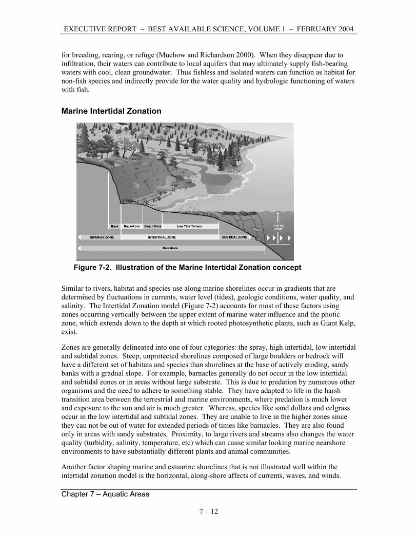
Marine Intertidal Zonation
Figure 7-2. Illustration of the Marine Intertidal Zonation concept
Similar to rivers, habitat and species use along marine shorelines occur in gradients that are determined by fluctuations in currents, water level (tides), geologic conditions, water quality, and salinity. The Intertidal Zonation model (Figure 7-2) accounts for most of these factors using zones occurring vertically between the upper extent of marine water influence and the photic zone, which extends down to the depth at which rooted photosynthetic plants, such as Giant Kelp, exist.
Zones are generally delineated into one of four categories: the spray, high intertidal, low intertidal and subtidal zones. Steep, unprotected shorelines composed of large boulders or bedrock will have a different set of habitats and species than shorelines at the base of actively eroding, sandy banks with a gradual slope. For example, barnacles generally do not occur in the low intertidal and subtidal zones or in areas without large substrate. This is due to predation by numerous other organisms and the need to adhere to something stable. They have adapted to life in the harsh transition area between the terrestrial and marine environments, where predation is much lower and exposure to the sun and air is much greater. Whereas, species like sand dollars and eelgrass occur in the low intertidal and subtidal zones. They are unable to live in the higher zones since they can not be out of water for extended periods of times like barnacles. They are also found only in areas with sandy substrates. Proximity, to large rivers and streams also changes the water quality (turbidity, salinity, temperature, etc) which can cause similar looking marine nearshore environments to have substantially different plants and animal communities.
Another factor shaping marine and estuarine shorelines that is not illustrated well within the intertidal zonation model is the horizontal, along-shore affects of currents, waves, and winds.

EXECUTIVE REPORT – BEST AVAILABLE SCIENCE, VOLUME 1 – FEBRUARY 2004
Chapter 7 – Aquatic Areas
7 – 13
Drift cells are systems in which sediment is suspended by waves or currents and transported along the shoreline in a repetitious cycle of suspension and deposition. Essentially, they are the mechanism that supplies marine nearshore environments with the majority of the sediments that form beaches, sand and mud flats, and maintains rarer features like sand spits and their associated marshes.
7.2.5 Effects of Land Development on Aquatic Habitats and Species
Land development (e.g., houses, landscaping, clearing, agricultural activity, roads, piers, gravel mining, bridge building, filling, bank armoring, bulk-heading) can significantly alter the natural habitat structures and processes to which native plants and animals are adapted. (See Chapter 2 – Scientific Framework and Context). Depending on the type of habitat affected, biological consequences include changes in the quantity and quality of spawning, rearing, migration, and disturbance refuge habitats, availability and quality of food, greater exposure to predators and increased competitive interactions. The effects of development varies with where it occurs in relation to the aquatic area. Three locations are discussed below: (1) at the edge of, on top of, or within an aquatic area; (2) in floodplains and riparian corridors; and (3) occurs far away from water.
Development that occurs at the edge of, on top of, or within, an aquatic area can affect the quantity and quality of aquatic habitats by directly eliminating a habitat or altering natural processes that support it, such as bank erosion, channel migration, and the delivery and transport of sediment and woody debris. Bortleson et al. (1980), Canning and Shipman (1995), Crzastowoski (1983), Haas and Collins (2001) and King County (1993) document dramatic changes in marine and freshwater habitat as a result of human development occurring within, on top, or at the edge of aquatic areas. Williams and Thom (2001) provide an extensive discussion of the effects of shoreline modification on marine and estuarine habitats and species. Similarly, Nightingale and Simenstad (2001) provide an extensive review of effects of overwater structures (e.g., docks and piers). Kelty and Bliven (2003) summarize a NOAA workshop, which evaluated the status of the science on the environmental and aesthetic impacts of small docks and piers. Effects of such activities and structures include changes in currents, amount and transport rates of shoreline sediment and woody debris, changes in night-time ambient light levels (developed areas are often much brighter at night due to lighting), introductions of toxic chemicals, and reductions in the quantity and quality of habitat.
Development in floodplains and riparian corridors affects aquatic areas when it removes or modifies native forest vegetation, or when it alters rates and patterns of bank and channel erosion, migration, surface, and groundwater flow. Riparian areas provide a variety of functions including shade, temperature control, water purification, woody debris recruitment, channel, bank and beach erosion, sediment delivery, and terrestrial-based food supply (Gregory et al. 1991; Naiman 1998; Spence et al.1996). These are potentially affected when riparian development occurs (Waters 1995; Stewart et al. 2001; Lee et al. 2001). Bolton and Shellberg (2001) provide an extensive discussion of the effects of riparian and floodplain development on aquatic habitats and species. Effects include: (1) reduction in amount and complexity of habitat; (2) increased scouring of channels due to channel and floodplain confinement; (3) reduction or loss of channel migration, vegetation, sediment supply; and (4) woody debris recruitment.

EXECUTIVE REPORT – BEST AVAILABLE SCIENCE, VOLUME 1 – FEBRUARY 2004
Chapter 7 – Aquatic Areas
7 – 14
Even development that occurs far away from water has the potential to affect aquatic habitat primarily by modifying water storage and runoff patterns and sediment erosion rates (Booth 1989; Harr et al. 1975; Hicks, et al. 1991; Booth and Reinelt 1993; Booth and Jackson 1997; Booth and Henshaw 2001; Booth et al. 2002). Booth and Reinelt (1993) found that when a watershed reaches approximately 10 percent effective impervious area, that demonstrable, and probably irreversible, loss of aquatic system function occurs in western Washington streams. They and May et al. (1997) also note that detrimental effects were evident well before the 10 percent threshold was reached.
Wherever it occurs, development has the potential to affect species migration and dispersal patterns by isolating habitats and fragmenting the landscape (McKinney 2002). It also tends to expose plants and animals to unnatural and potentially very harmful chemicals (Scholz 2000), and puts people and their pets in close proximity to native plants and animals that may not be tolerant of them (Baker and Haemmerle 1990).
There are many ways in which these changes affect plants and animals. In general, the physical and chemical effects are to create hydraulically simplified and/or polluted aquatic habitats with disturbance regimes much different from pre-development conditions (e.g., dramatically more or less intensity or frequency of flooding, erosion, or fire). In turn, native species diversity, distribution, abundance and productivity is lost or greatly reduced, especially among the most pollution intolerant species. Oftentimes these changes contribute to, or their effects are exacerbated by, invasions of undesirable, pollution-tolerant invasive or exotic species (May et al. 1997; Harding et al. 1998; Frissel 1993; McKinney 2002; Waters 1995; Stewart et al. 2001).
7.2.6 Processes Conclusion
Aquatic areas and the native species that use them have evolved in response to processes that reflect the ongoing interactions of water, soil, vegetation communities and animals at local, regional and global scales over long temporal scales (hundreds to millions of years). The sustainability and restoration of these habitats and species will require protection and, to the extent feasible, restoration of the ecological processes that sustain them as well as direct protection of the habitats themselves. Without providing substantial habitat protection, development will cause reductions (sometimes very dramatic) in productivity and species diversity, and contribute to damage caused by invasive, pollution tolerant and exotic species, which commonly benefit from habitat degradation.
Salmonids are the most studied and valued group of aquatic animals in the Pacific Northwest. They are widely distributed, a focus of legal and social concerns, and exhibit responses including loss of productivity and inter- and intra-specific diversity to development-related impacts. As a result they are considered both keystone and indicator species and are an often-used benchmark for environmental health and performance. Their use as such is complicated, however, by the influence of harvest, hatcheries, and ocean conditions. Other species, such as amphibians, molluscs, and insects may be better indicators, depending on the effect and habitat being assessed.

EXECUTIVE REPORT – BEST AVAILABLE SCIENCE, VOLUME 1 – FEBRUARY 2004
Chapter 7 – Aquatic Areas
7 – 15
7.2.7 Strategies for Protection
Protective measures, such as proposed in the CAO and Stormwater ordinances should be part of a comprehensive and integrated habitat and species protection and restoration strategy. Such a strategy prioritizes areas based on their biological potential, sets realistic (i.e., socially as well as ecologically achievable goals) and objectives accordingly (Roni et al. 2002; IMST 2001), and recognizes natural and human-induced variations in physical, chemical and biological conditions. Critical to understanding this variation is information on the following four parameters (IMST 2001; National Research Council 1996): (1) spatial structure of the watershed; (2) temporal and natural disturbance history; (3) riparian vegetation community; and (4) nature and magnitude of human impacts.
Because protection measures (regulatory, capital investment, or programmatic), entail monetary and social costs, it is important to apply them where they will provide the most benefit to the aquatic area. An emerging generalized strategy for conservation is to first protect the best remaining habitats, and then, to the extent feasible, restore those that are impaired (Roni et al. 2002; IMST 2001; NRC 1996).
In order to pursue the above strategy, it is necessary to protect or restore the processes that sustain habitats, and not just the habitat themselves. Many aquatic areas in King County are already severely degraded. In some heavily urbanized areas it is unrealistic to expect full restoration of habitat (Booth et al. 2002). For example, aquatic areas in or downstream of high-intensity land-use areas (cities, unincorporated urban lands, high intensity agricultural lands) are generally degraded with severity of degradation increasing with proximity to high intensity land-use. Wider buffers acting along a downstream gradient can ameliorate but not completely reverse these effects (Morley and Karr 2002). Certain localized conditions such as the presence of large amounts of highly porous outwash and relatively flat landscapes and channels can also help to reduce the effects. Where large buildings and major infrastructure surround or encroach into aquatic areas, options for future restoration are likely to be limited because of the extremely high cost of removing such structures. Conversely, aquatic areas in or downstream of lower-intensity land uses are generally in better condition and offer more cost-effective opportunities for protection and restoration.
This gradation of development, habitat conditions and future restoration options has implications for protection strategies. For example, there may be a point beyond which requiring wider buffers or forest cover in areas of existing high-intensity land use (i.e., where parcels are small and few remain undeveloped) is ineffective at meeting habitat or biological goals. In this context, higher protections may be best applied in areas where comprehensive protection and/or substantial restoration are realistic goals (i.e., achievable given socioeconomic constraints), a subjective standard but nonetheless a threshold that does exist. Similarly, in areas that are highly constrained by intense development, it may be best to focus protective actions on functions such as improving water quality and overhead shade, which are achievable with smaller buffers, rather than large woody debris recruitment and microclimatic controls which require wider buffers to achieve substantial results.
While restoration might be possible in intensely developed areas, it would likely entail highly engineered and costly solutions. Buffers in low-intensity land-use areas can potentially better protect habitat and preserve future restoration options than buffers in highly urbanized areas. Placing a higher priority on protecting areas with high habitat restoration or species recovery
EXECUTIVE REPORT – BEST AVAILABLE SCIENCE, VOLUME 1 – FEBRUARY 2004
Chapter 7 – Aquatic Areas
7 – 16
potential is consistent with recommendations for protection of aquatic resources in developing areas (Booth et al. 2002; Roni et al. 2002) and for salmonid recovery (Spence 1996).
In addition, the location and condition of habitats, biological resources and watershed processes are factors to consider in aquatic area protection measures. Finally, Puget Sound headwater areas tend to have the least development (with some notable exceptions for small lowland streams fully encased in urban development, e.g., Thornton, Hamm, Kelsey and Longfellow Creeks). Therefore, relatively high protection of headwater areas and their streams may offer the greatest systemic benefits for the protection of certain functions, such as water quality protection, hydrology and sediment routing, critical to streams. This is not to imply other parts or features of a watershed are insensitive or have any lesser importance, rather that it is important to understand the role and issues relative to the watershed location.
Similarly, the condition and distribution of key biological resources also plays a role in a comprehensive protection strategy. Thus buffers of sufficient width and condition to provide direct protection of fish (i.e., on fish-bearing streams) may be unnecessary on streams with low numbers of fish or no critical fish species. Local knowledge of the distribution and relative condition of fish and other aquatic biota is increasing in Puget Sound (see for example King County fish and benthic invertebrate maps, WRIA Near-Term Action Agenda plans and State Limiting Factor Reports). However, while much improved over historic information, the reliability of some of this information is uncertain and the uses of many aquatic habitats by key biota remains unknown. In the face of uncertainty some level of conservatism in setting protections is warranted, as land-use decisions are often irreversible. To this end, the need to protect waters with salmonid-bearing potential, not just those known with high certainty to have salmonids, should be considered until their biological role is well known.
7.2.8 Approaches to Aquatic Area Protection
Effective protection measures should provide protections for both critical habitats as well as ecological processes (water flow, sediment routing, vegetation succession, woody debris processing, and plant and animal speciation) that sustain them. Aquatic areas, the species that use them, and the ecological processes that sustain them occur at multiple habitat (aquatic, riparian and landscape) and time (days to centuries and longer) scales. Therefore protections should address potential impacts protection needs at those multiple scales (Booth and Reinelt 1993). This means having regulations that protect aquatic habitats from direct harm from in-water and riparian activities as well as protecting key riparian and upland functions that sustain aquatic habits.
In lieu of effective protection standards, many attempts have been made to mimic natural processes, such as through artificial stormwater or streambed controls, or hatcheries. Unfortunately, such approaches generally have been found to be ineffective or counter-productive and costly substitutes for natural conditions (see Booth 1989, 1991; Booth et al. 2002; National Research Council 1995; Roper et al. 1998; Frissel and Nawa 1992). In some cases where larger landscape processes were not adequately considered, they have generated additional problems and costs rather than being the hoped-for solution (Kondolf 2000; Booth et al. 2002).
Some extensively urbanized parts of the landscape may be irreversibly impacted (Booth and Reinelt 1993; Booth et al. 2002). In such situations, artificial, highly engineered measures such as stormwater ponds, piping systems, and retrofitting of stream channels with artificial bed

EXECUTIVE REPORT – BEST AVAILABLE SCIENCE, VOLUME 1 – FEBRUARY 2004
Chapter 7 – Aquatic Areas
7 – 17
controls may be the only realistic choices left. Where such thresholds have not been reached, however, planning for and accommodating natural rates of change is considered one of the keys to sustaining aquatic habitats and the species that use them. In order for this to happen, it is necessary to maintain or restore where impaired, the processes that allow water, soil, vegetation, and animals to interact (i.e., connectivity, see Chapter 2 – Science Framework).
Riparian Areas
Riparian Functions
Natural riparian corridors provide an extremely wide range of highly valuable functions. In addition to being important habitats in their own right for a wide range of wildlife (Knutson and Naer 1997), they are also considered essential for sustaining wild fish populations (Naiman et al. 1993). Naiman et al. (1993) notes that riparian areas are the most diverse, dynamic, and complex biophysical habitats on the terrestrial portion of the Earth” (Naiman et al. 1993). The Puget Sound area’s wild salmonids are adapted to thrive in forest-lined fresh waters during significant parts of their life cycles and depend on the riparian system’s diversity, dynamism, and complexity. There is no known suitable, long-term substitute for healthy riparian forest as a generator of habitat for Puget Sound’s salmonids and a myriad of other fish and wildlife.
Gregory et al. (1997) stated that before the widespread removal of riparian forests in the Northwest’s lower valley floodplains, the forests were critical for moderating the effects of winter floods and summer and winter temperature extremes by providing refugias, particularly along secondary channels and off-channel ponds (referencing Ward et al. (1942), Peterson and Reid (1984), and Brown and Hartman (1988)). Pollack and Kennard (1998) point out that “riparian buffers are the key component of any salmonid habitat conservation strategy because they … provide the majority of the ecological goods and services required to keep salmonid habitat functional.”
Protection of Puget Sound’s native salmonids is aided by the presence of healthy riparian forests. In their natural state, riparian areas are generally dominated by coniferous trees, usually Douglas fir, western hemlock, and western red cedar (Brosofske et al. 1997; May 2000) but a certain portion are in less advanced stages of succession to disturbances, and may be dominated by other woody species such as alder, cottonwoods or maples, or perhaps even meadows. The result is a complex array of riparian habitats contributing to the species diversity of an area.
However, many species compose the native riparian plant communities. Some riparian vegetation is characterized as obligate, for species growing only in riparian areas, and some as facultative, for species commonly occurring there but also in upland terrain. Obligate riparian plants tend to depend on a high water table, tolerate inundation and soil anoxia, tolerate physical damage from floods, colonize flood-scoured surfaces, and colonize and grow in substrates having few soil nutrients (Kondolf et al. 1996).
In summary, healthy riparian zones are living, ever-changing systems, often undergoing natural disturbance (flood, drought, fire, landslide, insect infestation, etc.), then responding via self-regeneration. These dynamic riparian ecosystems perform various functions that form salmonid habitat. Below are descriptions of some of the commonly cited major functions.

EXECUTIVE REPORT – BEST AVAILABLE SCIENCE, VOLUME 1 – FEBRUARY 2004
Chapter 7 – Aquatic Areas
7 – 18
1. Producing and delivering large and small woody debris (LWD and SWD) to shorelines and stream channels. The important role of fallen trees and tree parts as structure-forming elements in stream channels is well known (Zimmerman et al. 1967; Heede 1972; Swanson et al. 1976; Swanson and Lienkaemper 1978; Keller and Swanson 1979; Bilby and Likens 1980; Bilby 1981; Lisle and Kelsey 1982; Megahan 1982; Harmon et al. 1986; Lisle 1986; Bisson et al. 1987; Leinkaemper and Swanson 1987; Andrus et al. 1988; Bilby and Ward 1989; Hartman and Scrivener 1990; Robison and Beschta 1990; Bilby and Ward 1991; Maser and Sedell 1994; O‘Connor and Harr 1994; Montgomery et al. 1995; Beechie and Sibley 1997; Montgomery and Buffington 1997; Bilby and Bisson 1998; Pollack and Kennard 1998). Major salmonid habitat benefits of woody debris are apparent (Bustard and Narver 1975; Bisson et al. 1982; Tschaplinski and Hartman 1983; Grette 1985; Sullivan et al. 1987) (Hartman and Scrivener 1990). The complex, submerged structure formed by LWD and SWD (and roots of woody vegetation) provides flow refugia (McMahon and Hartman 1989) and essential cover in which salmonids conceal themselves from enemies and competitors and find profitable feeding positions, as inferred from observations in natural streams (Fausch and White 1981) and experiments in a stream aquarium (Fausch 1984; Fausch and White 1986).
Removal of riparian forest results in long-term reduction of LWD (McDade et al. 1990; Van Sickle and Gregory 1990) and SWD (Bilby and Ward 1991) in streams. LWD deprivation leads to adverse changes in channel forming processes (Bilby 1984; Bisson and Sedell 1984; Heifetz et al. 1986), and a marked decrease in salmonids result (Lestelle 1978; Bryant 1983; Dolloff 1986; Elliot 1986; Fausch and Northcote 1992). Reduced LWD is deemed a major reason for salmonid decline in Pacific Northwest streams ((Sedell and Luchessa 1981; Sedell and Froggart 1984; Bisson et al. 1987; Sedell et al. 1989; FEMAT 1993; Stouder et al. 1997; Naiman and Bilby 1998).
One of the pertinent functions of LWD in streams is that it traps and accumulates smaller WD and other organic matter (Bilby 1981), including salmon carcasses. Pollack and Kennard (1998) reviewed roles of SWD in streams and developed a procedure for estimating potential SWD delivery from riparian areas. WD in non-fish-bearing streams also benefits downstream salmonids by regulating sediment flow (Megahan 1982; Perkins 1989; Montgomery et al. 1996).
2. Shoreline protection, bank stabilization, and habitat formation. The effectiveness of riparian vegetation is well known to naturally stabilize stream banks while providing structural habitat for salmonids. The vegetation also influences water current and shoreline shape in other ways that benefit salmonid habitat. As reviewed in Spence (1966), roots bind streambank soils, and stems, branches, and projecting roots slow water currents that bear against riparian areas. The cover of healthy, native-plant communities generally perform this function more beneficially for salmonid habitat than do artificial reinforcements made of rock or other hard, non-living materials.
The riparian vegetation that protects shorelines also provides structural habitat for aquatic organisms, such as many salmonid microhabitats in live vegetation and in woody debris (see item 1, above). This material, most important being tree roots and brush that drapes into the water, creates positions that are concealed from predators and give shelter from water velocity but are near fast currents that bring food (Bossu 1954; Fausch 1984; Fausch and White 1986). Vegetation resists shoreline erosion but generally not as drastically as do rock-riprap, concrete bulkheads, steel sheet-piling, and the like. Diverse native vegetation can be

EXECUTIVE REPORT – BEST AVAILABLE SCIENCE, VOLUME 1 – FEBRUARY 2004
Chapter 7 – Aquatic Areas
7 – 19
expected to moderately retard shoreline erosion while maintaining their dynamism, letting channels flex, thus forming and reforming salmonid habitat features. Reeves (et al. 1995) described the dynamism of salmonid-producing ecosystems in the Pacific Northwest and put forth ideas for managing them so as to accommodate disturbance regimes.
3. Removing sediments and dissolved chemicals from water. Uptake of dissolved chemicals and filtration of sediments from overland-runoff and flood water is an important riparian function(Lowrance et al. 1984; Cummins et al. 1994). Spence (1966) reviewed evidence for these processes and for alteration of the flux of these material through stream systems. Literature analysis by (FEMAT 1993) indicated that healthy riparian zones greater than 200 feet from the edge of the floodplain probably remove most sediment from overland flow. The chemicals that constitute plant nutrients may be largely incorporated in the riparian zone’s biomass. This and deposits of sediment contribute to the building of “new land” involved in channel or shoreline migration. Any action, such as clearing, that degrades the integrity of the riparian zone will hamper its functions of chemical filtering, uptake, and of land-building.
4. Moderating water temperature. Thermal benefits of shading by riparian vegetation in summer are obvious (Hall and Lantz 1969; Brown and Krygier 1970; Newbold et al. 1980; Beschta et al. 1987; Holtby 1988). Aside from summer cooling, riparian forest cover also exerts winter-insulating effects (Murphy and Meehan 1991). Spence (1966) reviewed studies that elucidate riparian thermal benefits.
5. Providing favorable microclimate. Less obvious but perhaps no less important are the microclimatic influences of the riparian forest on air that passes through on its way to a stream or pond. These include are matters of humidity, temperature, and wind speed, as reviewed in Pollack and Kennard (1998). Brosofske et al. (1997) documented that riparian microclimate is important to consider in management because it affects plant growth, therefore influencing ecosystem processes such as decomposition, nutrient cycling, plant succession, and plant productivity. Thus microclimate alterations can affect structure of the riparian forest, the waters within it, and the well-being of many animals, including fish.
6. Providing habitat for terrestrial animals. Various animals that live in or frequent riparian zones are associated with salmonid populations. These include habitat modifiers, such as moose and beaver (Naiman and Rogers 1997), the former altering vegetation, the latter (Bustard and Narver 1975; Cederholm and Scarlett 1982; Murphy et al. 1989) making ponds, digging side channels, and altering vegetation. In addition, riparian-dwelling predators, such as otter and various birds, exert beneficial selective pressure on fish populations by removing weak or maladapted individuals. Predators and scavengers recycle nutrients from salmonid carcasses. These relationships are reviewed for Washington and Oregon in Cederholm (et al. 2000), which contains 576 references.
7. Providing proper nutrient sources for aquatic life. Riparian trees and other vegetation furnish water bodies with a “litter fall” of plant particles (leaves, pollen grains, etc.), as well as with terrestrial insects. These organic materials compose a major energy source for food webs that sustain production of salmonids, particularly in small (low- and mid-order) streams (Gregory et al. 1991; Naiman et al. 1992; Cummins et al. 1994). Along smaller stream channels, litter fall from healthy stands of riparian vegetation (an allochthonous source) is a relatively more important basis for the aquatic food web than is within-channel (autochthonous) production of algae, which tends to predominate as the basis for the aquatic

EXECUTIVE REPORT – BEST AVAILABLE SCIENCE, VOLUME 1 – FEBRUARY 2004
Chapter 7 – Aquatic Areas
7 – 20
food web in wider, less shaded streams and in standing waters (Vannote et al. 1980). Clearing and certain other subsequent actions obviously reduce or destroy the nutrient-providing function of riparian vegetation.
Note that many of these seven major functions are interrelated, that all are performed primarily by vegetation, and that all are decreased or eliminated when riparian vegetation is degraded or destroyed.
Further riparian functions important to salmonids include exchange of water between the ground and the water body (hyporeal flow, Stanford and Ward, 1988); flux of gravel between stream beds and banks, and light patterning which salmonids (Gibson and Keenleyside 1966; MacCrimmon and Kwain 1966; Butler and Hawthorne 1968; Stewart 1970; Bassett 1978; DeVore and White 1978; Gruber 1978) and invertebrates (Myers and Resh 2000) use for concealment.
Approaches to Protecting Riparian Functions
The most common method for protecting vegetation and its riparian functions from adjacent land uses has been the use of buffers. Castelle and Johnson (1998) define buffers as vegetated zones located between natural resources, such as streams, wetlands, or critical wildlife habitat, and nearby areas subject to human alteration. Fixed riparian buffers are intended to protect an area of sufficient size to provide functions considered important for protecting aquatic and riparian species and to buffer against development impacts (Haberstock et al. 2000). Key functions considered in establishing the width of buffers include shade and temperature regulation, flood conveyance, water quality protection and pollutant removal, nutrient cycling, sediment transport, bank stabilization, woody debris recruitment, wildlife habitat and microclimate control (Spence et al. 1996; IMST 2001; May 2000).
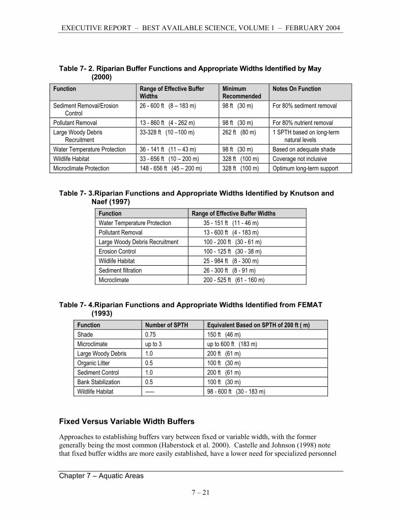
A variety of technical reports summarize the scientific literature on buffer functions and make recommendations for buffer widths. Findings of three such reports are shown in Tables 7-2, 7-3, and 7-4; (from Parametrix 2002). Others include Castelle et al. (1992), Castelle and Johnson (2000), Desbonnet et al. (1994), Johnson and Ryba (1992), Portland Metro (1999) and Pollack and Kennard (1998).
EXECUTIVE REPORT – BEST AVAILABLE SCIENCE, VOLUME 1 – FEBRUARY 2004
Chapter 7 – Aquatic Areas
7 – 21
Table 7- 2. Riparian Buffer Functions and Appropriate Widths Identified by May (2000)
Function Range of Effective Buffer Widths
Minimum Recommended
Notes On Function
Sediment Removal/Erosion Control
26 - 600 ft (8 – 183 m) 98 ft (30 m) For 80% sediment removal
Pollutant Removal 13 - 860 ft (4 - 262 m) 98 ft (30 m) For 80% nutrient removal Large Woody Debris
Recruitment 33-328 ft (10 –100 m) 262 ft (80 m) 1 SPTH based on long-term
natural levels Water Temperature Protection 36 - 141 ft (11 – 43 m) 98 ft (30 m) Based on adequate shade Wildlife Habitat 33 - 656 ft (10 – 200 m) 328 ft (100 m) Coverage not inclusive Microclimate Protection 148 - 656 ft (45 – 200 m) 328 ft (100 m) Optimum long-term support
Table 7- 3.Riparian Functions and Appropriate Widths Identified by Knutson and Naef (1997)
Function Range of Effective Buffer Widths Water Temperature Protection 35 - 151 ft (11 - 46 m) Pollutant Removal 13 - 600 ft (4 - 183 m) Large Woody Debris Recruitment 100 - 200 ft (30 - 61 m) Erosion Control 100 - 125 ft (30 - 38 m) Wildlife Habitat 25 - 984 ft (8 - 300 m) Sediment filtration 26 - 300 ft (8 - 91 m) Microclimate 200 - 525 ft (61 - 160 m)
Table 7- 4.Riparian Functions and Appropriate Widths Identified from FEMAT (1993)
Function Number of SPTH Equivalent Based on SPTH of 200 ft ( m) Shade 0.75 150 ft (46 m) Microclimate up to 3 up to 600 ft (183 m) Large Woody Debris 1.0 200 ft (61 m) Organic Litter 0.5 100 ft (30 m) Sediment Control 1.0 200 ft (61 m) Bank Stabilization 0.5 100 ft (30 m) Wildlife Habitat ----- 98 - 600 ft (30 - 183 m)
Fixed Versus Variable Width Buffers
Approaches to establishing buffers vary between fixed or variable width, with the former generally being the most common (Haberstock et al. 2000). Castelle and Johnson (1998) note that fixed buffer widths are more easily established, have a lower need for specialized personnel
EXECUTIVE REPORT – BEST AVAILABLE SCIENCE, VOLUME 1 – FEBRUARY 2004
Chapter 7 – Aquatic Areas
7 – 22
with a knowledge of ecological principles, and require less time and money to administer. Conversely, they note that variable width buffers can potentially allow for greater flexibility, account for variation in site conditions and land management practices, and potentially achieve desired ecological goals while minimizing undue losses to landowners. Variable width buffers are considered more ecologically sound because they have the potential to reflect the true complexity of the environment and management goals (Haberstock et al. 2000; IMST 2001). Todd (2000 as cited in May 2000) suggests that variable width buffers provide the best protection while respecting property rights. While variable-width buffers may be more ecologically sound and theoretically allow landowners more flexibility, there are no generally accepted criteria for the establishment of variable-width buffers. To be effective under a worst-case scenario and to ensure success in the face of uncertainty about specific site conditions, May (2000) and Haberstock (2000) suggest that fixed-width buffers should be designed conservatively (i.e., larger than the bare minimum needed for protection).
Variable width buffer approaches have been proposed by Forman (1995) and, as cited by Castelle and Johnson (1998) by Darling et al. 1982, Steinblums et al. (1984), Barton et al. (1985), Roman and Good (1985), Budd et al. (1987), and Groffman et al. (1990). Haberstock et al. (2000) provides recommendations for a variable width two-zone approach for the protection of endangered Atlantic salmon habitat. In their approach, Zone One is a fixed 35-ft (10.7-m) width closest to the water in which no disturbance should occur. Zone Two is a variable-width area wherein limited low-impact uses (recreation, low-impact forestry) that do not compromise the desired functions of the buffer could be allowed. Total buffer widths (Zone One plus Zone Two) range from a minimum of 70 feet (21 m) to 400 feet (122 m), with a maximum of 1,000 feet (305 m) in rare cases, such as along streams that are flanked by extensive steep (> 25 percent) slopes.
Adjustments in Zone Two width can be made for the presence of surface and groundwater seepage features, forest floor roughness, sand and gravel aquifers, wetlands, floodplains, very steep slopes, and stream order. All but one of the adjustment factors (the degree of forest floor surface roughness) causes Zone Two to increase. These authors note that buffer widths are expected to vary regionally as a function of buffer conditions, management objectives, and instream habitat characteristics. They also note that theirs is a conceptual model and potentially subject to change as studies and scientific literature provide new data that better indicate the relationships between buffer characteristics and buffer effectiveness.
There is no consensus in the scientific literature regarding single buffer widths for particular functions, or to accommodate all functions. However, neither does the literature indicate that buffers are not needed, nor that riparian buffers beyond the equivalent of several site potential tree heights (SPTHs) are needed. One SPTH, the maximum height a tree will attain given the existing geology, soils, and other site conditions, ranges from 50 to 250 feet (15-76 m), depending on species, for a tree at least 300 years old in western Washington forests. A buffer width equal to one SPTH would provide for a broad range of riparian functions important for sustaining salmonids. However, some wildlife, such as stream breeding amphibians, beavers and other mammals, may need considerably more than this for land migrations associated with foraging and breeding (see Chapter 8 – Wildlife Areas).
The type and intensity of human activities in and near buffers are factors not often assessed in reviews of buffer widths, but they can affect conditions in the buffer. In a survey of 62 Native Growth Protection Easements (NGPEs) along streams, wetlands, and steep slopes in developing areas of western King County, Baker and Haemmerle (1990) found that the vegetated condition

EXECUTIVE REPORT – BEST AVAILABLE SCIENCE, VOLUME 1 – FEBRUARY 2004
Chapter 7 – Aquatic Areas
7 – 23
of two-thirds of the NGPEs had been altered by people, and of those, 25 percent had been judged as being negatively affected. Moreover, the number and seriousness of impacts increased with increasingly intense residential development near the NGPEs. May (2000) suggests that more protective buffers are needed for more sensitive or valuable resources. Similarly, he suggests that more protective buffers should be applied for higher intensity land uses or when the land use poses higher risk of impact.
Site Potential Tree Height Concept
The concept of scaling riparian buffer widths to the potential height of a tree was first proposed by the Federal Ecosystem Management Team who was assessing riparian protections for national forest lands (FEMAT 1993). They reasoned that trees were a logical scaling factor because (1) they are a dominant factor in determining habitat conditions and (2) when left unmanaged, their size (height) reflected inherent productivity and constraints of a given site. As a result of this logic generalized curves using scientific data and professional judgment were developed to help rate buffer effectiveness for a variety of ecological functions, including shade, litter fall (e.g., leaves, branches), root strength and coarse woody debris inputs. Curves for a set of factors (soil moisture, radiation, soils temperature, air temperature, wind speed, and relative humidity) relating to microclimate were also developed. These curves are shown in Figure 3.
Based on these curves, all but microclimate functions would likely be protected with a buffer width equivalent to one SPTH. Microclimate functions would need approximately three SPTH for full protection.
Sedell et al. (1993) defined a SPTH as the average maximum height to which a dominant tree will grow if left undisturbed. Depending on the species, soils, climate, disturbance history of a site a dominant tree could be between 200 to 500 years old. Pollock and Kennard (1998) provide detailed explanation of a SPTH. Using tree growth information for two riparian plant association groups (PAGs) on the Mount Baker-Snoqualmie National Forest, they estimate the SPTH for Douglas Firs would range from 218 to 198 feet for PAGs four and five, respectively. Similar data are not readily available for other trees, such as western red cedar, sitka spruce, which can be as tall or taller than Douglas Firs, depending on site conditions, or for black cottonwood, red alder and bigleaf maple, which are smaller in maximum height and therefore would likely have smaller SPTH values than for Douglas fir. Soil surveys by the U.S. Department of Agriculture, Soil Conservation Service, typically provide estimates of tre,e height for given soils (USDA 1992). However the information is based on growth achieved in fifty or 100-years and thus do not represent a site’s SPTH for longer lived trees such as Doug firs, western red cedars or sitka spruce. For example, for Alderwood soils, which are the dominant soils for King County, the average height of a 100-year Doug fir would be 146 feet, roughly 75 to 80 percent of the SPTH assuming a 300-year-old tree (Pollock and Kennard 1998).
Marine Near-Shore, Estuarine, Lake and Pond Habitats
Riparian buffer literature cited above is derived primarily from work pertaining to streams, rivers and wetlands. Few data exist on the marine-riparian interface in the Pacific Northwest (Levings and Jamieson 2001). However, in many ways the needs of marine nearshore habitats are similar to those of streams and rivers and thus the buffer widths recommended for riverine habitats are also applicable to marine nearshore habitats. For example, as with streams, riparian areas can contribute significant amounts of food for marine fish. Duffy et al. (2002) found that terrestrial

EXECUTIVE REPORT – BEST AVAILABLE SCIENCE, VOLUME 1 – FEBRUARY 2004
Chapter 7 – Aquatic Areas
7 – 24
invertebrates made up a large contribution of the diet of fishes in north Puget Sound. A study of marine fishes along King County shorelines also found terrestrial insects were a significant part of the diet of juvenile salmon (Jim Brennan pers. comm., August 2003). Also, marine shorelines can be viewed as similar to riverine shorelines because of energy from tides, waves and currents, i.e., their condition is influenced by energy that scours, transports and deposits sediment and woody debris. Woody debris in marine nearshore environments is derived both from onsite vegetation and transported from offsite locations subject to longshore currents. Marine nearshore woody debris also contributes nutrients to nearshore environment, and is a major component in forming and maintaining shoreline structural habitat (Everett and Ruiz 1993).
With respect to the value of buffers for temperature and shading in the marine nearshore environment, Levings and Jamieson (2001) note that the temperature of surficial and interstitial water emanating from marine riparian areas and flowing into marine nearshore habitats may be affected by shading. Pentilla (2001) found that reduced survival of surf smelt eggs was related to reduced shade from trees overhanging marine nearshore spawning habitats. Freshwater aquifers emanating from underneath a riparian forest can discharge into the intertidal zone, creating localized fresh and brackish water habitats. Levings and Jamieson (2001) suggest that populations of some species of prey for marine fish (e.g., the amphipod Paramoera bousfieldi, Staude 1984) may be adapted to cool freshwater seeps as well as brackish conditions. The integrity of such aquifers and seeps could be affected by the integrity of the riparian vegetation (Levings and Jamieson 2001).
Levings and Jamieson (2001) also conducted a review of the literature pertaining to buffer width recommendations for protection of marine riparian habitat in British Columbia, Washington State and Alaska. Depending on shore class, recommended marine buffers zones in British Columbia range from approximately 300 feet (100 m) for Class B marine shores to approximately 450 feet (150 m) for Class A (1) and A (2) shores (those with low banks adjacent to open waters) (Ministry of Forests 1996; Saanich Inlet Study 1996, both as cited in Levings and Jamieson 2001). In Washington State, the Shoreline Management Act sets a buffer zone of one-half SPTH or 100 feet (30 m), whichever is greater (Anon. 2001). In Chesapeake Bay, forest buffers of 35 to 125 feet (11 - 38 m) are recommended, depending on pollutant loading and site conditions (Palone and Todd 1977, as cited in Levings and Jamieson 2001). In addition, in the Tongass National Forest, protection is recommended for a 1,000-foot-wide (305 m) beach fringe of mostly unmodified forest, primarily for wildlife habitat protection (U.S. Forest Service 1997, as cited in Levings and Jamieson 2001).
Buffers for lakes and ponds are commonly prescribed, especially for protection of water quality. The basis for these prescriptions, however, seems to be derived from the literature for streams, rivers and wetlands, given the absence of scientific literature assessing functions or effectiveness of buffer widths for lakes and ponds. In a review of habitats and lakes, Schindler and Scheuerell (2002) note that studies of linkages between lakes and their riparian habitats are rare. Gasith and Hasler (1976, as cited in Schindler and Scheuerell) found that depending on riparian characteristics, shoreline complexity, and overall productivity of the aquatic system, litterfall from riparian vegetation can be a major source of organic matter to benthic and pelagic lake habitats. In some instances, terrestrial insects can provide substantial inputs of prey for lake dwelling predators and contribute to lake nutrient cycles (Carlton and Goldman 1984; Cole et al. 1990, both as cited in Schindler and Scheuerell). Schindler and Scheuerell (2002) also note that there has been almost no research on the roles of coarse woody debris (CWD) as habitat in lake

EXECUTIVE REPORT – BEST AVAILABLE SCIENCE, VOLUME 1 – FEBRUARY 2004
Chapter 7 – Aquatic Areas
7 – 25
Figure 7 - 3. Riparian vegetation effectiveness as a function of the height of a site potential tree distance from the water’s edge.
Graph (a) shows cumulative effectiveness of four riparian processes as a function of relative distance from the edge of a stream, in fractions of a dominant tree height. Graph (b) shows cumulative effectiveness for six microclimate factors as a function of relative distance from the stream edge. Modified from FEMAT (1993) and Naiman et al (2000).
ecosystems. However, they note that based on decomposition rates and habitat complexity associated with macrophytes, CWD would be expected to play a major role in providing habitat structure that could regulate predator-prey interactions along shorelines and in deeper benthic areas.

EXECUTIVE REPORT – BEST AVAILABLE SCIENCE, VOLUME 1 – FEBRUARY 2004
Chapter 7 – Aquatic Areas
7 – 26
While woody debris is an important component of lake and pond habitat structure and serves as a nutrient source, it may be that it has less of a hydraulic function since erosive energy gradients along lake and pond shorelines are lower than those along riverine and marine shorelines. Wave action due to winds and fetch can be quite erosive on large lakes. In those places woody debris would be expected to play a role in dampening wave energy similar to its role in diffusing energy in stream channels. Temperature regulation by riparian vegetation is probably less critical since the overall thermal condition of lakes and ponds is regulated more by air temperature and temperature of tributary inputs than by microclimatic controls provided by surrounding riparian forests. However, spring seeps and surface runoff into lakes and ponds can create localized temperature gradients, and their temperature regimes could be influenced by riparian conditions. Also, the temperature of small spring-fed ponds and littoral lake habitats with northerly aspects may be influenced by the condition (height, width, species composition) of adjacent riparian forests. Other functions, such as terrestrial food sources, overhead shade (for hiding cover rather than temperature), bank stability, pollutant removal, etc., are likely similar for lakes and ponds as those affecting riverine and marine aquatic areas.
As with marine nearshore, lakes, and ponds, little has been written about the riparian needs of estuaries (Williams et al. 2001). Subject to tidal fluxes, their erosive energy is somewhat higher than for lakes and ponds and less than for streams, rivers, and marine shorelines, thus the hydraulic function of woody debris in estuaries would likely also be rather modest. However, estuaries often have areas of intense mixing either as a result of geomorphic constraints that focus tidal flow exchanges or due to extreme tidal fluxes during storms (Simenstad et al. 2000). Under such conditions, woody debris would play a similar hydraulic role as it does in more dynamic aquatic areas. Also, as with other habitats, woody debris plays a major role in providing estuarine habitat structure and contributes nutrients to estuarine ecosystems. Temperature regulation contributed by riparian vegetation on estuarine shorelines is probably less important than for streams and rivers, because overall estuarine temperatures are influenced primarily by marine and riverine inflows, depending on the type of estuary. However, as with the other aquatic areas, estuaries are likely to have seeps and other localized cool areas that may be affected by the extent and type of riparian habitat. Other functions, such as terrestrial food supply, overhead shade (for hiding cover rather than temperature moderation), bank stability, and pollutant removal (see Williams et al. 2001) are similar to those affecting other aquatic areas.
Protecting Landscape Scale Functions
Landscape scale measures (such as protection of forest cover) are needed to protect functions such as hydrology, sediment routing and nutrient cycling that largely originate in large part outside of the immediate riparian corridor (May 2000; Haberstock et al. 2000). Physical (severe erosion and flooding) and biological (loss of species productivity and diversity) effects tend to be more pronounced in heavily urbanized areas with considerable impervious surfaces (Booth and Reinelt 1993; Booth and Jackson 1997; May et al. 1997; Booth and Henshaw 2001) But they can also occur in relatively rural areas where impervious area is low but forest cover has been reduced (see Pess et al. 2002).
To help minimize impacts of development, a 65 percent forest retention standard has been implemented in selected watersheds of King County. For the Issaquah and Bear Creek Basins this is a requirement, while for the Lower Cedar River is a voluntary measure. (King County 1996; 1995 and 1998.) This 65 percent standard is being implemented through a 35 percent

EXECUTIVE REPORT – BEST AVAILABLE SCIENCE, VOLUME 1 – FEBRUARY 2004
Chapter 7 – Aquatic Areas
7 – 27
clearing restriction on rural residential zoned parcels within the selected watersheds. The Tri-County Model (2001) proposed a “65/10” standard for all rural residential zoned parcels. This standard called for retaining native vegetation on at least 65 percent of the parcel and restricting the amount of “effective impervious surface” to no more than 10 percent through application of runoff dispersion and infiltration techniques. The 65/10 standard was based on the estimated point when land use and land cover changes are observed to cause downstream channels to start to become seriously degraded (Booth 2000). While this 65/10 threshold is helpful in minimizing impacts, it is not sufficient for avoiding them, as measurable impact occurs at virtually any level of development (Booth et al. 2002). Booth et al. summarizes evidence of various aquatic resource damages associated with conversion of forest cover to impervious area, and the limitations and problems associated with reliance on traditional stormwater mitigation efforts such as detention ponds. They note that preservation of aquatic resources in developing areas must include impervious area limits, forest retention policies, stormwater detention, riparian buffer maintenance, and protection of wetlands and unstable slopes. Specific elements (landscape level and riparian) for effective protection recommended by Booth et al. include:
“clustered developments that protect half or more of the forest cover, preferably in headwater areas and around streams and wetlands to maintain intact riparian buffers; a maximum of 20 percent total impervious area, and substantially less effective impervious
area through widespread reinfiltration of stormwater (Konrad and Burges 2001); on-site detention, realistically designed to control flow durations (not just peaks); riparian buffer and wetland protection zones that minimize road and utility crossings as well
as overall clearing; and no construction on steep or unstable slopes.”
Finally, these authors stress that these recommendations rely on extrapolation, model results, and judgement and thus the specific values (not the concepts) are still tentative.
In summary, the key to attaining effective aquatic area protection against landscape level changes is maximizing native forest cover (including continuity of riparian areas along streams and wetlands) and minimizing impervious surfaces. Where this is not possible, conventional (albeit improved over historic practices) stormwater runoff controls that detain and clean stormwater to match predevelopment conditions in terms of timing and magnitudes of flows should be employed. In order to achieve this, it is critical to implement the most advanced and accurate methodologies to model stormwater runoff and treatment benefits such as the KCRTS model recommended by Jackson et al. (2001).
7.2.9 Strategies for Protection Conclusion
Historically, protection of aquatic habitats and species has been inadequate resulting in the ongoing decline of habitat and species diversity and productivity. In part this is because there was a high reliance on buffers which were too small to protect all the riparian-based ecological processes (forest succession and large woody debris recruitment, stream channel migration and beach and bank erosion) needed to sustain the aquatic areas they encompassed. But landscape level actions were also inadequate because they relied heavily on stormwater detention ponds, which were insufficient to protect or simulate the ecological processes (mainly forest hydrology) or high water quality. Furthermore, efforts at trying to mitigate impacts or restore habitats and species with artificial or unnatural approaches have not worked well, and in some cases have lead

EXECUTIVE REPORT – BEST AVAILABLE SCIENCE, VOLUME 1 – FEBRUARY 2004
Chapter 7 – Aquatic Areas
7 – 28
to unanticipated and costly damage repairs and ongoing maintenance because the nature of the problems were not well understood. Current approaches recommend concurrent application of both riparian-based such as buffers or vegetated filter strips for agriculture and landscape level actions ,such as protection of forest, minimizing impervious surface, and much enhanced stormwater controls. Furthermore, development and application of these approaches should be part of a larger conservation strategy that has clear biological goals and objectives, prioritizes actions to protect the best remaining places to achieve those goals, and preserves feasible opportunities for realistic restoration given type and intensity of land-use impacts.
7.3 LITERATURE REFERENCES
Agee, J.K., 1997. Fire management for the 21st century, in Kohm, K.A., and J.F. Franklin, eds., Creating a Forestry for the 21st Century. Island Press, Washington, D.C.
Andrus, C. W., B. A. Long, et al., 1988. “Woody debris and its contribution to pool formation in a coastal stream 50 years after logging.” Canadian Journal of Fisheries and Aquatic Sciences, 45: 2080-2086.
Anonomous, 2001. Ecology adopts new shoreline master program guidelines. Confluence (Quarterly newsletter exploring the Sate of Washington’s Waters and Shorelands). Vol. 5(1):1-3. Washington Department of Ecology, Olympia, WA.
Baker, C., and H. Haemmerle, 1990. Native growth protection easements: survival and effectiveness. Technical report. King County Department of Development and Environmental Services, Renton, Washington.
Bassett, C. E., 1978. Effect of cover and social structure on position choice by brown trout (Salmo trutta) in a stream. Master's thesis, Michigan State University, East Lansing.
Beechie, T. J. and T. H. Sibley, 1997. “Relationships between channel characteristics, woody debris, and fish habitat in northwestern Washington streams.” Transactions of the American Fisheries Society 126: 217-229.
Beechie, T.J., and T.H. Sibley, 1997. Relationships between channel characteristics, woody debris, and fish habitat in northwestern Washington streams. Trans. Amer. Fish. Soc. 126:217-229.
Beechie, T., E. Beamer, and L. Wasserman, 1994. Estimating coho salmon rearing habitat and smolt production losses in a large river basin, and implications for habitat restoration. N. Am. J. Fish. Management. 14(4) 797-811.
Beschta, R. L., R. E. Bilby, et al., 1987. Stream temperature and aquatic habitat: fisheries and forestry interactions. Pages 191-232 in. O. E. Salo and T. W. Cundy, Eds. Streamside management: forestry and fishery interactions Institute of Forest Resources, University of Washington, Seattle.
Bilby, R. E., 1984. “Removal of woody debris may affect stream channel stability.” Journal of Forestry 82: 609-613.
Bilby, R. E., 1981. “Role of organic debris dams in regulating the export of dissolved and particulate matter from a forested watershed.” Ecology 62: 1234-1243.

EXECUTIVE REPORT – BEST AVAILABLE SCIENCE, VOLUME 1 – FEBRUARY 2004
Chapter 7 – Aquatic Areas
7 – 29
Bilby, R. E. and P. A. Bisson, 1998. Function and distribution of large woody debris. Pages 324-346 in. R. J. Naiman and R. E. Bilby, Eds. River ecology and management: Lessons from the Pacific Coastal Region Springer-Verlag, New York.
Bilby, R. E. and G. E. Likens, 1980. “Importance of organic dams in the structure and function of stream ecosystems.” Ecology 61: 1107-1113.
Bilby, R. E. and J. W. Ward, 1991. “Characteristics and function of large woody debris in streams draining old-growth, clear-cut, and second-growth forests in southwestern Washington.” Canadian Journal of Fisheries and Aquatic Sciences 48: 2499-2508.
Bilby, R. E. and J. W. Ward, 1989. “Changes in characteristics and function of woody debris with increasing size of streams in western Washington.” Transactions of the American Fisheries Society 118: 368-378.
Bisson, P. A., R. E. Bilby, et al., 1987. Large woody debris in forested streams in the Pacific Northwest: past, present, and future. Pages 143-190 in. O. E. Salo and T. W. Cundy, Eds. Streamside management: forestry and fish interactions College of Forest Resources, University of Washington. Seattle, WA.
Bisson, P. A., J. L. Nielsen, et al., 1982. A system of naming habitat types in small streams with examples of habitat utilization by salmonids during low streamflow. Pages 62-73 in N. B. Armantrout, Ed. Acquisition and utilization of aquatic habitat inventory information American Fisheries Society, Western Division. Bethesda, MD.
Bisson, P. A. and J. R. Sedell, 1984. Salmonid populations in streams in clearcut vs. old-growth forests of western Washington. Pages 121-129 in W. R. Meehan, T. R. Merrell, Jr and T. A. Hanley, Eds. Fish and wildlife relationships in old-growth forests American Institute of Fishery Research Biologists, Juneau, AK.
Booth, D.B., 1987. Timing and processes of deglaciation along the southern margin of the
Booth, D.B. 1989. Run-off and stream-channel changes following urbanization in King County, Washington. Pages 639-650 in R. Gallster, editor. Engineering Geology in Washington, Volume II: Washington Division of Geology and Earth Resources Bulletin 78.
Booth, D.B., 1991. Urbanization and the natural drainage system – impacts, solutions and prognosis. The Northwest Environmental Journal 7:93-118
Booth, D.B., 2000. Forest Cover, Impervious surface area, and the mitigation of urbanization impacts in King County, Washington. Technical report prepared for King County Dept. Natural Resources, Seattle, WA.
Booth, D.B., and P.C. Henshaw, 2001. Rates of channel erosion in small urban streams. Pages 17-38 in M.S. Wigmosta and S.J. Burges, editors. Land Use and Watersheds: human influences on hydrology and geomorphology in urban and forestry areas. Water and Science Application Volume 2. Amer. Geophysical Union, Washington, DC.
Booth, D.B., D. Hartley, R. Jackson, 2002. Forest cover, impervious surface area, and the mitigation of stormwater impacts. J. Amer. Water Res. Assoc. 38(3): 835-845.
Booth, D.B., and L. E. Reinelt, 1993. Consequences of urbanization aquatic systems—measured effects, degradation thresholds, and corrective strategies.

EXECUTIVE REPORT – BEST AVAILABLE SCIENCE, VOLUME 1 – FEBRUARY 2004
Chapter 7 – Aquatic Areas
7 – 30
Bortelson,G.C., M.J. Chrzastowski, and A.K. Helgerson, 1980. Historical changes of shoreline and wetland and eleven major deltas in the Puget Sound region, Washington. Atlas HA-617. Dept. of the Interior, U.S. Geological Survey.
Bossu, M. F., 1954. “Relationship between trout populations and cover on a small stream.” Journal of Wildlife Management 18: 229-239.
Brosofske, K. D., J. Chen, et al., 1997. “Harvesting effects on microclimatic gradients from small streams to uplands in western Washington.” Ecological Applications 7: 1888-1200.
Brown, G. W. and J. T. Krygier, 1970. “Effects of clear-cutting on stream temperature.” Water Resources Research 6: 1133-1139.
Brown, T. G. and G. F. Hartman, 1988. “Contribution of seasonally flooded lands and minor tributaries to the production of coho salmon in Carnation Creek, British Columbia.” Transactions of the American Fisheries Society 117: 546-551.
Bryant, M. D., 1983. “The role and management of woody debris in west coast salmonid nursery streams.” North American Journal of Fisheries Management 3: 322-330.
Bustard, D. R. and D. W. Narver, 1975. “Aspects of the winter ecology of juvenile coho salmon (Oncorhynchus kisutch) and steelhead trout (Salmo gairdneri).” Journal of the Fisheries Research Board of Canada 32: 667-680.
Butler, R. L. and V. M. Hawthorne, 1968. “The reactions of dominant trout to changes in overhead artificial cover.” Transactions of the American Fisheries Society 97: 37-41.
Canning, D.J. and H. Shipman, 1995. The cumulative effects of shoreline erosion control and associated land clearing processes, Puget Sound, Washington. Coastal Management Studies, volume 10. Washington Department of Ecology, Shorelands and Water Resources Program, Olympia, WA.
Canning, R.D., and H. Shipman, 1995. The cumulative effects of shoreline erosion control and associated land clearing practices, Puget Sound, Washington. Coastal erosion Management Studies, Volume 10. Shorelands and Water resources Program, WA Dept. Ecology.
Cederholm, C.J., D.B. Houston, D.L. Cole, and W.J. Scarlett, 1989. Fate of coho salmon (Oncorhynchus kisutch) carcasses in spawning streams. Can. J. Fish. Aquat. Sci., Vol 46:1347-1355.
Cederholm, C.J., Kunze, M.D., Murota, T., and A. Sibatani, 1999. Pacific salmon carcasses: essential contributions of nutrients and energy for aquatic and terrestrial ecosystems. Fisheries 24(10): 6-16.
Cederholm, C. J., D. H. Johnson, et al., 2000. Pacific salmon and wildlife: ecological contexts, relationships, and implications for management, Washington Department of Fish and Wildlife, Habitat Program, Olympia, WA.
Cederholm, C. J. and W. J. Scarlett, 1982. Seasonal immigrations of juvenile salmonids into four small tributaries of the Clearwater River, Washington, 1977-1978. Pages 98-110 in E. L. Brannon and E. O. Salo, Eds. Proceedings of the salmon and trout migratory behavior symposium, June 3-5, 1981, University of Washington, School of Fisheries, Seattle.

EXECUTIVE REPORT – BEST AVAILABLE SCIENCE, VOLUME 1 – FEBRUARY 2004
Chapter 7 – Aquatic Areas
7 – 31
Chapman, D.W., 1978. Production in Fish Populations. Pages 5-25 in S. D. Gerking, Ed. Ecology of Freshwater Fish Production, John Wiley & Sons, New York.
Chase, V.P., L.S. Deming, F. Latawiec, 1995 (Revised 1997). Buffers for wetlands and surface waters: a guidebook for New Hampshire Municipalities. Audubon Society of New Hampshire, 80 pp.
Collins, B.D., and D.R. Montgomery, 2002. Forest development, wood jams, and restoration of floodplain rivers in the Puget lowland, Washington. Restoration Ecology 10(2): 237-247.
Collins, B.D., D.R. Montgomery, and A.D. Haas, 2002. Historical changes in the distribution and functions of large wood in Puget lowland rivers. Canadian Journal of Fisheries and Aquatic Sciences, 59:66-76.
Cummins, K., D. Botkin, et.al., 1994. Status and future of salmon of western Oregon and northern California: management of the riparian zone for the conservation and production of salmon, Center for the Study of the Environment, Santa Barbara, CA.
DesBonnet, A., P. Pogue, V. Lee, and N. Wolff, 1994. Vegetated buffers in the coastal zone—a summary review and bibliography. Coastal Resources Center Technical Report No. 2064, University of Rhode Island Graduate School of Oceanography, Narragansett, Rhode Island, 72 p.
DeVore, P. W. and R. J. White, 1978. “Daytime responses of brown trout (Salmo trutta) to cover stimuli in stream channels.” Transactions of the American Fisheries Society 107: 763-771.
Dolloff, C. A., 1986. “Effects of stream cleaning on juvenile coho salmon and Dolly Varden in southeast Alaska.” Transactions of the American Fisheries Society 115: 743-755.
Downing, J., 1983. The Coast of Puget Sound: its processes and development. University of Washington Press, Seattle, WA. 126 p.
Dury, G. H., 1969. Relation of Morphometry to Runoff Frequency. Pages 177-188 in R. J. Chorley, Ed. Introduction to Fluvial Processes, Methuen & Co., New York.
Elliot, S. T., 1986. “Reduction of a Dolly Varden population and macrobenthos after removal of logging debris.” Transactions of the American Fisheries Society 115: 392-400.
Everett, R.A., and G.M. Ruiz,1993. Coarse woody debris as a refuge from predation in aquatic communities: an experiment test. Oecologia 93: 475-486.
Fausch, K. D., 1984. “Profitable stream positions for salmonids: relating specific growth rate to net energy gain.” Canadian Journal of Zoology 62: 441-451.
Fausch, K. D. and T. G. Northcote, 1992. “Large woody debris and salmonid habitat in a small coastal British Columbia stream.” Canadian Journal of Fisheries and Aquatic Sciences 49: 682-693.
Fausch, K. D. and R. J. White, 1981. “Competition between brook trout (Salvelinus fontinalis) and brown trout (Salmo trutta) for positions in a Michigan stream.” Canadian Journal of Fisheries and Aquatic Sciences, 38: 1220-1227.

EXECUTIVE REPORT – BEST AVAILABLE SCIENCE, VOLUME 1 – FEBRUARY 2004
Chapter 7 – Aquatic Areas
7 – 32
Fausch, K. D. and R. J. White, 1986. “Competition among juveniles of coho salmon, brook trout, and brown trout in a laboratory stream, and implications for Great Lakes tributaries.” Transactions of the American Fisheries Society 115: 363-381.
FEMAT, 1993. Forest ecosystem management: an ecological, economic, and social assessment, U.S. Government Printing Office, Washington, DC..
Franklin, J.F. 1988. Pacific Northwest forests. Pages 103-130 in M.G. Barbour and W.D. Billings, editors. North American terrestrial vegetation. Cambridge University Press, Cambridge.
Frissell, C.A., 1991. Topology of extinction and endangerment of native fishes in the Pacific Northwest and California (U.S.A.). Conservation Biology 7(2): 342-354.
Frissel, C.A., and Nawa, R.K., 1992. Incidence and causes of physical failure of artificial habitat structures in streams of western Oregon and Washington. North American Journal of Fisheries Management, 12: 182-187.
Gende, S.M., R.T. Edwards, M.F. Willson, and M.S. Wipfli, 2002. Pacific salmon in aquatic and terrestrial ecosystems. BioScience 52(10): 917-928.
Gerstel, W.J., M.J. Brunengo, W.S. Lingley, Jr., R.L. Logan, H. Shipman, and T. Walsh. 1997. Puget Sound bluffs: the where, why, and when of landslides following the holiday 1996/97 storms. Washington Geology 25(1): 17 – 31.
Gibson, R. J. and M. H. A. Keenleyside, 1966. “Responses to light of young Atlantic salmon (Salmo salar) and brook trout (Salvelinus fontinalis).” Journal of the Fisheries Research Board of Canada 23: 1007-1023.
Gordon, N.D., T. A. McMahon, and B. L. Finlayson, 1992. Stream hydrology: and introduction for ecologists. John Wiley & sons Ltd., New York.
Gregory, S.V., F.J. Swanson, W.A. McKee, and K.W. Cummins, 1991. An ecosystem perspective of riparian zones: focus on links between land and water. BioScience. 41(8): 540-551.
Gregory, S. V. and P. A. Bisson, 1997. Degradation and loss of anadromous salmonid habitat in the Pacific Northwest. Pages 277-314 in D. J. Stouder, P. A. Bisson and R. J. Naiman, Eds. Pacific salmon and their ecosystems: status and future options. Chapman and Hall, New York.
Gregory, S. V., F. J. Swanson, et al., 1991. “An ecosystem perspective of riparian zones: focus on links between land and water.” Bioscience 41: 540-551.
Grette, G. B., 1985. The role of large organic debris in juvenile salmonid rearing habitat in small streams. Master's thesis, University of Washington, Seattle.
Gruber, J. C. II, 1978. Response of adult wild brown trout (Salmo trutta) to light and velocity under simulated bank cover in stream channels. Master's thesis, Michigan State University, East Lansing.
Haberstock, A.E., H.G. Nichols, M.P. DesMeules, J. Wright, J.M. Christensen, and D.H. Hudnut, 2000. Method to identify effective riparian buffer widths for Atlantic salmon habitat protection. J. Amer. Water Res. Assoc. 36(6): 1271-1286.

EXECUTIVE REPORT – BEST AVAILABLE SCIENCE, VOLUME 1 – FEBRUARY 2004
Chapter 7 – Aquatic Areas
7 – 33
Hall, J. D. and R. L. Lantz,1969. Effects of logging on the habitat of coho salmon and cutthroat trout in coastal streams. Pages 355-375 in T. G. Northcote, Ed. Salmon and Trout in Streams, University of British Columbia, Vancouver.
Harmon, M. E., J. F. Franklin, et al.,1986. “Ecology of coarse woody debris in temperate ecosystems.” Advances in Ecological Research 15: 133-302.
Harr, R.D., W.C. Harper, and J.T. Kygier, 1975. Changes in hydrographs after road building and clear-cutting in the Oregon Coast Range. Water Resources research 11(3): 436-444.
Hartman, G. F. and J. C. Scrivener, 1990. “Impacts of forestry practices on a coastal stream ecosystem, Carnation Creek, British Columbia.” Canadian Bulletin of Fisheries and Aquatic Sciences 223.
Heede, B. H., 1972. “Influences of a forest on the hydraulic geometry of two mountain streams.” Water Resources Bulletin 8: 523-530.
Heede, B.H., 1985. Channel adjustments to the removal of log steps: an experiment in a mountain stream. Environmental Management 9(5): 427-432.
Heifetz, J., M. L. Murphy, et al., 1986. “Effects of logging on winter habitat of juvenile salmonids in Alaskan streams.” North American Journal of Fisheries Management 6: 52-58.
Hicks, B.J., R.L. Beschta and R. D. Harr, 1991. Long-term changes in streamflow following logging in western Oregon and associated fisheries implications. Water Resources Bulletin 27(2): 217-226.
Holtby, L. B., 1988. “Effects of logging on stream temperatures in Carnation Creek, British Columbia, and associated impacts on the coho salmon (Oncorhynchus kisutch).” Canadian Journal of Fisheries and Aquatic Sciences, 45: 502-515.
Hynes, H. B. N., 1972. The ecology of running waters. University of Toronto Press, Toronto, Ontario, Canada.
Independent Multidisciplinary Science Team., 2002. Recovery of wild salmonids in western Oregon lowlands. Technical report 2002-1 to the Oregon plan for salmon and watersheds, Governor’s Natural Resources Office, Salem, Oregon.
Jackson, C.R., and C.A. Sturm, 2002. Woody debris and channel morphology in first- and second-order forested channels in Washington’s coast ranges. Water Resources Research 38(9): 1-14.
Jackson, C.R., S.J. Burges, X. Liang, K. M. Laytham, K.R. Whiting, D.M. Hartley, C.W. Crawford, B.N. Johnson, and R.R. Horner, 2001. Development and application of simplified continuous hydrologic modeling for drainage design and analysis. Pages 39-58 in M.S. Wigmosta and S.J. Burges, editors. Land Use and Watersheds: human influences on hydrology and geomorphology in urban and forestry areas. Water and Science Application Volume 2, American Geophysical Union, Washington, DC..
Karr, J. R. and E.W. Chu, 1999. Restoring Life in Running Waters - Better Biological Monitoring, Island Press, Washington, D.C..
Keller, E. A. and F. J. Swanson, 1979. “Effects of large organic material on channel form and fluvial processes.” Earth Surface Processes 4: 361-380.
EXECUTIVE REPORT – BEST AVAILABLE SCIENCE, VOLUME 1 – FEBRUARY 2004
Chapter 7 – Aquatic Areas
7 – 34
King County, 1987. Basin Reconnaissance Program: Program Summary – Volume 3 technical appendix. King County Dept. of Public Works, Seattle, WA.
King County, 1990. King County Wetlands Inventory: Volume 1. King County Dept. Public Works, Seattle, WA.
Kondolf, G.M., 2000. Some suggested guidelines for geomorphic aspects of anadromous salmonid habitat restoration proposals. Restoration Ecology 8(1): 48-56.
Kondolf, G. M., R. Kattelmann, et al., 1996. Status of riparian habitat. Pages 1009-1030 in Sierra Nevada Ecosystem Project: Final report to Congress, vol. II, Assessments and scientific basis for management options. University of California, Centers for Water and Wildland Resources, Davis.
Lee, K.E., R.M. Goldstein, and P.E. Hanson, 2001. Relation between fish communities and riparian zone conditions at two spatial scales. Journal of American Water Resources Association, 37(6): 1465-1473.
Leinkaemper, G. W. and F. J. Swanson, 1987. “Dynamics of large woody debris in streams in old-growth Douglas-fir forests.” Canadian Journal of Forest Research 17: 150-156.
Levings, C.D. and G. Jamieson, 2001. Marine and estuarine riparian habitats and their role in coastal ecosystems, Pacific Region. Canadian Science Advisory Secretariat, Research document 2001/109. Lestelle, L. C., 1978. The effects of forest debris removal on a population of resident cutthroat
trout in a small headwater stream. Master's thesis, University of Washington, Seattle.
Lincoln, R. J., G. A. Boxhall, et al., 1993. A dictionary of ecology, evolution and systematics. Cambridge University Press, Cambridge, U.K.
Lisle, T. E., 1986. “Stabilization of a gravel channel by large streamside obstructions and bedrock bends, Jacoby Creek, northwestern California.” Geological Society of America Bulletin 8: 999-1011.
Lisle, T. E. and H. M. Kelsey, 1982. Effects of large roughness elements on the thalweg course and pool spacing. Pages 134-135 in L. B. Leopold, Ed. American geomorphological field group field trip guidebook, 1982 conference, Pinedale, Wyoming American Geophysical Union, Berkeley, CA.
Lowrance, R., R. Todd, et al., 1984. “Riparian forests as nutrient filters in agricultural watersheds.” Bioscience 34: 374-377.
Lucchetti, G., and R. Fuerstenberg, Robert, 1993. Management of coho salmon habitat in urbanizing landscapes of King County, Washington, USA. Pages 308-317 in L. Berg and P. Delaney, editors. Proc. of the 1992 coho workshop, Nanaimo, British Columbia. North Pacific International Chapter, American Fisheries Society, and Association of Professional Biologists of British Columbia, Vancouver, British Columbia.
Ludwa, K., G. Lucchetti, K. Fresh, and K Walter, 1997. Assessing stream-dwelling fish in basins of the Lake Washington watershed, summer 1996. King County Department of Natural Resources, Washington Department of Fish and Wildlife and Muckleshoot Indian Tribe.

EXECUTIVE REPORT – BEST AVAILABLE SCIENCE, VOLUME 1 – FEBRUARY 2004
Chapter 7 – Aquatic Areas
7 – 35
MacCrimmon, H. R. and W. Kwain, 1966. “Use of overhead cover by rainbow trout exposed to series of light intensities.” Journal of the Fisheries Research Board of Canada 23: 983-990.
Maser, C., R. Tarrant, J. M. Trappe, and J. F. Franklin, 1988. From the forest to the sea: a story of fallen trees. General Techical Report, PNW-GTR-299. Pacific Northwest Research Station, U.S. Dept. of Agriculture, Forest Service, Portland, OR
Maser, C. and J. Sedell, 1994. From the forest to the sea: the ecology of wood in streams. St. Lucie Press, Delray Beach, FL.
May, C. W., 2000. Protection of stream-riparian ecosystems: a review of best available science. Office of the Natural Resources Coordinator, Kitsap County, Washington.
May, C.W., R.R. Horner, J.R. Karr, B.W. Marr, and E.B. Welch, 1997. Effects of urbanization on small streams in the Puget Sound Lowland Ecoregion. Watershed Protection Techniques 2(4): 483-494.
McDade, M. H., F. J. Swanson, et al., 1990. “Source distances for coarse woody debris entering small streams in western Oregon and Washington.” Canadian Journal of Forest Sciences 20: 326-330.
McKinney, M.L, 2002. Urbanization, biodiveristy, and conservation. BioScience 52(10): 883-890.
McMahon, T. E. and G. F. Hartman, 1989. “Influence of cover complexity and current velocity in winter habitat use by juvenile coho salmon (Oncorhynchus kisutch).” Canadian Journal of Fisheries and Aquatic Sciences, 46:1551-1557.
Megahan, W., 1982. Channel sediment storage behind obstructions in forested drainage basins draining the granitic bedrock of the Idaho batholith. In Sediment budgets and routing by forested drainage basins. U.S. Department of Agriculture, Forest Service, Portland, OR.
Megahan, W. F., 1982. Channel sediment storage behind obstructions in forested drainage basins draining the granite bedrock of the Idaho batholith. Pages 114-121 in F. J. Swanson, R. J. Janda, T. Dunne and D. N. Swanson, Eds. Sediment budgets and routing in forested drainage basins U.S. Department of Agriculture, Forest Service Research Paper.
Ministry of Forests, 1996. The scientific panel for sustainable forest practices in Clayoquot Sound (http:www.forestyr.ubc.ca/conservation/panel./clayhome.html).
Moscrip, A.L., and D.R. Montgomery. Urbanization, flood frequency, and salmon abundance in Puget lowland streams. Journal American Water Resources Association 33(6): 1289-1297.
Montgomery, D. R., T. B. Abbe, et al., 1996. “Distribution of bedrock and alluvial channels in forested mountain drainages.” Nature 381: 587-589.
Montgomery, D. R. and J. M. Buffington, 1997. “Channel-reach morphology in mountain drainage basins.” GSA Bulletin 109: 596-611.
Montgomery, D. R., J. M. Buffington, et al., 1995. “Pool spacing in forest channels.” Water Resources Research 31: 1097-1105.

EXECUTIVE REPORT – BEST AVAILABLE SCIENCE, VOLUME 1 – FEBRUARY 2004
Chapter 7 – Aquatic Areas
7 – 36
Murphy, M. L., J. Heifitz, et al., 1989. “Habitat utilization by juvenile Pacific salmon in the glacial Taku River, southeast Alaska.” Canadian Journal of Fisheries and Aquatic Sciences 46:1677-1685.
Murphy, M. L. and W. R. Meehan, 1991. Influences of forest and rangeland management on salmonid fishes and their habitats. American Fisheries Society, Bethesda, MD.
Myers, M. J. and V. H. Resh, 2000. “Undercut banks: a habitat for more than just trout.” Transactions of the American Fisheries Society 129: 594-597.
Naiman, R.J., T.J. Beechie, L.E. Benda, P.A. Bisson, L.H. MacDonald, M.D. O’Connor, C. Oliver, P. Olson, and E.A. Steel, 1992. Fundamentals elements of ecologically healthy watersheds in the Pacific Northwest Coastal Ecoregion. Pp. 127-188 in R.J. Naiman, editor. Watershed Management: balancing sustainability and environmental change. Sprinerg-Verlag, NY.
Naiman, R. J., T. J. Beechie, et al., 1992. Fundamental elements of ecologically healthy watersheds in the Pacific Northwest coastal ecoregion. Pages 127-188 in R. J. Naiman, Ed. Watershed management: balancing sustainability and environmental change Springer-Verlag, New York.
Naiman, R. J. and R. E. Bilby, Eds., 1998. River ecology and management: lessons from the Pacific Coastal Ecoregion. Springer-Verlag, New York.
Naiman, R. J., H. Décamps, et al., 1993. “The role of riparian corridors in maintaining regional biodiversity.” Ecological Applications 3: 209-212.
Naiman, R. J. and K. H. Rogers, 1997. “Large animals and system-level characteristics in river corridors.” Bioscience 47: 521-529.
National Research Council, 1995. Upstream: salmon and people in the Pacific Northwest. Committee on Protection and management of Pacific Northwest anadromous salmonids, Board on Environmental Studies and Toxicology, Commission on Life Sciences, National Research Council, Washington, DC.
Newbold, J. D., D. C. Erman, et al., 1980. “Effects of logging on macroinvertebrates in stream with and without buffer strips.” Canadian Journal of Fisheries and Aquatic Sciences 37: 1076-1085.
O'Connor, M. and D. R. Harr, 1994. Bedload transport and large organic debris in steep mountain streams in forested watersheds on the Olympic Peninsula. Report TFW-SH7-94-001. Washington Department of Natural Resources, Olympia, WA.
Palmer, L., 1998. Puget Sound coastal bluff landsliding: magnitude, mechanism and management. ASCE Geotechnical Symposium, April, 1998.
Palone, R.S., and A.H. Todd (eds), 1997. Chesapeake Bay riparian handbook: a guide for establishing and maintaining riparian forest buffers. USDA Forest Service. NA-TP-02-97 Radnor, PA.
Parametrix, Inc, 2002. Biological Review Tri-County Model 4(d) Rule Response Proposal. Prepared for Tri-County Salmon Conservation Coalition.

EXECUTIVE REPORT – BEST AVAILABLE SCIENCE, VOLUME 1 – FEBRUARY 2004
Chapter 7 – Aquatic Areas
7 – 37
Pearson, T.N. and C.W. Hopley. 1999. A Practical Approach for Assessing Ecological Risks Associated with Fish Stocking Programs. Fisheries 24 (9): 16-23.
Pentilla, D.E. 2001. Effects of shading upland vegetation on egg survival for summer spawning surf smelt on upper intertidal beaches in Puget Sound. In Proc. Puget Sound Research 2001.
Perkins, S. J., 1989. Interactions of landslide supplied sediment in forested watersheds. Master's thesis, University of Washington, Seattle.
Pess, G. R., D. R. Montgomery, E. A. Steel, R. E. Bilby, B. E. Feist, and H. M. Greenberg, 2002. Landscape characteristics, land use, and coho salmon (Oncorhynchus kisutch) abundance, Snohomish River, Washington State, USA. Canadian Journal of Fisheries and Aquatic Sciences 59: 613-623.
Peterson, N. P. and L. M. Reid, 1984. Wall-base channels: their evolution, distribution, and use by juvenile coho salmon in the Clearwater River, Washington. Pages 215-225 in J. M. Walton and D. B. Houston, Eds. Proceedings of the Olympic Wild Fish Conference, Port Angeles, Washington, USA, March 23-25, 1983, Peninsula College, Port Angeles, WA..
Pollack, M. M. and P. M. Kennard, 1998. A low-risk strategy for preserving riparian buffers needed to protect and restore salmonid habitat in forested watersheds of Washington state, 10,000 Years Institute, Bainbridge Island, WA.
Portland Metro, 1999. Development of measures to conserve, protect and restore riparian corridors in the Metro Region: “Streamside CPR”. Metro Growth Management Services, Portland, OR. 113 p.
Quinn, T.P., and N.P. Peterson, 1994. The effect of forest practices on fish populations. Final Report, Washington Department of Natural Resources and the Cooperative Monitoring and Resource Commercial Timber-Fish-Wildlife Program, May, 1994. 155 pp.
Ralph, S.C., G.C. Poole, L.L. Conquest, and R.J. Naiman, 1994. Stream channel morphology and woody debris in logged and unlogged basins of western Washington. Canadian Journal of Fisheries and Aquatic Sciences 51:37-51.
Reeves, G. H., L. E. Benda, et al, (1995). “A disturbance-based ecosystem approach to maintaining and restoring freshwater habitats of evolutionarily significant units of anadromous salmonids in the Pacific Northwest.” American Fisheries Society Symposium 17: 334-349.
Reeves, G.H., L.E. Benda, K.M. Burnett, P. A. Bisson, and J.R. Sedell, 1995. A disturbance-based ecosystem approach to maintaining and restoring freshwater habitat of evolutionarily significant units of andromous salmonids in the Pacific Northwest. Pp. 334-349 in J.L. Nielsen, editor. Evolution and the aquatic ecosystem: defining unique units in population conservation. American Fisheries Society Symposium 17, Bethesda, Maryland.
Reice, S.R., R.C. Wissmar, and R.J. Naiman, 1990. Disturbance regimes, resilience, and recovery of animal communities and habitats in lotic ecosystems. Environmental
Richards, K. 1982. Rivers: form and process in alluvial channels. Methuen & Co., Ltd., New York, USA. 361 p.
Robison, E. G. and R. L. Beschta, 1990. “Coarse woody debris and channel morphology interactions for undisturbed streams in southeast Alaska, U.S.A.” Earth Surface Processes and Landforms 15: 149-156.

EXECUTIVE REPORT – BEST AVAILABLE SCIENCE, VOLUME 1 – FEBRUARY 2004
Chapter 7 – Aquatic Areas
7 – 38
Roni, P., T.J. Beechie, R.E. Bilby, F.E. Leonetti, M.M. Pollock, and G.R. Pess, 2002. A review of stream restoration techniques and a hierarchical strategy for prioritizing restoration in the Pacific Northwest watersheds. North American Journal of Fisheries Management 22:1-20.
Roni, P., and T.P. Quinn, 2001. Density and size of juvenile salmonids in response to placement of large woody debris in western Oregon and Washington streams. Canadian Journal of Fisheries and Aquatic Sciences Canadian. 58:282-292.
Roper, B., D., Kondolf, D. Heller, and K. Wieman, 1998. Durability of Pacific Northwest instream structures following floods. North American Journal of Fisheries Management, 18:686-693.
Schindler, D.E., and M.D. Scheuerell, 2002. Habitat coupling in lakes. Oikos 98: 177-189.
Scholz, N.L., N.K. Truelove, B.L. French, B.A. Berijikian, T.P. Quinn, E. Castillas, and T.K. Collier, 2000. Diazinon disrupts antipredator and homing behaviors in chinook salmon (Oncorhynchus tshawytscha). Canadian Journal of Fisheries and Aquatic Sciences, 57:1911-1918.
Sedell, J. R., P. A. Bisson, F. J. Swanson, and S. V. Gregory. What we know about large trees that fall into streams and rivers. Pages 47 – 82 in Maser et al editors. From the forest to the sea: a story of fallen trees. General Technical Report, PNW-GTR-299. Pacific Northwest Research Station, U.S. Dept. of Agriculture, Forest Service, Portland, OR
Sedell, J.R., and R.L. Beschta, 1991. Bringing back the “bio” in bioengineering. American Fisheries Society Symposium 10:160-175
Sedell, J. R., P. A. Bisson, et al., 1989. What we know about large trees that fall into streams and rivers. Pages 47-81 in. C. Maser, R. F. Tarrant, J. M. Trappe and J. F. Franklin, Eds. From the forest to the sea. U.S. Department of Agriculture, Forest Service, Portland, OR.
Sedell, J. R. and J. L. Froggart, 1984. “Importance of streamside forests to large rivers: the isolation of the Willamette River, Oregon, USA from its floodplain by snagging and streamside forest removal.” Verhandlungen Internationale Vereinigung Limnologie 22:1828-1834.
Sedell, J. R. and K. J. Luchessa, 1981. Using the historical record as an aid to salmon habitat enhancement. Pages 210-223 in N. B. Armantrout, Ed. Symposium on acquisition and utilization of aquatic habitat inventory information. American Fisheries Society, Western Division, Bethesda, MD.
Simenstad, C.A., S.B. Brandt, A. Chalmers, R. Dame, L.A. Deegan, R. Hodson, and E.D. Houde, 2000. Habitat-biotic interactions. Pages 427-455 in J.E. Hobbie, editor, Estuarine Science: a synthetic approach to research and practice. Island Press, Covelo, California.
Spence, B. C., G. A. Lomnicki, et al., 1966. An ecosystem approach to salmonid conservation. Report TR-4501-96-6057, ManTech Environmental Research Services Corp., Corvallis, OR.
Stanford, J. A. and J. V. Ward, 1988. “The hyporheic habitat of riverine ecosystems.” Nature 335: 64-66.

EXECUTIVE REPORT – BEST AVAILABLE SCIENCE, VOLUME 1 – FEBRUARY 2004
Chapter 7 – Aquatic Areas
7 – 39
Staude, C. 1984. The amphipod genus Paramoera Miers (Gammeridae:Eusiroidae:Pontogeneiidae) in the Eastern North Pacific Amphipacifica 1: 61-102.
Stewart, P. A., 1970. Physical factors influencing trout density in a small stream. Ph.D. dissertation, Colorado State University, Fort Collins, CO.
Stewart, J.S., L. Wang, J. Lyons, J.A. Horwatich, and R. Bannerman, 2001. Influences of watershed, riparian-corridor, and reach-scale characteristics on aquatic biota in agricultural watersheds. J. Amer. Water Resources Assoc. 37(6): 1475-1487.
Stouder, D. J., P. A. Bisson, et al., Eds., 1997. Pacific salmon and their ecosystems: status and future options. Chapman and Hall, New York.
Sullivan, K., T. E. Lisle, et al., 1987. Stream channels: the link between forests and fishes. Pages 39-97 in E. O. Salo and T. W. Cundy, Eds. Streamside management: forestry and fishery interactions. College of Forest Resources, University of Washington, Seattle, WA.
Swanson, F. J. and G. W. Lienkaemper, 1978. Physical consequences of large organic debris in Pacific Northwest streams. Report PNW-69, U.S. Department of Agriculture, Forest Service, Portland, OR.
Swanson, f. J., G. W. Lienkaemper, et al., 1976. History, physical effects, and management implications of large organic debris in western Oregon streams. Report PNW-56, U.S. Department of Agriculture, Forest Service, Portland, OR.
Swanson, F.J., Gregory, S.V., J.R. Sedell and A.G. Campbell, 1982. Land-water interactions: The riparian zone, pages 267-291. In: Edmonds, R.L. (ed.) Analysis of coniferous forest ecosystems in the western United States. U.S. Int. Biolg. Prog. Synthesis Series 14. Hutchinson Ross, Stoudsburg, PA.
Tschaplinski, P. J. and G. F. Hartman, 1983. “Winter distribution of juvenile coho salmon (Oncorhynchus kisutch) before and after logging in Carnation Creek, British Columbia, and some implication for overwinter survival.” Canadian Journal of Fisheries and Aquatic Sciences 40: 452-461.
Ulrike, Z, and A. Peter, 2002. The introduction of woody debris into a channelized stream: effect on trout populations and habitat. River Research and Applications 18: 355-366.
U.S. Fish and Wildlife Service and seven other "organization-authors", 1999. Forests and Fish Report. Presented to the State of Washington Forest Practices Board and the Governor's Salmon Recovery Office, Olympia, Washington.
Van Sickle, J. and S. Gregory, 1990. “Modeling inputs of large woody debris to streams from falling trees.” Canadian Journal of Forest Research 20: 1593-1601.
Vannote, R. L., G. W. Minshall, et al., 1980. “The river continuum concept.” Canadian Journal of Fisheries and Aquatic Sciences 37(130-137).
Waters, T.F. 1995. Sediment in streams: sources, biological effects, and control. American fisheries Monograph 7, American fisheries Society, Bethesda, Maryland, 251 pp.
Ward, G. W., K. W. Cummins, et al., 1982. Habitat and food resources for invertebrate communities in South Fork Hoh River, Olympic National Park, Washington. In E. E.

EXECUTIVE REPORT – BEST AVAILABLE SCIENCE, VOLUME 1 – FEBRUARY 2004
Chapter 7 – Aquatic Areas
7 – 40
Starkey, J. F. Franklin and J. W. Matthews, Eds. Ecological research in national parks of the Pacific Northwest: proceedings. Oregon State University Forest Research Laboratory, Corvallis.
Welch, E. B., J. M. Jacoby, C. W. May, 1998. Stream quality. Pages 69-96 in R. J. Naiman and R. E. Bilby, editors. River ecology and management: lessons from the Pacific coastal ecoregion. Springer-Verlag, New York.
White, R.J., 1991. Resisted lateral scour in streams—its special importance to salmonid habitat and management. American Fisheries Society Symposium 10:200-203.
Williams, G.D., R.M. Thom, J.E. Starkes, J.S. Brennan, J.P. Houghton, D. Woodruff, P.L. Striplin, M.Miller, M. Pederson, A. Skillman, R. Kropp. A. Borde, C. Freeland, K. McArthur, V. Fagerness, S. Blanton, and L. Blackmore, 2001. Reconnaissance assessment of the state of the nearshore ecosystem: eastern shore of central Puget Sound, including Vashon and Maury islands (WRIAs 8 and 9). J.S. Brennan, editor. Report prepared for King County Dept. Natural Resources, Seattle, WA.
With, K.A., 2001. The landscape ecology of invasive spread. Conservation Biology 16(5): 1192-1203.
Zimmerman, R.C., J.C. Goodlet, et.al. 1967. The influence of vegetation on channel form of small streams. Pages 255-275 in Symposium on River Morphology. International Association of Scientific Hydrology Publication, Wallingford, England.