chapter 7 — planning districts
TRANSCRIPT
Chapter 7 — Planning Districts 97
West Side Planning District
Th e West Side Planning District contains, overall, the most recently developed neighborhoods in Youngstown. Th ere are a total of fi ve west side neighborhoods; Belle Vista, Kirkmere, Salt Springs, Schenley and Steelton. Kirkmere and the southern half of Schenley are predominantly post WW II developments, Belle Vista and the northern half of Schenley are from the 1930s and 1940s, Steelton is an early mill worker neighborhood and Salt Springs is overwhelmingly industrial.
Location
Th e West Side Planning District is defi ned by water courses and the city limit. Th e Mahoning River separates the West Side from the North Side. Mill Creek is the border between the West Side and the South Side. Weathersfi eld Township and the City of Girard border the north, Austintown Township the west and Boardman Township the south. Canfi eld Township shares a four corners relationship with the West Side, Austintown and Boardman.
Neighborhoods
1. Belle Vista
Th e Belle Vista neighborhood grew along the north side of Mahoning Avenue as the City spread westward. Th e section closest to the Mill Creek confl uence is an extension of Steelton cut off by I-680 and initially grew with the Carnegie Steel Company’s Ohio Works. Th is section of Belle Vista was part of the City before 1900.
Th e section of the neighborhood between Belle Vista and Hazelwood came into Youngstown between 1900 and 1910. Th is neighborhood was more substantial than its eastern counterpart and developed along with the middle class in Youngstown.
Th e remainder of the neighborhood has the characteristics of the Belle Vista – Hazelwood section within three blocks of Mahoning Avenue, but north of that becomes more post-war in nature. Th is western section of the Belle Vista neighborhood has commercial and light industrial development along Meridian Road and Industrial Road. Mid-twentieth century housing, fans out south of Mahoning Avenue giving way to post war developments, and in scattered locations even more recently constructed units, where the neighborhood abuts Mill Creek Park and the Kirkmere neighborhood. 2. Kirkmere
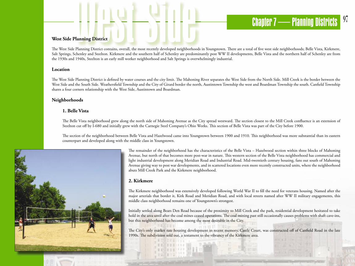
Th e Kirkmere neighborhood was extensively developed following World War II to fi ll the need for veterans housing. Named after the major arterials that border it, Kirk Road and Meridian Road, and with local streets named after WW II military engagements, this middle class neighborhood remains one of Youngstown’s strongest.
Initially settled along Bears Den Road because of the proximity to Mill Creek and the park, residential development hesitated to take hold in the area until after the coal mines ceased operations. Th e coal mining past still occasionally causes problems with shaft cave-ins, but this neighborhood has become among the most desirable in the City.
Th e City’s only market rate housing development in recent memory, Castle Court, was constructed off of Canfi eld Road in the late 1990s. Th e subdivision sold out, a testament to the vibrancy of the Kirkmere area.
Chapter 7 — Planning Districts98
3. Salt Springs
Salt Springs is a neighborhood with a mix of land uses. Th e residential section, just north of SR 711, was formerly part of the Steelton neighborhood, and the older mill housing between Salt Springs Road and the CSX rail line has suff ered because of its isolation. Th is area has scattered structures in various states of disrepair, vacant lots and a concentration of salvage yards. Th e other side of Salt Springs Road has newer multi-family dwellings between I-680 and the ravine that separates the residential areas from the industrial park.
Th e majority of the Salt Springs neighborhood was used as a slag dump to handle the waste products generated by the Ohio Works’ four blast furnaces. Yesterday’s waste products are today’s raw materials, and as slag became the preferred aggregate for asphalt paving, the slag piles were ‘mined’, the cleared land purchased by the City, and the whole dump area became a successful brownfi eld redevelopment project, the Salt Springs Industrial Park.
Th e residential sections were part of the City by 1910; the industrial park area was absorbed in 1929.
4. Schenley
Th e Schenley neighborhood mirrors many of the traits of its neighbor to the north, the Belle Vista neighborhood. Early development began along Mahoning Avenue and spread south. Like Belle Vista, the earliest settlement began at the Mill Creek/Mahoning confl uence. Th e section between Mill Creek and Belle Vista one block south of Mahoning was in the City by 1900, the rest of Schenley was part of the 1929 annexation.
Th e sections farthest west off of Mahoning have a mix of pre and post war middle class housing. Housing adjacent to Mill Creek Park is more substantial and exhibits a mix of historic and modern structures. Th e Mill Creek Park infl uence makes this the highest value housing in the Schenley neighborhood.
5. Steelton
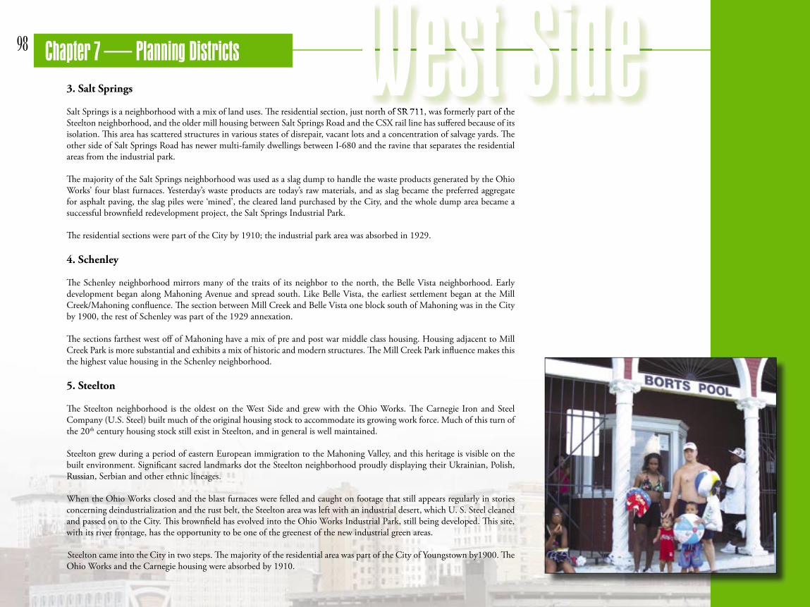
Th e Steelton neighborhood is the oldest on the West Side and grew with the Ohio Works. Th e Carnegie Iron and Steel Company (U.S. Steel) built much of the original housing stock to accommodate its growing work force. Much of this turn of the 20th century housing stock still exist in Steelton, and in general is well maintained.
Steelton grew during a period of eastern European immigration to the Mahoning Valley, and this heritage is visible on the built environment. Signifi cant sacred landmarks dot the Steelton neighborhood proudly displaying their Ukrainian, Polish, Russian, Serbian and other ethnic lineages.
When the Ohio Works closed and the blast furnaces were felled and caught on footage that still appears regularly in stories concerning deindustrialization and the rust belt, the Steelton area was left with an industrial desert, which U. S. Steel cleaned and passed on to the City. Th is brownfi eld has evolved into the Ohio Works Industrial Park, still being developed. Th is site, with its river frontage, has the opportunity to be one of the greenest of the new industrial green areas.
Steelton came into the City in two steps. Th e majority of the residential area was part of the City of Youngstown by1900. Th e Ohio Works and the Carnegie housing were absorbed by 1910.
Salt Springs is a neighborhood with a mix of land uses. Th e residential section, just north of SR 711, was formerly part of the

Chapter 7 — Planning Districts 99
Conditions
Population
Th e West Side of the City has been more stable than the other sides of town experiencing only an average of 7.75% population decline every ten years for the past 40 years.
Race
Th e racial make up the West Side of the City has remained predominately white over time.
Age
Th e majority of the population of the West Side is between 20 and 54 years old. 32.1% of the population is over the age of 55 years old and 23.8% are over the age of 65.
White Black Other

Chapter 7 — Planning Districts100
Housing, Vacant and Abandoned Properties
Chapter 4 chronicles what has been left behind by suburban fl ight and deindustrialization. Housing has been particularly impacted, as housing stock that once held in excess of 170,000 people now contains only 82,000 (see section 4.4 Housing). Excess housing is both a liability to existing neighborhoods and an opportunity to fi nd alternative uses for surplus residential land.
Over time many units have been removed from the City’s housing stock, but removal has lagged behind the rate of disinvestment and abandonment. Youngstown has been left with nearly 3,500 housing units in excess of what the current population can support. Th is agglomeration of economically nonviable housing induces further blight and abandonment. Patterns of blight and disinvestment are not geographically uniform.
Neighborhoods have been impacted dramatically diff erently. Th e West Side shows substantially less blight (see Map 56) than the North, South and East Sides. Population remains relatively densely settled along the Mahoning Avenue corridor and in the post WW II Belle Vista, Schenley and Kirkmere neighborhoods.
MAP 56

Chapter 7 — Planning Districts 101
Th e relatively light occurrence of blight is a mixed blessing. Where blight does show up is in the oldest West Side neighborhoods radiating off of Mahoning and along Canfi eld Road by Mill Creek Park. Experience on the other sides of town has shown that the older core neighborhoods are the fi rst to deteriorate and blight spreads swiftly from these seed areas.
Vacant land on the West Side (see Map 57) tends to exist along rail lines or in large undeveloped parcels. Th ere is some disinvestment in the old Steelton neighborhood. Maintaining the West Side is a major planning priority.
MAP 57

Chapter 7 — Planning Districts102
Current Land Use Plan
Current conditions in the West Side Planning District demonstrate a more modern look than the rest of the City. Still a creation of the 1951 and 1974 plans, the later development period meant that much of this district was able to take advantage of the suburban infl uences in the 1974 update without being overburdened with extensive pre 1951 development.
Th e current zoning (see Map 58) shows that south of the Mahoning Avenue commercial corridor, the West Side is predominantly residential. Th ere is also a vibrant commercial cluster at Cornersburg.
Th ere is substantial residential north of Mahoning, but with large industrial corridors, zoned for both heavy and light industry. Th e industrial zoning is a remnant of the past and an opportunity for the future.
MAP 58
Chapter 7 — Planning Districts 103
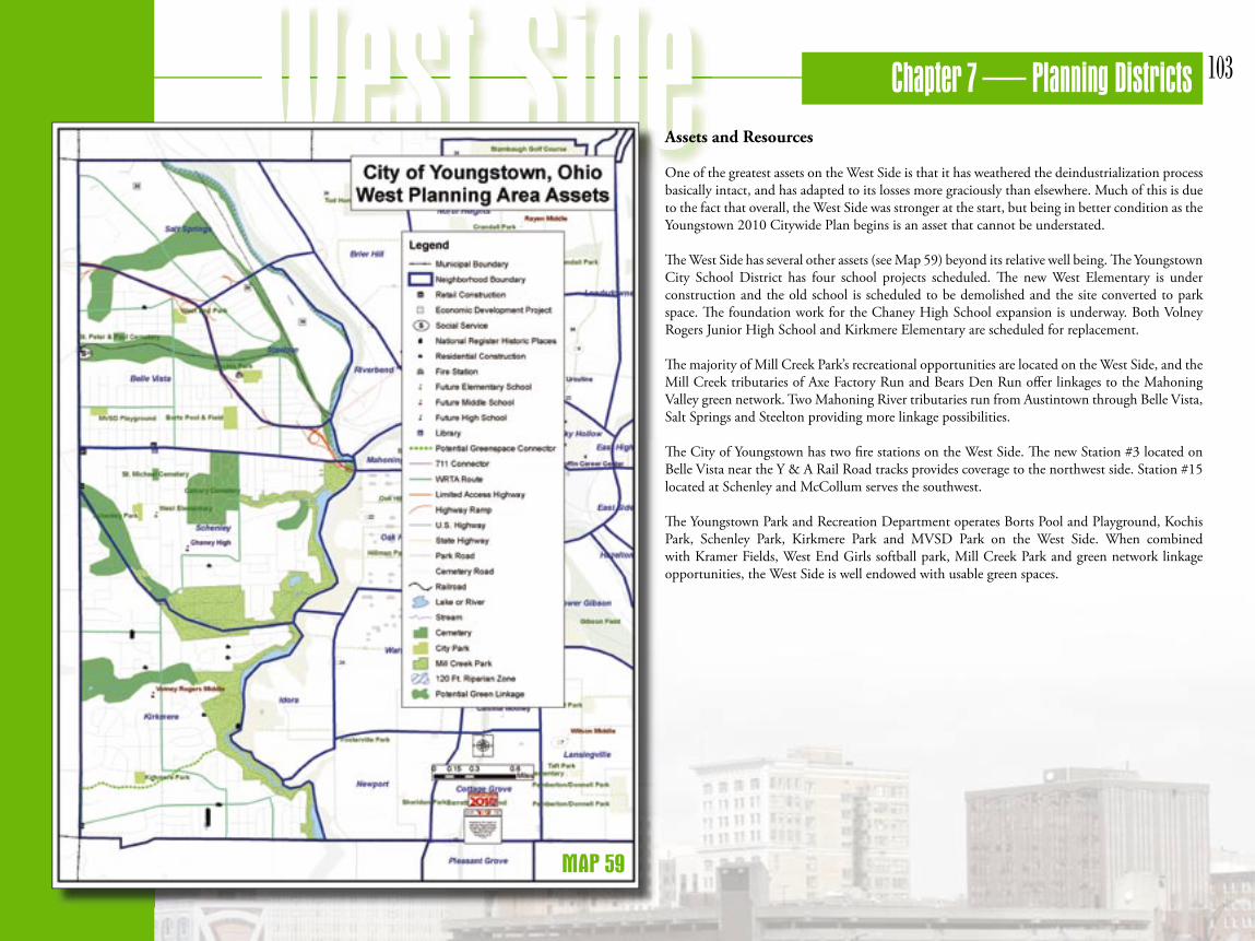
Assets and Resources
One of the greatest assets on the West Side is that it has weathered the deindustrialization process basically intact, and has adapted to its losses more graciously than elsewhere. Much of this is due to the fact that overall, the West Side was stronger at the start, but being in better condition as the Youngstown 2010 Citywide Plan begins is an asset that cannot be understated.
Th e West Side has several other assets (see Map 59) beyond its relative well being. Th e Youngstown City School District has four school projects scheduled. Th e new West Elementary is under construction and the old school is scheduled to be demolished and the site converted to park space. Th e foundation work for the Chaney High School expansion is underway. Both Volney Rogers Junior High School and Kirkmere Elementary are scheduled for replacement.
Th e majority of Mill Creek Park’s recreational opportunities are located on the West Side, and the Mill Creek tributaries of Axe Factory Run and Bears Den Run off er linkages to the Mahoning Valley green network. Two Mahoning River tributaries run from Austintown through Belle Vista, Salt Springs and Steelton providing more linkage possibilities.
Th e City of Youngstown has two fi re stations on the West Side. Th e new Station #3 located on Belle Vista near the Y & A Rail Road tracks provides coverage to the northwest side. Station #15 located at Schenley and McCollum serves the southwest.
Th e Youngstown Park and Recreation Department operates Borts Pool and Playground, Kochis Park, Schenley Park, Kirkmere Park and MVSD Park on the West Side. When combined with Kramer Fields, West End Girls softball park, Mill Creek Park and green network linkage opportunities, the West Side is well endowed with usable green spaces.
MAP 59
Chapter 7 — Planning Districts104
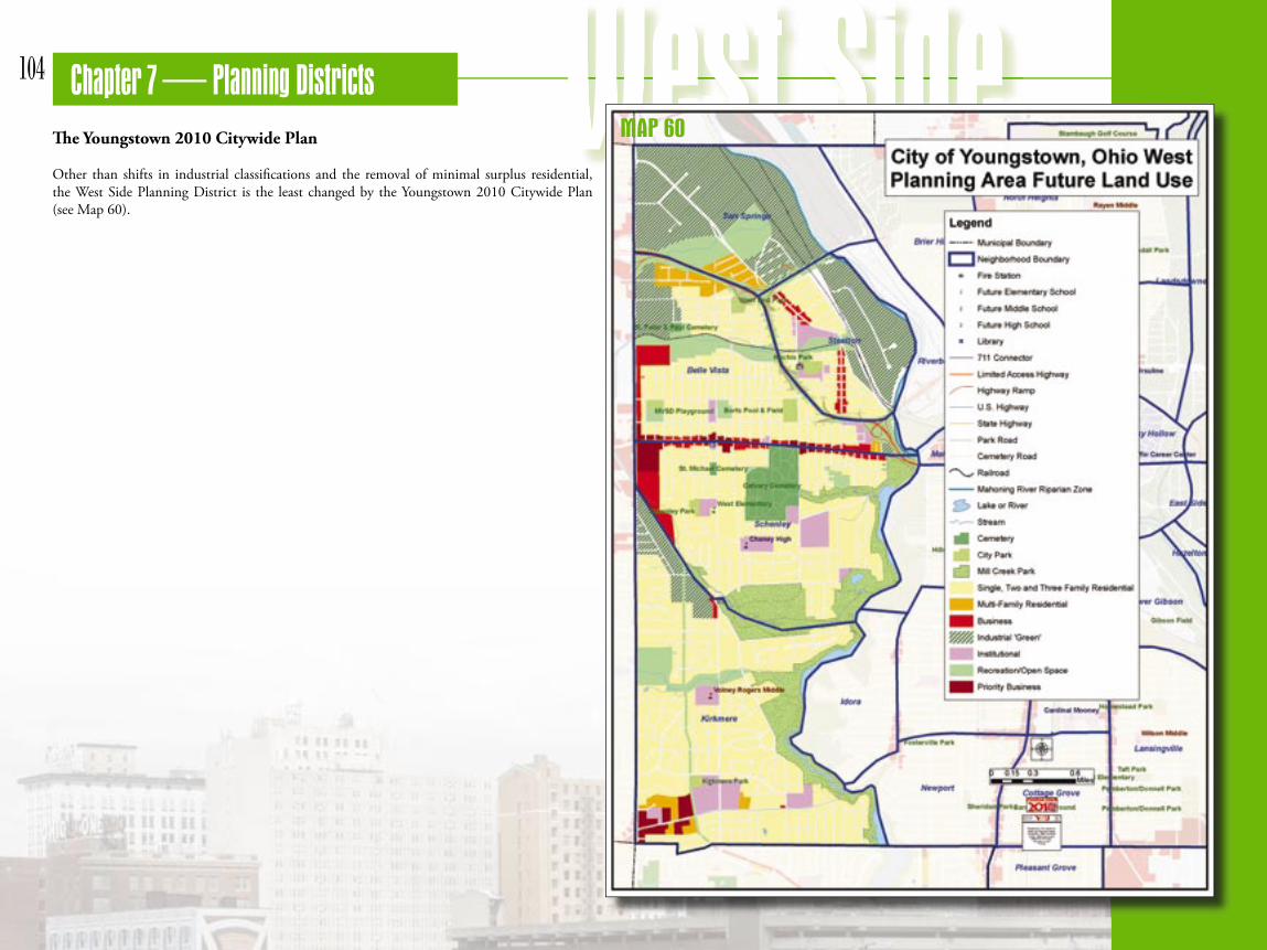
Th e Youngstown 2010 Citywide Plan
Other than shifts in industrial classifi cations and the removal of minimal surplus residential, the West Side Planning District is the least changed by the Youngstown 2010 Citywide Plan (see Map 60).
MAP 60

Chapter 7 — Planning Districts 105
Recreation and Open Space
Recreation and Open space is well distributed across the West Side Planning District (see Map 61). Th e presence of Mill Creek Park with its Frederick Olmstead designed Lakes Glacier and Cohasset, trails and stone bridges, the Fellows Riverside Gardens and Davis Visitor’s Center, the Wick and Kirkmere Recreation Areas and Pioneer Pavilion with its historic iron furnace give the West Side the direct advantage of the premier regional park.
Th e City’s Borts pool and playgrounds complement the Mill Creek advantage. Th e demolition of the old West Elementary School will yield a new green open space.
Other new open space recommendations for the West Side involve linkages to the Mahoning Valley Green Network. Th e Youngstown 2010 Citywide Plan recommends that hike and bike opportunities be established along the riparian zones of Axe Factory Run and Bears Den Run. Th ese will link Mill Creek and Austintown Township. Using the old rail road right-of-way that extends from Canfi eld Road to Industrial Road as a hike/bike trail will provide a north/south linkage across the stream trails.
Farther to the north, the open space along the Youngstown and Austintown rail road tracks provides another bike/hike opportunity that connects Austintown to the Ohio Works Industrial Park and the Mahoning River creating another regional green network linkage. Th e ravine, for the most part pristine, that divides the Salt Springs Industrial Park from the residential district already provides a park-like setting that could easily contain a hike/bike trail and other recreational opportunities once again connecting the West Side and Austintown to the regional network.
MAP 61

Chapter 7 — Planning Districts106
Residential
Th e Youngstown 2010 Citywide Plan proposes minimal changes to the existing residential land use on the West Side (see Map 62). Th e most notable of these is removing the truncated section of the old Salt Springs neighborhood east of Salt Springs Road and north of SR-711 from the residential use category. Th is area, which has already lost much of its housing stock and has scattered nonconforming commercial and industrial uses is being shifted to the new industrial green classifi cation.
Other sections being removed from residential land use are undeveloped areas along riparian zones or other green corridors that are being shifted to the recreation/open space use.
MAP 62

Chapter 7 — Planning Districts 107
Institutional
Th e amount of institutional land use on the West Side is being adjusted to match the current reality (see Map 63). Th e only institutional use in the existing zoning map was in the vicinity of Kirkmere Elementary School.
Th e Youngstown 2010 Citywide Plan reclassifi es the spacious church and school complexes scattered across the West Side as institutional. Some large undeveloped City owned properties also fell into this classifi cation.
MAP 63

Chapter 7 — Planning Districts108
Commercial
Th e amount of commercially classifi ed land on the West Side remains relatively constant (see Map 64). Th e goal was to make the amount and location of commercial use in the plan match existing reality and reasonable future expectations.
Th e existing retail strip along Steel Street and Salt Springs Road in Steelton is now offi cially classifi ed commercial. Th e small strip along Steel Street in the Belle Vista neighborhood has been reclassifi ed as residential. Th e north side of Industrial Road has been shifted from industrial light to commercial. Th e City side of Meridian Road from Mahoning to the rail road tracks is now completely commercial.
Th e Mahoning Avenue strip remains commercial, but key intersections have been bumped up to the priority business classifi cation. Th e priority business designation indicates locations where revitalization eff orts will be concentrated fi rst.
Priority locations along Mahoning Avenue are at Meridian, including the Mahoning Plaza, between Rhoda and Hazelwood, including the West Side Branch of the Public Library, and between Fernwood and Portland.
Other priority business clustered on the West Side are located in the Cornersburg area, one at Meridian/Tippecanoe and the other a disjointed extension of the fi rst farther east abutting the St. Christine complex.
MAP 64

109 Chapter 7 — Planning DistrictsIndustrial
Under the Youngstown 2010 Citywide Plan, there is no longer any heavy or light industrial classifi cation on the West Side. Th ere is in total more industrial land, but it is all in the new industrial green category (see Map 65). As was mentioned in the residential section, the truncated portion of the old Steelton neighborhood now in Salt Springs has been shifted to industrial green.
Th e Ohio Works Industrial Park had previously been classifi ed for heavy industrial use, but industry in the park meets green credentials. When the Mahoning River is cleaned, the riparian zone reestablished and landscaping takes place, the Ohio Works will join the City’s other industrial parks as premier brownfi eld reclamation projects.
Th e Salt Springs Road Industrial Park is moved from light industrial to industrial green because it meets the requirements. Th e former light industrial clusters at the I–680/Meridian Road exit and on the west side of Industrial Road are shifted for the same reason.
MAP 65