chapter 8. airport environs
TRANSCRIPT
8. Airport Environs
SANTA ROSA COUNTY - 373 -
Chapter 8. Airport Environs
CHAPTER EIGHT CONTENTS
8.01.00 GENERALLY 373
8.02.00 PUBLIC AIRPORT ZONES AND SURFACES 374
8.03.00 MILITARY AIRPORT ZONES AND SURFACES 382
8.04.00 DISCLOSURE 392
8.05.00 OUTDOOR LIGHTING STANDARDS AND GLARE CONTROL TO PROMOTE FLIGHT SAFETY 394
8.06.00 APPEALS 398
8.01.00 GENERALLY The Board of County Commissioners of Santa Rosa County has considered, among other things, the character of the operations conducted and proposed to be conducted at the various airports in the applicable areas of Santa Rosa County, the nature of the terrain and the character of the area within the airport hazard area; the current uses of property and the uses for which it is applicable, and the Board finds as follows:
A. There exist airports within Santa Rosa County and in proximity to Santa Rosa County whose operations are potentially inimical to the health, safety and general welfare of the citizens of Santa Rosa County;
B. Airport hazards endanger the lives and property of users of airports and occupants and owners of property in their vicinity;
C. Airports produce noise which is not compatible with residential uses and certain commercial and industrial uses;
D. Obstructions reduce the size of the area available for the landing, taking off and maneuvering of aircraft, thus tending to destroy or impair the utility of the airport and the public investment therein;
94
8. Airport Environs
SANTA ROSA COUNTY - 374 -
E. The creation or establishment of an airport hazard injures the community served by the airport in question; and
F. In the interest of the public health, safety and general welfare, the creation or establishment of airport hazards must be prevented.
8.01.01 Applicability The regulations on land use set forth herein are applicable to all lands within the delineated zones and surfaces set forth in this chapter. The delineated zones shall be an overlay district established and delineated on the adopted zoning maps.
8.01.02 Conflicting Regulations In the event of conflict between any regulations in this chapter and any other regulations applicable to the same property, the more stringent limitation or regulation shall govern and prevail.
8.02.00 PUBLIC AIRPORT ZONES AND SURFACES 8.02.01 Airport Zones and Surfaces The following definitions describe special zones or surfaces within, adjacent to or near a public airport. These special zones or surfaces are used to protect specific airspace areas or specific ground areas within the airport environ. All imaginary surfaces shall be consistent with the most recent applicable definitions set forth in Federal Air Regulations (FAR) Part 77 (Obstructions to Navigable Airspace).
A. Primary Surface: means an area longitudinally centered on a runway, extending 200 feet beyond each paved end. For Peter Prince Field, the Primary Surface is the areas within 200 linear feet from the edge of the runway end and a width of 500 feet.
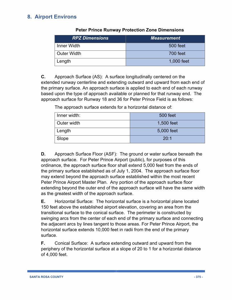
B. Runway Protection Zone (RPZ): The RPZ extends from each end of the primary surface to enhance the protection of people and property on the ground. The Runway Protection Zone is trapezoidal in shape and centered about the extended runway centerline. The RPZ dimension for a particular runway end is a function of the type of aircraft and the approach visibility minimum associated for that runway end. For Peter Prince Airport, the dimensions for the RPZ shall be that which is established within the most recent Peter Prince Airport Master Plan approved by the Board of County Commissioners. The dimensions for Peter Prince Airport’s Runway Protection Zone for runways 18 and 36 are as follows (and as illustrated below):
8. Airport Environs
SANTA ROSA COUNTY - 375 -
Peter Prince Runway Protection Zone Dimensions RPZ Dimensions Measurement
Inner Width 500 feet Outer Width 700 feet Length 1,000 feet
C. Approach Surface (AS): A surface longitudinally centered on the extended runway centerline and extending outward and upward from each end of the primary surface. An approach surface is applied to each end of each runway based upon the type of approach available or planned for that runway end. The approach surface for Runway 18 and 36 for Peter Prince Field is as follows:
The approach surface extends for a horizontal distance of:
Inner width: 500 feet Outer width 1,500 feet Length 5,000 feet Slope 20:1
D. Approach Surface Floor (ASF): The ground or water surface beneath the approach surface. For Peter Prince Airport (public), for purposes of this ordinance, the approach surface floor shall extend 5,000 feet from the ends of the primary surface established as of July 1, 2004. The approach surface floor may extend beyond the approach surface established within the most recent Peter Prince Airport Master Plan. Any portion of the approach surface floor extending beyond the outer end of the approach surface will have the same width as the greatest width of the approach surface.
E. Horizontal Surface: The horizontal surface is a horizontal plane located 150 feet above the established airport elevation, covering an area from the transitional surface to the conical surface. The perimeter is constructed by swinging arcs from the center of each end of the primary surface and connecting the adjacent arcs by lines tangent to those areas. For Peter Prince Airport, the horizontal surface extends 10,000 feet in radii from the end of the primary surface.
F. Conical Surface: A surface extending outward and upward from the periphery of the horizontal surface at a slope of 20 to 1 for a horizontal distance of 4,000 feet.
8. Airport Environs
SANTA ROSA COUNTY - 376 -
G. Conical Surface Floor (CSF): The ground or water surface beneath the conical surface.
H. Transitional Surface: Transitional surfaces extend outward and upward at right angles to the runway centerline and are extended at a slope of seven (7) feet horizontally for each foot vertically (7:1) from the sides of the primary and approach surfaces. The transitional surfaces extend to where they intercept the horizontal surface at a height of 150 feet above the runway elevation.
I. Public Airport Zone (PAZ): The Public Airport Zone is an overlay district that addresses land use compatibility with airport operations and structure height within the immediate airport vicinity most affected by take-off and landing patterns and airport ground activities. It covers an area extending one-half mile from the runway. The Public Airport Zone includes any portion of imaginary surfaces defined by Federal Aviation Regulations (FAR, Part 77) that lie within its half-mile perimeter. Serving principally to protect the airport from the encroachment of incompatible development, the Public Airport Zone also serves to protect health, safety, and quality of life for people living, working, or visiting the area most affected by airport activities.
J. Public Airport Influence Area (PAIA): The Public Airport Influence Area (PAIA) extends a distance of two miles from the runway centerline and contains those areas defined by Federal Aviation Regulations (FAR, Part 77) as imaginary surfaces. It serves principally to addresses land uses and structure heights that may create potential threat to flight safety and operation for aircraft approaching or departing an airport.
K. Public Airport Notification Zone: Public Airport Notification Zones are those areas within which notification of airfield proximity is required when property is sold or leased. The notification zone for Peter Prince is the same area as the Public Airport Zone.
8.02.02 Height Limitations within Public Airport Environs A building, structure, use or tree that penetrates any of the Federal Aviation Administration’s designated imaginary surfaces or zones constitutes an obstruction, as defined by Federal Air Regulations (FAR), Part 77. Height of buildings, structures, or trees within environs surrounding a public airport shall not create an unreasonable threat to aircraft operations and safety.
A. Any property or area located in more than one of the zones or surfaces described in this section shall be considered to be only in the zone or surface with the more restrictive height limitation.
B. Except as otherwise provided, no structure shall be constructed or maintained, or tree permitted to grow within any zone or surface created herein in excess of the height limitations established herein. In addition, no structure or
8. Airport Environs
SANTA ROSA COUNTY - 377 -
obstruction will be permitted within Santa Rosa County that could potentially change minimum obstruction clearance altitude, minimum descent altitude or a decision height.
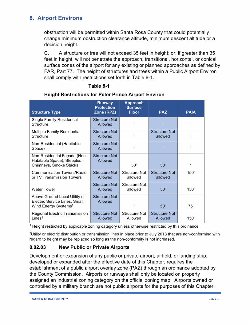
C. A structure or tree will not exceed 35 feet in height; or, if greater than 35 feet in height, will not penetrate the approach, transitional, horizontal, or conical surface zones of the airport for any existing or planned approaches as defined by FAR, Part 77. The height of structures and trees within a Public Airport Environ shall comply with restrictions set forth in Table 8-1.
Table 8-1 Height Restrictions for Peter Prince Airport Environ
Structure Type
Runway Protection Zone (RPZ)
Approach Surface
Floor PAZ PAIA
Single Family Residential Structure
Structure Not Allowed 1 1 1
Multiple Family Residential Structure
Structure Not Allowed 1
Structure Not allowed 1
Non-Residential (Habitable Space)
Structure Not Allowed 1 1 1
Non-Residential Façade (Non-Habitable Space), Steeples, Chimneys, Smoke Stacks
Structure Not Allowed
50’ 50’ 1
Communication Towers/Radio or TV Transmission Towers
Structure Not Allowed
Structure Not allowed
Structure Not allowed
150’
Water Tower Structure Not
Allowed Structure Not
allowed 50’ 150’
Above Ground Local Utility or Electric Service Lines, Small Wind Energy Systems2
Structure Not Allowed
1 50’ 75’
Regional Electric Transmission Lines2
Structure Not Allowed
Structure Not Allowed
Structure Not Allowed 150’
1 Height restricted by applicable zoning category unless otherwise restricted by this ordinance. 2Utility or electric distribution or transmission lines in place prior to July 2013 that are non-conforming with regard to height may be replaced so long as the non-conformity is not increased.
8.02.03 New Public or Private Airports
Development or expansion of any public or private airport, airfield, or landing strip, developed or expanded after the effective date of this Chapter, requires the establishment of a public airport overlay zone (PAZ) through an ordinance adopted by the County Commission. Airports or runways shall only be located on property assigned an Industrial zoning category on the official zoning map. Airports owned or controlled by a military branch are not public airports for the purposes of this Chapter.
8. Airport Environs
SANTA ROSA COUNTY - 378 -
All new public or private airports, heliports, or landing fields shall be designed so that the incidence of aircraft passing near preexisting dwellings or places of public assembly is minimized. New public or private airports shall be located in areas where air traffic will not expose residential uses to more than 55 decibel (day/night average) noise levels.
8.02.04 Use Restrictions Notwithstanding any provision of Chapter Two of this ordinance, the permitted land use for any property within a Public Airport Zone or Public Airport Influence Area shall be modified as set forth in Table 8-2.
A. Any property or area located in more than one of the zones or surfaces described in Section 8.02.00 shall be considered only in the zone or surface with the more restrictive or limited use.
B. Incompatible Uses or Activities: Uses or activities determined to be incompatible with airport operations, or contribute to a potential threat to flight safety, are prohibited within the designated zone or surface. An “N” appearing under a zone or surface category in Table 8-2 means that the use or activity is incompatible and not allowed.
C. Compatible Uses or Activities: Chapter Two provides generalized description of permitted uses and activities for each zoning category. Table 8-2 provides a more detail description of uses and activities that are determined to be compatible with airport operations and aircraft flight safety for public airports. A land use is a permissible use within an airport zone or imaginary surface category if such use is allowed within the underlying zoning category, as defined in Chapter Two, and if denoted as a compatible use within Table 8-2. A land use is compatible in an airport zone or imaginary surface if denoted by a “Y” in Table 8-2.
D. Conditional Uses or Activities: Certain land uses are incompatible with and prohibited within an airport environ zone or surface except when a development complies with conditions or specific development standards that create compatibility. Land uses denoted with a “C” in Table 8-2 are not allowed unless determined to be compliant with conditional use criteria set forth in Section 8.02.05.
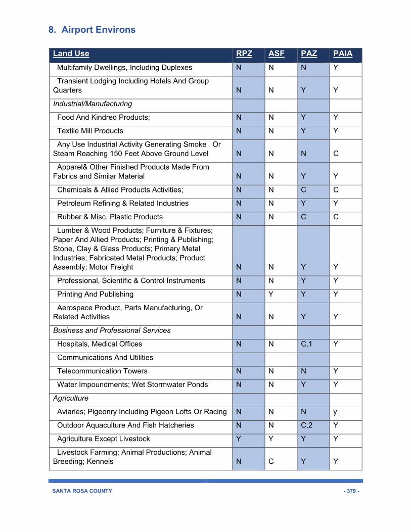
Table 8-2 Use Restrictions within Public Airport Environs Zones and Surfaces
Land Use RPZ ASF PAZ PAIA Residential
Single Family Dwelling N Y Y Y
8. Airport Environs
SANTA ROSA COUNTY - 379 -
Land Use RPZ ASF PAZ PAIA Multifamily Dwellings, Including Duplexes N N N Y
Transient Lodging Including Hotels And Group Quarters N N Y Y
Industrial/Manufacturing
Food And Kindred Products; N N Y Y
Textile Mill Products N N Y Y
Any Use Industrial Activity Generating Smoke Or Steam Reaching 150 Feet Above Ground Level N N N C
Apparel& Other Finished Products Made From Fabrics and Similar Material N N Y Y
Chemicals & Allied Products Activities; N N C C
Petroleum Refining & Related Industries N N Y Y
Rubber & Misc. Plastic Products N N C C
Lumber & Wood Products; Furniture & Fixtures; Paper And Allied Products; Printing & Publishing; Stone, Clay & Glass Products; Primary Metal Industries; Fabricated Metal Products; Product Assembly; Motor Freight N N Y Y
Professional, Scientific & Control Instruments N N Y Y
Printing And Publishing N Y Y Y
Aerospace Product, Parts Manufacturing, Or Related Activities N N Y Y
Business and Professional Services
Hospitals, Medical Offices N N C,1 Y
Communications And Utilities
Telecommunication Towers N N N Y
Water Impoundments; Wet Stormwater Ponds N N Y Y
Agriculture
Aviaries; Pigeonry Including Pigeon Lofts Or Racing N N N y
Outdoor Aquaculture And Fish Hatcheries N N C,2 Y
Agriculture Except Livestock Y Y Y Y
Livestock Farming; Animal Productions; Animal Breeding; Kennels N C Y Y
8. Airport Environs
SANTA ROSA COUNTY - 380 -
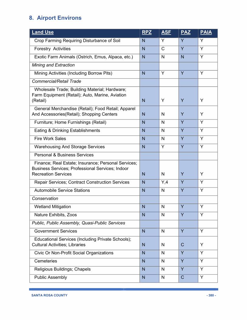
Land Use RPZ ASF PAZ PAIA Crop Farming Requiring Disturbance of Soil N Y Y Y
Forestry Activities N C Y Y
Exotic Farm Animals (Ostrich, Emus, Alpaca, etc.) N N N Y
Mining and Extraction
Mining Activities (Including Borrow Pits) N Y Y Y
Commercial/Retail Trade
Wholesale Trade; Building Material; Hardware; Farm Equipment (Retail); Auto, Marine, Aviation (Retail) N Y Y Y
General Merchandise (Retail); Food Retail; Apparel And Accessories(Retail); Shopping Centers N N Y Y
Furniture; Home Furnishings (Retail) N N Y Y
Eating & Drinking Establishments N N Y Y
Fire Work Sales N N Y Y
Warehousing And Storage Services N Y Y Y
Personal & Business Services
Finance; Real Estate; Insurance; Personal Services; Business Services; Professional Services; Indoor Recreation Services N N Y Y
Repair Services; Contract Construction Services N Y,4 Y Y
Automobile Service Stations N N Y Y
Conservation
Wetland Mitigation N N Y Y
Nature Exhibits, Zoos N N Y Y
Public, Public Assembly, Quasi-Public Services
Government Services N N Y Y
Educational Services (Including Private Schools); Cultural Activities; Libraries N N C Y
Civic Or Non-Profit Social Organizations N N Y Y
Cemeteries N N Y Y
Religious Buildings; Chapels N N Y Y
Public Assembly N N C Y
8. Airport Environs
SANTA ROSA COUNTY - 381 -
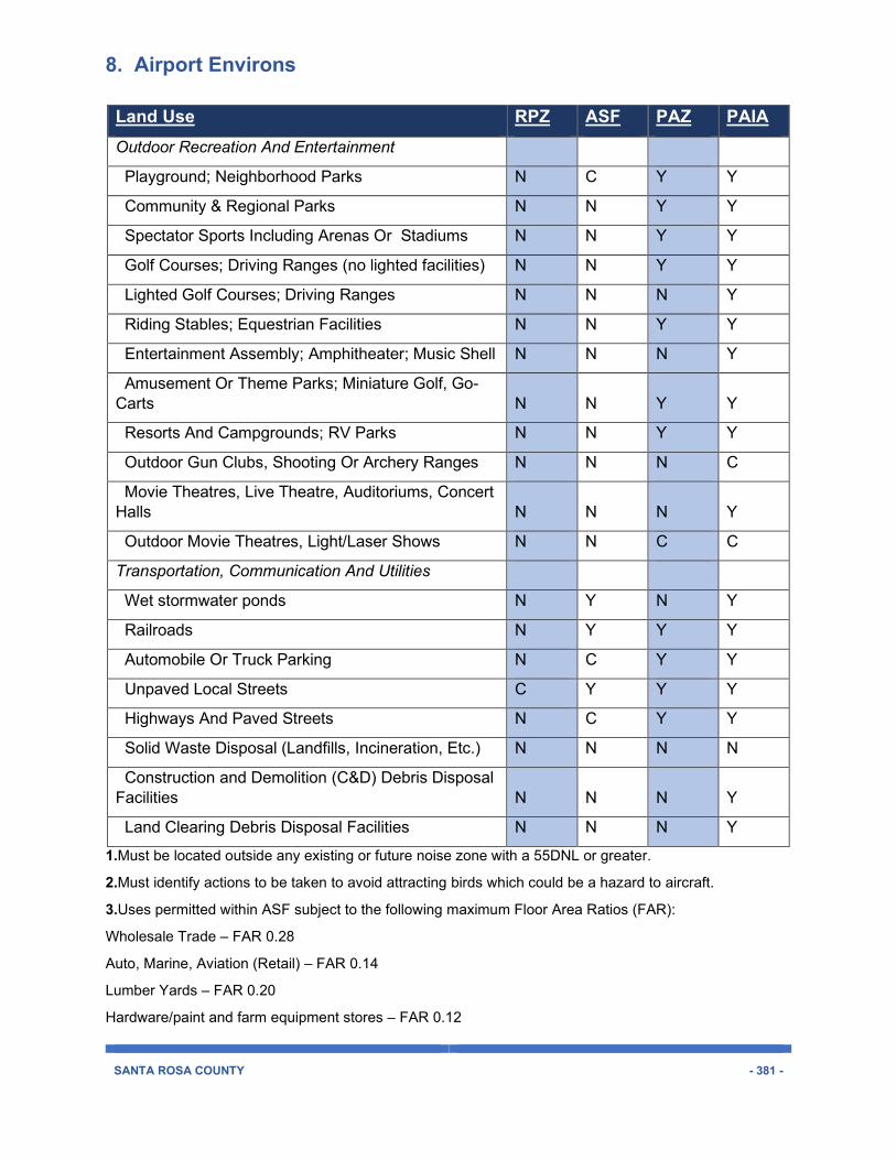
Land Use RPZ ASF PAZ PAIA Outdoor Recreation And Entertainment
Playground; Neighborhood Parks N C Y Y
Community & Regional Parks N N Y Y
Spectator Sports Including Arenas Or Stadiums N N Y Y
Golf Courses; Driving Ranges (no lighted facilities) N N Y Y
Lighted Golf Courses; Driving Ranges N N N Y
Riding Stables; Equestrian Facilities N N Y Y
Entertainment Assembly; Amphitheater; Music Shell N N N Y
Amusement Or Theme Parks; Miniature Golf, Go-Carts N N Y Y
Resorts And Campgrounds; RV Parks N N Y Y
Outdoor Gun Clubs, Shooting Or Archery Ranges N N N C
Movie Theatres, Live Theatre, Auditoriums, Concert Halls N N N Y
Outdoor Movie Theatres, Light/Laser Shows N N C C
Transportation, Communication And Utilities
Wet stormwater ponds N Y N Y
Railroads N Y Y Y
Automobile Or Truck Parking N C Y Y
Unpaved Local Streets C Y Y Y
Highways And Paved Streets N C Y Y
Solid Waste Disposal (Landfills, Incineration, Etc.) N N N N
Construction and Demolition (C&D) Debris Disposal Facilities N N N Y
Land Clearing Debris Disposal Facilities N N N Y
1.Must be located outside any existing or future noise zone with a 55DNL or greater.
2.Must identify actions to be taken to avoid attracting birds which could be a hazard to aircraft.
3.Uses permitted within ASF subject to the following maximum Floor Area Ratios (FAR):
Wholesale Trade – FAR 0.28
Auto, Marine, Aviation (Retail) – FAR 0.14
Lumber Yards – FAR 0.20
Hardware/paint and farm equipment stores – FAR 0.12
8. Airport Environs
SANTA ROSA COUNTY - 382 -
4.Uses permitted within ASF subject to the following maximum Floor Area Ratios (FAR):
FAR 0.11
Abbreviations/Acronyms Associated with Table 8-2 RPZ – runway protection zone for public airfield
ASF – approach surface floor
PAZ – public airport zone
PAIA – public airport influence area
C – conditional use
N – Use located in a zone or surface is incompatible with airport activities and
Is prohibited.
Y – Use is compatible within the zone or surface indicated.
8.02.05 Conditional Use Criteria This subsection section is used in conjunctions with Table 8-2 for the purposes of placing regulatory conditions on proposed development or uses to establish land use compatibility with public airport operations. This criteria is to be applied to those land uses denoted under a zone or surface as a conditional use.
A. The site size, dimensions, location, topography and access are adequate for the needs of the proposed use, considering the proposed building mass, parking, and traffic as well as noise, vibration, odor or dust generated by airport activities.
B. The negative impacts of the proposed use on aircraft flight safety and on the use of airport facilities can be mitigated through application of other Code standards, or other reasonable conditions of approval. A property owner demonstrates that exhaust, emissions, light, glare, or dust will not reduce the effective use of the airport or increase risk for hazards or accidents within the Public Airport Zone.
C. All required public facilities have adequate capacity to serve the proposal.
8.03.00 MILITARY AIRPORT ZONES AND SURFACES 8.03.01 Airport Zones and Surfaces The following definitions describe special zones within, adjacent to or near a military airport. These special zones are used to protect specific airspace areas or specific ground areas within the military airport environ.
8. Airport Environs
SANTA ROSA COUNTY - 383 -
A. Accident Potential Zone 1: Accident Potential Zone (APZ) 1 is an area beyond the clear zone that exhibits a measurable potential for accidents relative to the clear zone. The APZ may curve to follow flight tracks.
B. Accident Potential Zone 2: APZ 2 is an area beyond APZ 1 that exhibits a measurable potential for aircraft accidents relative to APZ 1 or the clear zone. The APZ may curve to follow flight tracks.
C. Approach Surface: The area longitudinally centered on each runway centerline, with an inner boundary 200 feet from the end of the runway and the same width as the primary surface then extending outward for a distance of 50,000 feet expanding uniformly in width to 16,000 feet at the outer boundary. Height limits within the approach surface commence at the height of the runway end and increases at the rate of one foot vertically for every 50 feet horizontally for a distance of 25,000 feet at which point it remains level at 500 feet above airport elevation to the outer boundary.
D. Clear Zone: The clear zone is an area immediately beyond the end of a runway and exhibits the greatest potential for occurrence of aircraft accidents.
E. Conical Surface: A surface extending from the periphery of the inner horizontal surface outward and upward at a slope of 20:1 for a horizontal distance of 7,000 feet to a height of 500 feet above the established airfield clearance.
F. Inner-Horizontal Surface: The area encompassing the runway, primary surface and clear zone with an outer perimeter formed by swinging arcs from the end of each runway centerline and connecting adjacent arcs by lines tangent to these arcs. The radius of the arcs are 7,500 feet. No structure or obstruction will be permitted in the inner-horizontal surface of a greater height than 150 feet above airport elevation.
G. Military Airport Zone (MAZ): The Military Airport Zone (MAZ) is an overlay district providing regulatory measures and zoning standards to achieve land use compatibility and protection of public health and safety in the areas exposed to impacts generated by military flight or ground activities occurring at, near, or above military airports.
For Naval Air Station Whiting Field North and South, and for Naval Outlying Landing Fields Spencer, Harold, Santa Rosa, Site X, and Pace, the MAZ boundaries extend one half mile from the perimeter of each airfield and encompass all Air Installation Compatible Use Zones (AICUZ) and noise zones. For NOLF Choctaw, MAZ boundaries are as depicted on the attached map which is incorporated as part of the MAZ overlay to the Zoning Map.
8. Airport Environs
SANTA ROSA COUNTY - 384 -
For Eglin Air Force Base, the MAZ (EAFB MAZ) boundary is as depicted on the attached map which is incorporated as part of the MAZ overlay to the Zoning Map.
H. Military Airport Influence Area (MAIA): An MAIA extends two miles from a runway. It serves principally to addresses land uses and structure heights that may create potential threat to flight safety and operation for aircraft approaching or departing an airport or within a local flight pattern.
I. Military Airport Notification Zone: Military Airport Notification Zones are those areas within which notification of airfield proximity is required when property is sold or leased. For Naval Air Station Whiting Field North and South, the notification zone boundaries extend one mile from the perimeter of each airfield. For Naval Outlying Fields Spencer, Harold, Santa Rosa, Site X and Pace, the notification zone boundaries extend one half mile from the perimeter of each airfield. For NOLF Choctaw, the notification zone boundaries encompass that area are as depicted on the attached map which is incorporated as part of the Notification Zones overlay to the Zoning Map. For Eglin Air Force Base, the notification zone boundaries encompass the EAFB MAZ and that area bounded by the East Bay River on the north; the Okaloosa County Lone on the east; Santa Rosa Sound on the south; and the western boundary of sections 8, 16, and 21- in township 2 South and range 26 west, and a line approximately 540 feet north of and parallel to the southern boundary of section 8 in township 2 South and range 26 west on the west.
J. Noise Contour: A line connecting points of similar day-night average sound levels measured from a specific noise source.
K. Outer-Horizontal Surface: The area extending outward from the outer periphery of the conical surface is 500 feet above airport elevation.
L. Primary Surface: An area longitudinally centered on each runway and extending 200 feet beyond the runway end. The width of the primary surface varies for the type of aircraft accommodated as follows:
1. Jets and large turbo-prop aircraft - 1,500 feet.
2. Prop and small turbo-prop aircraft - 1,000 feet.
M. Transitional Surface: The area with an inner boundary formed by the side of the primary surface and the approach surface then extending outward at a right angle to the runway centerline and extended centerline until the height matches the adjoining inner horizontal surface, conical surface and outer horizontal surface height limit. The height limit at the inner boundary is the same as the height limit of the adjoining surface and increases at the rate of one foot vertically for every seven feet horizontally to the outer boundary of the transitional surface, where it again matches the height of the adjoining surface.
8. Airport Environs
SANTA ROSA COUNTY - 385 -
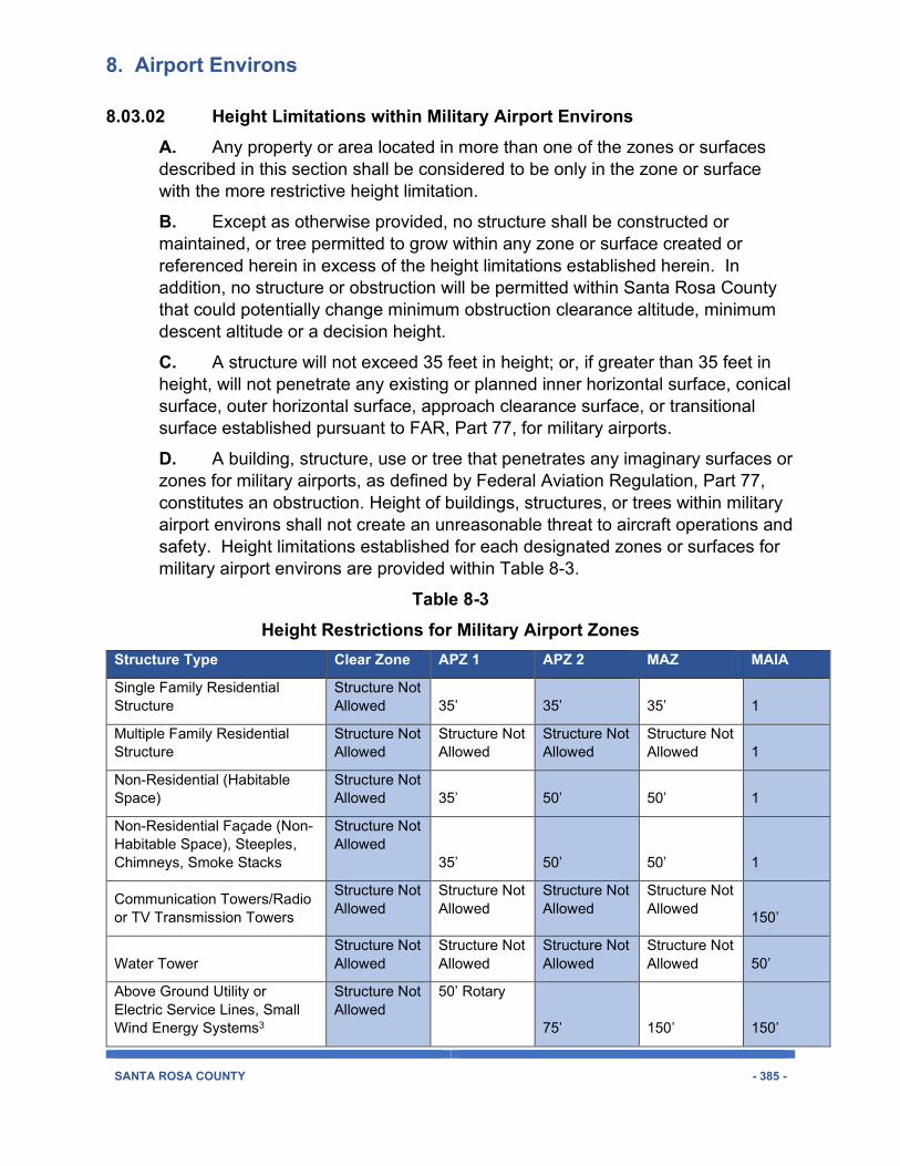
8.03.02 Height Limitations within Military Airport Environs A. Any property or area located in more than one of the zones or surfaces described in this section shall be considered to be only in the zone or surface with the more restrictive height limitation.
B. Except as otherwise provided, no structure shall be constructed or maintained, or tree permitted to grow within any zone or surface created or referenced herein in excess of the height limitations established herein. In addition, no structure or obstruction will be permitted within Santa Rosa County that could potentially change minimum obstruction clearance altitude, minimum descent altitude or a decision height.
C. A structure will not exceed 35 feet in height; or, if greater than 35 feet in height, will not penetrate any existing or planned inner horizontal surface, conical surface, outer horizontal surface, approach clearance surface, or transitional surface established pursuant to FAR, Part 77, for military airports.
D. A building, structure, use or tree that penetrates any imaginary surfaces or zones for military airports, as defined by Federal Aviation Regulation, Part 77, constitutes an obstruction. Height of buildings, structures, or trees within military airport environs shall not create an unreasonable threat to aircraft operations and safety. Height limitations established for each designated zones or surfaces for military airport environs are provided within Table 8-3.
Table 8-3 Height Restrictions for Military Airport Zones
Structure Type Clear Zone APZ 1 APZ 2 MAZ MAIA
Single Family Residential Structure
Structure Not Allowed 35’ 35’ 35’ 1
Multiple Family Residential Structure
Structure Not Allowed
Structure Not Allowed
Structure Not Allowed
Structure Not Allowed 1
Non-Residential (Habitable Space)
Structure Not Allowed 35’ 50’ 50’ 1
Non-Residential Façade (Non-Habitable Space), Steeples, Chimneys, Smoke Stacks
Structure Not Allowed
35’ 50’ 50’ 1
Communication Towers/Radio or TV Transmission Towers
Structure Not Allowed
Structure Not Allowed
Structure Not Allowed
Structure Not Allowed
150’
Water Tower Structure Not Allowed
Structure Not Allowed
Structure Not Allowed
Structure Not Allowed 50’
Above Ground Utility or Electric Service Lines, Small Wind Energy Systems3
Structure Not Allowed
50’ Rotary
75’ 150’ 150’
8. Airport Environs
SANTA ROSA COUNTY - 386 -
75’ Fixed Wing 2
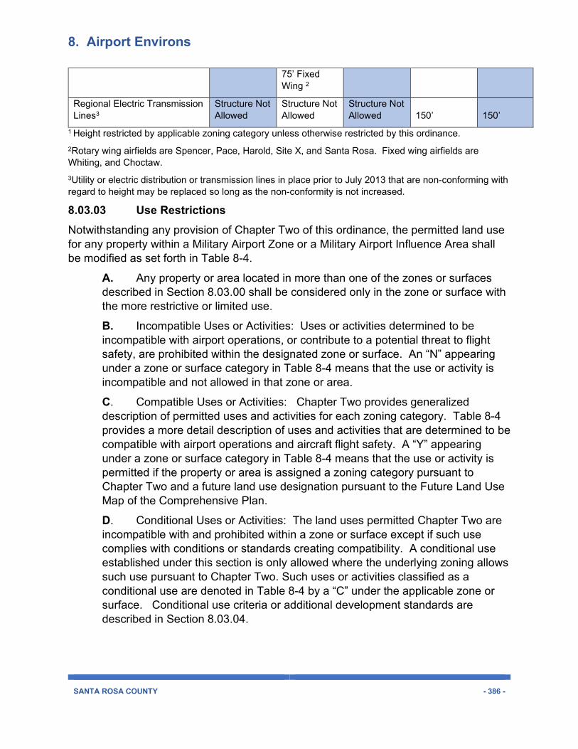
Regional Electric Transmission Lines3
Structure Not Allowed
Structure Not Allowed
Structure Not Allowed 150’ 150’
1 Height restricted by applicable zoning category unless otherwise restricted by this ordinance. 2Rotary wing airfields are Spencer, Pace, Harold, Site X, and Santa Rosa. Fixed wing airfields are Whiting, and Choctaw. 3Utility or electric distribution or transmission lines in place prior to July 2013 that are non-conforming with regard to height may be replaced so long as the non-conformity is not increased.
8.03.03 Use Restrictions
Notwithstanding any provision of Chapter Two of this ordinance, the permitted land use for any property within a Military Airport Zone or a Military Airport Influence Area shall be modified as set forth in Table 8-4.
A. Any property or area located in more than one of the zones or surfaces described in Section 8.03.00 shall be considered only in the zone or surface with the more restrictive or limited use.
B. Incompatible Uses or Activities: Uses or activities determined to be incompatible with airport operations, or contribute to a potential threat to flight safety, are prohibited within the designated zone or surface. An “N” appearing under a zone or surface category in Table 8-4 means that the use or activity is incompatible and not allowed in that zone or area.
C. Compatible Uses or Activities: Chapter Two provides generalized description of permitted uses and activities for each zoning category. Table 8-4 provides a more detail description of uses and activities that are determined to be compatible with airport operations and aircraft flight safety. A “Y” appearing under a zone or surface category in Table 8-4 means that the use or activity is permitted if the property or area is assigned a zoning category pursuant to Chapter Two and a future land use designation pursuant to the Future Land Use Map of the Comprehensive Plan.
D. Conditional Uses or Activities: The land uses permitted Chapter Two are incompatible with and prohibited within a zone or surface except if such use complies with conditions or standards creating compatibility. A conditional use established under this section is only allowed where the underlying zoning allows such use pursuant to Chapter Two. Such uses or activities classified as a conditional use are denoted in Table 8-4 by a “C” under the applicable zone or surface. Conditional use criteria or additional development standards are described in Section 8.03.04.
8. Airport Environs
SANTA ROSA COUNTY - 387 -
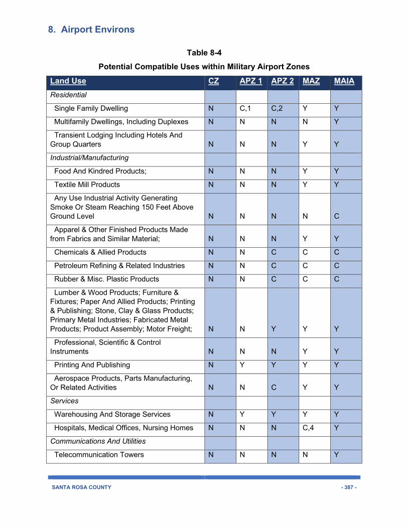
Table 8-4 Potential Compatible Uses within Military Airport Zones
Land Use CZ APZ 1 APZ 2 MAZ MAIA Residential
Single Family Dwelling N C,1 C,2 Y Y
Multifamily Dwellings, Including Duplexes N N N N Y
Transient Lodging Including Hotels And Group Quarters N N N Y Y
Industrial/Manufacturing
Food And Kindred Products; N N N Y Y
Textile Mill Products N N N Y Y
Any Use Industrial Activity Generating Smoke Or Steam Reaching 150 Feet Above Ground Level N N N N C
Apparel & Other Finished Products Made from Fabrics and Similar Material; N N N Y Y
Chemicals & Allied Products N N C C C
Petroleum Refining & Related Industries N N C C C
Rubber & Misc. Plastic Products N N C C C
Lumber & Wood Products; Furniture & Fixtures; Paper And Allied Products; Printing & Publishing; Stone, Clay & Glass Products; Primary Metal Industries; Fabricated Metal Products; Product Assembly; Motor Freight; N N Y Y Y
Professional, Scientific & Control Instruments N N N Y Y
Printing And Publishing N Y Y Y Y
Aerospace Products, Parts Manufacturing, Or Related Activities N N C Y Y
Services
Warehousing And Storage Services N Y Y Y Y
Hospitals, Medical Offices, Nursing Homes N N N C,4 Y
Communications And Utilities
Telecommunication Towers N N N N Y
8. Airport Environs
SANTA ROSA COUNTY - 388 -
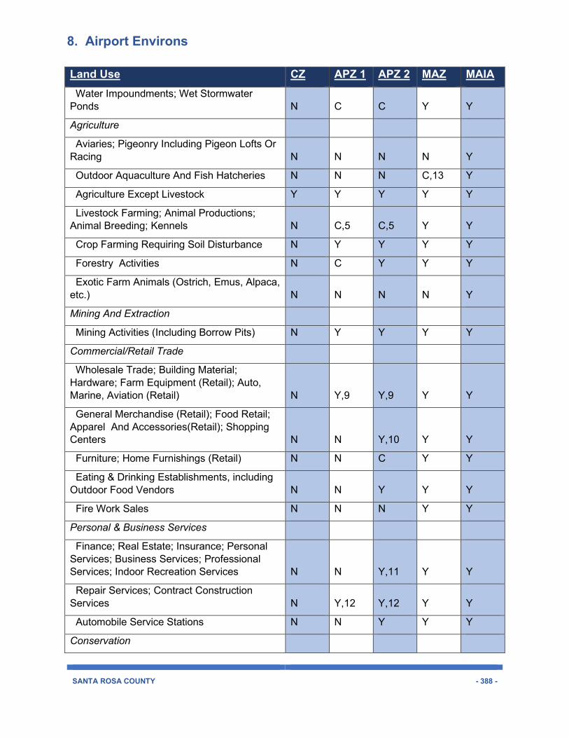
Land Use CZ APZ 1 APZ 2 MAZ MAIA Water Impoundments; Wet Stormwater Ponds N C C Y Y
Agriculture
Aviaries; Pigeonry Including Pigeon Lofts Or Racing N N N N Y
Outdoor Aquaculture And Fish Hatcheries N N N C,13 Y
Agriculture Except Livestock Y Y Y Y Y
Livestock Farming; Animal Productions; Animal Breeding; Kennels N C,5 C,5 Y Y
Crop Farming Requiring Soil Disturbance N Y Y Y Y
Forestry Activities N C Y Y Y
Exotic Farm Animals (Ostrich, Emus, Alpaca, etc.) N N N N Y
Mining And Extraction
Mining Activities (Including Borrow Pits) N Y Y Y Y
Commercial/Retail Trade
Wholesale Trade; Building Material; Hardware; Farm Equipment (Retail); Auto, Marine, Aviation (Retail) N Y,9 Y,9 Y Y
General Merchandise (Retail); Food Retail; Apparel And Accessories(Retail); Shopping Centers N N Y,10 Y Y
Furniture; Home Furnishings (Retail) N N C Y Y
Eating & Drinking Establishments, including Outdoor Food Vendors N N Y Y Y
Fire Work Sales N N N Y Y
Personal & Business Services
Finance; Real Estate; Insurance; Personal Services; Business Services; Professional Services; Indoor Recreation Services N N Y,11 Y Y
Repair Services; Contract Construction Services N Y,12 Y,12 Y Y
Automobile Service Stations N N Y Y Y
Conservation
8. Airport Environs
SANTA ROSA COUNTY - 389 -
Land Use CZ APZ 1 APZ 2 MAZ MAIA Wetland Mitigation N N N Y Y
Nature Exhibits, Zoos N N N Y Y
Public, Public Assembly, Quasi-Public Services
Government Services N N N Y Y
Educational Services (Including Private Schools); Cultural Activities; Libraries N N N C Y
Civic Or Non-Profit Social Organizations N N Y Y Y
Cemeteries N Y Y Y Y
Religious Buildings; Chapels N N N Y Y
Public Assembly N N N N Y
Outdoor Recreation And Entertainment
Playground; Neighborhood Parks N C C Y Y
Community & Regional Parks N N N Y Y
Spectator Sports Including Arenas Or Stadiums N N N Y Y
Golf Courses; Driving Ranges (no lighted facilities allowed) N N Y Y Y
Lighted Golf Courses; Driving Ranges N N N N Y
Riding Stables; Equestrian Facilities N N N Y Y
Entertainment Assembly; Amphitheater; Music Shell N N N N Y
Amusement Or Theme Parks; Miniature Golf, Go-Carts N N Y Y Y
Resorts And Campgrounds; RV Parks N N N Y Y
Outdoor Gun Clubs, Shooting Or Archery Ranges N N N N C
Movie Theatres, Live Theatre, Auditoriums, Concert Halls N N N N Y
Outdoor Movie Theatres, Light/Laser Shows N N N N C
Transportation, Communication And Utilities
Wet stormwater ponds N N N N Y
Railroads N Y Y Y Y
8. Airport Environs
SANTA ROSA COUNTY - 390 -
Land Use CZ APZ 1 APZ 2 MAZ MAIA Automobile Or Truck Parking N C Y Y Y
Unpaved Local Streets C Y Y Y Y
Highways And Paved Streets N C Y Y Y
Solid Waste Disposal (Landfills, Incineration, Etc.) N N N N N
Construction and Demolition (C&D) Debris Disposal Facilities N N N N,8 Y
Land Clearing Debris Disposal Facilities N N N N,8 Y
1.Density limited to one unit per five acres. Subdivision design and building location may be subject to Chapter Four.
2.Density not to exceed two units per one acre or existing zoning density, whichever is less. Subdivision design and building location may be subject to Chapter Four.
3.No more than four units per individual building.
4.Must be located outside any existing or future noise zone with a 55 DNL or greater.
5.Grazing allowed but feedlots and intensive stock yards are prohibited.
6.Left Blank Intentionally.
7.Left Blank Intentionally.
8.C&D and LCD disposal facilities may be allowed with rezoning approval within that portion of the NOLF Choctaw MAZ located east of Highway 87S.
9.Uses permitted within APZ-1 and APZ-2 subject to the following maximum Floor Area Ratios
Wholesale Trade – FAR 0.28 in APZ-1 and 0.56 in APZ-2
Auto, Marine, Aviation (Retail) – FAR of 0.14 in APZ-1 and 0.28 in APZ-2
Lumber Yards – FAR 0.20 in APZ-1 and 0.40 in APZ-2
Hardware/paint and farm equipment stores – FAR 0.12 in APZ-1 and 0.24 in APZ-2
10. Uses permitted within APZ-2 with a maximum FAR of 0.16
11. Uses permitted within AP-2 with a maximum FAR of 0.22
12. Uses permitted with APZ-1 and APZ-2 subject to the following maximum Floor Area Rations FAR 0.11 in APZ-1 and 0.22 in APZ-2
13. Must identify actions to be taken to avoid the concentration of birds which would create a hazard to aircraft operations.
Abbreviations/Acronyms for Table 11-4 CZ – clear zone for a military airport or airfield
APZ1 – accident potential zone category one
APZ2 – accident potential zone category two
8. Airport Environs
SANTA ROSA COUNTY - 391 -
MAIA – Military Airport Influence Area
8.03.04 Conditional Use Criteria This section is to be used with Table 8-4 for the purposes of placing regulatory conditions on proposed development or uses to establish land use compatibility with military airport operations. This criteria is to be applied to those land uses denoted under a zone or surface as a conditional use
A. The site size, dimensions, location, topography and access are adequate for the needs of the proposed use, considering the proposed building mass, parking, and traffic as well as noise, vibration, odor or dust generated by military airport or ground activities.
B. Noise, vibration, odor or dust generated by military airport or ground activities can be mitigated through application of other Code standards, or other reasonable conditions of approval.
C. The negative impacts of the proposed use on aircraft flight safety and on the use of airport facilities can be mitigated through application of other Code standards, or other reasonable conditions of approval. A property owner demonstrates that exhaust, emissions, light, glare, dust will not reduce the effective use of the airport or increase risk for hazards or accidents within the Public Airport Zone.
D. All required public facilities have adequate capacity to serve the proposal.
E. The use is not located underneath the normal entry or departure flight track within the MAZ.
8.03.05 Navy Outlying Field Spencer Within zone B1 for OLF Spencer, one single family dwelling may be constructed on a lot which was of record or subject to a written contract for purchase as of September 1, 2002, despite the fact that it does not conform with the minimum lot requirements set forth in Table 8-4, providing that all other applicable regulations and ordinances are complied with. The location of any single family home constructed on such non-conforming lot shall be reviewed and approved by the Planning and Zoning Department so as to minimize airport hazards.
8.03.06 Non-Conforming Uses Limitations which restrict non-conforming uses and/or non-complying buildings and structures in order to realize the legislative intent and purpose of this ordinance and the adopted Comprehensive Plan of Santa Rosa County shall adhere to and follow procedures and standards set forth in Chapter Nine.
8. Airport Environs
SANTA ROSA COUNTY - 392 -
8.03.07 Permits No new structure or use may be constructed or established or any existing use or structure substantially changed or altered or repaired within a Military Airport Zone or Public Airport Zone unless a permit has been granted by the Building Inspection Department. Each application for a permit shall indicate the purpose for which the permit is desired with sufficient particularity to permit a determination as to whether the resulting use, structure or growth would conform to the regulations herein prescribed. If the determination is affirmative, the permit shall be granted. No permit shall be granted that would allow the creation of an airport hazard.
8.04.00 DISCLOSURE 8.04.01 Disclosure No person shall sell, lease, nor offer for sale or lease any property within a Military Airport Notification Zone or Public Airport Notification Zone unless the prospective buyer or lessee has been duly notified through one or more of the following requirements.
A. Disclosure with Sale or Lease Contract
1. Sale of Residential Property. Any contract for the sale of residential property that is located in whole or part within a Public Airport Notification Zone or a Military Airport Notification Zone, shall include, as an attachment to the contract of sale, a Military or Public Airport Disclosure Notice, in a form approved by Santa Rosa County. The Military or Public Airport Disclosure Notice shall be dated and signed by the purchaser(s) and the seller(s). If the seller is represented by a real estate agent, the agent shall witness the signature(s) of the seller(s). The seller is responsible for providing a copy of the signed Disclosure Notice to the NAS Whiting Field Aviation Planning Office A disclosure notice form will be made available by the Planning and Zoning Department.
2. Lease of Residential Property. Any contract for the lease of a residential dwelling for more than seven months shall be subject to the notification requirements set forth in Subsection A.1.
3. Consumer Protection. The failure of a sales contract to comply with the requirements of Subsection A.1. shall enable a party to the contract who is aggrieved by such failure to rescind the contract any time prior to settlement. The failure of a lease contract to comply with the requirements of Subsection A.2. shall enable a party who is aggrieved by such failure to rescind the contract any time prior to the contract termination date. The right of rescission provided by this Subsection is not an exclusive remedy, and any other right or cause of action available to a party to the sales or lease contract shall remain.
8. Airport Environs
SANTA ROSA COUNTY - 393 -
B. Realty Sales Offices and Marketing. Sales offices used to market or sell new residential homes or mobile homes, including pre-construction sales, which will be constructed on lots located in a Military Airport Notification Zone or a Public Airport Notification Zone, must display a map illustrating public airport or military installation property boundaries, accident potential zones, clear zones, runway protection zones, and noise zones (55 decibel). This display requirement also applies to temporary reality sales offices. Pamphlets illustrating the same information appearing the on paper not less than 8.5” by 11” shall also be made available and placed in public view.
1. Display Requirements. The map shall be no smaller than 24 inches by 36 inches and must be prominently displayed in a public area of the office and copies of such map must be available on paper which is 8 ½ by 11 inches or larger in dimension. The display and pamphlet must include a statement that additional information regarding Military Airport Zones, Public Airport Zones and zoning is available at the Santa Rosa County Planning and Zoning Department and include its most current telephone number. The location of the residential development shall be denoted on the map or pamphlet.
2. Temporary Permits. A temporary permit shall not be issued for a realty sales office located in Santa Rosa County unless it contains a requirement for compliance with Subsections B.1. and B.4.
3. Site Plan Permits. A site plan approval for any commercial or office use within Santa Rosa County shall include a statement that any reality sales office use shall comply with the display requirements of this Section.
4. Marketing Brochures. Any real estate office or business within Santa Rosa County that produces a marketing brochure for residential home sales or rental units located on property wholly or partially within a Military Airport Notification Zone or Public Airport Notification Zone shall include in said brochure the following statement:
“Some or all of the property within this residential development lies within a Military Airport Notification Zone or Public Airport Notification Zone. Information regarding such overlay zones, including airport noise impacts, can be obtained from the Santa Rosa County Planning and Zoning Department, Milton, Florida.”
C. Covenants and Restrictions. Residential plats proposed within a Military Airport Notification Zone or Public Airport Notification Zone shall incorporate disclosure requirements within covenants, and restrictions as set forth within Chapter Four.

8. Airport Environs
SANTA ROSA COUNTY - 394 -
8.05.00 OUTDOOR LIGHTING STANDARDS AND GLARE CONTROL TO PROMOTE FLIGHT SAFETY
8.05.01 Purpose and Intent The purpose and intent of the provisions for the regulations of outdoor lighting within military and public airport environs is to reduce the potential for aircraft accidents related to pilot vision impairment or pilot confusion created by outdoor lighting.
Accordingly, it is the intent of this Code to encourage outdoor lighting practices and systems that will minimize light pollution, glare, and flash illumination that may interfere with a pilot’s or navigator’s ability to control or navigate aircraft. The intent is also to promote optimum conditions for effective night-time military flight operations and ground training.
8.05.02 Definitions Fully Shielded: For the purposes of this Chapter, fully shielded shall mean an outdoor light fixture shielded in such a manner that all light emitted by the fixture, either directly from the lamp or indirectly from the fixture, is projected below a horizontal plane extending from the bottom of the light fixture.
Glare: The sensation produced within the visual field by luminance that is sufficiently greater than the luminance to which the eyes are adapted, causing annoyance, discomfort, or loss in visual performance and visibility.
8.05.03 Prohibited Lights or Sources of Glare A. Countywide. The following lighting is prohibited in Santa Rosa County unless duly authorized as temporary lighting or issued a special event permit:
1. When projected above a horizontal plane, beacons, search lights, laser source lights, strobe light, or any similar high intensity light used for promotional purposes.
2. Laser light shows except as approved by the County through a special event permit.
3. Public outdoor display of fireworks or pyrotechnics.
B. Military Airport Zones (MAZ) or Public Airport Zones (PAZ). The following lighting or glare that can cause distraction, flash blindness, vision impairment, or visual interference while piloting or navigating an aircraft are prohibited within a MAZ or PAZ:
1. Series, lines, rows, or patterns of lights, whether supported by cables or other physical means, or laid upon a ground or building, that may resemble navigational or flight safety aids, landing pads, or lighting common to general or military aviation.
8. Airport Environs
SANTA ROSA COUNTY - 395 -
2. Lighting designed for the creation of sky glow to attract attention, in excess of the lighting used to provide safety, security, and utility.
3. Outdoor floodlighting by flood light projection above the horizontal plane.
4. Lighting fixtures and architectural detailing that use luminous tube lighting (neon, argon or krypton) on a building exterior or roof.
5. Internally lit awnings.
6. External illumination for signs.
8.05.04 Lighting Standards Within Military Airport or Public Airport Zones The following standards apply to all non-military lands within an MAZ or PAZ, unless otherwise stated.
A. Outdoor Lighting Limitations within MAZs. Outdoor lighting shall only be used to accommodate minimum illumination for general safety, security and utility within a MAZ, but shall not be used for outdoor public assembly, commercial sales, product display, industrial activities, or other uses occurring outdoors or outside an enclosed building.
B. Outdoor Recreation and Commercial Facilities. Outdoor lighting shall not be used to illuminate golf courses, golf practice driving ranges, and athletic fields or courts located within a Military Airport Zone or Public Airport Zone.
C. Parking Lot Lighting Standards. Lighting Standards (poles) shall be sized in such a manner that the top of any luminary does not exceed twenty-nine (29) feet above adjacent grade. For all parking lots, outdoor lighting shall be fully-shielded .
D. Intentionally left blank
E. Landscape, Decorative, and Architectural Lighting
1. Luminaries used to illuminate flags, statues, steeples, monuments, and other tall narrow objects shall be illuminated with the type of luminary that directs the narrowest beam capable of illuminating the object.
2. Lighting on buildings for aesthetic purposes shall be directed downward from the top. No lighting will be placed on buildings for aesthetic purposes except as may be exempt in this Chapter for holiday seasons.
F. Fixed lights, including street lights, must be fully-shielded. All light fixtures that are required to be shielded shall be installed in such a manner that the shielding is effective as described Section 11.05.02, Definitions, for fully or partially shielded fixtures. This section does not apply to individual single family or duplex residential lots, including security lights installed by the electric utility
8. Airport Environs
SANTA ROSA COUNTY - 396 -
provider that are mounted on poles in the right-of-way but are directed toward the residential lot. Unshielded street lights in place prior to July 2013 may be replaced by unshielded lights as needed for maintenance purposes.
G. Moveable lights, such as spot lights attached to infrared-sensitive cameras, must be mounted such that the lights cannot be directed higher than twenty degrees below the horizontal, measured from the center of the light beam.
H. Automobile Canopies. All luminaries mounted on the under surface of automobile canopies for service stations, drive-in restaurants, or other commercial or industrial uses shall be fully shielded and utilize flat glass or flat plastic (acrylic or polycarbonate) covers.
8.05.05 Advertising Signs Within any MAZ or PAZ, outdoor internally illuminated advertising signs shall be constructed with an opaque background and translucent letters and symbols. (Opaque means that the material must not transmit light from an internal illumination source.) Such signs shall be turned off at 9:00 pm or when the business is closed, whichever is later.
8.05.06 Outdoor Lighting Plan Within a Military or Airport Influence Area, except as exempted herein, an outdoor lighting plan shall be submitted with a site plan or subdivision application for any non-residential use to determine compliance with the requirements of this Chapter. The outdoor lighting plan shall be prepared by a professional engineer. Prior to approving a site plan or subdivision plan for which an outdoor lighting plan is required, the applicant must submit to the County a letter from the military installation indicating any comments or concerns.
8.05.07 Exemptions The following outdoor lighting is exempt from this Chapter:
A. Search lights, laser source lights, or any similar high-intensity lighting used in emergencies by police and fire personnel or at their direction; or for meteorological data gathering purposes undertaken with approval by the County.
B. Airport lighting which is required for the safe and efficient movement of aircraft during flight, takeoff, landing, and taxiing is exempt from the provisions of this Section. All other outdoor lighting at airport facilities shall comply with the provisions of this Chapter
C. Holiday or decorative lights illuminated November 20 through January 15 each year, so long as such lights placed on property or buildings within a Military Airport Zone or Public Airport Zone are not determined to adversely affect pilot vision or comprehension.
8. Airport Environs
SANTA ROSA COUNTY - 397 -
8.05.08 Non-Conforming Uses Limitations which restrict non-conforming uses and/or non-complying buildings and structures in order to realize the legislative intent and purpose of this ordinance and the adopted Comprehensive Plan of Santa Rosa County shall adhere to and follow procedures and standards set forth in Chapter Nine.
8.05.09 Temporary Lighting Permits Outdoor lighting which is inconsistent with this Section may be allowed on a temporary basis for special events, construction activities, or temporary outdoor lighting needs for public assembly or public safety so long as the outdoor lighting does not create a potential distraction, flash blindness, vision impairment, or visual interference for aircraft pilots or navigators and would not cause a potential unreasonable risk for flight safety or interfere with any public or military airport operation or with ground activities at military installations.
A. The Planning Director may grant a permit for temporary lighting, as defined herein, if they find the following:
1. The purpose for which the lighting is proposed is not intended to extend beyond thirty (30) days;
2. The proposed lighting is designed in such a manner as to minimize light pollution and trespass as much as is feasible;
3. The proposed lighting will comply with the general intent of this Chapter:
4. The permit will be in the public interest.
B. The application for the Temporary Lighting Permit shall include the following information:
1. Name and address of applicant and property owner;
2. Location of proposed fixtures;
3. Type, wattage and lumen output of lamp(s);
4. Type and shielding of proposed fixtures;
5. Intended use of the lighting;
6. Duration of time for requested exemption;
7. The nature of the exemption;
8. Such other information as the Planning Director may request.
C. The Planning Director shall endeavor to rule on the application within five (5) business days from the date of submission of the request and notify the applicant in writing of their decision. The Planning Director may grant one (1)
8. Airport Environs
SANTA ROSA COUNTY - 398 -
renewal of the permit for an additional thirty (30) days if they find that, because of an unanticipated change in circumstances, a renewal would be in the public interest. The Planning Director is not authorized to grant more than one (1) temporary permit and one (1) renewal for a thirty (30) day period for the same property within one (1) calendar year.
D. Prior to issuing a temporary outdoor lighting permit, the Planning Director shall consider comments and recommendations from the County Airport Manager or from the local military installations, as may be applicable.
8.06.00 APPEALS 8.06.01 Appeals
A. Any person aggrieved, or taxpayer affected, by any decision of an administrative official or agency made in its administration of the regulations adopted under this chapter, or any governing body of a political subdivision, which is of the opinion that a decision of such an administrative official or agency is an improper application of airport zoning regulations of concern to such governing body or board, may appeal to the Zoning Board the decisions of such administrative official or agency. Appeals shall be made and heard pursuant to Section 10.03.03 et. seq. of this ordinance.
B. An appeal shall stay all proceedings in furtherance of the action appealed from, unless the agency or official from which the appeal is taken, certifies to the Zoning Board (ZB), after the notice of appeal has been filed with it, that by reasons of the facts stated in the certificate a stay would, in its opinion, cause imminent peril to life or property. In such cases, proceedings shall not be stayed otherwise than by an order of the ZB on notice to the agency from which the appeal is taken and on due cause shown.