chapter 8 environmental considerationsopen_jicareport.jica.go.jp/pdf/11881349_12.pdf · 1st...
TRANSCRIPT

Final Report The Study on Arterial Road Network Development Plan for Sulawesi Island and Feasibility Study on Priority Arterial Road Development for South Sulawesi Province March 2008
8-1
CHAPTER 8 ENVIRONMENTAL CONSIDERATIONS
8.1 Basic Approaches for Environmental Considerations
Since the F/S roads are urban arterial roads in the Mamminasata Metropolitan Area, the key issues for environmental considerations are land acquisition and involuntary resettlement. In addition, it is anticipated that there will be a wide range of negative socio-economic impacts on local stakeholders as well as negative environmental impacts on flora and fauna species around the selected roads.
The JICA Guidelines for Environmental and Social Considerations which came into force in April 2004 classifiy projects into 3 categories in accordance with the extent of environmental and social impacts, taking into account the outline and scale of the project, and the site condition. The projects involving the F/S roads are classified into Category A, i.e. projects which might have significant negative impacts on the environment and society.
Both the Indonesian AMDAL regulations and the JICA Guidelines have been applied in the study on environmental considerations for the F/S roads. At the same time, Initial Environmental Examination (IEE) and Environmental Impact Assessment (EIA) were conducted for the environmental considerations of the F/S roads. IEE is an initial impact assessment based on existing data and site reconnaissance survey results. IEE has been applied in the evaluation of the alternative routes and development concepts to select the most appropriate plan for the F/S roads. On the other hand, EIA is a more in-depth environmental impact survey based on the selection of the most appropriate route through IEE-level evaluation in the engineering, economic and environmental aspects. The EIA document should be finally agreed among relevant stakeholders.
Apart from the EIA, in accordance with the basic philosophies of the JICA Guidelines, verification should be made on whether or not the land acquisition and resettlement plans (LARAP) for the F/S projects ensure that incomes and living standards of project-affected persons (PAPs) will be restored to pre-project levels. A policy framework for the LARAP was formulated in compliance with the Indonesian regulations and procedures as well as the basic philosophies of the JICA Guidelines.
8.2 Methodology for Study on Environmental Considerations for Assessment of the F/S Roads
(1) IEE
The IEE matrix designed for assessment of the F/S projects is composed of fourteen (14) items in three (3) project stages (pre-construction, construction, and post-construction). Table 8.2.1 shows the number of alternative routes to be evaluated in the IEE-level study on environmental considerations for each F/S road. The Pre-F/S Outer Ring Road is to be evaluated in the IEE-level study on environmental considerations only.

Final Report The Study on Arterial Road Network Development Plan for Sulawesi Island and Feasibility Study on Priority Arterial Road Development for South Sulawesi Province March 2008
8-2
Table 8.2.1 Alternative Routes for F/S and Pre-F/S Roads by Section for IEE F/S and Pre-F/S Roads Section Number of Alternative
Routes
North 4
Middle 3
(1) Mamminasa Bypass
South 5
A 2
B 2
C 3
(2) Trans-Sulawesi Road Mamminasata Section
(Maros-Takalar)
D 2
(3) Hertasning Road End 2
A 3
B Not applied*
C 2
D 4
E 2
(4) Abdullah Daeng Sirua Road
F 3
North 3
Middle 4
(5) Outer Ring Road (Pre-F/S road)
South 4 Note: * No alternatives are set up for this section as the detailed design was completed and construction is in progress.
The above alternative routes have been evaluated on technical, economic and environmental aspects, and thereby the most appropriate route in each section has been selected.
(2) EIA
EIA was conducted for the routes selected as the best or the most practical ones through IEE. The F/S roads selected for EIA are classified into two groups: the 1st group consists of the Trans-Sulawesi Road Mamminasata Section, the national road or proposed national road with the highest priority, and the 2nd group consists of the Mamminasata Bypass, Hertasning Road and Abdullah Daeng Sirua Road as shown in Table 8.2.2. The EIA report is being prepared for each group.
Table 8.2.2 Grouping of F/S Roads for EIA Road Name Group for EIA
(1) Mamminasa Bypass
(3) Hertasning Road
(4) Abdullah Daeng Sirua Road
Group 2
(2) Trans-Sulawesi Road Mamminasata Section Group 1
Figures 8.2.1, 8.2.2 and 8.2.3 show typical site conditions of the Mamminasa Bypass,

Final Report The Study on Arterial Road Network Development Plan for Sulawesi Island and Feasibility Study on Priority Arterial Road Development for South Sulawesi Province March 2008
8-3
Trans-Sulawesi Road Mamminasata Section, Hertasning Road and Abdullah Daeng Sirua Road, respectively.
Trans-Sulawesi Road
Mamminasa Bypass
Hertasning Road
Abdullah Daeng Sirua Road
Outer Ring Road
LEGEND
Around Bajeng region (Start section)
On the way to Bili-bili dam (Start-Middle junction)
Around junction of Trans-Sulawesi (Start section)
Around North Galesongregion (Start section)
In Mandai region (Middle section)
Around Maros prefecturaloffice (End section)
Trans-Sulawesi Road
Mamminasa Bypass
Hertasning Road
Abdullah Daeng Sirua Road
Outer Ring Road
LEGEND
Trans-Sulawesi Road
Mamminasa Bypass
Hertasning Road
Abdullah Daeng Sirua Road
Outer Ring Road
LEGEND
Around Bajeng region (Start section)Around Bajeng region (Start section)
On the way to Bili-bili dam (Start-Middle junction)On the way to Bili-bili dam (Start-Middle junction)
Around junction of Trans-Sulawesi (Start section)
Around junction of Trans-Sulawesi (Start section)
Around North Galesongregion (Start section)Around North Galesongregion (Start section)
In Mandai region (Middle section)
Around Maros prefecturaloffice (End section)Around Maros prefecturaloffice (End section)
Figure 8.2.1 Typical Site Conditions of Mamminasa Bypass for EIA
Trans-Sulawesi Road
Mamminasa Bypass
Hertasning Road
Abdullah Daeng Sirua RoadOuter Ring Road
LEGEND
Around Maros town(A section)
Around junction of Middle Ring Road (A-B section)
Around on Middle Ring Road (B section)
On the way to Takalar (D section)
Around junction of Middle Ring Road (B-C section)
Trans-Sulawesi Road
Mamminasa Bypass
Hertasning Road
Abdullah Daeng Sirua RoadOuter Ring Road
LEGEND
Trans-Sulawesi Road
Mamminasa Bypass
Hertasning Road
Abdullah Daeng Sirua RoadOuter Ring Road
LEGEND
Around Maros town(A section)Around Maros town(A section)
Around junction of Middle Ring Road (A-B section)
Around on Middle Ring Road (B section)
On the way to Takalar (D section)
Around junction of Middle Ring Road (B-C section)
Figure 8.2.2 Typical Site Conditions of Trans-Sulawesi Road Mamminasata Section

Final Report The Study on Arterial Road Network Development Plan for Sulawesi Island and Feasibility Study on Priority Arterial Road Development for South Sulawesi Province March 2008
8-4
Figure 8.2.3 Typical Site Conditions of Hertasning and Abdullah Daeng Sirua Roads
Abdullah Daeng Sirua Road Outer Ring Road
In region (F/S section)
Abdullah Daeng Sirua Road Outer Ring Road Abdullah Daeng Sirua Road Outer Ring Road
In region (F/S section) In region (F/S section)
Trans-Sulawesi Road Mamminasa Bypass Hertasning Road
LEGEND
Bontomaranu
In Bontomaranu region (under Detailed Design)
In Bontomaranu region (F/S section)
Trans-Sulawesi Road Mamminasa Bypass Hertasning Road
LEGEND
Trans-Sulawesi Road Mamminasa Bypass Hertasning Road
LEGEND
Bontomaranu Bontomaranu
(along PDAM canal) In Makassar city
(already completed) In Makassar city
Final Report The Study on Arterial Road Network Development Plan for Sulawesi Island and Feasibility Study on Priority Arterial Road Development for South Sulawesi Province March 2008
8-5
8.3 Scope of Study for IEE and EIA
8.3.1 Scope of Study for IEE
(1) Objective
The main objective of Initial Environmental Examination (IEE) is to conduct an initial environmental impact assessment on the alternative plans for the F/S roads. IEE for the F/S roads was carried out based on the existing data, including the data collected during the Mamminasata Spatial Plan Study in 2005, and site reconnaissance surveys. Multi Criteria Analysis (MCA), which is composed of engineering, economic and environmental factors (IEE results), was conducted for comparative analysis of alternative routes for each F/S road project. The most appropriate alternative route for each F/S project, with the highest score among the alternatives, was selected in the F/S road study and subject to be studied under the subsequent EIA.
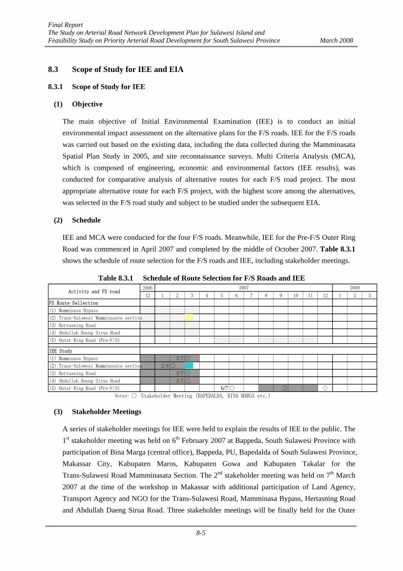
(2) Schedule
IEE and MCA were conducted for the four F/S roads. Meanwhile, IEE for the Pre-F/S Outer Ring Road was commenced in April 2007 and completed by the middle of October 2007. Table 8.3.1 shows the schedule of route selection for the F/S roads and IEE, including stakeholder meetings.
Table 8.3.1 Schedule of Route Selection for F/S Roads and IEE 2006
12 1 2 3 4 5 6 7 8 9 10 11 12 1 2 3
FS Route Sellection
(1) Mamminasa Bypass
(2) Trans-Sulawesi Mamminasata section
(3) Hertasning Road
(4) Abdullah Daeng Sirua Road
(5) Outer Ring Road (Pre-F/S)
IEE Study
(1) Mamminasa Bypass 3/7 ○
(2) Trans-Sulawesi Mamminasata section 2/6 ○
(3) Hertasning Road 3/7 ○
(4) Abdullah Daeng Sirua Road 3/7 ○
(5) Outer Ring Road (Pre-F/S) 6/7 ○ ○ ○
Notes: ○ Stakeholder Meeting (BAPEDALDA, BINA MARGA etc.)
Activity and FS road2007 2008
(3) Stakeholder Meetings
A series of stakeholder meetings for IEE were held to explain the results of IEE to the public. The 1st stakeholder meeting was held on 6th February 2007 at Bappeda, South Sulawesi Province with participation of Bina Marga (central office), Bappeda, PU, Bapedalda of South Sulawesi Province, Makassar City, Kabupaten Maros, Kabupaten Gowa and Kabupaten Takalar for the Trans-Sulawesi Road Mamminasata Section. The 2nd stakeholder meeting was held on 7th March 2007 at the time of the workshop in Makassar with additional participation of Land Agency, Transport Agency and NGO for the Trans-Sulawesi Road, Mamminasa Bypass, Hertasning Road and Abdullah Daeng Sirua Road. Three stakeholder meetings will be finally held for the Outer
Final Report The Study on Arterial Road Network Development Plan for Sulawesi Island and Feasibility Study on Priority Arterial Road Development for South Sulawesi Province March 2008
8-6
Ring Road. Since only pre-F/S study is required for the Outer Ring Road, only IEE-level study was conducted for this road.
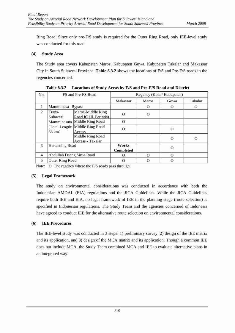
(4) Study Area
The Study area covers Kabupaten Maros, Kabupaten Gowa, Kabupaten Takalar and Makassar City in South Sulawesi Province. Table 8.3.2 shows the locations of F/S and Pre-F/S roads in the regencies concerned.
Table 8.3.2 Locations of Study Areas by F/S and Pre-F/S Road and District No.
Makassar Maros Gowa Takalar1 O O O2 Maros-Middle Ring
Road IC (Jl. Perintis)O O
Middle Ring Road OMiddle Ring RoadAccess
O O
Middle Ring RoadAccess - Takalar
O O
3 WorksCompleted O
4 O O O5 O O O
Note: O The regency where the F/S roads pass through.Outer Ring RoadAbdullah Daeng Sirua Road
Trans-SulawesiMamminasata(Total Length:58 km)
Mamminasa Bypass
Hertasning Road
FS and Pre-FS Road Regency (Kota / Kabupaten)
(5) Legal Framework
The study on environmental considerations was conducted in accordance with both the Indonesian AMDAL (EIA) regulations and the JICA Guidelines. While the JICA Guidelines require both IEE and EIA, no legal framework of IEE in the planning stage (route selection) is specified in Indonesian regulations. The Study Team and the agencies concerned of Indonesia have agreed to conduct IEE for the alternative route selection on environmental considerations.
(6) IEE Procedures
The IEE-level study was conducted in 3 steps: 1) preliminary survey, 2) design of the IEE matrix and its application, and 3) design of the MCA matrix and its application. Though a common IEE does not include MCA, the Study Team combined MCA and IEE to evaluate alternative plans in an integrated way.

Final Report The Study on Arterial Road Network Development Plan for Sulawesi Island and Feasibility Study on Priority Arterial Road Development for South Sulawesi Province March 2008
8-7
8.3.2 Scope of Study for EIA
(1) Scope of Study
The scope of the EIA (AMDAL) study covers the following items: Scope of the project to be studied
Main issues Scope of the Study area
Study methods Data collection and analysis method Major and significant impact prediction method Major and significant impact evaluation method
Project owner identity Executing agency EIA study team Study costs Study period
Bibliography.
The EIA study also covers UKL (Environmental Management Plan) and UPL (Environmental Monitoring Plan).
(2) Objectives
The major objectives of the EIA study are: To carry out more in-depth field surveys covering a wide range of environmental and
socio-economic baseline information; To quantitatively and qualitatively assess significance of a wide range of potential
impacts by the selected road development plan; and To summarize environmental mitigation measures and establish environmental
management plan including environmental monitoring plan during both pre-construction and post-construction phases.
Though EIA generally deals with negative environmental impacts, positive effects will also be estimated in this study. In accordance with the result of EIA and public consultations, the proposed projects will be reviewed by BAPEDALDA and approved by the Governors.
(3) Schedule
The EIA study is being conducted for the F/S roads: the Mamminasa Bypass, Trans-Sulawesi Road Mamminasata Section, Hertasning Road and Abdullah Daeng Sirua Road. Those roads are classified into two groups: the 1st group consists of the Trans-Sulawesi Road and the 2nd group consists of the other 3 roads. The Terms of Reference (TOR) for EIA was prepared for each group. Table 8.3.3 shows the schedule of F/S, EIA and stakeholder meetings.

Final Report The Study on Arterial Road Network Development Plan for Sulawesi Island and Feasibility Study on Priority Arterial Road Development for South Sulawesi Province March 2008
8-8
Table 8.3.3 Schedule of F/S Study and EIA
200612 1 2 3 4 5 6 7 8 9 10 11 12 1 2 3
FS Study(1) Mamminasa Bypass
(2) Trans-Sulawesi Mamminasata section
(3) Hertasning Road
(4) Abdullah Daeng Sirua Road
EIA StudyEIA approval
● ◎ ○ ◎
EIA EIA approval● ◎ ○ ◎
Notes:◎Following both Indonesian EIA procedure and JICA guideline
● Following only Indonesian Guideline
○ Following only JICA guideline
Activity and FS road
Group 1 (2) Trans-Sulawesi Mamminasatasection
Group 2 (1) Mamminasa Bypass (3) Hertasning Road (4) Abdullah Daeng Sirua Road
2007 2008
(4) Stakeholder Meetings (Public Consultations)
A series of public consultations are basic requirements in EIA and for its approval. Four public consultation sessions are scheduled for each F/S road project. Participants to the public consultation are Bina Marga, Bappedalda of Kabupaten Maros, Kabupaten Gowa, Kabupaten Takalar and Makassar City, local government agencies, general public from affected villages, representatives of educational societies, religious societies, women’s association, NGO, business associations and others.
(5) Study Area
The study area covers the specified areas in Kabupaten Maros, Kabupaten Gowa, Kabupaten Takalar and Makassar City (refer to Table 8.3.2) along the F/S roads to be affected directly and indirectly by planning and implementation of the Project.
(6) Legal Framework
The EIA (AMDAL) study was conducted in accordance with the Indonesian regulations, for which related documents are listed below, and “JICA Guidelines for Environmental and Social Considerations”.
1. Undang-undang No. 5 tahun 1960 concerning Basic Agrarian Regulation 2. Undang-Undang No. 5 tahun 1990 concerning Ecosystem and Natural Biological
Conservation 3. Undang-Undang No. 4 tahun 1992 concerning Housings and Settlement 4. Undang-Undang No. 14 tahun 1992 concerning Traffic and Road Transportation 5. Undang-Undang No. 24 tahun 1992 concerning Spatial Plan 6. Undang-Undang No. 23 tahun 1997 concerning Environmental Management 7. Peraturan Pemerintah No. 20 tahun 1990 concerning Water Pollution
Final Report The Study on Arterial Road Network Development Plan for Sulawesi Island and Feasibility Study on Priority Arterial Road Development for South Sulawesi Province March 2008
8-9
8. Peraturan Pemerintah No. 27 tahun 1999 concerning AMDAL 9. Keputusan Menteri KLH No. Kep-02/MENKLH/1998, concerning Environment Quality
Standard Guidelines 10. Keputusan Menteri KLH No. Kep-14/MENLH/3/1994, concerning AMDAL
Compilation Guidelines 11. Kepka BAPEDAL No. 229/1996 concerning Technical Guidance on Social Aspect
Consideration in AMDAL Formulation 12. Kepka BAPEDAL No. 28/2000 concerning Society Involvement and Information
Disclosure in AMDAL Process 13. Kepka BAPEDAL No. 09/2000 concerning AMDAL Compilation Guidelines 14. Peraturan Menteri Negara Lingungan Hidup Nomor 11 TAHUN 2006, Regulation for
Types of Works and Activities to be Conducted in EIA 15. Peraturan Menteri Negara Lingkungan Hidup, Nomor 08 TAHUN 2006, Environmental
Impact Assessment Guidelines 16. Keputusan Gubernur Sulawesi Selatan, Nomor14 Tahun 2003, Quality Standard of
Water and Air Emission
(7) EIA procedures
EIA was conducted in accordance with the procedures illustrated in Figure 8.3.1. The procedures meet the Indonesian EIA regulations in principle. The 2nd Public Consultation is an additional requirement to satisfy the JICA Guidelines.

Final Report The Study on Arterial Road Network Development Plan for Sulawesi Island and Feasibility Study on Priority Arterial Road Development for South Sulawesi Province March 2008
8-10
Draft TOR/EIA
Preparation of draftTOR/EIA
Examination of DraftTOR/EIA
1st PublicConsultationconducted by
BAPEDALDA
Preparation of reviseddraft TOR/EIA based
on 1st PublicConsultation
Finalized TOR/EIAApproval of Final
TOR/EIA byTechnical
Committee ofAMDAL
Conduct EIA(Onsite survey, Estimation,
Evaluation and Considerationof Mitigations)
Preparation of DraftFinal EIS based on
3rd PublicConsultaion
Draft Final EIS(ANDAL,RKL
&RPL)
Final EIS(ANDAL,RKL
&RPL)Approval of Final EIS
by TechnicalCommittee of
AMDAL
3rd PublicConsultation
conducted withBAPEDALDA
Finalization of FinalEIS based on 4th
Public Consultation
Bina Marga & DinasPrasarana Wilayah
BAPEDALDAProvince
PAP (General Public)
Publificationby newspaper
Participate in thePublic Consultation
Participate in thePublic Consultation
Participate in thePublic Consultation
Participate in thePublic Consultation
Preraration of TOR/EIA
Implementation of EIS
3rd Public Consultation shouldbe done under JICA Guideline
Participate in thePublic
2nd PublicConsultationconducted by
BAPEDALDA
Participate in thePublic
Finalization of FinalTOR/EIA based on
2nd PublicConsultation
Final TOR/EIA
Participate in thePublic
4th PublicConsultation
conducted withBAPEDALDA
Participate in thePublic
Examination ofDraft Final EIS
Final EIS Report(ANDAL
RKL&RPL)
Comment
ApprovedFinal EIS
Comment
Approved FinalTOR/EIA
Participation
Participation
Participation
Participation
Comment
Comment
Participation
Participation
Participation
Participation
Submission
Submission
Submission
Submission
Submission Examination ofrevised Draft
TOR/EIA
revised Draft TOR/EIA
Figure 8.3.1 EIA Procedures
Final Report The Study on Arterial Road Network Development Plan for Sulawesi Island and Feasibility Study on Priority Arterial Road Development for South Sulawesi Province March 2008
8-11
8.4 Methodology for IEE and EIA
8.4.1 Methodology for IEE
(1) Preliminary Survey
Preliminary survey was carried out using the existing data and conducting site reconnaissance. Major public infrastructure and private facilities including schools, mosques, cemeteries, government offices, hospitals, markets, bus stations, etc. along the alternative routes for the F/S projects were identified by site reconnaissance surveys conducted by relevant officers. Rivers, swamps and other essential natural landmarks were also identified through those site surveys. The required scale and seriousness of resettlements were estimated based on satellite images of topographic maps produced in the Mamminasata Spatial Plan Study.
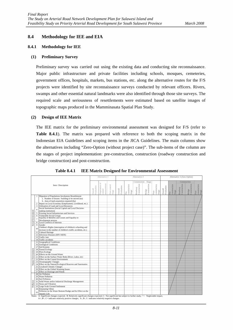
(2) Design of IEE Matrix
The IEE matrix for the preliminary environmental assessment was designed for F/S (refer to Table 8.4.1). The matrix was prepared with reference to both the scoping matrix in the Indonesian EIA Guidelines and scoping items in the JICA Guidelines. The main columns show the alternatives including “Zero-Option (without project case)”. The sub-items of the column are the stages of project implementation: pre-construction, construction (roadway construction and bridge construction) and post-construction.
Table 8.4.1 IEE Matrix Designed for Environmental Assessment
Roa
dway
Con
stru
ctio
n
Brid
geC
onst
ruct
ion
Roa
dway
Con
stru
ctio
n
Brid
geC
onst
ruct
ion
1 Migration of Populations Involuntary Resettlement
2 Impact on Local Economy (Employment, Livelihood, etc.)3 Utilization of Land and Local Resources
4
5 Existing Social Infrastructure and Services6 Vulnerable Social Groups78 Local Conflicts of Interests9 Gender
10
11 Cultural Heritage12 Infectious Diseases (HIV/AIDS)13 Traffic Jam14 Traffic accidents151617181920212223242526 Effect on the Global Warming Issues27 Effect on Drainage and Floods28293031323334
35
Notes: A: Significant changes expected, B: Relatively significant changes expected, C: Not significant but subject to further study, "-": Neglectable impact, A+, B+, C+ indicates relatively positive changes, A-, B-, C- indicates relatively negative changes.
Ove
rall
Eval
uatio
n
Alternative 3 (Zero-Option)
Pre-
cons
truct
ion
Stag
e
Construction Stage
Post
-co
nstru
ctio
nSt
age
Construction
Post
-co
nstru
ctio
nSt
age
Ove
rall
Eval
uatio
n
Pre-
cons
truct
ion
Stag
e
Oceanographic Changes
Alternative 1 Alternative 2
Ove
rall
Eval
uatio
n
Prep
arat
ion
ofco
ntro
lm
easu
rem
ent
Social Institutions (Social Capital and Local Decision-making institution)
Equality of Benefits and Losses and Equality inDevelopment process
Item / Description
Post
-con
trol
Stag
e
Soci
al E
nviro
nmen
tN
atur
al E
nviro
nmen
tPo
llutio
n
Effects on the Ground Water
Air PollutionWater Pollution
Children's Rights (interruption of children's schooling andincrease in the number of children's traffic accidents, etc.)
a. Number of houses / building to be moved (no)
Soil Pollution
b. Area of land acquisition required (ha)
Large Scale Ground SettlementEmanating Odour
Faunal Ecology
Geographical ConditionsGeological ConditionsSoil Erosion
Pollution on the Water Bottom/Sludge and Its Effect on theAquatic Life
Noise and Vibration
Flora Ecology
Effect on the Natural/Ecological Reserves and SanctuariesLocalised Climatic Changes
Effect on the Surface Water Body (River, Lakes, etc)Effect on the Coastal Environment
Solid Waste and/or Industrial Discharge Management
Final Report The Study on Arterial Road Network Development Plan for Sulawesi Island and Feasibility Study on Priority Arterial Road Development for South Sulawesi Province March 2008
8-12
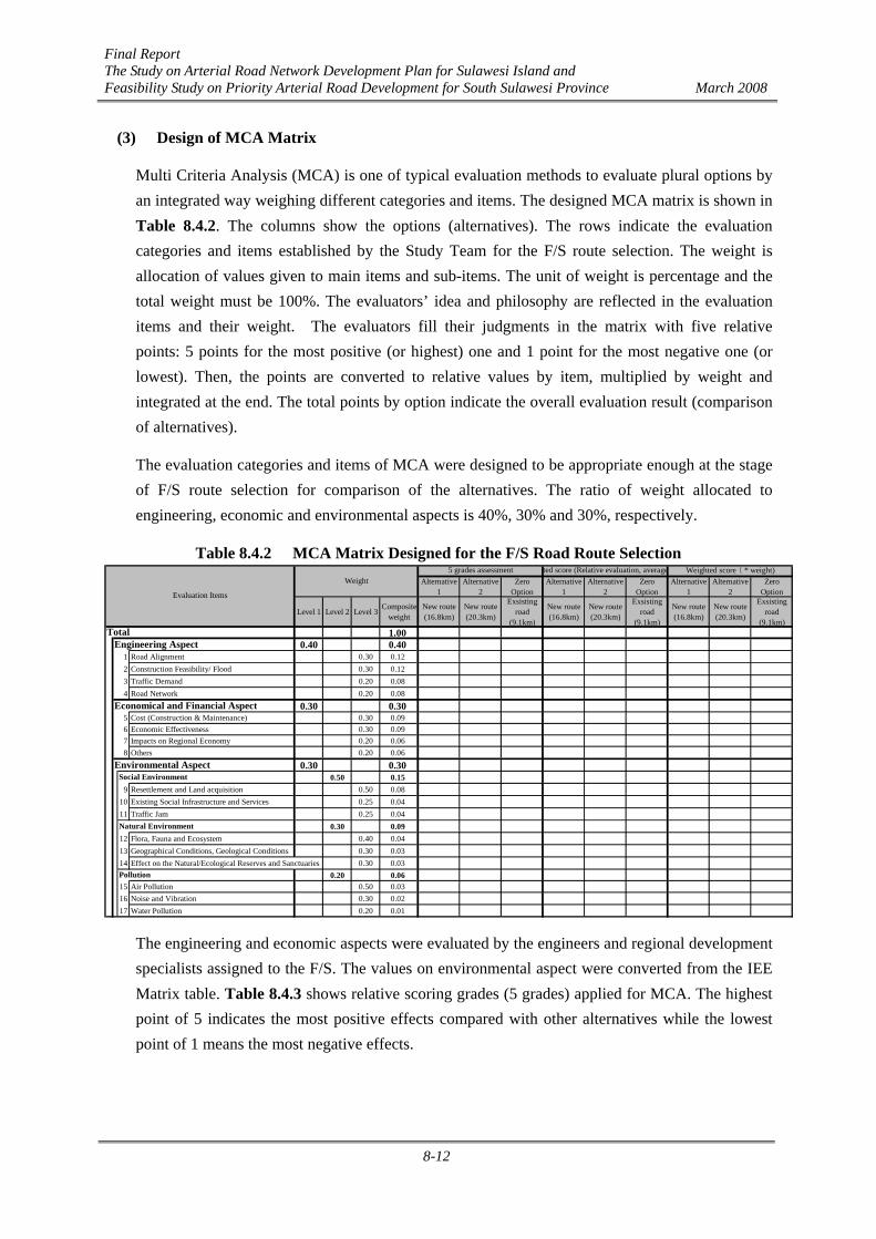
(3) Design of MCA Matrix
Multi Criteria Analysis (MCA) is one of typical evaluation methods to evaluate plural options by an integrated way weighing different categories and items. The designed MCA matrix is shown in Table 8.4.2. The columns show the options (alternatives). The rows indicate the evaluation categories and items established by the Study Team for the F/S route selection. The weight is allocation of values given to main items and sub-items. The unit of weight is percentage and the total weight must be 100%. The evaluators’ idea and philosophy are reflected in the evaluation items and their weight. The evaluators fill their judgments in the matrix with five relative points: 5 points for the most positive (or highest) one and 1 point for the most negative one (or lowest). Then, the points are converted to relative values by item, multiplied by weight and integrated at the end. The total points by option indicate the overall evaluation result (comparison of alternatives).
The evaluation categories and items of MCA were designed to be appropriate enough at the stage of F/S route selection for comparison of the alternatives. The ratio of weight allocated to engineering, economic and environmental aspects is 40%, 30% and 30%, respectively.
Table 8.4.2 MCA Matrix Designed for the F/S Road Route Selection Alternative
1Alternative
2Zero
OptionAlternative
1Alternative
2Zero
OptionAlternative
1Alternative
2Zero
Option
Level 1 Level 2 Level 3Composite
weightNew route(16.8km)
New route(20.3km)
Exsistingroad
(9.1km)
New route(16.8km)
New route(20.3km)
Exsistingroad
(9.1km)
New route(16.8km)
New route(20.3km)
Exsistingroad
(9.1km)1.00
0.40 0.401 Road Alignment 0.30 0.122 Construction Feasibility/ Flood 0.30 0.123 Traffic Demand 0.20 0.084 Road Network 0.20 0.08
0.30 0.305 Cost (Construction & Maintenance) 0.30 0.096 Economic Effectiveness 0.30 0.097 Impacts on Regional Economy 0.20 0.068 Others 0.20 0.06
0.30 0.300.50 0.15
9 Resettlement and Land acquisition 0.50 0.0810 Existing Social Infrastructure and Services 0.25 0.0411 Traffic Jam 0.25 0.04
0.30 0.0912 Flora, Fauna and Ecosystem 0.40 0.0413 Geographical Conditions, Geological Conditions 0.30 0.0314 Effect on the Natural/Ecological Reserves and Sanctuaries 0.30 0.03
0.20 0.0615 Air Pollution 0.50 0.0316 Noise and Vibration 0.30 0.0217 Water Pollution 0.20 0.01
Weighted score ( * weight)Weight
Natural Environment
rted score (Relative evaluation, average
Social Environment
5 grades assessment
Engineering Aspect
Pollution
Evaluation Items
Total
Economical and Financial Aspect
Environmental Aspect
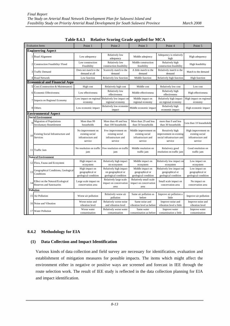
The engineering and economic aspects were evaluated by the engineers and regional development specialists assigned to the F/S. The values on environmental aspect were converted from the IEE Matrix table. Table 8.4.3 shows relative scoring grades (5 grades) applied for MCA. The highest point of 5 indicates the most positive effects compared with other alternatives while the lowest point of 1 means the most negative effects.
Final Report The Study on Arterial Road Network Development Plan for Sulawesi Island and Feasibility Study on Priority Arterial Road Development for South Sulawesi Province March 2008
8-13
Table 8.4.3 Relative Scoring Grade applied for MCA Evaluation Items Point 1 Point 2 Point 3 Point 4 Point 5
1 Road Alignment Low adequency Relatively lowadequency Middle adeqiency Adequency is relatively
high High adequency
2 Construction Feasibility/ Flood Low constructionFeasibility
Relatively lowconstruction feasibility
Middle constructionfeasibility
Relatively highconstruction feasibility High feasibility
3 Traffic Demand Does not match to thedemand at all
Scarecely match to thedemand
A little match to thedemand
Relatively match to thedemand Match to the demand
4 Road Network Low function Relatively low function Middle function Relatively high function High function
5 Cost (Construction & Maintenance) High cost Relatively high cost Middle cost Relatively low cost Low cost
6 Economic Effectiveness Low effectiveness Relatively loweffectiveness Middle effectiveness Relatively high
effectiveness High effectiveness
7 Impacts on Regional Economy Low impact on regionaleconomy
Relatively low impact onregional economy
Middle impact onregional economy
Relatively high impacton regional economy
High impact on regionaleconomy
8 Others Low economic impact Relatively low economicimpact Middle economic impact Relatively high
economic impact High economic impact
9 Migration of PopulationsInvoluntary Resettlement
More than 99households
More than 49 and lessthan 100 households
More than 29 and lessthan 50 households
more than 9 and lessthan 30 households Less than 10 househokds
10 Existing Social Infrastructure andServices
No improvement onexisting social
infrastructure andservice
Few improvement onexisting social
infrastructure andservice
Middle improvement onexisting social
infrastructure andservice
Reratively highimprovement on existingsocial infrastructure and
service
High improvement onexisting social
infrastructure andservice
11 Traffic Jam No resolution on trafficjam
Few resolution on trafficjam
Middle resolution ontraffic jam
Relativery goodresolution on traffic jam
Good resolution ontraffic jam
12 Flora, Fauna and Ecosystem High impact onecosystem
Relatively high impacton ecosystem
Middle impact onecosystem
Relatively low impact onecosystem
Low impact onecosystem
13 Geographical Conditions, GeologicalConditions
High impact ongeographical or
geological condition
Relatively high impacton geographical or
geological condition
Middle impact ongeographical or
geological condition
Relatively low impact ongeographical or
geological condition
Low impact ongeographical or
geological condition
14 Effect on the Natural/EcologicalReserves and Sanctuaries
Large scale impact onconcervation area
Relatively large scaleimpact on concervation
area
Relatively small scaleimpact on concervation
area
Small scale impact onconcervation area
No impact onconcervation area
15 Air Pollution Worse air pollution Relatively worse airpollution
Same air pollution asbefore
Improve air pollution alittle Improve air pollution
16 Noise and Vibration Worse noise andvibration level
Relatively worse noiseand vibration level
Same noise andvibration level as before
Improve noise andvibration level a little
Improve noise andvibration level
17 Water Pollution Worse watercontamination
Relatively worse watercontamination
Same watercontamination as before
Improve watercontamination a little
Improve watercontamination
Engineering Aspect
Economical and Financial Aspec
Environmental Aspect
Pollution
Natural Environment
Social Environment
8.4.2 Methodology for EIA
(1) Data Collection and Impact Identification
Various kinds of data collection and field survey are necessary for identification, evaluation and establishment of mitigation measures for possible impacts. The items which might affect the environment either in negative or positive ways are screened and forecast in IEE through the route selection work. The result of IEE study is reflected in the data collection planning for EIA and impact identification.
Final Report The Study on Arterial Road Network Development Plan for Sulawesi Island and Feasibility Study on Priority Arterial Road Development for South Sulawesi Province March 2008
8-14
(2) Field Survey
1) Natural Environment
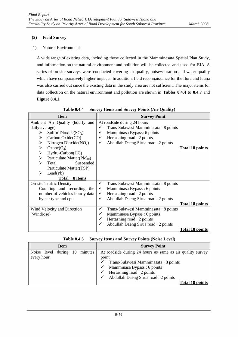
A wide range of existing data, including those collected in the Mamminasata Spatial Plan Study, and information on the natural environment and pollution will be collected and used for EIA. A series of on-site surveys were conducted covering air quality, noise/vibration and water quality which have comparatively higher impacts. In addition, field reconnaissance for the flora and fauna was also carried out since the existing data in the study area are not sufficient. The major items for data collection on the natural environment and pollution are shown in Tables 8.4.4 to 8.4.7 and Figure 8.4.1.
Table 8.4.4 Survey Items and Survey Points (Air Quality) Item Survey Point
Ambient Air Quality (hourly and daily average)
Sulfur Dioxide(SO2) Carbon Oxide(CO) Nitrogen Dioxide(NO2) Ozone(O3) Hydro-Carbon(HC) Particulate Matter(PM10) Total Suspended
Particulate Matter(TSP) Lead(Pb)
Total 8 items
At roadside during 24 hours Trans-Sulawesi Mamminasata : 8 points Mamminasa Bypass: 6 points Hertasning road : 2 points Abdullah Daeng Sirua road : 2 points
Total 18 points
On-site Traffic Density Counting and recording the number of vehicles hourly data by car type and cpu
Trans-Sulawesi Mamminasata : 8 points Mamminasa Bypass : 6 points Hertasning road : 2 points Abdullah Daeng Sirua road : 2 points
Total 18 pointsWind Velocity and Direction (Windrose)
Trans-Sulawesi Mamminasata : 8 points Mamminasa Bypass : 6 points Hertasning road : 2 points Abdullah Daeng Sirua road : 2 points
Total 18 points
Table 8.4.5 Survey Items and Survey Points (Noise Level) Item Survey Point
Noise level during 10 minutes every hour
At roadside during 24 hours as same as air quality survey point
Trans-Sulawesi Mamminasata : 8 points Mamminasa Bypass : 6 points Hertasning road : 2 points Abdullah Daeng Sirua road : 2 points
Total 18 points

Final Report The Study on Arterial Road Network Development Plan for Sulawesi Island and Feasibility Study on Priority Arterial Road Development for South Sulawesi Province March 2008
8-15
Table 8.4.6 Survey Items and Survey Points (Water Quality) Item Survey Point
Temperature Color Total Dissolved Solid(TDS) Total Suspended Solid(TSS) Electric Conductivity(EC) Turbidity (Physical :6 items) pH Biological Oxygen Demand(BOD5) Chemical Oxygen Demand(COD) Dissolved Oxygen(DO) Total Phosphate(P) Nitrate(NO3-N) Ammonium(NH3–N) Cadmium(Cd) Chrome(CrVI) Cuprum(Cu) Iron(Fe) Lead(Pb) Manganese(Mn) Mercury(Hg) Zink (Zn) Chloride (Cl) Cyanide (Cn) Fluoride (F) Nitrite (NO2-N) Sulphate (SO4) Cl2 – free H2S CaCO3 Calcium (ca) (Chemical :24 items) Oil and Grease Detergent (MBAS) Fenolic (Organic Chemical :3 items) Fecal Coliform Total Coliforms (Microorganism :2 items)
Total 35 items
At cross points of river and canal (including canal along routes) in dry season
Trans-Sulawesi Mamminasata : 6 points Mamminasa Bypass : 4 points Abdullah Daeng Sirua road : 1 points
Total 11 points
Table 8.4.7 Survey Items and Survey Points (Flora and Fauna) Items Survey point
Flora :General vegetation patterns, Plant species, Tree species, Rare plant species in entire area, Others Fauna :Amphibians, Reptiles, Mammals, Birds, Rare faunal species, Others Arrangement of data by kind and species, common name, habitat, endemism, protected or not and so on
Along proposed routes and in relatively high natural environmental condition area Trans-Sulawesi Mamminasata : 3 areas (around Tallo river and C section) Mamminasa Bypass road : 8 areas (along all of proposed routes) Hertasning road : 1 area (middle part of this route) Abdullah Daeng Sirua road : 1 area (middle part of this route)
Total 14 area

Final Report The Study on Arterial Road Network Development Plan for Sulawesi Island and Feasibility Study on Priority Arterial Road Development for South Sulawesi Province March 2008
8-16
▲ Air quality, Noise level and Traffic density : 18 points
▲ Water quality sampling : 10 points
Fauna and Flora survey area: 14 area
Air quality sampling
Water quality sampling
Noise level test
▲ Air quality, Noise level and Traffic density : 18 points
▲ Water quality sampling : 10 points
Fauna and Flora survey area: 14 area
Air quality sampling
Water quality sampling
Noise level test
Figure 8.4.1 Site Survey Points for Natural Environment
The survey of natural environment and pollutions was carried out from the end of March to the beginning of June 2007. Regarding pollution, the dates of survey and sampling points are shown in Table 8.4.8. The field reconnaissance on flora and fauna in the rainy season was conducted from the end of March to the beginning of April 2007. The dry season survey was done between the end of May and the middle of June.
Table 8.4.8 Date of Survey for Pollution and Sampling Points Pollution Item Date of Practice
Air Quality, Noise Level, Traffic Density, Wind Velocity and Direction
Trans-Sulawesi Road (No.1~8, 15) : 1st to 12th of May 2007Mamminasa Bypass (No.1, 5, 9~14) : 1st,8th,14th ,18th,19th,
21s t to 23rd of May Hertasning (No.11,15, 16) : 4th,22nd,24th of May Abdullah Daeng Sirua (No.10, 17, 18) : 15th,16th,23rd of May
Water Quality No.1, 4~9 : 24th of May 2007 No.2, 3, 8~11 : 25th of May 2007

Final Report The Study on Arterial Road Network Development Plan for Sulawesi Island and Feasibility Study on Priority Arterial Road Development for South Sulawesi Province March 2008
8-17
2) Social Environment
The survey items include economy, health, daily life by region, income level, generation, etc. as listed in Table 8.4.9. Questionnaire surveys along the F/S roads were carried out and approximately 200 answers were obtained (refer to Table 8.4.9). The interview survey of Group 1 (Trans-Sulawesi Road Mamminasata section) was carried out in May 2007, and 150 sheets of answers by the affected people were collected. Regarding Group 2, the interview survey was carried out in October 2007, and 40 sheets of answers by the affected people were collected.
Table 8.4.9 Survey Items and Survey Points (Social Environment) Item Survey Point
Economy, health, daily life, surrounding environment condition, etc. by region, income level, generation, etc.
Along proposed routes Target number of answers : about 250 Trans-Sulawesi Mamminasata : 58 km Mamminasa Bypass road : 27.9 km Hertasning road : 4.5 km Abdullah Daeng Sirua road : 17.9 km Total 4 routes (length 108.3km)
(3) Methodology for Impact Assessment
1) Air Quality Prediction
i) The pollution volume is calculated from the exhaust gas of vehicles referring to the exhaust regulation in Indonesia.
ii) The statistical future air quality level is predicted from the result of on-site survey. After statistical analysis between air quality and traffic volume, future air quality level is predicted using the projected traffic volume along the F/S route.
2) Noise Level Prediction
Relationships between noise level and traffic volume are identified. The future noise level is predicted based on the result of on-site survey. After statistical analysis between noise level and traffic volume, future noise level is predicted using the projected traffic volume along the F/S route.
3) Water Quality Prediction
Water quality is predicted referring to the regulation on discharge and present condition data on the rivers where the F/S road is constructed.
4) Flora and fauna
i) A list of existing flora and fauna along the F/S roads will be compared with the list of endangered species, such as Red Data Book (RDB).
ii) Assessed distribution areas are indicated in the flora and fauna maps produced by the Study Team.
Final Report The Study on Arterial Road Network Development Plan for Sulawesi Island and Feasibility Study on Priority Arterial Road Development for South Sulawesi Province March 2008
8-18
iii) These maps are layered on the road F/S route map and the possible impact area will be identified.
5) Social Environment
The impact prediction and evaluations have been and are being conducted through the following procedures.
i) Socio-economic impacts on possible PAPs.
ii) Counting of the number of PAPs and identification of the locations of those PAPs by using satellite maps (Google Earth) and topographic maps and confirmation through field survey.
Estimated quantitative socio-economic impacts on possible PAPs include the following items:
Population to be resettled (by gender, ethnics, age, etc.)
Number of households to be resettled
Estimated affected area for land acquisition (agricultural, residential and other areas)
Number and scale of structures (houses, shops, offices, factories) to be resettled
Number and scale of public infrastructures (public facilities, public utilities and regional infrastructure)
Other socio-economic impacts on PAPs
The predicted impacts are being comprehensively evaluated by summing up positive and negative impacts based on the quantitative and qualitative methods. In addition, evaluation on the impact on the social environment is being analyzed more deeply from outcomes of the questionnaire survey on PAPs as well as other socio-economic surveys to identify and assess potential social impacts.

Final Report The Study on Arterial Road Network Development Plan for Sulawesi Island and Feasibility Study on Priority Arterial Road Development for South Sulawesi Province March 2008
8-19
Start Section in Kab. Takalar
8.5 Summary of IEE for Route Selection for F/S Roads
8.5.1 Preliminary Survey for IEE
Preliminary survey was conducted to identify possible impacts as well as the scale and extent on both natural and socio-economic environments. It was observed that more than 90% of the areas where the F/S roads pass through are farmland or urbanized areas, while the remaining 10% is lowland (swamps) or uncultivated land. There are a restriction area near the Outer Ring Road at the northern upstream part of the Tallo River and a planned flood retarding area at the southern upstream part of the same river.
Since the F/S roads are urban roads, land acquisition and resettlement are the critical issues in both project planning and implementation. It is estimated that resettlement of approximately 2,000 households is required as shown in Table 8.5.1. Maximum efforts should be made to minimize the number of PAPs to be resettled during the design stage.
8.5.2 IEE for Mamminasa Bypass
(1) South Section
The south section of the Mamminasa Bypass passes through a rural area where many paddy fields and farmlands are still dominant in many villages except for the area along the national road to Takalar. The F/S route crosses the Jeneberang River, the largest river in Mamminasata, at the end of this section.
Agriculture is currently one of the main economic activities along this route. As a result of the development of the irrigation system from the Bili-bili Dam, agricultural productions in this region will be stable in the future. A bridge was constructed over the mouth of the Jeneberang River in 2005 and, therefore, the south area has a direct access to the Makassar City center and Tanjung Bunga. Therefore, natural urbanization is unavoidable along the Tanjung Bunga road. As the population density is still relatively low, public facilities and lifeline are not yet well provided. Because of the relatively small size of wetland and no existence of forest, biodiversity seems to be low. Common species of flora and fauna are found around this area.
There are no significant negative impacts (A-) for Alternative 1 (the recommended F/S route). Some negative impacts (B-) are anticipated in 12 items. Land acquisition and resettlement in the pre-construction stage will be the most essential issues on social environmental considerations. Two items, soil erosion and effect on the water in the Jeneberang River during the construction

Final Report The Study on Arterial Road Network Development Plan for Sulawesi Island and Feasibility Study on Priority Arterial Road Development for South Sulawesi Province March 2008
8-20
stage were screened out in the natural environmental category. Water contamination and noise caused by the operation of heavy equipment (machines and trucks, etc.) are also anticipated. As the traffic will increase in the future, the air quality and noise will become worse compared with the present condition. On the other hand, positive impacts on local economic activities, land use and utilization of local resources are expected. Traffic jam on the existing road will be improved conspicuously while serious traffic jam is anticipated as the traffic volume will far exceed the capacity in the without-project case.
(2) Middle Section
The proposed F/S route of the middle section of the Mamminasa Bypass passes through the rural area in Maros and Gowa districts. The route crosses upstream the Tallo River. The F/S route for Alternative 1 avoids most of small villages. Paddy fields in the lowland and crop cultivation fields on the rolling terrain are spreading around the F/S road. The cross point of the PDAM canal from the Lekopancing barrage to Makassar city exists on the route.
This middle section route passes through the area of low population density but around the cross points of existing roads, there are some houses to be resettled. Along this route the lifeline is well developed but some of the roads are in bad condition in the rainy season. It is assumed that biodiversity is relatively low.
There are no significant negative impacts (A-) for Alternative 1 (the recommended F/S route).
Relatively negative impacts (B-) are anticipated in 12 items. Land acquisition and resettlement at the pre-construction stage will be the most essential issues. Natural environmental condition and pollution are almost same as in the above start section. Minor soil erosion, effect on surface water and water contamination in the Tallo River might occur in the construction stage. Noise pollution is anticipated in the construction stage. Air quality and noise will become worse compared with the without-project case. Significant positive impacts on local economic activities, land use and utilization of local resources are expected. Traffic jam will be improved conspicuously. The road is also expected to contribute to inducing new satellite towns at the foot of Mt. Moncongloe.
Middle Section in Kab.Gowa (Cross Point of Malino Road)
Middle Section in Kab. Gowa (Cross point with Existing road)

Final Report The Study on Arterial Road Network Development Plan for Sulawesi Island and Feasibility Study on Priority Arterial Road Development for South Sulawesi Province March 2008
8-21
(3) End (North) Section
The proposed F/S route of the end (north) section of the Mamminasa Bypass passes on the periphery of Maros town avoiding a planned flood retarding basin in paddy field. The bypass crosses over the Maros River at the east edge of Maros town and, then, the national road to Kabupaten Bone. It meets the national road to Parepare at about 1.5 km, at the northern end of Maros town.
Significant negative impacts (A-) are not expected for the recommended Alternative 1. Relatively negative impacts (B-) are anticipated in 12 items. Land acquisition and resettlement are the most essential issues among these items. In natural environmental category, soil erosion and effect on the water of the Maros River in the construction stage are anticipated. Noise increase is also anticipated. As the traffic volume will increase in the future, air quality and
noise will become worse compared with the present condition. However, the significant positive impacts on local economic activities, land use and utilization of local resources, solving traffic jam etc. , especially solving serious traffic jam in the Maros town center, are expected.
8.5.3 IEE for Trans-Sulawesi Road Mamminasata Section
(1) Section A (Maros-Middle Ring Road)
The road development concept of Section A is widening of the existing national road from 4 lanes to 6 or 8 lanes, except in the new Maros town area where the existing 4-lane road will be kept. The F/S road starts at Maros town and passes through the national road up to the intersection of Jl.Ir.Sutami (near the entrance to Makassar City) and, then, runs on Jl.Perintis Kemerdekaan up to the planned middle ring road interchange near the Tallo River Bridge. Many buildings and houses exist along the route, especially around the airport, Mandai, Biringkanaya and Daya towns.
The forecast traffic volume for Section A is higher than that of other roads and the population
End Section in Maros (Cross Point of Existing road)
End Section in Maros Town (Cross Point of Maros River)
Section A in Maros (At the District Governor’s Office)
Final Report The Study on Arterial Road Network Development Plan for Sulawesi Island and Feasibility Study on Priority Arterial Road Development for South Sulawesi Province March 2008
8-22
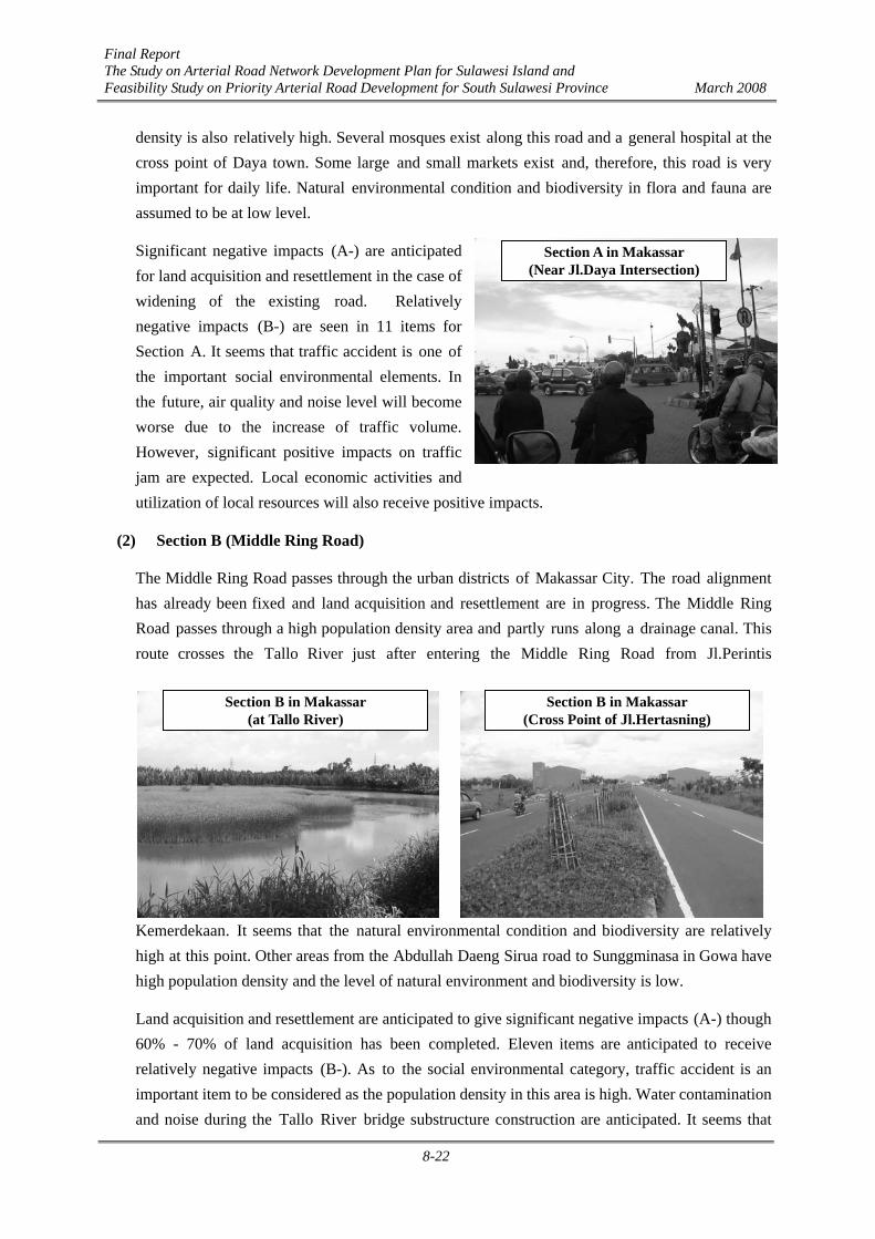
density is also relatively high. Several mosques exist along this road and a general hospital at the cross point of Daya town. Some large and small markets exist and, therefore, this road is very important for daily life. Natural environmental condition and biodiversity in flora and fauna are assumed to be at low level.
Significant negative impacts (A-) are anticipated for land acquisition and resettlement in the case of widening of the existing road. Relatively negative impacts (B-) are seen in 11 items for Section A. It seems that traffic accident is one of the important social environmental elements. In the future, air quality and noise level will become worse due to the increase of traffic volume. However, significant positive impacts on traffic jam are expected. Local economic activities and utilization of local resources will also receive positive impacts.
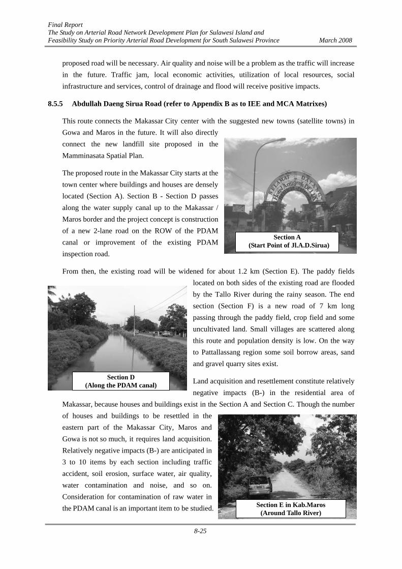
(2) Section B (Middle Ring Road)
The Middle Ring Road passes through the urban districts of Makassar City. The road alignment has already been fixed and land acquisition and resettlement are in progress. The Middle Ring Road passes through a high population density area and partly runs along a drainage canal. This route crosses the Tallo River just after entering the Middle Ring Road from Jl.Perintis
Kemerdekaan. It seems that the natural environmental condition and biodiversity are relatively high at this point. Other areas from the Abdullah Daeng Sirua road to Sunggminasa in Gowa have high population density and the level of natural environment and biodiversity is low.
Land acquisition and resettlement are anticipated to give significant negative impacts (A-) though 60% - 70% of land acquisition has been completed. Eleven items are anticipated to receive relatively negative impacts (B-). As to the social environmental category, traffic accident is an important item to be considered as the population density in this area is high. Water contamination and noise during the Tallo River bridge substructure construction are anticipated. It seems that
Section A in Makassar (Near Jl.Daya Intersection)
Section B in Makassar (at Tallo River)
Section B in Makassar (Cross Point of Jl.Hertasning)

Final Report The Study on Arterial Road Network Development Plan for Sulawesi Island and Feasibility Study on Priority Arterial Road Development for South Sulawesi Province March 2008
8-23
consideration for flora and fauna will be necessary according to on-site survey around the Tallo River. Air quality and noise will become worse in the future due to traffic increase. The Middle Ring Road will have a significant positive impact on traffic jam by reducing traffic on other urban roads. Utilization of local resources, social infrastructure and services will also receive positive impacts.
(3) Section C (Sungguminasa IC - National Road)
A new road construction was recommended by the Study Team. The new route crosses the Jeneberang River after the Sungguminasa IC. Paddy fields and villages are spreading along the new route in the south of the Jeneberang River. The population density is relatively small. It seems that possibility of endemic species is relatively low.
Land acquisition and resettlement have a relatively negative impact (B-) except around the Sungguminasa intersection. Twelve items might cause relatively negative impacts (B-) including land acquisition and resettlement. It seems that traffic accident is relatively important in the social environmental category as the traffic volume will increase. Soil erosion and effect on the surface
water are expected. Water contamination and noise pollution may happen during the Jeneberang River bridge construction. In addition, it seems that consideration for flora and fauna may be necessary around the proposed route alignment. Air quality and noise will be a problem in the future due to traffic increase. The new road will give a very big positive effect on traffic jam. Utilization of local resources, social infrastructure and services, control of drainage and flood will receive positive impacts.
Noise may happen during the Jeneberang River bridge construction. In addition, it seems that consideration for flora and fauna around the proposed route alignment may be necessary. Air quality and noise caused by traffic increase will be a problem in the future. The new road will give a very big positive effect on traffic jam. Utilization of local resources, social infrastructure and services, control of drainage and flood will receive positive impacts.
Section C in Kab.Gowa (Jeneberang River Bank)
Section C in Gowa (Around Kanjilo Village)

Final Report The Study on Arterial Road Network Development Plan for Sulawesi Island and Feasibility Study on Priority Arterial Road Development for South Sulawesi Province March 2008
8-24
(4) Section D (Boka - Takalar)
The development concept of Section D is widening of the existing national road from 2-lane road to 4-lane road. There is an irrigation canal on the east side along the road. On the way to Takalar town, small towns (Limbung in Gowa and Palleko in Takalar) exist. The population density along the road side is relatively high. Irrigated paddy cultivation is dominant along the road. Part of the national road near the central part of Takalar town has already been widened to 4 lanes.
The number of resettlements (houses and buildings) is large as widening can be made on the west side because the irrigation canal is located in the east. One item is classified as significant negative impact (A-) and eleven items are anticipated as relatively negative impacts (B-) including traffic accident, soil erosion, effect on the surface water, water contamination, noise and so on. It seems that consideration for flora will be necessary because
a lot of trees are planted along this route. In future, air quality and noise will be worsening due to the traffic increase. However, traffic jam improvement and utilization of local resources are positive impacts.
8.5.4 Hertasning Road (refer to Appendix B as to IEE and MCA Matrixes)
The existing Kabupaten road (Section D of the Hertasning Road) located in Pattallassang in Gowa will be widened from 2-lane road to 4-lane road. Paddy field and crop cultivation are dominant in landuse and the population density is relatively low. The existing road in Gowa had been in bad condition but it was improved recently.
Land acquisition and resettlement are significant negative impacts (A-) because some houses are located along the existing road. Relatively negative impacts (B-) are anticipated in 8 items including traffic accident, soil erosion, water contamination, noise level, and so on. It seems that consideration for flora and fauna along the
Section D in Kab.Gowa (Cross Point of Mamminasa Bypass)
Section D in Takalar (Near the District Governor’s Office)
Section D in Kab.Gowa (Around Tasilli Village)
Final Report The Study on Arterial Road Network Development Plan for Sulawesi Island and Feasibility Study on Priority Arterial Road Development for South Sulawesi Province March 2008
8-25
proposed road will be necessary. Air quality and noise will be a problem as the traffic will increase in the future. Traffic jam, local economic activities, utilization of local resources, social infrastructure and services, control of drainage and flood will receive positive impacts.
8.5.5 Abdullah Daeng Sirua Road (refer to Appendix B as to IEE and MCA Matrixes)
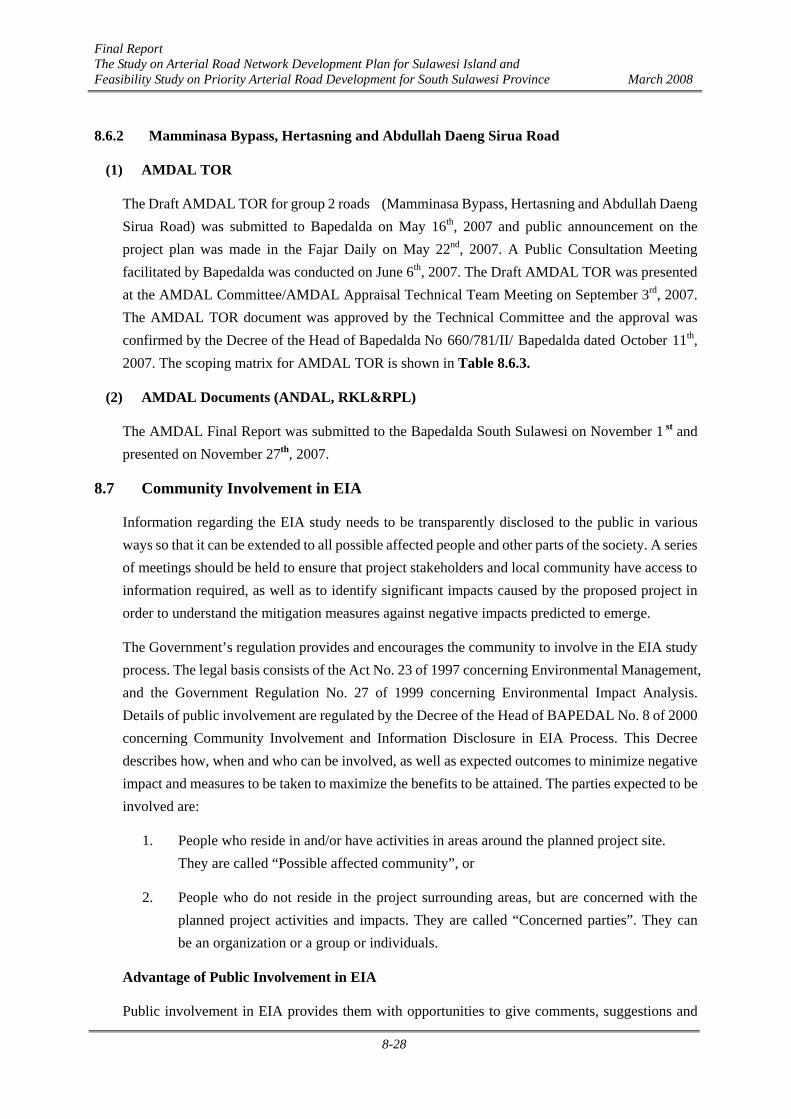
This route connects the Makassar City center with the suggested new towns (satellite towns) in Gowa and Maros in the future. It will also directly connect the new landfill site proposed in the Mamminasata Spatial Plan.
The proposed route in the Makassar City starts at the town center where buildings and houses are densely located (Section A). Section B - Section D passes along the water supply canal up to the Makassar / Maros border and the project concept is construction of a new 2-lane road on the ROW of the PDAM canal or improvement of the existing PDAM inspection road.
From then, the existing road will be widened for about 1.2 km (Section E). The paddy fields located on both sides of the existing road are flooded by the Tallo River during the rainy season. The end section (Section F) is a new road of 7 km long passing through the paddy field, crop field and some uncultivated land. Small villages are scattered along this route and population density is low. On the way to Pattallassang region some soil borrow areas, sand and gravel quarry sites exist.
Land acquisition and resettlement constitute relatively negative impacts (B-) in the residential area of
Makassar, because houses and buildings exist in the Section A and Section C. Though the number of houses and buildings to be resettled in the eastern part of the Makassar City, Maros and Gowa is not so much, it requires land acquisition. Relatively negative impacts (B-) are anticipated in 3 to 10 items by each section including traffic accident, soil erosion, surface water, air quality, water contamination and noise, and so on. Consideration for contamination of raw water in the PDAM canal is an important item to be studied.
Section A (Start Point of Jl.A.D.Sirua)
Section D (Along the PDAM canal)
Section E in Kab.Maros (Around Tallo River)

Final Report The Study on Arterial Road Network Development Plan for Sulawesi Island and Feasibility Study on Priority Arterial Road Development for South Sulawesi Province March 2008
8-26
In the construction stage of the bridge substructure, it is necessary to consider mitigation measures for controlling water contamination and noise. It seems that consideration for flora and fauna around the proposed route alignment will be necessary. In future, air quality and noise will be worsened in the Makassar City districts due to traffic increase. However, the F/S road will give positive impacts on traffic jam, local economic activities, utilization of local resources, social infrastructure and services, especially for the eastern part of the Makassar city, Moncongloe in Maros and Pattallassang in Gowa.
8.6 EIA Status for Feasibility Study Roads
The EIA (AMDAL) TOR was approved and the Final report or AMDAL Documents for two project groups were submitted to Bapedalda South Sulawesi Province by the Proponent, Directorate General of Highways, Ministry of Public Works (in this project, represented by the Public Infrastructure Agency South Sulawesi, whose representative was transferred to Balai Besar Pelaksana Jalan Nasional VI, Directorate General of Highways, Ministry of Public Works). Based on the draft proposed, Bapedalda announced the project implementation plan publicly afterwards through mass media. As for the 1st group roads, namely the Trans Sulawesi Mamminasata Road, the announcement on the project plan was published in the Fajar Daily on March 20th, 2007. A Public Consultation Meeting for the Trans Sulawesi Mamminasata Road, facilitated by Bapedalda, was held in April 2007. The TOR was approved by the AMDAL Appraisal Technical Team on May 28th, 2007. The Draft AMDAL Final Report (ANDAL, RKL and RPL) was presented and discussed at the AMDAL Committee/AMDAL Appraisal Technical Team Meeting on August 20th, 2007. Recommendations of the AMDAL Appraisal Technical Team on the Final Report, including ANDAL, RKL and RPL documents, were given in the letter No.660/745/II/Bapedalda dated September 28th, 2007. The AMDAL Documents’ approval was furthermore confirmed by the Decree of the Head of Bapedalda South Sulawesi Province No.660/746/II/Bapedalda, dated September 28th, 2007. The complete schedule of EIA is illustrated in Table 8.6.1.
Table 8.6.1 EIA Study Schedule Road Groups
Type of Document Group 1 Trans Sulawesi Mamminasata Road
Group 2 (1) Mamminasa Bypass (2) Hertasning Road (3) Abdullah Daeng Sirua Road
Draft AMDAL TOR Submission of Draft TOR: March 14th, 2007 Discussion: May 8th, 2007
Submission of Draft TOR: May 12th, 2007 Discussion: September 3rd, 2007
Approval of AMDAL TOR
Decree of Head of Bapedalda No. 188.4/399.a/II/ Bapedalda concerning TOR AMDAL Approval dated May 28th, 2007
Decree of Head of Bapedalda No 660/781/II/ Bapedalda concerning TOR AMDAL Approval, dated October 11th, 2007
Site survey March-July 2007 May-October 2007
Draft AMDAL Final Report
Report submission: July 2007 Discussion: August 20th, 2007
Report submission: November 1st, 2007 Discussion:November 27nd, 2007
AMDAL Documents’ Approval
Recommendation of AMDAL Appraisal Technical Team No. 660/745/II/Bapedalda dated September 28th, 2007 and Decree of Head of Bapedalda No. 660/746/II/Bapedalda dated September 28th, 2007
Recommendation of AMDAL Appraisal Technical Team No. ……../Bapedalda dated December 8th, 2007 and Decree of Head of Bapedalda No. Bapedalda dated December 8th, 2007

Final Report The Study on Arterial Road Network Development Plan for Sulawesi Island and Feasibility Study on Priority Arterial Road Development for South Sulawesi Province March 2008
8-27
The Draft AMDAL TOR for group 2 roads (Mamminasa Bypass, Hertasning and Abdullah Daeng Sirua Road) was submitted to Bapedalda on May 16th, 2007 and public announcement on the project plan was made in the Fajar Daily on May 22nd, 2007. A Public Consultation Meeting facilitated by Bapedalda was held on June 6th, 2007. The Draft AMDAL TOR was presented at the Technical Committee Meeting on September 3rd, 2007. The AMDAL TOR document was approved by the Technical Committee and its approval was confirmed by the Decree No 660/781/II/ Bapedalda of the Head of Bapedalda. Based on TOR, site survey was conducted and the AMDAL Final Report (ANDAL, RKL, RPL) was presented at the AMDAL Committee/AMDAL Appraisal Technical Team Meeting on November 27 th, 2007.
8.6.1 Trans Sulawesi Mamminasata Road Section
(1) AMDAL TOR
The Draft AMDAL TOR for the Trans Sulawesi Mamminasata Road Section was submitted in March 2007. The format and contents of TOR followed the EIA Guidelines of the Government of Indonesia. Public announcement on the project plan was made by the South Sulawesi Province Bapedalda in the Fajar Daily on March 20th, 2007. The community was given one month time to raise and submit their comments, opinions, inputs and objections regarding the project plan. A Public Consultation Meeting for the Trans Sulawesi Mamminasat Road Section, facilitated by Bapedalda, was held in April 2007. The Final AMDAL TOR incorporating various opinions obtained from the Public Consultation Meeting was then presented at the AMDAL Committee/AMDAL Appraisal Technical Team Meeting on May 2007 for discussion by the Team and stakeholders. The Draft TOR was revised based on written responses compiled by Bapedalda Secretariat from comments got at the AMDAL Committee/AMDAL Appraisal Technical Team Meeting, as well as taking into consideration advices from the EIA Technical Committee Team. The AMDAL TOR was approved by the AMDAL Appraisal Technical Team and its approval was confirmed the Decree of the Head of Bapedalda No. 188.4/399.a/II/ Bapedalda dated May 28th, 2007.
(2) AMDAL Documents (ANDAL, RKL&RPL)
The Draft AMDAL Final Report (including ANDAL, RKL, and Executive Summary) was presented at the AMDAL Committee/AMDAL Appraisal Technical Team Meeting on August 20th, 2007. The Report was revised based on stakeholders’ inputs and advices provided by the Technical Committee and summarized by Bapedalda Secretariat. The AMDAL Appraisal Technical Team’s recommendations on the Final Report consisting of ANDAL, RKL and RPL documents were given in the letter No. 660/745/II/Bapedalda dated September 28th, 2007. The AMDAL Approval was confirmed by the Decree of the Head of Bapedalda No. 660/746/II/Bapedalda dated September 28th, 2007.
Final Report The Study on Arterial Road Network Development Plan for Sulawesi Island and Feasibility Study on Priority Arterial Road Development for South Sulawesi Province March 2008
8-28
8.6.2 Mamminasa Bypass, Hertasning and Abdullah Daeng Sirua Road
(1) AMDAL TOR
The Draft AMDAL TOR for group 2 roads (Mamminasa Bypass, Hertasning and Abdullah Daeng Sirua Road) was submitted to Bapedalda on May 16th, 2007 and public announcement on the project plan was made in the Fajar Daily on May 22nd, 2007. A Public Consultation Meeting facilitated by Bapedalda was conducted on June 6th, 2007. The Draft AMDAL TOR was presented at the AMDAL Committee/AMDAL Appraisal Technical Team Meeting on September 3rd, 2007. The AMDAL TOR document was approved by the Technical Committee and the approval was confirmed by the Decree of the Head of Bapedalda No 660/781/II/ Bapedalda dated October 11th, 2007. The scoping matrix for AMDAL TOR is shown in Table 8.6.3.
(2) AMDAL Documents (ANDAL, RKL&RPL)
The AMDAL Final Report was submitted to the Bapedalda South Sulawesi on November 1 st and presented on November 27th, 2007.
8.7 Community Involvement in EIA
Information regarding the EIA study needs to be transparently disclosed to the public in various ways so that it can be extended to all possible affected people and other parts of the society. A series of meetings should be held to ensure that project stakeholders and local community have access to information required, as well as to identify significant impacts caused by the proposed project in order to understand the mitigation measures against negative impacts predicted to emerge.
The Government’s regulation provides and encourages the community to involve in the EIA study process. The legal basis consists of the Act No. 23 of 1997 concerning Environmental Management, and the Government Regulation No. 27 of 1999 concerning Environmental Impact Analysis. Details of public involvement are regulated by the Decree of the Head of BAPEDAL No. 8 of 2000 concerning Community Involvement and Information Disclosure in EIA Process. This Decree describes how, when and who can be involved, as well as expected outcomes to minimize negative impact and measures to be taken to maximize the benefits to be attained. The parties expected to be involved are:
1. People who reside in and/or have activities in areas around the planned project site. They are called “Possible affected community”, or
2. People who do not reside in the project surrounding areas, but are concerned with the planned project activities and impacts. They are called “Concerned parties”. They can be an organization or a group or individuals.
Advantage of Public Involvement in EIA
Public involvement in EIA provides them with opportunities to give comments, suggestions and
Final Report The Study on Arterial Road Network Development Plan for Sulawesi Island and Feasibility Study on Priority Arterial Road Development for South Sulawesi Province March 2008
8-29
inputs related to the EIA Study. The community is expected to pay attention to the EIA scope and give comments, suggestions and inputs regarding the planned activities and predicted impacts, information and inputs related to the natural and social environmental conditions, suggestions and inputs on how to establish good relations with the local community.
There are several opportunities to participate, namely:
1. During the ANNOUNCEMENT: the community, in groups or individually can convey their comments, suggestions and inputs in writing.
2. During CONSULTATION meetings: comments, suggestions and inputs can be given verbally and in writing.
3. During REPRESENTATIVE PARTICIPATION in COMMISSION: representatives chosen by the community (only possible affected community) participate in discussions in the Commission and provide inputs related to ANDAL, RKL and RPL study document appraisal.
4. Particularly in this project, there is one additional opportunity to fulfill the requirement of JICA Guidelines for Public Consultation (3), that is open meeting inviting all stakeholders in a broader scope.
8.7.1 Public Consultation Methodology
In accordance with the relevant regulation of the Government of Indonesia 1 , the project implementing body has to fulfill the AMDAL procedure including public consultations for the Trans-Sulawesi Road Mamminasata Section, Mamminasa Bypass, Hertasning Road and Abdullah Daeng Sirua Road. At the same time, it also has to comply with the “Japan International Cooperation Agency (JICA) Guidelines for Environmental and Social Considerations” (April 2004, JICA). Therefore, there is a need to conduct some Public Consultations in accordance with both AMDAL procedures and JICA Guidelines as shown in Figure 8.7.1. Four public consultations have to be held: two in accordance with both AMDAL procedure2 and JICA Guidelines, and one each separately for AMDAL procedure and JICA Guidelines. Three public consultation or stakeholder meetings are required at slightly different stages.
1 Peraturan Menteri Negara Lingkungan Hidup No.11 Tahun 2006 tentatng Jenis Usaha dan/atau Kegiatan yang
Wajib Dilengkapi dengan Analisis Mengenai Dampak Lingkungan Hidup (AMDAL) (Living Environment Minister’s Regulation No. 11, 2006 on Type of Project and/or Activity subject to Complete Environmental Impact Assessment)
2 Keputusan Kepala Badan Pengendalian Dampak Lingkungan No.8, 2000 tentang Keterlibatan Masyarakat dan Keterbukaan Informasi dalam Process AMDAL (Living Environment Minister’s Decision No.8, 2000 on Public Involvement and Information Disclosure under AMDAL Procedure)

Final Report The Study on Arterial Road Network Development Plan for Sulawesi Island and Feasibility Study on Priority Arterial Road Development for South Sulawesi Province March 2008
8-30
AMDAL Procedure JICA Guideline
Progress/ interim
results of EIA
Revised
TOR of EIA
Public announcement of the project plan
Draft
TOR of EIA
Public consultation (1)
Public consultation (2) / Presentation of revised TOR
Public consultation (3) / Interim reporting of EIA
Provisional results of EIA and ideas of mitigations
Public consultation (4) / Draft final EIA report (ANDAL), Environmental Management Plan (RKL) and Environmental Monitoring Plan (RPL)
Figure 8.7.1 Public Consultation Procedures conducted by the Project
Indonesia EIA procedures schedule Public Consultation Meeting in the compilation of TOR. This Public Consultation Meeting in EIA procedures is in accordance with JICA Guidelines. Therefore, the meeting facilitated by Bapedalda is called Public Consultation (1) by the Study Team. Furthermore, in EIA Procedures stakeholders are also given opportunities to participate in AMDAL Committee/AMDAL Appraisal Technical Team Meeting conducted for discussion of AMDAL TOR. This meeting is called Public Consultation (2) by the Study Team. On the contrary, JICA Guidelines do not require meeting to be conducted in this stage, however they requires Public Consultation to discuss the Interim Report with a particular schedule, that is called Public Consultation (3). Other stakeholders’ participation is made during the AMDAL Committee/AMDAL Appraisal Technical Team Meeting to discuss the Draft AMDAL Final Report or AMDAL Documents. JICA Guidelines also require stakeholders’ participation at the same stage, and the meeting is called Public Consultation (4).
8.7.2 Outline of Public Consultation
The types of Public Consultation and the number of participants as well as documents presented for each Public Consultation are presented in Table 8.7.1.

Final Report The Study on Arterial Road Network Development Plan for Sulawesi Island and Feasibility Study on Priority Arterial Road Development for South Sulawesi Province March 2008
8-31
Table 8.7.1 Meeting Types and Documents to be Discussed in Public Consultation Public
Consultation Type of Meeting Documents Discussed Regulations or Guidelines
1 General Meeting
Draft AMDAL TOR Indonesian AMDAL Regulation, JICA Guidelines
2 AMDAL Appraisal
Technical Team Meeting
AMDAL TOR Indonesian AMDAL Regulation
3 Stakeholder
Meeting Project Interim Report JICA Guidelines
4
AMDAL Committee/ Appraisal
Technical Team Meeting
Draft ANDAL, RKL and RPL Documents
Indonesian AMDAL Regulation, JICA Guidelines
Public Consultation (1) is conducted to explain the Draft AMDAL TOR to the public to hear their opinions. After Public Consultation (1), the Draft TOR will be revised taking into account comments and inputs obtained from such Public Consultation, as well as suggestions from Bapedalda. The Final TOR will be presented in Public Consutation (2), and subsequently field survey will be executed based on TOR. In Public Consultation (3), the Interim Report will be presented for discussion by stakeholders. Public Consultation (4) will be held by Bapedalda, and the Draft Final Report (ANDAL), RKL and RPL will be presented for the Trans Sulawesi Mamminasata Road Section. After Public Consultation (4), if necessary, the report and documents will be revised, referring to the summary of comments compiled by Bapedalda Secretariat. These documents will then be submitted to the Technical Committee for evaluation and after obtaining recommendations from the AMDAL Appraisal Technical Team, the Head of Bapedalda will give written approval of the AMDAL TOR Report.
Table 8.7.2 Public Consultation Schedule and its Inter-relatedness with Other Activities Activities Jan Feb Mar April May Jun Jul Aug Sep Oct Nov Dec1. Trans Sulawesi Mamminasata (Maros-Takalar) Road
a. Public Announcement
Fajar Daily
b. Draft of AMDAL TOR compilation
c. Public Consultation (1)
1
5 sub-districts
d. Draft of AMDAL TOR Revision
e. Public Consultation (2)
2
AMDAL Committee/AMDAL Appraisal Technical Team Meeting to discuss the TOR
f. Agreement/consensus on TOR
g. Field Survey
h. Draft of Final Report Compilation
i. Public Consultation (3)
3 (JICA GUIDE LINE)
j. Public Consultation (4)
4
AMDAL Committee/AMDAL Appraisal Technical Team Meeting to discuss draft of Final Report
k. AMDAL Approval Decree

Final Report The Study on Arterial Road Network Development Plan for Sulawesi Island and Feasibility Study on Priority Arterial Road Development for South Sulawesi Province March 2008
8-32
8.7.3 Public Consultation Implementation
Open announcement to the public on the EIA Study for the Trans Sulawesi Mamminasata Road Section was made by publication in the Fajar Daily on March 20th, 2007. Public Consultation (1) was conducted in April 2007 in 5 sub-districts surrounding the project administrative area. Then, Public Consultation (2) was conducted in the form of AMDAL Committee/AMDAL Appraisal Technical Team Meeting with community representatives and stakeholders. Public Consultation (3) was conducted on June 6th, 2007 to explain the Interim Report in order to fulfill JICA Guidelines which require Public Consultation in this stage. Public Consultation (4) was conducted in the form of AMDAL Appraisal Technical Team Meeting to discuss the Draft AMDAL Final Report in Bapedalda office on August 20th, 2007.
For the Mamminasa, Hertasning and Abdullah Daeng Sirua Road, public announcemenet was published in the Fajar Daily on May 22nd, 2007. Public Consultation (1) was conducted in early June in 5 sub-districts surrounding the project area. Public Consultation (2) was conducted on September 3rd, 2007. Public Consultation (3) was conducted on September 11th, 2007 to discuss the Interim Report. Public Consultation (4) was conducted on November 27 th ,2007 to discuss the Draft Final Report.
Table 8.7.3 Public Consultation Implementation Public
Consultation Schedule No. of
Participans Participants Location
Trans Sulawesi Mamminasa Rod
1
April 2-9, 2007 59+59+51+36+
44= 249 participants
Community, representatives of related villages, related institutions
(Head of Barombong, Polut, Biringkanaya, Rappocini, Mandai sub district offices
2 May 8, 2007 51 participants Technical Team and Committee members Bapedalda Office
3 June 7, 2007 68 participants Related institutions and community
Imperial Arya Duta hotel Makassar
4 20 Agustus 2007 51 orang Technical Team and Committee members Bapedalda Office
Mamminasa Bypass, Hertasning, Abd. Daeng Sirua Road
1
May 26 – June 7 2007 50+50+50+50+
45= 245 participants
Community, representatives of related villages, related institutions
Head of Galut, Pallangga, Pattallasang, Panakukang, Mandai sub district offices
2 September 3, 2007 45 participants Technical Team and Committee members Bapedalda office
3 September 11, 2007 112 participants Related institutions and community Clarion Hotel Makassar
4 November 27, 2007 50 participants Technical Team and Committee members Bapedalda office

Final Report The Study on Arterial Road Network Development Plan for Sulawesi Island and Feasibility Study on Priority Arterial Road Development for South Sulawesi Province March 2008
8-33
(1) Trans Sulawesi Mamminasata Road Section
1) Public Consultation (1)
The first Public Consultation for the Trans Sulawesi Mamminasata is shown in Table 8.7.4. The purpose of the meeting was to explain the project outline and the Draft AMDAL TOR, as well as to get opinions from the community and stakeholders in the project affected areas.
Table 8.7.4 Outline of First Public Consultation for Trans Sulawesi Road (T1) NO Date Location and participants
T1-1 15:00 – 17:30 02 April 2007
BAROMBONG (Barombong sub-district office (Goaw)) 59 including representatives from villages in 3 sub-districts (Somba Opu, Pallangga, and Barombong) and agencies/ institutions concerned
T1-2 15:00 – 17:30 03 April 2007
POLOMBANGKENG UTARA (Polombangkeng Utara sub-district office) 59 including representatives from villages in 4 sub-districts (Bajeng, Bontonompo (Gowa), Polombangkeng Utara and Pattallassang (Takalar)) and agencies/ institutions concerned
T1-3 09:00 – 12:00 04 April 2007
BIRINGKANAYA (Biringkanaya sub-district office (Makassar)) 51 including representatives from villages in 2 sub-districts (Biringkanaya and Tamalanrea) and agencies/ institutions concerned
T1-4 15:00 – 17:30 05 April 2007
RAPPOCINI (Rappocini sub-district office (Makassar)) 36 including representatives from villages in 4 sub-districts (Manggala,.Panakkukang, Rappocini, Tamalate) and agencies/ institutions concerned
T1-5 15:00 – 17:30 09 April 2007
MANDAI (Mandai sub-district office (Maros)) 44 including representatives from villages in 3 sub-districts (Marusu, Turikale, Mandai) and agencies/ institutions concerned
Comments and inputs from the participants are summarized in Table 8.7.5. Generally, they supported the project to promote development of their area, but expressed concerns about drainage to prevent flood from which they suffer every year, compensation for project affected people (PAP) and transparency in land acquisition process.

Final Report The Study on Arterial Road Network Development Plan for Sulawesi Island and Feasibility Study on Priority Arterial Road Development for South Sulawesi Province March 2008
8-34
Table 8.7.5 Summary of Comments and Inputs from Participants in First Public Consultation for Trans Sulawesi Road (T1)
No. Location Comments/ Inputs Ob
PR
Fl
Sf
Lv
LA
T1-1 BAROMBONG (Gowa)
‑ Transparency in land acquisition process is required. ‑ The project is welcome as it will bring development in
this area. ‑ Quality control of the construction works is important.
We saw many roads got broken just after completion of construction, because the contractor did not fulfill the standard.
‑ Consideration for people who will lose their farmland is required.
‑ Consideration for high capacity drainage is required.
O O O
T1-2 POLOMBANGKENG UTARA (Gowa and Takalar)
‑ Poles to show the areas to be affected by the project are required to have people understand not to construct new building in the target areas.
‑ Because the existing road does not match current traffic volume, the project is welcome.
‑ Consideration for compensation for PAP is required.
O O
T1-3 BIRINGKANAYA (Makassar)
‑ The project is welcome. ‑ Consideration for drainage facility is required, because
places in front of Kopsau, Wisma Dirgantara and Old Asrama Haji have suffered from flood up to knee for two and half years and drainage along Sutami road does not have sufficient capacity.
‑ Not well functioning drainage might affect public health situation.
‑ Education about regulations and rules on land acquisition is necessary to avoid trouble in land acquisition process.
‑ Consideration for PAP is required. ‑ Pedestrian overpasses are required to enable people
to cross the road easily.
O O O
T1-4 RAPOCCINI (Makassar)
‑ Fair and appropriate compensation is required. ‑ Is any drainage system planned for Panakkukang
which is flooded regularly? ‑ Consideration for appropriate drainage facility is
required. There are also concerns about flood caused by newly constructed road.
‑ Will Stami road become a national road? ‑ Poles to show the areas to be affected by the project
are required to have people understand not to construct new buildings in the target areas.
O O O

Final Report The Study on Arterial Road Network Development Plan for Sulawesi Island and Feasibility Study on Priority Arterial Road Development for South Sulawesi Province March 2008
8-35
No. Location Comments/ Inputs Ob
PR
Fl
Sf
Lv
LA
T1-5 MANDAI (Maros)
‑ The project is welcome. ‑ Transparency is strongly required especially in land
acquisition process. Because the community had bad experience that paid amount for PAP was much lower than the stated amount.
‑ Information disclosure on the project should be done with explanation that is easy to understand for community people.
‑ Poles to show the areas to be affected by the project are required to have people understand not to construct new buildings in the target areas.
‑ Drainage channel is required to protect paddy fields from flood.
O O O O
<Note> Ob: Objection to the project: Did anybody raise objection to the project? PR: Public relations about project: Does the executing agency need to take further action to inform about the
project to the public, because people have not been well informed about the project? Fl: Concern about flood: Did anybody show concern about flood and/or ask for drainage facility? Sf: Concern about traffic safety: Did anybody show concern about traffic accident and/or ask for traffic safety
facility? Lv: Concern about livelihood: Did anybody show concern about sustaining their livelihood? LA: Concern about land acquisition and/or compensation for PAP: Did anybody show concern about land
acquisition and/or compensation for PAP?
The draft TOR for AMDAL was revised in the light of the above comments and based on discussions with BAPEDALDA. The revised TOR for AMDAL was submitted to BAPEDALDA in April 2007 and approved in the second Public Consultation held on May 4th, 2007.

Final Report The Study on Arterial Road Network Development Plan for Sulawesi Island and Feasibility Study on Priority Arterial Road Development for South Sulawesi Province March 2008
8-36
2) Second Public Consultation (2)
The second Public Consultation for the Trans Sulawesi Road was held on May 8th, 2007 aiming to present the revised TOR for AMDAL to stakeholders. Details of the second Public Consultation are presented in Table 8.7.6.
Public Consultation (2) was conducted in the form of presentation and discussion of AMDAL TOR with the AMDAL Appraisal Technical Team. The Committee members comprise a technical team and relevant stakeholders. The local community dispatched their representative to attend the meeting. Heads of villages and sub-districts also attended as temporary members of the Committee. The results of discussion were compiled by by Bapedalda Secretariat and provided to the EIA Consultant to serve as a basis for preparation of the AMDAL TOR Report.
Table 8.7.6 Outline and Summary of Comments and Inputs from Participants in Public Consultation (2) for Trans Sulawesi Road
Date: 08 May 2007 Place: Meeting room of BAPEDALDA South Sulawesi Province
Participants: 50 from project target areas and concerned agencies Summary of Comments and Inputs from Participants ‑ Detailed explanation about drainage is required. ‑ District governments need more detailed information about the exact project areas and progress of land
acquisition. (Note: Such topics should not be included this time.) ‑ Close coordination with the National Land Agency (BPN: Badan Pertanahan Nasional) and related local
bureaus. ‑ Explanation on how to deal with irrigation facilities in Takalar is required. ‑ Explanation about consideration on DAS of the Jeneberang River is required.
3) Public Consultation (3)
Public Consultation (3) for the Trans Sulawesi Mamminasata Road was conducted on June 7th, 2007 aiming to present the Interim Report to all stakeholders. This Public Consultation was held to fulfill the requirements in the JICA Environmental Guidelines. Public Consultation (3) was attended by agencies concerned with the project planning and implementation at provincial and district levels; besides, the meeting was also attended by the representatives from 16 related sub-districts in 4 Regencies/Cities.

Final Report The Study on Arterial Road Network Development Plan for Sulawesi Island and Feasibility Study on Priority Arterial Road Development for South Sulawesi Province March 2008
8-37
4) Public Consultation (4)
Public Consultation (4) for the Trans Sulawesi Mamminasata Road was conducted on August 20th, 2007 in Bapedalda office, South Sulawesi Province. Public Consultation (4) was the last meeting to fulfill the requirements of the Indonesian EIA Regulation as well as JICA Guidelines. This meeting discussed the Draft AMDAL Final Report, including ANDAL, RKL and RPL. The Report was revised and finalized based on the summary results compiled by Bapedalda Secretariat which were sent to the AMDAL Consultant. Recommendations given by the AMDAL Appraisal Technical Team on the ANDAL, RKL and RPL documents were mentioned in the Decree of the Head of Bapedalda South Sulawesi No. 660/746/II/Bapedalda dated September 28th, 2007
(2) Mamminasa Bypass, Hertasning andAbdullah Daeng Sirua Road
1) Public Consultation (1)
Public Consultation (1) for the Mamminasa Bypass, Hertasning and Abdullah Daeng Sirua Road was conducted from end May to early June 2007, in 5 sub-districts along the project route. The consultation meeting was held in the project area so that the local community can have easier access to the venue. Participants represented all groups in the community, in particular those having minimum access, such as the women group. All the villages and sub-districts affected by the project dispatched their respective representatives. The meeting was facilitated by Bapedalda. Details of Public Consultation (1) are shown in Table 8.7.7.
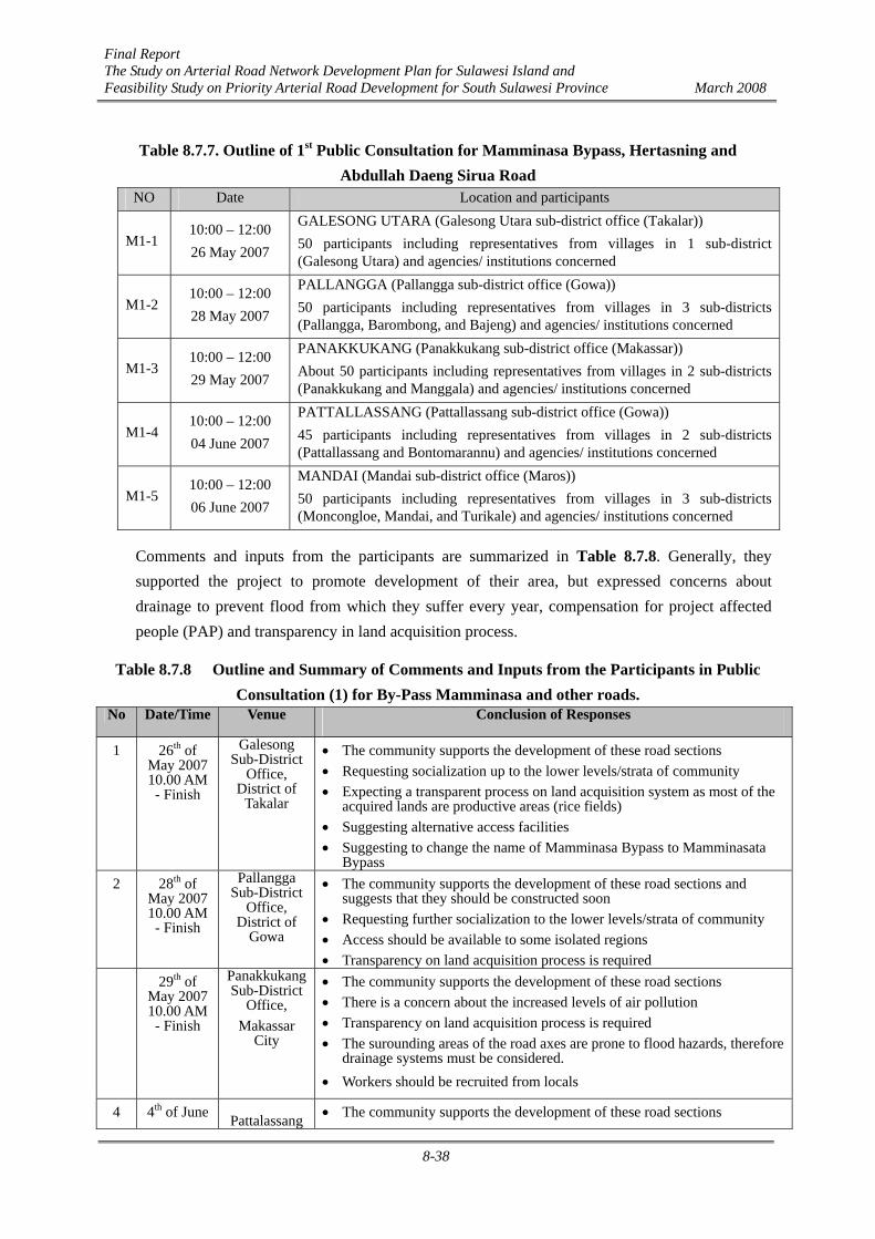
Final Report The Study on Arterial Road Network Development Plan for Sulawesi Island and Feasibility Study on Priority Arterial Road Development for South Sulawesi Province March 2008
8-38
Table 8.7.7. Outline of 1st Public Consultation for Mamminasa Bypass, Hertasning and Abdullah Daeng Sirua Road
NO Date Location and participants
M1-1 10:00 – 12:00 26 May 2007
GALESONG UTARA (Galesong Utara sub-district office (Takalar)) 50 participants including representatives from villages in 1 sub-district (Galesong Utara) and agencies/ institutions concerned
M1-2 10:00 – 12:00 28 May 2007
PALLANGGA (Pallangga sub-district office (Gowa)) 50 participants including representatives from villages in 3 sub-districts (Pallangga, Barombong, and Bajeng) and agencies/ institutions concerned
M1-3 10:00 – 12:00 29 May 2007
PANAKKUKANG (Panakkukang sub-district office (Makassar)) About 50 participants including representatives from villages in 2 sub-districts (Panakkukang and Manggala) and agencies/ institutions concerned
M1-4 10:00 – 12:00 04 June 2007
PATTALLASSANG (Pattallassang sub-district office (Gowa)) 45 participants including representatives from villages in 2 sub-districts (Pattallassang and Bontomarannu) and agencies/ institutions concerned
M1-5 10:00 – 12:00 06 June 2007
MANDAI (Mandai sub-district office (Maros)) 50 participants including representatives from villages in 3 sub-districts (Moncongloe, Mandai, and Turikale) and agencies/ institutions concerned
Comments and inputs from the participants are summarized in Table 8.7.8. Generally, they supported the project to promote development of their area, but expressed concerns about drainage to prevent flood from which they suffer every year, compensation for project affected people (PAP) and transparency in land acquisition process.
Table 8.7.8 Outline and Summary of Comments and Inputs from the Participants in Public Consultation (1) for By-Pass Mamminasa and other roads.
No Date/Time Venue Conclusion of Responses
1 26th of May 2007 10.00 AM - Finish
Galesong Sub-District
Office, District of
Takalar
• The community supports the development of these road sections • Requesting socialization up to the lower levels/strata of community • Expecting a transparent process on land acquisition system as most of the
acquired lands are productive areas (rice fields) • Suggesting alternative access facilities • Suggesting to change the name of Mamminasa Bypass to Mamminasata
Bypass 2 28th of
May 2007 10.00 AM - Finish
Pallangga Sub-District
Office, District of
Gowa
• The community supports the development of these road sections and suggests that they should be constructed soon
• Requesting further socialization to the lower levels/strata of community • Access should be available to some isolated regions • Transparency on land acquisition process is required
29th of May 2007 10.00 AM - Finish
Panakkukang Sub-District
Office, Makassar
City
• The community supports the development of these road sections • There is a concern about the increased levels of air pollution • Transparency on land acquisition process is required • The surounding areas of the road axes are prone to flood hazards, therefore
drainage systems must be considered. • Workers should be recruited from locals
4 4th of June Pattalassang • The community supports the development of these road sections

Final Report The Study on Arterial Road Network Development Plan for Sulawesi Island and Feasibility Study on Priority Arterial Road Development for South Sulawesi Province March 2008
8-39
2007 10.00 AM - Finish
Sub-District Office,
District of Gowa
• Transparency on land acquisition process is required • There are concerns about potential flood hazard after completion of road
construction , therefore good drainage facilities should be provided. • Suggesting to provide alternative access roads
5 6th of June 2007
10.00 AM - Finish
Mandai Sub-District
Office, District of
Maros
• The community supports the development of these road sections • There are concerns about potential flood after completion of road
construction, therefore good drainage facilities should be provided. • The community still has trauma on land acquisition process under the
airport development project and requests a transparent process for land acquisition for this road development project.
• Suggesting to provide alternative access roads • Requesting to construct crossing bridges for pedestrians • The community is concerned about some existing trees to be removed.
Table 8.7.9 Relations of Suggestions and Inputs at Public Consultation (1) among Sub-districts
Issue
Location A. L
and
Acq
uisi
ton
B. D
rain
age
C. L
ocal
Lab
our
D. S
ocia
lizat
ion
E. A
ltern
ativ
e R
oute
s
F. O
pen
Are
a
G.
Tran
spor
tatio
n
H. G
reen
Lin
es
I. Si
dew
alks
and
Ze
bra
cros
s
1. Galesong Utara Kab. Takalar (Mamminasa Bypass)
○
○
○
○
2. Pallangga Kab. Gowa (Mamminasa Bypass)
○
○
○
○
○
○
3. Panakkukang Kota Makassar (Dg. Sirua)
○
○ ○
○
4. Pattalassang Kab. Gowa (Hertasning)
○
○
○
5. Mandai Kabupaten Maros (Mamminasa Bypass)
○
○ ○
○ ○
○
2) Public Consultation (2)
Public Consultation (2) for the Mamminasa Bypass, Hertasning and Abdullah Daeng Sirua Road was conducted on September 7th, 2007. The consultation meeting was facilitated by Bapedalda South Sulawesi in the form of AMDAL Appraisal Technical Committee Meeting. Participants to the meeting included permanent members, Technical Team and temporary members, related stakeholders and local community. There were 45 participants.

Final Report The Study on Arterial Road Network Development Plan for Sulawesi Island and Feasibility Study on Priority Arterial Road Development for South Sulawesi Province March 2008
8-40
All the inputs, written and verbal, were compiled by Bapedalda Secretariat and provided to the EIA Consultant, for reference in TOR revision. TOR was approved by the Technical Committee and confirmed by the Decree No. 660/781/II/Bapedalda on EIA TOR Approval, dated October 11th, 2007.
3) Public Consultation (3)
Public Consultation (3) was conducted by the Study Team to fulfill the requirements of the JICA Guidelines. The consultation meeting was held on September 11th, 2007, and attended by 112 participants from 4 related Regencies/cities, and agencies concerned from local and central governments.
4) Public Consultation (4)
Public Consultation (4) was conducted on November 27 th, 2007. The Draft Final Report is was presented at the AMDAL Committee Meeting.
Table 8.7.10 Outline and Summary of Comments and Inputs from Participants in Public Consultation (4) for Mamminasa By-Pass, Hertasning and Sirua Road
Date: 27 November 2007 Place: Meeting room of BAPEDALDA South Sulawesi Province
Participants: 50 participants from AMDAL Committee/Appraisal team members including representatives from the project area
Summary of Comments and Inputs form Participants ‑ Change of road name of Hertasning to Aorepala ‑ Update of the population rate and number of households referring to the latest statistics, and correction
of the rainfall rate ‑ More detaited elaboration on the quarry sites plan ‑ Highlighting of the importance of drainage in the preparation stage ‑ Study on land acquisition is important and description of land acquisition area by sub-district ‑ Estimate of the value of land acquisition and buildings to be displaced ‑ Description of the standard use for water quality ‑ Adding the source of data and name of laboratory ‑ Clarification on the number of respondents related to the length of roads
Final Report The Study on Arterial Road Network Development Plan for Sulawesi Island and Feasibility Study on Priority Arterial Road Development for South Sulawesi Province March 2008
8-41
8.8 Summary of Final EIA Documents for Trans-Sulawesi Road Mamminasata Section
8.8.1 Environmental Category and Draft EIA (AMDAL) Report
The Trans-Sulawesi Road Mamminasata Section was classified into Category A in accordance with both the JICA and JBIC Guidelines as it is likely to have significant adverse environmental impacts related to involuntary resettlement. On the other hand, positive impacts are anticipated on improvement of accessibility to markets, accessibility to various public utilities, increase in job opportunities. EIA (AMDAL) was conducted in accordance with the Japanese Guidelines and Indonesian law/regulations and its Draft Final Report has been shortly completed. This is a summary of EIA (AMDAL) for the Trans-Sulawesi Road Mamminasata Section including environmental management and monitoring plans.
Environmental Impact Analysis ‑ Study approach, main and purpose ‑ Scope of study ‑ Components of study method ‑ Activity plan ‑ Environmental components and conditions ‑ Predicted significant impacts ‑ Evaluation of significant impacts ‑ Recommended Mitigation Measures
Environmental Management Plan (RKL) ‑ Environmental management purpose ‑ Environmental management approach ‑ Environmental management plan
Environmental Monitoring Plan (RPL) ‑ Environmental monitoring purpose and activities ‑ Environmental monitoring plan
The Report also includes recommended action plans required for the project implementation preparation and external financing arrangement.
8.8.2 Physical Environment (Natural Environment)
(1) Present Condition
a) Air Pollution
The ambient air along the project road is not really polluted at present except for the presence of total suspended particulate (TSP) such as dust in and around the street. Therefore, at the target year (2023) the air conditions will be changed considerably by exhaust from the vehicles along the
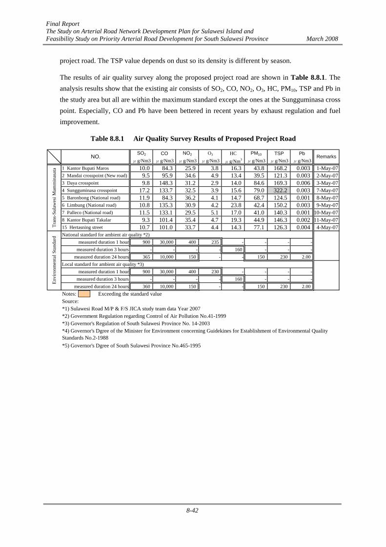
Final Report The Study on Arterial Road Network Development Plan for Sulawesi Island and Feasibility Study on Priority Arterial Road Development for South Sulawesi Province March 2008
8-42
project road. The TSP value depends on dust so its density is different by season.
The results of air quality survey along the proposed project road are shown in Table 8.8.1. The analysis results show that the existing air consists of SO2, CO, NO2, O3, HC, PM10, TSP and Pb in the study area but all are within the maximum standard except the ones at the Sungguminasa cross point. Especially, CO and Pb have been bettered in recent years by exhaust regulation and fuel improvement.
Table 8.8.1 Air Quality Survey Results of Proposed Project Road
SO2 CO NO2 O3 HC PM10 TSP Pbμg/Nm3 μg/Nm3 μg/Nm3 μg/Nm3 μg/Nm3 μg/Nm3 μg/Nm3 μg/Nm3
1 Kantor Bupati Maros 10.0 84.3 25.9 3.8 16.3 43.8 168.2 0.003 1-May-072 Mandai crosspoint (New road) 9.5 95.9 34.6 4.9 13.4 39.5 121.3 0.003 2-May-073 Daya crosspoint 9.8 148.3 31.2 2.9 14.0 84.6 169.3 0.006 3-May-074 Sungguminasa crosspoint 17.2 133.7 32.5 3.9 15.6 79.0 322.2 0.003 7-May-075 Baronbong (National road) 11.9 84.3 36.2 4.1 14.7 68.7 124.5 0.001 8-May-076 Limbung (National road) 10.8 135.3 30.9 4.2 23.8 42.4 150.2 0.003 9-May-077 Palleco (National road) 11.5 133.1 29.5 5.1 17.0 41.0 140.3 0.001 10-May-078 Kantor Bupati Takalar 9.3 101.4 35.4 4.7 19.3 44.9 146.3 0.002 11-May-0715 Hertasning street 10.7 101.0 33.7 4.4 14.3 77.1 126.3 0.004 4-May-07National standard for ambient air quality *2)
measured duration 1 hour 900 30,000 400 235 - - - -measured duration 3 hours - - - - 160 - - -
measured duration 24 hours 365 10,000 150 - - 150 230 2.00Local standard for ambient air quality *3)
measured duration 1 hour 900 30,000 400 230 - - - -measured duration 3 hours - - - - 160 - - -
measured duration 24 hours 360 10,000 150 - - 150 230 2.00Notes: Exceeding the standard valueSource:*1) Sulawesi Road M/P & F/S JICA study team data Year 2007*2) Government Regulation regarding Control of Air Pollution No.41-1999*3) Governor's Regulation of South Sulawesi Province No. 14-2003
*5) Governor's Dgree of South Sulawesi Province No.465-1995
*4) Governor's Dgree of the Minister for Environment concerning Guidekines for Establishment of Environmental QualityStandards No.2-1988
Envi
ronm
enta
l Sta
ndar
d
RemarksNO.
Tran
s-Su
law
esi M
amm
inas
ata

Final Report The Study on Arterial Road Network Development Plan for Sulawesi Island and Feasibility Study on Priority Arterial Road Development for South Sulawesi Province March 2008
8-43
Figure 8.8.1 shows the location of on-site survey points and areas regarding air quality, noise, water quality, flora and fauna.
Figure 8.8.1 On-site Survey Points (Trans-Sulawesi Road Mamminasata
Section)

Final Report The Study on Arterial Road Network Development Plan for Sulawesi Island and Feasibility Study on Priority Arterial Road Development for South Sulawesi Province March 2008
8-44
b) Noise Level
Table 8.8.2 is a summary of noise measurements along the Project road. All noise levels at daytime exceed the Environmental Standard in the commercial and service area. The noise at the night time is mostly less than the admissible limit. The maximum noise level is over 80 dB(A) at the Daya cross point and the daily average at the Sungguminasa cross point exceeds 70 dB(A).
The assumed reasons for high noise level are that the traffic volume of motorcycles is huge and horn is used too frequently in the present driving custom.
Table 8.8.2 Noise Level Survey Result of Proposed Project Road
daytime night
1 Kantor Bupati Maros 72.8 66.2 69.5 77.2 1-May-072 Mandai crosspoint (New road) 71.9 54.3 63.1 75.8 2-May-073 Daya crosspoint 75.5 63.8 69.7 80.8 3-May-074 Sungguminasa crosspoint 76.2 66.5 71.3 79.3 7-May-075 Baronbong (National road) 70.9 62.3 66.6 79.2 8-May-076 Limbung (National road) 71.9 59.0 65.5 79.4 9-May-077 Palleko (National road) 71.3 54.4 62.8 79.6 10-May-078 Kantor Bupati Takalar 70.3 56.0 63.2 76.8 11-May-0715 Hertasning street 74.4 59.9 67.2 79.0 4-May-07
Area classification National Provincial Commercial and Service 70.0 70.0 Industry 70.0 70.0 Office Buildings and Commercial 65.0 65.0 Recreation 70.0 65.0 Government and Public Facilities 60.0 60.0 Housing and Settlement 55.0 55.0 Green Open Space 50.0 50.0
Notes: Exceeding the standard value (Maximum Environmental Standard: 70dB(A))Source : Sulawesi Road M/P & F/S JICA study team data Year 2007
Envi
ronm
enta
l Sta
ndar
d
L50
Tran
s-Su
law
esi M
amm
inas
ata
Average Remarks(data)NO. Max L50
c) Water Pollution
The results of quality tests of water sampled along the Project road are summarized in Table 8.8.3. Several values exceed the River Water Quality Standards.
The TSS density is relatively high as a characteristic of Indonesia. BOD5 values show a high density for the reason that the sampling points are located relatively near the high population density area.

Final Report The Study on Arterial Road Network Development Plan for Sulawesi Island and Feasibility Study on Priority Arterial Road Development for South Sulawesi Province March 2008
8-45
Table 8.8.3 Water Level Survey Result of Proposed Project Road 1 2 3 4 5 6
24-May-07 25-May-07 24-May-07
Class I Class II Class III Class IV Tallo RiverPDAM canal in
Makassar Drainage canal Jeneberang river Gamanti river Irrigation canal
Physical :Temperature ±3℃ ±3℃ ±3℃ ±5℃ ℃ 30 29 29 30 30 30Color (-) (-) (-) (-) TCU 6 5 27 12 25 30Total Suspended Solid (TSS) 50 50 400 400 mg/l 12.8 3.6 6 69.6 696 312Electric Conductivity (-) (-) (-) (-) μS/cm 506 111 3,802 92 123 74ChemicalpH 6-9 6-9 6-9 5-9 - 7.0 7.9 7.1 7.0 7.0 7.0BOD5 2 3 6 12 mg/l 2.42 3.78 5.670 4.589 2.174 3.780COD 10 25 50 100 mg/l 2.98 4.94 7.41 5.65 2.68 4.94Disolved Oxigen (DO) 6 4 3 0 mg/l 7.974 7.991 6.300 7.749 7.350 7.140Phosphorus (P) 0.2 0.2 1.0 5.0 mg/l 0.003 0.006 0.004 0.005 0.006 0.003Nitrate (NO3-N) 10 10 20 20 mg/l 0.002 ttd 0.12 0.001 0.001 0.001Amonium (NH3-N) 0.5 (-) (-) (-) mg/l 0.031 0.009 2.4 0.019 0.028 0.019Cadmium (Cd ) 0.01 0.01 0.01 0.01 mg/l ttd ttd ttd ttd ttd ttdChromium (Cr6+ ) 0.05 0.1 0.1 1.0 mg/l ttd ttd ttd ttd ttd ttdCupper ( Cu) 0.02 0.02 0.02 0.20 mg/l ttd ttd ttd ttd ttd ttdIron ( Fe ) 0.30 (-) (-) (-) mg/l 0.059 0.171 0.061 0.457 0.324 0.537Lead (Pb) 0.03 0.03 0.03 1.0 mg/l ttd ttd ttd ttd ttd ttdMangan ( Mn ) 0.10 (-) (-) (-) mg/l ttd ttd ttd ttd ttd ttdMercury (Hg) 0.001 0.002 0.002 0.005 mg/l ttd ttd ttd ttd ttd ttdZinc (Zn) 0.05 0.05 0.10 2.00 mg/l 0.0018 ttd ttd ttd ttd ttdChlouride (Cl-) 600 (-) (-) (-) mg/l 133.92 4.11 70.66 9.04 4.11 4.93Cyanide (CN) 0.02 0.02 0.02 (-) mg/l ttd ttd ttd ttd ttd ttdFluorine (F-) 0.50 1.50 1.50 (-) mg/l ttd ttd ttd ttd ttd ttdNitrite (NO2-N) 0.06 0.06 0.06 (-) mg/l ttd ttd ttd ttd ttd ttdSulphate (SO4) 400 (-) (-) (-) mg/l 3.2 0.97 2.7 4.1 1.34 1.6Free Chlourine ( Cl2 ) 0.03 0.03 0.03 (-) mg/l 0.0036 0.0009 0.0018 0.0036 0.0018 0.0036Hydrogen Sulphine (H2S
- ) 0.002 0.002 0.002 (-) mg/l 0.002 ttd 0.005 0.002 0.005 0.004Calcium Carbonate (CaCO3) (-) (-) (-) (-) mg/l 44.04 44.04 130.12 28.03 40.04 46.04Calcium (Ca) (-) (-) (-) (-) mg/l 17.64 17.64 36.07 11.22 16.03 18.44Organic ChemicalMineral oil 0.6 0.8 1.0 (-) mg/l ttd 0.8 ttd 1.2 0.8 0.8Detergent 0.1 0.1 0.1 (-) mg/l ttd ttd ttd ttd ttd ttdPhenol compounds 0.001 0.001 0.001 (-) mg/l ttd ttd ttd ttd ttd ttdBacteriology :Fecal Coliform 100 1,000 2,000 2,000 MPN/100ml 0 0 0 0 0 0Total Coliforms 1,000 5,000 10,000 10,000 MPN/100ml 110 17 17 70 49 22
Notes:
Source : Mamminasata JICA study team data Year 2006Remarks: ttd means below the limit value of quantitative analysis
Parameters Unit
Governmental RegulationsNo.82-2001
Exceeding the standard
d) Biology (Flora and Fauna)
The scope of works for Sections A (Maros - Makassar) and D (Gowa - Takalar) consists of widening of the existing road. The proposed project road will pass through both semi urban and rural areas. Sections B and C are new road construction. Section C passes through urban and semi urban areas. Section C starts in the urban area but passes mostly in paddy fields after crossing the Jeneberang River.
i) Section A
During the field reconnaissance around small rivers, such birds like waterfowls that are mainly egrets, herons were observed. The existing species are common ones in the rural area of South Sulawesi. No large mammals were observed in the project area.
The vegetation consists mostly of planted species along the existing road such as mango trees, coconuts, bananas and other fruit trees. It seems that the precious vegetation species listed or designated in the standards of Indonesia do not exist around the project area.
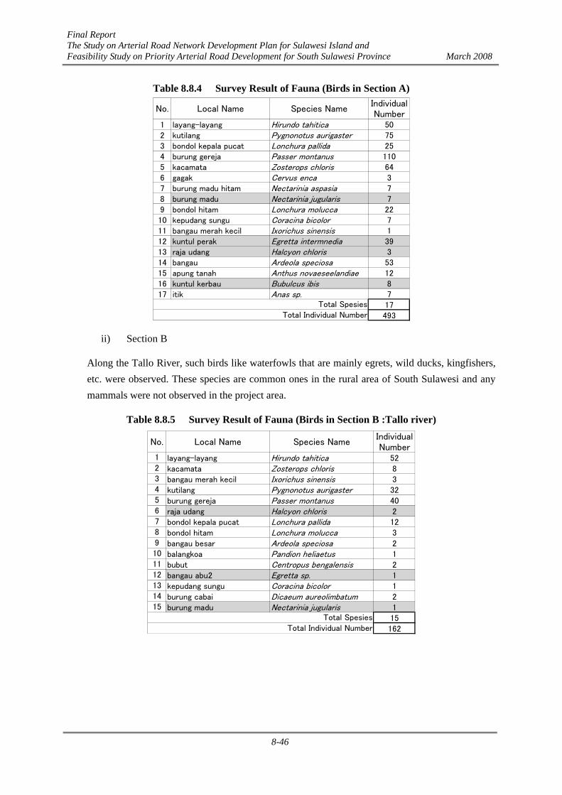
Final Report The Study on Arterial Road Network Development Plan for Sulawesi Island and Feasibility Study on Priority Arterial Road Development for South Sulawesi Province March 2008
8-46
Table 8.8.4 Survey Result of Fauna (Birds in Section A)
No. Local Name Species NameIndividualNumber
1 layang-layang Hirundo tahitica 502 kutilang Pygnonotus aurigaster 753 bondol kepala pucat Lonchura pallida 254 burung gereja Passer montanus 1105 kacamata Zosterops chloris 646 gagak Cervus enca 37 burung madu hitam Nectarinia aspasia 78 burung madu Nectarinia jugularis 79 bondol hitam Lonchura molucca 2210 kepudang sungu Coracina bicolor 711 bangau merah kecil Ixorichus sinensis 112 kuntul perak Egretta intermnedia 3913 raja udang Halcyon chloris 314 bangau Ardeola speciosa 5315 apung tanah Anthus novaeseelandiae 1216 kuntul kerbau Bubulcus ibis 817 itik Anas sp. 7
17493
Total SpesiesTotal Individual Number
ii) Section B
Along the Tallo River, such birds like waterfowls that are mainly egrets, wild ducks, kingfishers, etc. were observed. These species are common ones in the rural area of South Sulawesi and any mammals were not observed in the project area.
Table 8.8.5 Survey Result of Fauna (Birds in Section B :Tallo river)
No. Local Name Species NameIndividualNumber
1 layang-layang Hirundo tahitica 522 kacamata Zosterops chloris 83 bangau merah kecil Ixorichus sinensis 34 kutilang Pygnonotus aurigaster 325 burung gereja Passer montanus 406 raja udang Halcyon chloris 27 bondol kepala pucat Lonchura pallida 128 bondol hitam Lonchura molucca 39 bangau besar Ardeola speciosa 210 balangkoa Pandion heliaetus 111 bubut Centropus bengalensis 212 bangau abu2 Egretta sp. 113 kepudang sungu Coracina bicolor 114 burung cabai Dicaeum aureolimbatum 215 burung madu Nectarinia jugularis 1
15162
Total SpesiesTotal Individual Number

Final Report The Study on Arterial Road Network Development Plan for Sulawesi Island and Feasibility Study on Priority Arterial Road Development for South Sulawesi Province March 2008
8-47
Table 8.8.6 Survey Result of Fauna (Birds in Section B)
No. Local Name Species NameIndividualNumber
1 burung gereja Passer montanus 282 kutilang Pygnonotus aurigaster 103 burung madu Nectarinia jugularis 24 kacamata Zosterops chloris 15 layang-layang Hirundo tahitica 726 bangau putih Egretta intermedia 87 bangau abu2 Ardeola speciosa 28 bondol kepala pucat Lonchura pallida 159 bondol kepala hitam Lonchura molucca 210 bangau merah kecil Ixorichus sinensis 211 raja udang Halcyon chloris 112 bondol hitam Lonchura molucca 213 bangau besar Ardeola speciosa 214 bubut Centropus bengalensis 2
14149
Total SpesiesTotal Individual Number
The vegetation consists of mostly planted species in/along the proposed road alignment. Nipah palms grow along the Tallo River and these contribute to the purification of water. It seems that the vegetation species that are found in/around this section are not the essential ones to be protected by regulations.
In addition, though on-site survey results or data are not available on the freshwater aquatic species in the Tallo River and any drainage canal in this area, it is considered no protective or endangered species exist. However, if some endemic and/or protected species of flora and fauna are found during the design or construction phases, especially in/around the Tallo River, it is important to confirm such species and to report to authorities concerned. In addition, proper countermeasures and positive protection programs should be implemented to minimize negative effects on the existing environment.
iii) Section C
It was not reported at the previous investigation and on-site survey that endemic and protected species of flora and fauna inhabit in/around the project site. Only common species of flora and fauna were confirmed by on-site survey in this project site. Precious diversity of biota also was not reported and discovered.
If during the construction phase some endemic and/or protected species of flora and fauna are found in the project site, it is necessary to confirm such species and report to authorities concerned.

Final Report The Study on Arterial Road Network Development Plan for Sulawesi Island and Feasibility Study on Priority Arterial Road Development for South Sulawesi Province March 2008
8-48
Table 8.8.7 Survey Result of Fauna (Birds in Section C)
No. Local Name Species NameIndividualNumber
1 layang-layang Hirundo tahitica 962 kutilang Pygnonotus aurigaster 263 kacamata Zosterops chloris 124 raja udang Halcyon chloris 25 bondol kepala pucat Lonchura pallida 166 bangau Ardeola speciosa 77 burung gereja Passer montanus 578 burung madu Nectarinia aspasia 49 bondol kepala hitam Lonchura molucca 1110 kepudang sungu Coracina bicolor 311 bondol hitam Lonchura molucca 712 kuntul perak Egretta intermnedia 3
12244
Total SpesiesTotal Individual Number
iv) Section D
The project road passes through the existing road and irrigated agricultural areas in Gowa and Takalar Regencies. The flora and fauna species observed are the common ones and no species which require protection were found.
Sparrows, muias and finches were observed in the plain during the field reconnaissance. No endemic mammals of conservation species were seen.
The vegetation consists of mostly hilly land species and cultivation species are paddy and corn (jagung). The existing trees are common kinds of fruit trees.
Table 8.8.8 Survey Result of Fauna (Birds in Section D)
No. Local Name Species NameIndividualNumber
1 bondol kepala pucat Lonchura pallida 262 kepudang Lonchura molucca 33 burung gereja Passer montanus 214 burung madu Nectarinia aspasia 55 kutilang Pygnonotus aurigaster 46 layang-layang Hirundo tahitica 467 kapinis laut Apus pacificus 68 bondol kepala hitam Lonchura molucca 49 raja udang Halcyon chloris 110 kacamata Zosterops chloris 911 bangau abu2 Ardeola speciosa 1
9
126
Total Spesies
Total Individual Number
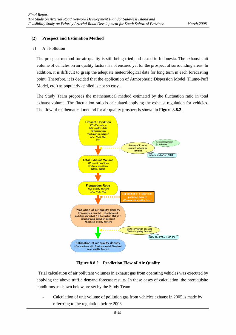
Final Report The Study on Arterial Road Network Development Plan for Sulawesi Island and Feasibility Study on Priority Arterial Road Development for South Sulawesi Province March 2008
8-49
(2) Prospect and Estimation Method
a) Air Pollution
The prospect method for air quality is still being tried and tested in Indonesia. The exhaust unit volume of vehicles on air quality factors is not ensured yet for the prospect of surrounding areas. In addition, it is difficult to grasp the adequate meteorological data for long term in each forecasting point. Therefore, it is decided that the application of Atmospheric Dispersion Model (Plume-Puff Model, etc.) as popularly applied is not so easy.
The Study Team proposes the mathematical method estimated by the fluctuation ratio in total exhaust volume. The fluctuation ratio is calculated applying the exhaust regulation for vehicles. The flow of mathematical method for air quality prospect is shown in Figure 8.8.2.
Present Condition *Traffic volume*Air quality data*Urbanization
*Exhaust regulation(CO, NOx, HC)
etc.
Setting of Exhaustgas unit volume by
vehicles
before and after 2003
Total Exhaust Volume *Present condition*Future condition
(2015, 2023)
Fluctuation Ratio *Air quality factors
(CO, NOx, HC)
Multi correlation analysis(Each air quality factors)
Supposition of backgroundpollution density
(Present air quality data)
Exhaust regulationin Indonesia
Prediction of air quality density((Present air quality) - (Background
pollution density)) X (Fluctuation Ratio) +(Background pollution density)
*Each air quality factors
SO2, O3, PM10, TSP, Pb
Estimation of air quality density*Comparison with Environmental Standard
in air quality factors
Figure 8.8.2 Prediction Flow of Air Quality
Trial calculation of air pollutant volumes in exhaust gas from operating vehicles was executed by applying the above traffic demand forecast results. In these cases of calculation, the prerequisite conditions as shown below are set by the Study Team.
- Calculation of unit volume of pollution gas from vehicles exhaust in 2005 is made by referrring to the regulation before 2003
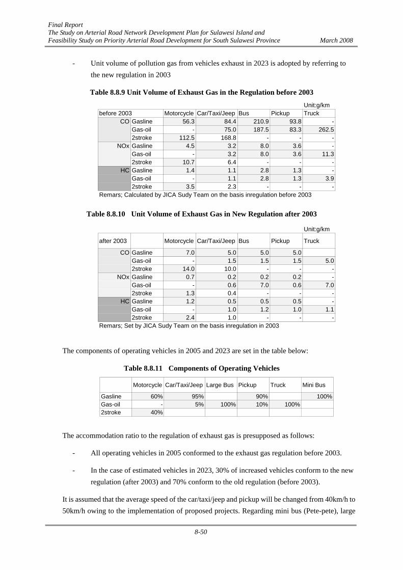
Final Report The Study on Arterial Road Network Development Plan for Sulawesi Island and Feasibility Study on Priority Arterial Road Development for South Sulawesi Province March 2008
8-50
- Unit volume of pollution gas from vehicles exhaust in 2023 is adopted by referring to the new regulation in 2003
Table 8.8.9 Unit Volume of Exhaust Gas in the Regulation before 2003
Unit:g/kmbefore 2003 Motorcycle Car/Taxi/Jeep Bus Pickup Truck
CO Gasline 56.3 84.4 210.9 93.8 -Gas-oil - 75.0 187.5 83.3 262.52stroke 112.5 168.8 - - -
NOx Gasline 4.5 3.2 8.0 3.6 -Gas-oil - 3.2 8.0 3.6 11.32stroke 10.7 6.4 - - -
HC Gasline 1.4 1.1 2.8 1.3 -Gas-oil - 1.1 2.8 1.3 3.92stroke 3.5 2.3 - - -
Remars; Calculated by JICA Sudy Team on the basis inregulation before 2003
Table 8.8.10 Unit Volume of Exhaust Gas in New Regulation after 2003
Unit:g/km
after 2003 Motorcycle Car/Taxi/Jeep Bus Pickup Truck
CO Gasline 7.0 5.0 5.0 5.0Gas-oil - 1.5 1.5 1.5 5.02stroke 14.0 10.0 - - -
NOx Gasline 0.7 0.2 0.2 0.2 -Gas-oil - 0.6 7.0 0.6 7.02stroke 1.3 0.4 - - -
HC Gasline 1.2 0.5 0.5 0.5 -Gas-oil - 1.0 1.2 1.0 1.12stroke 2.4 1.0 - - -
Remars; Set by JICA Sudy Team on the basis inregulation in 2003
The components of operating vehicles in 2005 and 2023 are set in the table below:
Table 8.8.11 Components of Operating Vehicles
Motorcycle Car/Taxi/Jeep Large Bus Pickup Truck Mini Bus
Gasline 60% 95% 90% 100%Gas-oil - 5% 100% 10% 100%2stroke 40%
The accommodation ratio to the regulation of exhaust gas is presupposed as follows:
- All operating vehicles in 2005 conformed to the exhaust gas regulation before 2003.
- In the case of estimated vehicles in 2023, 30% of increased vehicles conform to the new regulation (after 2003) and 70% conform to the old regulation (before 2003).
It is assumed that the average speed of the car/taxi/jeep and pickup will be changed from 40km/h to 50km/h owing to the implementation of proposed projects. Regarding mini bus (Pete-pete), large
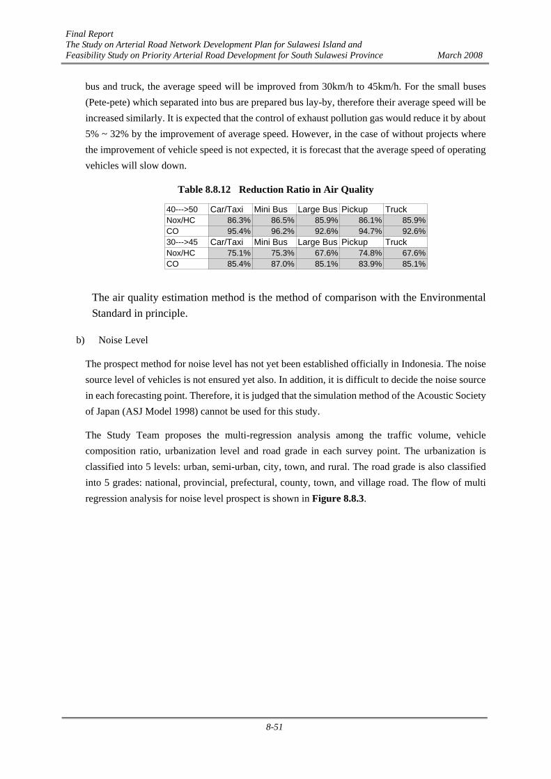
Final Report The Study on Arterial Road Network Development Plan for Sulawesi Island and Feasibility Study on Priority Arterial Road Development for South Sulawesi Province March 2008
8-51
bus and truck, the average speed will be improved from 30km/h to 45km/h. For the small buses (Pete-pete) which separated into bus are prepared bus lay-by, therefore their average speed will be increased similarly. It is expected that the control of exhaust pollution gas would reduce it by about 5% ~ 32% by the improvement of average speed. However, in the case of without projects where the improvement of vehicle speed is not expected, it is forecast that the average speed of operating vehicles will slow down.
Table 8.8.12 Reduction Ratio in Air Quality
40--->50 Car/Taxi Mini Bus Large Bus Pickup TruckNox/HC 86.3% 86.5% 85.9% 86.1% 85.9%CO 95.4% 96.2% 92.6% 94.7% 92.6%30--->45 Car/Taxi Mini Bus Large Bus Pickup TruckNox/HC 75.1% 75.3% 67.6% 74.8% 67.6%CO 85.4% 87.0% 85.1% 83.9% 85.1%
The air quality estimation method is the method of comparison with the Environmental Standard in principle.
b) Noise Level
The prospect method for noise level has not yet been established officially in Indonesia. The noise source level of vehicles is not ensured yet also. In addition, it is difficult to decide the noise source in each forecasting point. Therefore, it is judged that the simulation method of the Acoustic Society of Japan (ASJ Model 1998) cannot be used for this study.
The Study Team proposes the multi-regression analysis among the traffic volume, vehicle composition ratio, urbanization level and road grade in each survey point. The urbanization is classified into 5 levels: urban, semi-urban, city, town, and rural. The road grade is also classified into 5 grades: national, provincial, prefectural, county, town, and village road. The flow of multi regression analysis for noise level prospect is shown in Figure 8.8.3.

Final Report The Study on Arterial Road Network Development Plan for Sulawesi Island and Feasibility Study on Priority Arterial Road Development for South Sulawesi Province March 2008
8-52
Coefficient*Motorcycle ratio 56.424978*Small vehicle ratio 69.977782*Large vehicle ratio 64.645546*Total traffic volume 0.002306*Urbanization 0.958419*Road grade 0.871556Remaks: Intercept coefficient = 0
Present Condition *Traffic volume
*Vehicle composition*Noise level data
*Urbanization*Road grade
etc.
Urban, Semi-urban, City,Town, Rural
: 5 grade
Mathematical Analysis *Multi regression analysis
Supposition of coeffient *Traffic volume factor
*Urbanization*Road grade
National, Provincial, City andPrefectural, County, Townand Village: 5 grade
Prediction of noise level *Future traffic volume
(Motorcycle, Small vehicle, Large veicleRatio, Urbanization and Road grade)
Estimation of noise level*Comparison with Environmental Standard
in roadside
Figure 8.8.3 Prediction Flow of Noise Level
The result of multi-regression analysis among motorcycle ratio, small vehicle ratio, large vehicle ratio, traffic volume, urbanization level and road grade is shown in Table 8.8.13. Especially, the corrected multi-correlation of determination that shows the reliance on prediction model is estimated to be over 99 %. The coefficient for each factor is shown in Table 8.8.14.
Table 8.8.13 Multi-Regression Analysis Results for Noise Level
Regression Analysis ResultMulti Correlation Coefficient (R) 0.9972Multi Correlation of Determination (R2) 0.9945Corrected Multi Correlation of Determination (R2) 0.9906Standard Error of the Regression Coefficient 5.1098Number of data 272
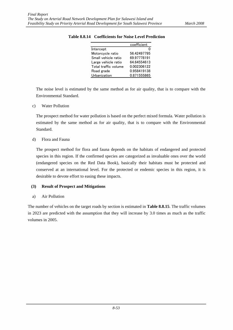
Final Report The Study on Arterial Road Network Development Plan for Sulawesi Island and Feasibility Study on Priority Arterial Road Development for South Sulawesi Province March 2008
8-53
Table 8.8.14 Coefficients for Noise Level Prediction
coefficientIntercept 0Motorcycle ratio 56.42497795Small vehicle ratio 69.97778191Large vehicle ratio 64.64554613Total traffic volume 0.002306122Road grade 0.958419138Urbanization 0.871555865
The noise level is estimated by the same method as for air quality, that is to compare with the Environmental Standard.
c) Water Pollution
The prospect method for water pollution is based on the perfect mixed formula. Water pollution is estimated by the same method as for air quality, that is to compare with the Environmental Standard.
d) Flora and Fauna
The prospect method for flora and fauna depends on the habitats of endangered and protected species in this region. If the confirmed species are categorized as invaluable ones over the world (endangered species on the Red Data Book), basically their habitats must be protected and conserved at an international level. For the protected or endemic species in this region, it is desirable to devote effort to easing these impacts.
(3) Result of Prospect and Mitigations
a) Air Pollution
The number of vehicles on the target roads by section is estimated in Table 8.8.15. The traffic volumes in 2023 are predicted with the assumption that they will increase by 3.0 times as much as the traffic volumes in 2005.
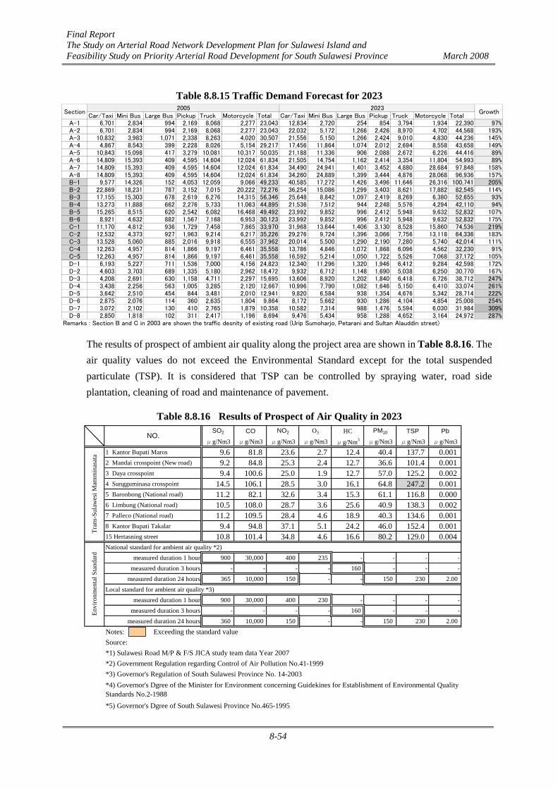
Final Report The Study on Arterial Road Network Development Plan for Sulawesi Island and Feasibility Study on Priority Arterial Road Development for South Sulawesi Province March 2008
8-54
Table 8.8.15 Traffic Demand Forecast for 2023
Car/Taxi Mini Bus Large Bus Pickup Truck Motorcycle Total Car/Taxi Mini Bus Large Bus Pickup Truck Motorcycle TotalA-1 6,701 2,834 994 2,169 8,068 2,277 23,043 12,834 2,720 254 854 3,794 1,934 22,390 97%A-2 6,701 2,834 994 2,169 8,068 2,277 23,043 22,032 5,172 1,266 2,426 8,970 4,702 44,568 193%A-3 10,832 3,983 1,071 2,338 8,263 4,020 30,507 21,556 5,150 1,266 2,424 9,010 4,830 44,236 145%A-4 4,867 8,543 399 2,228 8,026 5,154 29,217 17,456 11,864 1,074 2,012 2,694 8,558 43,658 149%A-5 10,843 15,098 417 3,279 10,081 10,317 50,035 21,188 11,336 906 2,088 2,672 6,226 44,416 89%A-6 14,809 15,393 409 4,595 14,604 12,024 61,834 21,505 14,754 1,162 2,414 3,354 11,804 54,993 89%A-7 14,809 15,393 409 4,595 14,604 12,024 61,834 34,490 24,941 1,401 3,452 4,880 28,684 97,848 158%A-8 14,809 15,393 409 4,595 14,604 12,024 61,834 34,260 24,889 1,399 3,444 4,876 28,068 96,936 157%B-1 9,577 14,326 152 4,053 12,059 9,066 49,233 40,585 17,272 1,426 3,496 11,646 26,316 100,741 205%B-2 22,869 18,231 787 3,152 7,015 20,222 72,276 36,254 15,086 1,299 3,403 8,621 17,882 82,545 114%B-3 17,155 15,303 678 2,619 6,276 14,315 56,346 25,648 8,842 1,097 2,419 8,269 6,380 52,655 93%B-4 13,273 11,888 662 2,276 5,733 11,063 44,895 21,536 7,512 944 2,248 5,576 4,294 42,110 94%B-5 15,265 8,515 620 2,542 6,082 16,468 49,492 23,992 9,852 996 2,412 5,948 9,632 52,832 107%B-6 8,921 4,632 882 1,567 7,168 6,953 30,123 23,992 9,852 996 2,412 5,948 9,632 52,832 175%C-1 11,170 4,812 936 1,729 7,458 7,865 33,970 31,968 13,644 1,406 3,130 8,528 15,860 74,536 219%C-2 12,532 4,373 927 1,963 9,214 6,217 35,226 29,276 9,724 1,396 3,066 7,756 13,118 64,336 183%C-3 13,528 5,060 885 2,016 9,918 6,555 37,962 20,014 5,500 1,290 2,190 7,280 5,740 42,014 111%C-4 12,263 4,957 814 1,866 9,197 6,461 35,558 13,786 4,846 1,072 1,868 6,096 4,562 32,230 91%C-5 12,263 4,957 814 1,866 9,197 6,461 35,558 16,592 5,214 1,050 1,722 5,526 7,068 37,172 105%D-1 6,193 5,227 711 1,536 7,000 4,156 24,823 12,340 11,296 1,320 1,946 6,412 9,284 42,598 172%D-2 4,603 3,703 689 1,335 5,180 2,962 18,472 9,932 6,712 1,148 1,690 5,038 6,250 30,770 167%D-3 4,208 2,691 630 1,158 4,711 2,297 15,695 13,606 8,920 1,202 1,840 6,418 6,726 38,712 247%D-4 3,438 2,256 563 1,005 3,285 2,120 12,667 10,996 7,790 1,082 1,646 5,150 6,410 33,074 261%D-5 3,642 2,510 454 844 3,481 2,010 12,941 9,820 6,584 938 1,354 4,676 5,342 28,714 222%D-6 2,875 2,076 114 360 2,635 1,804 9,864 8,172 5,662 930 1,286 4,104 4,854 25,008 254%D-7 3,072 2,102 130 410 2,765 1,879 10,358 10,582 7,314 988 1,476 5,594 6,030 31,984 309%D-8 2,850 1,818 102 311 2,417 1,196 8,694 9,476 5,434 958 1,288 4,652 3,164 24,972 287%
Remarks : Section B and C in 2003 are shown the traffic desnity of existing road (Urip Sumoharjo, Petarani and Sultan Alauddin street)
2005 2023Section Growth
The results of prospect of ambient air quality along the project area are shown in Table 8.8.16. The air quality values do not exceed the Environmental Standard except for the total suspended particulate (TSP). It is considered that TSP can be controlled by spraying water, road side plantation, cleaning of road and maintenance of pavement.
Table 8.8.16 Results of Prospect of Air Quality in 2023 SO2 CO NO2 O3 HC PM10 TSP Pb
μg/Nm3 μg/Nm3 μg/Nm3 μg/Nm3 μg/Nm3 μg/Nm3 μg/Nm3 μg/Nm31 Kantor Bupati Maros 9.6 81.8 23.6 2.7 12.4 40.4 137.7 0.0012 Mandai crosspoint (New road) 9.2 84.8 25.3 2.4 12.7 36.6 101.4 0.0013 Daya crosspoint 9.4 100.6 25.0 1.9 12.7 57.0 125.2 0.0024 Sungguminasa crosspoint 14.5 106.1 28.5 3.0 16.1 64.8 247.2 0.0015 Baronbong (National road) 11.2 82.1 32.6 3.4 15.3 61.1 116.8 0.0006 Limbung (National road) 10.5 108.0 28.7 3.6 25.6 40.9 138.3 0.0027 Palleco (National road) 11.2 109.5 28.4 4.6 18.9 40.3 134.6 0.0018 Kantor Bupati Takalar 9.4 94.8 37.1 5.1 24.2 46.0 152.4 0.00115 Hertasning street 10.8 101.4 34.8 4.6 16.6 80.2 129.0 0.004National standard for ambient air quality *2)
measured duration 1 hour 900 30,000 400 235 - - - -measured duration 3 hours - - - - 160 - - -
measured duration 24 hours 365 10,000 150 - - 150 230 2.00Local standard for ambient air quality *3)
measured duration 1 hour 900 30,000 400 230 - - - -measured duration 3 hours - - - - 160 - - -
measured duration 24 hours 360 10,000 150 - - 150 230 2.00
Notes: Exceeding the standard valueSource:*1) Sulawesi Road M/P & F/S JICA study team data Year 2007*2) Government Regulation regarding Control of Air Pollution No.41-1999*3) Governor's Regulation of South Sulawesi Province No. 14-2003
*5) Governor's Dgree of South Sulawesi Province No.465-1995
*4) Governor's Dgree of the Minister for Environment concerning Guidekines for Establishment of Environmental QualityStandards No.2-1988
Envi
ronm
enta
l Sta
ndar
dTr
ans-
Sula
wes
i Mam
min
asat
a
NO.

Final Report The Study on Arterial Road Network Development Plan for Sulawesi Island and Feasibility Study on Priority Arterial Road Development for South Sulawesi Province March 2008
8-55
Especially, dust from the construction will be generated in a short period during the land leveling stage (excavation and filling). It can be minimized by applying countermeasures such as sprinkling water. Air pollution caused by operation of construction machines can also be reduced by regular maintenance and efficiently scheduled operation.
During the construction phase, operation of trucks and construction machines will affect air quality conditions. However, the number of such vehicles and machines will be limited, so the environmental impact may be forecast and evaluated based on the planned environmental studies and countermeasures.
For example, the evaluation can be based on the following conditions:
- the number of vehicles is minimized - their tires are washed when they go out from the construction area - construction machines are regularly inspected and monitored - their operation is efficiently planned
In addition, dust from the construction should be regularly monitored and evaluated against the environmental standard.
After the completion of the project, it is necessary to monitor regularly the air conditions caused by the operating vehicles on the road. The air quality condition will deteriorate because it is estimated that the traffic density in 2023 will increase considerably.
For the operation phase, air pollution caused by the vehicles needs to be evaluated. The air quality does not deteriorate simply and immediately at the time of traffic density increase as the main cause of air pollution. It is necessary to investigate the composition of operating vehicles, kind of fuel, exhaust gas quality and so on for unerring anticipation of air quality.
In a long term, the traffic density will be increasing gradually, therefore, regular monitoring, analysis and evaluation are recommended. Environmental buffer zones along the road should be created beforehand to cope with air quality deterioration in the target area, where the population will be concentrated in future.
b) Noise and Vibration
Noise of the construction machines can be reduced by regular maintenance and efficiently scheduled operation. The noise around the construction areas should be monitored so that countermeasures can be taken timely. For example, evaluation should be made on whether the noise impact could be reduced by a proper schedule of the operating hours of construction machines.
The number of vehicles and machines will be limited. Therefore, the environmental impact during the construction phase may be forecast and evaluated based on the planned study and countermeasures against noise and vibration.

Final Report The Study on Arterial Road Network Development Plan for Sulawesi Island and Feasibility Study on Priority Arterial Road Development for South Sulawesi Province March 2008
8-56
Monitoring of noise and vibration along the planned alignment is also necessary for evaluation according to the standard.
After the completion of the project, noise will be caused by the operating vehicles on the road. In the future, as it is guessed that the traffic density will increase certainly, countermeasures are necessary to be planned for the protection of hospitals and schools along the target streets against traffic noise impact.
Noise and vibration generated by operating vehicles need to be studied. However, the noise and vibration level does not become higher simply and immediately at the time of traffic density increase as the main cause. It is necessary to investigate the composition of operating vehicles, noise and vibration level of vehicles and so on for unerring anticipation of noise and vibration.
The result of prospect is shown in Table 8.8.17. Around the intersection of the Perintis road and the Middle Ring Road, Sungguminasa cross point where traffic will be concentrated, it is assumed that the noise level will exceed 80 dB(A).
Table 8.8.17 Results of Prospect of Noise Level in 2023
Car/Taxi Mini Bus Large Bus Pickup Truck Motorcycle TotalA-1 12,834 2,720 254 854 3,794 1,934 22,390 75.4A-2 22,032 5,172 1,266 2,426 8,970 4,702 44,568 77.0A-3 21,556 5,150 1,266 2,424 9,010 4,830 44,236 76.9A-4 17,456 11,864 1,074 2,012 2,694 8,558 43,658 75.6A-5 21,188 11,336 906 2,088 2,672 6,226 44,416 77.3A-6 21,505 14,754 1,162 2,414 3,354 11,804 54,993 76.8A-7 34,490 24,941 1,401 3,452 4,880 28,684 97,848 81.7A-8 34,260 24,889 1,399 3,444 4,876 28,068 96,936 81.6B-1 40,585 17,272 1,426 3,496 11,646 26,316 100,741 82.1B-2 36,254 15,086 1,299 3,403 8,621 17,882 82,545 81.2B-3 25,648 8,842 1,097 2,419 8,269 6,380 52,655 79.0B-4 21,536 7,512 944 2,248 5,576 4,294 42,110 78.6B-5 23,992 9,852 996 2,412 5,948 9,632 52,832 79.5C-1 31,968 13,644 1,406 3,130 8,528 15,860 74,536 82.2C-2 29,276 9,724 1,396 3,066 7,756 13,118 64,336 78.2C-3 20,014 5,500 1,290 2,190 7,280 5,740 42,014 75.1C-4 13,786 4,846 1,072 1,868 6,096 4,562 32,230 73.7C-5 16,592 5,214 1,050 1,722 5,526 7,068 37,172 74.8D-1 12,340 11,296 1,320 1,946 6,412 9,284 42,598 75.1D-2 9,932 6,712 1,148 1,690 5,038 6,250 30,770 73.4D-3 13,606 8,920 1,202 1,840 6,418 6,726 38,712 76.7D-4 10,996 7,790 1,082 1,646 5,150 6,410 33,074 74.7D-5 9,820 6,584 938 1,354 4,676 5,342 28,714 74.2D-6 8,172 5,662 930 1,286 4,104 4,854 25,008 72.3D-7 10,582 7,314 988 1,476 5,594 6,030 31,984 74.2D-8 9,476 5,434 958 1,288 4,652 3,164 24,972 74.8
Remaks: Noise level is shown as peak (maximum level).
NoiselevelSection 2023
c) Water Pollution
The Tallo and Pampang rivers around the project area are polluted by domestic wastewater from neighboring households resulting in rather high indexes of BOD5, COD and Total Suspended Solid (TSS). However, the density of heavy metals is thought to be low because no polluting factories are located along the rivers.
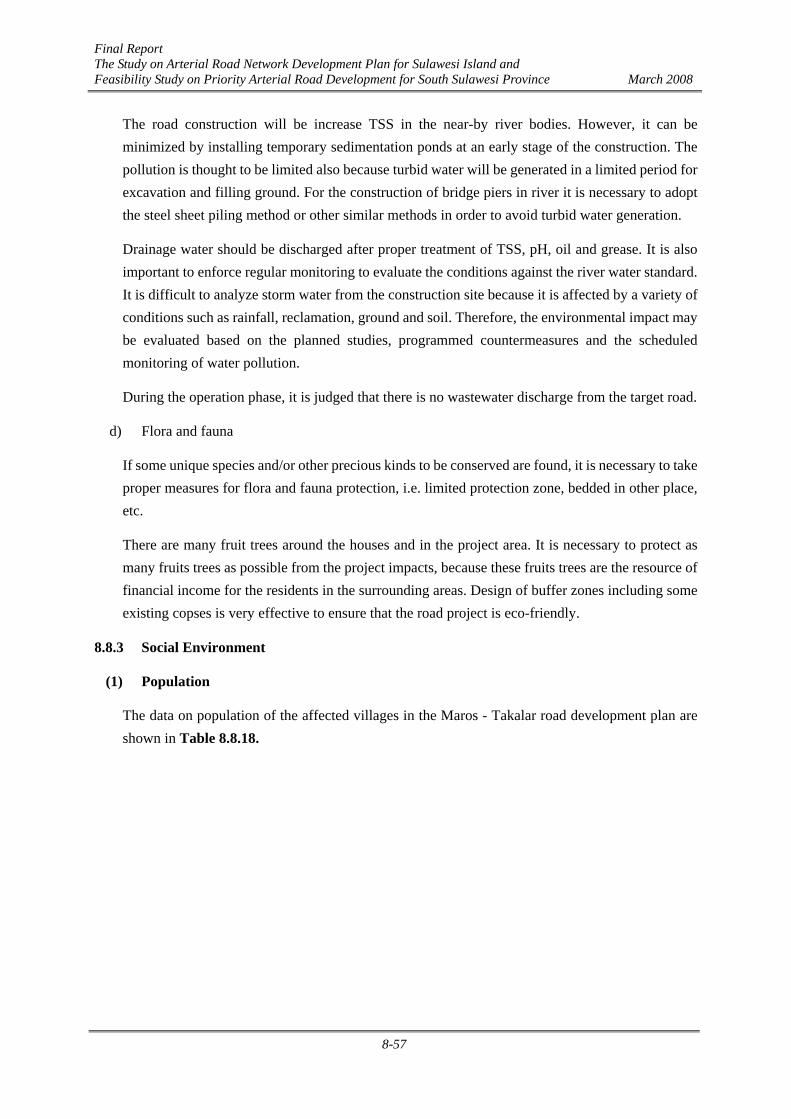
Final Report The Study on Arterial Road Network Development Plan for Sulawesi Island and Feasibility Study on Priority Arterial Road Development for South Sulawesi Province March 2008
8-57
The road construction will be increase TSS in the near-by river bodies. However, it can be minimized by installing temporary sedimentation ponds at an early stage of the construction. The pollution is thought to be limited also because turbid water will be generated in a limited period for excavation and filling ground. For the construction of bridge piers in river it is necessary to adopt the steel sheet piling method or other similar methods in order to avoid turbid water generation.
Drainage water should be discharged after proper treatment of TSS, pH, oil and grease. It is also important to enforce regular monitoring to evaluate the conditions against the river water standard. It is difficult to analyze storm water from the construction site because it is affected by a variety of conditions such as rainfall, reclamation, ground and soil. Therefore, the environmental impact may be evaluated based on the planned studies, programmed countermeasures and the scheduled monitoring of water pollution.
During the operation phase, it is judged that there is no wastewater discharge from the target road.
d) Flora and fauna
If some unique species and/or other precious kinds to be conserved are found, it is necessary to take proper measures for flora and fauna protection, i.e. limited protection zone, bedded in other place, etc.
There are many fruit trees around the houses and in the project area. It is necessary to protect as many fruits trees as possible from the project impacts, because these fruits trees are the resource of financial income for the residents in the surrounding areas. Design of buffer zones including some existing copses is very effective to ensure that the road project is eco-friendly.
8.8.3 Social Environment
(1) Population
The data on population of the affected villages in the Maros - Takalar road development plan are shown in Table 8.8.18.

Final Report The Study on Arterial Road Network Development Plan for Sulawesi Island and Feasibility Study on Priority Arterial Road Development for South Sulawesi Province March 2008
8-58
Table 8.8.18 Population of Affected Villages in the Maros - Takalar Road Development Plan Population
No Location Male Female Total
Maros District A. Turikale 1. Aliri Tengae 2. Pettuadae 3. Adatongeng 4. Taroada
3,357 2,262 3,081 3,116
2,334 2,442 3,146 3,251
5,691 4,704 6,227 6,367
B. Mandai 1. Hasanuddin
3,518
3,460
6,978
I.
C. Marusu 1. Marumpa
2,926
3,303
6,229
Makassar City A. Biringkanaya 1. Sudiang 2. Sudiang Raya 3. Bulurokeng 4. Paccerakang
12,519 13,241 2,868 14,739
13,028 13,543 3,103
15,030
25,547 26,784 5,971
29,769
B. Tamalanrea*) 1. Tamalanrea Indah 2. Tamalanrea Jaya 3. Tamalanrea 4. Kapasa
6,648 4,977 15,092 5,317
6,480 5,794
14,083 5,631
13,128 10,771 29,175 10,948
C. Manggala 1. Borong 2. Batua
7,673 9,026
8,163 9,161
15,836 18,187
D. Panakkukang 1. Tello Baru
4,950
5,414
10,364
E. Rappocini 1. Kassi-Kassi 2. Mappala 3. Karunrung 4. Gunung Sari
7,073 4,964 4,564 15,662
7,543 5,359 5,030
16,170
14,616 10,323 9,594
31,832
II.
F. Tamalate 1. Mangasa
10,911
11,453
22,364

Final Report The Study on Arterial Road Network Development Plan for Sulawesi Island and Feasibility Study on Priority Arterial Road Development for South Sulawesi Province March 2008
8-59
Gowa District A. Somba Opu
1. Pandang-pandang
2,721
3,004
5,725
B. Barombong 1. Tinggimae 2. Kanjilo
2,108 3,019
2,180 3,041
4,288 6,060
C. Pallangga 1. Bontoala 2. Jenetallasa 3. Taeng
5,355 5,394 2,452
5,473 5,609 2,554
10,828 11,003 5,006
D. Bajeng 1. Bontosunggu 2. Mataallo 3. Limbung 4. Kalebajeng 5. Tangke Bajeng
2,676 1,899 2,058 1,723 1,877
2,702 1,964 2,209 1,800 1,992
5,378 3,863 4,267 3,523 3,869
III.
E. Bontonompo 1. Bontonompo 2. Kalaserena 3. Tamallayang
1,749 1,279 2,298
1,880 1,303 2,448
3,629 2,582 4,740
Takalar District A. Polombangkeng Utara
1. Palleko 2. Manongkoki 3. Panranuangku 4. Malewang
1,364 1,687 1,704 1,518
1,558 1,858 1,850 1,670
2,922 3,545 3,554 3,188
IV.
B. Pattalassang 1. Bajeng 2. Kalabbirang 3. Sabintang 4. Sombalabella 5. Pattalassang
2,486 1,847 789
2,543 2,612
2,689 1,929 869
2,824 2,832
5,175 3,776 1,658 5,367 5,444
Source: Statistic Office of District/City *) Sub-District Office of Tamalanrea
The above table shows that administratively Makassar City, composed of six sub-districts and 16 villages with most populated areas, has the longest road section in the Maros-Takara Road Development Plan. On the other hand, the Takalar District with only two sub-districts and nine wards/villages has the shortest road section in the plan.
(2) Land Use by Section
The land use along the Project road is as follows:
Section A: Semi urban to urban areas from Maros to Jl Ir.Sutami. Urban area from Jl Ir.Sutami to Middle Ring along Jl.Perintis Kemerdekaan. There are shops, residential houses, industrial estates, government offices, and local markets along the project road.
Section B: Urban – semi urban areas. The start point of this section is located in the swamp area of the Tallo River basin. Approximately a half of the section is in the

Final Report The Study on Arterial Road Network Development Plan for Sulawesi Island and Feasibility Study on Priority Arterial Road Development for South Sulawesi Province March 2008
8-60
residential area and 20% in paddy fields.
Section C: Urban area around Jl.Sultan Alauddin and rural area after crossing the Jeneberang River. The road alignment passes mostly through paddy fields by-passing the villages.
Section D: Semi urban and rural areas along the existing national road from Sungguminasa to Takalar. The road passes through Limbung town located approximately 10 km south of Sungguminasa.
(3) Required Land Acquisition and Resettlement
Table 8.8.19 is an estimation and classification of the required land acquisition and resettlement based on site inventory. In general, 63% of the required land acquisition area is agricultural area. Almost 89% of section C and 71% of section B are agricultural area. In the other hand, 82% of section A and 48% of section D are residential area.
Table 8.8.19 Classification of Land Acquisition Unit (m2)
Road section Residential Bushes Agricultural Total
A1 79,000 15,000 2,000 96,000
B 84,000 0 210,000 294,000
C 14,000 26,000 320,000 360,000
D 210,000 10,000 220,000 440,000
Total 387,000 51,000 752,000 1,190,000
(4) Project affected buildings
Project affected buildings in total is about 2700 units, among them about 1700 units is in the Maros district along the section A of the Maros-Takalar road. The largest number is shops, most of (1080 units), along the section A of the road. On the other hand, most of the affected houses are in Gowa district, along section C and D of the road. Several houses and shops also affected by the road plan development project.
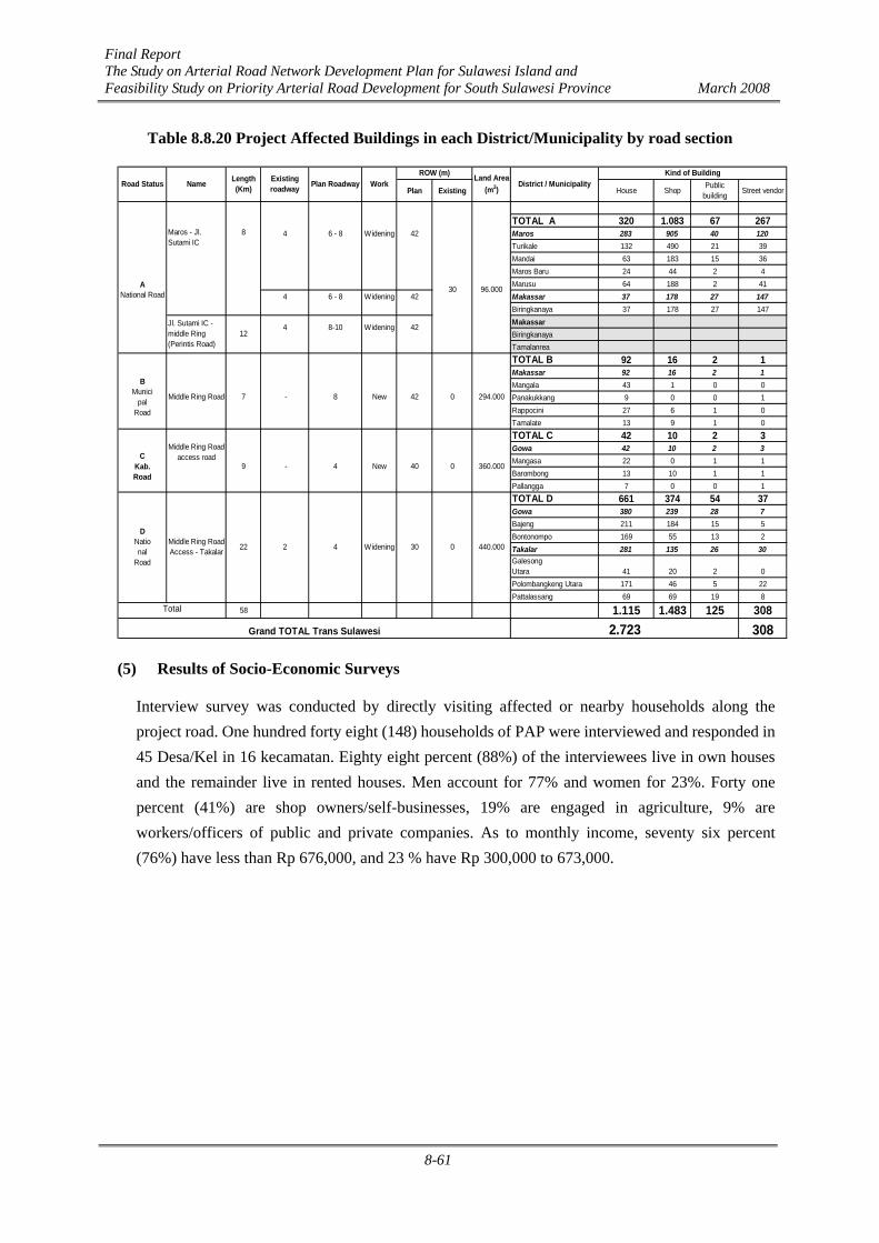
Final Report The Study on Arterial Road Network Development Plan for Sulawesi Island and Feasibility Study on Priority Arterial Road Development for South Sulawesi Province March 2008
8-61
Table 8.8.20 Project Affected Buildings in each District/Municipality by road section
Plan Existing House Shop Publicbuilding Street vendor
TOTAL A 320 1.083 67 2674 6 - 8 Widening 42 Maros 283 905 40 120
Turikale 132 490 21 39Mandai 63 183 15 36Maros Baru 24 44 2 4Marusu 64 188 2 41
4 6 - 8 Widening 42 Makassar 37 178 27 147Biringkanaya 37 178 27 147MakassarBiringkanayaTamalanreaTOTAL B 92 16 2 1Makassar 92 16 2 1Mangala 43 1 0 0Panakukkang 9 0 0 1Rappocini 27 6 1 0Tamalate 13 9 1 0TOTAL C 42 10 2 3Gowa 42 10 2 3Mangasa 22 0 1 1Barombong 13 10 1 1Pallangga 7 0 0 1TOTAL D 661 374 54 37Gowa 380 239 28 7Bajeng 211 184 15 5Bontonompo 169 55 13 2Takalar 281 135 26 30GalesongUtara 41 20 2 0Polombangkeng Utara 171 46 5 22Pattalassang 69 69 19 8
58 1.115 1.483 125 3083082.723
Road Status Name Length(Km)
Existingroadway Plan Roadway Work
ROW (m) Land Area(m2)
District / MunicipalityKind of Building
ANational Road
Maros - Jl.Sutami IC
8
30 96.000
Jl. Sutami IC -middle Ring(Perintis Road)
124 8-10 Widening 42
BMunici
palRoad
Middle Ring Road 7 -
0 360.000
8 New 42 0
22 2
294.000
CKab.Road
Middle Ring Roadaccess road
9 - 4 New 40
440.000
Total
Grand TOTAL Trans Sulawesi
4 Widening 30 0
DNational
Road
Middle Ring RoadAccess - Takalar
(5) Results of Socio-Economic Surveys
Interview survey was conducted by directly visiting affected or nearby households along the project road. One hundred forty eight (148) households of PAP were interviewed and responded in 45 Desa/Kel in 16 kecamatan. Eighty eight percent (88%) of the interviewees live in own houses and the remainder live in rented houses. Men account for 77% and women for 23%. Forty one percent (41%) are shop owners/self-businesses, 19% are engaged in agriculture, 9% are workers/officers of public and private companies. As to monthly income, seventy six percent (76%) have less than Rp 676,000, and 23 % have Rp 300,000 to 673,000.
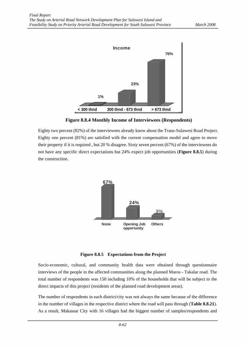
Final Report The Study on Arterial Road Network Development Plan for Sulawesi Island and Feasibility Study on Priority Arterial Road Development for South Sulawesi Province March 2008
8-62
Figure 8.8.4 Monthly Income of Interviewees (Respondents)
Eighty two percent (82%) of the interviewees already know about the Trans-Sulawesi Road Project. Eighty one percent (81%) are satisfied with the current compensation model and agree to move their property if it is required , but 20 % disagree. Sixty seven percent (67%) of the interviewees do not have any specific direct expectations but 24% expect job opportunities (Figure 8.8.5) during the construction.
None Opening Jobopportunity
Others
Expectation from Project
67%
24%
9%
Figure 8.8.5 Expectations from the Project
Socio-economic, cultural, and community health data were obtained through questionnaire interviews of the people in the affected communities along the planned Maros - Takalar road. The total number of respondents was 150 including 10% of the households that will be subject to the direct impacts of this project (residents of the planned road development areas).
The number of respondents in each district/city was not always the same because of the difference in the number of villages in the respective district where the road will pass through (Table 8.8.21). As a result, Makassar City with 16 villages had the biggest number of samples/respondents and
Income
300 rb – 673 rb >673 rb
1%
23%
76%
300 rb< 300 thnd 300 thnd - 673 thnd > 673 thnd

Final Report The Study on Arterial Road Network Development Plan for Sulawesi Island and Feasibility Study on Priority Arterial Road Development for South Sulawesi Province March 2008
8-63
Maros District with only 6 villages had the smallest number of respondents
Table 8.8.21 Number of Respondent in Each District/City No District/City Number of Respondent
1 Maros 21
2 Makassar 49
3 Gowa 42
4 Takalar 38
Total 150
Source: Analyzed Primary Data, 2007
Table 8.8.22 Number of Respondents by Age Group Age Group(%)
No District/City ≤ 19 20 - 39 40 - 59 ≥ 60
Total (%)
1 Maros 4 48 24 24 100
2 Makassar 0 45 51 4 100
3 Gowa 0 17 69 14 100
4 Takalar 0 18 69 13 100
Source: Analyzed Primary Data, 2007
Table 8.8.22 shows that the dominant age group of respondents (householders) is 40 - 59 years in most districts along the planned Maros - Takalar road, but it is only 20 - 39 years in Maros District.
Table 8.8.23 Educational Background of Respondents Educational Background (%)
No DistrictCity Drop-
out Elementary
Junior
High
Senior
High University
Total
1 Maros 0 23 10 57 10 100
2 Makassar 4 12 6 39 39 100
3 Gowa 7 33 14 26 20 100
4 Takalar 26 21 24 29 0 100
Source: Analyzed Primary Data, 2007
Table 8.8.23 shows that the educational background of the respondents in the study area is quite varied, with the dominant one being the senior high school level. People with drop-out or never attending school background are still found in three regencies/cities, and they are dominant in Takalar District. Among the regencies/cities, Makassar City has the biggest number of university graduates.

Final Report The Study on Arterial Road Network Development Plan for Sulawesi Island and Feasibility Study on Priority Arterial Road Development for South Sulawesi Province March 2008
8-64
Table 8.8.24 Respondents’ Residential Status Residency Status (%)
No District/City Own Contract Stay
Total
1 Maros 100 0 0 100
2 Makassar 69 29 2 100
3 Gowa 98 0 2 100
4 Takalar 95 5 0 100
Source: Analyzed Primary Data, 2007
Table 8.8.24 shows that most residents in the planned Maros - Takalar road development areas own land and only few of them stay with their relatives. Table 8.8.25 shows that the function of respondents’ houses is dominantly for living and doing business. There are relatively many living-business places where the planned Maros - Takalar road will pass through, but places for business solely are rarely found in the study area.
Table 8.8.25 Function of Respondents’ Houses House Function (%)
No District/City Place of
Living
Place of Living
and Business Other
Total
1 Maros 10 90 0 100
2 Makassar 18 74 8 100
3 Gowa 81 19 0 100
4 Takalar 76 24 0 100
Source: Interview Survey
Table 8.8.26 Livelihood Type of Respondents Livelihood
No District/City 1 2 3 4 5 6 7 8
Total
1 Maros 62 0 14 5 5 0 0 14 100
2 Makassar 53 10 29 2 6 0 0 0 100
3 Gowa 18 17 9 5 5 7 29 10 100
4 Takalar 32 0 7 3 5 0 50 3 100
Source: Analyzed Primary Data, 2007 Remarks: 1. Merchant 2. Officer/Police/Army 3. Private Officer 4. Retiree 5. Craftsman 6. Labor 7. Peasant 8. Other
Table 8.8.26 shows the various types of respondents’ livelihood. Mainly, the dominant livelihood among the people in the regencies/cities is merchant, officer/police/army, private officer, and peasant. In Maros District and Makassar City, merchant is the most dominant livelihood of the respondents. Meanwhile in Gowa District and Takalar District, peasant is the most dominant livelihood among the respondents.

Final Report The Study on Arterial Road Network Development Plan for Sulawesi Island and Feasibility Study on Priority Arterial Road Development for South Sulawesi Province March 2008
8-65
Table 8.8.27 Respondents’ Income Level Income Level (%)
No District/City < Rp.
300.000,-
Rp. 300.000,- – Rp.
673.000,-
> Rp.
673.000,-
Total
1 Maros 0 5 95 100
2 Makassar 0 6 94 100
3 Gowa 5 12 83 100
4 Takalar 0 68 32 100
Source: Analyzed Primary Data, 2007
Table 8.8.27 shows that the income level of respondents is very varied and dominantly is above the Provincial Minimum Wage of Rp. 673,200. The respondents’ income varies from Rp. 250,000 to Rp. 50,000,000 and the trading activity represents the biggest income source of the respondents. In Gowa District, there are few respondents with an income of less than Rp. 300,000 and in Takalar District, the dominant income averages Rp. 300,000 to Rp. 673,200. But, the average income rate of the respondents as a whole is far above the Provincial Minimum Wage, reaching as much as Rp. 2,750,000 per month.
Table 8.8.28 Respondents’ perception on the project plan Perception/opinion (%) No District/City
Agree Disagree Total
1 Maros 73.5 26.5 100 2 Makassar 83.3 17.7 100 3 Gowa 97.4 2.6 100 4 Takalar 66.7 33.3 100
Average 81.3 18.7 100
Table 8.8.28 shows that about 81% of respondents agree on the project plan. This opinion is based on the condition that the land acquisition will be executed accordance to the regulations. Most of disagree persons are the person who does not want to relocate to other places. And about 24% of respondents express their expectation to have work opportunities during the project implementation.
(6) Culture/Custom
Regarding the culture and customs of the affected communities, the community activities inherently with mutual assistance such as environmental cleaning, religious building construction, house repair, and area security show that there have been an established norm system through the community participation in doing the cooperation among insiders and outsiders in the community.
The mutual assistance activities are very often performed by community in study area are communal work on cleaning the surrounding and keeping the area security such as water channel cleaning, road, and area security security (siskamling). This activity includes the religious events activities which are conducted in communal work spirit such as celebrating the religious holidays
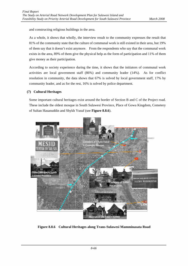
Final Report The Study on Arterial Road Network Development Plan for Sulawesi Island and Feasibility Study on Priority Arterial Road Development for South Sulawesi Province March 2008
8-66
and constructing religious buildings in the area.
As a whole, it shows that wholly, the interview result to the community expresses the result that 81% of the community state that the culture of communal work is still existed in their area, but 19% of them say that it doesn’t exist anymore. From the respondents who say that the communal work exists in the area, 89% of them give the physical help as the form of participation and 11% of them give money as their participation.
According to society experience during the time, it shows that the initiators of communal work activities are local government staff (86%) and community leader (14%). As for conflict resolution in community, the data shows that 67% is solved by local government staff, 17% by community leader, and as for the rest, 16% is solved by police department.
(7) Cultural Heritages
Some important cultural heritages exist around the border of Section B and C of the Project road. These include the oldest mosque in South Sulawesi Province, Place of Gowa Kingdom, Cemetery of Sultan Hasanuddin and Shykh Yusuf (see Figure 8.8.6).
Oldest Mosque in SouthSulawesi Province
Museum of Old Palace (Gowa)
Cemetery of SultanHasanuddin
& Katangka MosqueCemetery of Shykh Yusuf
Trans-Sulawesi Section C
Trans-Sulawesi Section B
Figure 8.8.6 Cultural Heritages along Trans-Sulawesi Mamminasata Road

Final Report The Study on Arterial Road Network Development Plan for Sulawesi Island and Feasibility Study on Priority Arterial Road Development for South Sulawesi Province March 2008
8-67
(8) Traffic Jam
Figure 8.8.7 shows a comparison of traffic congestion conditions in 2006 and 2023 without any new road development. The current traffic congestion is mostly on Jl.Perintis Kemerdekaan, Jl.Ir.Sutami, Jl.Urip Sumoharjo and some other urban roads in the Makassar old town centre. However, most of the road links would face traffic jam in 2023. Especially, it is serious on Jl.Perintis Kemerdekaan, Jl.Ir.Sutami, Jl.Urip Sumoharjo, Jl.Sultan Alauddin, Jl.Gowa Raya, Jl.Abdullah Daeng Sirua and national roads from Maros to Jl.Ir.Sutami IC and Sungguminasa to Takalar. The Trans-Sulawesi Mamminasata Road Project will substantially contribute to reducing these traffic constraints.
Traffic Congestion in 2006 Traffic Congestion in 2023
93
297264
233301340
352
380
356
248
185
157
127 129
129
99
77 108
44
18
214
6868
37
37
28
1321
2
13
284
176 483
259287
287
32
24
11
11
305230
230
170
41 9067 47
217
151 43
80305505618
46
163 29
2
98
50 31
7626
310
46
86
500
76
74
52
6
8
17
191 67
88
14
27
225
31
31
29
29
64
64
22
24
3
26
23
32
17
15
11
114
17
42
59
51
191
18674 16
1153
311 160200
87
320366
347
495
449
723
159
38
159106
203
93
1697437
9
178
143
165
492
153
204
162
98
55
178
8
1046 6
84
230
51
59
51
75
70
563
24
181
206288
36
36
87
193217 723
563
449
347
153
Maros
Takalar
Sungguminasa
Makassar
- - - - - - -Trans-SualwesiMamminasata Road
Figure 8.8.7 Traffic Congestion (Jam) Without-Project Case
8.8.4 Summary of Impacts under AMDAL Impact Matrix
The following table summarizes the impacts under the AMDAL impact matrix, showing the major impacts during the pre-construction, construction and post-construction stages of the Trans-Sulawesi Mamminasata Section.

Final Report The Study on Arterial Road Network Development Plan for Sulawesi Island and Feasibility Study on Priority Arterial Road Development for South Sulawesi Province March 2008
8-68
Table 8.8.29 Matrix of Hypothetical Significant Impact of Maros - Takalar Road Development in South Sulawesi
Pre-constructi
on Stage Construction Stage
Post-constr
uction Stage
No
Activity Stage
Environmental Components
Re-
mea
sure
men
t
Lan
d A
cqui
stio
n
Mat
eria
ls M
obili
zatio
n
Lab
or A
vaila
bilit
y
Loc
atio
n
Cle
anin
g R
oad/
Bri
dge
Con
stru
ctio
n
Net
wor
k/ F
acili
ty
Ope
ratio
n
Mai
nten
ance
I PHYSICAL-CHEMICAL
COMPONENTS
1. Air Quality - P - TP
2. Hydrology - P
3. Water Quality -
TP
4. Road Facility - P
5. Traffic Flows - P + P
6. Space, Road, and Land - TP
II BIOLOGICAL COMPONENTS
1. Flora - P + P
2. Fauna - P + P
III SOCIAL CULTURE-PUBLIC
HEALTH COMPONENTS
1. Social Perception - TP - P - P
2. Job Opportunity + P
3. Social Interaction - TP
4. Historic Heritages - TP
5. Public Health - P -TP
6. Green Area / Aesthetics +
P
Category : P = Important - = Negative Impact
TP = Not Important + = Positive Impact
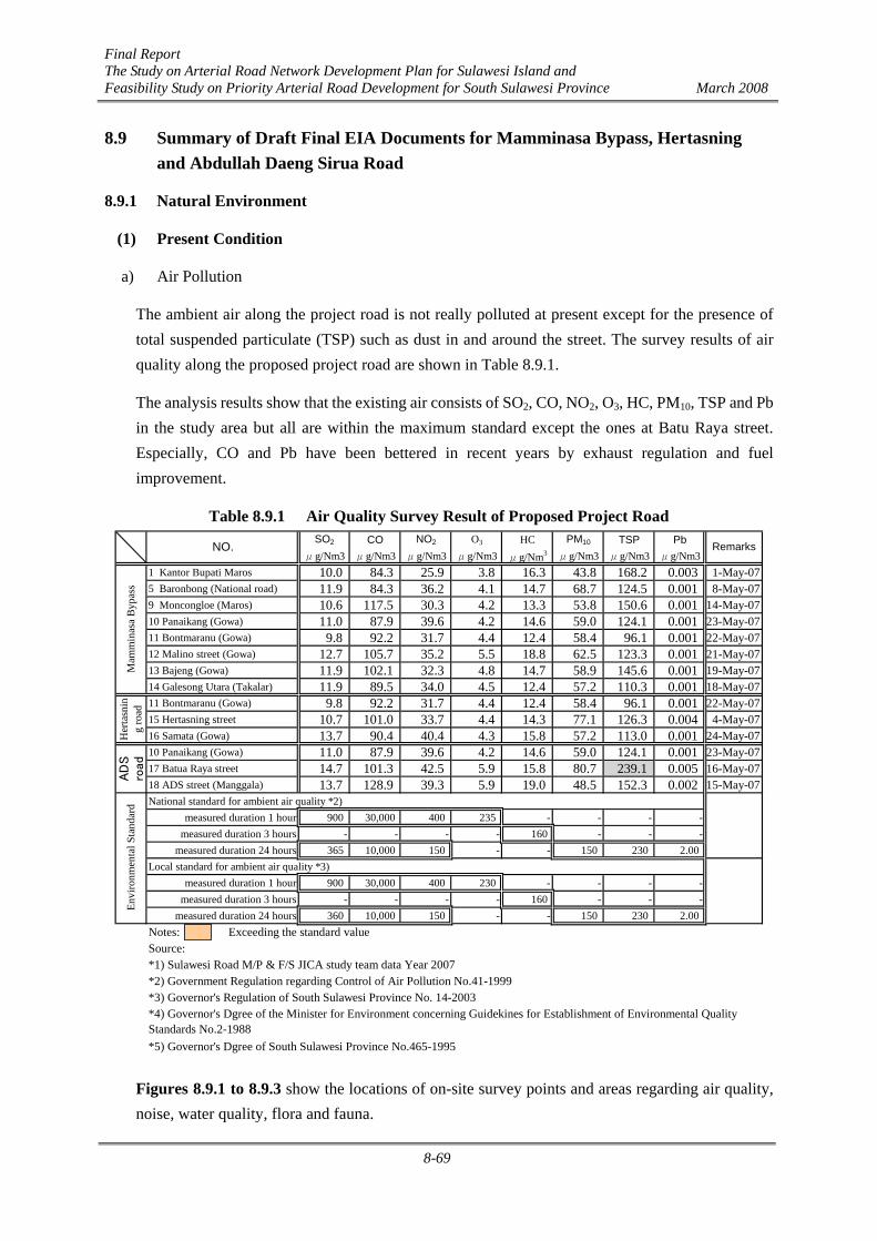
Final Report The Study on Arterial Road Network Development Plan for Sulawesi Island and Feasibility Study on Priority Arterial Road Development for South Sulawesi Province March 2008
8-69
8.9 Summary of Draft Final EIA Documents for Mamminasa Bypass, Hertasning and Abdullah Daeng Sirua Road
8.9.1 Natural Environment
(1) Present Condition
a) Air Pollution
The ambient air along the project road is not really polluted at present except for the presence of total suspended particulate (TSP) such as dust in and around the street. The survey results of air quality along the proposed project road are shown in Table 8.9.1.
The analysis results show that the existing air consists of SO2, CO, NO2, O3, HC, PM10, TSP and Pb in the study area but all are within the maximum standard except the ones at Batu Raya street. Especially, CO and Pb have been bettered in recent years by exhaust regulation and fuel improvement.
Table 8.9.1 Air Quality Survey Result of Proposed Project Road SO2 CO NO2 O3 HC PM10 TSP Pb
μg/Nm3 μg/Nm3 μg/Nm3 μg/Nm3 μg/Nm3 μg/Nm3 μg/Nm3 μg/Nm31 Kantor Bupati Maros 10.0 84.3 25.9 3.8 16.3 43.8 168.2 0.003 1-May-075 Baronbong (National road) 11.9 84.3 36.2 4.1 14.7 68.7 124.5 0.001 8-May-079 Moncongloe (Maros) 10.6 117.5 30.3 4.2 13.3 53.8 150.6 0.001 14-May-0710 Panaikang (Gowa) 11.0 87.9 39.6 4.2 14.6 59.0 124.1 0.001 23-May-0711 Bontmaranu (Gowa) 9.8 92.2 31.7 4.4 12.4 58.4 96.1 0.001 22-May-0712 Malino street (Gowa) 12.7 105.7 35.2 5.5 18.8 62.5 123.3 0.001 21-May-0713 Bajeng (Gowa) 11.9 102.1 32.3 4.8 14.7 58.9 145.6 0.001 19-May-0714 Galesong Utara (Takalar) 11.9 89.5 34.0 4.5 12.4 57.2 110.3 0.001 18-May-0711 Bontmaranu (Gowa) 9.8 92.2 31.7 4.4 12.4 58.4 96.1 0.001 22-May-0715 Hertasning street 10.7 101.0 33.7 4.4 14.3 77.1 126.3 0.004 4-May-0716 Samata (Gowa) 13.7 90.4 40.4 4.3 15.8 57.2 113.0 0.001 24-May-0710 Panaikang (Gowa) 11.0 87.9 39.6 4.2 14.6 59.0 124.1 0.001 23-May-0717 Batua Raya street 14.7 101.3 42.5 5.9 15.8 80.7 239.1 0.005 16-May-0718 ADS street (Manggala) 13.7 128.9 39.3 5.9 19.0 48.5 152.3 0.002 15-May-07National standard for ambient air quality *2)
measured duration 1 hour 900 30,000 400 235 - - - -measured duration 3 hours - - - - 160 - - -
measured duration 24 hours 365 10,000 150 - - 150 230 2.00Local standard for ambient air quality *3)
measured duration 1 hour 900 30,000 400 230 - - - -measured duration 3 hours - - - - 160 - - -
measured duration 24 hours 360 10,000 150 - - 150 230 2.00Notes: Exceeding the standard valueSource:*1) Sulawesi Road M/P & F/S JICA study team data Year 2007*2) Government Regulation regarding Control of Air Pollution No.41-1999*3) Governor's Regulation of South Sulawesi Province No. 14-2003
*5) Governor's Dgree of South Sulawesi Province No.465-1995
*4) Governor's Dgree of the Minister for Environment concerning Guidekines for Establishment of Environmental QualityStandards No.2-1988
Mam
min
asa
Byp
ass
Her
tasn
ing
road
Envi
ronm
enta
l Sta
ndar
dA
DS
road
RemarksNO.
Figures 8.9.1 to 8.9.3 show the locations of on-site survey points and areas regarding air quality, noise, water quality, flora and fauna.
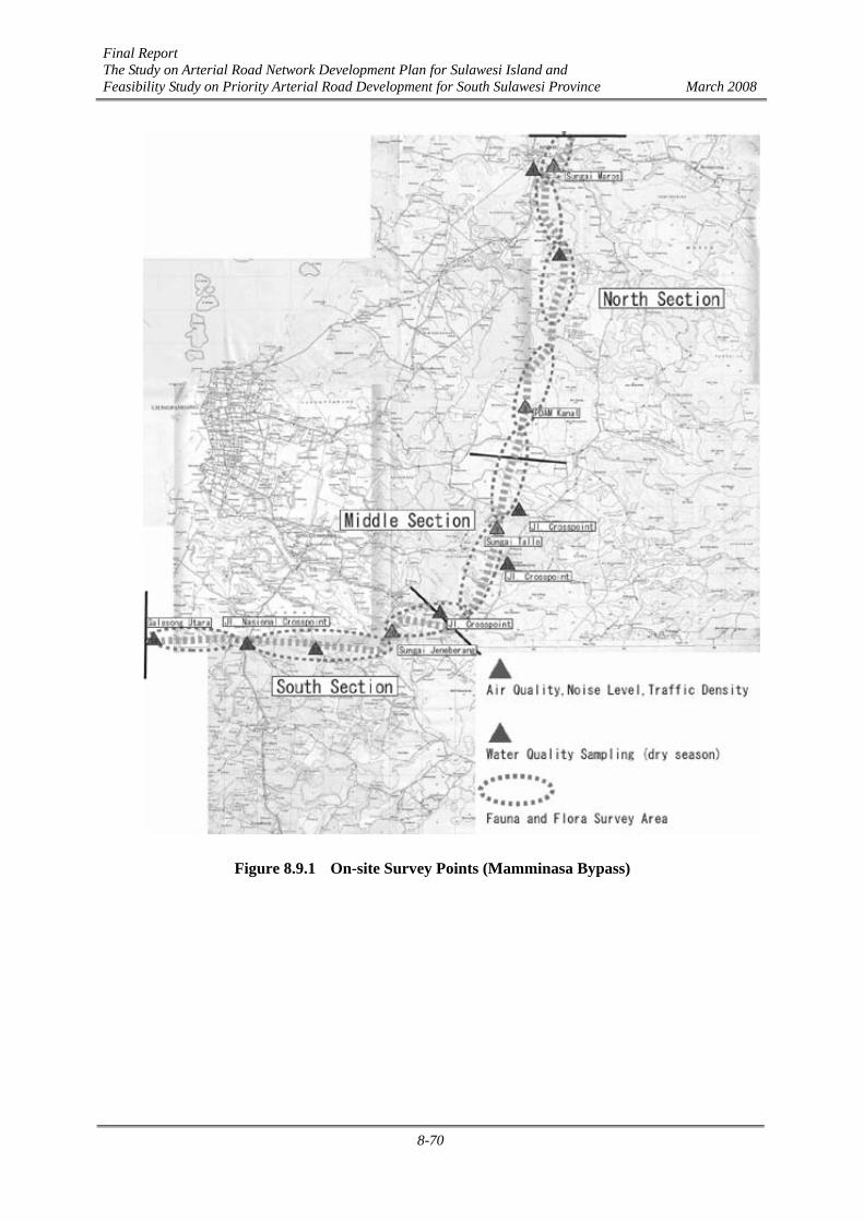
Final Report The Study on Arterial Road Network Development Plan for Sulawesi Island and Feasibility Study on Priority Arterial Road Development for South Sulawesi Province March 2008
8-70
Figure 8.9.1 On-site Survey Points (Mamminasa Bypass)

Final Report The Study on Arterial Road Network Development Plan for Sulawesi Island and Feasibility Study on Priority Arterial Road Development for South Sulawesi Province March 2008
8-71
Figure 8.9.2 On-site Survey Points (Hertasning Road)
Figure 8.9.3 On-site Survey Points (Abdullah Daeng Sirua Road)

Final Report The Study on Arterial Road Network Development Plan for Sulawesi Island and Feasibility Study on Priority Arterial Road Development for South Sulawesi Province March 2008
8-72
b) Noise Level
A summary of noise measurements along the Project road is shown in Table 8.9.2. All noise levels in the daytime along the national road and in the city area exceeded the Environmental Standard for commercial and service areas. The noise levels in the night time are mostly less than the admissible limit. The maximum noise levels are almost 80 dB(A) at Barombong point, Hertasning street and Batua Raya street.
Table 8.9.2 Noise Level Survey Results of Proposed Project Road
daytime night
1 Kantor Bupati Maros 72.8 66.2 69.5 77.2 1-May-075 Baronbong (National road) 70.9 62.3 66.6 79.2 8-May-079 Moncongloe (Maros) 66.2 59.1 62.6 70.2 14-May-0710 Panaikang (Gowa) 60.0 52.8 56.4 67.2 23-May-0711 Bontmaranu (Gowa) 60.9 51.9 56.4 67.3 22-May-0712 Malino street (Gowa) 69.8 56.7 63.3 71.9 21-May-0713 Bajeng (Gowa) 58.6 50.9 54.7 64.0 19-May-0714 Galesong Utara (Takalar) 58.8 49.5 54.1 67.8 18-May-0711 Bontmaranu (Gowa) 60.9 51.9 56.4 67.3 22-May-0715 Hertasning street 74.4 59.9 67.2 79.0 4-May-0716 Samata (Gowa) 64.0 55.9 60.0 66.6 24-May-0710 Panaikang (Gowa) 60.0 52.8 56.4 67.2 23-May-0717 Batua Raya street 72.2 64.7 68.3 78.9 16-May-0718 ADS street (Manggala) 65.9 51.2 58.6 69.5 15-May-07
Area classification National Provincial Commercial and Service 70.0 70.0 Industry 70.0 70.0 Office Buildings and Commercial 65.0 65.0 Recreation 70.0 65.0 Government and Public Facilities 60.0 60.0 Housing and Settlement 55.0 55.0 Green Open Space 50.0 50.0
Notes: Exceeding the standard value (Maximum Environmental Standard: 70dB(A))Source : Sulawesi Road M/P & F/S JICA study team data Year 2007
Envi
ronm
enta
l Sta
ndar
dA
DS
road
L50
Mam
min
asa
Byp
ass
Her
tasn
ing
road
Average Remarks(data)NO. Max L50
c) Water Pollution
The results of quality tests of water sampled along the Project road are summarized in Table 8.9.3. Several values exceed the River Water Quality Standards but are still not so big.
The TSS density is relatively high as a characteristic of Indonesia, however the TSS value recorded at all survey points is below the Environmental Standard. BOD5 values are also relatively low for the reason that the sampling points are not located in the high population density area.
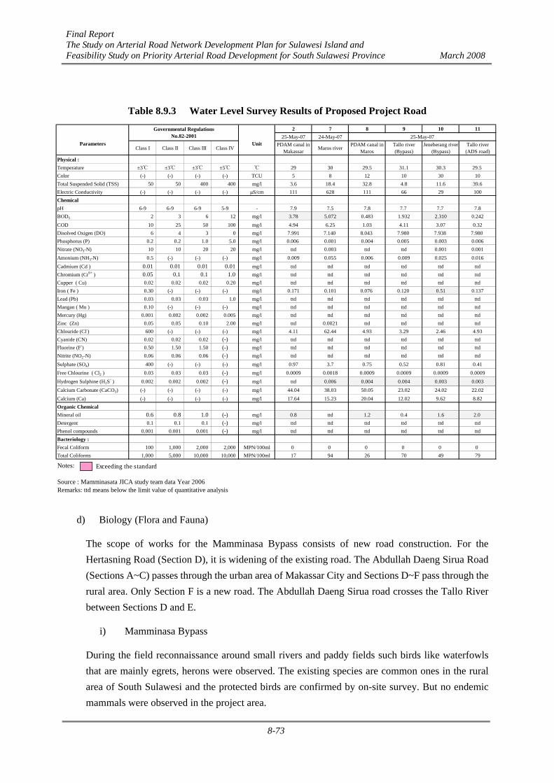
Final Report The Study on Arterial Road Network Development Plan for Sulawesi Island and Feasibility Study on Priority Arterial Road Development for South Sulawesi Province March 2008
8-73
Table 8.9.3 Water Level Survey Results of Proposed Project Road 2 7 8 9 10 11
25-May-07 24-May-07 25-May-07
Class I Class II Class III Class IVPDAM canal in
Makassar Maros riverPDAM canal in
MarosTallo river(Bypass)
Jeneberang river(Bypass)
Tallo river(ADS road)
Physical :Temperature ±3℃ ±3℃ ±3℃ ±5℃ ℃ 29 30 29.5 31.1 30.3 29.5Color (-) (-) (-) (-) TCU 5 8 12 10 30 10Total Suspended Solid (TSS) 50 50 400 400 mg/l 3.6 18.4 32.8 4.8 11.6 39.6Electric Conductivity (-) (-) (-) (-) μS/cm 111 628 111 66 29 100ChemicalpH 6-9 6-9 6-9 5-9 - 7.9 7.5 7.8 7.7 7.7 7.8BOD5 2 3 6 12 mg/l 3.78 5.072 0.483 1.932 2.310 0.242COD 10 25 50 100 mg/l 4.94 6.25 1.03 4.11 3.07 0.32Disolved Oxigen (DO) 6 4 3 0 mg/l 7.991 7.140 8.043 7.980 7.938 7.980Phosphorus (P) 0.2 0.2 1.0 5.0 mg/l 0.006 0.001 0.004 0.005 0.003 0.006Nitrate (NO3-N) 10 10 20 20 mg/l ttd 0.003 ttd ttd 0.001 0.001Amonium (NH3-N) 0.5 (-) (-) (-) mg/l 0.009 0.055 0.006 0.009 0.025 0.016Cadmium (Cd ) 0.01 0.01 0.01 0.01 mg/l ttd ttd ttd ttd ttd ttdChromium (Cr6+ ) 0.05 0.1 0.1 1.0 mg/l ttd ttd ttd ttd ttd ttdCupper ( Cu) 0.02 0.02 0.02 0.20 mg/l ttd ttd ttd ttd ttd ttdIron ( Fe ) 0.30 (-) (-) (-) mg/l 0.171 0.101 0.076 0.120 0.51 0.137Lead (Pb) 0.03 0.03 0.03 1.0 mg/l ttd ttd ttd ttd ttd ttdMangan ( Mn ) 0.10 (-) (-) (-) mg/l ttd ttd ttd ttd ttd ttdMercury (Hg) 0.001 0.002 0.002 0.005 mg/l ttd ttd ttd ttd ttd ttdZinc (Zn) 0.05 0.05 0.10 2.00 mg/l ttd 0.0021 ttd ttd ttd ttdChlouride (Cl-) 600 (-) (-) (-) mg/l 4.11 62.44 4.93 3.29 2.46 4.93Cyanide (CN) 0.02 0.02 0.02 (-) mg/l ttd ttd ttd ttd ttd ttdFluorine (F-) 0.50 1.50 1.50 (-) mg/l ttd ttd ttd ttd ttd ttdNitrite (NO2-N) 0.06 0.06 0.06 (-) mg/l ttd ttd ttd ttd ttd ttdSulphate (SO4) 400 (-) (-) (-) mg/l 0.97 3.7 0.75 0.52 0.81 0.41Free Chlourine ( Cl2 ) 0.03 0.03 0.03 (-) mg/l 0.0009 0.0018 0.0009 0.0009 0.0009 0.0009Hydrogen Sulphine (H2S
- ) 0.002 0.002 0.002 (-) mg/l ttd 0.006 0.004 0.004 0.003 0.003Calcium Carbonate (CaCO3) (-) (-) (-) (-) mg/l 44.04 38.03 50.05 23.02 24.02 22.02Calcium (Ca) (-) (-) (-) (-) mg/l 17.64 15.23 20.04 12.02 9.62 8.82Organic ChemicalMineral oil 0.6 0.8 1.0 (-) mg/l 0.8 ttd 1.2 0.4 1.6 2.0Detergent 0.1 0.1 0.1 (-) mg/l ttd ttd ttd ttd ttd ttdPhenol compounds 0.001 0.001 0.001 (-) mg/l ttd ttd ttd ttd ttd ttdBacteriology :Fecal Coliform 100 1,000 2,000 2,000 MPN/100ml 0 0 0 0 0 0Total Coliforms 1,000 5,000 10,000 10,000 MPN/100ml 17 94 26 70 49 79
Notes:
Source : Mamminasata JICA study team data Year 2006Remarks: ttd means below the limit value of quantitative analysis
Parameters Unit
Governmental RegulationsNo.82-2001
Exceeding the standard
d) Biology (Flora and Fauna)
The scope of works for the Mamminasa Bypass consists of new road construction. For the Hertasning Road (Section D), it is widening of the existing road. The Abdullah Daeng Sirua Road (Sections A~C) passes through the urban area of Makassar City and Sections D~F pass through the rural area. Only Section F is a new road. The Abdullah Daeng Sirua road crosses the Tallo River between Sections D and E.
i) Mamminasa Bypass
During the field reconnaissance around small rivers and paddy fields such birds like waterfowls that are mainly egrets, herons were observed. The existing species are common ones in the rural area of South Sulawesi and the protected birds are confirmed by on-site survey. But no endemic mammals were observed in the project area.

Final Report The Study on Arterial Road Network Development Plan for Sulawesi Island and Feasibility Study on Priority Arterial Road Development for South Sulawesi Province March 2008
8-74
Table 8.9.4 Survey Results of Fauna (Birds in Mamminasa Bypass South Section)
No. Local Name Species NameIndividualNumber
1 layang-layang Hirundo tahitica 122 kacamata Zosterops chloris 23 kuntul kerbau Egretta intermnedia 34 kepudang Lonchura molucca 15 kutilang Pygnonotus aurigaster 146 burung gereja Passer montanus 57 raja udang Halcyon chloris 28 bondol kepala pucat Lonchura pallida 29 bondol kepala hitam Lonchura molucca 710 bondol kepala putih Loncura palida 511 kepudang sungubelang Coracina bicolor 312 burung madu Nectarinia jugularis 1
1257
Total SpesiesTotal Individual Number
Table 8.9.5 Survey Results of Fauna (Birds in Mamminasa Bypass Middle Section)
No. Local Name Species NameIndividualNumber
1 layang-layang Hirundo tahitica 62 kacamata Zosterops chloris 23 kepudang Oriouls chinensis 14 burung gereja Passer montanus 125 bondol kepala hitam Lonchura molucca 2
523
Total SpesiesTotal Individual Number
Table 8.9.6 Survey Result of Fauna (Birds in Mamminasa Bypass North Section)
No. Local Name Species NameIndividualNumber
1 layang-layang Hirundo tahitica 342 kacamata Zosterops chloris 63 kuntul perak Egretta intermnedia 124 kuntul kerbau Bubulcus ibis 385 kutilang Pygnonotus aurigaster 146 burung gereja Passer montanus 57 raja udang Halcyon chloris 18 bondol kepala hitam Lonchura molucca 129 bangau abu2 Egretta sp. 110 kepudang sungu Coracina bicolor 111 merpati 4
11128
Total SpesiesTotal Individual Number
Vegetation consists mostly of planted species along the proposed road such as mango trees, coconuts, bananas, other fruit trees, and so on. It seems that the precious vegetation species listed or designated in the standards of Indonesia are not found around the project area. The project road passes almost through paddy fields.
ii) Hertasning Road
The proposed road for F/S is only Section D located in the rural area of Gowa. Some birds like
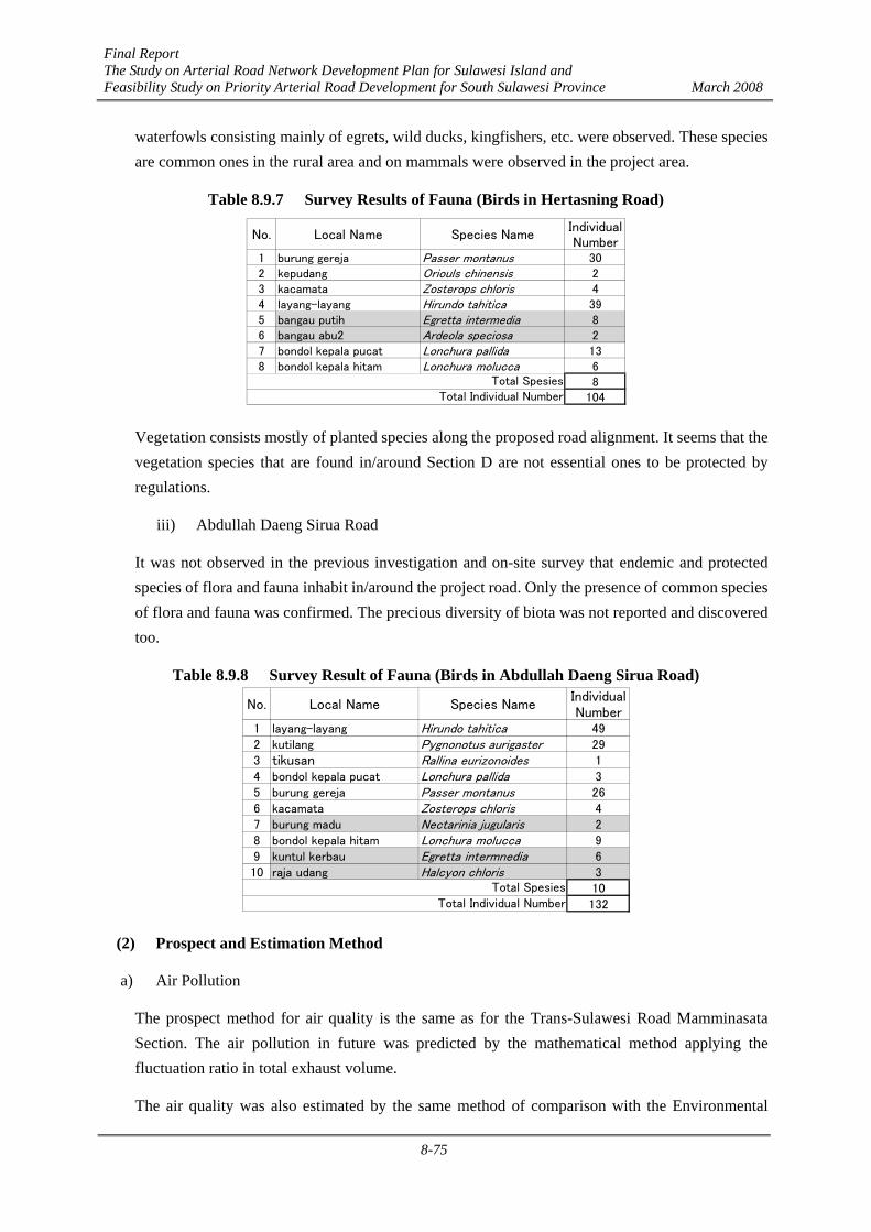
Final Report The Study on Arterial Road Network Development Plan for Sulawesi Island and Feasibility Study on Priority Arterial Road Development for South Sulawesi Province March 2008
8-75
waterfowls consisting mainly of egrets, wild ducks, kingfishers, etc. were observed. These species are common ones in the rural area and on mammals were observed in the project area.
Table 8.9.7 Survey Results of Fauna (Birds in Hertasning Road)
No. Local Name Species NameIndividualNumber
1 burung gereja Passer montanus 302 kepudang Oriouls chinensis 23 kacamata Zosterops chloris 44 layang-layang Hirundo tahitica 395 bangau putih Egretta intermedia 86 bangau abu2 Ardeola speciosa 27 bondol kepala pucat Lonchura pallida 138 bondol kepala hitam Lonchura molucca 6
8104
Total SpesiesTotal Individual Number
Vegetation consists mostly of planted species along the proposed road alignment. It seems that the vegetation species that are found in/around Section D are not essential ones to be protected by regulations.
iii) Abdullah Daeng Sirua Road
It was not observed in the previous investigation and on-site survey that endemic and protected species of flora and fauna inhabit in/around the project road. Only the presence of common species of flora and fauna was confirmed. The precious diversity of biota was not reported and discovered too.
Table 8.9.8 Survey Result of Fauna (Birds in Abdullah Daeng Sirua Road)
No. Local Name Species NameIndividualNumber
1 layang-layang Hirundo tahitica 492 kutilang Pygnonotus aurigaster 293 tikusan Rallina eurizonoides 14 bondol kepala pucat Lonchura pallida 35 burung gereja Passer montanus 266 kacamata Zosterops chloris 47 burung madu Nectarinia jugularis 28 bondol kepala hitam Lonchura molucca 99 kuntul kerbau Egretta intermnedia 610 raja udang Halcyon chloris 3
10132
Total SpesiesTotal Individual Number
(2) Prospect and Estimation Method
a) Air Pollution
The prospect method for air quality is the same as for the Trans-Sulawesi Road Mamminasata Section. The air pollution in future was predicted by the mathematical method applying the fluctuation ratio in total exhaust volume.
The air quality was also estimated by the same method of comparison with the Environmental

Final Report The Study on Arterial Road Network Development Plan for Sulawesi Island and Feasibility Study on Priority Arterial Road Development for South Sulawesi Province March 2008
8-76
Standard in principle.
b) Noise Level
The prospect method for noise level is the same as for the Trans-Sulawesi Road Mamminasata Section. The Mamminasa Bypass is classified as a national road, while the Hertasning and Abdullah Daeng Sirua Road are city and/or prefectural roads.
The coefficients used in calculation formula are the same as for the Trans-Sulawesi Road Mamminasata Section.
The noise level was also estimated by the same method as for the Trans-Sulawesi Road Mamminasata Section, by comparing with the Environmental Standard.
c) Water Pollution
The prospect method for water pollution is also the same as for the Trans-Sulawesi Road Mamminasata Section, applying the perfect mixed formula. The water pollution was estimated by the same method as for the Trans-Sulawesi Road Mamminasata Section, by comparing with the Environmental Standard.
d) Flora and fauna
The prospect method for flora and fauna is also the same as for the Trans-Sulawesi Road Mamminasata Section. But as these project roads pass through the rural area and some copses, it was assumed that the possibility of existence of habitations of endangered and protected species is relatively high. Especially, it is necessary to consider and observe the flora and fauna along the proposed route of the Mamminasa Bypass.
(3) Results of Prospect and Mitigations
a) Air Pollution
The number of vehicles on the target roads by section is estimated in Tables 8.9.9 to 8.9.11.
The average traffic volume of the Mamminasa Bypass in 2023 is predicted to be over 20,000 in daytime. The traffic volume of Section D of the Hertasning Road in 2023 will be predicted to be around 2 times as much as the traffic volume in 2005.

Final Report The Study on Arterial Road Network Development Plan for Sulawesi Island and Feasibility Study on Priority Arterial Road Development for South Sulawesi Province March 2008
8-77
Table 8.9.9 Traffic Demand Forecast for 2023 (Mamminasa Bypass)
Car/Taxi Mini Bus Large Bus Pickup Truck Motorcycle Total Car/Taxi Mini Bus Large Bus Pickup Truck Motorcycle TotalS-1 - - - - - - - 12,178 3,864 442 1,134 3,486 6,774 27,878S-2 - - - - - - - 16,592 5,214 1,050 1,722 5,526 7,068 37,172S-3 - - - - - - - 16,592 5,214 1,050 1,722 5,526 7,068 37,172S-4 - - - - - - - 12,310 5,134 714 842 2,908 4,288 26,196S-5 - - - - - - - 5,732 560 388 408 1,764 1,270 10,122M-1 - - - - - - - 6,874 2,908 498 548 2,158 2,260 15,246M-2 - - - - - - - 6,874 2,908 498 548 2,158 2,260 15,246M-3 - - - - - - - 7,798 1,880 642 695 2,927 1,474 15,416M-4 - - - - - - - 7,798 1,880 642 695 2,927 1,474 15,416M-5 - - - - - - - 13,774 654 470 579 3,183 1,230 19,890N-1 - - - - - - - 16,641 942 478 604 2,262 1,520 22,447N-2 - - - - - - - 16,296 898 478 592 2,162 1,520 21,946N-3 - - - - - - - 11,955 898 510 712 2,784 1,766 18,625N-4 - - - - - - - 8,560 702 430 538 1,938 1,574 13,742N-5 - - - - - - - 6,528 702 408 502 1,836 1,388 11,364N-6 - - - - - - - 15,606 3,154 1,420 2,074 6,992 4,156 33,402N-7 - - - - - - - 16,152 3,154 1,434 2,102 7,050 4,156 34,048N-8 - - - - - - - 8,438 1,294 960 1,018 2,734 2,670 17,114N-9 - - - - - - - 11,738 2,452 1,068 1,644 5,564 2,828 25,294
2023Section 2005
Table 8.9.10 Traffic Demand Forecast for 2023 (Hertasning Road)
Car/Taxi Mini Bus Large Bus Pickup Truck Motorcycle Total Car/Taxi Mini Bus Large Bus Pickup Truck Motorcycle TotalA-1 12,522 5,190 248 1,228 860 15,570 35,618 17,972 6,832 300 1,436 1,136 13,820 41,496A-2 7,498 4,448 260 856 1,138 9,564 23,764 11,969 4,826 228 894 1,202 9,678 28,797A-3 6,530 4,052 230 668 1,038 7,020 19,538 9,818 4,598 211 616 520 7,198 22,961B-1 7,902 2,412 756 1,100 5,158 4,654 21,982 12,202 5,748 404 791 3,557 6,024 28,726B-2 7,902 2,412 756 1,100 5,158 4,654 21,982 12,202 5,748 404 791 3,557 6,024 28,726B-3 6,046 2,070 608 928 4,686 1,552 15,890 11,686 5,574 386 767 3,389 5,142 26,944C 6,046 2,070 608 928 4,686 1,552 15,890 8,068 5,698 394 563 2,615 2,812 20,150D 4,152 294 352 488 2,274 214 7,774 8,956 560 550 616 2,454 324 13,460
2023Section 2005
Table 8.9.11 Traffic Demand Forecast for 2023 (Abdullah Daeng Sirua Road)
Car/Taxi Mini Bus Large Bus Pickup Truck Motorcycle Total Car/Taxi Mini Bus Large Bus Pickup Truck Motorcycle TotalA 5,714 2,928 109 533 739 5,907 15,930 3,868 1,664 12 234 508 1,862 8,148B 2,267 746 139 274 401 3,146 6,973 8,354 4,704 76 642 184 9,736 23,696C 4,755 918 194 480 598 3,642 10,587 8,354 4,704 76 642 184 9,736 23,696
D-1 4,755 918 194 480 598 3,642 10,587 21,241 5,438 491 1,839 3,405 13,150 45,564D-2 4,760 4 138 190 575 187 5,854 11,721 4,324 283 1,233 2,697 6,762 27,020D-3 4,760 4 138 190 575 187 5,854 11,721 4,324 283 1,233 2,697 6,762 27,020E 4,760 4 138 190 575 187 5,854 14,991 1,248 332 733 3,353 2,980 23,637
F-1 - - - - - - - 14,991 1,248 332 733 3,353 2,980 23,637F-2 - - - - - - - 12,744 1,068 304 374 1,608 1,442 17,540
2023Section 2005
The results of prospect of ambient air quality along the project area are shown in Table 8.9.12. All air quality values do not exceed the Environmental Standard, but the values of total suspended particulate (TSP) and PM10 are relatively high. It is considered that TSP and PM10 can be controlled by spraying water, road side plantation, cleaning of road and maintenance of pavement.

Final Report The Study on Arterial Road Network Development Plan for Sulawesi Island and Feasibility Study on Priority Arterial Road Development for South Sulawesi Province March 2008
8-78
Table 8.9.12 Results of Prospect of Air Quality in 2023 SO2 CO NO2 O3 HC PM10 TSP Pb
μg/Nm3 μg/Nm3 μg/Nm3 μg/Nm3 μg/Nm3 μg/Nm3 μg/Nm3 μg/Nm31 Kantor Bupati Maros 9.6 81.8 23.6 2.7 12.4 40.4 137.7 0.0015 Baronbong (National road) 11.2 82.1 32.6 3.4 15.3 61.1 116.8 0.0009 Moncongloe (Maros) 11.1 111.9 33.6 5.2 47.5 59.9 170.2 0.00110 Panaikang (Gowa) 10.7 84.9 37.3 3.8 38.8 56.1 120.0 0.00111 Bontmaranu (Gowa) 9.6 86.4 29.6 3.8 28.4 54.1 95.0 0.00112 Malino street (Gowa) 10.1 85.0 24.3 2.3 23.8 42.8 99.5 0.00013 Bajeng (Gowa) 10.7 87.8 27.1 3.2 13.8 48.9 122.3 0.00014 Galesong Utara (Takalar) 13.2 89.7 40.2 6.1 13.7 67.0 119.2 0.00111 Bontmaranu (Gowa) 9.6 86.4 29.6 3.8 28.4 54.1 95.0 0.00115 Hertasning street 10.8 101.4 34.8 4.6 16.6 80.2 129.0 0.00416 Samata (Gowa) 10.0 89.8 24.3 1.7 12.3 39.7 94.9 0.00110 Panaikang (Gowa) 10.7 84.9 37.3 3.8 38.8 56.1 120.0 0.00117 Batua Raya street 13.4 92.9 37.2 4.8 19.0 69.8 203.7 0.00318 ADS street (Manggala) 16.6 139.0 51.1 8.8 33.3 56.7 190.1 0.002National standard for ambient air quality *2)
measured duration 1 hour 900 30,000 400 235 - - - -measured duration 3 hours - - - - 160 - - -
measured duration 24 hours 365 10,000 150 - - 150 230 2.00Local standard for ambient air quality *3)
measured duration 1 hour 900 30,000 400 230 - - - -measured duration 3 hours - - - - 160 - - -
measured duration 24 hours 360 10,000 150 - - 150 230 2.00
Notes: Exceeding the standard valueSource:*1) Sulawesi Road M/P & F/S JICA study team data Year 2007*2) Government Regulation regarding Control of Air Pollution No.41-1999*3) Governor's Regulation of South Sulawesi Province No. 14-2003
*5) Governor's Dgree of South Sulawesi Province No.465-1995
*4) Governor's Dgree of the Minister for Environment concerning Guidekines for Establishment of Environmental QualityStandards No.2-1988
Envi
ronm
enta
l Sta
ndar
dH
erta
snin
g ro
adA
DS
road
Mam
min
asa
Byp
ass
NO.
The mitigation measures against air pollution are the same as those for the Trans-Sulawesi Road Mamminasata Section.
b) Noise and Vibration
The results of prospect of noise level for the Mamminasa Bypass are shown in Table 8.9.13. The peak noise level at all sections exceeds the Environmental Standard (70 dB(A)) in commercial and service areas.
The results of prospect for the Hertasning Road are shown in Table 8.9.14. The peak noise level at all sections exceeds the Environmental Standard (70 dB(A)) in commercial and service areas. In Makassar city the noise level is relatively higher.
The results of prospect for the Abdullah Daeng Sirua Road are shown in Table 8.9.15. The peak noise level at all sections exceeds the Environmental Standard (70 dB(A)) in commercial and service areas. Especially, the noise level at Section D-1 which is the cross point of Middle Ring Road is assumed to be over 78 dB(A).

Final Report The Study on Arterial Road Network Development Plan for Sulawesi Island and Feasibility Study on Priority Arterial Road Development for South Sulawesi Province March 2008
8-79
Table 8.9.13 Results of Prospect of Noise Level in 2023 (Mamminasa Bypass)
Car/Taxi Mini Bus Large Bus Pickup Truck Motorcycle TotalS-1 12,178 3,864 442 1,134 3,486 6,774 27,878 73.0S-2 16,592 5,214 1,050 1,722 5,526 7,068 37,172 73.0S-3 16,592 5,214 1,050 1,722 5,526 7,068 37,172 73.9S-4 12,310 5,134 714 842 2,908 4,288 26,196 72.2S-5 5,732 560 388 408 1,764 1,270 10,122 70.4M-1 6,874 2,908 498 548 2,158 2,260 15,246 71.9M-2 6,874 2,908 498 548 2,158 2,260 15,246 72.0M-3 7,798 1,880 642 695 2,927 1,474 15,416 72.5M-4 7,798 1,880 642 695 2,927 1,474 15,416 71.6M-5 13,774 654 470 579 3,183 1,230 19,890 72.9N-1 16,641 942 478 604 2,262 1,520 22,447 73.6N-2 16,296 898 478 592 2,162 1,520 21,946 73.5N-3 11,955 898 510 712 2,784 1,766 18,625 72.4N-4 8,560 702 430 538 1,938 1,574 13,742 71.4N-5 6,528 702 408 502 1,836 1,388 11,364 70.8N-6 15,606 3,154 1,420 2,074 6,992 4,156 33,402 73.4N-7 16,152 3,154 1,434 2,102 7,050 4,156 34,048 74.4N-8 8,438 1,294 960 1,018 2,734 2,670 17,114 71.8N-9 11,738 2,452 1,068 1,644 5,564 2,828 25,294 74.1
Remaks: Noise level is shown as peak (maximum level).
NoiselevelSection 2023
Table 8.9.14 Results of Prospect of Noise Level in 2023 (Hertasning Road)
Car/Taxi Mini Bus Large Bus Pickup Truck Motorcycle TotalA-1 17,972 6,832 300 1,436 1,136 13,820 41,496 78.2A-2 11,969 4,826 228 894 1,202 9,678 28,797 75.4A-3 9,818 4,598 211 616 520 7,198 22,961 74.2B-1 12,202 5,748 404 791 3,557 6,024 28,726 76.1B-2 12,202 5,748 404 791 3,557 6,024 28,726 76.1B-3 11,686 5,574 386 767 3,389 5,142 26,944 75.2C 8,068 5,698 394 563 2,615 2,812 20,150 74.0D 8,956 560 550 616 2,454 324 13,460 74.2
NoiselevelSection 2023
Table 8.9.15 Results of Prospect of Noise Level in 2023 (Abdullah Daeng Sirua Road)
Car/Taxi Mini Bus Large Bus Pickup Truck Motorcycle TotalA 3,868 1,664 12 234 508 1,862 8,148 75.0B 8,354 4,704 76 642 184 9,736 23,696 75.2C 8,354 4,704 76 642 184 9,736 23,696 74.3
D-1 21,241 5,438 491 1,839 3,405 13,150 45,564 78.3D-2 11,721 4,324 283 1,233 2,697 6,762 27,020 75.7D-3 11,721 4,324 283 1,233 2,697 6,762 27,020 74.9E 14,991 1,248 332 733 3,353 2,980 23,637 74.7
F-1 14,991 1,248 332 733 3,353 2,980 23,637 74.7F-2 12,744 1,068 304 374 1,608 1,442 17,540 74.6
Remaks: Noise level is shown as peak (maximum level).
NoiselevelSection 2023
c) Water Pollution
Mitigation measures against water pollution consist of creating temporary sedimentation ponds at an early stage of the construction, steel sheet piling and/or other similar methods in order to avoid generating turbid water. In addition, the drainage water should be discharged after proper treatment

Final Report The Study on Arterial Road Network Development Plan for Sulawesi Island and Feasibility Study on Priority Arterial Road Development for South Sulawesi Province March 2008
8-80
of TSS, pH, oil and grease.
At the operation phase, it is judged that there will be no wastewater discharge from the target road.
d) Flora and fauna
Almost all the project area is covered by cultivation land for paddy, vegetables, corn, etc. But copses remain in some parts of the project road area, so it cannot be denied that there is possible existence of natural habitat of endemic and protected flora and fauna. Therefore, if some unique species and/or other precious kinds to be conserved are found, it is necessary to take proper measures, i.e. limited protection zone, bedded in other place, etc.
Moreover, there are many fruit trees around the houses and in the project area. It is necessary to protect as many fruits trees as possible from the project impacts, because these fruits trees are resource of financial income for the residents in the surrounding areas. Design of buffer zones including some existing copses is very effective to ensure that the road project is eco-friendly.
8.9.2 Social Environment
(1) Population
The number of population in affected villages of the Abdullah Daeng Sirua, Hertasning and Maminasa bypass road development plan in total is 248,420 persons in 2006 according to House Hold Surveys. Project affected persons (direct and indirect) in Gowa and Maros Districts are the highest, followed by Makassar City and the lowest population rate is in Takalar District. The detail is presented in the following table.
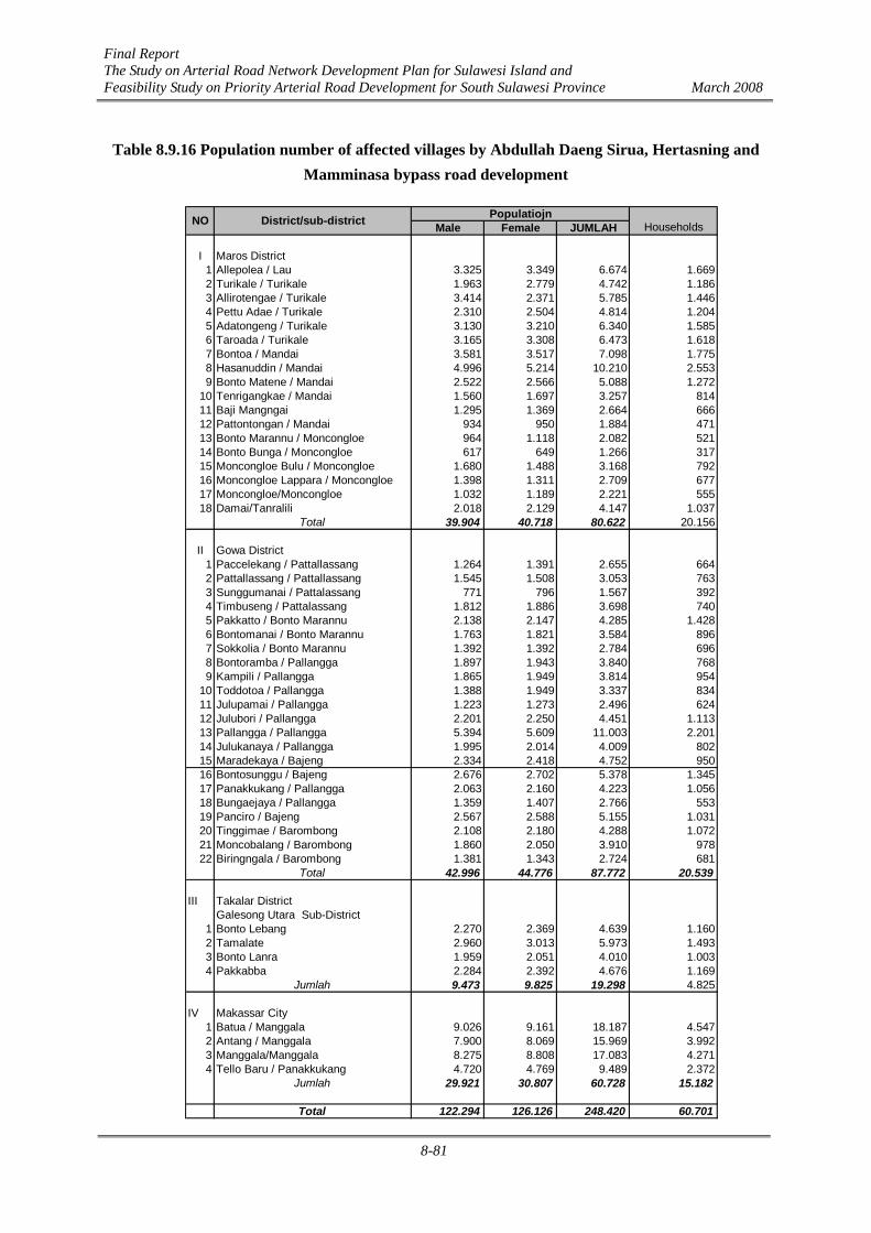
Final Report The Study on Arterial Road Network Development Plan for Sulawesi Island and Feasibility Study on Priority Arterial Road Development for South Sulawesi Province March 2008
8-81
Table 8.9.16 Population number of affected villages by Abdullah Daeng Sirua, Hertasning and Mamminasa bypass road development
Male Female JUMLAH
I Maros District1 Allepolea / Lau 3.325 3.349 6.674 1.6692 Turikale / Turikale 1.963 2.779 4.742 1.1863 Allirotengae / Turikale 3.414 2.371 5.785 1.4464 Pettu Adae / Turikale 2.310 2.504 4.814 1.2045 Adatongeng / Turikale 3.130 3.210 6.340 1.5856 Taroada / Turikale 3.165 3.308 6.473 1.6187 Bontoa / Mandai 3.581 3.517 7.098 1.7758 Hasanuddin / Mandai 4.996 5.214 10.210 2.5539 Bonto Matene / Mandai 2.522 2.566 5.088 1.272
10 Tenrigangkae / Mandai 1.560 1.697 3.257 81411 Baji Mangngai 1.295 1.369 2.664 66612 Pattontongan / Mandai 934 950 1.884 47113 Bonto Marannu / Moncongloe 964 1.118 2.082 52114 Bonto Bunga / Moncongloe 617 649 1.266 31715 Moncongloe Bulu / Moncongloe 1.680 1.488 3.168 79216 Moncongloe Lappara / Moncongloe 1.398 1.311 2.709 67717 Moncongloe/Moncongloe 1.032 1.189 2.221 55518 Damai/Tanralili 2.018 2.129 4.147 1.037
Total 39.904 40.718 80.622 20.156
II Gowa District1 Paccelekang / Pattallassang 1.264 1.391 2.655 6642 Pattallassang / Pattallassang 1.545 1.508 3.053 7633 Sunggumanai / Pattalassang 771 796 1.567 3924 Timbuseng / Pattalassang 1.812 1.886 3.698 7405 Pakkatto / Bonto Marannu 2.138 2.147 4.285 1.4286 Bontomanai / Bonto Marannu 1.763 1.821 3.584 8967 Sokkolia / Bonto Marannu 1.392 1.392 2.784 6968 Bontoramba / Pallangga 1.897 1.943 3.840 7689 Kampili / Pallangga 1.865 1.949 3.814 954
10 Toddotoa / Pallangga 1.388 1.949 3.337 83411 Julupamai / Pallangga 1.223 1.273 2.496 62412 Julubori / Pallangga 2.201 2.250 4.451 1.11313 Pallangga / Pallangga 5.394 5.609 11.003 2.20114 Julukanaya / Pallangga 1.995 2.014 4.009 80215 Maradekaya / Bajeng 2.334 2.418 4.752 95016 Bontosunggu / Bajeng 2.676 2.702 5.378 1.34517 Panakkukang / Pallangga 2.063 2.160 4.223 1.05618 Bungaejaya / Pallangga 1.359 1.407 2.766 55319 Panciro / Bajeng 2.567 2.588 5.155 1.03120 Tinggimae / Barombong 2.108 2.180 4.288 1.07221 Moncobalang / Barombong 1.860 2.050 3.910 97822 Biringngala / Barombong 1.381 1.343 2.724 681
Total 42.996 44.776 87.772 20.539
III Takalar DistrictGalesong Utara Sub-District
1 Bonto Lebang 2.270 2.369 4.639 1.1602 Tamalate 2.960 3.013 5.973 1.4933 Bonto Lanra 1.959 2.051 4.010 1.0034 Pakkabba 2.284 2.392 4.676 1.169
Jumlah 9.473 9.825 19.298 4.825
IV Makassar City1 Batua / Manggala 9.026 9.161 18.187 4.5472 Antang / Manggala 7.900 8.069 15.969 3.9923 Manggala/Manggala 8.275 8.808 17.083 4.2714 Tello Baru / Panakkukang 4.720 4.769 9.489 2.372
Jumlah 29.921 30.807 60.728 15.182
Total 122.294 126.126 248.420 60.701
HouseholdsNO District/sub-district Populatiojn
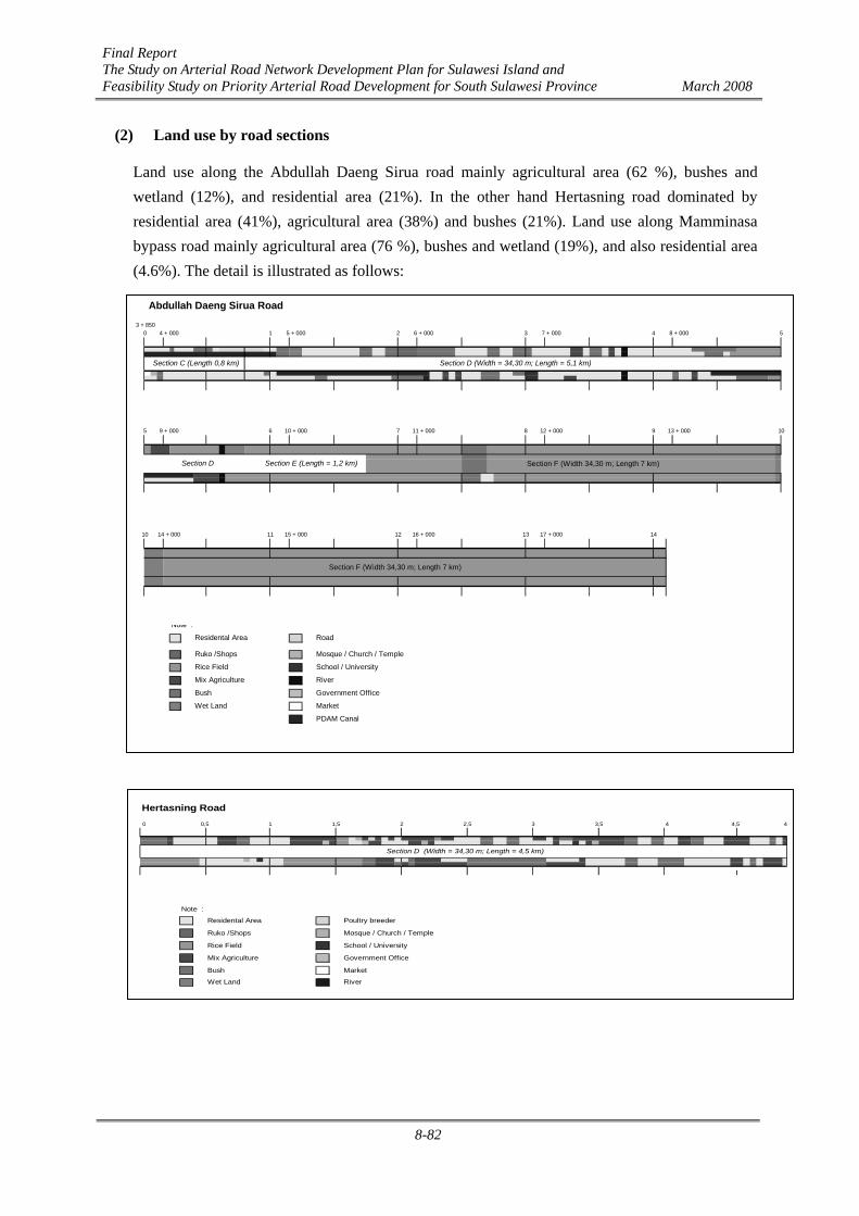
Final Report The Study on Arterial Road Network Development Plan for Sulawesi Island and Feasibility Study on Priority Arterial Road Development for South Sulawesi Province March 2008
8-82
(2) Land use by road sections
Land use along the Abdullah Daeng Sirua road mainly agricultural area (62 %), bushes and wetland (12%), and residential area (21%). In the other hand Hertasning road dominated by residential area (41%), agricultural area (38%) and bushes (21%). Land use along Mamminasa bypass road mainly agricultural area (76 %), bushes and wetland (19%), and also residential area (4.6%). The detail is illustrated as follows:
Abdullah Daeng Sirua Road
Section F (Width 34,30 m; Length 7 km)
Section F (Width 34,30 m; Length 7 km)
Note :
Residental Area Road
Ruko /Shops Mosque / Church / Temple
Rice Field School / University
Mix Agriculture River
Bush Government Office
Wet Land Market
PDAM Canal
9 105
51 2 3 4 8 + 0005 + 000 6 + 000 7 + 0003 + 850
0
9 + 000 6 7 8
Section E (Length = 1,2 km)
11 12 13
Section D
4 + 000
17 + 000
13 + 000
14
12 + 000
10 14 + 000 15 + 000 16 + 000
10 + 000 11 + 000
Section C (Length 0,8 km) Section D (Width = 34,30 m; Length = 5,1 km)
Hertasning Road0 0,5 4 4,5 4
Note :
Residental Area Poultry breeder
Ruko /Shops Mosque / Church / Temple
Rice Field School / University
Mix Agriculture Government Office
Bush Market
Wet Land River
Section D (Width = 34,30 m; Length = 4,5 km)
1 2 2,5 3 3,51,5

Final Report The Study on Arterial Road Network Development Plan for Sulawesi Island and Feasibility Study on Priority Arterial Road Development for South Sulawesi Province March 2008
8-83
Mamminasa Bypass
0,744
Before Maros City
After Maros City Start Section -North (Length = 40 m ; Width = 9,1 km)
Start Section - North (Length = 40 m ; Width = 9,1 km) Middle - Section (22 km)
Middle Section (Width = 40 m; Length = 22 km)
Middle Section (Width = 40 m; Length = 22 km)
Middle Section (Width = 40 m; Length = 22 km)
Middle Section (Width = 40 m; Length = 22 km)
Middle Section (Length = 22 km) Last Section - South (Width = 40 m; Length = 16,8 km)
Last Section - South (Width = 40 m; Length = 16,8 km)
Last Section - South (Width = 40 m; Length = 16,8 km)
Last Section - South (Width = 40 m; Length = 16,8 km)
Note :
Residental Area Road
Ruko /Shops Mosque / Church / Temple
Rice Field School / University
Mix Agriculture Government Office
Bush Market
Wet Land River
1915 16 17 18
9
10 11 12 13 14
5 6 7 8
30 31 32 33
4 50 1 2 3
10
15
20
25
48
3837
45 46 47
45
48,334
30
3534
40
24
25 26 27 28 29
20 21 22 23
39
40 41 42 43 44
35 36
0 0,5
Figure 8.9.4 Illustration of land use in Abdullah Daeng Sirua, Hertasning and Mamminasa bypass road

Final Report The Study on Arterial Road Network Development Plan for Sulawesi Island and Feasibility Study on Priority Arterial Road Development for South Sulawesi Province March 2008
8-84
(3) Required Land Acquisition and Resettlement
Required land area in total is 6,650,000 m2 atau 665 ha. The land use survey resulted the land size by land use category as follows
a. Residential Area 704,800 m2 or 70.48 ha
b. Agricultural Land 4,690,500 m2 or 469.05 ha
c. Bush = 991,000 m2 or 99.10 ha
d. Wet land = 192,450 m2 or 19.245 ha
e. Others (canal of PDAM) = 71,250 m2 or 7.125 ha
The land area by land use category for each road is presented in the following table.
Table 8.9.17 Land use Category by Road development Plan
Land Land use Category Length (m) Width (m)Total (m2) Persentage (%)
1 Total 49000 40 19600002 Residental Area 2500 40 100000 5.103 Agricultural Area 37000 40 1480000 75.514 Bush 8000 40 320000 16.335 Forest Land - 40 0 0.006 Wet Land 1500 40 60000 3.06
100.00
1 Total 17800 25 4450002 Residental Area 4000 25 100000 22.473 Agricultural Area 10900 25 272500 61.244 Bush 1250 25 31250 7.025 Forest Land 0 25 - -6 Wet Land 550 25 13750 3.097 PDAM Canal 1100 25 27500 6.18
1 Total 4900 34 1666002 Residental Area 2100 34 71400 42.863 Agricultural Area 1800 34 61200 36.734 Bush 1000 34 34000 20.415 Forest Land 0 - 0 -6 Wet Land 0 - 0 -
2571600271400 10.55
1813700 70.53385250 14.98
73750 2.8727500 1.07
Wet LandPDAM Canal
Residental AreaAgricultural AreaBushForest Land
A. Mamminasa Bypass
B. Abdullah Daeng Sirua Road
C. Hertasning Road
D. Total

Final Report The Study on Arterial Road Network Development Plan for Sulawesi Island and Feasibility Study on Priority Arterial Road Development for South Sulawesi Province March 2008
8-85
(3) Project Affected Buildings
Buildings inventory in the location of Mamminasa Bypass, Abdullah Daeng Sirua Road and Hertasning Road is divided into four types, which are houses, shops, public buildings and street vendors. These four types of buildings will be divided again based on category as follow:
a. Residential Houses is divided to 3 (three) categories, which are permanent, semi permanent and emergency/temporary buildings.
b. Shops is divided to 3 (three) categories, which are permanent, semi permanent and temporary buildings.
c. Public facility is divided to 4 (four) categories, which are governmental office, school, hospital/public health care and praying facility buildings.
d. Street Vendors Kiosks
Based on inventory result on site, number of buildings that affected by project are 669 units in total, which consist of 544 houses, 97 shops and 16 public facilities. Total number of buildings directly affected by the project is 657 units.
Table 8.9.18 Number and kind of buildings along the Abdullah Daeng Sirua, Hertasning and Bypass Mamminasa roads which are directly affected by the projects
Permanent SemiPermanent
TemporaryDwelling Total Permanent Semi
Permanent Temporary TotalShops
Goverment Office School Hospital/
ClinicReligionsBuilding Total
12 63 130 205 20 37 6 63 0 3 1 4 8 610 121 12 143 10 15 0 25 1 3 0 4 8 63 20 33 56 1 7 1 9 0 0 0 0 0 0
404 97 16 12
RoadsKind of Buildings
Houses Shops Public Buildings StreetVendors
Houses/Rumah Shops/Toko-Ruko lic buildings/Sarana Pu
Abd, Dg. SiruaHertasning
Mammimasa by passTotal
Number of buildings in location on Hertasning Road is the most compacted part or the larger number of buildings that need to be acquited, then Abdullah Daeng Sirua Road because widened of the existing road. Section Mamminasa Bypass is new road development which mostly located in agriculture area, bush and swamp. Number of each building can be seen in following figures.
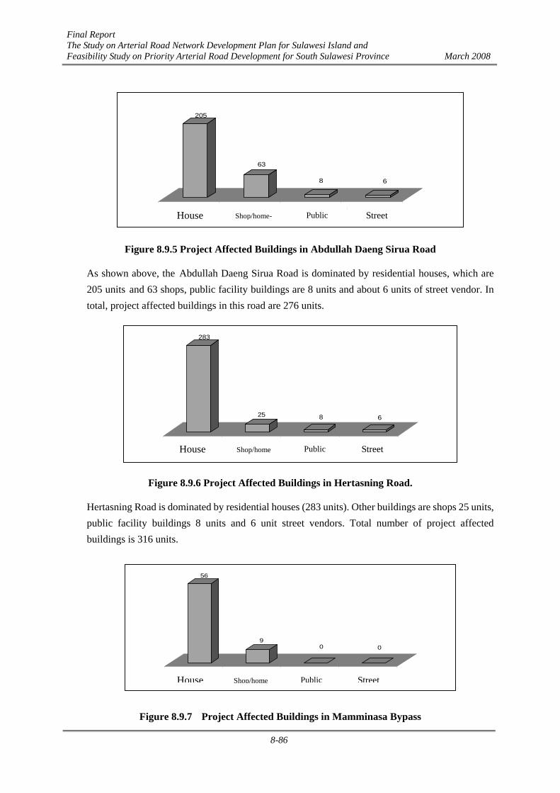
Final Report The Study on Arterial Road Network Development Plan for Sulawesi Island and Feasibility Study on Priority Arterial Road Development for South Sulawesi Province March 2008
8-86
Figure 8.9.5 Project Affected Buildings in Abdullah Daeng Sirua Road
As shown above, the Abdullah Daeng Sirua Road is dominated by residential houses, which are 205 units and 63 shops, public facility buildings are 8 units and about 6 units of street vendor. In total, project affected buildings in this road are 276 units.
Figure 8.9.6 Project Affected Buildings in Hertasning Road.
Hertasning Road is dominated by residential houses (283 units). Other buildings are shops 25 units, public facility buildings 8 units and 6 unit street vendors. Total number of project affected buildings is 316 units.
Figure 8.9.7 Project Affected Buildings in Mamminasa Bypass
205
63
8 6
Rumah Toko/Ruko Sarana Publik Pedagang KakiLimaHouse Shop/home- Public Street
283
25 8 6
Rumah Toko/Ruko Sarana Publik Pedagang KakiLimaHouse Shop/home Public Street
56
90 0
Rumah Toko/Ruko Sarana Publik Pedagang KakiLimaHouse Shop/home Public Street

Final Report The Study on Arterial Road Network Development Plan for Sulawesi Island and Feasibility Study on Priority Arterial Road Development for South Sulawesi Province March 2008
8-87
Project affected building in Mamminasa Bypass is dominated by houses (56 units) and 9 unit shops. Total number of project affected buildings in this road is 65 units.
Mamminasa Bypass, Abdullah Daeng Sirua and Hertasning Road Development Plan pass through 4 (four) District/municipality, which are Maros District, Makassar City, Gowa District and Takalar District.
Administratively, this road section is located in Daeng Sirua Road plan only in Makassar City (Manggala Sub-District. Hertasning road only in Gowa District (Pattallasang, and Somba Opu Sub-Districts). Mamminasa by pass pass through Maros District, (Turikale and Tanralili Sub-Districts), Gowa District (Pattallasang, Bontomarannu, Palangga, Bajeng, and Barombong Sub-Districts) and Takalar District (Galesong Utara Sub-District). Total number of project affected buildings in Makassar City are 282 units ( Daeng Sirua Road). Total number of project affected buildings in Gowa district is 381 units (322 units along Hertasning road and 49 units along Bypass Mamminasa road). Total number of project affected buildings in Maros district is 16 units (along Bypass Mamminasa road). While in Takalar District there is no affected building. Number of project affected buildings by districts for each road is presented in table as follows:
Table 8.9.19 Number and Kinds of Buildings Affected by Projects in each District
Abd. Daeng Sirua road
Permanent SemiPermanent
TemporaryDwelling
TotalHouse Permanent Semi
Permanent Temporary TotalShops
GovermentOffice School Hospital/
ClinicReligionsBuilding Total
Manggala 12 63 130 205 20 37 6 63 0 3 1 4 8 6
12 63 130 205 20 37 6 63 0 3 1 4 8 6
Hertasnign road
Permanent SemiPermanent
TemporaryDwelling
TotalHouse Permanent Semi
Permanent Temporary TotalShops
GovermentOffice School Hospital/
ClinicReligionsBuilding Total
Somba Opu 1 23 8 32 1 2 0 3 0 0 0 0 0 2Pattalassang 9 98 144 251 9 13 0 22 1 3 0 4 8 4
10 121 152 283 10 15 0 25 1 3 0 4 8 6
Bypass Mamminasa road
Permanent SemiPermanent
TemporaryDwelling
TotalHouse Permanent Semi
Permanent Temporary TotalShops
GovermentOffice School Hospital/
ClinicReligionsBuilding Total
MAROS TOTAL 0 8 2 10 1 4 1 6 0 0 0 0 0 0Maros Baru 0 0 1 1 1 1 0 2 0 0 0 0 0 0
Turikale 0 6 1 7 0 3 1 4 0 0 0 0 0 0Tanralili 0 2 0 2 0 0 0 0 0 0 0 0 0 0
GOWA TOTAL 3 12 31 46 0 3 0 3 0 0 0 0 0 0Barombong 0 0 3 3 0 0 0 0 0 0 0 0 0 0
Bajeng 2 0 10 12 0 1 0 1 0 0 0 0 0 0Pallangga 1 4 6 11 0 2 0 2 0 0 0 0 0 0
Bontomarannu 0 4 6 10 0 0 0 0 0 0 0 0 0 0
Pattalassang 0 4 6 10 0 0 0 0 0 0 0 0 0 0TAKALAR TOTAL 0 0 0 0 0 0 0 0 0 0 0 0 0 0
GalesongUtara 0 0 0 0 0 0 0 0 0 0 0
3 20 33 56 1 7 1 9 0 0 0 0 0 0
544 97 16 12
District/Municipality Sub District
Kind of BuildingHouse Shop Public Building
StreetVendor
MAKASSAR
Grand TOTAL
District/Municipality Sub District
Kind of BuildingHouse Shop Public Building
StreetVendor
GOWA
Grand TOTAL
District/Municipality Sub District
Kind of BuildingHouse Shop Public Building
StreetVendor
lic Buildings /Sarana Pu
Grand TOTAL
Total House /rumah Shops/ Toko
(4) Results of Interview Survey
Socio-economic, cultural, and community health data were obtained through a series of questionnaire interviews of the people in the communities along the planned road sections of the

Final Report The Study on Arterial Road Network Development Plan for Sulawesi Island and Feasibility Study on Priority Arterial Road Development for South Sulawesi Province March 2008
8-88
Mamminasa Bypass, Abdullah Daeng Sirua Road, and Hertasning Road. The total number of respondents was 40 including 10% of the households that will be subject to the direct impacts of this project (residents of the planned road development areas).
The number of respondents in each district/city was not always the same because of the difference in the number of villages in the respective regency/city where the planned roads pass through. As a result, the number of samples/respondents for the Hertasning Road was the largest because this road passes through the largest number of villages, and that for the Mamminasa Bypass was the smallest because this road passes through ten villages only.
Table 8.9.20 Number of Respondents in Project Area No Road Section Number of Respondents
1 Mamminasa Bypass 10
2 Abdullah Daeng Sirua Road 14
3 Hertasning Road 16
Total 40
Source: Interview Survey, 2007
Table 8.9.21 Number of Respondents byAge Group
No Age Group (Year) Respondent Percentage (%)
1 ≤ 19 1 2,5
2 20 – 39 6 15
3 40 – 59 22 55
4 ≥ 60 11 27,5
Total 40 100
Source: Interview Survey, 2007
Table 8.9.21 shows that the dominant age group of respondents (householders) in the planned road sections of the Mamminasa Bypass, Abdullah Daeng Sirua Road, and Hertasning Road is 40 - 59 years.
Table 8.9.22 Educational Background of Respondents
No Education Background Level Respondent Percentage (%)
1 Drop-Out 19 47,5
2 Elementary 13 32,5
3 Junior High School 5 12,5
4 Senior High School 2 5
5 University 1 2,5
Total 40 100
Source: Analyzed Primary Data, 2007

Final Report The Study on Arterial Road Network Development Plan for Sulawesi Island and Feasibility Study on Priority Arterial Road Development for South Sulawesi Province March 2008
8-89
Table 8.9.22 shows that the educational level of the respondents within the study area is relatively varied. Respondents with drop out background are dominant, and those with university graduation background are rare in the project site.
Table 8.9.23 Status of Respondents’ Residency
No Residency Status (%) Respondent Percentage (%)
1 Ownership 40 100
2 Contract 0 0
3 Stay 0 0
Total 40 100
Source: Analyzed Primary Data, 2007
Table 8.9.23 shows that most residents of the areas along the planned road sections of the Mamminasa Bypass, Abdullah Daeng Sirua Road, and Hertasning Road own lands. Table 8.9.24 shows that the function of respondents’ houses is dominantly for living. There are relatively many living-business places where the planned roads sections of the Mamminasa Bypass, Abdullah Daeng Sirua Road, and Hertasning Road pass through, but places for business solely are rarely found in the study area.
Table 8.9.24 Function of Respondents’ Houses
No House Function Respondent Percentage (%)
1 Place of Living 30 75
2 Place of Living and Business 10 25
3 Others 0 0
Total 40 100
Source: Analyzed Primary Data, 2007
Table 8.9.25 Livelihood Type of Respondents
No Livelihood Respondent Percentage (%)
1 Merchant 5 12,5
2 Officer/Police/Army 1 2,5
3 Private Office 4 10
4 Retirement 0 0
5 Craftsman 4 10
6 Labor 3 7,5
7 Peasant 14 35
8 Others 9 22,5
Total 40 100
Source: Analyzed Primary Data, 2007

Final Report The Study on Arterial Road Network Development Plan for Sulawesi Island and Feasibility Study on Priority Arterial Road Development for South Sulawesi Province March 2008
8-90
Table 8.9.25 shows the various types of respondents livelihood. Mainly, the livelihood of the people in the regencies/cities includes peasant, merchant, private officer, craftsman, labor, and officer/police/army. The dominant livelihood is peasant, and people in the retirement and officer/police/army categories are very rarely found in the project site.
Table 8.9.26 Respondents’ Income Level
No Income Level (Rp) Respondent Percentage (%)
1 < 300.000 3 7,5
2 300.000 – 673.200 3 7,5
3 > 673.200 34 85
Total 40 100
Source: Analyzed Primary Data, 2007
Table 8.9.26 shows that the income level of respondents is very varied and is dominantly above the Provincial Minimum Wage of Rp. 673,200. The respondents’ income varies from Rp. 250,000 to Rp. 3,000,000 and trading activity is the biggest income source of the respondents. As a whole, the average income of respondents is above the Provincial Minimum Wage, reaching as much as Rp. 1,038,750 per month.
The perception of the community on road section development plan for the Mamminasa Bypass, Abdullah Daeng Sirua Road, and Hertasning Road need to be seriously considered because it is highly related to the successful of upcoming activities. The posture of the community here means its agreement to the project planning, and perception means the assessment and reaction of the community to the project planning.
Agree92%
Disagree8%
Figure 8.9.8 Behavior of Community toward Project Planning
Figure 8.9.8 demonstrates that the majority of communities agree with the road section development plan for the Mamminasa Bypass, Abdullah Daeng Sirua Road, and Hertasning Road and only a few of them disagree with the project planning. The knowledge of the community is highly related to these answers because most of the communities which do not agree consider the problem of compensation for houses/land as the main reason.
Final Report The Study on Arterial Road Network Development Plan for Sulawesi Island and Feasibility Study on Priority Arterial Road Development for South Sulawesi Province March 2008
8-91
8.9.3 Summary of Impacts under AMDAL Impact Matrix
The following table summarizes the impacts under the AMDAL impact matrix, showing the major impacts during the pre-construction, construction and post-construction stages of the Mamminasa Bypass and 2 other roads.
Table 8.9.27 The Matrix of Hypothetical Significant Impact of Mamminasa Bypass and Two Other Roads
Pre
Constructio
n Period
Construction Period
Post
Construction
Period
No
Activity Period
Environment Component
Re-
mea
sure
men
t
Land
Acq
uisi
tion
qp M
obiliz
atio
n
Empl
oym
ent
Proc
urem
ent
Util
ity M
obiliz
atio
n
Venu
e C
lean
sing
Roa
d/Br
idge
Con
stru
ctio
n Fa
cilit
y/In
frast
ruct
ure
Con
stru
ctio
n
Ope
ratio
nal
Mai
nten
ance
I CHEMISTRY - PHYSICS COMPONENT
1. Air Quality - P - P - P 2. Hydrology - P 3. Water Quality - P 4. Road Infrastructure - P 5. Traffic Flow - P - P - P + P - TP 6. Spatial, Terrain and Land - TP
II BIOLOGY COMPONENT - P - P 1. Flora - P 2. Fauna
III SOCIO CULTURAL – PUBLIC HEALTH COMPONENT - P
1. People Perception 2. Working Opportunity - TP - P - P + P 3. Social Interaction + P 4. Historical Heritage - TP 5. Public Health - P - P - P 6. Median / Esthetic + P
Category : P = Important - = Negative Impact
TP = Not Important + = Positive Impact

Final Report The Study on Arterial Road Network Development Plan for Sulawesi Island and Feasibility Study on Priority Arterial Road Development for South Sulawesi Province March 2008
8-92
8.10 Environmental Management Plan (RKL)
Effective environmental management during the pre-construction and construction stages requires the establishment of effective institutional arrangements for the implementation of the Environmental Management Plan (EMP or RKL in Indonesia). In general, any environmental management programme should be carried out as an integrated part of project planning and its execution, making a significant and continuous contribution to the overall development of the scheme. It must not be regarded merely as an activity limited to monitoring and regulating activities using a pre-determined checklist of required actions. Rather, it must interact dynamically as the project implementation proceeds, dealing flexibly with environmental impacts – both expected and unexpected as they arise. For this reason, the plan provides for periodic audits, which will evaluate compliance of on-site environmental management practices with the EMP requirements and also to refocus the plan itself in the light of experience and issues arising. The following is the proposed RKL for the Trans-Sulawesi Mamminasata Section Project.

Final Report The Study on Arterial Road Network Development Plan for Sulawesi Island and Feasibility Study on Priority Arterial Road Development for South Sulawesi Province March 2008
8-93
Table 8.10.1 Environmental Management Plan (RKL) for Trans-Sulawesi Mamminasata Section ENVIRONMENT MANAGEMENT PLAN
AFFECTED PARAMETER / COMPONENT
OF ENVIRONMENT
SOURCE OF IMPACT
STANDARD PARAMETER OF IMPACT
OBJECTIVE OF ENVIRONMENT MANAGEMENT
PLAN
ENVIRONMENT MANAGEMENT
LOCATION OF ENVIRONMENT MANAGEMENT
PERIOD OF ENVIRONMENT MANAGEMENT
INSTITUTION OF ENVIRONMENT MANAGEMENT No.
1 2 3 4 5 6 7 8
I. PRE-CONSTRUCTION PERIOD 1. Land Acquisition Disquiet of land
owners which incurs the road location.
The land acquisition activity for the importance of Maros – Takalar road development.
The presence of land owners’ fretfulness (fearfulness?) in the area of Maros – Takalar road.
Avoid the presence of land owners’ fretfulness in the area of Maros – Takalar road.
Asking the local Mayor/Regent to establish the Land Acquisition Committee P2T which is attended by local community leaders.
Doing socialization in every period of land acquisition activity.
Giving compensation to the land and building owners at appropriate prices.
The location of management is the Maros – Takalar road.
The period of environment management will be implemented before the engagement of Maros – Takalar road construction period.
• The Organizer of Environment Management: The organizing institution of environment management is the project proponent, i.e. the Proponent and Administrator of Maros – Takalar road.
• The Supervisor of Environment Management: The supervising institution of environment management includes the General Directorate of Highways, Department of Public Works and Board of Environment Impact Monitoring South Sulawesi Province.
• Reporting the Result of Environment Management: The report on environment management results is submitted to the General Directorate of Highways, Department of Public Works, and Board of Environment Impact Monitoring South Sulawesi Province once every six months.

Final Report The Study on Arterial Road Network Development Plan for Sulawesi Island and Feasibility Study on Priority Arterial Road Development for South Sulawesi Province March 2008
8-94
ENVIRONMENT MANAGEMENT PLAN
AFFECTED PARAMETER /
COMPONENT OF ENVIRONMENT
SOURCE OF IMPACT
STANDARD PARAMETER OF IMPACT
OBJECTIVE OF ENVIRONMENT MANAGEMENT
PLAN
ENVIRONMENT MANAGEMENT
LOCATION OF ENVIRONMENT MANAGEMENT
PERIOD OF ENVIRONMENT MANAGEMENT
INSTITUTION OF ENVIRONMENT MANAGEMENT No.
1 2 3 4 5 6 7 8
II. CONSTRUCTION PERIOD 1. Material Mobilization • Transportation
infrastructures where transportation vehicles pass.
Dust in the community settlements in surrounding area of Maros – Takalar road.
Safety of other road users, especially along the Maros – Takalar road.
Material transportation for the importance and needs of Maros – Takalar road development.
• Breakage of road infrastructures.
• Change of air quality that exceeds the regulated quality standard.
• Presence of traffic accidents on the road where transportation vehicles pass.
• To reduce the breakage risk of road infrastructures where the transportation vehicles pass.
• To minimize the dust concentration in surrounding areas of the road where transportation vehicles pass.
• To avoid traffic accidents
Adjusting the transported material volume with the road capacity, and improving the breakage of roads due to material transportation activities.
Closing the transported material with plastic mat and sprinkling water on roads to minimize floating dust.
Reducing the vehicles’ speed when they pass the populated settlement area.
The location of environment management is the Maros – Takalar road.
Environment management will be implemented during the material transportation activities.
• The Organizer of Environment Management: The organizing institution of environment management is the project proponent, i.e. the Administrator of Maros – Takalar road development.
• The Supervisor of Environment Management: The supervising institution of environment management includes the Project Proponent and Board of Environment Impact Monitoring South Sulawesi Province.
• Reporting the Result of Environment Management: The report on environment management results is submitted to the Board of Environment Impact Monitoring South Sulawesi Province once every six months.
Final Report The Study on Arterial Road Network Development Plan for Sulawesi Island and Feasibility Study on Priority Arterial Road Development for South Sulawesi Province March 2008
8-95
ENVIRONMENT MANAGEMENT PLAN
AFFECTED PARAMETER / COMPONENT
OF ENVIRONMEN
T
SOURCE OF IMPACT
STANDARD PARAMETER OF IMPACT
OBJECTIVE OF ENVIRONMENT MANAGEMENT
PLAN
ENVIRONMENT MANAGEMENT
LOCATION OF ENVIRONMENT MANAGEMENT
PERIOD OF ENVIRONMENT MANAGEMENT
INSTITUTION OF ENVIRONMENT MANAGEMENT No.
1 2 3 4 5 6 7 8
2. Road and Bridge Construction
Existence of water pools.
Increasing noise level.
Decreasing air quality level.
Construction of Maros – Takalar road development.
The perception of community, especially for the people in the surrounding area of Maros – Takalar road.
To minimize the impacts created by the road and bridge construction of Maros – Takalar road.
• Accentuating the drainage channels construction.
• Arranging the erection schedule (only during the working time)
• Doing periodical water sprinkling in areas with potentiality of creating dust.
The Maros – Takalar road.
Environment management will be implemented before and during the road and bridge construction of Maros – Takalar road.
• The Organizer of Environment Management: The organizing institution of environment management is the project proponent, i.e. the Administrator of Maros – Takalar road development.
• The Supervisor of Environment Management: The supervising institution of environment management is the Project Proponent.
• Reporting the Result of Environment Management: The report on environment management results is submitted to the Project Proponent and Board of Environment Impact Monitoring South Sulawesi Province once every six months.
Final Report The Study on Arterial Road Network Development Plan for Sulawesi Island and Feasibility Study on Priority Arterial Road Development for South Sulawesi Province March 2008
8-96
ENVIRONMENT MANAGEMENT PLAN
AFFECTED PARAMETER / COMPONENT
OF ENVIRONMEN
T
SOURCE OF IMPACT
STANDARD PARAMETER OF IMPACT
OBJECTIVE OF ENVIRONMENT MANAGEMENT
PLAN
ENVIRONMENT MANAGEMENT
LOCATION OF ENVIRONMENT MANAGEMENT
PERIOD OF ENVIRONMENT MANAGEMENT
INSTITUTION OF ENVIRONMENT MANAGEMENT No.
1 2 3 4 5 6 7 8
3. Facility and Infrastructure Construction Works • The safety of
road users. • Aesthetics of
Maros – Takalar road.
Supporting facility and infrastructure construction works such as overpass construction, road signs installment, tree planting, etc. of Maros – Takalar road development.
The perception of road users and community in the surrounding area of Maros – Takalar road.
To avoid the presence of negative impacts and to develop the positive impacts of Maros – Takalar road development activities.
• Implementing the overpass construction in the strategic locations based on the current standard.
• Enforcing better regulation for Maros – Takalar road areas.
The Maros – Takalar road.
Environment management will be implemented during the facility and infrastructure construction works.
• The Organizer of Environment Management: The organizing institution of environment management is the project proponent, i.e. the Administrator of Maros – Takalar road development.
• The Supervisor of Environment Management: The supervising institution of environment management includes the Project Proponent and Board of Environment Impact Monitoring South Sulawesi Province.
• Reporting the Result of Environment Management: The report on environment management results is submitted to the Project Proponent and Board of Environment Impact Monitoring South Sulawesi Province once every six months.

Final Report The Study on Arterial Road Network Development Plan for Sulawesi Island and Feasibility Study on Priority Arterial Road Development for South Sulawesi Province March 2008
8-97
ENVIRONMENT MANAGEMENT PLAN
AFFECTED PARAMETER / COMPONENT
OF ENVIRONMEN
T
SOURCE OF IMPACT
STANDARD PARAMETER OF IMPACT
OBJECTIVE OF ENVIRONMENT MANAGEMENT
PLAN
ENVIRONMENT MANAGEMENT
LOCATION OF ENVIRONMENT MANAGEMENT
PERIOD OF ENVIRONMENT MANAGEMENT
INSTITUTION OF ENVIRONMENT MANAGEMENT No.
1 2 3 4 5 6 7 8
III. POST-CONSTRUCTION 1. Operational of Maros – Takalar Road Continuity of
transportation system.
Operational activities of Maros – Takalar road with 58 km length.
The perception of community as road users along the Maros – Takalar road.
• To simplify the traffic flow, especially for the vehicles that shouldn’t enter the city centers through which they pass..
• To reduce traffic accidents.
• To locate officer to manage the traffic flow diversion.
Traffic signs installment which can guide the road users, especially for those who do not need to enter the city centers through which vehicles pass.
The Maros – Takalar road.
To be implemented in continuity during the operational stage of Maros – Takalar road.
• The Organizer of Environment Management: The organizing institution of environment management is the road users of Maros – Takalar road development.
• The Supervisor of Environment Management: The supervising institution of environment management is the Project Proponent
• Reporting the Result of Environment Management: The report on environment management results is submitted to the Project Proponent and Board of Environment Impact Monitoring South Sulawesi Province once every six months.

Final Report The Study on Arterial Road Network Development Plan for Sulawesi Island and Feasibility Study on Priority Arterial Road Development for South Sulawesi Province March 2008
8-98
ENVIRONMENT MANAGEMENT PLAN
AFFECTED PARAMETER / COMPONENT
OF ENVIRONMEN
T
SOURCE OF IMPACT
STANDARD PARAMETER OF IMPACT
OBJECTIVE OF ENVIRONMENT MANAGEMENT
PLAN
ENVIRONMENT MANAGEMENT
LOCATION OF ENVIRONMENT MANAGEMENT
PERIOD OF ENVIRONMENT MANAGEMENT
INSTITUTION OF ENVIRONMENT MANAGEMENT No.
1 2 3 4 5 6 7 8
2. Maintenance of Maros – Takalar Road
Aesthetics and existence of medians.
Maintenance activities of Maros – Takalar road.
The perception of road users and community in the surrounding area of Maros – Takalar road.
To develop and improve the positive impacts of Maros – Takalar road development activities.
Making maintenance efforts on surrounding area of Maros – Takalar road and keeping the existence of medians.
The Maros – Takalar road.
To be implemented as needed, during the operational stage of Maros – Takalar road.
• The Organizer of Environment Management: The organizing institution of environment management is the project proponent of Maros – Takalar road development.
• The Supervisor of Environment Management: The supervising institution of environment management includes the General Directorate of Highways, Department of Public Works and Board of Environment Impact Monitoring South Sulawesi Province.
• Reporting the Result of Environment Management: The report on environment management results is submitted to the General Directorate of Highways, Department of Public Works and Board of Environment Impact Monitoring South Sulawesi Province once every six months.

Final Report The Study on Arterial Road Network Development Plan for Sulawesi Island and Feasibility Study on Priority Arterial Road Development for South Sulawesi Province March 2008
8-99
8.11 Environmental Monitoring Plan (RPL)
The main objectives of environmental monitoring are to provide a continuous feedback on project implementation to identify actual or potential successes or problems at an early stage, and to implement timely adjustments to the whole project management work. Monitoring is a continuous assessment of project implementation and must be an integrated part of good management during the construction.
The objectives of the monitoring system are to assist the project management through:
- Defining requirements and procedures for environmental monitoring (type of equipment to be used, monitoring schedule, parameters to be monitored, and so on);
- Identifying targets and objectives for the project implementation;
- Keeping environmental records for the project evaluation;
- Identifying problems arising from the project, and figuring out procedures for the environmental remediation in the event of pollution or similar incidents; and
- Providing readily available results of related environmental analysis for decision making.
The following is the proposed RPL for the Trans-Sulawesi Mamminasata Section Project.
Final Report The Study on Arterial Road Network Development Plan for Sulawesi Island and Feasibility Study on Priority Arterial Road Development for South Sulawesi Province March 2008
8-100
Table 8.11.1 Monitoring Plan (RPL) for Trans-Sulawesi Mamminasata Section RPL
Environment Monitoring Method
Important Impact to be Monitored
Source of Impact
Environment Parameter to be Monitored
Objective of Environment
Monitoring Plan Method of Data Collection and
Analysis
Monitoring Location
Period and
frequency of Monitoring
Institution of Environment Monitoring
No.
1 2 3 4 5 6 7 8
Pre-Construction Stage 1. Land Acquisition
Disquiet of land owners which incurred the road location
Land acquisition activities for the Maros-Takalar Road development.
Incidence of disquiet of land owners which incurs the location of Maros-Takalar Road.
To know incidence of disquiet of land owners residing in the Maros-Takalar Road area.
Doing field observation and interview of the land owners incurred by road location
Maros-Takalar Road
To be executed at the time of compensatory payment, done once during compensation process.
• The Organizer of Environment Mpnitoring
The organizing institution of environment monitoring is the project proponent, i.e. the Administrator of Maros – Takalar road development.
• The Supervisor of Environment Monitoring:
The supervising institution of environment monitoring includes the Project Proponent and Board of Environment Impact Monitoring South Sulawesi Province.
• Reporting the Result of Environment Monitoring
The report on environment management results is submitted to the Board of Environment Impact Monitoring South Sulawesi Province once every six months.

Final Report The Study on Arterial Road Network Development Plan for Sulawesi Island and Feasibility Study on Priority Arterial Road Development for South Sulawesi Province March 2008
8-101
RPL Environment Monitoring Method
Important Impact to be Monitored
Source of Impact
Environment Parameter to be
Monitored
Objective of Environment
Monitoring Plan Method of Data Collection and
Analysis
Method of Collecting and Data Analysis
Method of Collecting and Data Analysis
Institution of Environment Monitoring
No.
1 2 3 4 5 6 7 8 a. The Environment Monitoring on Construction Period
CONSTRUCTION STAGE 1. Material Mobilization • Transportation
Infrastructures where transportation vehicles pass
• Dust in residential settlements around Maros-Takalar Road .
• Safety of road users especially in areas along Maros-Takalar Road
Transportation of material for the construction requirements of Maros-Takalar Road development.
• Incidence of road infrastructure damage
• Decrease of air quality exceeding the determined criteria value
• Incidence of traffic accident in the roads where transportation vehicles pass
• Decreasing the risk of damage of road infrastructures where transportation vehicles pass
• Minimizing dust concentration in the region where transportation vehicles pass
• Preventing incidence of traffic accidents.
Doing field observation and interview of the residents oaround Maros-Takalar Road and also measuring the dust level and comparing its result with Environment Criteria according to Decision of Governorof Sulsel No. 14 in 2003.
The monitoring location is Maros-Takalar Road.
To be executed at the time of material transportation, conducted once every 6 months.
• The Organizer of Environment Monitoring
The organizing institution of environment monitoring is the project proponent, i.e. the Administrator of Maros – Takalar road development.
• The Supervisor of Environment Monitoring
The supervising institution of environment monitoring includes the Project Proponent and Board of Environment Impact Monitoring South Sulawesi Province.
• Reporting the Result of Environment Monitoring
The report on environment management results is submitted to the Board of Environment Impact Monitoring South Sulawesi Province once every six months.
Final Report The Study on Arterial Road Network Development Plan for Sulawesi Island and Feasibility Study on Priority Arterial Road Development for South Sulawesi Province March 2008
8-102
RPL
Environment Monitoring Method
Important Impact to be Monitored
Source of Impact
Environment Parameter to be
Monitored
Objective of Environment
Monitoring Plan Method of Data Collection and
Analysis
Method of Collecting and Data Analysis
Method of Collecting and Data Analysis
Institution of Environment Monitoring
No.
1 2 3 4 5 6 7 8 2. Road and Bridge Construction Presence of water
suffusing Increasing noise • Decreasing air
quality
Development activities of Maros-Takalar Road.
Residents’ perception, especially those living around Maros-Takalar road areas.
Minimizing the impact caused by activities of Maros-Takalar road and bridge works.
Doing field observation and interview of the residents around Maros-Takalar Road and also measuring the noise and dust levels and comparing their results with Citeria Value of Environment according to Decision of Governor of Sulsel No. 14 in 2003.
The monitoring location is Maros-Takalar Road.
To be executed at the time of activities of road and bridge construction, conducted once every 6 months.
• The Organizer of Environment Mpnitoring
The organizing institution of environment monitoring is the project proponent, i.e. the Administrator of Maros – Takalar road development.
• The Supervisor of Environment Monitoring
The supervising institution of environment monitoring is the project proponent
• Reporting the Result of Environment Monitoning
The report on environment management results is submitted to the project proponent and the Board of Environment Impact Monitoring South Sulawesi Province once every six months.
Final Report The Study on Arterial Road Network Development Plan for Sulawesi Island and Feasibility Study on Priority Arterial Road Development for South Sulawesi Province March 2008
8-103
RPL
Environment Monitoring Method
Important Impact to be Monitored
Source of Impact
Environment Parameter to be
Monitored
Objective of Environment
Monitoring Plan Method of Data Collection and
Analysis
Method of Collecting and Data Analysis
Method of Collecting and Data Analysis
Institution of Environment Monitoring
No.
1 2 3 4 5 6 7 8 3. Structure/Infrastructure Construction - Safety of road
users - Maros-Takalar road aesthetics
Execution of bridge development, traffic equipment installation, tree cultivation, etcforMaros-Takalar Road.
Residents’ perception, especially those living around the Maros-Takalar road areas.
Preventing incidence of negative impact, and developping the positive impact from activities of supporting structure at Maros-Takalar Road.
Doing field observation and interview of the residents around Maros-Takalar Road.
The monitoring location is Maros-Takalar Road.
To be executed during activities of structure/ infrastructure construction, conducted once every 6 months.
• The Organizer of Environment Monitoring:
The organizing institution of environment monitoring is the project proponent, i.e. the Administrator of Maros – Takalar road development.
• The Supervisor of Environment Monitoring
The supervising institution of environment monitoring includes the project proponent and Board of Environment Impact Monitoring South Sulawesi Province.
• Reporting the Result of Environment Monitoring
The report on environment management results is submitted to the project proponent and the Board of Environment Impact Monitoring South Sulawesi Province once every six months.

Final Report The Study on Arterial Road Network Development Plan for Sulawesi Island and Feasibility Study on Priority Arterial Road Development for South Sulawesi Province March 2008
8-104
RPL Environment Monitoring Method
Important Impact to be Monitored
Source of Impact
Environment Parameter to be Monitored
Objective of Environment
Monitoring Plan Method of Data Collection and
Analysis
Method of Collecting and Data Analysis
Method of Collecting and Data Analysis
Institution of Environment Monitoring
No.
1 2 3 4 5 6 7 8 a. POST CONSTRUCTION STAGE
1. Operation Maros-Takalar Road Important impact of
operational activity of Maros-Takalar Road is fluidity of transportation system.
Activity of operation of Maros-Takalar Road as long as 58 km.
Perception of User Society of Maros-Takalar Road.
-To know the fluidity of traffic current, especially for vehicles which needn't enter the downtown centers in regions where vehicles pass. -Decreasing traffic accidents
Doing field observation and interview of the residents around Maros-Takalar Road.
The monitoring location is Maros-Takalar Road.
To be executed during the operational stage of Maros-Takalar Road, conducted once every 6 months.
• The Organizer of Environment Management:
The organizing institution of environment management is the project proponent
• The Supervisor of Environment Management:
The supervising institution of environment management includes the General Directorate of Highway, Department of Public Works and Board of Environment Impact Monitoring South Sulawesi Province.
• Reporting the Result of Environment Management:
The report on environment management results is submitted to the General Directorate of Highway, Department of Public Works and Board of Environment Impact Monitoring South Sulawesi Province once every six months.

Final Report The Study on Arterial Road Network Development Plan for Sulawesi Island and Feasibility Study on Priority Arterial Road Development for South Sulawesi Province March 2008
8-105
RPL Environment Monitoring Method
Important Impact to be Monitored
Source of Impact
Environment Parameter to be
Monitored
Objective of Environment
Monitoring Plan Method of Data Collection and
Analysis
Method of Collecting and Data Analysis
Method of Collecting and Data Analysis
Institution of Environment Monitoring
No.
1 2 3 4 5 6 7 8 2. Maintenance of Maros-Takalar Road
Important impact of maintenance activity of Maros-Takalar Road is aesthetics and green line existence.
Maintenance Activity of Maros-Takalar Road
Perception of User Society of Maros-Takalar Road.
To know the positive impact of development of Maros-Takalar Road.
Doing field observation and interview of the residents around Maros-Takalar Road.
The monitoring location is Maros-Takalar Road.
To be executed during the maintenace of Maros-Takalar Road, conducted once every 6 months.
• The Organizer of Environment Management:
The organizing institution of environment management is the project proponent
• The Supervisor of Environment Management:
The supervising institution of environment management includes the General Directorate of Highway, Department of Public Works and Board of Environment Impact Monitoring South Sulawesi Province.
• Reporting the Result of Environment Management:
The report on environment management results is submitted to the General Directorate of Highway, Department of Public Works and Board of Environment Impact Monitoring South Sulawesi Province once every six months.

Final Report The Study on Arterial Road Network Development Plan for Sulawesi Island and Feasibility Study on Priority Arterial Road Development for South Sulawesi Province March 2008
8-106
8.12 LARAP Policy Framework
8.12.1 Objectives
A Land Acquisition and Resettlement Action Plan (LARAP) is a document required for any project which results in the physical resettlement of people, and it must specify the procedures and actions it should take in order to properly resettle and compensate PAPs and communities. According to the basic concept of the JICA guidelines, a LARAP is required to ensure that their incomes and living standards of PAPs should be restored to at least pre-project levels and are not worse off than they would have been without the project. More specifically, a LARAP should be prepared as a detailed plan for mitigating the land acquisition impacts in an attempt:
- to ensure that the social and economic livelihood of PAPs is recovered at least the pre-project level;
- to provide policy and procedural guidelines for the acquisition of land and other assets, compensation, and resettlement;
- to identify households that will be adversely affected by the Project, where they are located, what compensation and related alleviating measures are to be provided and how and when these measures will be implemented; and
- to provide a plan on for the community participation of the PAPs could be involved in the various stages of the project, including the implementation of the RAP
Since the full-scale detailed LARAP for the Trans-Sulawesi Mamminasa Section, the priority project, will be formulated after the feasibility study, the policy framework for the LARAP was proposed.
8.12.2 Legal Basis for LARAP
The regulation which is used for execution of land acquisition for development implementation of public interest is Presidential Regulation No. 36 Year 20052 which it is implemented using Agrarian State Ministry Regulation No. 1 Year 1994 concerning Operational Directive of Presidential Decree No. 55 Year 1993. No new operational directive has been established related with the new regulation.
8.12.3 Framework for LARAP
A Land Acquisition and Resettlement Action Plan (LARAP) is a document required for any project which results in the physical resettlement of people, and it must specify the procedures and actions it should take in order to properly resettle and compensate PAPs and communities. According to the basic concept of the JICA guidelines, a LARAP is required to ensure that their incomes and living standards of PAPs should be restored to at least pre-project levels and are not worse off than they would have been without the project. More specifically, a LARAP should be prepared as a

Final Report The Study on Arterial Road Network Development Plan for Sulawesi Island and Feasibility Study on Priority Arterial Road Development for South Sulawesi Province March 2008
8-107
detailed plan for mitigating the land acquisition impacts in an attempt:
- to ensure that the social and economic livelihood of PAPs is recovered at least the pre-project level;
- to provide policy and procedural guidelines for the acquisition of land and other assets, compensation, and resettlement;
- to identify households that will be adversely affected by the Project, where they are located, what compensation and related alleviating measures are to be provided and how and when these measures will be implemented; and
- to provide a plan on for the community participation of the PAPs could be involved in the various stages of the project, including the implementation of the RAP
Since the full-scale detailed LARAP for the Trans-Sulawesi Mamminasa Section will be formulated after the feasibility study, apart from the EIA reports, in an attempt to mitigate the negative impacts by the land acquisition and resettlement, the policy framework for the LARAP was formulated. In case of formulating the final full-scale LARAP, the following contents should be included as the full-scale LARAP.
- Results of Socio-economic Survey
- Outline of Land Acquisition and Compensation Package
- Institutional Set-up for LAC (Land Acquisition Committee)
- Public Consultations
- Grievance Mechanizm
- Monitoring and Evaluation
(1) Outline of PAPs
The required acquisition for the land and structures are as follows.

Final Report The Study on Arterial Road Network Development Plan for Sulawesi Island and Feasibility Study on Priority Arterial Road Development for South Sulawesi Province March 2008
8-108
Table 8.12.1 Estimated Required Land Acquisition and structures compensation for Trans-Sulawesi Mamminasa Section
Plan Existing House ShopPublic
building Street vendor
TOTAL A 320 1.083 67 2674 6 - 8 Widening 42 Maros 283 905 40 120
Turikale 132 490 21 39Mandai 63 183 15 36Maros Baru 24 44 2 4Marusu 64 188 2 41
4 6 - 8 Widening 42 Makassar 37 178 27 147Biringkanaya 37 178 27 147MakassarBiringkanayaTamalanreaTOTAL B 92 16 2 1Makassar 92 16 2 1Mangala 43 1 0 0Panakukkang 9 0 0 1Rappocini 27 6 1 0Tamalate 13 9 1 0TOTAL C 42 10 2 3Gowa 42 10 2 3Mangasa 22 0 1 1Barombong 13 10 1 1Pallangga 7 0 0 1TOTAL D 661 374 54 37Gowa 380 239 28 7Bajeng 211 184 15 5Bontonompo 169 55 13 2Takalar 281 135 26 30GalesongUtara 41 20 2 0Polombangkeng Utara 171 46 5 22Pattalassang 69 69 19 8
58 1.115 1.483 125 308308
440.000
Total
Grand TOTAL Trans Sulawesi
4 Widening 30 0
DNational
Road
Middle Ring RoadAccess - Takalar 22 2
294.000
CKab.Road
Middle Ring Roadaccess road
9 - 4 New 40 0 360.000
8 New 42 0
Widening 42
BMunici
palRoad
Middle Ring Road 7 -
Kind of Building
ANational Road
Maros - Jl.Sutami IC
8
30 96.000
Jl. Sutami IC -middle Ring(Perintis Road)
124 8-10
WorkROW (m) Land Area
(m2)District / Municipality
2.723
Road Status Name Length(Km)
Existingroadway Plan Roadway
The section of the Perintis Road is the on-going project of the Indonesian Government, and, therefore, this section is not included in the Trans-Sulawesi Road Project. As a result, the costs for the land acquisition and resettlement required for the Perintis Road would not be included in the project cost of the Trans-Sulawesi Road Project.
(2) Eligibility and Entitlement and Compensation Policies
Eligibility as well as entitlement policy is an integral part of the RAP, since PAPs should clearly recognize the established date for eligibility as well as entitlement for the compensation of losses.
Among potential PAPs, eligibility for entitlement for compensation is determined by the establishment of a cut-off date. Cut-off date means the date prior to which the occupation or use of the Project area makes residents/users eligible to be categorized as PAPs. The establishment of the cut-off date aims at preventing the inflow of ineligible non-residents who might take advantage of the compensation policies or speculate on land values.
The compensation package includes a wide range of compensation measures like cash compensation and institutional support provided to eligible PAPs. Major compensation packages include:
- Loss of land;

Final Report The Study on Arterial Road Network Development Plan for Sulawesi Island and Feasibility Study on Priority Arterial Road Development for South Sulawesi Province March 2008
8-109
- Loss of structures;
- Loss of productive trees; and
- Loss of commune and public assets
- Allowances for socially vulnerable households
(3) Compensation Rate
The difference of the compensation unit price between the public buildings and houses/stores is derived from the locations of those facilities. (The public buildings are normally located in the center of the towns.) In addition to the compensation for these properties, the compensation for the loss of business opportunities during the resettlement or relocation should be included in the final version of the LARAP in accordance with the compensation policies of the Indonesian Government.
The amount of compensation for the land is determined based on the combination of land price for tax purposes (NJOP) and market price. According to the Regulation of Agrarian State Minister/Head of Land Agency No 1/1994 article 17, compensation for certificated land will be 100% of the agreement price, while compensation for non certificated land will be 90% of the agreement price.
According to the regulation, building and plants selling price are to be estimated by the institution responsible on that matters.
Regarding the price for buildings, the compensations will consider permission letter, year of construction and type of building structure (permanent, semi permanent, temporary). Basic price of building is determined according to the unit price of state building (A Joint Circular of BAPPENAS and Financial Department) and estimation prices are made by Building Department of the Regency.
The most important point on compensation and entitlement policies for PAPs under is the comprehensive and complete application of the concept of “Replacement Cost”.
“Replacement Cost” is defined that it is an amount needed for obtaining or replacing acquired land or property with similar land or property with equivalent or better productive capacity at current market price/value without deduction of any salvage or depreciation and take no account of the influence by development project on the value of the acquired land or property, plus the cost of transferring or registering the rights to the new land or property.
(4) Institutional Set-up
The Land Acquisition Committee (LAC) will be set up in each District/City in line with the regulation No. 36 of 2005 JO No. 65 of 2006. The duties of LAC includes

Final Report The Study on Arterial Road Network Development Plan for Sulawesi Island and Feasibility Study on Priority Arterial Road Development for South Sulawesi Province March 2008
8-110
a) conduct the research and assets inventory
b) conduct legal status and document research for the land which rights to be released
c) determine the amount of compensation
d) giving explanation to stakeholders
e) conduct deliberation
f) witness the undertaking of compensation
g) make official report of land release/assignment
h) administer and document all land provision files and submit to competent parties
(5) Budgetary Arrangement
A full itemized budget should be reviewed for all resettlement activities, including compensation for land acquisition and resettlement cost after the detailed measurement of land and structures.
(6) Public Consultation and Information Disclosure
The information disclosure and public consultations will commence prior to the marking of the alignment and will continue at all stages of decision making. The transparent information disclosure is a key to promoting effective public consultations for planning and implementation of the LARAP. In other words, keeping PAPs fully informed of their rights and obligations is crucial to the success of the implementation of the LARAP. In order to make the information understandable and accessible for all LAPAPs, relevant information should be translated into local languages, paying special attentions to accessibility of socially vulnerable groups of people.
- Definitions of terms in the LARAP
- Frequently asked questions and answers over the Project
- Detailed explanation on the Project
- Scope and categories of PAPs and predicted impacts
- Details of eligibility and entitlements under the LARAP
- Implementation schedule together with the timetable for the delivery of entitlements
- Compensation policies and rates
- Procedures for the grievance redress
- Outline of the public consultations
Generally, the following meetings and consultations will be conducted during the preparation stage

Final Report The Study on Arterial Road Network Development Plan for Sulawesi Island and Feasibility Study on Priority Arterial Road Development for South Sulawesi Province March 2008
8-111
of the LARAP.
1) Kick-off Information Campaigns before LARAP Preparation
2) Consultations during LARAP Preparation
3) Public Information Meeting after LARAP Preparation
(7) Grievance Mechanism
It is critical to allow PAPs to express their complaints or claims with assuring timely and satisfactory resolutions of those complaints or claims, when PAPs are not satisfied with the compensation and resettlement package in accordance with the formal procedure. The main objective of the grievance procedure is to provide PAPs with ample opportunities to ensure that the compensation and resettlement package proposed by the will be implemented in the accurate and fair manner. The current grievance mechanism is being individually established on ad-hoc and project basis.
(8) Monitoring and Evaluation
Monitoring for the implementation of the LARAP is of critical importance in all projects involving involuntary resettlement in terms of the following factors:
- Measurement of input indicators against proposed timetable and budget related to the contents of the compensation;
- Measurement of effectiveness of inputs against baseline indicators and assessment of PAPs’ satisfaction with inputs; and
- Measurement of output indicators such as livelihood restoration and development impacts against baseline.
In addition to internal monitoring, external monitoring is normally required to provide an independent periodic assessment of resettlement implementation and impacts, to verify internal reporting and monitoring, and to suggest adjustment of delivery mechanisms and procedures as required to function effectively.
The main indicators which should be regularly monitored are:
- Entitlements of PAPs are in accordance with the approved entitlement policies;
- Assessment of compensation is carried out in accordance with agreed procedures;
- Payment of compensation to the affected people in the various categories according to the level of compensation as described in the LARAP;
- Public information and public consultation and grievance procedures are followed as described in the LARAP; and

Final Report The Study on Arterial Road Network Development Plan for Sulawesi Island and Feasibility Study on Priority Arterial Road Development for South Sulawesi Province March 2008
8-112
- Relocation, if any, and payment of compensation are made in timely manner
The collection of monitored data as well as their evaluations should be implemented by the relevant agency by conducting regular sample surveys and etc.

Final Report The Study on Arterial Road Network Development Plan for Sulawesi Island and Feasibility Study on Priority Arterial Roads in South Sulawesi Province March 2008
9-1
CHAPTER 9 COST ESTIMATE AND PROJECT EVALUATION
9.1 Cost Estimate
9.1.1 Composition of Project Cost
The project cost consists of construction cost, detailed design and supervision cots, land acquisition and compensation cost and administration cost. The construction cost was estimated based on the result of the preliminary engineering design, quantities of major work items and assumptions on the percentages of overhead and profit of the contractor, and physical contingency. The value added tax (VAT) of 10% and inflation (price escalation) were excluded for the economic evaluation but included in the financing plan under Chapter 9,- Project Implementation Plan. The cost for periodic maintenance and routine maintenance was also estimated.
The components of the project cost are shown in Figure 9.1.1.
Figure 9.1.1 Project Cost Components
9.1.2 Conditions of Cost Estimate
Cost estimate was made based on the following conditions:
i) Time of cost estimate: May 2007
ii) Foreign currency: US dollar
iii) Exchange rate: 1 US dollar = Rp. 9,322 (Bank of Indonesia, 16 May 2007)
iv) Taxes: Not included for the economic evaluation but included in the project implementation plan as a part of the project cost.
Construction Cost
Detailed Design &Supervision Services
Land Acquisition &Compensation Cost
Direct Construction Cost
Indirect Construction Cost
Material Cost
Overhead & Profit
Labor Cost
Equipment Cost
Project Cost
Physical Contingency
Estimated by multiplying construction unit prices of each work item and quantities based on the preliminary design
Administration Cost
Those are not included in the economic evaluation but incorporated in the project implementation cost under Chapter 10
VAT 10% Price escalation (inflation)
Maintenance Cost

Final Report The Study on Arterial Road Network Development Plan for Sulawesi Island and Feasibility Study on Priority Arterial Roads in South Sulawesi Province March 2008
9-2
(1) Construction Cost
1) General
The construction cost is composed of direct construction cost, indirect construction cost and physical contingency. The direct construction cost consists of labor cost, material cost, and equipment cost. The construction cost was estimated by multiplying construction unit prices and quantities calculated based on the preliminary design, and physical contingency was considered to be 10%. Estimation was made by major work items quoted from the standard specifications of DGH, Indonesia, since they can be considered as the most general categorization of work items in this country.
2) Construction Unit Prices
Construction unit prices for every work item include direct construction cost and indirect construction cost. The direct construction cost is composed of labor cost, material cost, and equipment cost, including all the relevant expenditures necessary to conduct the work, such as taxes on the procurement of materials, operation costs of equipment and so on. The indirect construction cost includes overhead and profit margin of the contractor.
Construction unit prices applied to the cost estimate were set based on the standard unit prices in South Sulawesi Province (Harga Satuan Pokok Kegiatan (HSPK), 2006) and also on the comparison results of contract unit prices in the past and on-going projects. The sites of all the projects referred to are located in the Mamminasata area, and the contracts of which were made in the period of 2005-2007.
Unit prices of major pay items applied for cost estimation are shown in Table 9.1.1.
Table 9.1.1 Unit Prices of Major Items
Item Unit Unit Price (Rp. per unit)
Mortared Stonework m3 334,361 Common Excavation m3 25,337 Common Embankment m3 25,337 Selected Embankment m3 63,654 Aggregate Base Class A m3 230,015 Aggregate Base Class B m3 205,723 Asphalt Concrete-Wearing Course (5cm) m2 55,374 Structural Concrete Class K250 m3 659,436 Precast Unit Type I Girder (31m) nos 189,264,348 Reinforcing Steel kg 7,807
Source: JICA Study Team design
3) Indirect Construction Cost
The overhead and profit were assumed to be twenty percent (20%) of the estimated direct construction cost.

Final Report The Study on Arterial Road Network Development Plan for Sulawesi Island and Feasibility Study on Priority Arterial Roads in South Sulawesi Province March 2008
9-3
(2) Detailed Design and Supervision Services
The cost for detailed design and supervision services was assumed to be seven percent (7%) of the estimated construction cost.
(3) Land Acquisition and Compensation Cost
Fund for land acquisition and compensation would be coming from APBN and/or APBD depending on the agreement by both central and regional governments. On the basis of the current procedure of land acquisition and compensation in Indonesia, the transaction prices and Nilai Jual Objek Pajak (NJOP) prices heard from each Kota/Kabupaten, the land acquisition and compensation costs were estimated as shown in the following tables.
Table 9.1.2 Land Acquisition and Compensation Costs for Mamminasa Bypass
No. Item
Section 1-A
Maros (M Rp.)
Section 1-C
Maros (M Rp.)
Section 1-B
Maros, Gowa
(M Rp.)
Section 1-D
Gowa (M Rp.)
Total (M Rp.)
1 Land Acquisition 9,900 15,100 46,560 6,686 78,2462 Building Compensation 863 69 1,346 2,588 4,865
Total 10,763 15,169 47,906 9,274 83,111Source: JICA Study Team estimation
Table 9.1.3 Land Acquisition and Compensation Costs for Trans-Sulawesi Mamminasata Road
No. Item Section
2-A (M Rp.)
Section 2-B
(M Rp.)
Section 3-C
(M Rp.)
Section 4-D
(M Rp.)
Total (M Rp.)
1 Land Acquisition 35,256 85,260 38,592 18,627 177,7352 Building Compensation 50,457 1,639 1,639 28,868 82,603
Total 85,713 86,899 40,231 47,495 260,338Source: JICA Study Team estimation
Table 9.1.4 Land Acquisition and Compensation Costs for Hertasning Road
No. Item Section 3-End
Gowa (M Rp.)
Total (M Rp.)
1 Land Acquisition 4,865 4,865 2 Building Compensation 4,968 4,968
Total 9,833 9,833 Source: JICA Study Team estimation
Table 9.1.5 Land Acquisition and Compensation Costs for A.D. Sirua Road
No. Item
Section 4-A, C, DMakassar(M Rp.)
Section 4-E
Maros (M Rp.)
Section 4-F1
Maros (M Rp.)
Section 4-F2
Gowa (M Rp.)
Total (M Rp.)
1 Land Acquisition 26,655 978 3,125 1,183 31,9412 Building Compensation 4,796 0 138 0 4,934
Total 31,451 978 3,263 1,183 36,874Source: JICA Study Team estimation

Final Report The Study on Arterial Road Network Development Plan for Sulawesi Island and Feasibility Study on Priority Arterial Roads in South Sulawesi Province March 2008
9-4
(4) Administration Cost
The administration cost was assumed to be two percent (2%) of the estimated construction cost.
9.1.3 Project Cost
The project cost was estimated in accordance with the road sub-sections shown in Figure 9.1.2.
4-A 4-B 4-C 4-D4
4-E
4-F1
4-F2
1-A
1-C
1-B
1-D
3-End
4-D
4-D
2-A
2-C
4-D
2-B
2-D
Figure 9.1.2 Sections of the Project Road

Final Report The Study on Arterial Road Network Development Plan for Sulawesi Island and Feasibility Study on Priority Arterial Roads in South Sulawesi Province March 2008
9-5
(1) Mamminasa Bypass
The major construction quantities are shown in Table 9.1.6.
Table 9.1.6 Major Construction Quantities for Mamminasa Bypass
Item Unit Section 1-A
Section 1-C
Section 1-B
Section 1-D Total
Mortared Stonework m3 18,810 28,690 73,720 63,521 184,721
Common Excavation m3 108,331 149,454 424,152 345,040 1,026,978Common Embankment m3 270,318 375,074 1,332,351 1,021,917 2,999,660Selected Embankment m3 4,378 1,082 5,369 7,641 18,469Aggregate Base Class A m3 15,246 23,254 59,752 51,485 149,737Aggregate Base Class B m3 23,760 36,240 93,120 80,237 233,357Asphalt Concrete -Wearing & Binder Course (5cm) m2 153,748 227,396 588,176 509,736 1,479,056
Structural Concrete Class K250 m3 7,729 6,872 20,455 19,264 54,320Precast Unit Type I Girder (16-35m) nos 268 78 0 70 416Reinforcing Steel ton 33 219 944 1,100 2,296
Source: JICA Study Team design
Based on the examination on construction unit prices and quantities from the preliminary design, the construction cost was estimated as shown in Table 9.1.7.
Table 9.1.7 Construction Cost of Mamminasa Bypass Project Division
No. Item Section
1-A (M Rp.)
Section 1-C
(M Rp.)
Section 1-B
(M Rp.)
Section 1-D
(M Rp.)
Total (M Rp.) Percentage
1 General 1,540 1,580 4,909 4,384 12,413 1.9%
2 Drainage 7,573 11,549 29,672 25,568 74,361 11.6%
3 Earthworks 20,665 27,838 96,431 75,037 219,971 34.2%
5 Granular Pavement 8,395 12,804 32,901 28,349 82,449 12.8%
6 Asphalt Pavement 10,848 16,072 41,555 36,002 104,476 16.2%
7 Structures 27,710 8,008 37,834 48,137 121,688 18.9%
8 Reinstatement and Minor Works
1,633 2,489 6,389 5,506 16,017 2.5%
10 Routine Maintenance Works 173 263 676 583 1,695 0.3%
- Public Utility Relocation 1,049 1,601 4,113 3,544 10,307 1.6%
Total 79,584 82,205 254,481 227,108 643,378 100.0%
Physical Contingency (10%) 7,958 8,220 25,448 22,711 64,338 -
Total of Construction Cost 87,543 90,425 279,929 249,819 707,716 -
Percentage 12.4% 12.8% 39.6% 35.3% 100.0% -
Source: JICA Study Team estimation

Final Report The Study on Arterial Road Network Development Plan for Sulawesi Island and Feasibility Study on Priority Arterial Roads in South Sulawesi Province March 2008
9-6
(2) Trans-Sulawesi Mamminasata Road
The major construction quantities by section are shown in Table 9.1.8.
(3) Table 9.1.8 Major Construction Quantities for Trans-Sulawesi Mamminasata Road
Item Unit Section A Section B Section C Section D Total
Mortared Stonework m3 1,382 1,076 44,280 108,240 154,978Common Excavation m3 92,939 114,119 54,294 114,875 376,227Common Embankment m3 36,643 484,152 286,903 153,609 961,307Selected Embankment m3 838 13,216 9,426 1,968 25,447Aggregate Base Class A m3 0 0 30,501 61,139 91,640Aggregate Base Class B m3 18,930 29,607 49,101 96,113 193,751Cement Treated Sub Base m3 9,465 12,812 0 0 22,277Asphaltic Concrete-Wearing Course (3-5cm) m2 189,352 8,288 143,972 612,595 954,207Asphaltic Concrete-Binder Course m3 0 0 5,299 18,586 23,885Asphaltic Concrete-Base Course m3 0 0 6,624 8,412 15,036Portland Cement Concrete Pavement m3 24,610 38,045 0 0 62,655Structural Concrete m3 27,854 31,583 10,858 3,157 73,453Precast Unit Type I Girder (16-35m) nos 15 216 209 18 458Reinforcing Steel ton 111 1,309 1,344 268 3,032
Source: JICA Study Team design
Based on the examination on construction unit prices and quantities from the preliminary design, the construction cost was estimated as shown in Table 9.1.9.
Table 9.1.9 Construction Cost of Trans-Sulawesi Mamminasata Road Project Division
No. Item Section A(M Rp.)
Section B(M Rp.)
Section C(M Rp.)
Section D (M Rp.)
Total (M Rp.) Percentage
1 General 1,966 4,843 3,377 3,474 13,661 1.8%2 Drainage 23,026 18,030 18,265 44,488 103,809 13.6%3 Earthworks 4,836 35,868 21,177 13,014 74,894 9.8%5 Granular Pavement 8,598 12,457 17,117 33,836 72,008 9.4%6 Asphalt Pavement 11,156 502 22,735 68,048 102,441 13.4%- Concrete Pavement 22,103 34,169 0 0 56,273 7.4%7 Structures 27,328 139,523 88,189 11,808 266,848 35.0%
8 Reinstatement and Minor Works 917 737 791 1,900 4,344 0.6%
10 Routine Maintenance Works 330 856 658 582 2,426 0.3%- Public Utility Relocation 19,082 0 0 47,704 66,785 8.7%
Total 119,341 246,985 172,309 224,853 763,489 100% Physical Contingency (10%) 11,934 24,699 17,231 22,485 76,349 - Total of Construction Cost 131,275 271,684 189,540 247,338 839,838 - Percentage 15.6% 32.3% 22.6% 29.5% 100% -
Source: JICA Study Team estimation
Final Report The Study on Arterial Road Network Development Plan for Sulawesi Island and Feasibility Study on Priority Arterial Roads in South Sulawesi Province March 2008
9-7
(3) Hertasning Road
The major construction quantities are shown in Table 9.1.10.
Table 9.1.10 Major Construction Quantities for Hertasning Road
Item UnitTotal of Section 3-End
Mortared Stonework m3 13,719 Common Excavation m3 60,212 Common Embankment m3 178,096 Selected Embankment m3 892 Aggregate Base Class A m3 14,984 Aggregate Base Class B m3 23,352 Asphalt Concrete -Wearing & Binder Course (5cm) m2 146,910
Structural Concrete m3 4,421 Precast Unit Type I Girder (16-35m) nos 11 Reinforcing Steel ton 154
Source: JICA Study Team design
Based on the examination on construction unit prices and quantities from the preliminary design, the construction cost was estimated as shown in Table 9.1.11.
Table 9.1.11 Construction Cost of Hertasning Road Project Division
No. Item Section 3-End
(M Rp.)
Percentage
1 General 885 1.6%
2 Drainage 5,764 10.4%
3 Earthworks 13,007 23.5%
5 Granular Pavement 8,251 14.9%
6 Asphalt Pavement 9,487 17.1%
7 Structures 6,153 11.1%
8 Reinstatement and Minor Works
1,413 2.5%
10 Routine Maintenance Works 170 0.3%
- Public Utility Relocation 10,315 18.6%
Total 55,445 100.0%
Physical Contingency (10%) 5,544 -
Total of Construction Cost 60,989 -
Percentage 100.0% -
Source: JICA Study Team estimation
Final Report The Study on Arterial Road Network Development Plan for Sulawesi Island and Feasibility Study on Priority Arterial Roads in South Sulawesi Province March 2008
9-8
(4) Abdullah Daeng Sirua Road
The major construction quantities by section are shown in Table 9.1.12.
Table 9.1.12 Major Construction Quantities for Abdullah Daeng Sirua Road
Item Unit Section 4-A
Section 4-C
Section 4-D
Section 4-E
Section 4-F Total
Mortared Stonework m3 2,565 1,045 9,400 4,370 27,485 44,865
Common Excavation m3 16,190 34,251 218,549 103,421 299,308 671,719
Common Embankment m3 11,109 14,372 224,819 99,541 423,538 773,379
Selected Embankment m3 644 0 1,450 1,262 458 3,814
Aggregate Base Class A m3 2,079 847 15,400 3,542 22,278 44,146
Aggregate Base Class B m3 3,240 1,320 24,000 5,520 34,718 68,798Asphalt Concrete -Wearing & Binder Course (5cm) m2 21,370 8,250 151,344 36,420 217,406 434,790
Structural Concrete m3 1,276 168 4,689 2,564 5,094 13,791
Precast Unit Type I Girder (16-35m) nos 15 0 18 22 0 55
Reinforcing Steel ton 112 1,793 223 238 115 2,481
Source: JICA Study Team design
Based on the examination on construction unit prices and quantities from the preliminary design, the construction cost was estimated as shown in Table 9.1.13.
Table 9.1.13 Construction Cost of Abdullah Daeng Sirua Road Project Division Sections 4-A, C & D Sections 4-E and F Total Percentage
(M.Rp) (M.Rp) (M.Rp)1 General 1,367 2,136 3,503 1.8%2 Drainage 5,640 12,831 18,471 9.4%3 Earthworks 23,089 43,780 66,869 34.1%5 Granular Pavement 10,091 14,217 24,308 12.4%6 Asphalt Pavement 12,783 17,934 30,717 15.7%7 Structures 14,530 14,972 29,502 15.1%8 Reinstatement and Minor Works 2,042 2,775 4,817 2.5%10 Routine Maintenance Works 196 291 487 0.2%- Public Utility Relocation 13,198 3,972 17,170 8.8%
Sub-Total 82,936 112,908 195,845 100.0%Physical Contingency (10%) 8,294 11,291 19,584Total of Construction Cost 91,230 124,199 215,429Percentage 42.3% 57.7% 100.0%
Item
Source: JICA Study Team estimation
9.1.4 Maintenance Cost
Road maintenance activities are generally divided into two categories as listed below.
i) Routine Maintenance including; * Inspection and patrol, * Cleaning of road surface/drainage facilities, * Trimming/cutting of trees/grass,

Final Report The Study on Arterial Road Network Development Plan for Sulawesi Island and Feasibility Study on Priority Arterial Roads in South Sulawesi Province March 2008
9-9
* Pothole patching and crack sealing for AC pavement, and * Minor repairs of miscellaneous facilities.
ii) Periodic Maintenance including; * Overlay for AC pavement at 5-year intervals, and * Re-pavement (or AC overlay) for PCCP at 20-year intervals.
Taking the above activities into account, the maintenance cost for the Trans-Sulawesi Mamminasata Road and Mamminasa Bypass, Hertasning Road & A.D. Sirua Road was estimated as shown in Tables 9.1.14 and 9.1.15 respectively.
Table 9.1.14 Maintenance Cost of Trans-Sulawesi Mamminasata Project No. Item Section A
(M Rp.) Section B(M Rp.)
Section C(M Rp.)
Section D (M Rp.)
Total (M Rp.)
1 Routine Maintenance 1,454 1,030 1,652 4,946 9,082
2 Periodic Maintenance per 5-year 3,283 148 6,691 20,026 30,147
3 Periodic Maintenance per 20-year 22,103 34,169 0 0 56,273
Source: JICA Study Team estimation
Taking the above mentioned activities into consideration, the maintenance cost for the Mamminasa Bypass, Hertasning Road & A.D. Sirua Road was estimated as below.

Final Report The Study on Arterial Road Network Development Plan for Sulawesi Island and Feasibility Study on Priority Arterial Roads in South Sulawesi Province March 2008
9-10
Table 9.1.15 Maintenance Cost of Mamminasa Bypass, Hertasning Road and Abdullah Daeng Sirua Road
m m2 Rp / m2 M Rp./ year M Rp./5years
Mamminasa Bypass
- Maros Bypass Section(North) 1-A 4,950 74,250 55,374 206 4,112
- Maros-KIMA Access(Middle North) 1-C 7,550 113,250 55,374 314 6,271
-Middle Section(KIMA Access-Jl. Malino) (Middle South)
1-B 19,400 291,000 55,374 806 16,114
- Jl. Malino- South Section (Jl.Tj.Bunga) (South) 1-D 16,716 250,740 55,374 694 13,884
Project Subtotal 48,616 729,240 2,019 40,381Hertasning Road
- Hertasning Road 3-End 4,865 72,975 55,374 202 4,041Project Subtotal 4,865 202 4,041
Abdullah Daeng Sirua Road- Makassar Section (West) 4-A,C,D 6,225 89,250 55,374 247 4,942- Maros/Gowa Section (East) 4-E 1,150 17,250 55,374
4-F1 2,500 37,500 55,3744-F2 4,733 70,995 55,374
Project Subtotal 14,608 214,995 595 11,905
UnitPrice
348 6,963
Project Name Section Area
Periodic MaintenanceOne Overlay
for ACPavement
with 5 Years Intervals
Length
RoutineMaintenance
forAC Pavement Section
5% of One Layer
Source: JICA Study Team estimation
9.1.5 Cost Estimate for the Implementation Plan
Project costs for the alternative implementation plans were estimated on the basis of contract packaging described in Chapter 10.2 and implementation schedule in Chapter 10.3.
(1) Mamminasa Bypass
The project cost estimated by fiscal year according to the implementation schedule is shown in Table 9.1.16.

Final Report The Study on Arterial Road Network Development Plan for Sulawesi Island and Feasibility Study on Priority Arterial Roads in South Sulawesi Province March 2008
9-11
Table 9.1.16 Cost Distribution according to Implementation Schedule of Mamminasa Bypass
EstimatedAmount 2006 2007 2008 2009 2010 2011 2012 2013 2014 2015 2016 2017 2018 2019 2020 2021 2022 2023
(M. Rp.) 1 2 3 4 5 6 7 8 9 10 11 12 13 14 15 16 17
49.1 km
Maros Bypass Section (North) 5.0 kmLand Acquisition andCompensation 10,763 20% 40% 40%
Detailed Design and SupervisionServices 6,128 30% 35% 35%
Construction 87,543 50% 50%
Administraition 1,751 25% 25% 25% 25%
Maintenance Routine 1,233 17% 17% 17% 17% 17% 17%
Maintenance Overlay per 5 Years 4,112 100%
Maros Bypass Section (North)Land Acquisition andCompensation 10,763 2,153 4,305 4,305
Detailed Design and SupervisionServices 6,128 1,838 2,145 2,145
Construction 87,543 43,771 43,771Administraition 1,751 438 438 438 438Maintenance Routine 1,233 206 206 206 206 206 206
Maintenance Overlay per 5 Years 4,112 4,112
111,529 2,590 6,581 50,659 46,354 206 206 206 206 4,317 206100% 2.3% 5.9% 45.4% 41.6% 0.2% 0.2% 0.2% 0.2% 3.9% 0.2%
Middle Section (KIMA Access-Jl. Malino) (Middle South)
19.7 kmLand Acquisition andCompensation 47,906 20% 40% 40%
Detailed Design and SupervisionServices 19,595 25% 25% 25% 25%
Construction 279,929 30% 40% 30%
Administraition 5,599 20% 20% 20% 20% 20%
Maintenance Routine 2,508 13% 13% 13% 13% 13% 13% 13% 13%
Maintenance Overlay per 5 Years 6,271 100%
Land Acquisition and Compensatio 47,906 9,581 19,162 19,162Detailed Design and Supervision S 19,595 4,899 4,899 4,899 4,899Construction 279,929 83,979 111,972 83,979Administraition 5,599 1,120 1,120 1,120 1,120 1,120Maintenance Routine 2,508 314 314 314 314 314 314 314 314Maintenance Overlay per 5 Years 6,271 6,271
361,807 10,701 25,181 109,159 117,990 89,997 314 314 314 314 6,585 314 314 314100% 3.0% 7.0% 30.2% 32.6% 24.9% 0.1% 0.1% 0.1% 0.1% 1.8% 0.1% 0.1% 0.1%
Maros-KIMA Access (Middle North)
7.6 kmLand Acquisition andCompensation 15,169 20% 40% 40%
Detailed Design and SupervisionServices 6,330 25% 25% 25% 25%
Construction 90,425 30% 40% 30%
Administraition 1,809 20% 20% 20% 20% 20%
Maintenance Routine
Maintenance Overlay per 5 Years
Land Acquisition andCompensation 15,169 3,034 6,068 6,068
Detailed Design and SupervisionServices 6,330 1,582 1,582 1,582 1,582
Construction 90,425 27,128 36,170 27,128Administraition 1,809 362 362 362 362 362Maintenance Routine
Maintenance Overlay per 5 Years
113,733 3,396 8,012 35,139 38,114 29,072100% 3.0% 7.0% 30.9% 33.5% 25.6%
Jl. Malino- South Section (Jl.Tj.Bunga) (South)
16.7 kmLand Acquisition andCompensation 9,274 20% 40% 40%
Detailed Design and SupervisionServices 17,487 17% 17% 17% 17% 17% 17%
Construction 249,819 20% 20% 20% 20% 20%
Administraition 4,996 14% 14% 14% 14% 14% 14% 14%
Maintenance Routine
Maintenance Overlay per 5 Years
Land Acquisition andCompensation 9,274 1,855 3,710 3,710
Detailed Design and SupervisionServices 17,487 2,915 2,915 2,915 2,915 2,915 2,915
Construction 249,819 49,964 49,964 49,964 49,964 49,964Administraition 4,996 714 714 714 714 714 714 714Maintenance Routine
Maintenance Overlay per 5 Years
281,576 2,569 7,338 57,302 53,592 53,592 53,592 53,592100% 0.9% 2.6% 20.4% 19.0% 19.0% 19.0% 19.0%
Item
1. Mamminasa Bypass
Total
Total
Total
Total
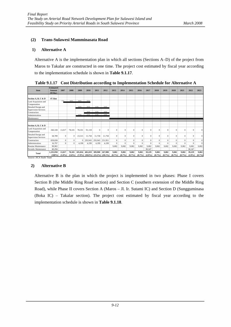
Final Report The Study on Arterial Road Network Development Plan for Sulawesi Island and Feasibility Study on Priority Arterial Roads in South Sulawesi Province March 2008
9-12
(2) Trans-Sulawesi Mamminasata Road
1) Alternative A
Alternative A is the implementation plan in which all sections (Sections A–D) of the project from Maros to Takalar are constructed in one time. The project cost estimated by fiscal year according to the implementation schedule is shown in Table 9.1.17.
Table 9.1.17 Cost Distribution according to Implementation Schedule for Alternative A Item
EstimatedAmount(M Rp.)
2007 2008 2009 2010 2011 2012 2013 2014 2015 2016 2017 2018 2019 2020 2021 2022 2023
Section A, B, C & D 47.1kmLand Acquisition andCompensation 260,338
5.0% 30.0% 30.0% 35.0%
Detailed Design andSupervision Services 58,789
40.0% 20.0% 20.0% 20.0%
Construction 839,838 35.0% 35.0% 30.0%
Administraition 16,797 25.0% 25.0% 25.0% 25.0%
Maintenance
Section A, B, C & DLand Acquisition andCompensation 260,338 13,017 78,101 78,101 91,118 0 0 0 0 0 0 0 0 0 0 0 0 0
Detailed Design andSupervision Services 58,789 0 0 23,515 11,758 11,758 11,758 0 0 0 0 0 0 0 0 0 0 0
Construction 839,838 0 0 0 293,943 293,943 251,951 0 0 0 0 0 0 0 0 0 0 0Administraition 16,797 0 0 4,199 4,199 4,199 4,199 0 0 0 0 0 0 0 0 0 0 0Routine Maintenance 99,902 9,082 9,082 9,082 9,082 9,082 9,082 9,082 9,082 9,082 9,082 9,082Periodic Maintenance 60,294 30,147 30,147
1,335,958 13,017 78,101 105,816 401,019 309,900 267,908 9,082 9,082 9,082 9,082 39,229 9,082 9,082 9,082 9,082 39,229 9,082(100%) (1.0%) (5.8%) (7.9%) (30.0%) (23.2%) (20.1%) (0.7%) (0.7%) (0.7%) (0.7%) (2.9%) (0.7%) (0.7%) (0.7%) (0.7%) (2.9%) (0.7%)
Source: JICA Study Team
Total
2) Alternative B
Alternative B is the plan in which the project is implemented in two phases: Phase I covers Section B (the Middle Ring Road section) and Section C (southern extension of the Middle Ring Road), while Phase II covers Section A (Maros – Jl. Ir. Sutami IC) and Section D (Sungguminasa (Boka IC) – Takalar section). The project cost estimated by fiscal year according to the implementation schedule is shown in Table 9.1.18.

Final Report The Study on Arterial Road Network Development Plan for Sulawesi Island and Feasibility Study on Priority Arterial Roads in South Sulawesi Province March 2008
9-13
Table 9.1.18 Cost Distribution according to Implementation Schedule for Alternative B
ItemEstimatedAmount(M Rp.)
2007 2008 2009 2010 2011 2012 2013 2014 2015 2016 2017 2018 2019 2020 2021 2022 2023
Phase ISection B & C 15.9kmLand Acquisition andCompensation 127,130
5.0% 30.0% 30.0% 35.0%
Detailed Design andSupervision Services 32,286
40.0% 20.0% 20.0% 20.0%
Construction 461,224 35.0% 35.0% 30.0%
Administraition 9,224 25.0% 25.0% 25.0% 25.0%
MaintenancePhase IISection A & D 31.2kmLand Acquisition andCompensation 133,208
25.0% 25.0% 25.0% 25.0%
Detailed Design andSupervision Services 26,503
8.0% 32.0% 20.0% 20.0% 20.0%
Construction 378,614 33.3% 33.3% 33.3%
Administraition 7,572 11.1% 22.2% 22.2% 22.2% 22.2%
Maintenance
Phase ISection B & CLand Acquisition andCompensation 127,130 6,357 38,139 38,139 44,496 0 0 0 0 0 0 0 0 0 0 0 0 0
Detailed Design andSupervision Services 32,286 0 0 12,914 6,457 6,457 6,457 0 0 0 0 0 0 0 0 0 0 0
Construction 461,224 0 0 0 161,428 161,428 138,367 0 0 0 0 0 0 0 0 0 0 0Administraition 9,224 0 0 2,306 2,306 2,306 2,306 0 0 0 0 0 0 0 0 0 0 0Routine Maintenance 29,506 2,682 2,682 2,682 2,682 2,682 2,682 2,682 2,682 2,682 2,682 2,682Periodic Maintenance 17,090 8,545 8,545
676,460 6,357 38,139 53,359 214,687 170,192 147,130 2,682 2,682 2,682 2,682 11,227 2,682 2,682 2,682 2,682 11,227 2,682(100%) (0.9%) (5.6%) (7.9%) (31.7%) (25.2%) (21.8%) (0.4%) (0.4%) (0.4%) (0.4%) (1.7%) (0.4%) (0.4%) (0.4%) (0.4%) (1.7%) (0.4%)
Phase IISection A & DLand Acquisition andCompensation 133,208 0 0 0 33,302 33,302 33,302 33,302 0 0 0 0 0 0 0 0 0 0
Detailed Design andSupervision Services 26,503 0 0 0 0 2,120 8,481 5,301 5,301 5,301 0 0 0 0 0 0 0 0
Construction 378,614 0 0 0 0 0 0 126,205 126,205 126,205 0 0 0 0 0 0 0 0Administraition 7,572 0 0 0 0 841 1,683 1,683 1,683 1,683 0 0 0 0 0 0 0 0Routine Maintenance 51,197 6,400 6,400 6,400 6,400 6,400 6,400 6,400 6,400Periodic Maintenance 21,602 21,602
618,696 0 0 0 33,302 36,264 43,466 166,490 133,188 133,188 6,400 6,400 6,400 6,400 28,002 6,400 6,400 6,400(100%) (0.0%) (0.0%) (0.0%) (5.4%) (5.9%) (7.0%) (26.9%) (21.5%) (21.5%) (1.0%) (1.0%) (1.0%) (1.0%) (4.5%) (1.0%) (1.0%) (1.0%)
1,295,157 6,357 38,139 53,359 247,989 206,455 190,596 169,172 135,870 135,870 9,082 17,627 9,082 9,082 30,684 9,082 17,627 9,082(100%) (0.5%) (2.9%) (4.1%) (19.1%) (15.9%) (14.7%) (13.1%) (10.5%) (10.5%) (0.7%) (1.4%) (0.7%) (0.7%) (2.4%) (0.7%) (1.4%) (0.7%)
Source: JICA Study Team
Total
Total
Grand Total
3) Alternative C
Alternative C is the plan in which Section B (the Middle Ring Road section) and Section C (southern extension of the Middle Ring Road) would be constructed as an express toll road with frontage roads along Section B in Phase I, while Section A (Maros – Jl. Ir. Sutami IC section) and Section D (Sungguminasa (Boka IC) – Takalar section) would be widened in Phase II. The project cost estimated by fiscal year according to the implementation schedule is shown in Table 9.1.19.

Final Report The Study on Arterial Road Network Development Plan for Sulawesi Island and Feasibility Study on Priority Arterial Roads in South Sulawesi Province March 2008
9-14
Table 9.1.19 Cost Distribution according to Implementation Schedule for Alternative C
ItemEstimatedAmount(M Rp.)
2007 2008 2009 2010 2011 2012 2013 2014 2015 2016 2017 2018 2019 2020 2021 2022 2023
Phase ISection B & C (Toll Road 15.9kmLand Acquisition andCompensation 127,130
5.0% 30.0% 30.0% 35.0%
Detailed Design andSupervision Services 35,514
40.0% 20.0% 20.0% 20.0%
Construction 507,346 35.0% 35.0% 30.0%
Administraition 10,147 25.0% 25.0% 25.0% 25.0%
MaintenanceSection B (Frontage Road 7.1kmLand Acquisition andCompensation 0
5.0% 30.0% 30.0% 35.0%
Detailed Design andSupervision Services 11,411
40.0% 20.0% 20.0% 20.0%
Construction 163,010 35.0% 35.0% 30.0%
Administraition 3,260 25.0% 25.0% 25.0% 25.0%
MaintenancePhase IISection A & D 31.2kmLand Acquisition andCompensation
133,208 25.0% 25.0% 25.0% 25.0%
Detailed Design andSupervision Services 26,503 8.0% 32.0% 20.0% 20.0% 20.0%
Construction 378,614 33.3% 33.3% 33.3%
Administraition 7,572 11.1% 22.2% 22.2% 22.2% 22.2%
Maintenance
Phase ISection B & C (Toll Road)Land Acquisition andCompensation 127,130 6,357 38,139 38,139 44,496 0 0 0 0 0 0 0 0 0 0 0 0 0
Detailed Design andSupervision Services 35,514 0 0 14,206 7,103 7,103 7,103 0 0 0 0 0 0 0 0 0 0 0
Construction 507,346 0 0 0 177,571 177,571 152,204 0 0 0 0 0 0 0 0 0 0 0Administraition 10,147 0 0 2,537 2,537 2,537 2,537 0 0 0 0 0 0 0 0 0 0 0Routine Maintenance 101,469 9,224 9,224 9,224 9,224 9,224 9,224 9,224 9,224 9,224 9,224 9,224Periodic Maintenance 55,347 27,673 27,673
836,954 6,357 38,139 54,881 231,706 187,211 161,843 9,224 9,224 9,224 9,224 36,898 9,224 9,224 9,224 9,224 36,898 9,224(100%) (0.8%) (4.6%) (6.6%) (27.7%) (22.4%) (19.3%) (1.1%) (1.1%) (1.1%) (1.1%) (4.4%) (1.1%) (1.1%) (1.1%) (1.1%) (4.4%) (1.1%)
Section B (Frontage Road)Land Acquisition andCompensation 0 0 0 0 0 0 0 0 0 0 0 0 0 0 0 0 0 0
Detailed Design andSupervision Services 11,411 0 0 4,564 2,282 2,282 2,282 0 0 0 0 0 0 0 0 0 0 0
Construction 163,010 0 0 0 57,054 57,054 48,903 0 0 0 0 0 0 0 0 0 0 0Administraition 3,260 0 0 815 815 815 815 0 0 0 0 0 0 0 0 0 0 0Routine Maintenance 16,301 1,482 1,482 1,482 1,482 1,482 1,482 1,482 1,482 1,482 1,482 1,482Periodic Maintenance 14,819 7,410 7,410
208,801 0 0 5,379 60,151 60,151 52,000 1,482 1,482 1,482 1,482 8,891 1,482 1,482 1,482 1,482 8,891 1,482(100%) (0.0%) (0.0%) (2.6%) (28.8%) (28.8%) (24.9%) (0.7%) (0.7%) (0.7%) (0.7%) (4.3%) (0.7%) (0.7%) (0.7%) (0.7%) (4.3%) (0.7%)
Phase IISection A & DLand Acquisition andCompensation 133,208 0 0 0 33,302 33,302 33,302 33,302 0 0 0 0 0 0 0 0 0 0
Detailed Design andSupervision Services 26,503 0 0 0 0 2,120 8,481 5,301 5,301 5,301 0 0 0 0 0 0 0 0
Construction 378,614 0 0 0 0 0 0 126,205 126,205 126,205 0 0 0 0 0 0 0 0Administraition 7,572 0 0 0 0 841 1,683 1,683 1,683 1,683 0 0 0 0 0 0 0 0Routine Maintenance 22,193 2,774 2,774 2,774 2,774 2,774 2,774 2,774 2,774Periodic Maintenance 13,870 13,870
581,961 0 0 0 33,302 36,264 43,466 166,490 133,188 133,188 2,774 2,774 2,774 2,774 16,645 2,774 2,774 2,774(100%) (0.0%) (0.0%) (0.0%) (5.7%) (6.2%) (7.5%) (28.6%) (22.9%) (22.9%) (0.5%) (0.5%) (0.5%) (0.5%) (2.9%) (0.5%) (0.5%) (0.5%)
1,627,716 6,357 38,139 60,261 325,159 283,625 257,309 177,196 143,894 143,894 13,480 48,563 13,480 13,480 27,351 13,480 48,563 13,480(100%) (0.4%) (2.3%) (3.7%) (20.0%) (17.4%) (15.8%) (10.9%) (8.8%) (8.8%) (0.8%) (3.0%) (0.8%) (0.8%) (1.7%) (0.8%) (3.0%) (0.8%)
Source: JICA Study Team
Total
Total
Grand Total
Total
Source: JICA Study Team estimation
(3) Hertasning Road
The project cost estimated by fiscal year according to the implementation schedule is shown in Table 9.1.20.

Final Report The Study on Arterial Road Network Development Plan for Sulawesi Island and Feasibility Study on Priority Arterial Roads in South Sulawesi Province March 2008
9-15
Table 9.1.20 Cost Distribution according to Implementation Schedule for Hertasning Road EstimatedAmount 2006 2007 2008 2009 2010 2011 2012 2013 2014 2015 2016 2017 2018 2019 2020 2021 2022 2023
(M. Rp.) 1 2 3 4 5 6 7 8 9 10 11 12 13 14 15 16 17
4.9 kmHertasning Road 4.9 kmLand Acquisition andCompensation 9,833 40% 50% 10%
Detailed Design andSupervision Services 4,269 10% 30% 30% 30%
Construction 60,989 30% 40% 30%
Administraition 1,220 25% 25% 25% 25%
Maintenance Routine 2,627 8% 8% 8% 8% 8% 8% 8% 8% 8% 8% 8% 8% 8%
Maintenance Overlay per 5Years 8,082 50% 50%
Hertasning RoadLand Acquisition andCompensation 9,833 3,933 4,917 983
Detailed Design andSupervision Services 4,269 427 1,281 1,281 1,281
Construction 60,989 18,297 24,396 18,297Administraition 1,220 305 305 305 305Maintenance Routine 2,627 202 202 202 202 202 202 202 202 202 202 202 202 202Maintenance Overlay per 5Years 8,082 4,041 4,041
87,019 3,933 5,648 20,866 25,981 19,882 202 202 202 202 4,243 202 202 202 202 4,243 202 202 202100% 4.5% 6.5% 24.0% 29.9% 22.8% 0.2% 0.2% 0.2% 0.2% 4.9% 0.2% 0.2% 0.2% 0.2% 4.9% 0.2% 0.2% 0.2%
3. Hertasning Road
Item
Total Source: JICA Study Team estimation
(4) Abdullah Daeng Sirua Road
The project cost estimated by fiscal year according to the implementation schedule is shown in Table 9.1.21.

Final Report The Study on Arterial Road Network Development Plan for Sulawesi Island and Feasibility Study on Priority Arterial Roads in South Sulawesi Province March 2008
9-16
Table 9.1.21 Cost Distribution according to Implementation Schedule for Abdullah Daeng Sirua Road
Amount 2006 2007 2008 2009 2010 2011 2012 2013 2014 2015 2016 2017 2018 2019 2020 2021 2022 2023(M. Rp.) 1 2 3 4 5 6 7 8 9 10 11 12 13 14 15 16 17
15.3 km
Makassar Section (West) 7.0 km
Land Acquisition and Compensa 31,451 50% 50%
Detailed Design and Supervision 6,386 33% 33% 33%
Construction 91,230 50% 50%
Administraition 1,825 25% 25% 25% 25%
Maintenance Routine 2,965 8% 8% 8% 8% 8% 8% 8% 8% 8% 8% 8% 8%
Maintenance Overlay per 5 Year 9,884 50% 50%
Makassar Section (West)
Land Acquisition and Compensa 31,451 15,725 15,725Detailed Design and Supervision 6,386 2,129 2,129 2,129Construction 91,230 45,615 45,615Administraition 1,825 456 456 456 456Maintenance Routine 2,965 247 247 247 247 247 247 247 247 247 247 247 247Maintenance Overlay per 5 Year 9,884 4,942 4,942
143,741 16,181 18,310 48,200 48,200 247 247 247 247 5,189 247 247 247 247 5,189 247 247100% 11.3% 12.7% 33.5% 33.5% 0.2% 0.2% 0.2% 0.2% 3.6% 0.2% 0.2% 0.2% 0.2% 3.6% 0.2% 0.2%
Maros/Gowa Section (East) 8.3 km
Land Acquisition and Compensa 5,424 20% 40% 40%
Detailed Design and Supervision 8,694 20% 20% 20% 20% 20%
Construction 124,199 25% 25% 25% 25%
Administraition 2,484 17% 17% 17% 17% 17% 17%
Maintenance Routine 2,785 13% 13% 13% 13% 13% 13% 13% 13%
Maintenance Overlay per 5 Year 6,963 100%
Maros/Gowa Section (East)
Land Acquisition and Compensa 5,424 1,085 2,170 2,170Detailed Design and Supervision 8,694 1,739 1,739 1,739 1,739 1,739Construction 124,199 31,050 31,050 31,050 31,050Administraition 2,484 414 414 414 414 414 414Maintenance Routine 2,785 348 348 348 348 348 348 348 348Maintenance Overlay per 5 Year 6,963 6,963
150,549 1,499 4,322 35,372 33,203 33,203 33,203 348 348 348 348 7,311 348 348 348100% 1.0% 2.9% 23.5% 22.1% 22.1% 22.1% 0.2% 0.2% 0.2% 0.2% 4.9% 0.2% 0.2% 0.2%
150,549 16,181 18,310 49,699 52,522 35,619 33,450 33,450 33,450 5,537 595 595 595 7,558 5,537 595 595100% 1.0% 2.9% 23.5% 22.1% 22.1% 22.1% 0.2% 0.2% 0.2% 0.2% 4.9% 0.2% 0.2% 0.2%
Sub-Total
Sub-Total
4. Abdullah Daeng Sirua Road
Total
Item
Source: JICA Study Team estimation
9.2 Economic Evaluation
9.2.1 Target Roads for Evaluation
The purpose of economic evaluation is to investigate whether the implementation of the selected roads is justified from the viewpoint of national economy, by comparing their economic benefits with economic costs. The target roads for evaluation are the following four (4) roads in the Mamminasata Metropolitan Area:
1) Road-1: Mamminasa Bypass (48.6 km)
2) Road-2: Trans-Sulawesi Mamminasata Road (47.3 km)
3) Road-3: Hertasning Road (4.9 km)
4) Road-4: Abdullah Daeng Sirua Road (14.6 km) In addition to the above four (4) roads, the Outer Ring Road and Tj.Bunga-Takalar Road were also evaluated and the results are presented in Appendix F and Appendix G respectively.
Final Report The Study on Arterial Road Network Development Plan for Sulawesi Island and Feasibility Study on Priority Arterial Roads in South Sulawesi Province March 2008
9-17
9.2.2 Evaluation Scenarios
(1) Implementation Schedule of Target Roads
The economic benefit of each target road is affected by its implementation timing (construction period and opening year) and the construction of other competitive road links as well. The overall implementation schedule for all road projects including the above target roads is proposed in Chapter 10 and traffic demand forecasts were carried out in Chapter 5 in accordance with that overall schedule. Therefore, economic evaluation of the target roads was made keeping consistency with the overall implementation schedule.
All the above target roads were evaluated as non-toll roads except for the Trans-Sulawesi Mamminasata Road for which alternative evaluation cases for both non-toll and toll expressway were examined as explained below.
(2) Evaluation of Alternatives for Trans-Sulawesi Mamminasata Road
Considering its importance and roles in the Mamminasata Metropolitan Area, the following three (3) evaluation scenarios were prepared for the Trans-Sulawesi Mamminasata Road.
Case 1: Non-toll (toll-free) road case (the Trans-Sulawesi Mamminasata Road is constructed as a toll-free road like an ordinary national road or city road). However, it is proposed to collect a low toll at the two bridges (Tallo River Bridge and Jeneberang River Bridge) in order to secure a fund source to cover the annual maintenance cost.
Sub-Case 1-1: Construction of all sections of the Trans-Sulawesi Mamminasata Road and their opening to public traffic at the beginning of 2013 simultaneously.
Sub-Case 1-2: Phase-wise construction (Phase 1: the Middle Ring Road and its access sections opening to public traffic in 2013, and Phase 2: the rest of the sections opening at the beginning of 2016).
Case 2: Toll road case (the Middle Ring Road Section and its access road are constructed as a full access-controlled toll road with frontage roads, opening to public traffic in 2013 and the rest of the sections opening at the beginnig of 2016).
Figure 9.2.1 illustrates the above scenarios to be examined for the Trans-Sulawesi Mamminasata Road.
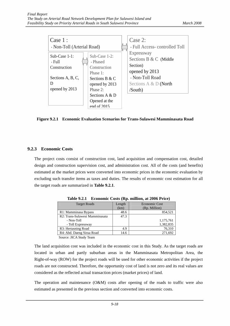
Final Report The Study on Arterial Road Network Development Plan for Sulawesi Island and Feasibility Study on Priority Arterial Roads in South Sulawesi Province March 2008
9-18
Case 1 :・Non-Toll (Arterial Road)
Sub-Case 1-1:・FullConstruction
Sections A, B, C,Dopened by 2013
Case 2:・Full Access- controlled TollExpresswaySections B & C (MiddleSection)opened by 2013・Non-Toll RoadSections A & D (North/South)
Sub-Case 1-2:・PhasedConstructionPhase 1:Sections B & Copened by 2013Phase 2:Sections A & DOpened at theend of 2015
Figure 9.2.1 Economic Evaluation Scenarios for Trans-Sulawesi Mamminasata Road
9.2.3 Economic Costs
The project costs consist of construction cost, land acquisition and compensation cost, detailed design and construction supervision cost, and administration cost. All of the costs (and benefits) estimated at the market prices were converted into economic prices in the economic evaluation by excluding such transfer items as taxes and duties. The results of economic cost estimation for all the target roads are summarized in Table 9.2.1.
Table 9.2.1 Economic Costs (Rp. million, at 2006 Price)
Target Roads Length(km)
Economic Cost (Rp. Million)
R1: Mamminasa Bypass 48.6 854,521 R2: Trans-Sulawesi Mamminasata
- Non-Toll - Toll Expressway
47.3 1,175,761 1,382,835
R3: Hertasning Road 4.9 76,310 R4: Abd. Daeng Sirua Road 14.6 271,692
Source: JICA Study Team
The land acquisition cost was included in the economic cost in this Study. As the target roads are located in urban and partly suburban areas in the Mamminasata Metropolitan Area, the Right-of-way (ROW) for the project roads will be used for other economic activities if the project roads are not constructed. Therefore, the opportunity cost of land is not zero and its real values are considered as the reflected actual transaction prices (market prices) of land.
The operation and maintenance (O&M) costs after opening of the roads to traffic were also estimated as presented in the previous section and converted into economic costs.
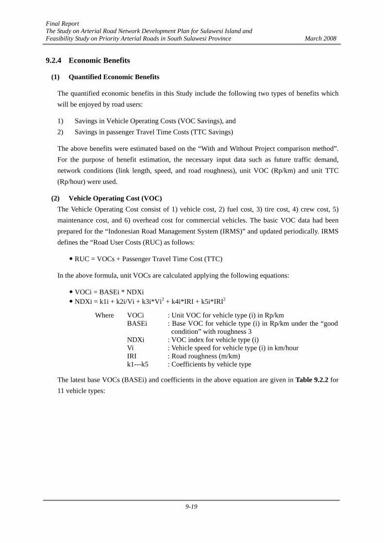
Final Report The Study on Arterial Road Network Development Plan for Sulawesi Island and Feasibility Study on Priority Arterial Roads in South Sulawesi Province March 2008
9-19
9.2.4 Economic Benefits
(1) Quantified Economic Benefits
The quantified economic benefits in this Study include the following two types of benefits which will be enjoyed by road users:
1) Savings in Vehicle Operating Costs (VOC Savings), and 2) Savings in passenger Travel Time Costs (TTC Savings)
The above benefits were estimated based on the “With and Without Project comparison method”. For the purpose of benefit estimation, the necessary input data such as future traffic demand, network conditions (link length, speed, and road roughness), unit VOC (Rp/km) and unit TTC (Rp/hour) were used.
(2) Vehicle Operating Cost (VOC) The Vehicle Operating Cost consist of 1) vehicle cost, 2) fuel cost, 3) tire cost, 4) crew cost, 5) maintenance cost, and 6) overhead cost for commercial vehicles. The basic VOC data had been prepared for the “Indonesian Road Management System (IRMS)” and updated periodically. IRMS defines the “Road User Costs (RUC) as follows:
RUC = VOCs + Passenger Travel Time Cost (TTC)
In the above formula, unit VOCs are calculated applying the following equations:
VOCi = BASEi * NDXi NDXi = k1i + k2i/Vi + k3i*Vi2 + k4i*IRI + k5i*IRI2
Where VOCi BASEi NDXi Vi IRI k1---k5
: Unit VOC for vehicle type (i) in Rp/km : Base VOC for vehicle type (i) in Rp/km under the “good
condition” with roughness 3 : VOC index for vehicle type (i) : Vehicle speed for vehicle type (i) in km/hour : Road roughness (m/km) : Coefficients by vehicle type
The latest base VOCs (BASEi) and coefficients in the above equation are given in Table 9.2.2 for 11 vehicle types:
Final Report The Study on Arterial Road Network Development Plan for Sulawesi Island and Feasibility Study on Priority Arterial Roads in South Sulawesi Province March 2008
9-20
Table 9.2.2 VOC Coefficients and Base VOC No. Vehicle Type K1 K2 K3 K4 K5 Base VOC
(Rp/km) 1 Sedan 0.66707 22.23983 0.000006808 0.012937 0.00139 1.396.10 2 Utility Passenger 0.57932 20.34176 0.000018379 0.014087 0.00093 1.186.77 3 Utility Freight 0.58382 20.30049 0.000018278 0.013313 0.00079 1,414.64 4 Light Bus 0.32475 21.93222 0.000028582 0.068937 -0.00007 1,724.67 5 Large Bus 0.32985 22.26215 0.000053281 0.012930 0.00069 2,735.78 6 Light Truck 0.42258 20.52269 0.000027740 0.044006 -0.00006 1,592.41 7 Medium Truck -0.17257 28.62223 0.000100534 0.061250 0.00016 2,444.33 8 Heavy Truck 0.11065 21.20004 0.000085612 0.044117 0.00041 3,481.37 9 Truck Trailer 0.29038 13.69068 0.000068153 0.053472 0.00027 5,447.68
10 Tractor Trailer 0.59807 10.02214 0.000021525 0.044723 0.00009 7,180.32 11 Motor cycle 1.05130 13.71763 -0.000009124 0.009024 0.00052 201.90
Source: IRMS: Updating the VOC Equation Coefficients, 2006
The above base data and coefficients were applied to this Study after checking and comparing the calculated unit VOC values with those of other recent studies. Figure 9.2.2 indicates the estimated VOC curves explained by travel speed in the case of road roughness 3.
Source: JICA Study Team (drawn from the data of IRMS)
Figure 9.2.2 VOC Curves by Vehicle Type (IRI=3)
(3) Passenger Travel Time Cost (TTC)
The savings in travel time cost are another important component of road users’ benefit. IRMS estimated the unit value of travel time (Rp/hour/vehicle) at 2006 price level based on the traditional “income approach method” as shown in Table 9.2.3. Factors which were taken into account for the calculation of unit TTC per vehicle for IRMS are:
1) Monthly income of passengers by vehicle group, 2) Shadow Wage Rate (=0.85), 3) Monthly working hours (=191 hours),
IRMS VOC
0.0
1000.0
2000.0
3000.0
4000.0
5000.0
6000.0
7000.0
8000.0
10 15 20 25 30 35 40 45 50 55 60 65 70 75 80
Speed (km/hour)
VO
C (R
p/km
)
Sedan M.Bus L.Bus Pickup Truck

Final Report The Study on Arterial Road Network Development Plan for Sulawesi Island and Feasibility Study on Priority Arterial Roads in South Sulawesi Province March 2008
9-21
4) Non-work time value (=28% of work time value), 5) Trip purpose percentage of work trips and non-work trips by vehicle group, and 6) Average occupancy (number of passengers per vehicle).
Table 9.2.3 Passenger Travel Time Cost (Rp/hour/vehicle: 2006) Passenger Monthly Income
VehicleType
Sedan Utility Passenger
Utility Freight
Light Bus
Large Bus
Truck
Motor- Cycle
Income/month (Rp) 2,640,000 836,000 748,000 836,000 836,000 748,000 1,056,000Income at SWR 2,244,000 710,600 635,800 710,600 710,600 635,800 897,600Working hours/month 191 191 191 191 191 191 191
Passenger TTC per Hour Work time value (Rp) 11,749 3,720 3,329 3,720 3,720 3,329 4,699Non-work time value 3,290 1,042 932 1,042 1,042 932 1,316% Work trips 50% 30% 75% 30% 30% 75% 50% % Non-work trips 50% 70% 25% 70% 70% 25% 50% Occupancy (persons) 2.0 8.0 1.0 16.0 32.0 1.0 1.2 TTC/passenger/hr 7,519 1,845 2,730 1,845 1,845 2,730 3,008TTC/vehicle/hr (Rp) 15,038 14,763 2,730 29,525 59,050 2,730 3,609
Source: IRMS: Updating the VOC Equation Coefficients, 2006
In order to confirm the applicability of the above estimated time value to this Study, a comparison with a past study (Heavy Loaded Road Improvement Project (HLIP) – Master Plan Review Study, December 2001) was made as shown in Table 9.2.4:
Table 9.2.4 Comparison of Time Values Time Value/hour/person) Time Value/hour/vehicle
Category HLIP 2001 (Sulawesi)*
IRMS 2006**
Vehicle Type HLIP 2001
(Sulawesi)* IRMS
2006** Car user, working Bus user, working Car user, non-working Bus user, non-working
9,7353,8092,9201,143
11,7493,7203,2901,042
Car Passenger Utility Medium Bus Large Bus
11,560 12,850 26,226 53,996
15,03814,76329,52559,050
Source: *: Heavy Loaded Road Improvement Project-II, Master Plan Review Study for National Network Roads, Final Report, Volume 2, December 2001.
**: IRMS: Updating the VOC Equation Coefficients, 2006.
Although the time values shown in Table 9.2.3 by IRMS (2006) seem to be not much higher than those of the HLIP Study considering a five-year span (2001 - 2006), it was judged that the time values in Table 9.2.3 are in the acceptable range and thus they were applied to this Study.
(4) Total Benefits Estimated
The road users’ costs (VOC and TTC) were calculated applying the above unit values (Rp/vehicle/km and Rp/vehicle/hour) to the results of traffic assignment simulations for the both “With Project” and “Without Project” cases. The economic benefit is defined as the difference of the total road users’ cost between “Without Project” and “With Project” cases. The results of benefit estimate are summarized in Table 9.2.5.
Final Report The Study on Arterial Road Network Development Plan for Sulawesi Island and Feasibility Study on Priority Arterial Roads in South Sulawesi Province March 2008
9-22
Table 9.2.5 Estimated Economic Benefits (Unit: Rp million)
Economic Benefit Target Roads Year VOC
Savings Passenger Travel
Time Savings
Total
2016 35,473
10,569
46,042
2020 54,027
17,939
71,966
R1: Mamminasa Bypass
2023 185,774
79,428
265,202
2013 360,515
142,759
503,274
2015 364,933
150,449
515,382
2020 375,979
169,673
545,652
R2: Trans-Sulawesi Mamminasata
(Non-toll) Simultaneous opens in 2013
2023 431,086
195,523
626,609
2013 144,206
57,104
201,310
2015 364,933
150,449
515,382
2020 375,979
169,673
545,652
R2: Trans-Sulawesi Mamminasata
(Non-toll) Phase-wise construction
2023 431,086
195,523
626,609
2013 144,565
57,721
202,287
2015 369,826
153,578
523,404
2020 390,859
176,764
567,623
R2: Trans-Sulawesi Mamminasata (Toll Expressway)
2023 452,647
206,180
658,827
2011 17,710
9,931
27,641
2015 36,272
8,833
45,105
2020 54,871
15,313
70,184
R3: Hertasning Road
2023 59,687
18,972
78,659
2012 43,765
20,509
64,274
2015 62,521
29,299
91,820
2020 30,056
23,512
53,568
R4: Abd. Daeng Sirua Road (*)
2023 29,142
27,321
56,463
Source: JICA Study Team Note: (*): Benefits of Abd. Daeng Sirua Road will be affected by introduction of a competitive new road link before 2020.

Final Report The Study on Arterial Road Network Development Plan for Sulawesi Island and Feasibility Study on Priority Arterial Roads in South Sulawesi Province March 2008
9-23
9.2.5 Economic Evaluation
(1) Premises for Evaluation For the purpose of economic evaluation, the following preconditions were established:
- Price level - Evaluation Period - Disbursement Schedule - Residual Value - Opportunity Cost of Capital
: Constant 2006 prices : 30 years after the first opening to traffic : Assumed in accordance with the construction plan : No residual values : 15% (and 12% for reference)
(2) Economic Cash Flows and Evaluation Indicators
The calculated cost and benefit cash flows are shown in Table 9.2.8 to Table 9.2.13. The following three kinds of evaluation indicators were calculated based on the conventional Discount Cash Flow method (DCF):
1) Economic Internal Rate of Return (EIRR) 2) Net Present Value (NPV) 3) Benefit/ Cost Ratio (B/C)
The results of evaluation are summarized in Table 9.2.6. :
Table 9.2.6 Results of Economic Evaluation Evaluation Indicators Target Roads
EIRR NPV (Rp. million) (*) B/C (*) R1: Mamminasa Bypass 22.4% 171,550 1.97 R2: Trans-Sulawesi Mamminasata Road -(Non-Toll) 2013 simultaneous open -(Non-Toll) Phasing -(Toll Expressway)
28.5% 30.2% 26.7%
768,273 721,063 648,842
2.30 2.45 2.07
R3: Hertasning Road 33.8% 122,258 3.51 R4: Abd. Daeng Sirua Road 31.0% 110,466 1.96
Source: JICA Study Team (*) Discount Rate = 15%
The above results show that the implementation of all the target roads is economically feasible with values of EIRR sufficiently higher than the opportunity cost of capital (> 15%), positive figures of NPV (> 0), and higher B/C ratios than unity (> 1). Among all the target roads, the Trans-Sulawesi Mamminasata Road (non-toll and phasing construction case), Abd. Daeng Sirua Road and Hertasning Road have a higher EIRR of 30.7%, 31.0% and 33.8% respectively. NPV for the Trans-Sulawesi Mamminasata Road is the highest among the F/S roads.
(3) Sensitivity Analysis
1) Prepared Cases for Sensitivity Tests
The robustness of feasibility of the Project was tested by changing the related factors within a probable range. The test cases prepared in this sensitivity analysis are as follows:

Final Report The Study on Arterial Road Network Development Plan for Sulawesi Island and Feasibility Study on Priority Arterial Roads in South Sulawesi Province March 2008
9-24
Test 1: Project Cost: 10% up, Project Benefit: 10% down Test 2: Project Cost 20% up, Project Benefit: 20% down Test 3: Evaluation Period: 20 years after opening
2) Results of Sensitivity Analysis
The results of the three tests for each target road are summarized in Table 9.2.7.
Table 9.2.7 Sensitivity Analysis Target Roads Tested Cases EIRR
(%) NPV (*)
(Rp.Million) B/C (*)
R1:Mamminasa Bypass
Original Case Test 1: cost 10% up, benefit 10 % down Test 2: cost 20% up, benefit 20% down Test 3: evaluation period: 20 years
22.4 20.0 17.8 21.3
171,550 119,192 66,835 112,193
1.97 1.62 1.32 1.64
Sub-Case 1-1 : (Non-toll, Simultaneous open) Original Case Test 1: cost 10% up, benefit 10 % down Test 2: cost 20% up, benefit 20% down Test 3: evaluation period: 20 years
28.5 24.7 21.2 28.4
768,273 573,342 378,412 697,599
2.30 1.88 1.53 2.18
Sub-Case 1-2 : (Non-toll, Phased construction) Original Case Test 1: cost 10% up, benefit 10 % down Test 2: cost 20% up, benefit 20% down Test 3: evaluation period: 20 years
30.2 26.2 22.5 30.1
721,063 549,738 378,413 650,842
2.45 2.01 1.64 2.32
Case 2 : Toll Road Case
R2: Trans-Sulawesi Mamminasata
Original Case Test 1: cost 10% up, benefit 10 % down Test 2: cost 20% up, benefit 20% down Test 3: evaluation period: 20 years
26.7 23.0 19.6 26.5
648,842 462,164 275,487 575,360
2.07 1.69 1.38 1.95
R3: Hertasning Road Original Case Test 1: cost 10% up, benefit 10 % down Test 2: cost 20% up, benefit 20% down Test 3: evaluation period: 20 years
33.8 30.0 26.4 33.7
122,258 100,279 78,300 107,936
3.51 2.87 2.34 3.22
R4: Abd. Daeng Sirua Road
Original Case Test 1: cost 10% up, benefit 10 % down Test 2: cost 20% up, benefit 20% down Test 3: evaluation period: 20 years
31.0 25.5 20.5 30.9
110,466 76,357 42,248 102,522
1.96 1.60 1.31 1.89
Source: JICA Study Team (*) Discount Rate = 15%
The above results indicate the robustness of the economic feasibility of all the target roads showing that the values of EIRR are higher than 15%, figures of NPV are positive (NPV > 0), and B/C ratios are higher than unity (B/C > 1) in any of the cases prepared for the sensitivity analysis.
9.2.6 Conclusions of Economic Evaluation
(1) High Economic Return and Recommended Construction Schedule
The results of economic evaluation justify the viability of all the target roads to be constructed in accordance with the proposed overall implementation schedule. The Trans-Sulawesi Mamminasata Road (non-toll case), Abd. Daeng Sirua Road and Hertasning Road (and other target roads as well) show quite high economic returns with values of EIRR higher than the opportunity cost of capital (15.0%), and the implementation of all the target roads is justified from the viewpoint of national economy. In addition, the target roads will contribute to sustainable economic growth of the
Final Report The Study on Arterial Road Network Development Plan for Sulawesi Island and Feasibility Study on Priority Arterial Roads in South Sulawesi Province March 2008
9-25
Mamminasata Metropolitan Area by supporting regional development plans in various sectors. Regarding the Trans-Sulawesi Mamminasata Road, it is recommended to be implemented as a non-toll arterial road (not as a toll expressway) because the economic return in the non-toll road case is higher than that in the toll expressway case.
(2) Ensuring Maintenance Cost after Opening
Maintenance after opening of the target roads is very important for maintaining the project roads in good condition. Therefore, it is recommended to collect a low toll fee from road users for the purpose of securing the annual and periodic maintenance cost. In this Study, it is assumed to collect users’ charge at the toll gates provided at the two new bridges along the Trans-Sulawesi Mamminasata Road (Tallo River Bridge and Jeneberang Bridge) at a rate of one-third of that applied at the existing Ir. Sutami Toll Road.

Final Report The Study on Arterial Road Network Development Plan for Sulawesi Island and Feasibility Study on Priority Arterial Roads in South Sulawesi Province March 2008
9-26
Table 9.2.8 Cost Benefit Cash Flow (R1: Mamminasa Bypass) (Rp. million)
Source: JICA Study Team
Balance
2006 0 0 02007 0 0 02008 0 0 02009 0 0 02010 0 0 02011 10,701 10,701 0 -10,7012012 25,181 25,181 0 -25,1812013 109,159 109,159 0 -109,1592014 120,580 120,580 0 -120,5802015 96,578 96,578 0 -96,578
1 2016 50,659 314 50,973 46,042 -4,9312 2017 48,923 314 49,236 52,523 3,2873 2018 7,338 519 7,857 59,004 51,1474 2019 60,697 519 61,216 65,485 4,2695 2020 61,604 6,790 68,394 71,966 3,5726 2021 88,731 519 89,251 136,378 47,1277 2022 91,706 4,631 96,337 200,790 104,4538 2023 82,664 519 83,183 265,202 182,0199 2024 2,019 2,019 297,408 295,389
10 2025 8,290 8,290 329,614 321,32411 2026 2,019 2,019 361,820 359,80112 2027 6,131 6,131 394,026 387,89513 2028 32,017 32,017 426,232 394,21514 2029 2,019 2,019 458,438 456,41915 2030 8,290 8,290 490,644 482,35416 2031 2,019 2,019 522,850 520,83117 2032 6,131 6,131 555,056 548,92518 2033 32,017 32,017 587,262 555,24519 2034 2,019 2,019 619,468 617,44920 2035 8,290 8,290 651,674 643,38421 2036 2,019 2,019 683,880 681,86122 2037 6,131 6,131 716,086 709,95523 2038 32,017 32,017 748,292 716,27524 2039 2,019 2,019 780,498 778,47925 2040 8,290 8,290 812,704 804,41426 2041 2,019 2,019 844,910 842,89127 2042 6,131 6,131 877,116 870,98528 2043 32,017 32,017 909,322 877,30529 2044 2,019 2,019 941,528 939,50930 2045 8,290 8,290 973,734 965,444
854,521 226,338 1,080,859 14,879,952 13,799,093
22.4%NPV Discount Rate 15% 171,550
(Rp million) Discount Rate 12% 414,057Discount Rate 15% 1.97Discount Rate 12% 2.74
Project Cost(incl.LA)
SQ No. Year
EIRR
B/C
B-C
Cost (C)Benefit (B)O & M Total Cost

Final Report The Study on Arterial Road Network Development Plan for Sulawesi Island and Feasibility Study on Priority Arterial Roads in South Sulawesi Province March 2008
9-27
Table 9.2.9 Cost Benefit Cash Flow (R2: Trans-Sulawesi Mamminasata Road: Case 1-1:Non-Toll)
(Rp. million) Source: JICA Study Team
BalanceSQ Year Construction VOC TCC
& Land Aquistion Routin Periodic Savings Savings B-C2006 0 0 0 0 0 0 02007 13,017 0 13,017 0 0 0 -13,0172008 78,101 0 78,101 0 0 0 -78,1012009 105,816 0 105,816 0 0 0 -105,8162010 401,019 0 401,019 0 0 0 -401,0192011 309,900 0 309,900 0 0 0 -309,9002012 267,908 0 267,908 0 0 0 -267,908
1 2013 9,082 9,082 360,515 142,759 503,274 494,1922 2014 9,082 9,082 362,724 146,604 509,328 500,2463 2015 9,082 9,082 364,933 150,449 515,382 506,3004 2016 9,082 9,082 367,142 154,294 521,436 512,3545 2017 9,082 30,147 39,229 369,351 158,139 527,490 488,2616 2018 9,082 9,082 371,561 161,983 533,544 524,4627 2019 9,082 9,082 373,770 165,828 539,598 530,5168 2020 9,082 9,082 375,979 169,673 545,652 536,5709 2021 9,082 9,082 394,348 178,290 572,638 563,55610 2022 9,082 30,147 39,229 412,717 186,906 599,623 560,39411 2023 9,082 9,082 431,086 195,523 626,609 617,52712 2024 9,082 9,082 431,086 195,523 626,609 617,52713 2025 9,082 9,082 431,086 195,523 626,609 617,52714 2026 9,082 9,082 431,086 195,523 626,609 617,52715 2027 9,082 30,147 39,229 431,086 195,523 626,609 587,38016 2028 9,082 9,082 431,086 195,523 626,609 617,52717 2029 9,082 9,082 431,086 195,523 626,609 617,52718 2030 9,082 9,082 431,086 195,523 626,609 617,52719 2031 9,082 9,082 431,086 195,523 626,609 617,52720 2032 9,082 86,420 95,502 431,086 195,523 626,609 531,10721 2033 9,082 9,082 431,086 195,523 626,609 617,52722 2034 9,082 9,082 431,086 195,523 626,609 617,52723 2035 9,082 9,082 431,086 195,523 626,609 617,52724 2036 9,082 9,082 431,086 195,523 626,609 617,52725 2037 9,082 30,147 39,229 431,086 195,523 626,609 587,38026 2038 9,082 9,082 431,086 195,523 626,609 617,52727 2039 9,082 9,082 431,086 195,523 626,609 617,52728 2040 9,082 9,082 431,086 195,523 626,609 617,52729 2041 9,082 9,082 431,086 195,523 626,609 617,52730 2042 9,082 30,147 39,229 431,086 195,523 626,609 587,380
1,175,761 272,460 237,155 1,685,376 12,374,759 5,525,386 17,900,145 16,214,769
28.5%NPV 768,273
(Rp million) 1,340,9792.302.94
B/C Discount Rate: 15%Discount Rate: 12%
Discount Rate: 12%
Benefit (B)O & M Total
Benefit
Cost (C)TotalCost
Discount Rate: 15%EIRR
Final Report The Study on Arterial Road Network Development Plan for Sulawesi Island and Feasibility Study on Priority Arterial Roads in South Sulawesi Province March 2008
9-28
Table 9.2.10 Cost Benefit Cash Flow (R2: Trans-Sulawesi Mamminasata Road, Case 1-2: Non-Toll: Phasing)
(Rp. million)
BalanceYear VOC TCC
Savings Savings B-CPhase 1 Phase 2 Phase 1 Phase 2 Phase 1 Phase 2
2006 0 0 0 0 0 0 0 02007 6,357 0 0 6,357 0 0 0 -6,3572008 38,139 0 0 38,139 0 0 0 -38,1392009 53,359 0 0 53,359 0 0 0 -53,3592010 214,687 33,302 0 247,989 0 0 0 -247,9892011 170,192 36,264 0 206,456 0 0 0 -206,456
Phase 1 2012 147,130 43,466 0 190,596 0 0 0 -190,5961 2013 166,490 2,682 169,172 144,206 57,104 201,310 32,1382 Phase 2 2014 133,188 2,682 135,870 254,569 103,776 358,346 222,4763 2015 133,188 2,682 135,870 364,933 150,449 515,382 379,5124 1 2016 2,682 6,400 9,082 367,142 154,294 521,436 512,3545 2 2017 2,682 6,400 8,545 17,627 369,351 158,139 527,490 509,8636 3 2018 2,682 6,400 9,082 371,561 161,983 533,544 524,4627 4 2019 2,682 6,400 9,082 373,770 165,828 539,598 530,5168 5 2020 2,682 6,400 21,602 30,684 375,979 169,673 545,652 514,9689 6 2021 2,682 6,400 9,082 394,348 178,290 572,638 563,55610 7 2022 2,682 6,400 8,545 17,627 412,717 186,906 599,623 581,99611 8 2023 2,682 6,400 9,082 431,086 195,523 626,609 617,52712 9 2024 2,682 6,400 9,082 431,086 195,523 626,609 617,52713 10 2025 2,682 6,400 21,602 30,684 431,086 195,523 626,609 595,92514 11 2026 2,682 6,400 9,082 431,086 195,523 626,609 617,52715 12 2027 2,682 6,400 8,545 17,627 431,086 195,523 626,609 608,98216 13 2028 2,682 6,400 9,082 431,086 195,523 626,609 617,52717 14 2029 2,682 6,400 9,082 431,086 195,523 626,609 617,52718 15 2030 2,682 6,400 21,602 30,684 431,086 195,523 626,609 595,92519 16 2031 2,682 6,400 9,082 431,086 195,523 626,609 617,52720 17 2032 2,682 6,400 42,714 51,796 431,086 195,523 626,609 574,81321 18 2033 2,682 6,400 9,082 431,086 195,523 626,609 617,52722 19 2034 2,682 6,400 9,082 431,086 195,523 626,609 617,52723 20 2035 2,682 6,400 43,705 52,787 431,086 195,523 626,609 573,82224 21 2036 2,682 6,400 9,082 431,086 195,523 626,609 617,52725 22 2037 2,682 6,400 8,545 17,627 431,086 195,523 626,609 608,98226 23 2038 2,682 6,400 9,082 431,086 195,523 626,609 617,52727 24 2039 2,682 6,400 9,082 431,086 195,523 626,609 617,52728 25 2040 2,682 6,400 21,602 30,684 431,086 195,523 626,609 595,92529 26 2041 2,682 6,400 9,082 431,086 195,523 626,609 617,52730 27 2042 2,682 6,400 8,545 17,627 431,086 195,523 626,609 608,982
629,864 545,898 80,460 172,800 85,439 130,113 1,644,574 12,050,296 5,396,902 17,447,198 15,802,624
30.2%NPV 721,063
(Rp million) 1,258,7802.453.11
Discount Rate: 12%
B/C Discount Rate: 15%Discount Rate: 12%
Discount Rate: 15%
Cost (C)
Routine PeriodicO & MLand Acquisition &
Construction
EIRR1,175,762
SQBenefit (B)
TotalBenefit
TotalCost
Source: JICA Study Team

Final Report The Study on Arterial Road Network Development Plan for Sulawesi Island and Feasibility Study on Priority Arterial Roads in South Sulawesi Province March 2008
9-29
Table 9.2.11 Cost Benefit Cash Flow (R2: Trans-Sulawesi Mamminasata Road, Case 2: Toll Expressway)
(Rp. million)
BalanceSQ Year VOC TCC
Toll & Frontage Other sections Routin 1 Routin 2 Periodic 1 Periodic 2 Savings Savings B-C2006 0 0 0 0 0 0 0 02007 6,357 0 0 6,357 0 0 0 -6,3572008 38,139 0 0 38,139 0 0 0 -38,1392009 60,260 0 0 60,260 0 0 0 -60,2602010 291,857 27,286 0 319,143 0 0 0 -319,1432011 247,362 31,309 0 278,671 0 0 0 -278,671
Phase 1 2012 213,843 38,511 0 252,354 0 0 0 -252,3541 Phase 2 2013 161,535 10,706 172,241 144,565 57,721 202,287 30,0462 2014 133,188 10,706 143,894 257,196 105,650 362,845 218,9513 2015 133,188 10,706 143,894 369,826 153,578 523,404 379,5104 1 2016 10,706 2,774 13,480 374,033 158,215 532,248 518,7685 2 2017 10,706 2,774 35,083 48,563 378,239 162,852 541,092 492,5296 3 2018 10,706 2,774 13,480 382,446 167,490 549,935 536,4557 4 2019 10,706 2,774 13,480 386,652 172,127 558,779 545,2998 5 2020 10,706 2,774 13,870 27,350 390,859 176,764 567,623 540,2739 6 2021 10,706 2,774 13,480 411,455 186,569 598,024 584,544
10 7 2022 10,706 2,774 35,083 48,563 432,051 196,375 628,426 579,86311 8 2023 10,706 2,774 13,480 452,647 206,180 658,827 645,34712 9 2024 10,706 2,774 13,480 452,647 206,180 658,827 645,34713 10 2025 10,706 2,774 13,870 27,350 452,647 206,180 658,827 631,47714 11 2026 10,706 2,774 13,480 452,647 206,180 658,827 645,34715 12 2027 10,706 2,774 35,083 48,563 452,647 206,180 658,827 610,26416 13 2028 10,706 2,774 13,480 452,647 206,180 658,827 645,34717 14 2029 10,706 2,774 13,480 452,647 206,180 658,827 645,34718 15 2030 10,706 2,774 13,870 27,350 452,647 206,180 658,827 631,47719 16 2031 10,706 2,774 13,480 452,647 206,180 658,827 645,34720 17 2032 10,706 2,774 35,083 48,563 452,647 206,180 658,827 610,26421 18 2033 10,706 2,774 13,480 452,647 206,180 658,827 645,34722 19 2034 10,706 2,774 13,480 452,647 206,180 658,827 645,34723 20 2035 10,706 2,774 13,870 27,350 452,647 206,180 658,827 631,47724 21 2036 10,706 2,774 13,480 452,647 206,180 658,827 645,34725 22 2037 10,706 2,774 35,083 48,563 452,647 206,180 658,827 610,26426 23 2038 10,706 2,774 13,480 452,647 206,180 658,827 645,34727 24 2039 10,706 2,774 13,480 452,647 206,180 658,827 645,34728 25 2040 10,706 2,774 13,870 27,350 452,647 206,180 658,827 631,47729 26 2041 10,706 2,774 13,480 452,647 206,180 658,827 645,34730 27 2042 10,706 2,774 35,083 48,563 452,647 206,180 658,827 610,264
857,818 525,017 321,180 74,898 210,498 69,350 2,058,761 12,580,262 5,660,941 18,241,203 16,182,442
26.7%NPV 648,842
(Rp million) 1,188,0062.072.62
1,382,835
EIRR
B/C Discount Rate: 15%Discount Rate: 12%
Discount Rate: 12%Discount Rate: 15%
Cost (C)O & M
Benefit (B)Total
BenefitTotalCost
Construction & L.A. cost
Source: JICA Study Team

Final Report The Study on Arterial Road Network Development Plan for Sulawesi Island and Feasibility Study on Priority Arterial Roads in South Sulawesi Province March 2008
9-30
Table 9.2.12 Cost Benefit Cash Flow (R3: Hertasning Road)
(Rp. million)
Source: JICA Study Team
Balance
2006 3,933 3,933 0 -3,9332007 5,648 5,648 0 -5,6482008 20,866 20,866 0 -20,8662009 25,981 25,981 0 -25,9812010 19,882 19,882 0 -19,882
1 2011 202 202 27,641 27,4392 2012 202 202 32,007 31,8053 2013 202 202 36,373 36,1714 2014 202 202 40,739 40,5375 2015 4,243 4,243 45,105 40,8626 2016 202 202 50,121 49,9197 2017 202 202 55,137 54,9358 2018 202 202 60,152 59,9509 2019 202 202 65,168 64,966
10 2020 4,243 4,243 70,184 65,94111 2021 202 202 73,009 72,80712 2022 202 202 75,834 75,63213 2023 202 202 78,659 78,45714 2024 202 202 80,072 79,86915 2025 4,243 4,243 81,484 77,24116 2026 202 202 82,897 82,69417 2027 202 202 84,309 84,10718 2028 202 202 85,722 85,51919 2029 202 202 87,134 86,93220 2030 4,243 4,243 88,547 84,30421 2031 202 202 89,959 89,75722 2032 202 202 91,372 91,16923 2033 202 202 92,784 92,58224 2034 202 202 94,197 93,99425 2035 4,243 4,243 95,609 91,36626 2036 202 202 97,022 96,81927 2037 202 202 98,434 98,23228 2038 202 202 99,847 99,64429 2039 202 202 101,259 101,05730 2040 4,243 4,243 102,672 98,429
76,310 30,307 106,617 2,263,445 2,156,828
33.8%NPV Discount Rate 15% 122,258
(Rp million) Discount Rate 12% 200,823Discount Rate 15% 3.51Discount Rate 12% 4.69
B-CYearCost (C)
Benefit (B)Project Cost(incl.LA) Total CostO & MSQ No.
EIRR
B/C

Final Report The Study on Arterial Road Network Development Plan for Sulawesi Island and Feasibility Study on Priority Arterial Roads in South Sulawesi Province March 2008
9-31
Table 9.2.13 Cost Benefit Cash Flow (R4: Abdullah Daeng Sirua Road)
(Rp. million)
Source: JICA Study Team
Balance
2006 0 0 02007 0 0 02008 16,181 16,181 0 -16,1812009 18,310 18,310 0 -18,3102010 49,699 49,699 0 -49,6992011 52,522 52,522 0 -52,522
1 2012 35,372 247 35,619 64,274 28,6552 2013 33,203 247 33,450 73,456 40,0063 2014 33,203 247 33,450 82,638 49,1884 2015 33,203 247 33,450 91,820 58,3705 2016 5,537 5,537 101,002 95,4656 2017 595 595 110,184 109,5897 2018 595 595 119,366 118,7718 2019 595 595 128,548 127,9539 2020 7,558 7,558 53,568 46,010
10 2021 5,537 5,537 54,533 48,99611 2022 595 595 55,498 54,90312 2023 595 595 56,463 55,86813 2024 595 595 56,946 56,35114 2025 7,558 7,558 57,428 49,87015 2026 5,537 5,537 57,911 52,37416 2027 595 595 58,393 57,79817 2028 595 595 58,876 58,28118 2029 595 595 59,358 58,76319 2030 7,558 7,558 59,841 52,28320 2031 5,537 5,537 60,323 54,78621 2032 595 595 60,806 60,21122 2033 595 595 61,288 60,69323 2034 595 595 61,771 61,17624 2035 7,558 7,558 62,253 54,69525 2036 5,537 5,537 62,736 57,19926 2037 595 595 63,218 62,62327 2038 595 595 63,701 63,10628 2039 595 595 64,183 63,58829 2040 7,558 7,558 64,666 57,10830 2041 5,537 5,537 65,148 59,611
271,693 80,925 352,618 2,090,192 1,737,574
31.0%NPV Discount Rate 15% 110,466
(Rp million) Discount Rate 12% 181,568Discount Rate 15% 1.96Discount Rate 12% 2.32
EIRR
B/C
SQ No. B-CYearCost (C)
Benefit (B)Project Cost(incl.LA) Total CostO & M

Final Report The Study on Arterial Road Network Development Plan for Sulawesi Island and Feasibility Study on Priority Arterial Roads in South Sulawesi Province March 2008
9-32
9.3 Financial Evaluation
9.3.1 Purpose of Analysis
It is recommended, based on the results of economic evaluation, to implement the Trans-Sulawesi Mamminasata Road as a non-toll road from the viewpoint of national economy.
Bina Marga conducted a freeway/toll road study for Sulawesi Island in 2006. The study recommended to implement the Trans-Sulawesi Mamminasata Middle Section as a PPP project. Therefore, its financial viability was reviewed in addition to the above economic evaluation and recommendations. An additional analysis was carried out to determine whether the Project Road should be implemented as a full access-controlled toll expressway with participation of the private sector such form as BOT (Build-Operate-Transfer) or PPP (Public-Private Partnership). The purpose of the analysis was to evaluate the financial viability of the toll road and effects on the Government’s financial burden.
9.3.2 Target Toll Road Sections for Financial Evaluation
In this Study, the analysis was carried out assuming that the toll road system (fully access-controlled with ramps/interchanges to collect toll fares and keeping higher serviceability) will be introduced for the sections of the Middle Ring and its southern access roads (total length = 15.8 km as indicted in Figure 9.3.1). Therefore, the project costs (construction cost and operation and maintenance cost) to be compared with the toll revenues are limited to the costs of this toll road section (not all the costs of the whole Trans-Sulawesi Mamminasata Section).
Sungguminasa
B
C
Jl.Perin
tis
Middle Ring R
oad
Jeneberang River
New JeneberangRiver Bridge (392m)
New Tallo RiverBridge (136m)
Boka
L=8.6kmToll Only
L=7.3km(Toll +Frontage)
Full Access-controlledTollExpresswayto be studiedfor PPPviability
Figure 9.3.1 Target Road Sections for Fully Access-controlled Toll Road
9.3.3 Analytical Framework

Final Report The Study on Arterial Road Network Development Plan for Sulawesi Island and Feasibility Study on Priority Arterial Roads in South Sulawesi Province March 2008
9-33
Financial analysis is, in general, carried out for the projects which generate revenue/income. The purpose of financial analysis is to investigate the financial viability of a project by comparing the revenues with the costs in terms of market prices (financial costs).
The first step of the evaluation is to calculate the Financial Internal Rate of Return (FIRR) from the side of a Special Purpose Company (SPC) which is responsible for preparing its own fund, constructing and operating the toll road.
The second step is to judge to which category the project toll road will belong, referring to its financial viability (value of FIRR). According to the government regulation, the basic concept of toll road investment classifies the toll road business into the following three categories (refer to “Toll Road in Indonesia” of Indonesian Toll Road Authority):
1) If a toll road is economically feasible, but not financially viable, it is financed by the Government. This is the case of conventional public investment.
2) If a toll road is economically feasible and financially viable, it can be financed by a business entity (private sector). This is the case of BOT (Build-Operate-Transfer).
3) If a toll road is economically feasible, but marginally viable, it can be co-financed by both the Government and business entities. This is the case of PPP (Public-Private Partnership) scheme.
The minimum FIRR value required for a project to be financially viable and acceptable or attractive for private sector participation is generally considered to be in a range of 16% - 20%. However, in actual situations, a FIRR of 16% is not sufficient to attract private sector participation due to many kinds of risk of toll road business. Therefore, the threshold value of FIRR is set at 20% in this Study.
The third step of the evaluation is that if the project toll road falls into the category 3) above, analysis is focused on how much the Government should be involved in financing the toll road in various ways such as subsidies to initial investment, “shadow toll” to cover the shortage of toll revenues, and service payments in order to achieve the minimum FIRR requirement of 20%.
9.3.4 Financial Return on Investment
(1) Assumptions for Calculation of FIRR
The following assumptions were set to calculate FIRR for the first step:
Toll Rate: The initial toll rates by vehicle type were decided to be at the same level of the existing Ir Sutami Toll Road considering the route length as shown below:

Final Report The Study on Arterial Road Network Development Plan for Sulawesi Island and Feasibility Study on Priority Arterial Roads in South Sulawesi Province March 2008
9-34
Vehicle Type Tariff 1. Sedan 2. Mini Bus 3. Large Bus 4. Pickup 5. Truck
Rp. 1500 Rp. 1500 Rp. 2500 Rp. 2500 Rp. 3000
Revision of Toll Rates: The toll rates were adjusted every two years based on the inflation index (8.6% per annum, an average of Makassar City, 2002- April 2007, BPS).
Evaluation Period: 30 years after opening.
Traffic Volume on Toll Road: Future traffic demand on the project toll road was forecast in Chapter 5 of this Report.
(2) Financial Viability
Based on the above assumptions, FIRR was calculated as shown in Table 9.3.1. The value of FIRR of this toll road was estimated at 6.5% without any subsidies or other financial support by the Government.
In general, the toll road project with such a low financial return should be implemented under the conventional public investment scheme (toll road category 1 as explained above).
However, considering the financial situation of the Government, the next step of the analysis is to investigate how much the government subsidy to the private sector (SPC) for initial investment is required to recover the financial return (up to a FIRR of 20%).
9.3.5 Requirement of Government Subsidy
As shown in Table 9.3.2, in order to achieve the FIRR value of 20%, the Government should subsidy SPC with an amount equal to about 66.5% of the total construction cost (Rp. 405,270 million) and 72.0% (Rp. 523,078 million) of the total investment cost including the land acquisition cost. Although the Government’s financial burden will be reduced by about 28% (Value for Money: VFM) compared to the conventional public investment, the necessary expenditure by the Government is still huge.
There is no clear standard for PPP schemes to decide the financial sharing between the Government and the private sector in Indonesia at present.

Final Report The Study on Arterial Road Network Development Plan for Sulawesi Island and Feasibility Study on Priority Arterial Roads in South Sulawesi Province March 2008
9-35
Table 9.3.1 Financial Cash Flow (No Government Subsidy)
Construction O & M Toll GOI subsidy2007 0 0 0 0 02008 9,563 0 0 0 -9,5632009 181,133 0 0 0 -181,1332010 178,742 0 0 0 -178,7422011 178,742 0 0 0 -178,7422012 60,909 5,881 6,570 -60,2202013 12,115 16,993 4,8782014 12,479 18,488 6,0092015 12,853 23,568 10,7142016 13,239 25,331 12,0922017 54,545 31,954 -22,5912018 14,045 34,033 19,9882019 14,466 42,591 28,1252020 14,900 45,043 30,1432021 15,347 52,839 37,4922022 63,233 52,555 -10,6782023 16,282 61,647 45,3652024 16,770 61,311 44,5402025 17,274 73,047 55,7732026 17,792 73,784 55,9922027 73,304 88,212 14,9082028 18,875 89,404 70,5292029 19,442 106,849 87,4072030 20,025 108,255 88,2302031 20,626 129,333 108,7082032 84,980 130,992 46,0122033 21,882 156,447 134,5652034 22,538 158,402 135,8642035 23,214 189,126 165,9112036 23,911 191,432 167,5212037 98,515 228,494 129,9802038 25,367 231,215 205,8482039 26,128 275,902 249,7742040 26,912 279,110 252,1982041 27,719 332,965 305,2462042 114,205 336,749 222,544
FIRR 6.5%
COSTYear REVENUES R-C
Source JICA Study Team

Final Report The Study on Arterial Road Network Development Plan for Sulawesi Island and Feasibility Study on Priority Arterial Roads in South Sulawesi Province March 2008
9-36
Table 9.3.2 Financial Cash Flow (With Government Subsidy) GOI Subsidy
Construction O & M Toll GOI subsidy 66.5%2007 0 0 0 0 0 (Rp. Million)2008 9,563 0 0 202,635 193,072 405,2702009 181,133 0 0 202,635 21,5022010 178,742 0 0 0 -178,7422011 178,742 0 0 0 -178,7422012 60,909 5,881 6,570 -60,2202013 12,115 16,993 4,8782014 12,479 18,488 6,0092015 12,853 23,568 10,7142016 13,239 25,331 12,0922017 54,545 31,954 -22,5912018 14,045 34,033 19,9882019 14,466 42,591 28,1252020 14,900 45,043 30,1432021 15,347 52,839 37,4922022 63,233 52,555 -10,6782023 16,282 61,647 45,3652024 16,770 61,311 44,5402025 17,274 73,047 55,7732026 17,792 73,784 55,9922027 73,304 88,212 14,9082028 18,875 89,404 70,5292029 19,442 106,849 87,4072030 20,025 108,255 88,2302031 20,626 129,333 108,7082032 84,980 130,992 46,0122033 21,882 156,447 134,5652034 22,538 158,402 135,8642035 23,214 189,126 165,9112036 23,911 191,432 167,5212037 98,515 228,494 129,9802038 25,367 231,215 205,8482039 26,128 275,902 249,7742040 26,912 279,110 252,1982041 27,719 332,965 305,2462042 114,205 336,749 222,544
FIRR 20.00%
COSTYear REVENUES R-C
Source: JICA Study Team

Final Report The Study on Arterial Road Network Development Plan for Sulawesi Island and Feasibility Study on Priority Arterial Roads in South Sulawesi Province March 2008
9-37
9.3.6 Comparison of Government Burden
The Government’s financial burden for the project implementation changes depending on the road type (toll or non-toll) and implementation scheme (public investment or PPP). Cost comparison was made for each case as shown below:
Table 9.3.3 Comparison of Government Burden (Rp. Million)
Toll Road Construction
Non-toll Road
Difference
Public Investment 1 726,116 3 670,815 1-3 55,301 PPP Scheme 2 523,078 -
Saving 1-2 203,038 2 < 3
Source: JICA Study Team
The above comparison indicates that the Government’s burden will be reduced by Rp 203,038 million if the toll road construction is implemented under the PPP scheme. On the other hand, if the same road section is constructed as a non-toll road, the cost is Rp 55,301 million lower than the cost of its construction as a toll road by public investment. However, a comparison between a toll road under PPP and a non-toll road by public investment shows that the Government’s burden under the PPP scheme (Rp.523,078 million) is still lower than the non-toll road under traditional public investment (Rp.670,815 million) even if the total cost of a toll road is higher than that of a non-toll road.
It is noted, however, that decision on toll or non-toll, PPP or public investment should be given not only based on the simple cost comparison but also in a more comprehensive framework including the results of economic analysis.
9.3.7 Conclusions of Financial Evaluation
The financial evaluation indicates that the financial return of the Project as a toll road is very low with a FIRR of 6.5%. In general, the toll road project with such a low return is recommended to be implemented by public investment. In order to achieve the FIRR requirement of 20% to attract private sector participation, the Government should provide an upfront subsidy of more than 70 % of the total cost. This percentage of government subsidy is too high compared with the normal PPP schemes. The project is recommended to be implemented with public financing.
Good Marginal BadEIRR>18% 12% - 18% EIRR< 12%
Good FIRR>20% BOT* BOT* -Marginal 10%-20% PPP** PPP** -
Bad FIRR<10% PublicFinance
PublicFinance -
Note: As FIRR of the project was estimated at 6.5%, it is categorized into Public Finance.
Economic Feasibility
FinancialViability
Figure 9.3.2 Conclusion of Financial Evaluation
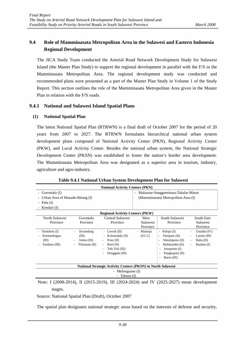
Final Report The Study on Arterial Road Network Development Plan for Sulawesi Island and Feasibility Study on Priority Arterial Roads in South Sulawesi Province March 2008
9-38
9.4 Role of Mamminasata Metropolitan Area in the Sulawesi and Eastern Indonesia Regional Development
The JICA Study Team conducted the Arterial Road Network Development Study for Sulawesi Island (the Master Plan Study) to support the regional development in parallel with the F/S in the Mamminasata Metropolitan Area. The regional development study was conducted and recommended plans were presented as a part of the Master Plan Study in Volume 1 of the Study Report. This section outlines the role of the Mamminasata Metropolitan Area given in the Master Plan in relation with the F/S roads.
9.4.1 National and Sulawesi Island Spatial Plans
(1) National Spatial Plan
The latest National Spatial Plan (RTRWN) is a final draft of October 2007 for the period of 20 years from 2007 to 2027. The RTRWN formulates hierarchical national urban system development plans composed of National Activity Center (PKN), Regional Activity Center (PKW), and Local Activity Center. Besides the national urban system, the National Strategic Development Center (PKSN) was established to foster the nation’s border area development. The Mamminasata Metropolitan Area was designated as a superior area in tourism, industry, agriculture and agro-industry.
Table 9.4.1 National Urban System Development Plan for Sulawesi
Note: I (2008-2014), II (2015-2019), III (2024-2024) and IV (2025-2027) mean development stages.
Source: National Spatial Plan (Draft), October 2007
The spatial plan designates national strategic areas based on the interests of defense and security,
National Activity Centers (PKN) - Gorontalo (I) - Urban Area of Manado-Bitung (I) - Palu (I) - Kendari (I)
- Makassar-Sungguminasa-Takalar-Maros (Mamminasata) Metropolitan Area (I)
Regional Activity Centers (PKW) North Sulawesi
Province Gorontalo Province
Central Sulawesi Province
West Sulawesi Province
South Sulawesi Province
South East Sulawesi Province
- Tomohon (I) - Kotamobagau (III) - Tondano (III)
- Kwandang (III)
- Isimu (III) - Tiilamuta (II)
- Luwuk (II) - Kolonodale (II)
- Poso (II) - Buol (II) - Toli-Toli (III) - Donggala (III)
- Mamuju (I/C/1)
- Palopo (I) - Parepare (II) - Watampone (II) - Bulukumba (II) - Jeneponto (I) - Pangkajene (II) - Barru (III)
- Unaaha (IV) - Lasolo (III) - Raha (II) - Baubau (I)
National Strategic Activity Centers (PKSN) in North Sulawesi - Melonguane (I)
- Tahuna (I)
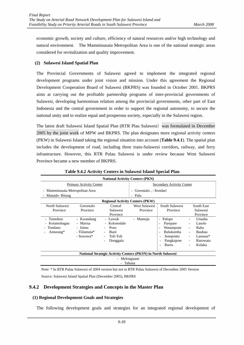
Final Report The Study on Arterial Road Network Development Plan for Sulawesi Island and Feasibility Study on Priority Arterial Roads in South Sulawesi Province March 2008
9-39
economic growth, society and culture, efficiency of natural resources and/or high technology and natural environment. The Mamminasata Metropolitan Area is one of the national strategic areas considered for revitalization and quality improvement.
(2) Sulawesi Island Spatial Plan
The Provincial Governments of Sulawesi agreed to implement the integrated regional development programs under joint vision and mission. Under this agreement the Regional Development Cooperation Board of Sulawesi (BKPRS) was founded in October 2001. BKPRS aims at carrying out the profitable partnership programs of inter-provincial governments of Sulawesi, developing harmonious relation among the provincial governments, other part of East Indonesia and the central government in order to support the regional autonomy, to secure the national unity and to realize equal and prosperous society, especially in the Sulawesi region.
The latest draft Sulawesi Island Spatial Plan (RTR Plau Sulawesi)was formulated in December 2005 by the joint work of MPW and BKPRS. The plan designates more regional activity centers (PKW) in Sulawesi Island taking the regional situation into account (Table 9.4.1). The spatial plan includes the development of road, including three trans-Sulawesi corridors, railway, and ferry infrastructure. However, this RTR Pulau Sulawesi is under review because West Sulawesi Province became a new member of BKPRS.
Table 9.4.2 Activity Centers in Sulawesi Island Special Plan
Note: * In RTR Pulau Sulawesi of 2004 version but not in RTR Pulau Sulawesi of December 2005 Version
Source: Sulawesi Island Spatial Plan (December 2005), BKPRS
9.4.2 Development Strategies and Concepts in the Master Plan
(1) Regional Development Goals and Strategies
The following development goals and strategies for an integrated regional development of
National Activity Centers (PKN) Primary Activity Center Secondary Activity Center
- Mamminasata Metropolitan Area - Manado- Bitung
- Gorontalo , - Kendari - Palu
Regional Activity Centers (PKW) North Sulawesi
Province Gorontalo Province
Central Sulawesi Province
West Sulawesi Province
South Sulawesi Province
South East Sulawesi Province
- Tomohon - Kotamobagau
- Tondano - Amurang*
- Kwandang - Marisa - Isimu - Tiilamuta* - Suwawa*
- Luwuk - Kolonodale
- Poso - Buol - Toli-Toli - Donggala
- Mamuju
- Palopo - Parepare - Watampone - Bulukumba - Jeneponto - Pangkajene - Barru
- Unaaha - Lasolo - Raha - Baubau - Lasusua* - Rarowatu - Kolaka
National Strategic Activity Centers (PKSN) in North Sulawesi - Melonguane
- Tahuna
Final Report The Study on Arterial Road Network Development Plan for Sulawesi Island and Feasibility Study on Priority Arterial Roads in South Sulawesi Province March 2008
9-40
Sulawesi Island were formulated.
Goal 1: Economic development through industrialization on the basis of ample natural resources from the agriculture, mining, and fishery sectors.
Goal 2: Island integration through social service improvement and the mitigation of economic gaps in the undeveloped rural areas.
To attain the development goals, the following regional development strategies are proposed:
Strategy 1: Economic growth through industrial development
To promote the economic growth of Sulawesi, industrial development, especially local processing industries utilizing agriculture, forest, fishery, and mining resources, is necessary.
Strategy 2- Effective economic growth on the basis of existing economic linkage
The existing economic linkage between six provinces of Sulawesi should be sufficiently utilized for the effective economic growth of Sulawesi. The economic linkage between priority service centers will benefit the rural areas, effectively alleviating poverty there.
Strategy 3: Social service improvement and mitigation of regional gaps through regional integration
Social service improvement and narrowing of regional gaps should be realized through regional integration and equitable provision of social services throughout the island.
Strategy 4: Development with due consideration of environmental preservation and disaster mitigation
For local farmers to benefit from the fruits of economic growth gained through strategies 1 and 2, training in modern agricultural technologies, methods and livelihood improvement is necessary.
(2) Sulawesi Island Development Concept
1) Industrial Development Concept
To help attaining the goals of economic growth through industrial development as indicated in Regional Development Strategy 1, four industrial development plans are proposed, as shown in Figure 9.4.1. These were based on the results of an analysis of development needs, development potentials, and global economic circumstances.

Final Report The Study on Arterial Road Network Development Plan for Sulawesi Island and Feasibility Study on Priority Arterial Roads in South Sulawesi Province March 2008
9-41
Development Potential•Existence of Resources (Agriculture, Mining,Fishery)•Existence of developed urban and industrial coreswith enough population for development
Global economy trend: demandincrease and value appreciation ofenergy, natural resources
Industrial Development Plan1) Expansion of resource based industry2) Promotion of inter-island linkages3) Expansion and development of existing/new Industrial/ trade cores4)Development of environment related industry and eco-tourism
Industrial Development Needs•Promotion of industrial development•Industrial development in priority areas andbenefiting to rural area in poverty•Needs for conservation of naturalenvironment (deforestation & fossil energyconsumption related to global warming issue)
Figure 9.4.1 Industrial Development Plan for Sulawesi
Prospective Resource-based Industries in Sulawesi
Several resource-based industries have great potential for development based on their production potential, global market trends, and domestic market linkages. New market tactics are important in order to realize the development of these prospective industries. To open up markets, especially China, some strategic measures should be taken under the framework of the ASEAN-China Free Trade Agreement (FTA). For instance, the export of cacao butter and powder processed in Sulawesi could find new markets if the imposed VAT is modified to benefit locally processed cacao. Moreover, the better treatment of FDI (foreign direct investment)/DDI (domestic direct investment) should also be tactically studied.
Promotion of Inter-island Linkages
The national spatial plan defines three transport corridors throghout Indonesia. These are the Northern, Middle and Southern corridors, as shown in Figure 9.4.2. Sulawesi occupies a strategic location that could link the three corridors including the neighboring ASEAN countries and even the northeastern Asian countries.
Another vital aspect of Sulawesi’s role in the national development is that it is located near the energy- resource-rich Kalimantan and Papua, as shown in Figure 9.4.3.

Final Report The Study on Arterial Road Network Development Plan for Sulawesi Island and Feasibility Study on Priority Arterial Roads in South Sulawesi Province March 2008
9-42
Northern Belt
Middle Belt
Southern Belt
Sulawesi
Cross BoarderTransport to Mindanao
Source: JICA Study Team
Figure 9.4.2 Proposed Linkage of Development Belts in Sulawesi
SulawesiKalimantan
Papua
Resource Supply Center ofFood, MaterialsEnergy Center of Oil, NaturalGas Production
Resourceof Food,
Materials,Manpower
Support
Support
Source: JICA Study Team
Figure 9.4.3 Sulawesi’s Role in Energy Resource Development in Eastern Indonesia
Development of Industrialized Centers
To promote industrial development, industrial centers should be enhanced in a manner that the investment environment for FDI and DDI is improved. Considering the availability and distribution of resources and the establishment of existing industries, the concept of industrialized centers is proposed as shown in Figure 9.4.4.
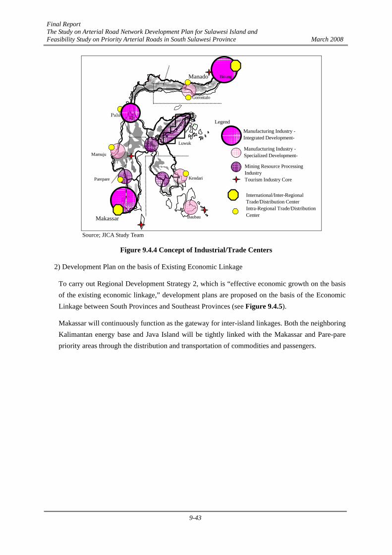
Final Report The Study on Arterial Road Network Development Plan for Sulawesi Island and Feasibility Study on Priority Arterial Roads in South Sulawesi Province March 2008
9-43
Mining Resource ProcessingIndustryTourism Industry Core
International/Inter-RegionalTrade/Distribution CenterIntra-Regional Trade/DistributionCenter
Manufacturing Industry -Integrated Development-
Manufacturing Industry -Specialized Development-
Legend
Gorontalo
Palu
Kendari
Makassar
BitungManado
Baubau
Mamuju
Luwuk
Parepare
Source; JICA Study Team
Figure 9.4.4 Concept of Industrial/Trade Centers
2) Development Plan on the basis of Existing Economic Linkage
To carry out Regional Development Strategy 2, which is “effective economic growth on the basis of the existing economic linkage,” development plans are proposed on the basis of the Economic Linkage between South Provinces and Southeast Provinces (see Figure 9.4.5).
Makassar will continuously function as the gateway for inter-island linkages. Both the neighboring Kalimantan energy base and Java Island will be tightly linked with the Makassar and Pare-pare priority areas through the distribution and transportation of commodities and passengers.

Final Report The Study on Arterial Road Network Development Plan for Sulawesi Island and Feasibility Study on Priority Arterial Roads in South Sulawesi Province March 2008
9-44
Kendari/Kolaka/Buton (Bukari) Integrated Economic Development Areas (KAPET) will be further developed as a mineral resources industrial center for nickel and asphalt. Agricultural (cashew nut, palm oil, cacao) and fishery, as well as wood processing industries will have great potentials for growth. Eco-tourism activities, on the other hand, can be promoted in the remote islands of Wakatobi and Selayar Island, as shown in Figure 9.4.5.
3) Social Service Improvement and Alleviation of Economic Gaps
In order to implement the Regional Development Strategy 3 on “social service improvement and alleviation of regional gaps by regional integration,” the following linkage plan between areas was conceived:
In line with population increases, the population concentration in the two developed cores of Makassar and Manado will accelerate, thereby requiring that the two developed cores be further developed to cope with such increases. At the same time, each provincial capital should function as the social and economic center of the respective province.
9.5 Logistic Support to promote Trade and Investment
(1) Present Situation
Within the Mamminasata Metropolitan Area, freight traffic is concentrated at present in the Makassar Industrial Estate (PT Kawasan Industri Makassar – KIMA). KIMA is located in the suburbs of Makassar City along the Ir. Sutami Toll road, 15 km north of the Makassar Port and around 10 minutes drive from the Hasanuddin International Airport. The existing area of KIMA is 203 hectares, and it is planned to be expanded to 703 hectares. The potentiality to provide more industrial estates is high in this area. Most of the KIMA area is currently occupied by agro-industrial business and other area by warehouses. There is no significant presence of manufacturing industries.
Reserved forestAgricultural
CementNickelAsphaltOil Refinery
BDFFishery and Marine Product ProcessingCocoaMeat Processing (Livestock) and AnimalFeedLight Industry (wood process such asplywood, furniture, garment, shoes, etc.)Other Food Manufacture (Coffee, Cashew,Vegetable, Sugar, Palm oil, Vanilla, etc.)Tourism
Consolidated FoodProcessing Center
Mamminsata
Kendari
ParePareKolaka
International/Inter-RegionalTrade/Distribution CenterIntra-RegionalTrade/Distribution Center
Wakatobi
BanataengSelayar Island
Baubau
Source: JST
Figure 9.4.5 Development Plan on the basis of Economic Linkage between Makassar-Kendari

Final Report The Study on Arterial Road Network Development Plan for Sulawesi Island and Feasibility Study on Priority Arterial Roads in South Sulawesi Province March 2008
9-45
(2) Development Plan for the Makassar Port
The cargo throughput of the Makassar Port in 2006 was around 7 million tons, of which the international cargo throughput accounted for around 33%.
Table 9.5.1 Cargo Throughput of the Makassar Port in 2006 (Unit: million tons)
Type Unloaded Loaded Total International Cargo 0.75 1.57 2.32 Domestic Cargo 3.43 1.34 4.77 Total 4.18 2.91 7.09
The PELINDO that is operating and managing the Makassar Port projected that by year 2015 the volume of containers to be handled by the Port would exceed the present handling capacity of 350,000 TEU per year of its container terminal . In order to cope with such situation, it was planned to build a new container terminal off-shore of the present berth, with a capacity of 500,000 TEU to meet the cargo demand in 2030 (refer to Figure 2.4.16 in Section 2.4).
Table 9.5.1 shows the present cargo throughput of the Makassar Port in 2006.
The volume of containers handled in the Makassar Port in 2006 was around 65,000 TEU. Assuming the average cargo load per TEU is 10 tons, it can be estimated at around 650,000 tons in weight. This accounts for just around 9% of the total cargo throughput of the Port.
Table 9.5.2 presents the projected cargo throughput in the Makassar Port in 2020 and 2030. The cargo throughput is projected to constantly increase at 2% per year and the containerization will reach 60% of the total cargo traffic.
Table 9.5.2 Projection of Cargo Throughput of the Makassar Port Year Total Cargo Throughput Container Cargo General Cargo 2020 9.36 million tons 560,000 TEU 3.7 million tons 2030 11.40 million tons 680,000 TEU 4.6 million tons
Source: JICA Study Team
(3) Hasanuddin Airport
The construction work of the new passenger terminal and taxiways has been progressing as scheduled and they are expected to be completed by the end of 2007. The Hasanuddin Airport is functioning as a hub-port for Eastern Indonesia. Though international flights are limited at present, it is anticipated that they will increase in the future in view of the progress of BIMP-EAGA and other international relations.
(4) Prospect of Industrialization in Mamminasata Metropolitan Area
The main stay of South Sulawesi’s economy is agriculture and the major commodities exported both to the international and regional destinations through the Makassar Port are agricultural
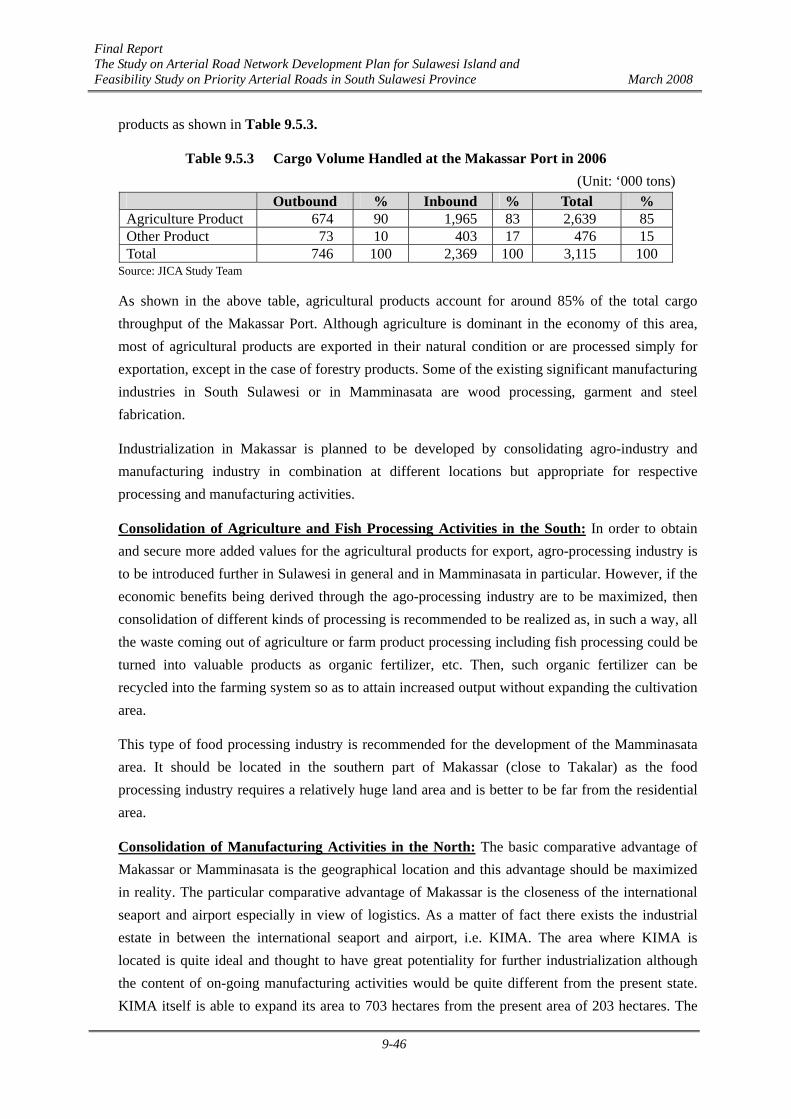
Final Report The Study on Arterial Road Network Development Plan for Sulawesi Island and Feasibility Study on Priority Arterial Roads in South Sulawesi Province March 2008
9-46
products as shown in Table 9.5.3.
Table 9.5.3 Cargo Volume Handled at the Makassar Port in 2006 (Unit: ‘000 tons)
Outbound % Inbound % Total % Agriculture Product 674 90 1,965 83 2,639 85 Other Product 73 10 403 17 476 15 Total 746 100 2,369 100 3,115 100
Source: JICA Study Team
As shown in the above table, agricultural products account for around 85% of the total cargo throughput of the Makassar Port. Although agriculture is dominant in the economy of this area, most of agricultural products are exported in their natural condition or are processed simply for exportation, except in the case of forestry products. Some of the existing significant manufacturing industries in South Sulawesi or in Mamminasata are wood processing, garment and steel fabrication.
Industrialization in Makassar is planned to be developed by consolidating agro-industry and manufacturing industry in combination at different locations but appropriate for respective processing and manufacturing activities.
Consolidation of Agriculture and Fish Processing Activities in the South: In order to obtain and secure more added values for the agricultural products for export, agro-processing industry is to be introduced further in Sulawesi in general and in Mamminasata in particular. However, if the economic benefits being derived through the ago-processing industry are to be maximized, then consolidation of different kinds of processing is recommended to be realized as, in such a way, all the waste coming out of agriculture or farm product processing including fish processing could be turned into valuable products as organic fertilizer, etc. Then, such organic fertilizer can be recycled into the farming system so as to attain increased output without expanding the cultivation area.
This type of food processing industry is recommended for the development of the Mamminasata area. It should be located in the southern part of Makassar (close to Takalar) as the food processing industry requires a relatively huge land area and is better to be far from the residential area.
Consolidation of Manufacturing Activities in the North: The basic comparative advantage of Makassar or Mamminasata is the geographical location and this advantage should be maximized in reality. The particular comparative advantage of Makassar is the closeness of the international seaport and airport especially in view of logistics. As a matter of fact there exists the industrial estate in between the international seaport and airport, i.e. KIMA. The area where KIMA is located is quite ideal and thought to have great potentiality for further industrialization although the content of on-going manufacturing activities would be quite different from the present state. KIMA itself is able to expand its area to 703 hectares from the present area of 203 hectares. The
Final Report The Study on Arterial Road Network Development Plan for Sulawesi Island and Feasibility Study on Priority Arterial Roads in South Sulawesi Province March 2008
9-47
area available for manufacturing activities, however in between the international seaport and airport, is vast and would possibly accommodate hundreds of manufacturers subject to the preparation of various infrastructures, not only physical infrastructure but also managerial infrastructure, that attract foreign and local investors to come in this area aiming at manufacturing competitive products.
(5) Projected Cargo Volume and Flow of Major Cargo
The northern zone would be occupied by manufacturing enterprises: It is assumed that the total area of industrial estate in the northern part of Makassar is 1,400 hectares. Assuming that one manufacturer would operate in this industrial estate and produce its products in an area of 4 hectares and the container transport requirement by one manufacturer per month is 40 TEU for transportation of raw materials and finished products, the annual cargo volume generated would be 168,000 TEU.
The outhern zone has high potentiality for agro-processing enterprises. It is assumed that around 20% of raw materials collected in this zone will be processed into the final products for distribution both in Sulawesi and out of Sulawesi. Table 9.5.4 shows the projected cargo volume of processed agricultural products for distribution and export. The cargo volume concentrated in these two different types of industrial zones is projected as shown in Table 9.5.5.
Table 9.5.4 Projection of Cargo Volume of Processed Agricultural Products Year Inter-provincial Intra-provincial Total Southern
Zone in Tons
Southern Zone in
TEU 2005 800 1,000 1,800 360 36 2020 4,000 4,900 8,900 1,780 178
Source: JICA Study Team
Table 9.5.5 Projection of Cargo Volume at Northern Part and Southern Part of Makassar (2020)
Projected Cargo Volume
In TEU per Year
Remarks
Northern Zone 1,680,000 tons
168,000 Area: 1,600 hectares
Southern Zone 1,780,000 tons
178,000 Livestock, fish preserved, animal feed, etc.
Total 3,400,000 tons
346,000
Source: JICA Study Team
(6) Inducing Trade and Investment
The comparative advantage of Sulawesi in general and Makassar in particular lies on their geographical location. However, this comparative advantage has not been realized as seen in

Final Report The Study on Arterial Road Network Development Plan for Sulawesi Island and Feasibility Study on Priority Arterial Roads in South Sulawesi Province March 2008
9-48
business as well as in investment, especially in the international market and foreign direct investment. This means that Makassar does not realize this comparative advantage that appeals to the international market and international investors. If and when the following conditions are met then the foreign capital and market will flow into Makassar.
1) Transport infrastructure combined with road, seaport and airport in an integrated way is available.
2) Other infrastructures such as power supply, water supply, wastewater treatment, telecommunication, etc. are provided in complete set for at least one modern industrial estate in between the international seaport and airport.
3) Containerization proceeds at a certain degree or more than 40% of goods produced and exported can be containerized.
4) Cost of logistics comprising container handling charge, trucking cost, agent fee, etc. is lowered to a competitive level against not only other major cities in Indonesia but also in other major cities in ASEAN countries.
5) At least one shuttle feeder service flying between Singapore and Makassar per week is realized by shipping companies.
6) At least one international flight between Singapore and other cities in Asia is available.
7) Regulation that attracts foreign direct investment is established.
8) Organized promotional activity is conducted for the introduction of foreign direct investment.
The development of the F/S roads would enhance industrial development in Sulawesi South Province and in the Mamminasata Metropolitan Area in particular. The Trans-Sulawesi Mamminasata Road will function as a major land transport infrastructure for sourcing and collection of raw materials for manufacturing and processing of various kinds of industrial products at a closest and proper location to the international seaport and airport, from north and south raw material production areas.
To realize industrialization as planned for Mamminasata, which would push up the economy of Sulawesi South as a whole, a large and constant flow of investment both from local and foreign countries is required. The potential investors who would consider Mamminasata as an interesting and safe destination for their investment would be attracted if and when the land and infrastructure which ensure the best function of logistic services for them have been prepared and put in the proper place in time. On the contrary if such needed infrastructure is lacking or does not exist, no investors will willingly invest into the industrial activities in Southern Sulawesi in general and in Mamminasata Region in particular.