chapter b2: residential subdivision
TRANSCRIPT

Wollongong Development Control Plan 2009 i
Contents
1 INTRODUCTION .................................................................................................................................................................................................. 1
2 OBJECTIVES ....................................................................................................................................................................................................... 1
3 DEFINITIONS ...................................................................................................................................................................................................... 2
4 TYPES OF RESIDENTIAL SUBDIVISION ............................................................................................................................................................ 2 4.1 Torrens Title Subdivision ....................................................................................................................................................................................... 2 4.2 Strata Title Subdivision ......................................................................................................................................................................................... 2 4.3 Community Title Subdivision .................................................................................................................................................................................. 3
5 TOPOGRAPHY, LANDFORM CONSERVATION, CUT AND FILL ......................................................................................................................... 4
6 SUBDIVISION DESIGN ........................................................................................................................................................................................ 6 6.1 Lot layout – Aspect and solar access ..................................................................................................................................................................... 7 6.2 Lot size ................................................................................................................................................................................................................. 7 6.3 Lot width and depth .............................................................................................................................................................................................. 8 6.4 Battle-axe lots ....................................................................................................................................................................................................... 9 6.5 Building envelopes ............................................................................................................................................................................................... 10 6.6 Superlots in residential subdivisions for integrated housing or medium density housing ......................................................................................... 11 6.7 Existing easements .............................................................................................................................................................................................. 11
7 MAJOR RESIDENTIAL SUBDIVISIONS ........................................................................................................................................................... 12
8 PUBLIC RESERVES AND OPEN SPACE ........................................................................................................................................................... 12
9 PEDESTRIAN AND BICYCLE NETWORKS ....................................................................................................................................................... 13
10 ACOUSTIC ASSESSMENT .............................................................................................................................................................................. 14
11 STREET TREE PLANTING ................................................................................................................................................................................ 14
12 ENTRY STATEMENTS ..................................................................................................................................................................................... 14
13 TRAFFIC FACILITIES ....................................................................................................................................................................................... 15
Part B – Land Use Based Planning Controls
Chapter B2: Residential Subdivision

ii Wollongong Development Control Plan 2009
Part B – Land Use Based Planning Controls Chapter B2: Residential Subdivision
13.1 Road connectivity, permeability and legibility ....................................................................................................................................................... 15 13.2 Road hierarchy and design requirements .............................................................................................................................................................. 16 13.3 Road and drainage construction ........................................................................................................................................................................... 33 13.4 Upgrading poorly constructed or unformed roads ................................................................................................................................................. 33 13.5 Half-road construction ......................................................................................................................................................................................... 33 13.6 Bus Routes and public transport .......................................................................................................................................................................... 33 13.7 Cul-de-sacs and turning heads ............................................................................................................................................................................. 34 13.8 Roundabouts and road junctions .......................................................................................................................................................................... 35 13.9 Traffic control measures ..................................................................................................................................................................................... 35 13.10 Splay corners ........................................................................................................................................................................................................ 36 13.11 Street lighting and fire hydrants ............................................................................................................................................................................... 37 13.12 Restricted access to collector or arterial roads .................................................................................................................................................... 37
14 BUSHFIRE PROTECTION ................................................................................................................................................................................. 39
15 STORMWATER DRAINAGE ............................................................................................................................................................................. 39
16 RIPARIAN LAND MANAGEMENT .................................................................................................................................................................... 40
17 SERVICING ARRANGEMENTS ......................................................................................................................................................................... 41
18 ROAD ADDRESSING ........................................................................................................................................................................................ 41
19 SUBDIVISION HANDOVER .............................................................................................................................................................................. 42

Part B – Land Use Based Planning Controls Chapter B2: Residential Subdivision
Wollongong Development Control Plan 2009 iii
Figures
Figure 1. Solar Access Orientation – Minimum Building Envelopes and Lot Widths .................... 8
Tables Table 1. Minimum allotment sizes ................................................................................................ 7 Table 2. Size and Location Criteria for Public Open Space ........................................................ 13 Table 3. Road network environments ......................................................................................... 18 Table 4. Carriageways and verges ............................................................................................. 19 Table 5. Street vegetation ........................................................................................................... 20


Part B – Land Use Based Planning Controls Chapter B2: Residential Subdivision
Wollongong Development Control Plan 2009 1
1 INTRODUCTION 1. This Chapter of the DCP outlines the objectives and detailed controls for residential subdivision in
addition to the planning controls contained in the relevant Local Environmental Plan. 2. The purpose of this chapter of the DCP is to provide Council’s detailed requirements for residential
subdivision development upon land zoned either: R1 General Residential, R2 Low Density Residential, R3 Medium Density Residential, R4 High Density Residential, R5 Large Lot Residential, B1 Neighbourhood Centre and B4 Mixed Use.
3. This part of the DCP should be read in conjunction with:
(a) The relevant Local Environmental Plan which prescribes the zoning and minimum subdivision lot size requirements.
(b) Part A (Introduction and General Requirements) of the DCP which provides advice on the
lodgment requirements for a Development Application. (c) Part D (Locality based DCPs / Precinct Plans) of the DCP which provides specific locality
based or precinct based planning controls which may affect a proposed residential subdivision in a specific locality.
(d) Part E (General Planning Controls City Wide) of the DCP which outlines Council’s general
planning requirements for all developments. (e) Council’s Subdivision Policy which outlines Council’s minimum design and construction
specifications for all components of a subdivision including but not limited to earthworks, drainage and road works etc.
2 OBJECTIVES
The objectives of this Part of the DCP are:
(a) To facilitate a range of lot sizes to permit a range of housing styles and housing mix, in order to meet the changing demographic profiles and housing requirements for residents in the City of Wollongong Local Government Area;
(b) To ensure the subdivision of land is responsive to inherent site conditions and constraints;
(c) To ensure that all subdivisions are designed to take into account the principles of ecologically sustainable development and solar energy efficiency, to assist in ensuring that subsequent development is significantly more energy efficient;
(d) To ensure subdivisions achieve high quality urban design outcomes through maximising the number of new lots with principal street frontage and to restrict the number of battle- axe lots;
(e) To ensure that lot sizes, dimensions and layout are consistent with best practice in terms of urban design, solar access orientation and energy efficiency;
(f) To establish a clear hierarchy of different road types which cater for different types of traffic movement through residential subdivisions; and
(g) To ensure that the majority of residential allotments are within a 400 metre walking distance from an existing or proposed new bus stop.
Part B – Land Use Based Planning Controls Chapter B2: Residential Subdivision
2 Wollongong Development Control Plan 2009
3 DEFINITIONS Corner Allotment Is a lot which has frontage to two roads on adjacent boundaries.
Irregular shaped allotment means an allotment which is not regular in shape.
Regular shaped allotment means either:
(a) Allotment which is either square or rectangular in shape; or
(b) Allotment of another shape where a square or rectangular shape equivalent in area to the
minimum lot size area for the allotment type could be contained within the boundaries of the allotment and includes a battle-axe shaped allotment and a corner allotment where the only deviation from the above requirements is the access handle (ie battle axe lot) or the splay corner (ie corner lot).
4 TYPES OF RESIDENTIAL SUBDIVISION In NSW, there are three (3) main forms of residential subdivision, namely:
1. Torrens Title subdivision;
2. Strata Title subdivision; and
3. Community Title subdivision.
4.1 Torrens Title Subdivision
Torrens Title subdivision is the main form of subdivision of a parcel of land.
Torrens Title is a system of title, based on registration. The property owner is referred to as the ‘registered proprietor’ who holds the land subject to interests and other rights recorded in the register but is free from all other interests. The registered proprietor is issued with a Certificate of Title (CT) that is a duplicate copy of the folio entry in the central Torrens Lands Title register, held by the NSW Department of Lands (Land & Property Information).
Any Development Application for a proposed Torrens Title subdivision must be supported by the following documentation:
(a) A registered survey plan of the subject site;
(b) A draft subdivision plan which shows all existing and proposed easements or covenants over relevant lots in the proposed subdivision;;
(c) A draft written instrument outlining the creation of any easements / restrictions under Section 88B or 88E of the Conveyancing Act 1919; and
(d) A Statement of Environmental Effects which addresses the proposal’s relationship with relevant environmental planning instruments (including any relevant State Environmental Planning Policy, State Code, Wollongong Local Environmental Plan 2009 etc) and this DCP.
4.2 Strata Title Subdivision The application of the Strata Titles Act applies principally to the subdivision of residential flat buildings, townhouses, villas or dual occupancies into separate parts / units.
Strata title subdivision is essentially the subdivision of space in three dimensions defined by or with

Part B – Land Use Based Planning Controls Chapter B2: Residential Subdivision
Wollongong Development Control Plan 2009 3
reference to walls, floors and ceilings as well as courtyards. It allows for the horizontal subdivision of land and / or airspace into separate titles for separate “strata” lots or units. Each lot or unit represents a separate apartment. An owner of a strata title unit has title to the air bounded by the inner skin of the boundary walls of the unit and by the ceiling height above and the floor level below horizontally.
The legal title to the land and building structure is owned by the “Owners Corporation” being a corporate body comprising and representing the owners of all the units in the building. The common property in the strata title includes the building itself, common open space, waste and recycling storage bin areas, visitor car parking and driveways on the land. Generally, car parking spaces (except visitor car parking spaces) are marked on the strata plan and form part of the unit title for the unit owner’s exclusive rights.
Any Strata Title subdivision application must be accompanied by:
(a) A survey plan of the site and the building;
(b) A strata subdivision plan showing individual entitlements, common property (including common open space and visitor car parking) and any easements or other restrictions;
(c) A Statement of Environmental Effects which addresses the proposal’s relationship with any previous development consents granted upon the site and consistency with relevant environmental planning instruments such as State Environmental Planning Policies (including SEPP 10 – Retention of Low Cost Rental Accommodation where relevant) and Wollongong LEP 2009, any State Codes and this DCP;
(d) A written 88B Instrument applying to any existing or proposed easements / restrictions (where relevant); and
(e) A copy of any previous Development Consents and Construction Certificates applying to the site, including any buildings upon the site.
4.3 Community Title Subdivision Community Title subdivision is a form of subdivision which lies between conventional Torrens Title subdivision and Strata Title subdivision. Community Title enables common (shared) property to be created within an otherwise conventional subdivision.
Community title subdivision is primarily governed by the Community Land Development Act 1989 and Community Land Management Act 1989.
The Community Land Development Act 1989 permits community title subdivisions to be staged or non-staged developments. The main advantage of staging of larger Community Title subdivisions is that the initial development costs will be lower because the first stage(s) of the development can be used to finance the construction of later stages. It also enables the development of planned communities of any residential type where the use of some land is shared.
Council encourages urban consolidation / housing density initiatives involving Community Title subdivisions, particularly in areas within proximity to railway stations. In certain cases, Council may generally agree to the road carriageway widths for private roads servicing up to 12 dwellings within the subdivision being reduced in width, except where in the opinion of Council there is a potential adverse traffic management issue.
Management Structure
The Community Titles legislation allows for a multi-tiered management structure incorporating either two (2) or three (3) main levels or types of schemes, namely:
(a) Community;
(b) Precinct; and
(c) Neighbourhood.
The multi-tiered management structure applies only to Community Title schemes which are developed in

Part B – Land Use Based Planning Controls Chapter B2: Residential Subdivision
4 Wollongong Development Control Plan 2009
stages. The multi-tiered management structure includes all three (3) levels in a scheme.
The Community Plan shows the development of the total area broken up into at least two (2) development lots plus common property.
The Precinct Plan is the subdivision of a development into at least two (2) precincts plus common property and is managed by a Precinct Association which comes under the control of the Community Association.
The Neighbourhood Plan is the further re-subdivision of a precinct within the Precinct Plan. Lots within the Neighbourhood Plan are managed by a Neighbourhood Association which comes under the control of both the Precinct Association and the broader Community Association.
It also allows a further level as a strata scheme integrated into the overall scheme.
In a proposed two tier management structure, the second tier of management is created by the registration of a neighbourhood plan subdividing a community development lot in a community plan into lots for separate use or disposition known as neighbourhood lots. The neighbourhood scheme is administered by a neighbourhood association which will automatically become a member of the community association.
The by-laws for each community scheme are set out in the Management Statement which is registered with the relevant plan of subdivision. Each community scheme is bound by the rules set out in its own Management Statement. The Management Statement is required to cover a range of matters including:
(a) The management, use and maintenance of community property such as roads and special facilities such as constructed wetlands, recreational facilities and open space areas;
(b) Waste and recycling storage and collection areas etc;
(c) Insurance of common property; and
(d) The proceedings of the Executive Committee.
The Development Contract is the construction agreement between the developer and the members of the scheme regarding the type and timing of facilities proposed to be constructed within the common property.
Any Development Application for a proposed Community Title subdivision must be accompanied by the following documents:
(a) A subdivision plan which shows the proposed individual lots and proposed “Association Property” lots (including any private roads, common open space, recreational facilities etc) as well as any necessary easements / restrictions;
(b) A draft Management Statement and a draft Development Contract which comply with the provisions of the Community Land Development Act 1989 and Community Land Management Act 1989;
Note: If development consent is ultimately granted to the Community Title subdivision, the final Management Statement and final Development Contract will be required to be lodged with the final plan of subdivision as part of the Subdivision Certificate application. (a) A survey plan of the subject site; (b) A written 88B Instrument for any necessary easements / restrictions; and (c) A Statement of Environmental Effects which addresses the proposal’s relationship with relevant
environmental planning instruments (including any relevant State Environmental Planning Policy, State Code, Wollongong Local Environmental Plan 2009 etc), any State Code and this DCP.
5 TOPOGRAPHY, LANDFORM CONSERVATION, CUT AND FILL Objectives
a) Ensure the design of any subdivision takes into account inherent site constraints, and natural landform features.

Part B – Land Use Based Planning Controls Chapter B2: Residential Subdivision
Wollongong Development Control Plan 2009 5
b) Ensure the design of the subdivision responds to the natural topography and landform feature and minimise, as far as practicable, significant cut / fill and unnecessary reshaping of the site.
c) Retain key characteristics of landforms and encourage individual housing and lot design solutions to contribute to future street and residential character diversity.
d) Ensure that the design of any residential subdivision takes into account any significant trees or other vegetation upon the subject site, including any endangered ecological community or threatened species.
Development Controls 1. The topography and landform of the site must be taken into consideration as part of the design of
the subdivision layout, to optimise solar access opportunities and maximise views to key natural features.
2. The topography and landform of a locality are important place-making elements. Roads should be designed to respond to such features and work to minimise cut and fill.
3. The subdivision lot layout should be designed to improve views from public points of interest (such as parks and hill tops, public facilities, centres) and residential areas to special features such as the escarpment backdrop, remnant stand of significant trees (ie Spotted Gum forest or stand of Norfolk Island pine trees) or the coastline.
4. Where the land slopes at a grade of 6% or greater, the predominant road alignment should be perpendicular to the contours of the site, wherever practicable.
5. Roads must be constructed at the natural ground level of the site wherever practical, taking into account the constraints of the site and road design requirements.
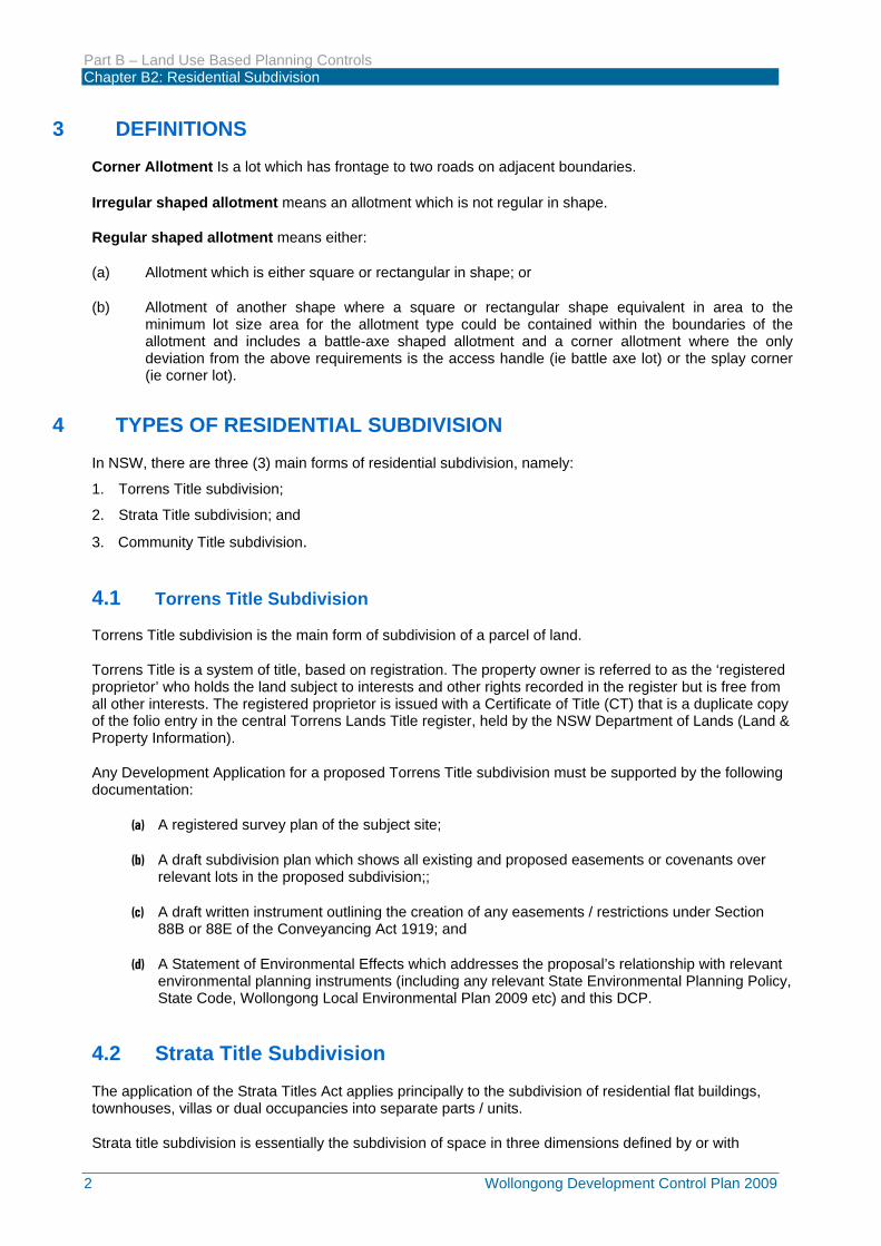
6. Where natural landform is sloping prior to subdivision works, lots shall be designed to reflect inherited slopes. Housing products to suit sloping lots, with building envelope platforms, landscaped sloping solutions and split-level house designs are encouraged (see diagrams below).
7. All finished lots shall have a minimum 2% fall towards the proposed stormwater drainage system, in order to allow for suitable stormwater run-off from the site and to help minimise any potential water ponding.
Examples of incorporating sloping in lots from front to rear into lot design and related housing designs.
Part B – Land Use Based Planning Controls Chapter B2: Residential Subdivision
6 Wollongong Development Control Plan 2009
Examples of accommodating sloping blocks into lot design and related housing designs.
6 SUBDIVISION DESIGN Subdivision layouts are to incorporate adequate pedestrian, bicycle and vehicle links to the road network, public transport nodes, pedestrian/cyclist network, and public open space areas. The street and subdivision layout should minimise fuel use by reducing travel distances and maximising public transport effectiveness. Connectivity within neighbourhoods is essential to ensure the majority of dwellings are within 400 metres walking distance to bus stops.
1. The design of any residential subdivision must include a land suitability assessment, addressing
the following issues where relevant:
• Existing land use.
• Flooding.
• Bushfire.
• Topography, geotechnical constraints, contamination constraints.
• Biodiversity (Ecologically Endangered Communities, bushland, significant trees, habitat).
• Known or likely heritage sites, including Indigenous heritage cultural issues.
• Existing road network.
• Street frontage and access.
• Available utilities & services and existing easements.
• Need for community and recreation facilities.
• Visual character.
• Noise impacts (e.g. from the main roads, industrial areas or public and private railways).
2. Subdivisions comprising 4 lots or more must demonstrate the following where applicable:
• Proposed road layout and hierarchy.
• Proposed public transport, bicycle and pedestrian routes.
• Proposed drainage management concepts.

Part B – Land Use Based Planning Controls Chapter B2: Residential Subdivision
Wollongong Development Control Plan 2009 7
• Proposed buffers to heritage items.
• Riparian corridors, buffers and proposed future use and ownership.
• Proposed Asset Protection Zone requirements.
3. Refer to Council’s Subdivision Policy for general subdivision design and the construction requirements for roads, stormwater drainage, utility services etc.
6.1 Lot layout – Aspect and solar access Objectives
(a) To ensure residential lots are well designed to take into account major factors in creating desirable landuse outcomes for the built environment through aspect, orientation, slope issues and optimal solar access.
(b) To provide residential lots which maximises solar access and energy efficiency opportunities for future dwellings and private open space areas.
Development Controls
1. Roads running generally east – west are preferred since they provide for lots with a north-south axis which caters for optimum solar access to dwellings and private open space. Lots with a main north-south axis (20ºW to 30°E) provide the best flexibility for the siting of future dwellings and reduce potential overshadowing problems.
2. Lots with a main east-west axis (ie roads running north-south) should be widened, in order to ensure satisfactory solar access opportunities into living rooms of future dwellings and rear private open space areas and to help prevent overshadowing of dwellings and private open space on adjoining lots.
3. Lots with a NW – SE or NE – SW axis are less favourable and may need to be specifically designed or larger than normal to allow for the siting of a dwelling which is not directly parallel to the boundaries.
4. Lots should be rectangular shaped rather than irregular shaped, wherever practicable, in order to maximise solar access opportunities. Lots on the southern side of any road should have a greater frontage to the road, to allow improved solar orientation for the future dwelling.
5. Wherever possible, an access way to a rear battle-axe lot should be located on the southern side of an allotment, to minimise any potential overshadowing of future adjoining dwellings.
6. Any subdivision proposal adjoining a rear lane shall be designed so as to provide clear building frontage and pedestrian / visitor access between future building and the front road.
6.2 Lot size 1. The minimum subdivision allotment size requirement for a particular parcel of land shall be in
accordance with the provisions of Wollongong LEP 2009 and the accompany Lot Size Map, relevant to the land.
2. Irregular shaped lots shall have a minimum allotment size of 485m2. 3. Regular shaped corner lots shall have a minimum allotment size of 500m2 as per Table 1 below
and as illustrated in Figure 1 below. 4. Regular shaped battle axe allotments within residential zones shall have a minimum allotment size
of 550m2, excluding the battle axe access handle. Irregular shaped battle – axe lots shall have a minimum allotment size of 600m2 (excluding the access handle). Refer to Figure 1 and Table 1 below.
Table 1. Minimum allotment sizes
Allotment Type Minimum Lot Size Requirement for Regular
Shaped Lots
Minimum Lot Size Requirement for Irregular Shaped Lots
Standard Lot Subject to Wollongong Local Environmental Plan 2009
485m2

Part B – Land Use Based Planning Controls Chapter B2: Residential Subdivision
8 Wollongong Development Control Plan 2009
(relevant Lot Size Map) Corner Lot 500m2 NA
Battle-axe Lot (excluding access handle)
550m2 600m2
However, larger allotments may be required in certain circumstances such as lots containing steeply sloping land or land containing a watercourse or land fronting an arterial road.
Figure 1. Solar Access Orientation – Minimum Building Envelopes and Lot Widths
6.3 Lot width and depth Objectives
e) To ensure residential lots are designed to provide sufficient lot width and depth, to cater for a suitable range of dwelling styles having regard to any site constraints or environmental qualities of that land.
f) To ensure residential lots in low density residential areas provide sufficient site area to cater for detached dwelling-houses with sufficient rear private open space which gains appropriate sunlight access during mid-winter.
Development Controls
1) A minimum 12 metre lot width is required for residential allotments with N to NE rear boundary alignment.
2) Lots with a NW, W, SW, S, SE or E alignment should be 15 metres wide at the front building alignment, in order to ensure satisfactory solar access opportunities into living rooms of future dwellings and rear private open space areas and to help prevent overshadowing of dwellings and

Part B – Land Use Based Planning Controls Chapter B2: Residential Subdivision
Wollongong Development Control Plan 2009 9
private open space on adjoining lots.
3) A minimum 15 metre lot width may be required where Council determines on-street parking is required.
4) The minimum depth for a residential allotment should be at least 25 metres.
6.4 Battle-axe lots Objectives (a) To encourage conventional residential subdivisions with direct public road access, rather than a
series of battle axe allotments one behind each other, in order to maintain the residential amenity and character of the locality.
(b) To minimise the potential adverse streetscape and amenity impacts upon the locality arising from a number of battle axe lots sharing common access corridors.
(c) To ensure each battle axe lot has a sufficient site area with a suitable building envelope to accommodate a range of different dwelling styles, in order to minimise any potential amenity or privacy impacts upon adjoining residential properties.
(d) To ensure each battle axe lot has a sufficient site area to provide satisfactory on-site parking with suitable vehicular access and maneuvering areas.
Development Controls
1. The minimum allotment size requirement for battle-axe lots shall be in accordance with the relevant LEP and accompanying Lot Size Map, excluding the site area required for the battle-axe lot access handle.
2. The minimum lot width for a battle-axe allotment shall be 15 metres as measured at the front building line (ie exclusive the access handle). The 15 metre minimum lot width requirement for battle axe lots is set at 6 metres from the end of the battle axe handle (ie within the main building portion of the site).
3. A maximum of two (2) battle-axe allotments will be permitted behind an allotment which has direct frontage to a dedicated public road in the proposed subdivision. This allows for inherent site constraints such as slope or topography which may otherwise prevent a conventional residential subdivision providing direct public road access to all lots. Under no circumstances will Council favourably consider any subdivision proposal involving a series of battle-axe lots, one behind each other.
4. All battle-axe allotments must have direct access to a dedicated public road, through the provision of an access handle attached to each battle-axe lot or via a shared access corridor (ie maximum of two (2) lots may share a common access corridor).
5. The minimum access corridor width for a battle axe allotment shall be 5 metres with a minimum road pavement width of 3 metres for the entire length of the access handle.
6. A 1 metre wide landscaping strip shall be provided along each side of the required 3 metre wide road pavement. The landscaping strip shall be planted with suitable small trees, shrubs and groundcovers.
7. A shared access corridor may be permitted for a maximum of two (2) battle axe allotments where, in the opinion of Council, the proposed access arrangement will satisfactorily cater for safe vehicular and pedestrian access to each of the lots and that satisfactory sight line distances are available between the subject lots and the public road.
8. Any access corridor shared between two (2) battle axe allotments must be created through reciprocal rights of carriageway under Section 88B of the Conveyancing Act 1919. The minimum shared access handle width shall be 5 metres with a minimum road pavement width of 3 metres for the entire length of the access handle. However, the shared access handle must be designed wide enough to satisfactorily cater for the placement of garbage and recycling bins (ie associated with the dwellings on the two battle axe lots) adjacent to the access handle road pavement
9. A minimum 1 metre wide landscaping strip must be provided along each side of the required 3

Part B – Land Use Based Planning Controls Chapter B2: Residential Subdivision
10 Wollongong Development Control Plan 2009
metre wide road pavement of any shared access handle. The landscaping strip shall be planted with suitable small trees, shrubs and groundcovers. A hard stand area on one side of the access handles for garbage and recycling bins (ie directly abutting the public road reserve). The opposite 1 metre wide landscaping strip in the shared access handle shall include letterboxes for the two lots (ie. directly abutting the public road reserve).
10. All battle-axe lot access corridors must be provided with all-weather road pavement. All access handle driveway crossings must be of a full concrete or asphalt construction and must be designed having regard to current fire regulations for fire hydrants. Driveways must be sited to allow for visibility of vehicles entering and leaving the site.
11. Driveway construction must give consideration to driveway drainage, utility servicing and retaining structures.
12. Within bush fire hazard areas, access to allotments shall be in accordance with the requirements of the NSW Rural Fire Service Planning for Bush Fire Protection 2006 guidelines. In the event of any inconsistency between the access requirements to lots between this part of the DCP and the Planning for Bush Fire Protection 2006 guidelines, the Planning and Bush Fire Protection guidelines.
13. Each battle axe access corridor must have capacity for vehicular turning facilities and two (2) on- site parking spaces must be provided for each battle axe lot.
14. Access corridors within bush fire prone areas must provide a suitable turning area, in order to enable the satisfactory maneuvering of fire fighting vehicles in accordance with the requirements of the NSW Rural Fire Service Planning for Bush Fire Protection 2006 guidelines will prevail.
15. The maximum gradient for any access way required for a battle axe lot subdivision should be 25%.
16. The gradients for access handles for allotments within bush fire prone areas shall be in accordance with the requirements of the NSW Rural Fire Service Planning for Bush Fire Protection 2006 guidelines.
17. Stormwater drainage on driveways must be contained in kerbs or a central dish and conveyed to the Council stormwater drainage system via the public road.
6.5 Building envelopes Objectives
(a) To ensure each residential lot has a suitable building envelope to accommodate a range of different dwelling styles, in order to minimise any potential amenity or privacy impacts upon adjoining residential properties.
(b) To ensure the building envelope for each residential lot, takes into account all relevant constraints of the site and / or any easement or other restrictions pertaining to the land.
(c) To ensure the building envelope for each residential lot takes into account any area of the subject land which contains significant remnant trees or other significant vegetation (including riparian vegetation).
(d) To ensure building envelopes are appropriately positioned to maximise solar access opportunities and energy efficiency for future dwellings and rear private courtyards for each residential lot.
Development Controls
1. Council may require residential lots to provide a specific rectangular building envelope with minimum dimensions of 15 metres (depth) x 10 metres (width), where the subject site contains any inherent site constraint(s) (eg flooding, geotechnical constraints etc) or contains significant remnant vegetation, any threatened flora species, endangered ecological community etc. Any such building envelope shall be exclusive of the required setback requirements for a dwelling - house as per Chapter B1: Residential Development.
2. A 15 metre (depth) x 10 metre (width) building envelope will be required for any proposed battle axe allotment upon land zoned R2 Low Density Residential, since the erection of a two storey .dwelling on a battle axe allotment is not permitted for land zoned Residential R2, under Chapter B1: Residential Development. Therefore, a building envelope is required to provide a sufficient building platform, to cater for a single storey dwelling.

Part B – Land Use Based Planning Controls Chapter B2: Residential Subdivision
Wollongong Development Control Plan 2009 11
3. Any proposed building envelope shall be shown on the required subdivision concept layout plan accompanying the Development Application. Additionally, any existing easements or other restrictions on the use of the land should be shown on the required subdivision layout plan.
Note: In the event that Council ultimately supports the proposed subdivision, a condition of consent may be imposed requiring the imposition of a restriction on the use of land pursuant to the provisions of Section 88B of the Conveyancing Act 1919 which shows the building envelope for each lot within the subdivision. This requirement may apply to certain subdivisions where sites are subject to inherent site constraints (eg geotechnical /slope instability issues etc) or contain significant vegetation, threatened flora or fauna, flood prone / riparian land or other constraints which may require the building envelope to be specifically identified on the lot(s).
6.6 Superlots in residential subdivisions for integrated housing or
medium density housing Objectives
(a) To ensure large residue lots or super lots for future dual occupancy or medium density housing are well planned and are strategically placed to reflect future traffic management conditions and other environmental conditions.
(b) To encourage large residue lots to be earmarked for medium density housing early in the residential subdivision process.
Development Controls
1. The configuration and lot size of residue or super lots shall be designed to meet the future planning requirements for either dual occupancy, multi dwelling development or residential apartment building developments contained in this DCP. Accordingly, the subdivision plan accompanying the Development Application shall indicate the intended future residential use of the residue lot.
2. In the event that the residue lots are not designed to comply with the future planning requirements for the intended future residential development, then a reduced dwelling yield may occur when the Development Application for the development of the residue lot is assessed.
3. Large residue lots should be located in strategically placed locations in subdivisions and generally not at the end of cul-de-sacs. However, in certain circumstances, the positioning of a residue lot at the end of a cul-de-sac may be supported where individual site circumstances such as traffic management and other environmental conditions, support this arrangement.
6.7 Existing easements Objectives
(a) Guide the use of land under electrical easements for appropriate urban purposes.
(b) Guide the use of land over gas easements for appropriate land uses. Development Controls 1. A Development Application shall include the proposed use of all land under easements. 2. Water management can be carried out in electrical easements 3. Landscape planting (low rise) can be established in electrical easements while allowing for
necessary service access. 4. More significant planting can happen on the edge of electrical easements to create a visual buffer
to electrical infrastructure 5. Recreational uses and open space can be established within easements. 6. Easements can be used for roads, pedestrian and bicycle routes subject to approval by the
easement authority.

Part B – Land Use Based Planning Controls Chapter B2: Residential Subdivision
12 Wollongong Development Control Plan 2009
7. Consultation with the asset owner (eg. TransGrid, Endeavour or Jemena) is required to ensure that buffers, road levels and access are adequate.
7 MAJOR RESIDENTIAL SUBDIVISIONS A major subdivision is considered to be a subdivision of lots creating more than 15 lots and/or applies to an area greater than 3600m2 and creating an increase to the number of dwellings in the site.
If the subdivision is within an urban release area the development may have additional staging and sequencing requirements relating to development Concept, Precinct Plan or Neighbourhood Plans (eg. DCP Chapter D16: West Dapto Urban Release Area).
Objectives
(a) To ensure the staging of a major residential subdivision is well planned and that all relevant roads, drainage and other infrastructure services are provided for each stage in the subdivision.
(b) To ensure the staging of the development minimises any potential adverse noise or amenity conflicts, arising from construction equipment and plant operating on later subdivision stages upon residents in early release stages.
Development Controls
1. In cases of a major residential subdivision, a staging plan will be required which shows the proposed staging program. Additionally, the Statement of Environmental Effects shall provide a detailed outline of the proposed staging program, including the proposed total number of lots within each relevant stage.
2. The subdivision staging should be designed to minimise conflicts arising from construction plant and equipment operating during the construction of later subdivision stages impacting upon the amenity of residents living in dwellings within the earlier subdivision stages. This may also require the provision of temporary access arrangements for heavy vehicles associated with the stages under construction separate from the first stage(s) of the subdivision. The provision of suitable landscaping treatment and / or acoustic walls may also be necessary to minimise potential privacy, amenity or noise impacts upon first stage residents.
3. In the event that the staging of the subdivision is approved, all necessary subdivision works (including road works, drainage works, water and sewerage infrastructure, telecommunications, electricity supplies etc) must be completed for each relevant stage, prior to the release of any Subdivision Certificate.
8 PUBLIC RESERVES AND OPEN SPACE Objectives
a) To ensure the provision and embellishment of public open space is consistent with Council’s planned requirements, to meet the recreational needs of the community.
b) To provide public open space (ie both active and passive) within reasonable proximity for all residential lots within existing urban areas and new release areas.
c) To preserve remnant native bushland including endangered ecological communities within public open space buffers, where possible.
d) To limit the amount of land proposed to be dedicated to Council for public open space, to only lands zoned RE1 Public Recreation, under the relevant LEP or other lands previously identified by Council as being required for public open space.
e) To minimise costs of on-going maintenance of public open space.
Development Controls
1. The size and location requirements for public open space shall fall within a hierarchy of provisions in accordance with Council infrastructure planning and generally as indicated in Table 2. Exact

Part B – Land Use Based Planning Controls Chapter B2: Residential Subdivision
Wollongong Development Control Plan 2009 13
location and the level of equipment or other embellishment required for the open space must be discussed with Council upfront, prior to the lodgment of the Development Application, where such open space is proposed to be dedicated to Council for a public reserve or other purposes.
Table 2. Size and Location Criteria for Public Open Space
Open space type Minimum Area Maximum walking catchment
Local open space 1-2 hectares 400-600 metres
Neighbourhood open space 2-4 hectares 2km via road or pedestrian/ bicycle networks
District open space 5-8 hectares Ward based catchments (3 wards of Wollongong LGA)
Note: Whilst Council may have had preliminary discussions with an applicant upfront over the possible future dedication and embellishment of land for public reserve(s), there is no guarantee that the proposed subdivision will be ultimately approved until such time as the application is properly assessed and determined on its merits, based on the “Matters for Consideration” as listed under Section 79C of the Environmental Planning and Assessment Act 1979.
2. Council will not accept the dedication of land for the purposes of public reserve where in the opinion of Council, there is already sufficient public open space in the locality and / or the land is not zoned RE1 Public Recreation.
3. Any approved public reserve lot shall be fully embellished in accordance with Council’s requirements, prior to the release of the Subdivision Certificate.
4. Private open space may be provided as community lots in a Community Title subdivision. Any small open space area in a Community Title subdivision should be at least 500m2 - 1,000m2 in area and should make provision for seating as well as provision for an integrated children’s playground equipment.
5. Wherever possible, riparian corridors should form the ‘spine’ for public open space within a subdivision.
9 PEDESTRIAN AND BICYCLE NETWORKS Objectives
(a) To ensure residential subdivisions provide safe and convenient pedestrian and bicycle linkages to facilities and services within the surrounding locality.
(b) To ensure the road network adequately caters for the safety of pedestrians, cyclists and motorists through the provision of adequate sight lines at critical locations such as intersections, driveway crossings, bus stops and crossing points.
(c) To ensure all pedestrian footpaths, and shared paths are designed in accordance with relevant Australian Standards and AUSTROADS.
(d) To ensure all pedestrian footpaths and shared paths are designed to incorporate Crime Prevention Through Environmental Design (CPTED) principles.
Development Controls
1. Any residential subdivision should identify the overall layout of dedicated pedestrian footpaths and shared paths within the subdivision. The constructed pedestrian footpath shall be a minimum width of 1.5 metres. For any shared path, a minimum 2.5 metre width is required and widened to 3 metres if the shared path is on a Minor Collector (Type 4) road.
2. Pedestrian and shared paths should be provided to link roads including cul-de-sacs and to directly access public transport routes/bus stops, public reserves, sporting / community facilities, schools, business precincts and adjacent residential subdivisions.

Part B – Land Use Based Planning Controls Chapter B2: Residential Subdivision
14 Wollongong Development Control Plan 2009
3. All pedestrian footpaths or shared paths should be designed in accordance with the requirements of relevant Australian Standards, AUSTROADS Guides and Council’s Subdivision Policy as appropriate. All paths should be constructed of concrete, except where varied by Council.
4. Safe pedestrian crossings are to be created with the use of pedestrian refuges, slow points, kerb extensions or other appropriate measures, designed in accordance with relevant Australian Standards and AUSTROADS Guides.
5. All footpaths and shared paths are to be provided with appropriate lighting and designed to incorporate Crime Prevention Through Environmental Design (CPTED) principles by minimising any potential hiding places and maximising passive surveillance.
6. The full design details of any footpaths, shared paths, pedestrian crossings or any other associated infrastructure shall be clearly shown on the subdivision plans submitted with the Development Application.
(Note: “shared path” refers to a path that is shared by both pedestrians and cyclists)
10 ACOUSTIC ASSESSMENT Objective
(a) Ensure appropriate acoustic measures are planned for and provided for subdivisions which are subject to potential adverse noise impacts, in order to provide a pleasant acoustic environment for all residential lots within the subdivision.
Development Controls
1. Council will refer to NSW Roads and Maritime Services (RMS) and Department of Planning to determine if an acoustic assessment is required as outlined in “Development near Rail Corridors and Busy Roads – Interim Guidelines” (Department of Planning).
2. When required, full details of the proposed acoustic mediation shall be submitted with the Development Application.
11 STREET TREE PLANTING Objectives
(a) To provide suitable street trees within residential subdivisions, in order to improve the streetscape character of the locality.
(b) To improve the general residential amenity of the subdivision.
(c) To ensure the planting of street trees in new subdivisions is appropriate and compatible with existing street tree planting within certain suburbs in the city.
Development Controls
1. The planting of street trees shall be integrated with driveway crossings, utility services, street lighting and shall be undertaken in accordance with the general requirements contained in the Chapter E6: Landscaping in this DCP.
2. Council may require the planting of a specific tree species for certain roads in a subdivision, especially if there is already an existing street tree scheme in the suburb. This requirement will be determined by Council as part of the assessment of the Development Application.
12 ENTRY STATEMENTS Objectives
(a) Ensure entry statements are appropriately designed and constructed to enhance the streetscape character of the residential estate.

Part B – Land Use Based Planning Controls Chapter B2: Residential Subdivision
Wollongong Development Control Plan 2009 15
(b) Ensure all entry statements and supporting structures (including night lighting) are contained wholly within the private realm of the subdivision, rather than within any existing or proposed future public road reserve.
(c) Ensure all entry statements minimise any potential obstructions to motorists, pedestrians and cyclists and to prevent any potential adverse traffic visibility impact and / or visual distraction to motorists.
Development Controls
1. Entry statements mark and define the entry to a residential estate and are designed to enhance the streetscape character of the estate.
2. All entry statements (including associated special effects and night lighting) at the entry to residential subdivisions must be contained wholly within the private property and not within any land proposed to be dedicated as public road reserve.
3. The location and form of the entry statement must not unduly impede or restrict pedestrian, cyclist or public and private vehicular movement to or from the site. The siting and design of an entry statement must not reduce traffic visibility on adjacent roads and should not cause an unsafe visual distraction to vehicle drivers.
4. The entry statement should also be designed to incorporate Crime Prevention through Environmental Design (CPTED) principles by minimising any potential hiding places.
5. The full design details of the proposed entry statement(s) shall be shown on the required Landscape Plans to be submitted with the Development Application.
13 TRAFFIC FACILITIES
13.1 Road connectivity, permeability and legibility
Objectives
(a) To establish a legible and well connected road network that promotes safe pedestrian and bicycle movement as well as convenient vehicular access.
(b) To provide improved road, pedestrian and bicycle connections linking residential areas with public reserves, business centres, public services and facilities.
Development Controls
1. New subdivision roads should be designed to be integrated and connected with the existing local road network of the surrounding neighbourhood, wherever possible. In new subdivisions, cul-de-sacs should be minimised, wherever possible, in order to ensure connectivity within an estate.
2. Road design taking into account the surrounding local road network in the locality, especially the existing road hierarchy.
3. The subdivision design must achieve a high level of vehicular permeability and legibility in the location and layout of the road pattern.
4. The integration of new subdivision roads with existing roads will help to:
(a) Improve interconnections and minimise travel distances to / from facilities and services;
(b) Provide a choice of routes; and
(c) Spread traffic loads throughout the local road network, rather than intensifying traffic volumes to a restricted number of roads.
5. Connected grid networks are preferred as they provide more walkability and improve safety when dwellings are sited to address block edges, to enable passive surveillance.
6. The road network should provide internal connectivity to allow for a distributed traffic flow as well as encourage walking and cycling within the subdivision and wider area.

Part B – Land Use Based Planning Controls Chapter B2: Residential Subdivision
16 Wollongong Development Control Plan 2009
7. Pedestrian footways and shared paths should be safe and convenient to encourage alternative transport options to motor vehicles.
8. A larger subdivision involving 50 or more residential lots should be designed to minimise any excessive “backtracking”. Therefore, the creation of multiple cul-de-sacs and “no through” roads within a larger subdivision is discouraged.
9. Developments that include commercial /retail or business that will generate employment for more than 50 people should develop and submit a Workplace Travel Plan that demonstrate there will be facilities provided to encourage positive active transport and public transport outcomes.
13.2 Road hierarchy and design requirements
Objectives
(a) To provide a defined hierarchy of roads, in order to provide an acceptable level of access, safety and convenience for all road users.
(b) To ensure that the design features of each residential road within a subdivision reflects the role of the road within the overall road network.
(c) To provide an acceptable level of access, safety and convenience for all road users within existing urban areas and new release areas, whilst ensuring acceptable levels of amenity and minimising traffic management issues in the particular locality.
(d) To provide appropriate road access for larger and special purpose vehicles including garbage and recycling trucks, fire trucks, delivery trucks etc.
(e) Ensure sufficient road carriageway and verge widths are provided for each road type, in order to enable all roads to perform their designated function within the road network.
(f) Ensure that the road reserve adequately caters for all required functions including safe and efficient vehicular and pedestrian movement throughout the road network, provision of on-street parking and the provision of street tree planting and other landscaping, where appropriate.
(g) Ensure road verges are of sufficient width to physically accommodate all necessary infrastructure assets and utilities.
(h) Provide road geometry that is consistent with the designated function of the specific road as well as the physical characteristics of the locality.
(i) Ensure the road network is simple and safe for all road users, including motor vehicles, pedestrians and cyclists.
(j) Ensure that appropriate vehicle speed limits are incorporated into the road design to enhance the safety of pedestrians and cyclists, the young and people with a disability.
(k) Ensure new release areas are designed to provide for safe, convenient and efficient bus routes.
Development Controls
1 The design of any road as part of a subdivision shall be in accordance with the following Table 3, Table 4 and Table 5, the Road Type Cross-Sections accompanying this section 14.2 and in accordance with Council’s Subdivision Policy.
2 Roads should be designed to provide visual interest in the streetscape through kerbs (where appropriate), landscaping and paving treatments. The road design should be compatible with the existing road pattern in the locality.
3 The minimum spacing of staggered intersections in a local subdivision road network (Road Types 5 to 8) should be 20 metres.

Part B – Land Use Based Planning Controls Chapter B2: Residential Subdivision
Wollongong Development Control Plan 2009 17
4 Street layout and curve radii must make provision for service vehicles to manoeuver.
5 The provisions of the NSW Rural Fire Service publication “Planning for Bushfire Protection” and the State Government Publication “Fire Safety Guideline – Access for Emergency Vehicles and Emergency Service Personnel” must be met and will take precedence.
6 The maximum length of cul-de-sacs should not exceed 80 metres.
7 For all roads that permit direct driveway access, a minimum 15 metre lot width may be required at the street frontage, where Council determines that on-street parking is required.
8 Angled parking may be utilised adjacent to active open space and in town and village centres, particularly for lower volume roads, provided it does not unduly impact traffic flow or public transport services. Angled parking must comply with Australian Standards and will be assessed by Council as to its merits on a case-by-case basis.

Part B – Land Use Based Planning Controls Chapter B2: Residential Subdivision
18 Wollongong Development Control Plan 2009
Table 3. Road network environment
Road Environment
Street Types Access (driveway)
Indicative Daily Traffic
Volume (vpd)
Target Speed (km/h)
Street Pavement
Type Parking
Sub-Arterial Road
Type 1 (entry road with WSUD median strip (4.2m) &
bus services)
No Access 20,000 - 40,000+ 70 Asphalt No
Type 2 (with bus services) No Access 15,000 -
20,000+ 60 Asphalt No
Type 2A (with parking & bus
services) No Access 10,000 -
15,000 60 Asphalt Yes
Major Collector
Road
Type 3 (with parking & bus
services) No Access 3,000 -
15,000 60 Asphalt Yes
Minor Collector
Road
Type 4 (with parking & limited
bus access) Access 3,000 -
9,000 50 Asphalt Yes
Town & Village Centre Road
Type TC Limited Access (varies) 40 Asphalt Yes
Local Road Type 5 (with parking) Access 1,000 -
3,000 40 Asphalt Yes
Access Street
Type 6 (with residential on both
sides, and parking) Access 300 - 1,000 25 Asphalt Yes
Access Place
Type 7 (with parking) Access < 300 25 Asphalt Yes
Type 7A (1-Way, adjacent open
space on one side) Access < 300 25 Asphalt Yes
Type 7B (2-Way, adjacent open
space on one side) Access < 300 25 Asphalt Yes
Laneway Type 8 (no parking) Access < 150 10 Asphalt No

Part B – Land Use Based Planning Controls Chapter B2: Residential Subdivision
Wollongong Development Control Plan 2009 19
Table 4. Carriageways and verges
Carriageway Verge
Street Types Kerb Lane (m)
Centre Lane (m)
Total (m) Verge (m)
Total Reserve
(m)
Footpath (m)
Shared Path (m)
Sub-Arterial Road
Type 1 (entry road with WSUD median strip (4.2m) &
bus services)
3.6 3.4 18.2 10.5 (5.25 each side) 28.7 n/a
5m (2.5m each
side)
Type 2 (with bus services) 3.5 3.2 13.4 9.5
(4.75 each side) 22.9 n/a 5m
(2.5m each side)
Type 2A (with parking & bus
services) 3.5 3.2 13.4 9.5
(4.75 each side) 22.9 n/a 5m
(2.5m each side)
Major Collector
Road
Type 3 (with parking & bus
services) 3.0 3.2 12.4 9.5
(4.75 each side) 21.9 n/a 5m
(2.5m each side)
Minor Collector
Road
Type 4 (with parking & limited
bus access) 2.6 3.0 11.2
9.75m (5.25m one side, 4.5m other side)
20.95 1.5 3m
Town & Village Centre Road
Type TC (varies) (varies) (varies)
9m (4.5m each side)
or 9.75m (5.25m residential side,
4.5m centre side)
(varies)
4.5m full width town
centre side
3m provided on one side if
residential
Local Road Type 5 (with parking) 2.1 2.8 9.8 9m
(4.5m each side) 18.8
3m (1.5m each side)
n/a
Access Street
Type 6 (with residential on both
sides, and parking) 2.3 3.5 8.1 9m
(4.5m each side) 17.1
3m (1.5m each side)
n/a
Access Place
Type 7 (with parking) 3.5 n/a 7.0 8m
(4m each side) 15 n/a n/a
Type 7A (1-Way, adjacent open
space on one side)
2,0 (parking lane) or
3.5 (travel lane)
n/a 5.5
6.45m (2.45m open
space side, 4m other side)
11.95 n/a n/a
Type 7B (2-Way, adjacent open
space on one side) 3.5 n/a 7.0
6.45m (2.45m open
space side, 4m other side)
13.45 n/a n/a
Laneway Type 8 (no parking) n/a n/a 5.5
2.9m (1.45m each
side to property boundary)
8.4 n/a n/a

Part B – Land Use Based Planning Controls Chapter B2: Residential Subdivision
20 Wollongong Development Control Plan 2009
Table 5. Street vegetation
Street Types Verge Trees Street Tree Planting
Sub-Arterial Road
Type 1 (entry road with WSUD median strip (4.2m) &
bus services)
1 every 12m n/a
Type 2 (with bus services) 1 every 12m n/a
Type 2A (with parking & bus
services) 1 every 12m 1 every 30-60m
via kerb bulges
Major Collector
Road
Type 3 (with parking & bus
services) 1 every 12m 1 every 30-60m
via kerb bulges
Minor Collector
Road
Type 4 (with parking & limited
bus access) 1 per lot or every 15-20m None – use kerb extensions
at intersection
Town & Village Centre Road
Type TC Landscape design or 1 per lot or every 15-20m
(residential side)
Kerb extensions can be used mid-block (eg at pedestrian crossings) and intersections
Local Road Type 5 (with parking) 1 per lot or every 15-20m None – use kerb extensions
at intersection
Access Street
Type 6 (with residential on both
sides, and parking) 1 per lot or every 15-20m None – use kerb extensions
at intersection
Access Place
Type 7 (with parking) 1 per lot or every 15-20m n/a
Type 7A (1-Way, adjacent open
space on one side)
1 per lot or every 15-20m (residential side) n/a
Type 7B (2-Way, adjacent open
space on one side)
1 per lot or every 15-20m (residential side) n/a
Laneway Type 8 (no parking)
1 per lot depending on lane design n/a

Part B – Land Use Based Planning Controls Chapter B2: Residential Subdivision
Wollongong Development Control Plan 2009 21
TYPE 1 – Major Sub-arterial road
Objectives
1. Provide for high general traffic and heavy vehicle volumes with 4 travel lanes.
2. Provide connectivity between neighbourhoods and local centres/arterial road network.
3. Direct access is not permitted (access denied).
4. Provide for bus routes and bus stops (generally indented stops).
5. Design speed 80km/h, posted speed 70km/h.
6. Provide legible pedestrian and cycle network via shared paths on both sides of road.
7. Provide improved safety and amenity through provision of planted median.
8. Allows for development of right turn lanes at intersections via the central median provision.
Notes
1. The median will include low planting and incorporate WSUD where appropriate.
2. The road capacity is considered to generally cater for greater than 15,000vpd.
3. Lighting can be provided in the median as well as within the verge.
4. A kerbside verge width of 2m has been provided for an improved buffer for pedestrians/cyclists to higher speed road traffic.
5. Barrier kerb used for kerbside lanes. 6. Travel lanes wider than other road types
reflective of higher speed limit and proportion of heavy vehicles.
7. Bus stops shall be via indented bus bays where practicable.
8. Intersections are to be controlled (signals, roundabouts) and provide appropriate pedestrian crossing facilities.
9. Priority controlled intersections will only be considered for left turns (eg Left-in/Left-out).
10. Controlled intersections (signals, roundabouts) are to be generally spaced a minimum of 400 metres apart.
11. Mid-block pedestrian crossings not permitted (eg refuges, marked crossings, kerb extensions etc).

Part B – Land Use Based Planning Controls Chapter B2: Residential Subdivision
22 Wollongong Development Control Plan 2009
TYPE 2 - Sub-arterial road with bus service
Objectives
1. Provide for high traffic volumes with 4 travel lanes.
2. Provide connectivity between neighbourhoods and local centres/higher order roads.
3. Direct access is not permitted (access denied). 4. Provide for bus routes and bus stops. 5. Design speed 70km/h, posted speed 60km/h. 6. Provide legible pedestrian and cycle network via
shared paths on both sides of road. 7. All adjoining lots must provide an active frontage
to the Type 2 road (can be direct frontage or via secondary parallel internal road).
Notes
1. The road capacity is considered to generally cater for greater than 15,000vpd.
2. Lighting can be provided within the verge. 3. A kerbside verge width of 1.5m has been
provided to allow for space for trees. 4. Barrier kerb to be provided. 5. Bus stops shall be provided in the kerbside lane. 6. Intersections are to be controlled (signals,
roundabouts) and provide appropriate pedestrian crossing facilities.
7. Priority controlled intersections will only be considered for left turns (eg Left-in/Left-out).
8. Controlled intersections (signals, roundabouts) are to be generally spaced a minimum of 400 metres apart.
9. Mid-block pedestrian crossings not permitted (eg refuges, marked crossings, kerb extensions etc).
10. Road reserve may need to be locally widened at intersections to allow for turn lane requirements.

Part B – Land Use Based Planning Controls Chapter B2: Residential Subdivision
Wollongong Development Control Plan 2009 23
TYPE 2A – Sub-arterial with bus service and parking
Objectives
1. Provide for moderate traffic volumes with 2 travel lanes and 2 parking lanes, with potential to provide 4-lane capacity when required.
2. Provide kerbside parking. 3. Allow for traffic calming and greening
opportunity through provision of regular kerb extensions in parking lane.
4. Provide connectivity between neighbourhoods and local centres/higher order roads.
5. Direct access is not permitted (access denied).
6. Provide for bus routes and bus stops. 7. Design speed 70km/h, posted speed 60km/h. 8. Provide legible pedestrian and cycle network
via shared paths on both sides of road. 9. All adjoining lots must provide an active
frontage to the Type 2A road (can be direct frontage or via secondary parallel internal road).
Notes
1. The road capacity is considered to generally cater for 10,000 - 15,000vpd.
2. Lighting can be provided within the verge. 3. A kerbside verge width of 1.5m has been
provided to allow for space for trees. 4. Barrier kerb to be provided. 5. Bus stops shall be provided in the kerbside
(parking) lane. 6. Intersections are to be controlled (signals,
roundabouts) and provide appropriate pedestrian crossing facilities.
7. Priority controlled intersections will only be considered for left turns (eg Left-in/Left-out).
8. Controlled intersections (signals, roundabouts) are to be generally spaced a minimum of 400 metres apart.
9. Mid-block pedestrian crossings generally not permitted (eg refuges, marked crossings, kerb extensions etc).
10. Road reserve may need to be locally widened at intersections to allow for turn lane requirements.

Part B – Land Use Based Planning Controls Chapter B2: Residential Subdivision
24 Wollongong Development Control Plan 2009
TYPE 3 - Major collector with bus service and parking
Objectives
1. Provide for moderate traffic volumes with 2 travel lanes and 2 parking lanes.
2. Provide kerbside parking. 3. Allow for traffic calming and greening opportunity
through provision of regular kerb extensions in parking lane.
4. Provide connectivity between neighbourhoods and local centres/higher order roads.
5. Direct access is generally not permitted (access denied) but may be considered dependent on traffic demand.
6. Provide for bus routes and bus stops. 7. Design speed 70km/h, posted speed 60km/h. 8. Provide legible pedestrian and cycle network via
shared paths on both sides of road. 9. All adjoining lots must provide an active frontage
to the Type 3 road (can be direct frontage or via secondary parallel internal road).
Notes
1. The road capacity is considered to generally cater for 3,000 - 15,000vpd.
2. Lighting can be provided within the verge. 3. A kerbside verge width of 1.5m has been
provided to allow for space for trees. 4. Barrier kerb to be provided. 5. Bus stops shall be provided in the kerbside
(parking) lane. 6. Intersections are to be generally controlled
(signals, roundabouts) and provide appropriate pedestrian crossing facilities.
7. Priority controlled intersections may be considered dependant on traffic demand.
8. Controlled intersections (signals, roundabouts) are to be generally spaced a minimum of 400 metres apart.
9. Mid-block pedestrian crossings may be considered based on traffic demand and location (eg refuges, marked crossings, kerb extensions etc).
10. Road reserve may need to be locally widened at intersections to allow for turn lane requirements.
Part B – Land Use Based Planning Controls Chapter B2: Residential Subdivision
Wollongong Development Control Plan 2009 25
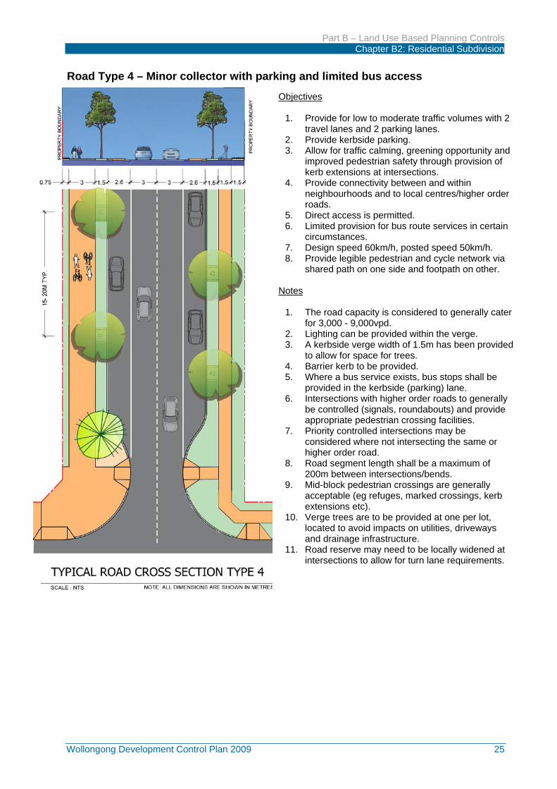
Road Type 4 – Minor collector with parking and limited bus access
Objectives
1. Provide for low to moderate traffic volumes with 2 travel lanes and 2 parking lanes.
2. Provide kerbside parking. 3. Allow for traffic calming, greening opportunity and
improved pedestrian safety through provision of kerb extensions at intersections.
4. Provide connectivity between and within neighbourhoods and to local centres/higher order roads.
5. Direct access is permitted. 6. Limited provision for bus route services in certain
circumstances. 7. Design speed 60km/h, posted speed 50km/h. 8. Provide legible pedestrian and cycle network via
shared path on one side and footpath on other. Notes
1. The road capacity is considered to generally cater for 3,000 - 9,000vpd.
2. Lighting can be provided within the verge. 3. A kerbside verge width of 1.5m has been provided
to allow for space for trees. 4. Barrier kerb to be provided. 5. Where a bus service exists, bus stops shall be
provided in the kerbside (parking) lane. 6. Intersections with higher order roads to generally
be controlled (signals, roundabouts) and provide appropriate pedestrian crossing facilities.
7. Priority controlled intersections may be considered where not intersecting the same or higher order road.
8. Road segment length shall be a maximum of 200m between intersections/bends.
9. Mid-block pedestrian crossings are generally acceptable (eg refuges, marked crossings, kerb extensions etc).
10. Verge trees are to be provided at one per lot, located to avoid impacts on utilities, driveways and drainage infrastructure.
11. Road reserve may need to be locally widened at intersections to allow for turn lane requirements.

Part B – Land Use Based Planning Controls Chapter B2: Residential Subdivision
26 Wollongong Development Control Plan 2009
Road Type TC – Town & Village Centre Road
Objectives
1. Provide a variation on Road Types 2-4 specifically for town and village centre environments.
2. Provide for low to moderate traffic volumes. 3. Provide kerbside parking and bus stops. 4. Allow for traffic calming, greening opportunity and
improved pedestrian safety through provision of kerb extensions mid-block &/or at intersections.
5. Provide connectivity to local centres/higher order roads.
6. Direct access may be considered on residential side (where relevant) depending on base road type and traffic demands.
7. Consolidation of access points to commercial development to maintain high level of pedestrian amenity and safety.
8. Allows for bus services. 9. Design speed generally 50km/h however road
design should seek to encourage lower speeds in these high pedestrian activity areas.
10. Provide improved pedestrian/cyclist amenity through provision of full width sealed paths on commercial frontages and shared path on any residential frontage.
Notes
1. The road capacity varies depending on base road type.
2. Lighting can be provided within the verge (or median if provided).
3. A kerbside verge width of 1.5m has been provided to allow for space for trees on residential frontage.
4. Barrier kerb to be provided. 5. Verge trees to be provided within paved area on
commercial frontage with tree grates and one tree per lot on residential side.
6. Planter boxes, bus shelters and street furniture will be considered for paved verge adjacent commercial development.
7. Bus stops shall be provided in the kerbside (parking) lane.
8. Intersections with higher order roads to generally be controlled (signals, roundabouts) and provide appropriate pedestrian crossing facilities.
9. Priority controlled intersections can be considered depending on base road type and traffic demands.
10. Mid-block pedestrian crossings are generally acceptable (eg refuges, marked crossings, kerb extensions etc).
11. Median treatments can be considered however base road type lane widths must still be provided.
12. Road reserve may need to be locally widened at intersections to allow for turn lane requirements.

Part B – Land Use Based Planning Controls Chapter B2: Residential Subdivision
Wollongong Development Control Plan 2009 27
Road Type 5 – Local Road with parking
Objectives
1. Provide for low traffic volumes, access to properties and amenity in residential areas.
2. Provide kerbside parking. 3. Allow for traffic calming, greening opportunity
and improved pedestrian safety through provision of kerb extensions at intersections.
4. Provide connectivity between and within neighbourhoods.
5. Direct access is permitted. 6. Not intended to cater for bus routes. 7. Design speed 60km/h, posted speed 50km/h. 8. Provide legible pedestrian access via footpaths
on both sides of road. Notes
1. The road capacity is considered to generally cater for less than 3,000vpd.
2. Lighting can be provided within the verge. 3. A kerbside verge width of 1.5m has been
provided to allow for space for trees. 4. Road segment length shall be a maximum of
200m between intersections/bends. 5. Barrier kerb to be provided. 6. Intersections will generally be priority control
however small roundabouts may be used for traffic calming (eg to break up long sections of road) &/or at 4-way intersections.
7. Traffic calming measures can be used to reduce the likelihood of through-traffic use (rat running).
8. Mid-block pedestrian crossings are generally acceptable (eg refuges, marked crossings, kerb extensions etc).
9. Verge trees are to be provided at one per lot, located to avoid impacts on utilities, driveways and drainage infrastructure.
10. Shared path is required (2.5m width) if the street forms part of a dedicated off-road cycle route (eg riparian shared path route).

Part B – Land Use Based Planning Controls Chapter B2: Residential Subdivision
28 Wollongong Development Control Plan 2009
Road Type 6 – Access Street
Objectives
1. To provide access to properties and amenity in residential areas.
2. Allows for some casual on-street parking. 3. Allow for traffic calming, greening opportunity and
improved pedestrian safety through provision of kerb extensions at intersections.
4. Provide connectivity within neighbourhoods/subdivisions.
5. Direct access is permitted. 6. Does not cater for buses. 7. Design speed 60km/h, posted speed 50km/h. 8. Provide legible pedestrian access via footpaths on
both sides of road. Notes
1. The road capacity is considered to generally cater for less than 1,000vpd.
2. Lighting can be provided within the verge. 3. A kerbside verge width of 1.5m has been provided to
allow for space for trees. 4. Road segment length shall be a maximum of 200m
between intersections/bends. 5. Barrier kerb to be provided. 6. Intersections will generally be priority control. 7. Verge trees are to be provided at one per lot, located
to avoid impacts on utilities, driveways and drainage infrastructure.
8. Shared path is required (2.5m width) if the street forms part of a dedicated off-road cycle route (eg riparian shared path route).
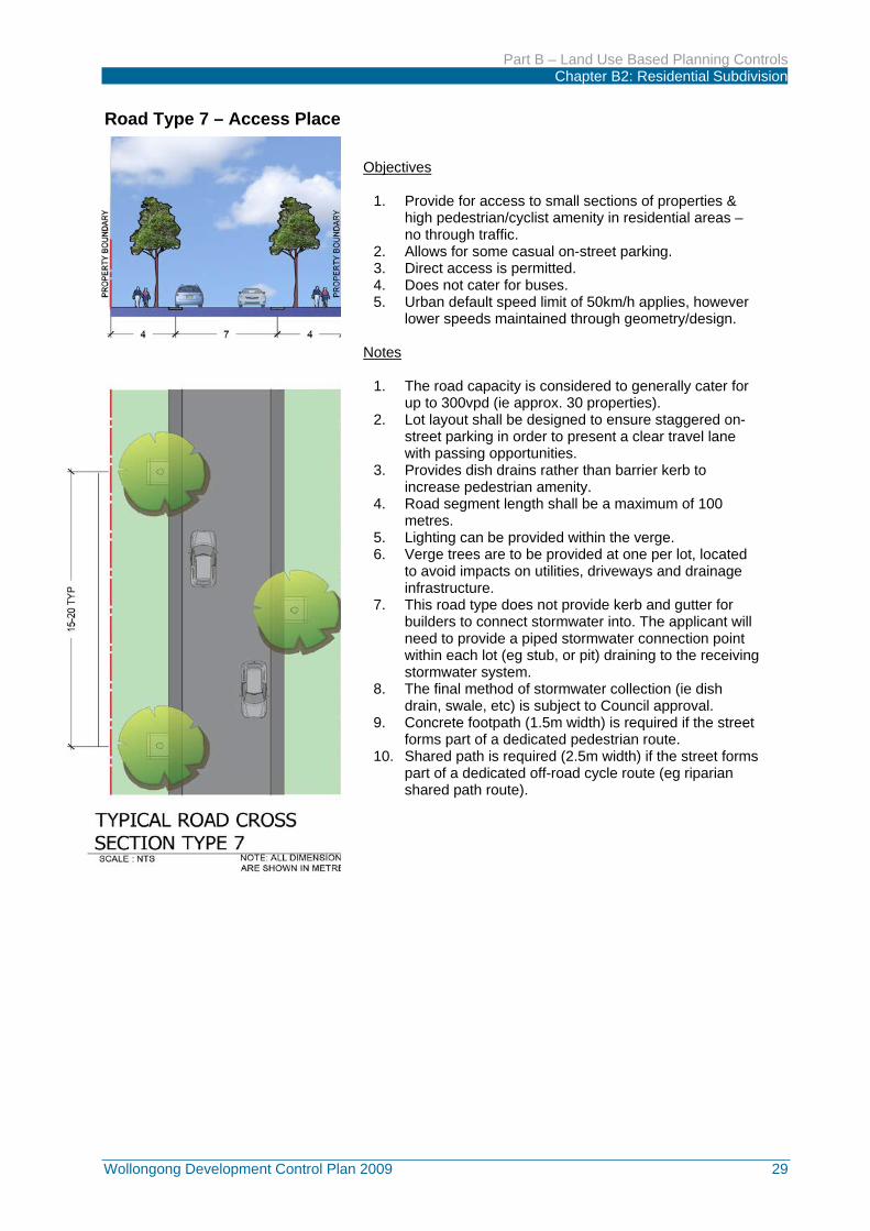
Part B – Land Use Based Planning Controls Chapter B2: Residential Subdivision
Wollongong Development Control Plan 2009 29
Road Type 7 – Access Place
Objectives
1. Provide for access to small sections of properties & high pedestrian/cyclist amenity in residential areas – no through traffic.
2. Allows for some casual on-street parking. 3. Direct access is permitted. 4. Does not cater for buses. 5. Urban default speed limit of 50km/h applies, however
lower speeds maintained through geometry/design. Notes
1. The road capacity is considered to generally cater for up to 300vpd (ie approx. 30 properties).
2. Lot layout shall be designed to ensure staggered on-street parking in order to present a clear travel lane with passing opportunities.
3. Provides dish drains rather than barrier kerb to increase pedestrian amenity.
4. Road segment length shall be a maximum of 100 metres.
5. Lighting can be provided within the verge. 6. Verge trees are to be provided at one per lot, located
to avoid impacts on utilities, driveways and drainage infrastructure.
7. This road type does not provide kerb and gutter for builders to connect stormwater into. The applicant will need to provide a piped stormwater connection point within each lot (eg stub, or pit) draining to the receiving stormwater system.
8. The final method of stormwater collection (ie dish drain, swale, etc) is subject to Council approval.
9. Concrete footpath (1.5m width) is required if the street forms part of a dedicated pedestrian route.
10. Shared path is required (2.5m width) if the street forms part of a dedicated off-road cycle route (eg riparian shared path route).

Part B – Land Use Based Planning Controls Chapter B2: Residential Subdivision
30 Wollongong Development Control Plan 2009
Road Type 7A – Access Place adjacent to open space (one-way traffic)
Objectives
1. Provide for access to small sections of properties & high pedestrian/cyclist amenity in residential areas – no through traffic.
2. Provide for informal access to open space, whilst not generating any more than 300vpd.
3. Allows for some casual on-street parking. 4. Direct access is permitted. 5. Does not cater for buses. 6. Urban default speed limit of 50km/h applies,
however lower speeds maintained through geometry/design.
Notes
1. This road is one-way and only permitted adjacent to open space and excludes sporting fields.
2. The road capacity is considered to generally cater for up to 300vpd (ie up to approx. 30 properties) and must include any anticipated traffic from open space component.
3. Provides dish drains rather than barrier kerb to increase pedestrian amenity.
4. Road segment length shall be a maximum of 100 metres.
5. Lighting can be provided within the verge. 6. Verge trees are to be provided at one per lot,
located to avoid impacts on utilities, driveways and drainage infrastructure.
7. This road type does not provide kerb and gutter for builders to connect stormwater into. The applicant will need to provide a piped stormwater connection point within each lot (eg stub, or pit) draining to the receiving stormwater system.
8. The final method of stormwater collection (ie dish drain, swale, etc) is subject to Council approval.
9. Verge tree planting on open space side is not required – these requirements will be dealt with separately to the road section.
10. Shared path is required (2.5m width) if the street forms part of a dedicated off-road cycle route (eg riparian shared path route).

Part B – Land Use Based Planning Controls Chapter B2: Residential Subdivision
Wollongong Development Control Plan 2009 31
Road Type 7B – Access Place adjacent to open space (two-way traffic)
Objectives
1. Provide for access to small sections of properties & high pedestrian/cyclist amenity in residential areas – no through traffic.
2. Provide for informal access to open space with improved parking opportunity, whilst not generating any more than 300vpd.
3. Allows for some casual on-street parking. 4. Direct access is permitted. 5. Does not cater for buses. 6. Urban default speed limit of 50km/h applies,
however lower speeds maintained through geometry/design.
Notes
1. This road is two-way and only permitted adjacent to open space and excludes sporting fields.
2. The road capacity is considered to generally cater for up to 300vpd (ie up to approx. 30 properties) and must include any anticipated traffic from open space component.
3. Road segment length shall be a maximum of 100 metres.
4. Provides dish drains rather than barrier kerb to increase pedestrian amenity.
5. Lighting can be provided within the verge. 6. Verge trees are to be provided at one per lot,
located to avoid impacts on utilities, driveways and drainage infrastructure.
7. This road type does not provide kerb and gutter for builders to connect stormwater into. The applicant will need to provide a piped stormwater connection point within each lot (eg stub, or pit) draining to the receiving stormwater system.
8. The final method of stormwater collection (ie dish drain, swale, etc) is subject to Council approval.
9. Verge tree planting on open space side is not required – these requirements will be dealt with separately to the road section.
10. Shared path is required (2.5m width) if the street forms part of a dedicated off-road cycle route (eg riparian shared path route).

Part B – Land Use Based Planning Controls Chapter B2: Residential Subdivision
32 Wollongong Development Control Plan 2009
Road Type 8 – Laneway
Objectives
1. Provide vehicular access to the rear or side of lots where front access is restricted or not possible.
2. To maximise on-street parking and landscaping in residential street frontages.
3. Provide housing density, diversity and affordable housing options.
4. Reduce vehicular conflict through reduced driveway cross overs on the main road frontage.
5. To create a slow speed zone that is distinctly different in character and materials to residential streets.
6. Urban default speed limit of 50km/h applies, however lower speeds maintained through geometry/design.
7. Does not cater for buses. 8. Verge design allows space for pedestrians, garbage bins,
planting and lighting, whilst not encouraging casual parking, storage of boats/trailers etc.
9. All lots adjoining a laneway are to utilise the laneway for vehicular/garage access.
Notes
1. The lane capacity is considered to generally cater for up to 300vpd (ie up to approx. 30 properties).
2. “C” shaped laneways are to be avoided as they do not provide good sightlines for passive surveillance.
3. Lighting can be provided within the verge. 4. No raised kerb is to be provided in laneways to increase
pedestrian amenity. 5. Verge trees of appropriate species are to be provided within
the verge area (tree grates may be utilised). 6. This road type does not provide kerb and gutter for builders
to connect stormwater into. The applicant will need to provide a piped stormwater connection point within each lot (eg stub, or pit) draining to the receiving stormwater system.
7. Any bends or intersections in the laneway must be designed to permit garbage truck movements.
8. Passive surveillance along the laneway from upper storey rooms or balconies of secondary dwellings, studios, lofts over garages &/or principle dwelling is encouraged.
9. The intersection of laneways with other roads should not be designed as a typical street intersection with kerb returns, but instead as a driveway entrance (ie vehicle crossover). Any footpath or shared path along the main road frontage is to be continued across the laneway intersection.

Part B – Land Use Based Planning Controls Chapter B2: Residential Subdivision
Wollongong Development Control Plan 2009 33
13.3 Road and drainage construction Objective
(a) To ensure all residential lots have suitable, safe and efficient access to and from public roads and that all road and stormwater drainage infrastructure works are properly constructed.
Development Controls
1. All allotments in a subdivision must gain direct access to / from a properly formed public road.
2. The full cost of the construction of new roads (including the construction of the road carriageway, footpaths and / or shared paths, full kerb and gutter, street tree planting etc), stormwater drainage and the provision of infrastructure services to a subdivision will be borne by the subdivider / developer.
3. The required road, stormwater drainage and infrastructure works shall be constructed in accordance with Council’s Subdivision Policy and any necessary requirements by the infrastructure service authority. The roadworks, drainage works and infrastructure services shall be completed, prior to the issuing of a Subdivision Certificate. For approved staged subdivisions, all required road, drainage and infrastructure works must be completed for each stage prior to the issue of the Subdivision Certificate for each respective stage.
13.4 Upgrading poorly constructed or unformed roads Objective
(a) To ensure all residential lots have suitable, safe and efficient access to and from public roads and that all road and stormwater drainage infrastructure works are properly constructed.
Development Controls
1. All allotments in a subdivision must gain direct access to / from a properly formed public road.
2. In areas where the subdivision fronts a poorly constructed or unformed public road, the subdivision will be subject to the construction of full kerb and gutter, stormwater drainage, full or half road construction and sealing in addition to the provision of nature strips with a 3% cross fall to the roadway. The final decision as to the level of construction required will be at the discretion of Council.
13.5 Half-road construction Objective
(a) To ensure half road construction is undertaken to effectively and safely meet the needs of road users both in the interim (half road) and final (full road) scenario.
Development Controls
1. Where a subdivision fronts an existing road and requires a road upgrade, it is the developer’s responsibility to design and construct the half-road with the associated pedestrian / shared path facilities, adjacent to the subject property. The road and path widths are determined by the road type.
2. Roads with an existing frontage that require half-road construction require a minimum 3m existing travelling lane from the new crown of the road.
3. The construction of the half road requires overlapping of longitudinal joints and may require additional pavement construction of an existing road.
13.6 Bus Routes and public transport Objectives

Part B – Land Use Based Planning Controls Chapter B2: Residential Subdivision
34 Wollongong Development Control Plan 2009
(a) Encourage bus services to link existing urban areas (especially business centres) with new residential subdivisions within new release areas.
(b) Ensure residential subdivisions within new release areas are designed to ensure safe, convenient and efficient bus routes within reasonable walking distance to the majority of residential lots in a subdivision.
(c) Provide safe and convenient bus stops along the planned bus route.
Development Controls
1. Large residential subdivisions should be designed to make provision for a bus service to link existing urban areas with the new residential subdivisions. The bus route should be designed to provide adequate servicing by bus companies. Therefore, consultation should take place with the local bus companies and Transport for NSW to determine whether a bus service can be provided within or connecting to the new residential subdivision.
2. The design of roads and infrastructure to support bus servicing should be in accordance with relevant Australian Standards, AUSTROADS guidelines and ‘Guidelines for Public Transport Capable Infrastructure in Greenfield Sites’ (Transport for NSW).
3. The bus route should be generally designed along collector roads and linked up to sub-arterial or arterial roads, due to the requirement for wider road carriageways.
4. Bus stops should be generally located within 400 metres walking distance for 90% of the lots in the immediate locality.
5. Bus stop locations should be located to maximize active transport accessibility via footpath and shared path networks.
6. Any proposed roundabout on a bus route must be designed to satisfactorily accommodate bus maneuvering through and around the roundabout.
7. Bus shelters are to be provided at all bus stops. Bus shelters are to be located in positions that will service the maximum number of dwellings. The approved bus shelters are to be installed during the subdivision construction stage by the property developer involved in the subdivision.
8. Bus stops should be easily accessible for all people (including people with a disability), well defined and within casual observation from nearby dwellings, whilst minimising any interference with the streetscape amenity of the locality. All pedestrian pathways leading to and from bus stops should be designed to have a maximum gradient of 1 in 14 and be in compliance with relevant AUSTROADS guidelines and Australian Standards.
9. Safe pedestrian crossing points should be provided at each bus stop by the introduction of non-raised pedestrian thresholds and refuges and in accordance with the requirements of Council. For collector/arterial roads safe pedestrian crossing should be provided by locating stops near controlled crossing points (traffic signals, roundabouts).
13.7 Cul-de-sacs and turning heads Objectives
(a) Restrict the length of cul-de-sacs within a residential subdivision to improve accessibility to public transport facilities such as bus stops and provide more direct vehicular access arrangements for emergency vehicles.
(b) Ensure cul-de-sacs and turning heads are designed to provide safe and efficient vehicular access for cars, waste collection and recycling trucks, removalist trucks, emergency vehicles etc.
(c) Ensure all new residential lots are capable of being either accessed or serviced by emergency vehicles and other non-passenger vehicles such as waste and recycling collection trucks and removalist trucks, without adversely affecting the performance or safety of the surrounding road network.
(d) Restrict “T” or “Y” turning heads to smaller cul-de-sacs which serve a limited number of residential lots within a subdivision.
Development Controls

Part B – Land Use Based Planning Controls Chapter B2: Residential Subdivision
Wollongong Development Control Plan 2009 35
1. The maximum length of any cul-de-sac should be 80 metres, in order to ensure adequate accessibility to public transport facilities such as bus stops as well as suitable access arrangements for emergency service vehicles and waste disposal vehicles.
2. The minimum kerb radius for the turning head of any small residential cul-de-sac (ie serving a maximum 30 dwellings / allotments) shall be 10.5 metres.
3. “T” or “Y” turning heads will only be permitted within small cul-de-sacs / access roads which serve up to a maximum of 10 lots / dwellings. In most cases, a “Y” turning head configuration is preferred, in order to discourage potential parking in the turning space. Turning heads must provide sufficient space for larger vehicles such as waste, emergency services and recycling collection trucks to make a three point turn.
4. Where a “T” or “Y” turning head is proposed, a suitable waste and recycling bin storage area(s) must be carefully positioned on the left hand side (forward direction of the truck). The bin storage area(s) must not be located any closer than 5 metres from the forward end and 8 metres from the reverse end of the “T” or “Y” turning head. This is to ensure that waste and recycling collection trucks are able to satisfactorily service the bin storage areas.
13.8 Roundabouts and road junctions Objective
(a) Ensure all roundabouts and road junctions are safe, designed in accordance with traffic engineering best practice and appropriately spaced to help define residential areas.
Development Controls
1. Roundabouts and other road junctions are to be designed in accordance with the requirements of the relevant AUSTROADS and RMS guidelines and Australian Standards. Roundabouts must also be designed to provide for safe passage of pedestrians and cyclists.
2. The design and construction of a roundabout upon an existing or proposed public road will be subject to the separate approval of Council’s Infrastructure Division. As part of this consideration, Council’s Infrastructure Division will also consider the whole of life assets cost of the roundabout and determine whether landscaping or hard finishings to the centre island of the roundabout is required.
3. The minimum distance between an access road and a collector road shall be 60 metres where the junction is on the same side of the road or 40 metres where the junction is located on the opposite side of the road.
4. The minimum distance between collector roads shall be 120 metres if the junction is on the same side or 100 metres where the junction is staggered on the opposite side of the road.
5. All intersections are to be T-junctions or roundabouts (ie subject to Council’s agreement as to the location and design of any proposed roundabout).
13.9 Traffic control measures Objectives
(a) Provide appropriate traffic calming devices, in order to improve traffic management flow within large residential subdivisions.
(b) Provide appropriate traffic control devices and signs within residential subdivisions, in order to ensure traffic safety.
Development Controls
1. Traffic calming devices such as thresholds, slow points, speed humps, chicanes and splitter islands are to be designed in accordance with the requirements of relevant AUSTROADS and RMS guidelines and Australian Standards. Any proposed traffic calming devices will require the approval by Council’s Local Traffic Committee.

Part B – Land Use Based Planning Controls Chapter B2: Residential Subdivision
36 Wollongong Development Control Plan 2009
2. Traffic control signs, pavement markings and guideposts are to be provided for roads, intersections, pedestrian / cycle paths in accordance with the relevant AUSTROADS and RMS guidelines and Australian Standards.
Location of Traffic Calming Devices
1. The location of traffic calming devices must be consistent with the streetscape requirements of the locality and must also be based upon the location of existing and / or proposed street lighting, drainage pits, driveway crossings, on-street car parking requirements and the location of utility services.
Traffic Calming Devices – Design Vehicles
1. Any proposed traffic calming device must be designed to enable emergency vehicles and garbage trucks to reach all properties from the road.
2. Traffic calming devices upon local roads with a feeding function between arterial or sub-arterial
roads and access streets are to be designed in accordance with a 14.5 metre long rigid truck / bus as per AUSTROADS Guide to Traffic Engineering Practice (Drawing No.SD037).
3. Raised platform threshold treatments are not permitted where such treatments may be used as
pedestrian crossings by pedestrians.
Design Speed Controls
1. Roads are to be designed to assist manage vehicular speed. This can be achieved by:
• creating a visual environment conducive to lower speeds through using landscaping treatments and other traffic calming devices to segment streets into relatively short road lengths (ie generally less than 300 metres long).
• Using traffic calming devices which shift vehicle travel paths laterally (eg slow points, roundabouts, corner treatments) or vertically through humps, platform intersections etc).
Sight Distance Requirements
1. Any proposed traffic calming device must be designed to cater for critical sight distances for the design operating speed of the subject road.
2. Speed control devices (such as narrowed threshold treatments) should be located in close proximity to existing or proposed street lighting. Any such traffic calming measures must incorporate appropriate reflective treatments to delineate the vehicular travel path.
Streetscape Requirements for Traffic Calming Devices
1. The new road features to be considered in the design of traffic calming devices include the following:
(a) Improve the landscape character of the locality;
(b) Reduce the linearity of roads by segmentation;
(c) Avoid continuous long straight lines (kerb lines) for local roads; and
(d) Maximise the continuity between existing and new landscape areas.
13.10 Splay corners Objective
(a) Provide appropriate splay corners at intersections within residential subdivisions, to ensure adequate sight line distances.

Part B – Land Use Based Planning Controls Chapter B2: Residential Subdivision
Wollongong Development Control Plan 2009 37
Development Controls
1. All intersections in a subdivision shall be provided with a minimum 4.25 metre splay or as required by Council’s Infrastructure Division.
13.11 Street lighting and fire hydrants
Objectives
(a) Provide effective street lighting along all roads within the subdivision, to maximise vehicular and pedestrian safety.
(b) Provide appropriate street lighting at key intersections and pedestrian crossings as well as traffic calming device locations to maximise vehicular and pedestrian safety.
(c) Provide appropriate lighting along all pedestrian pathways and / or shared pathways / cycle ways, in order to maximise pedestrian and cyclist safety.
(d) Provide fire hydrants within close proximity to all residential lots in a subdivision in accordance with the relevant Australian Standard and the requirements of Sydney Water Corporation and Fire and Rescue NSW.
Development Controls
1. Electric street lighting systems are to be provided for roads and intersections as well as pedestrian crossing and traffic calming device locations in accordance with AS / NZS 1158 Road Lighting as indicated in the following Table 3.
2. All allotments created must be within 60 metres to a fire hydrant in accordance with Australian Standard AS 2419. The proposed location of fire hydrants shall be shown on the subdivision plan.
Table 3: Road type - street lighting requirements
Arterial Roads V4
Collector Road (>7000 vehicles / day) P3
Collector Road (<7000 vehicles / day) P4
Access Road in Business Areas P3
Access Road P4
Laneway P5
Public Pathways & Cycleways P4
Car parks P11
Traffic Calming Device (including roundabout) Horizontal illuminance min. of 3.5 lux
Pedestrian Refuge Horizontal illuminance min. of 3.5 lux
Note: Category of illumination is defined in AS 1158 Part 1.1 and Part 3.1. All lighting designs are to be prepared in accordance with AS / NZS 1158 for the above specified categories.
13.12 Restricted access to collector or arterial roads Objectives
(a) Restrict access to any arterial or sub-arterial road to maintain satisfactory traffic flows and safety along such roads. Design for alternative public road access for lots in subdivisions (see diagrams below for examples).
Road Type Street Lighting Category (AS 1158)
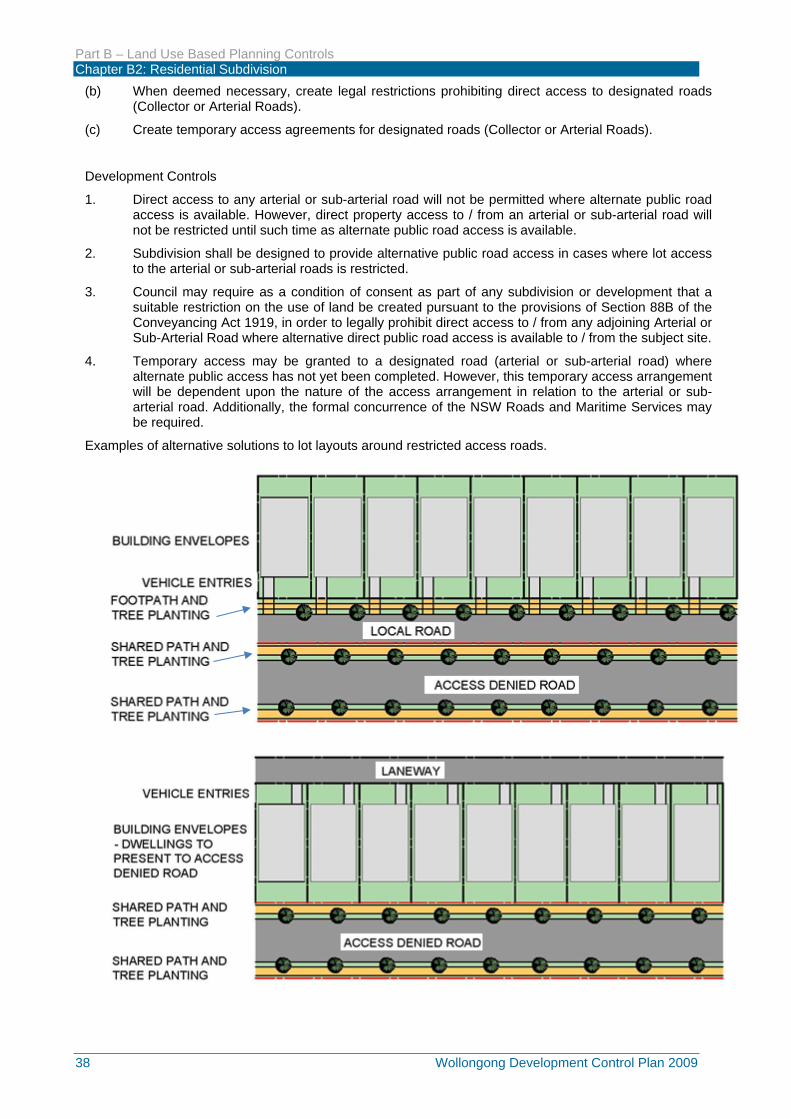
Part B – Land Use Based Planning Controls Chapter B2: Residential Subdivision
38 Wollongong Development Control Plan 2009
(b) When deemed necessary, create legal restrictions prohibiting direct access to designated roads (Collector or Arterial Roads).
(c) Create temporary access agreements for designated roads (Collector or Arterial Roads).
Development Controls
1. Direct access to any arterial or sub-arterial road will not be permitted where alternate public road access is available. However, direct property access to / from an arterial or sub-arterial road will not be restricted until such time as alternate public road access is available.
2. Subdivision shall be designed to provide alternative public road access in cases where lot access to the arterial or sub-arterial roads is restricted.
3. Council may require as a condition of consent as part of any subdivision or development that a suitable restriction on the use of land be created pursuant to the provisions of Section 88B of the Conveyancing Act 1919, in order to legally prohibit direct access to / from any adjoining Arterial or Sub-Arterial Road where alternative direct public road access is available to / from the subject site.
4. Temporary access may be granted to a designated road (arterial or sub-arterial road) where alternate public access has not yet been completed. However, this temporary access arrangement will be dependent upon the nature of the access arrangement in relation to the arterial or sub-arterial road. Additionally, the formal concurrence of the NSW Roads and Maritime Services may be required.
Examples of alternative solutions to lot layouts around restricted access roads.

Part B – Land Use Based Planning Controls Chapter B2: Residential Subdivision
Wollongong Development Control Plan 2009 39
14 BUSHFIRE PROTECTION Objectives
(a) Proposed residential subdivisions designed to minimise the potential bush fire hazard risk to prevent future loss of, and damage to life, property and the environment due to bushfires.
(b) Residential subdivision designed to minimise the siting of future dwellings away from ridge tops and other steeply sloping land, especially upslope lands, within saddles or narrow ridge crests.
(c) Proposed residential subdivisions designed to provide an efficient and safe road network which minimises potential bottle-necks.
(d) Minimise the impact of fire protection measures on vegetation, fauna, views, watercourses and soil erosion, amenity and safe access.
(e) Ensure each residential subdivision upon bush fire prone land is designed to provide satisfactory asset protection zones (APZ) between areas of potential hazard and development.
Development Controls
1. New residential subdivisions in bush fire hazard prone lands will generally require a perimeter road system to assist in providing space and access to fire fighting vehicles. Council will refer to NSW Rural Fire Service regarding compliance with specifications and requirements.
2. Any proposed residential subdivision upon land classified as bush fire prone land is an Integrated Development Application under the Environmental Planning and Assessment Act 1979. As such, formal concurrence is required from the NSW Rural Fire Service, pursuant to section 100B of the Rural Fires Act 1997.
3. Any Integrated Development Application for residential subdivision upon bush fire prone land will be subject to compliance with the requirements of NSW Rural Fire Service publication “Planning for Bush Fire Protection”. The application must be accompanied by a bush fire assessment report. The bush fire assessment report must be prepared by a suitably qualified and experienced bush fire consultant and must provide a comprehensive assessment as to how the proposed development complies with the relevant specifications and requirements.
The Statement of Environmental Effects (SEE) should specifically address the findings and conclusions of the bush fire assessment report to ensure compliance with the “Planning for Bush Fire Protection”. The findings and conclusions of the bush fire assessment report should also be reflected in the design of the proposed subdivision. Council will refer this information to NSW Rural Fire Service for assessment advice.
15 STORMWATER DRAINAGE Objectives
(a) Minimise stormwater drainage run-off impacts upon downstream properties.
(b) Limit post development discharges to pre-development levels.
(c) Provide a sustainable stormwater drainage and water quality environment incorporating both natural and man-made landscape features and which is aesthetically pleasing.
(d) To encourage water sensitive urban design initiatives for larger residential subdivisions, in order to maintain or enhance the water quality in watercourses.
Development Controls
1. A detailed stormwater drainage concept plan together with calculations is required to be submitted with the Development Application.
2. The proposed stormwater drainage system for the subdivision shall be designed in accordance with the requirements of the Stormwater Management & Water Sensitive Urban Design chapters in Part E of the DCP.
3. For subdivisions involving 20 or more allotments, the proposed stormwater drainage system must

Part B – Land Use Based Planning Controls Chapter B2: Residential Subdivision
40 Wollongong Development Control Plan 2009
incorporate water sensitive urban design techniques, wherever possible, in order to minimise runoff and restrict discharge from the site. This may be achieved by using grass swale drains, bio-filtration, bio-retention basins, detention ponds, reuse systems and retention of natural watercourses including wetlands and pool and riffle zones etc. Other stormwater quality improvement measures such as artificial wetlands, sedimentation basins and gross pollutant traps or trash racks may also be provided to facilitate the removal of sediment and other pollutants.
4. Where water sensitive urban design features (eg grass swales, bio-filtration measures, water quality detention ponds or basins etc) are proposed to be ultimately handed over to Council, upfront consultation is required to be held with Council prior to the lodgment of any subdivision application. This will ensure that appropriate design parameters, minimum performance requirements, monitoring and maintenance regimes are agreed upon between Council and the subdivider for each relevant WSUD treatment measure upfront. In the event that no agreement is reached upfront, Council is unlikely to accept the handover of any such assets.
5. All stormwater drainage systems are to be designed considering ‘living waterways’ as places for people. Some protections may be needed to prevent access to any highly hazardous features of drainage and water quality facilities.
6. The discharge of stormwater runoff must be restricted into a lawful point of discharge such as a natural watercourse or waterway to which the development site naturally drains or existing stormwater drainage systems as agreed to by Council.
7. Where there is no existing lawful point of discharge, the applicant must:
(a) Dedicate the discharge point to Council’s connecting reserves or easements that provide legal continuity from the site to an off-site legal point of discharge into a natural watercourse or waterway or suitable public stormwater drainage system and
(b) Construct the necessary connecting drainage works.
8. For sites sloping away from public roads or watercourses, written documentary evidence must be provided from downstream property owners which confirms their agreement for stormwater drainage pipes and associated creation of necessary easements through their properties, in order to guarantee that satisfactory arrangements have been made for stormwater drainage from the site.
9. The provision of inter-allotment drainage is required where drainage pipelines convey stormwater from private residential lots across other adjoining residential lots (ie not draining directly to a public road). The creation of 1.5 metre wide inter-allotment drainage easements will be required as part of the subdivision. The inter-allotment drainage easements shall not be vested in Council.
10. Where it is necessary to connect into Council’s existing stormwater drainage system, the capacity of the existing stormwater drainage system is to be checked to ensure its capacity of accepting the additional developed run-off from this development. Costs associated with any necessary upgrading or drainage is to be borne by the developer and work is to be undertaken in accordance with Council’s Subdivision Policy and Part E Stormwater Management chapter to this DCP.
16 RIPARIAN LAND MANAGEMENT Objectives
(a) Protect urban creeks and riparian corridors and their native ecology from further degradation and improve their environmental function.
(b) Maintain or enhance the stability of the bed and banks of a watercourse.
(c) Minimize ‘edge effects’ at the riparian corridor / urban interface by the provision of a suitable riparian corridor width and create borders with perimeter road systems and pedestrian/cycle paths.
(d) To ensure riparian land management measures are compatible with floodplain risk management objectives.
Development Controls
1. Any proposed residential subdivision involving waterfront land on, in or within 40 metres of the top of bank of a river, creek or intermittent watercourse, lake or estuary will be subject to compliance

Part B – Land Use Based Planning Controls Chapter B2: Residential Subdivision
Wollongong Development Control Plan 2009 41
with the requirements of Chapter E23 Riparian Corridor Management in this DCP.
2. Any riparian land within a subdivision will be subject to a Vegetation Management Plan (VMP) to assist in establishing an ongoing management process. This VMP will include ownership, maintenance and management arrangements.
17 SERVICING ARRANGEMENTS Objectives
(a) To ensure the provision of infrastructure servicing / utilities is carried out in accordance with the requirements of Council and the relevant infrastructure servicing authority.
(b) To maximise the opportunities for shared (common) trenching and to reduce constraints on landscaping within road reserve verges.
Development Controls
1. It is recommended applicants consult with servicing authorities at an early stage in the planning process to ensure that all allotments can be appropriately serviced by reticulated water and sewerage and electricity supplies as different servicing needs may require subdivision lot/layout design responses.
2. Shared common trenches for service infrastructure to be underground are preferred in order to also enable the planting of trees and other landscaping within the road verges.
3. In the event that the subdivision cannot be adequately serviced by reticulated water and sewerage supplies, then Council is unlikely to support any such application.
4. Where a subdivision is approved, a condition of consent will be imposed requiring the submission of a Notice of Requirements from Sydney Water Corporation to Council prior to the release of the Construction Certificate for the proposed subdivision. Additionally, a separate condition of consent will be imposed requiring the submission of a Section 73 certificate from Sydney Water Corporation which confirms that satisfactory arrangements have been made for reticulated water and sewerage infrastructure to the subdivision and the original Section 73 Certificate lodged with the Subdivision Certificate application.
5. Electricity distribution must be underground in all new residential subdivisions. Accordingly, the subdivision plan should provide details of the location of any required electricity sub-stations.
6. Telecommunication services are to be provided to all proposed lots. The submission of documentary evidence from a telecommunications carrier will be required for any approved subdivision, prior to the release of the Subdivision Certificate.
7. All allotments must be designed to enable the suitable provision for waste facilities. In cul-de- sacs, the head of the cul-de-sac must be designed to provide sufficient road reserve width (footpath area), in order to enable the storage of garbage and recycling bins without hindering access to adjacent properties.
8. Battle axe allotments shall be designed to include sufficient area within the existing public road reserve verge to cater for the provision of garbage and recycling bins. Alternatively, a garbage and recycling bin storage area may be provided within close proximity to the adjoining public road, but will be subject to private waste servicing arrangements being made by the property owner in the event that Council’s waste contractor is not able to service the bin storage area.
9. Applicants are encouraged to liaise with Council’s Waste Services Section of the City Works Division, in order to guarantee satisfactory waste service arrangements and to minimise potential future problems arising from poorly designed waste and recycling storage facilities.
18 ROAD ADDRESSING Objectives
(a) To ensure that addressing of property is undertaken in a consistent approach across NSW.
(b) To ensure logical and unique identification of property.

Part B – Land Use Based Planning Controls Chapter B2: Residential Subdivision
42 Wollongong Development Control Plan 2009
(c) Provide improved clarity and direction for emergency services and the community.
(d) Addressing to reflect longstanding address identification to minimise confusion and reduce disruption to the local community.
Development Controls
1. Lot numbering (assignment of address numbers) and road naming is to be undertaken in accordance with the Geographical Names Board - NSW Addressing User Manual.
2. Council has a responsibility to clearly identify public roads in accordance with the Roads Act 1993, and in the interests of public information and safety.
3. Where new roads exist the developer is to apply for a road naming application for the names of new road(s), together with the reasons for the names proposed, should be submitted in accordance with Council’s Road Naming Policy for Council’s consideration.
4. Where no suggestions are received for the naming of roads, Council will determine the street names.
5. New street name signs are to be paid for and installed by developers.
6. As part of the road naming procedures under the Roads Act 1993, Council will forward the proposed road names in a subdivision to the Geographical Names Board for the Board’s appropriate comment. In cases where the Geographic Names Board does not support the proposed road naming, Council will request alternative road names and in certain cases will liaise with the applicant.
7. For any classified roads, the NSW Roads and Maritime Services will determine the road name in consultation with the Geographic Names Board.
8. Upon receipt of development consent Council can assign address numbers. Addressing for lots will be provided from Council according to Councils Property addressing policy, prior to the issue of a construction certificate.
9. Poor or inadequate house numbering (or even no numbering at all) can seriously hamper emergency services in the performance of their duties. Street / property numbering shall be clearly and permanently displayed at the primary frontage of each lot.
19 SUBDIVISION HANDOVER Objectives
(a) Ensure that local Council assets are handed over to Council in a satisfactory condition and reflecting the assets intended design purpose.
(b) To ensure the community can suitably utilise the asset to be handed over in a safe and practical manner.
(c) To provide clear requirements, procedures and guidelines relating to the handover process.
(d) Provide information and documentation that ensure the longevity and design life of any Council asset.
Development Controls
1. Records are to be kept of the dimensions, length, square meterage and associated costs of constructed roadworks, landscaping and other civil assets intended to be dedicated as public infrastructure. CCTV is required of all pipelines to be dedicated to Council at practical completion of the development and again prior to handover of the asset.
2. Road pavement details, including survey of each layer, material used, during road construction, is to be documented. Additional geotechnical engineering testing results including pavement density and Benkelman beam results must be provided.
3. Operations and maintenance manuals for assets are to be prepared and handed over to Council. These manuals must include but not be limited to proposed type and frequency of establishment and maintenance intervention requirements. Maintenance requirements must cover civil assets

Part B – Land Use Based Planning Controls Chapter B2: Residential Subdivision
Wollongong Development Control Plan 2009 43
(including and not limited to gross pollutant traps, detention basins, water sensitive urban design assets), landscape assets (including and not limited to street trees, reserves, parks, playgrounds), and riparian areas (such as creeks, bushland), and areas covered by vegetation management plans.
4. Risk assessment of carrying out maintenance of constructed roadworks, landscaping and other civil assets to be dedicated as public infrastructure is to be undertaken. Appropriate traffic control plans (prepared in accordance with RMS Guidelines) will need to be submitted for approval where maintenance work takes place in a proposed road reserve.
5. All relevant reports / documentation (e.g. surveillance reports, emergency management plans etc.) associated with any detention storage basin/s, as required by the NSW Dam Safety Committee (DSC) are to be provided, including documentary evidence confirming approval of this reporting/documentation by the DSC.
6. A final inspection is required at the conclusion of the defects liability period outlined in the development consent, for each component/asset to be handed over to Council. This meeting will be undertaken with relevant Council staff to ensure that the assets are in a satisfactory condition for handover to Council. The inspection is a review of works that have received practical completion against the approved drawings/development consent after the defects liability period has ended.