chapter growth capacity
TRANSCRIPT

Ponca City, Oklahoma Comprehensive Plan 3.1
GrowthCapacity
INTRODUCTION
The expectations of citizens coupled with the desire of City staff to deliver high-quality services necessitates thoughtful planning to ensure municipal services are maintained at the highest possible level. The complexity of the municipal service delivery system requires a highly integrated and strategic approach to service delivery planning. Significant consideration must also be given to ensure citizen and customer access to all desired services. Attention must also be given to the cost of services – for ongoing provision and future expansion – so that municipal services are both cost effective to deliver and affordable to citizens.
This chapter also addresses community facilities, which are a significant City responsibility and a major component of Ponca City’s physical, social, and economic fabrics. Such facilities help define the identity of the community and contribute to its social and economic prosperity. Population growth and geographic expansion represent future challenges to the City. More importantly, adequate attention must be given to the expansion, maintenance, and modernization of existing facilities. Facilities often involve major capital investments and time.
Ponca City seeks growth on terms that residents fi nd desirable and benefi cial. This chapter evaluates anticipated growth and its near- and long-term impacts on the community. Based upon the analyses conducted during the plan development process, it is anticipated that the community will grow from a 2000 Census population of 25,919 persons to a projected Year 2030 population of approximately 28,090 persons. Therefore, this chapter contemplates the requisite land consumption and the necessary facilities and infrastructure to accommodate this growth.
CHAPTER
3
Affordability must be balanced with community needs. As such, new facilities must be prioritized in terms of strategic importance to the community to address current and future growth needs.
PURPOSE
The purpose of this chapter is to establish the City’s intent and its policies for managing future growth and development in an orderly and fiscally responsible manner. This involves many important fiscal and community considerations. Chief among them is the capacity of utility infrastructure and public service provision, as well as the efficient use of land and the existing road network. Furthermore, it also involves future planning for adequate provision of parks and recreation facilities and public safety services, as well as the generation and distribution of electricity, waste collection and disposal, and technology (fiber optic and wireless) infrastructure.
Given the City’s role in providing facilities and services, the following are addressed in this chapter:
The availability, quality, type, size, and location ♦of recreation opportunities to meet the needs of Ponca City residents and visitors.

Growth Capacity
CHAPTER
3
3.2
The distribution and capacity in water and ♦wastewater facilities, both now and in the long-term future. The drainage situation resulting from the natural tributary conditions and increased development.
The ability to provide adequate public ♦safety services to the current geographic area while preparing for the added service demands that will come with increased development and more population.
The City’s central role in the generation ♦and distribution of electricity within the City, but perhaps more importantly, to the areas outside of the City limits where other infrastructure is not available or appropriate.
Consideration of waste collection as it ♦relates to the City’s service area and the efficiency of operations.
Provision of technology infrastructure ♦including fiber optics and wireless Internet communication.
In addition to the essential planning considerations and guidance related to the City’s infrastructure and public service provision, this chapter also establishes an overall framework for managing future growth. This includes strategic directions as to changes in policy and practices that should be considered to better manage future growth and development. The emphasis is on viable and practical solutions for the City to pursue as a means to preserve its “small town” character, ensure efficient provision of adequate infrastructure and services, protect its strategic community assets, and secure the community’s long-term fiscal health.
This chapter is divided into four sections of issues and recommendations including:
Parks and Recreation ♦
Water, Wastewater, and Drainage ♦
Public Safety and Utility Services ♦
Growth Management ♦
These are further divided into:
Existing conditions summary; ♦
Existing growth capacity analysis and ♦discussion; and
Recommended goals and actions for ♦growth capacity issues within Ponca City.
ISSUES AND RECOMMENDATIONS
Through the comprehensive planning process, Ponca City’s citizens identified various issues regarding utility availability, public service coverage, growth pressures, infill and
Parks and recreation facilities are an essential part of a healthy and quality community environment. They provide the necessary components for events outside of the home, aft er work, and aft er school. Whether for passive or active use, parks and recreation facilities are an important part of everyday active living. Much like streets and sidewalks, water and wastewater lines, drainage facilities, police and fi re equipment, and other municipal facilities and services, parks are an integral component of the municipal infrastructure. Therefore, they warrant a signifi cant level of att ention and commitment of resources.
Source: 2008 - 2009 Annual Budget

Ponca City, Oklahoma Comprehensive Plan 3.3
redevelopment potential, and preservation of rural character and resources as the City’s outward growth continues. The overarching issue areas highlighted in this section, along with the key planning considerations under each, informed the development of the summaries and recommendations that follow.
PARKS AND RECREATION
Existing Conditions Summary
Ponca City has a large amount of acreage and a relatively well-distributed array of parks and recreational facilities. However, while the quantity and locations of parks are generally adequate, there remain opportunities for enhancing their quality. In terms of their quality, it is not the level of care and maintenance, but a potential for upgrading existing facilities and improving their accessibility and appearance. The level of need is noted in the capital budget and by way of statements integrated in Vision 2020 – The Dawning of a New Day. Through the evaluation of the City’s park system, there are
also several fairly sizeable gaps in the service areas of neighborhood parks. This means that the existing facilities are not within convenient proximity to all neighborhoods, thereby limiting their access and utilization. This offers an opportunity for added parks or improved connectivity. A comprehensive system of parks that responds to the needs and values of local residents contributes to quality of life and livability. Parks and recreation opportunities also contribute to the health of residents, provide a variety of recreational and educational activities for all ages, and preserve the integrity of the natural environment. They are also important in attracting visitors to the community and, thus, contribute to local tourism and economic development.
Facts and Figures
The location of Ponca City parks and other recreation areas and facilities is displayed in Map 3.1, Parks & Recreation. A summary listing of the facilities within the City limits is
FACILITY NAME TYPE ACREAGE FACILITY NAME TYPE ACREAGEPonca Lake Recreation Area 1,160.69 Johnson Community Park 8.22
Ponca City Country Club Golf Course Recreation Area 154.21 Brentwood Community Park 7.17
GOOF's Air Field Community Park 127.82 Lake Ponca Campground Recreation Area 7.17Lew Wentz Golf Course Recreation Area 120.81 Johnson Community Park 5.64Pageant Area Community Park 57.58 Sherwood Neighborhood Park 5.49Standing Bear Park Recreation Area 47.38 Sunset Neighborhood Park 5.36Lake Checkstand Recreation Area 42.63 Young Neighborhood Park 4.46Jack Blevin MotoCross Track Community Park 41.67 Ranchwood Neighborhood Park 3.73Crammers Community Park 40.41 Crown Neighborhood Park 3.52Lake Ponca Nature Center Recreation Facility 33.07 Academy Neighborhood Park 3.39Marland Mansion Estate Recreation Facility 30.07 Marland Grand Home Recreation Facility 3.25Lake Ponca Park Community Park 26.55 Jaycee Community Park 3.22Willow Springs Community Park 25.51 Brentwood Community Park 3.17Dan Moran Community Park 24.89 Attucks Neighborhood Park 3.14Boy Scout Camp Community Park 24.71 Unity Gym Recreation Facility 2.87Lew Wentz Camp & Pool Recreation Area 23.55 Hobo Neighborhood Park 2.36Archery Range Community Park 21.67 AMBUC Community Park 2.26War Memorial Park and Trail Community Park 21.41 Pecan Community Park 2.23Donner Recreation Area 15.26 Briar Ridge Neighborhood Park 2.18
Ponca City Aquatic Family Center Community Park 15.04 Hutchins Memorial Community Park 2.13
Liberty Neighborhood Park 13.91 Wally Smith Tennis Center Recreation Facility 1.41Mertz Field Recreation Area 12.66 Edgewood Neighborhood Park 1.06Pioneer Woman Statue & Museum Recreation Facility 11.66 McGraw Neighborhood Park 0.92L.A. Cann Memorial Garden Recreation Area 9.76 Brentwood Community Park 0.73
Redbud Neighborhood Park 9.25 Lake Ponca Enclosed Fishing Dock Recreation Area 0.44
Ranchwood Neighborhood Park 8.75 Ambuc Outdoor Swimming Pool Recreation Facility 0.43Pioneer Community Park 8.42 McFadden Recreation Facility 0.27Garfield Neighborhood Park 8.31 Big Springs Neighborhood Park 0.17
TOTAL 2,223.89
Table 3.1: Existing Park Facilities

Growth Capacity
CHAPTER
3
3.4
NEEDS ASSESSMENT
Resources versus Needs
A standard-based approach was used to assess the need for additional parks and recreation areas and facilities within Ponca City. Using the published standards of the National Rec-reation and Park Association (NRPA), the acreages of parks and recreation areas currently recommended for Ponca City are as displayed in Table 3.2, Park Needs Assessment. The potential need for additional parks and recreation acreage to satisfy current demands is determined by applying the recommended standards to the current population of the City.
As shown in Table 3.2, based on a 2000 population of 25,919 persons, Ponca City should have a total of 26 acres of Neighborhood Parks and 130 acres of Community Parks based on the NRPA standard. Ponca City has a total of 76 acres of Neighborhood Park and 471 acres of Community Park, altogether totaling 547 acres. Therefore, based on the park acreage available to the community today, the City has a surplus of roughly 391 acres in its amount of public parkland. The current and future challenge for the City is that various parks in its current inventory are in need of signifi cant maintenance.
Also displayed by Table 3.2 is a tabulation of the recommended park acreage necessary to support the projected 2030 population of 28,090 persons. According to NRPA standards, Ponca City is currently suffi cient in both park categories. Ponca City needs 28 acres of neighborhood parks and 140 acres of community parks to support the projected population; in which the City currently has a total surplus of 379 acres.
Service Area Coverage
Depicted in Map 3.2, Park Service Areas, are service area buff ers around all existing parks, recreation areas, and facilities, with a varying buff er radius depending upon the park clas-sifi cation. In the case of each community park (i.e. Crammers Park), a neighborhood park service area illustrates how the park also functions as a local park resource for the immedi-ate area. From a purely locational standpoint, preliminary analysis indicates that much of northeastern Ponca City has convenient access to City parks. However, park coverage is lacking in portions of west and north-central Ponca City.
Table 3.2: Park Needs Assessment
SESSMENT
sus Needs
ed approacach h wawas s ususeded t to o asassesessss t thehe n neeeed d d fofor r adaddidititiononalal p para ks and recties witithihin n PoPoncnca a CiCityty. . U Usisingng t thehe p pubublilishsheded s statandndarardsds o of f tht e Nationrk Assocociaiatitionon ( (NRNRPAPA),), t thehe a acrcreaeageges s ofof p pararksks a andnd r rececrereatatioionn arareae s cuor Poncnca a CiCityty a arere a as s didispsplalayeyed d inin TaTablble e 3.3.2,2, P Parark k NeNeededs s AsAssesessmefor addittioionanal l paparkrks anndd reecrcreaeationon a acrcreaeagege t to o sasatitisfsfy y cucurrrrenent t dedemmandapplyingng thehe rececomommemendnded statandndardsds tto tht e cucurrrenentt popopulalatitionon of th
able 3.2, based on a 2000 popupulalatitionon oof f 2525,9,9191 persons, Ponca City s26 acres of Neighborhood Parks and 130 acres of Community Parks bdard. Ponca City has a total of 76 acres of Neighborhood Park and 4Park, altogether totaling 547 acres. Therefore, based on the park acrcommunity today, the City has a surplus of roughly 391 acres in itsnd. The current and future challenge for the City is that various par
ory are in need of signifi cant maintenance.
Park Needs Assessment
Neighborhood Park 1 76 26 50 28 48Community Park 5 471 129 342 140 331
547 155 392 168 379
Based on a 2000 census population of 25,919Based on a projected population of 28,090 by the Oklahoma State Data Center
TOTAL
2030
Required RequiredClassification
Standard (acres per
1,000 persons)
Existing Acreage
2000
Surplus/ Deficient
Surplus/ Deficient

Ponca City, Oklahoma Comprehensive Plan 3.5
provided in Table 3.1, Existing Park Facilities. The City currently offers an assortment of parks that provide opportunities for a typical variety of activities. The community currently has access to an inventory of 56 parks and recreation areas, representing a total of 2,224 acres of land. The acreage is divided into:
21 community parks offering 470 acres; ♦
15 neighborhood parks totaling 76 acres; ♦
11 recreational areas totaling 1,595 acres; ♦and
Eight recreational facilities contributing ♦an additional 83 acres to the City’s park inventory.
The City’s parks and recreation system is, in many ways, unique; notably:
The Ponca City Parks and Recreation 1. Department owns and maintains 56 parks and recreation areas and facilities ranging from neighborhood and community parks to lakes and historic properties and museums.
Ponca City has a much greater ratio of 2. community parks, equaling 21 acres per 1,000 persons versus the National Recreation and Park Association (NRPA) recommended minimum of five acres per 1,000 persons. This is primarily due to the inclusion of sizeable community park facilities including GOOF’s Air Field (127.82 acres), Jack Blevin MotoCross Track (41.67 acres), and Lake Ponca Park (26.55 acres), together with several recreational areas.
The many historic places and memorials 3. contribute to the inventory of recreational areas and facilities. These facilities represent cultural, open space, and economic development opportunities.
The City’s Trails Master Plan (1999) has 4. facilitated the emergence of a trails system, which, in time, will help make linear connections between the City’s parks, schools, and neighborhoods.
The foundation for establishing an adequate parks and recreation system begins with the availability, location, and condition of the existing City-located parks and recreation areas. In determining the need for additional parkland, recreational facilities, and park-related improvements, the first step is to assess the level of sufficiency of the existing parks in meeting the needs of the community. Each park must also be evaluated in terms of its proximity to its users, its safety and accessibility, the availability and condition of its equipment and facilities, and its utilization.
Analysis of the Parks Plan: Convenient and Accessible Parks
A key to a well-utilized system of parks is an even distribution of recreation areas and public open spaces throughout the community. In this way, all residents have convenient access to public open spaces and facilities, thereby meeting their active and passive recreation needs. Ponca City’s large quantity of dispersed parks provides a convenient and moderately accessible system. It may benefit, though, through modifications to further improve the convenience and accessibility of parks. As reflected on Map 3.2,
The amount of community green space is greatly complimented by Lake Ponca, Kaw Lake, and the
many associated water activities that make the area popular as a place to live and a weekend destination
for area residents.

Growth Capacity
CHAPTER
3
3.6
desire more passive activities like nature trails and picnic areas. For this reason, it is essential to include neighbors in the planning and design phases of park development.
A true “system” of parks offers a wide range of public spaces, including sizable facilities that may be used by the whole community, like Standing Bear Park and Crammers Park; parks that are intended for use mainly by residents of nearby neighborhoods, such as Big Springs Park and McGraw Park; and those recreational sites used by an individual development, such as a play area within an apartment complex. The value of an adequate park system is in its ability to meet the individual, diverse needs of all persons.
Recommendations
Develop an even distribution of parks 1. and recreation facilities throughout the community. Particularly, seek to acquire land and develop parks within the identified neighborhood park “need areas.”
Expand upon the range of facilities and 2. improvements available to include those that may provide an added attraction per the preferences of community residents.
Improve the accessibility for disabled and 3. handicapped users including sidewalk curb cuts and ramps, wheelchair-accessible sidewalks and trails, and accessible facilities such as play equipment, drinking fountains, and restrooms.
Parks Plan Analysis: Quality Park Appearance and Maintenance
Although there is a sufficient amount of park space, the condition and appearance of facilities is essential. This is because parks are an indicator of community priorities and, hence, quality of life. Therefore, parks that appear “tired” convey an impression as to the community’s value and appreciation for its public spaces, which contributes significantly to both livability
Park Service Areas, there are several “need areas” for which additional space is preferable. Several of these need areas are in existing neighborhoods with dense populations. These areas pose a challenge in siting a new park, but also hold the most potential in providing a service to existing residents. The construction of the Ponca City Aquatic and Family Center is an example of additional park service area coverage on the west side of the City.
It is important that each park is appropriately located and designed to be compatible with the adjacent and surrounding neighborhoods. Depending on the make-up of the population and the availability of other nearby facilities, some neighborhoods may be more interested in active play areas, such as basketball and tennis courts and open play fields, while others may
Park System Plan - Distribution
Ponca City residents and community leaders understand and appreciate the important role that parks, open spaces, and other recreation opportunities play in quality of life, tourism, and marketability of the community. The future of parks and recreation should be one of vision, excellence, inclusion, and balance.
Several existing neighborhoods and some of the developing neighborhoods do not have a park in near proximity. Therefore, while there is an abundance of community parks covering the limits of the community, there are areas that are defi cient in neighborhood parks.

Ponca City, Oklahoma Comprehensive Plan 3.7
and community identity. In fact, studies have shown that quality parks increase adjacent property values and are a consideration in home shopping and purchase decisions. Collectively, parks and public open space areas also contribute to the aesthetics and natural beauty of the community.
The idea of a “parks inventory and maintenance” program is to set a standard by which all parks, recreation areas, and public spaces are measured. A program of improvements may then be established to bring each park to an equivalent standard – adhered to through an ongoing maintenance commitment. In this way, the entire park system is elevated in quality and level of importance. This may be accomplished through both public and private efforts.
Since the community has a substantial inventory of park acreage, the priority should be to maximize the potential of each park by providing for increased maintenance and enhancement. Each park should be brought to an equivalent high improvement standard through increased maintenance, upgrades, and improvements. For instance, there are opportunities to integrate interpretive education into the parks to expound upon the City’s historical roots, cultural offerings, and recreational tourism. This will require a commitment to provide the necessary funds
to “catch up” on current deficiencies while also preparing for future needs. As all improvements are not needed at once, it is advisable for the community to establish immediate, mid-term, and long-range priorities.
The City may increase their annual funding for both operating and capital
expenditures to include new or replaced equipment, building rehabilitation, and
increased maintenance. The private sector and individual residents and groups may provide in-kind services, volunteer labor
(such as an “adopt-a-park” program), and/or dedicate land or contribute fees
in-lieu of land concurrent with new development.
Source: 2008 - 2009 Annual Budget

Growth Capacity
CHAPTER
3
3.8
Recommendations
Support and carry out an aggressive park 1. and facility maintenance program, which must be acted upon continuously. The program must identify and log all necessary maintenance items, including repair of broken equipment, identification of unsafe conditions and remedies for correction, and items warranting significant capital expenditures.
Create a Parks and Recreation Master 2. Plan that formally inventories all parks and recreational lands and facilities. This plan
would guide long-term park improvements and address the issues related to maintenance and upkeep. A key issue to be addressed by the plan is the amount of staff time required to perform maintenance on existing properties and their responsibilities for assisting with special events.
Explore formal arrangements/agreements 3. with individual user groups that include in-kind services and possible user fees. These services or fees may help to offset the costs of specific improvements, such as field lighting, new play equipment, viewing stands, and benches. This collaborative effort would begin by documenting recreational demands and specific needs, followed by a multi-year improvement program that is based on the level of utilization.
Intensify efforts to incorporate cultural, 4. historical, environmental, and other educational activities into parks, open spaces, and trails. This may include displays, performances, exhibits, and/or markers.
Aggressively implement best land 5. management practices in park improvements and maintenance, specifically for purposes of environmental protection and management, as well as interactive education opportunities and overall beautification efforts.
Parks Plan Analysis: Continue with Efforts Set Forth by the Trails Master Plan
Implementation of the Trails Master Plan (1999) will embrace the potential of the parks system by improving access within and between parks, school, and neighborhoods. This will make the parks available to an increased number of users. If designed appropriately, each of the trails may also provide opportunities for expanding the community’s cultural, historic, or tourism programs. For instance, segments of the trail system may be designed as routes along historical walking tours, while others may serve as natural areas or linear parks, as expressed in the Trails Master Plan.
Perhaps the most important aspect of trails is their usefulness in creating convenient and safe connections between neighborhoods and destinations throughout the community without the need for a car. To do so, there must be a mixture of trails, sidewalks, and bike lanes or routes that seamlessly tie the community together.

Ponca City, Oklahoma Comprehensive Plan 3.9
Success of a comprehensive bike and pedestrian network will depend upon the ability to create a system that is equally reliable and more safe, convenient, enjoyable and accessible than making the same trip by car. The network must, therefore, be well marked and in excellent condition with amenities such as good wayfinding signage, adequate lighting, safe crosswalks, interesting view and attractions, and creation of a unique experience. Recommendations
Incorporate into the City’s development 1. standards provisions for the protection of resources. The resource area may then be dedicated to the community as permanent passive open space or as active recreation space, such as trails and greenways. A density bonus may act as an incentive to the developer by allowing an increase in the overall development yield in exchange for preserving open space.
Amend the subdivision regulations to require 2. pedestrian easements in appropriate mid-block locations to allow direct and convenient access to existing or planned parks and trails.
Consider the use of trails and strategically 3. selected sidewalks as educational, informational, and aesthetic resources, particularly along paths that connect tourism destinations.
Utilize pervious materials for the bike and 4. pedestrian networks, which softens the walking surface and is more environmentally friendly.
Incorporate branded amenities along the 5. network as a means of identification and user way-finding, possibly including informational signs, kiosks/directories, pedestrian-scale lighting, rest areas with benches and water fountains, bike racks, and educational markers.
WATER, WASTEWATER, AND DRAINAGE
Existing Conditions Summary
The role of water and wastewater is central to Ponca City’s ability to grow and develop over time. There are also public policy arguments for fiscal responsibility in extending water and wastewater connections. In both respects, Ponca City is pursuing positive end goals: Investing in system maintenance while adhering to a policy of expansion only through annexation. Changes in water and wastewater service areas will not be a significant growth factor as nearly all areas of the community are already served by City water and wastewater. The surrounding areas are served by rural water districts and septic tanks. With a few exceptions, the City’s systems have been and will continue to be optimized to accommodate service requirements based on the locations of current and anticipated development and City boundaries.
The above policy must continue to be adhered to as the community prepares to accommodate 2,171 additional residents over the course of the next two decades. It is a policy of this plan that new development should occur on infill properties and in areas immediately contiguous to the City limits. This will help to ensure efficient provision of public facilities and services and a
Amenities can serve utilitarian purposes, such as signage or benches.

Growth Capacity
CHAPTER
3
3.10
logical and sequential pattern of growth. To the credit of the City and its advanced planning, its water and wastewater treatment facilities are adequately sized to accommodate this growth. Attention must continue to focus on the community’s long-term water supply, as well as the provision of water supply mains, sewers, and lift stations in the defined areas of future development. Moreover, there will continue to be perennial needs to perform maintenance on the existing system and conform to ever stringent environmental performance regulations.The need for stormwater and flood control is due to major storm events that send water into the low-lying areas of the Bois D’ Arc Creek and Arkansas River watersheds. Existing structures in the floodplain are susceptible to damage, as well as neighborhood areas near frequently flooding culverts and bridges. Further, improvements to existing drainage features will need to continue
so that local flood events are minimized. Sensitive areas within the floodplain and wetlands may be incorporated in developments as an amenity, while sustaining their resource function. Doing so requires a regulatory system that balances development efficiency and resource protection. Innovative land planning practices will preserve resources and effectively integrate them into development without compromising private interests.
Water & Wastewater Master Plan Updates
The current Sanitary Sewer and Water Supply Master Plans were previously updated in 2003 and 2006, respectively. The Water Supply Master Plan was prompted by an uncertainty of long-term water supply and the possible loss of water rights on Kaw Lake. A fresh look was also needed to assess future service demands and supply options. Recommended improvements in the water supply plan are shown as alternatives that each have separate costs and benefits. The Sanitary Sewer Master Plan analyzed the sewage collection system’s projected average daily flow compared to the ability of the wastewater treatment plant to handle existing and projected flow levels. Both master plans are intended to provide guidance in the development of water and wastewater infrastructure improvements so that the service area population and other wholesale customers will be adequately served in coming years – with a long-range planning outlook.
Water System Facts & Figures
The City has access to three raw water 1. supplies: two stream sources subject to “use it or lose it” provisions through water rights purchases (Lake Ponca and Kaw Lake) and one guaranteed groundwater right (wells).
Ponca City holds groundwater rights for the 2. use of its 55 (15 operating) wells to annually remove 14,408.6 acre-feet of groundwater. This amount is equal to the dependable yield for this source. Currently, the groundwater pumped through the well system accounts
The master plan updates employ a planning area that roughly follows the current City limits, encompassing areas that can reasonably be provided with water and wastewater services. Current and future service demands and facility needs within the planning area were determined based upon an average annual increase in water supply (one percent per year through 2055) and a build-out population of 28,090 persons (Year 2030) for wastewater capacity.
Source: Water Supply Master Plan (2006)

Ponca City, Oklahoma Comprehensive Plan 3.11
Treated water for the water system is 6. supplied by a lime-softening water treatment plant. The source for the water system is the combination of Lake Ponca and groundwater accessed through wells.
The water treatment plant has sufficient 7. capacity (up to 16 million gallons per day [MGD]) to treat the projected increased in water supply (Year 2055 average daily demand is projected to be 11.7 MGD), but improvements will be needed to meet environmental standards.
Wastewater System Facts & Figures
The Wastewater Treatment Plant averages 1. 4.42 MGD usage and is the sole plant for the City. There are 180 miles of wastewater pipes in the collection system.
The existing wastewater collection system 2. has several lift stations in need of repair (including, among others, Briar Ridge, Smith, and Brentwood). These are small facilities that pump wastewater to increase flow rates or to overcome topography in particular areas. These stations can become problematic for maintenance and also detract from system efficiency. It is, therefore, advisable to minimize the use of lift stations in new developments.
As in every wastewater collection system 3. with significant portions that were installed decades ago, flows within the piping system are increased by the infiltration of water through manhole covers, broken pipes, and faulty pipe joints (particularly at house connections), and especially during wet weather conditions. The phenomenon magnifies the flows entering treatment facilities and can lead to overflows at lift stations, among other system impacts.
The current 9.5 MGD design capacity of the 4. wastewater treatment plant is anticipated to be adequate capacity through the Year 2030. It is noteworthy that the wastewater treatment plant has been operating an
for 80 percent of the water supply. Two new wells are planned in the near term to assist in extracting groundwater supplies.
Lake Ponca water is available only to Ponca 3. City through a vested water right of 2,520 acre-feet. As an overall source of water, it currently constitutes 20 percent of the City’s water supply on an annual basis. However, the risk of siltation threatens the long-term future of Lake Ponca as a water source. Furthermore, it is unreliable as a permanent water source during periods of drought as it is highly influenced by temporal precipitation. For this reason, the water supply master plan does not include Lake Ponca in the long-term analysis.
The City acts as a wholesale supplier 4. through contracts with rural water district providers. Also, it should be noted that Oklahoma law prohibits charging the rural water district consumers a rate that includes the cost of the physical plant, depreciation, and operation/maintenance of the water system.
Kaw Lake represents a potential future 5. source of water. Ponca City has the right to use 14,031 acre-feet of water. However, practicable use of this water is only possible through a few additional conditions:
Arrangement of a storage contract with a. the Corps of Engineers.
Construction of a new pipeline to b. transmit water to the water treatment plant.
Water use is based on a “use it or lose it” c. timeline. Ponca City must “use or lose” its Kaw Lake water allocation according to the following schedule:
20% “use or lose” by 2014• 40% “use or lose” by 2029• 60% “use or lose” by 2044• 80% “use or lose” by 2059• 100% “use or lose” by 2074•

Growth Capacity
CHAPTER
3
3.12
Industrial Pretreatment Program since 1984. This program scientifically allocates the industrial waste streams to the treatment process to prevent any industrial waste stream from interfering with the plant operation.
Bois D’ Arc Creek and Arkansas River Tributaries Stormwater Master Plan
The City is split between the Bois D‘ Arc Creek and Arkansas River watersheds, which drain generally from northwest to south. Kaw Lake acts as a flood control lake at Mile 653 of the Arkansas
River. While this reservoir has acted to stem most of the flooding on the Arkansas River, it has also demonstrated that it is not certain to function effectively. In the past, frequent flooding events on the Arkansas River are lessened, but the occasional flood event does occur when there is significant rainfall in a short period of time. This flooding of the Arkansas River not only poses a threat to existing property, but also serves as a growth constraint to further expansion towards Osage County. Likewise, the low-lying areas of the Bois D’ Arc Creek watershed are prone to flooding with heavy thunderstorms. Street flooding is common during these events, in addition to instances of more serious damage to property and utility infrastructure.
The City currently regulates development in accordance with the Arkansas River Tributaries Master Plan (October 2006) and the Bois D’ Arc Tributaries Master Plan (June 2005), as well as stormwater regulations enforced by the Public Works Department. These documents provide guidance and regulatory policies for a variety of stormwater issues from large-scale floodplain management studies to detailed design of underground storm drainage systems. The City has been a continual participant in the National Flood Insurance Program (NFIP) since 1980. A stormwater utility fee ($1.00 per residential unit) directs funds towards pollutant prevention and stormwater education. This fee is a step towards addressing the newer National Pollutant Discharge Elimination System (NPDES) Phase II requirements, an unfunded mandate.
Recommendations
Implement phased improvements to the 1. water treatment plant to keep pace with projected upgrading of environmental regulations.
Complete improvements to where multiple 2. feed points will distribute water into the City from the treatment plant to avoid the risk of interrupted water service in areas where a single transmission main currently feeds a portion of the system.
Water pollution degrades surface waters making them unsafe for drinking, fi shing, swimming, and other activities. As authorized by the Clean Water Act, the National Pollutant Discharge Elimination System (NPDES) permit program controls water pollution by regulating point sources that discharge pollutants into waters of the United States. Point sources are discrete conveyances such as pipes or man-made ditches. Individual homes that are connected to a municipal system, use a septic system, or do not have a surface discharge do not need an NPDES permit; however, industrial, municipal, and other facilities must obtain permits if their discharges go directly to surface waters. In most cases, the NPDES permit program is administered by authorized states. Since its introduction in 1972, the NPDES permit program is responsible for signifi cant improvements to our Nation’s water quality.

Ponca City, Oklahoma Comprehensive Plan 3.13
Complete phased high service pumps and 3. water storage improvements, as itemized in the most recent Capital Budget and Water Distribution Master Plan (2005), to ensure that existing demands can be better met by the distribution system. This will be especially true as growth and development continues within particular pressure planes (i.e. east end of Lake Road).
Implement the menu of projects itemized 4. in the capital budget to address various maintenance issues at the existing water and wastewater plants. Also included in the budget are projects to replace deteriorating older lines in the water and wastewater collection system (i.e. upgrading every other line in the downtown from 4” to 8”).
Complete wastewater system improvements 5. that will allow for various lift stations to be
upgraded or eliminated from the collection system.
Investment in the water supply system is 6. recommended according to the itemized list of improvements listed in the Water Distribution System Master Plan (2005). Additional capacity in Ponca City’s water facilities, such as pumps, tanks, and treatment plants, are not expected to be required based on the projected growth. However, the facility capacities should be reassessed if Ponca City expands its service area or if growth significantly outpaces the current projections.
Involve citizens and local community groups 7. in the creation of awareness programs (NPDES Phase II requirement) designed to reduce water consumption and waste, including relatively easy and low-cost measures such
Most of the drainage in the developed areas is split between the Bois D’ Arc Creek and Arkansas River watersheds.

Growth Capacity
CHAPTER
3
3.14
as residential water catchment (from roof drainage) or water-efficient fixtures.
Construct new interceptors (such as the 8. planned interceptor from Lake Road to Hartford Road), as a transfer improvement that will benefit the overall wastewater system.
Seek to reduce infiltration and inflow with 9. capital improvements, such as pipeline rehabilitation, manhole cover replacement, and overall system analysis. Also, conduct a public education program, offer incentives, and regulate inflow sources on private property, such as broken service lines, uncapped cleanouts, and exterior drains.
Include the use of bio-swales and permanent 10. water features for drainage management to reduce the volume and rate of stormwater runoff from new developments. Stormwater carries nonpoint source pollutants into streams and lakes. Additionally, higher runoff velocities contribute to stream bank erosion, which further impacts water quality and flooding risk due to stream sedimentation.
Support green roofs on new developments 11. as a method of stormwater mitigation, as well as reduction of the urban “heat island” effect. Green roofs are important because they fundamentally change the impact of buildings. Green roofs are more expensive than regular construction; however, they provide additional insulation, which reduces energy costs for heating and air conditioning. For new construction, the use of green roofs should result in a reduction in the extent of stormwater facilities that need to be constructed to meet standards. Also, despite the higher upfront costs, green roofs typically have longer life spans than traditional asphalt shingle rooftops (30 to 40 years versus 15 years).
PUBLIC SAFETY AND UTILITIES SERVICES
Existing Conditions Summary
The expected 2,171 additional residents projected over the next two decades will place additional demands on the City’s police, fire, and emergency response services. Therefore, in order to maintain an equivalent service standard, additional resources will be necessary. This will include more police officers, firefighters, emergency responders, and the corresponding administrative personnel, space, equipment, and facilities.
Police Protection Services
A national standard used by the International Association of Chiefs of Police and other agencies when calculating needs for police is 1.8 officers for every 1,000 population. Currently, the Ponca City Police Department maintains a ratio of 2.1 officers per 1,000 residents. Based on the current population and a higher local standard, the City will want to maintain a similar ratio of officers to population. There are presently 55 officers, meaning that as population growth continues, more officers are needed. It is important to note, though, that the national standard is for benchmarking purposes and is not a definitive standard per se. For this reason, it should not replace local judgment, but simply be used as a national measuring stick. Using the City’s current standard, an additional four officers will be needed by 2030 to provide protection for the additional residents. It is understood that the existing buildings are planned for redevelopment and, once complete, the Police and Court Facility and other existing capital facilities will be adequate to meet the expected growth. However, the existing conditions of the Public Safety Center are in dire need of improvement in the near future.
Fire and Emergency Response
Recently, the City’s emergency response services have been challenged by an increase in ambulance service calls. This has placed
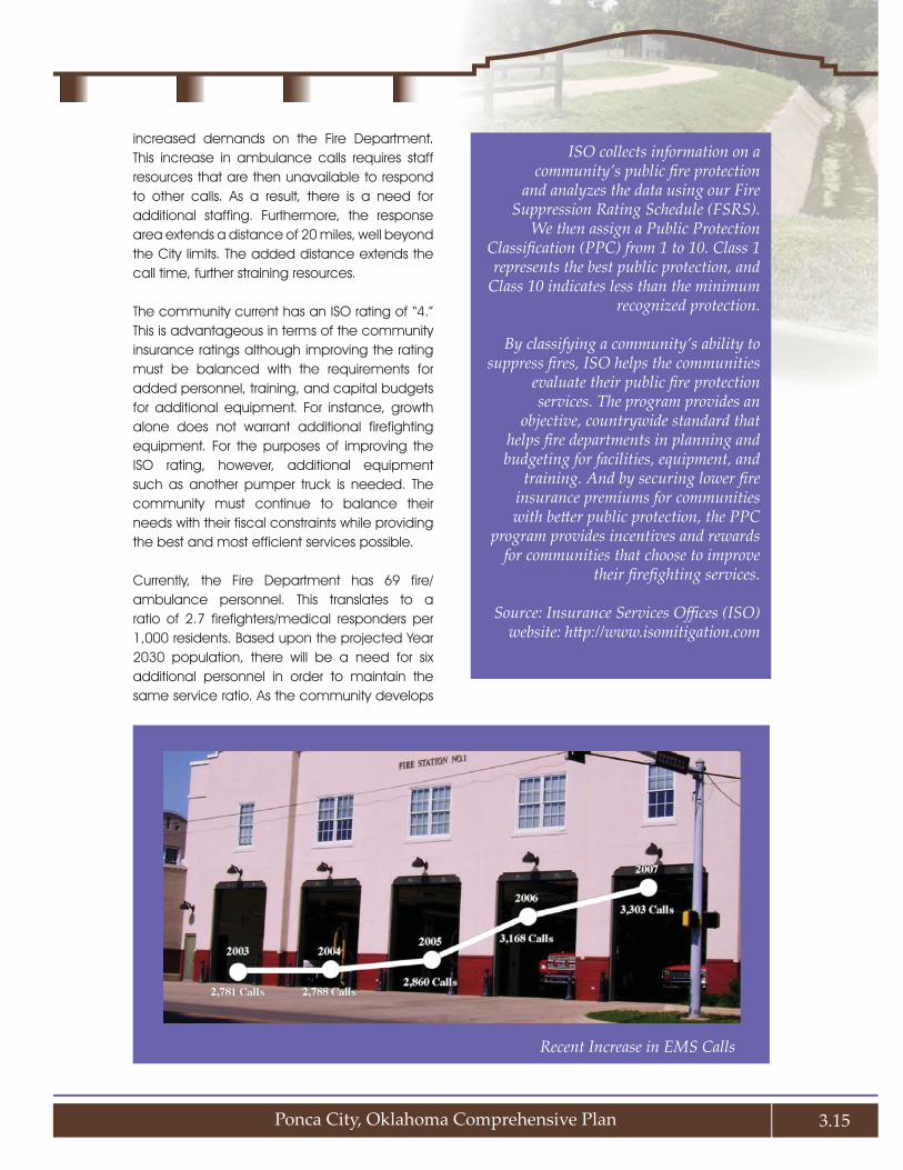
Ponca City, Oklahoma Comprehensive Plan 3.15
increased demands on the Fire Department. This increase in ambulance calls requires staff resources that are then unavailable to respond to other calls. As a result, there is a need for additional staffing. Furthermore, the response area extends a distance of 20 miles, well beyond the City limits. The added distance extends the call time, further straining resources.
The community current has an ISO rating of “4.” This is advantageous in terms of the community insurance ratings although improving the rating must be balanced with the requirements for added personnel, training, and capital budgets for additional equipment. For instance, growth alone does not warrant additional firefighting equipment. For the purposes of improving the ISO rating, however, additional equipment such as another pumper truck is needed. The community must continue to balance their needs with their fiscal constraints while providing the best and most efficient services possible.
Currently, the Fire Department has 69 fire/ambulance personnel. This translates to a ratio of 2.7 firefighters/medical responders per 1,000 residents. Based upon the projected Year 2030 population, there will be a need for six additional personnel in order to maintain the same service ratio. As the community develops
ISO collects information on a community’s public fi re protection
and analyzes the data using our Fire Suppression Rating Schedule (FSRS).
We then assign a Public Protection Classifi cation (PPC) from 1 to 10. Class 1 represents the best public protection, and
Class 10 indicates less than the minimum recognized protection.
By classifying a community’s ability to suppress fi res, ISO helps the communities
evaluate their public fi re protection services. The program provides an
objective, countrywide standard that helps fi re departments in planning and budgeting for facilities, equipment, and
training. And by securing lower fi re insurance premiums for communities with bett er public protection, the PPC
program provides incentives and rewards for communities that choose to improve
their fi refi ghting services.
Source: Insurance Services Offi ces (ISO) website: htt p://www.isomitigation.com
Recent Increase in EMS Calls

Growth Capacity
CHAPTER
3
3.16
in the coming years, its policies will impact the provision of services. For instance, fire response times may be maintained or possibly improved if the community grows in a compact pattern. Redevelopment and infill development are both highly conducive to efficient service provision.
Electric Utility and Technology Infrastructure Provision
The primary electric provider is Ponca City Utility Authority, serving more than 34,000 customers. PCUA is a retail power generator and supplier. It maintains its generation capabilities (16,200 electric meters) through a contract with the Oklahoma Municipal Power Authority (OMPA). The City leases the generating capabilities to
OMPA who then operates the plant. The is sufficient power generating capacity for future growth. Delivery of local energy is via the City’s substation system and transmission grid, which is improved through local revenue. The Ponca City Utility Authority is the
overseer of the electric service and distribution network. The electric distribution network extends well beyond the City limits and a new substation is planned in Osage County. Further, this new substation will address distribution issues into the long-term future. In fact, it is noteworthy that the electric system revenues greatly subsidize municipal expenses.
The City’s Fiber Optic Service includes approximately 110 miles of cable that is owned and maintained by the City. This fiber backbone supports voice, data, and video distribution throughout the City and is tied into Tier One level Internet service through an agreement with AT&T. It represents one of the largest fiber backbones in Oklahoma. The fiber optic network ties together many City communication functions, especially including public safety. In addition to the hard wires, there is a 27 square mile mesh wireless network that is available as 2.4 MB speed wireless Internet service to residents. It also extends up to 700 square miles outside of the City at lesser quality (accessed via a repeater system). This investment in fiber optics is not only a cost saving technique for the City, but is also a key
Over the past eight years, transfer revenue from PCUA has increased dramatically. This growth has outstripped the sales tax in overall contributions and signifi cance. It is currently the largest source of dollars for the General Fund.
Source: 2008 - 2009 Annual Budget (below)

Ponca City, Oklahoma Comprehensive Plan 3.17
economic development tool for attracting and retaining businesses.
Solid Waste Collection and Disposal
The City has owned and operated its landfill since 1989. This landfill serves Kay County and parts of Osage, Noble, and Grant Counties. At its present location southwest of the City, the 80-acre site is scheduled to last another 80 years based upon existing solid waste collection levels. The most recent cell of 10 acres was opened in 2008 and is expected to last about 10 years. As a whole, the landfill accepts an estimated 80 tons of solid waste per day from these sources, but has a capacity of accepting up to 200 tons per day. The Solid Waste Collection Department operates the site under the auspices of the Ponca City Utility Authority and is funded completely by user fees. A drop-off recycling facility is also available to residents, which collected a total of 730 tons of recyclables in 2007.
Police Department Facts and Figures
The Police and Court Facility Needs Study 1. (2005) identified the need for an improved police station. This project is in the planning stages, but upon completion will serve to modernize operations and provide additional space. The 9-1-1 center also warrants improvement.
The total personnel currently include 55 full-2. time officers, 11 communications staff, and four jailors. This staff is adequate yet “lean,” meaning that there is limited additional capacity for increased services.
Recruiting is difficult and extremely 3. competitive. Maintaining the current level of officers is challenging as the replacement of retiring officers is difficult in an environment of limited qualified applicants and the competitiveness of other communities experiencing similar situations.
An ongoing need for the Police Department 4. is to keep pace with new technology. The need for modernization applies to computer
technology and radio towers. As 800 mhz towers become standard throughout the state, an additional investment will be necessary to stay current with changes in statewide communication.
The Police Department is considering joint 5. responsibilities for animal control with the Humane Society.
Fire Department Facts and Figures
As a cost-saving measure, the Fire 1. Department plans to close two stations and combine them together into one station at the intersection of Ash and Hartford. This consolidation will allow sufficient coverage within the City limits.
Fire/Emergency Medical Services staff 2. needs are increasing, primarily due to the rise in demand for ambulance calls. Specifically, the Department is challenged by heavy demand on its vehicle fleet in terms of the call volume, as well as the mileage to cover an extensive service area. The unincorporated residents within the service area pay an additional fee for mileage although this does not offset the actual cost.
The public protection classification (often 3. referred to as the ISO rating) is currently at Level “4.” This reflects analysis of the existing communication, fire department, and water supply system.
The Department maintains a mutual aid 4. agreement with Conoco Phillips. They are currently exploring the need and resources available for volunteer fire services surrounding Kaw Lake.
Aging water lines within the City limits are an 5. issue due to their decreased fire suppression capabilities. The current Water Distribution System Master Plan points out the need to replace existing water distribution lines in older neighborhoods as part of an ongoing improvement program.

Growth Capacity
CHAPTER
3
3.18
Recruiting is an issue since there are 6. fewer qualified applicants. Most potential candidates are not certified as paramedics, so additional training is needed in order to maintain a sufficiently cross-trained service of advanced life support personnel. As is the case with police recruiting, there is increased competition from other municipalities for a small pool of talent.
Recommendations
Continue the gradual, phased expansion 1. of Ponca City Police Department and Fire Department staffing.
Anticipate and be prepared to address any 2. facility and/or equipment needs that are necessitated by increased staffing, as well as current space deficiencies (i.e., police and court facility).
Periodically, conduct a utility impact and 3. rate study to determine the requisite fees to fully offset the assignable costs associated
with providing municipal facilities and services across an expanded service area. In the case of fire protection services within areas outside of the City limits, establish a rate structure that fairly compensates the City for provision of ambulance services and the associated costs for maintaining an ISO 4 rating.
Given shortcomings of the current location, 4. consider a new location for the City’s primary Emergency Operations Center (EOC), as well as a back-up EOC location for redundancy purposes.
Conduct a pilot project of energy efficiency 5. or Leadership in Energy and Environmental Design (LEED) certification for new municipal buildings. A logical starting point may be the new police and court facility. Any additional costs in building design and materials could be offset within a few years by the energy efficiency savings. Given the long lifespan of municipal facilities, the operational costs would far outweigh any initial building costs. Based on this pilot evaluation, consider a City-wide policy for all new public buildings to be energy efficient or LEED certified.
Maintain the Prospect Avenue drop-off 6. location for recycling. This site provides a service to local residents and businesses that desire to recycle and is an amenity for those operations located nearby.
Add trash disposal and recycling options 7. to parks and streetscapes throughout the City. Public spaces also need to be kept clean and beautiful for the enjoyment of all residents and visitors, which means that all public areas should eventually be fitted with trash receptacles, as well as recycling options.
MANAGING FUTURE GROWTH
Typical development patterns are based upon the simple notion of creating development that is both marketable and profitable. Often, little thought is given to the cumulative impact
The goal for Ponca City is not to limit development activity. Rather, the objective is to seize its economic development opportunities while carefully managing the location and patt ern of growth and rewarding those who place an emphasis on the shared community’s values. The picture above illustrates a redevelopment project that transformed Grand Avenue.

Ponca City, Oklahoma Comprehensive Plan 3.19
of development until it has occurred and the impacts are realized. Sprawl is defined as an inefficient consumption of land, which spreads from urban to undeveloped rural land resulting in a haphazard use of infrastructure. While sprawl is marketable to the general public, typically equating to larger lots and lower home prices in the attractive outlying areas, from the perspective of the community, it is short-sighted and of long-term consequence.
In recent years, communities have been adopting development practices that still allow for marketability and profit, but also aid the community in achieving efficiency and improving quality of life. While the popular term of “Smart Growth” has been attached to this notion, it is really nothing more than sensible planning that better reflects the interest of the community and its residents. The tenets of planning for sensible development seek to balance the need to support economic development, while:
protecting the environment, ♦
directing development to the areas for ♦which public services and utilities are readily available,
encouraging infill development on vacant ♦or underutilized properties where existing infrastructure may be more efficiently utilized,
promoting a more compact development ♦pattern to reduce the need for costly infrastructure and minimize the loss of raw productive land,
maintaining a highly efficient street network ♦and infrastructure systems, and
providing community gathering areas and ♦pedestrian-friendly destinations.
Existing Conditions
The natural amenities offered by the gently 1. rolling terrain, mature vegetation, and lake are highly desirable as a living environment. There is an attraction to this open, rural
landscape, which will slowly disappear with increasing development over time and a lack of land use controls to protect the desirable character.
Land is generally less expensive outside 2. the City limits due, in part, to the absence of public infrastructure and improvements, which equates to cheaper development and, hence lower home and building costs.
Consequences of Sprawl
While Ponca City’s recent growth has brought great opportunity, without adequate foresight and preparedness, it may involve long-term consequences, including:
Erosion of a defined community edge, 1. thereby blurring its boundaries and contributing to a loss of community identity.
Degradation of environmental resources 2. such as floodplains, wetlands, habitat, vegetated areas, etc.
Overextended public infrastructure (e.g., 3. roads and water and wastewater systems) and services (e.g., police and fire protection, parks, libraries, and schools), in some cases, creating unsafe conditions.
A lack of coordinated planning between 4. individual developments, leading to, among other things, a discontinuous and disjointed street system and inability to achieve linear linkages and greenways.
Premature and unexpected shifts in 5. traffic patterns, causing congestion and environmental impacts as development occurs in an uncoordinated fashion before adequate road infrastructure is in place.
The private provision of streets and 6. infrastructure systems, such as package treatment plants, in some locations, for which the burden may shift to the City in future years without the requisite funding to pay for it.

Growth Capacity
CHAPTER
3
3.20
Inefficient provision of services, meaning a 7. larger investment in infrastructure systems with fewer than the optimal number of connections/users to pay for them.
Increased traffic as residents have to 8. traverse relatively longer distances to reach places of work, shopping, services, education, recreation, and entertainment. This means that more public dollars must be expended on road building, expansion, maintenance, street lighting, and traffic enforcement (plus the associated drainage and environmental impacts of more widespread road surfaces).
Declining rural character and agricultural 9. operations as formerly large, contiguous farm and ranch properties are broken up by scattered development and the proliferation of “exurban,” two-plus acre lots. The agricultural industry is a significant sector of the regional economy, and the presence of local agricultural products is good for local consumers. Moreover, farming is an important part of the region’s heritage that continues to contribute to the quality of life and identity of the community.
Disinvestment in the original town area as 10. new development continues to occur on the periphery.
Cumulative impacts on the natural 11. environment due to urban stormwater runoff (increased drainage volumes and velocities) and nonpoint source pollution of Lake Ponca and area streams and watercourses from contaminants and sediments carried by overland drainage.
Growth Policies
A policy framework is useful to guide decisions about the timing and pattern of future development. These policies may be used to either support or deny applications for development around the periphery of the community where facilities and services are not readily available or capable of supporting increased development densities. Policies for helping the community achieve attractive and fiscally responsible future development include:
Policy 1: ♦ The efficiency of existing infrastructure must be maximized by directing development to occur within or immediately contiguous to the City limits, rather than allowing peripheral development in the rural areas that require costly infrastructure extensions and expansion of the service area.
Policy 2: ♦ Future growth will occur in more compact development patterns where infrastructure is readily available and its efficiency is greatly improved.
Policy 3: ♦ Development will be staged in a deliberate sequence so as to enable timely provision of adequate public facilities and services. The City will promote development of vacant and underutilized areas that are already served by infrastructure before development occurs in the fringe or peripheral areas of the community.
Policy 4: ♦ The outlying rural areas and natural amenities will be preserved as agricultural lands or permanent open space and, thus, protected from the encroachment of premature urban development.
Policy 5: ♦ Partnerships will be established with other jurisdictional authorities and service providers, such as rural water providers, to develop long-term growth strategies that will conserve resources and sustain adequate service provision.
Policy 6: ♦ An appropriate mixture of uses will be encouraged in proximity to downtown
Willow Creek Villas is an example of an alternative housing type that will be increasingly necessary to meet future demand.

Ponca City, Oklahoma Comprehensive Plan 3.21
through zoning allowances and requirements, thereby bringing neighborhoods and businesses together to form more compact centers of community activity and creating opportunities for social interaction.
Policy 7: ♦ The extension of water and wastewater services will be closely coordinated with the planned pattern of development and in areas that are suitable and desirable for future growth.
Policy 8: ♦ Adequate facilities and services will be constructed and sustained to meet the increasing public need within the areas of future growth.
Policy 9: ♦ Preservation measures will be enacted to protect sensitive lands and conserve environmental resources.
Policy 10: ♦ A variety of housing types and prices will be offered to meet varied family needs.
Annexation
Annexation allows the community to extend its municipal services, regulations, voting privileges, and permitting authority to new territory. It is a mechanism for promoting orderly growth and urbanization by coordinating private land development with construction or improvement of public facilities (streets, water, sewer, drainage, etc.) and provision of adequate public services through phased expansion of the City’s corporate limits.
Ponca City is not required to annex land for the purpose of accommodating its future growth. In fact, there is sufficient land already within the City to accommodate the added population. Therefore, any annexation considered by the City will be upon request or to assume responsibility for strategic areas of concern. Annexation may be contemplated in strategic areas around the City’s perimeter to:
Incorporate areas already within or which may 1. be efficiently served by City water and sewer.
Under special circumstances, incorporate 2. areas with inadequate infrastructure (failing wells or septic tanks) that cannot be economically served by County sewer and water distribution utilities.
Acquire control of strategic sites or areas 3. for which there is development pressure and for which the City has interest in protecting.
In addition to any publicly initiated annexations, the City should establish clear policies and guidelines to determine when future landowner petitions for annexation will be accepted. Potential considerations include:
the results of a fiscal impact assessment;1.
proximity to the City’s existing service areas 2. and the feasibility of extending adequate facilities and services in a timely manner;
capital budget limitations; and3.
intangible costs and benefits.4.

Growth Capacity
CHAPTER
3
3.22
Annexation Criteria
Important criteria for use in considering whether annexation of land is warranted and fi scally responsible include the following:
The subject parcel(s) is (are) within the water and sewer service areas and contiguous ♦to the City limits.The land requested for annexation is proven feasible for effi ciently extending water ♦and sewer mains.All parcels could be adequately served by municipal police, fi re, ambulance, and ♦road maintenance meeting City standards.All public improvements, off -site as well as on-site, necessary to serve the annexed ♦area will be constructed and fi nanced in accordance with City standards and policy.As determined by the City, the actual fi nancial impact for providing police, fi re, ♦road maintenance, and other public improvements is favorable to the City and off sets the necessary costs.

Ponca City, Oklahoma Comprehensive Plan 3.23
Annexation Policies
As a general policy statement, annexation should occur prior to or concurrent with development to properly plan for and coordinate the extension of adequate public facilities and services. The following policies should be considered in guiding the City’s decisions for annexing additional territory:
Policy 1: ♦ The City will annex territory in strict adherence with this plan. Only property within or immediately contiguous to the existing water and sewer services areas and City limits will be considered for annexation.
Policy 2: ♦ The City will anticipate and effectively manage its long-term pattern of growth in a forward-looking and fiscally responsible manner, while balancing the needs of current residents and existing infrastructure investments.
Policy 3: ♦ The City will ensure that future growth is closely coordinated with infrastructure investments, compatible with existing development, environmentally sensitive, and fiscally responsible.
Policy 4: ♦ The City will establish criteria for considering the suitability of requested extensions to the corporate limits within the designated urban area.
Policy 5: ♦ In order to maximize the efficiency of the existing infrastructure, the City will direct growth toward developable and under-utilized areas within the current corporate limits before additional territory is considered for annexation.
Policy 6: ♦ Following infill of undeveloped portions of the corporate limits, the City will focus its annexation strategy toward the growth areas at the fringe of the current urban area to extend municipal services and manage development quality.
Policy 7: ♦ The City will use fiscal impact analyses to assess the projected costs of providing municipal services and weigh
Future Land Use and Growth AnalysisBased upon the calculated acreages of land use
within the City limits, roughly 66 percent of the corporate limits are now developed. Vacant, undeveloped land accounts for 11 percent and
land classifi ed as agricultural and rural amounts to 23 percent of the corporate limits, for a total of
66 percent. Generally, there is an equal number of agricultural and rural acres as that now
residentially developed. In simple terms, this suggests that the City could double its current population without annexing additional land.
From a growth management perspective, it is most feasible to direct growth within the corporate
limits. This is so because this is the area within which the City has regulatory control and because
there is suffi cient developable land to accommodate the growth projections during the horizon of this Plan. This may be accomplished by establishing
a growth policy and adopting strict requirements and criteria warranting the extension of
infrastructure, particularly as it relates to development on the fringes and, especially, outside
of the City limits.
Based on the projections (outlined in Chapter 1, Community Overview), it is estimated that the City’s population will be around 28,090 persons in 2030. Assuming similar land use intensity to
that of today (six dwelling units/acre), to support the added 2,171 persons, an additional 361 acres
must be consumed for residential development. This area plus an added 20 percent to allow market fl exibility equates to around 433 acres. Strictly
speaking, there is more than suffi cient land within the present City limits to accommodate the expected growth of the City during the horizon of
this Plan.
Potential growth areas, as displayed in Map 3.4, Growth Areas, will accommodate a population
of approximately 4,098 persons, which exceeds the projected population of 28,090 persons to allow
market fl exibility.

Growth Capacity
CHAPTER
3
3.24
Commission to regulate land development within three miles of the City limits. The growth that occurs around the City would benefit from standards that relate to utilities and infrastructure. Whereas the previous chapter envisions the Regional Planning Commission to focus on beautification issues, the intent in this section is to focus on timing of growth and infrastructure.
Consider requirement of development 5. agreements in exchange for provision of electric service and police/fire protection services. The agreements would condition service provision in conformance with subdivision and other development standards.
Enact clustering provisions to forge 6. development patterns that are more efficient to service. This form of development also preserves rural character and protects resources.
Adopt a utility extension policy conditioned 7. upon service efficiency and a positive cost-benefit. Require that all utilities be extended to and through a property subject to development agreements.
Establish annexation and rezoning criteria 8. pertaining to the proximity to existing infrastructure.
Annex the areas reflected on Map 3.4 and 9. zone them Agricultural until which time as development is warranted.
Amend the zoning ordinance to include 10. standards for infill and redevelopment. The purpose of these standards is to protect the character and value of adjacent properties while allowing provisions to make development feasible.
Form partnerships with service providers 11. and those with regulatory authority in the peripheral areas for the purpose of promoting efficient growth.
Develop a fiscal impact model that may 12. be used to judge the costs and revenues
them against the anticipated revenues of each annexation proposal, whether initiated by the City or a property owner. Fiscal impacts will be assessed on a multi-year timeframe, recognizing that first-year costs may exceed revenues because of up-front service extension costs and capital expenditures, as well as the lag time before initial collection of revenues and fees. Intangible benefits of proposed annexations will also be evaluated.
Policy 8: ♦ The City will utilize its annexation authority to extend its jurisdiction to encompass critical areas, such as major transportation corridors, public facilities, and areas provided municipal services subject to the policies of this plan, which may require regulatory protection and control of development.
Recommendations
Follow a managed growth strategy, as 1. established through this Comprehensive Plan (Map 2.2, Future Land Use & Character Plan), so that the vast majority of development will occur in developed areas – as either infill or contiguous development – while minimizing the amount of urban development in fringe areas the City cannot yet serve.
Minimize any significant development in 2. “sensitive areas,” as depicted in Map 3.3, Growth Constraints, which encompass floodplains, undevelopable lands, streams, and other natural areas near Lake Ponca that warrant permanent protection.
Use reliable, sophisticated cost-benefit 3. analysis methods to evaluate all proposed annexations. In many cases where more than pure financial considerations are involved, policy decisions will be necessary to consider the value of annexation and growth control versus the increment of added cost for providing services.
Investigate whether there is the potential 4. to reinstatement the Regional Planning

Ponca City, Oklahoma Comprehensive Plan 3.25
of proposed development, particularly those requesting utility and public service extensions.