chapter seven transportation system standards 7110.general standards 1 7120.residential subdivision...
TRANSCRIPT

OA-11-07 June 12, 2012 Chapter Seven – Transportation Systems Standards
CHAPTER SEVEN TRANSPORTATION SYSTEM STANDARDS
7100. ACCESS MANAGEMENT ................................................................................ 1
7110. GENERAL STANDARDS ................................................................................ 1 7120. RESIDENTIAL SUBDIVISION CRITERIA ....................................................... 2 7130. NONRESIDENTIAL DRIVEWAY CRITERIA ................................................... 3 7135. FRONTAGE ROADS FOR NONRESIDENTIAL DEVELOPMENT .................. 3 7140. ACCESS MANAGEMENT FOR COUNTY CONTROLLED ROADWAYS ....... 5 7150. ACCESS MANAGEMENT FOR STATE HIGHWAYS ...................................... 9 7160. PEDESTRIAN ACCESS STANDARDS ......................................................... 14 7170. STANDARDS FOR DRIVE-UP FACILITIES .................................................. 15 7180. CLEAR VISIBILITY TRIANGLE ..................................................................... 16 7190. AUXILIARY LANES ....................................................................................... 18 7195. FUNCTIONAL CLASSIFICATION MAP SERIES .......................................... 20
7200. OFF STREET PARKING AND LOADING ...................................................... 23 7210. APPLICABILITY ............................................................................................ 23 7220. MAINTENANCE ............................................................................................. 24 7230. PARKING SPACES REQUIRED ................................................................... 24 7240. DESIGN OF PARKING LOTS ........................................................................ 28 7250. ADJUSTMENTS TO REQUIRED PARKING ................................................. 30 7260. HANDICAPPED ACCESS ............................................................................. 31 7270. TRANSIT/BUS STOPS .................................................................................. 31 7280. BICYCLE PARKING ...................................................................................... 31 7290. LOADING AREAS ......................................................................................... 32
7300. RIGHTS-OF-WAY ........................................................................................... 34 7310. RIGHT-OF-WAY WIDTHS ............................................................................. 34 7320. PROTECTION AND USE OF RIGHTS-OF-WAY ........................................... 34 7330. VACATIONS OF RIGHTS-OF-WAY .............................................................. 38 7340. GATED ENTRANCES .................................................................................... 38 7350. ADDRESSING................................................................................................ 40
7400. INTERCHANGE MANAGEMENT AREAS ..................................................... 40 7500. AIRPORTS – ADJACENT LAND USE CONTROLS ...................................... 48 7600. ROAD DESIGN ............................................................................................... 58
7610. GENERAL ROADWAY CONSTRUCTION STANDARDS ............................. 58 7620. ROAD GEOMETRY ....................................................................................... 61 7630. MEDIANS ....................................................................................................... 67 7640. CONCRETE CURB, GUTTER ....................................................................... 67 7650. ROADWAY DITCHES .................................................................................... 68 7660. CULVERT REQUIREMENTS ......................................................................... 69 7670. SIDEWALKS .................................................................................................. 70 7671. DESIGN STANDARD ..................................................................................... 70 7680. TRAFFIC CONTROL DEVICES, MARKINGS AND SIGNS .......................... 71 7681. SIGNALIZATION ............................................................................................ 72
7700. ROAD CONSTRUCTION MATERIALS AND SPECIFICATIONS .................. 73 7710. CLEARING ..................................................................................................... 73

OA-11-07 June 12, 2012 Chapter Seven – Transportation Systems Standards
7720. MATERIALS REQUIREMENTS ..................................................................... 73 7730. SUBGRADE, BASE COURSE, SURFACE COURSE ................................... 74 7740. PAVEMENT ................................................................................................... 82 7750. OTHER SURFACE MATERIALS ................................................................... 83 7760. UTILITY CONSTRUCTION ............................................................................ 84 7770. GRASSING AND MULCHING ....................................................................... 85
7800. BRIDGES........................................................................................................ 85 7900. DRIVEWAY APRONS .................................................................................... 85

7-1 OA-11-07 June 12, 2012 Chapter Seven – Transportation Systems Standards
CHAPTER SEVEN TRANSPORTATION SYSTEM STANDARDS
7100. ACCESS MANAGEMENT 7110. GENERAL STANDARDS
All proposed development shall provide an access and circulation plan with the application for development approval. The plan shall demonstrate that the following standards for vehicular access and circulation are met by the proposed development:
A. All projects shall have access to a public right-of-way or a private roadway
dedicated for public access.
B. All streets and roads proposed in a new development shall be designed and constructed pursuant to requirements contained herein. Streets and roads may be dedicated to the County upon completion, inspection, and acceptance by the County.
C. Private streets may be allowed within residential developments, parks, recreational vehicle parks, multifamily residential projects; or commercial, office, or industrial projects. However, private streets shall be designed and constructed pursuant to standards contained herein.
D. Projects proposed on principal and minor arterials and major collectors (see
Functional Classification Map) shall include frontage or service roads, and shall take access from the frontage road rather than the arterial or major collector where frontage or service roads do not exist. This requirement can be met through cross access. Where natural features cause this requirement to be physically infeasible, alternate designs may be approved.

7-2 OA-11-07 June 12, 2012 Chapter Seven – Transportation Systems Standards
Cross Access may be accomplished through interconnecting of parking lots that abut the arterial or major collector. The Cross Access connection shall consist of a paved 20 foot wide connection to both neighboring properties. The connection shall be constructed to the property line. The cross access connection shall begin after the throat distance for the driveway.
E. When a project cannot obtain a driveway connection to an abutting roadway due to access management standards in order to provide access to the project, a cross access agreement between each side neighboring property that is a commercial land use shall be executed by all parties, and recorded in the public records of Citrus County. If unable to obtain a cross access agreement and connection, an interim driveway access shall be granted, with the condition the interim driveway is to be removed at the developer’s expense upon the neighboring property developing or redeveloping.
F. All Connections, with the exception of single family residential houses, on
arterial and collector roadways shall be separated per the access classification. G. All proposed rights-of-way shall be located and sized in compliance with the
Multimodal Transportation Element of the Comprehensive Plan.
1. The street layout in all new development shall be coordinated with and interconnected to the street system of the surrounding area. If adjacent lands are unplatted, stub outs in the new development shall be provided for future connection to the adjacent unplatted land.
H. All connections shall be by a permitted apron in accordance with requirements
contained herein. I. Commercial development that accesses an unclassified county road shall either
upgrade the portion of the roadway to County Roadway standards for the amount of traffic on the roadway or provide testing and survey indicating the roadway meets these requirements.
J. Under no circumstances shall the foregoing be construed to require the County
to deny access to those existing properties adjacent to the roadway so as to constitute a ‘taking’ of property under judicially established principles.
7120. RESIDENTIAL SUBDIVISION CRITERIA
A. In residential developments, driveway entrances for any lot having multiple frontages shall be located on the street having the lower functional classification.
7-3 OA-11-07 June 12, 2012 Chapter Seven – Transportation Systems Standards
B. For roadways that do not have a designated access classification the number of connections shall be as follows:
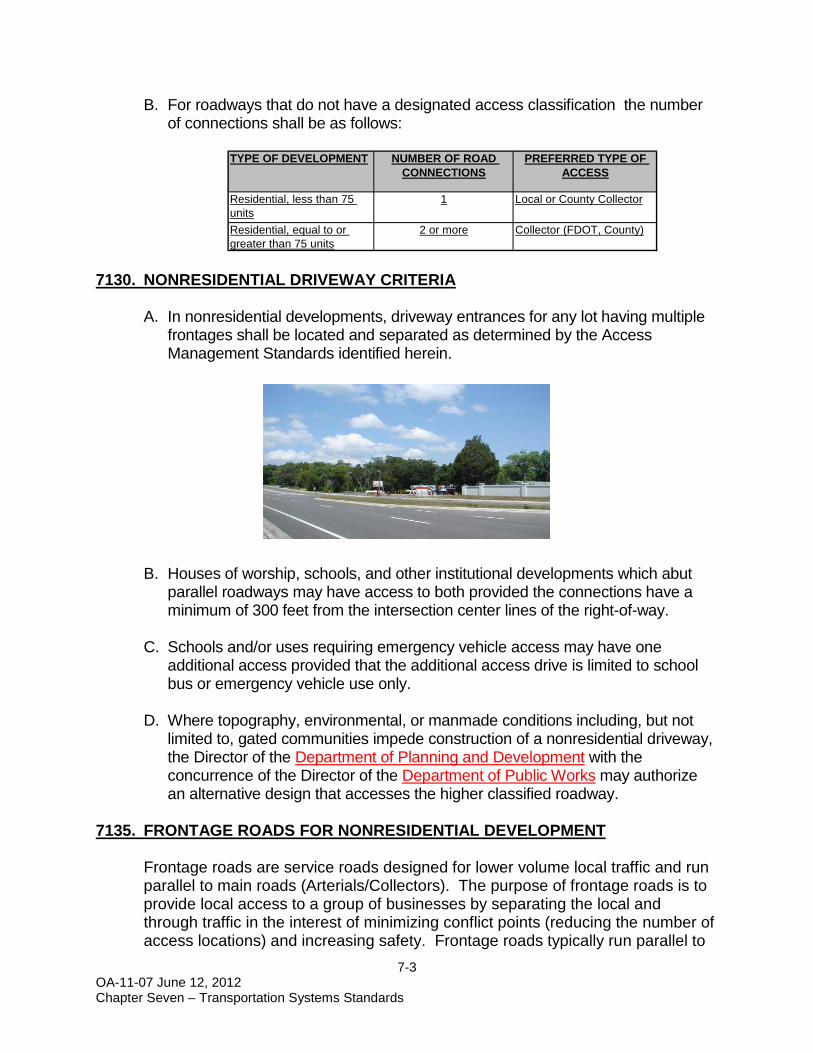
7130. NONRESIDENTIAL DRIVEWAY CRITERIA
A. In nonresidential developments, driveway entrances for any lot having multiple frontages shall be located and separated as determined by the Access Management Standards identified herein.
B. Houses of worship, schools, and other institutional developments which abut parallel roadways may have access to both provided the connections have a minimum of 300 feet from the intersection center lines of the right-of-way.
C. Schools and/or uses requiring emergency vehicle access may have one
additional access provided that the additional access drive is limited to school bus or emergency vehicle use only.
D. Where topography, environmental, or manmade conditions including, but not
limited to, gated communities impede construction of a nonresidential driveway, the Director of the Department of Planning and Development with the concurrence of the Director of the Department of Public Works may authorize an alternative design that accesses the higher classified roadway.
7135. FRONTAGE ROADS FOR NONRESIDENTIAL DEVELOPMENT
Frontage roads are service roads designed for lower volume local traffic and run parallel to main roads (Arterials/Collectors). The purpose of frontage roads is to provide local access to a group of businesses by separating the local and through traffic in the interest of minimizing conflict points (reducing the number of access locations) and increasing safety. Frontage roads typically run parallel to
TYPE OF DEVELOPMENT NUMBER OF ROAD CONNECTIONS
PREFERRED TYPE OF ACCESS
Residential, less than 75 units
1 Local or County Collector
Residential, equal to or greater than 75 units
2 or more Collector (FDOT, County)

7-4 OA-11-07 June 12, 2012 Chapter Seven – Transportation Systems Standards
the main road and are located in front of and in between the buildings served and the main roads. Reverse frontage roads run parallel to the main road and are typically located behind the buildings served, instead of between the buildings and the main road.
Developers of properties adjacent to Arterials or Collectors may provide at the developer's expense a frontage road from property line to property line parallel to the Arterial or Collector. This is a valid substitute to the requirement to provide cross access per the LDC.
Design Guidelines: A. Frontage roads generally will be parallel or perpendicular to the front property
line and may be located either in the front of, adjacent to, or behind the principal buildings. In considering the most appropriate alignment, the County shall consider the setbacks of existing and proposed buildings and the anticipated traffic flow for the site. The frontage road may be approved in order for construction to be within the front yard setback provided there is the required distance between the frontage road and the existing major road so as not to create a traffic hazard, and in accordance with the requirements of this LDC.
B. A frontage road shall be within an access easement or platted right-of-way
allowing traffic circulation between adjoining properties. The platted right-of-way or easement shall be a minimum of fifty (50) feet wide and designed and constructed in accordance with the following figure:

7-5 OA-11-07 June 12, 2012 Chapter Seven – Transportation Systems Standards
C. Frontage roads are intended to be used exclusively for circulation and not as parking. The County may require the posting of no parking signs along the frontage road.
D. Driveway spacing along the frontage road shall be as necessary for safe
traffic movement, and as authorized by the County Engineer or his designee. E. The posted speed limit along the frontage road shall be 25 mph.
7140. ACCESS MANAGEMENT FOR COUNTY CONTROLLED ROADWAYS
A. Unless specifically listed elsewhere within this section, all connection spacing on roadway segments that have been assigned an access classification shall meet or exceed the minimum requirements of the access class shown in the following tables:

7-6 OA-11-07 June 12, 2012 Chapter Seven – Transportation Systems Standards
TABLE 7-1 ACCESS CLASSIFICATION AND SPACING REQUIREMENTS
Functional Class Access Class Medians +
Connections Spacing (feet) Posted Speed
Greater than 50 MPH
Posted Speed of 50 or less
Principal Arterials 3 Restrictive 660 440 Principal Arterials/ Major Collectors
4 Nonrestrictive 660 440 5 Restrictive 440 245
Minor Arterials/ Minor Collectors Local Streets
6 Nonrestrictive 440 245
7 Both Median Types 125 125
Functional Class Access Class Medians +
Median Opening Spacing
More than 50 MPH
Signal Spacing
More than 50 MPH Directional Full
Principal Arterials 3 Restrictive 1320 2640 2640
Principal Arterials/ Major Collectors
4 Nonrestrictive --- --- 2640
5 Restrictive 660 2640 2640
Minor Arterials/ Minor Collectors Local Streets
6 Nonrestrictive --- --- 1320
7 Both Median Types 330 660 1320
Functional Class Access Class Medians +
Median Opening Spacing
50 MPH or less
Signal Spacing
50 MPH or less Directional Full
Principal Arterials 3 Restrictive 1320 2640 2640 Principal Arterials/ Major Collectors
4 Nonrestrictive --- --- 2640 5 Restrictive 660 1320 1320
Minor Arterials/ Minor Collectors Local Streets
6 Nonrestrictive --- --- 1320
7 Both Median Types 330 660 1320
+ A “Restrictive” median physically prevents vehicle crossing. A “Nonrestrictive” median allows turns across any point.
7-7 OA-11-07 June 12, 2012 Chapter Seven – Transportation Systems Standards
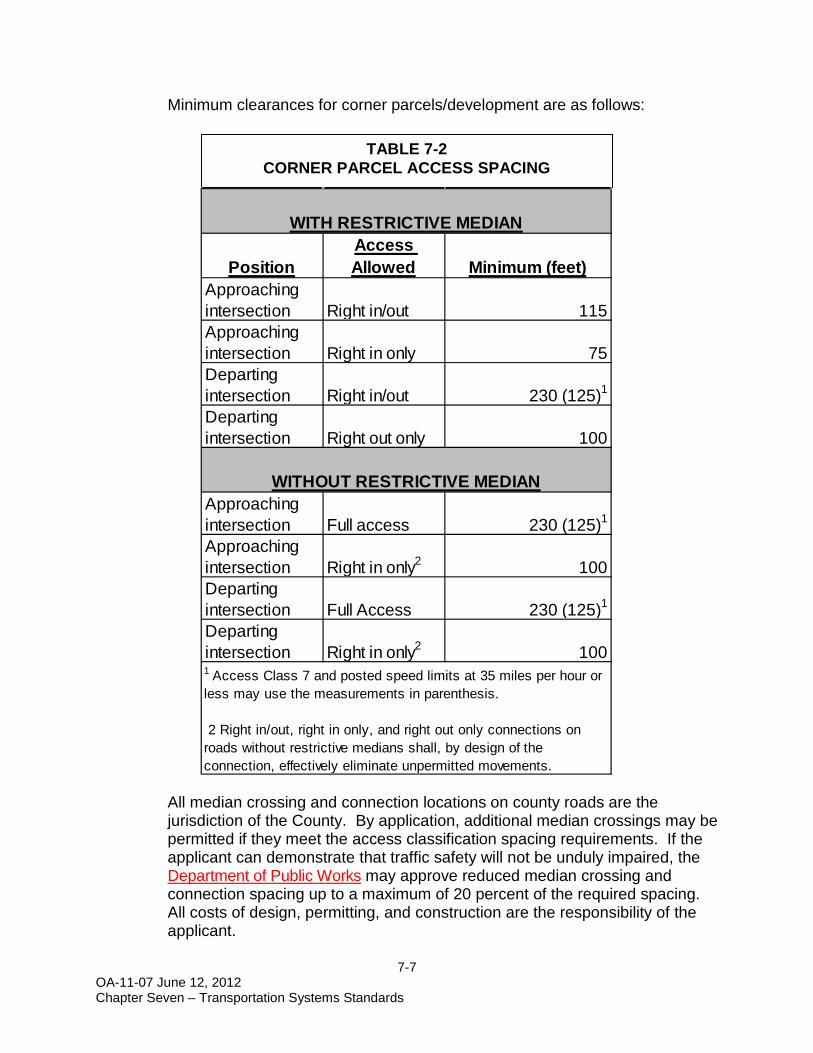
Minimum clearances for corner parcels/development are as follows: All median crossing and connection locations on county roads are the jurisdiction of the County. By application, additional median crossings may be permitted if they meet the access classification spacing requirements. If the applicant can demonstrate that traffic safety will not be unduly impaired, the Department of Public Works may approve reduced median crossing and connection spacing up to a maximum of 20 percent of the required spacing. All costs of design, permitting, and construction are the responsibility of the applicant.
TABLE 7-2 CORNER PARCEL ACCESS SPACING
PositionAccess Allowed Minimum (feet)
Approaching intersection Right in/out 115Approaching intersection Right in only 75Departing intersection Right in/out 230 (125)1
Departing intersection Right out only 100
Approaching intersection Full access 230 (125)1
Approaching intersection Right in only2 100Departing intersection Full Access 230 (125)1
Departing intersection Right in only2 100
WITH RESTRICTIVE MEDIAN
WITHOUT RESTRICTIVE MEDIAN
1 Access Class 7 and posted speed limits at 35 miles per hour or less may use the measurements in parenthesis.
2 Right in/out, right in only, and right out only connections on roads without restrictive medians shall, by design of the connection, effectively eliminate unpermitted movements.

7-8 OA-11-07 June 12, 2012 Chapter Seven – Transportation Systems Standards
B. CR-486 Access Classification
C. Driveway Throat Distances for all County Classified Roadways: The
minimum length of driveways, or throat distance, shall vary based upon the proposed land use for the particular parcel of land and the projected daily and peak hour traffic volumes for the proposed development on the property. The driveway throat distance shall be measured from edge of traveled way to the first internal drive. To minimize potential vehicle stacking that would present a traffic operational or safety concern on arterial and collector roadways, the minimum throat distance for any driveway subject to the Access Plan shall be the following:
CLASSIFICATION55555
7
5
5N Skeeter Terrace to US-41
N. Ottawa Avenue to N. Leesburg AvenueNorth Leesburg Avenue to N. Annapolis Avenue
N. Annapolis Avenue to 1,200 Feet East of N. McGee Drive1,200 Feet East of N. McGee Drive to N Skeeter Terrace
SEGMENTSR-44 to N. Marcus Gunn PointN. Marcus Gunn Point to N. Pinecone AvenueN. Pinecone Avenue to N. Ottawa Avenue
Distance Required (Feet) Distance Required (Feet)Peak Hour Trips With Right Turn Lane Without A Right Turn Lane50 or less 15 3051 to 99 25 50100 or more 75 150
DRIVEWAY THROAT DISTANCE
Driveway Throat Distance
THROAT DISTANCE
INTERNAL DRIVE

7-9 OA-11-07 June 12, 2012 Chapter Seven – Transportation Systems Standards
7150. ACCESS MANAGEMENT FOR STATE HIGHWAYS
A. Standards for minimum spacing of access points for all arterial highways shall be by posted speed, in accordance with Chapter 14-97, F.A.C., FDOT Access Management Standards. The access spacing shall be as follows:
FDOT ACCESS MANAGEMENT CLASSIFICATIONS
STATE HIGHWAY FROM TO CLASS
US-41
Hernando County Line CR 48 4 CR48 SR-44 and Highland Blvd. 5 SR-44 and Highland Blvd. Montgomery Ave. 6 Montgomery Ave. Marion County Line 3
US-19 and 98
Hernando County Line CR-44/W. Fort Island Trail 3 CR-44/W. Fort Island Trail SR-44/NE 5th St. 6 SR-44/NE 5th St. NW 7th St. 4 NW 7th St. Levy County Line 3
SR-200 US-41 Marion County Line 3
SR-44
US-19 and 98 Joyner Rd. 6 Joyner Rd. 680 feet West of CR-581 3 680 feet West of CR-581 US-41/N. Florida Ave. 6 US-41/N. Florida Ave. US-41/S. Florida Ave. 6 US-41/S. Florida Ave. Sumter County Line 3
US – 98 Hernando County line US-19 3
B. US-19 Access Management Plan Standards
The following access management standards for development activities are hereby established as the US-19 Access Management Plan standards for all
MEDIAN SIGNAL SPACING
STANDARD (feet)
Full Directional Posted Speed Greater than 45
Posted Speed of 45 MPH or less
2 Restrictive 2,640 1,320 2,640 1,320 6603 Restrictive 2,640 1,320 2,640 660 4404 Non-Restrictive N/A N/A 2,640 660 4405 Restrictive 2,640 / 1,320* 660 2,640 / 1,320* 440 2456 Non-Restrictive - - 1,320 440 2457 Both Median Types 660 330 1,320 125 125
*Note: Greater than 45 MPH/Less than or = 45 MPH
CONNECTION SPACING STANDARD (feet)
MEDIAN OPENING SPACING STANDARD (feet)
FDOT ACCESS MANAGEMENT SPACINGACCESS CLASS

7-10 OA-11-07 June 12, 2012 Chapter Seven – Transportation Systems Standards
development abutting the US-19 corridor commencing at the Hernando County Line and terminating at the Levy County line. This section also includes those properties abutting US-19 that were within the County’s jurisdiction prior to the annexation adopted on April 26, 2004 by the City of Crystal River.
1. Plan Runs with the US-19 Corridor: The US-19 Access Management Plan
shall apply, to the maximum extent permitted by law, to the US-19 corridor commencing at the Hernando County Line and terminating at the Levy County line. The Access Plan shall be applicable, to the maximum extent permitted by State law, regardless of the local governmental jurisdiction of the properties located in the US-19 corridor.
2. Access Classification: The FDOT has classified the roadway section
specifically included in the Access Plan as an Access Class 3 facility. A Class 3 facility has restrictive (raised) medians, directional median opening minimal spacing of 1,320 feet, and full median opening minimal spacing of 2,640 feet. The Access Plan utilizes these standards as guidelines for the placement of median openings.
3. Frontage or Reverse Frontage Roads: Parcels that are adjacent to or in
close proximity to frontage or reverse frontage roads as depicted in the Access Plan shall provide a connection to this roadway. As a condition of development approval, a development plan must provide for the construction of the section of frontage road or reverse frontage road that provides access to US-19 as identified in the Access Plan. This shall be accomplished as practical and may necessitate an escrow of funds and/or development agreement for future construction to be determined by the Director of the Department of Public Works.
4. Joint and Cross Access: Each development plan shall provide for
appropriate stub-outs to support cross access between adjacent parcels.

7-11 OA-11-07 June 12, 2012 Chapter Seven – Transportation Systems Standards
5. Driveway Spacing Standards: The minimum separation distance between
adjacent driveways shall conform to the FDOT Access Management standards according to the assigned access design classification. The County shall require a minimum driveway spacing of 660 feet where feasible and practicable consistent with sound and generally accepted engineering practices and principles.
6. Driveway Throat Distances: The minimum length of driveways, or throat
distance, shall vary based upon the proposed land use for the particular parcel of land and the projected daily and peak hour traffic volumes for the proposed development on the property. The driveway throat distance shall be measured from edge of traveled way to the first internal drive. To minimize potential vehicle stacking that would present a traffic operational or safety concern on US-19, the minimum throat distance for any driveway subject to the Access Plan shall be the following:
Distance Required (Feet) Distance Required (Feet)Peak Hour Trips With Right Turn Lane Without A Right Turn Lane50 or less 15 3051 to 99 25 50100 or more 75 150
DRIVEWAY THROAT DISTANCE
Driveway Throat Distance
THROAT DISTANCE
INTERNAL DRIVE

7-12 OA-11-07 June 12, 2012 Chapter Seven – Transportation Systems Standards
7. Isolated Corner Properties: Properties located at the intersection of a roadway and US-19 are considered isolated corner properties and development on such properties may be permitted to have only right-in and right-out driveway access on US-19 with all driveways located as far as and feasible, consistent with sound and generally accepted engineering practices and principles, away from the roadway intersection.
8. Continuous Right Turn Lanes: Development plans shall avoid the use of
continuous right-turn lanes that access several contiguous properties. The use of shared, joint or cross access and interconnected parking lots and frontage roads shall be maximized in each development plan to accomplish property access along the US-19 corridor. Appropriate easements and other rights shall be deeded to the County, when appropriate, to implement this requirement.
9. Commercial Nodes: The Access Plan has been developed to be
consistent with and compatible to the provisions of the Citrus County Comprehensive Plan for Community, General, and Regional Commercial Nodes. Full median openings depicted on the Access Plan within these nodes have been located to meet, to the greatest extent feasible and practicable consistent with sound and generally accepted engineering practices and principles, the spacing requirement of 2,640 feet as specified in the aforementioned Sections.
10. Wetland/Environmentally Sensitive Areas: Environmentally sensitive
areas have been tentatively identified in the Access Plan and access to these areas has been reasonably limited. Consistent with the objective of preserving environmentally sensitive lands, access over properties identified as such lands is prohibited; provided, however, that the owner or developer may apply for a variance pursuant to the provisions of this Chapter and as otherwise provided in this LDC. The specific limits of the environmentally sensitive areas shall be verified and depicted in each development plan prior to the review and approval of the development plan. The intent of the Access Plan is to minimize any disturbance of all environmentally sensitive lands while providing for the reasonable use of developable property and reasonable access to property.
11. Minimum Lot Widths: The depth of any lot shall not exceed three times its
width. In addition, the minimum lot width for purposes of this plan shall be 100 feet for residential lots and 150 feet for nonresidential lots. Lot aggregation for purposes of proposed development plans shall be encouraged for any parcels of record that do not meet this requirement and cause adverse impacts to traffic circulation.

7-13 OA-11-07 June 12, 2012 Chapter Seven – Transportation Systems Standards
12. Lot Splits: No new or additional access rights will be permitted for properties that are created as the result of parcel or lot splits subsequent to August, 2004.
13. Deviations/Variances from Standards: The applicant for any development
plan shall have the burden of providing substantial competent evidence including, but not limited to, evidence from a licensed Florida professional engineer or other expert in the field of transportation/land use planning, demonstrating hardship and unique conditions that prohibit a development plan from conforming with the requirements of the Access Plan. The applicant must provide compelling data and analysis to the County that a requested variance would improve traffic circulation and efficiency of and the general safety of the citizens of Citrus County and the traveling public on US-19; that no alternative access exists from a street with a lower functional classification than US-19; and that there is no possible access from a joint and cross access agreement, shared driveway, frontage road or reverse frontage road. The deviations from standards process shall be consistent with the County’s variance process, and shall include a public notification process. Decisions from the County’s variance process shall be forwarded to the FDOT, District 7, Access Management Review Committee, for review and consideration.
14. Interim Access: Any access point or median opening that does not
comply with one (1) or more provisions of this Subsection may be designated as Interim Access upon approval by the Planning and Development Commission (PDC) or Director of the Land Development Division based upon the requisite and competent evidence being submitted by the applicant and accepted by the County. In all cases where the access is designated as Interim Access, such access shall be specifically noted on the site plan or subdivision plan submitted for approval. The requirement to provide subsequent alternative access shall run with the property and be a condition of development approval. The future planned alternative access shall be specifically identified. When the property is capable of being served by an alternate means of access, the Director of the Land Development Division or PDC shall require that the Interim Access be eliminated or altered, at the cost of the applicant, and that the property utilize the new access location that is consistent with the provisions of this Subsection.
15. Interchange Management Area. Interchange Management Area criteria
are outlined in Section 7400, Interchange Management Areas.

7-14 OA-11-07 June 12, 2012 Chapter Seven – Transportation Systems Standards
7160. PEDESTRIAN ACCESS STANDARDS
Where a proposed non-residential development abuts a collector or arterial roadway listed in the Citrus County Transportation Alternatives List of Priority Projects, facility designs shall include provision for sidewalks or other approved pedestrian facilities. The following standards shall be applied when considering sidewalk placement:
A. External sidewalks on Collector or Arterial Roadways
External sidewalks shall be located on collector or arterial roadways adjacent to a non-residential development. Sidewalks shall be constructed on the development’s side of the existing collector or arterial for the extent of the project boundary.
1. The developer shall be responsible for the construction of the
sidewalks.
2. Where natural features, pre-existing development conditions, or site design cause requirements for sidewalks to be physically infeasible, waiving this requirement or alternate designs may be approved as determined by the Director of the Department of Public Works. In lieu of construction along the external roadway, the developer may pay a sidewalk fee to the County in an amount necessary to complete construction. This amount shall be determined by the project engineer and approved by the County with payment required prior to final plan approval. Payment will be due prior to subdivision final plat approval or commercial compliance approval. The County may use these funds toward the construction of sidewalks throughout the County based on priorities established by the Board of County Commissioners in conformance with the Citrus County Transportation Alternatives List of Priority Projects.
B. Whenever possible, sidewalks and/or trails shall be provided for
convenient access to individual dwelling units, churches, schools, parks, activity centers, transit facilities and other facilities.
C. To ensure safety and accessibility, all schools shall be linked with
residential areas by bikeways and sidewalks whenever possible D. Sidewalks shall comply with ADA requirements.

7-15 OA-11-07 June 12, 2012 Chapter Seven – Transportation Systems Standards
7170. STANDARDS FOR DRIVE-UP FACILITIES
All facilities providing drive-up or drive-through service shall provide onsite stacking lanes in accordance with the following standards: A. Drive-in facilities and stacking lanes shall be located and designed to
minimize turning movements relative to driveway access to streets and intersections.
B. Drive-in facilities and stacking lanes shall be located and designed to minimize or avoid complete conflicts between vehicular traffic and pedestrian areas such as sidewalks, crosswalks, or other pedestrian access ways.
C. A bypass lane shall be provided.
D. Stacking lane distance shall be measured from the first service window to the property line bordering the furthermost street providing access to the facility.
E. Minimum stacking lane distance shall be as follows:
Use Queue Distance
Required Fast-Food Restaurant 225 Ft.
Financial Institution 175 Ft. Drugstore 100 Ft.
Car Wash (Self-Service) 50 Ft. Other Uses 120 Ft.
F. Alleys or driveways in or abutting areas designed, approved, or developed for
residential use shall not be used for circulation of traffic for drive-up facilities.
G. Where turns are required in the exit lane, the minimum distance from any drive-up station to the beginning point of the curve shall be 34 feet. The minimum inside turning radius shall be 25 feet.

7-16 OA-11-07 June 12, 2012 Chapter Seven – Transportation Systems Standards
7180. CLEAR VISIBILITY TRIANGLE
In order to provide a clear view of intersecting streets and nonresidential driveway entrances to the motorists, there shall be a triangular area of clear visibility. The following standards shall be met:
A. Nothing shall be erected, placed, planted, or allowed to grow in such a
manner as to materially impede vision between a height of three feet and eight feet above the grade. For the intersection of rights-of-way, grade shall be measured from the intersection of the centerline of the rights-of-way. For driveways, grade shall be measured from the centerline of the intersection of the driveway and right-of-way. Upon a finding by the staff, existing natural features and topography which prohibit compliance with this requirement may require removal and/or grading of such features. Historical and/or archaeological significant sites subject to requirements contained herein, and protected trees pursuant to requirements contained herein, may be exempt from this requirement.
B. Street Intersections - Nonresidential and Residential Development The clear visibility triangle shall be formed by drawing a line 25 feet along each property line abutting the right-of-way starting at the point where the two property lines intersect, or their projections intersect, then connecting the two end points with a straight line.

7-17 OA-11-07 June 12, 2012 Chapter Seven – Transportation Systems Standards
C. Driveway Entrances - Nonresidential Development Only Intersections of driveways with streets shall provide a Clear Visibility Triangle as shown in the figure below. Beginning at the intersection of the driveway edge with the street right-of-way (property line), thence along the street right-of-way for a distance of 25 feet, thence in a straight line across the property to a point on the edge of the driveway 25 feet from the point of beginning. Where driveways are curved or intersect with the street at other than right angles, the visibility triangle shall be measured from the point of the curve most projecting into the driveway. The visibility triangle shall be provided on each side of a driveway.
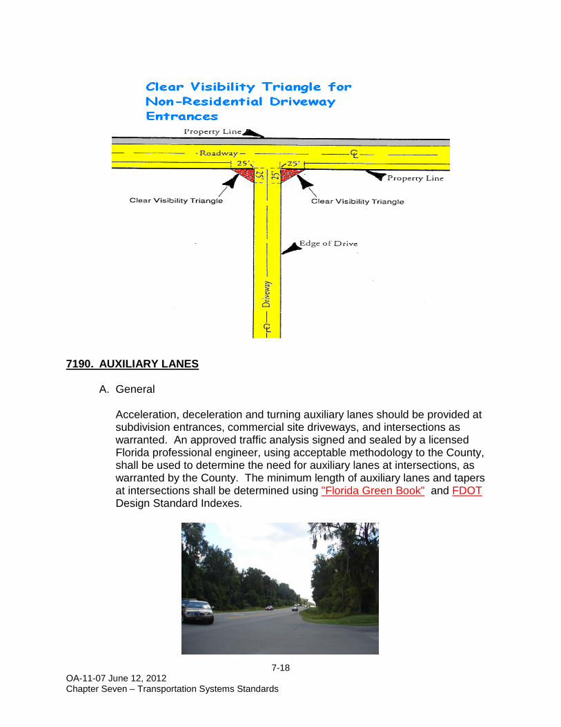
7-18 OA-11-07 June 12, 2012 Chapter Seven – Transportation Systems Standards
7190. AUXILIARY LANES
A. General
Acceleration, deceleration and turning auxiliary lanes should be provided at subdivision entrances, commercial site driveways, and intersections as warranted. An approved traffic analysis signed and sealed by a licensed Florida professional engineer, using acceptable methodology to the County, shall be used to determine the need for auxiliary lanes at intersections, as warranted by the County. The minimum length of auxiliary lanes and tapers at intersections shall be determined using "Florida Green Book" and FDOT Design Standard Indexes.

7-19 OA-11-07 June 12, 2012 Chapter Seven – Transportation Systems Standards
B. Applicability
1. Developments which generate a.m. or p.m. peak hour traffic exceeding the following thresholds shall provide site related acceleration, deceleration, and storage lanes:
More than twenty (20) left turning vehicles per hour on a two lane arterial or collector roadway
Left turn lanes are to be provided
More than forty (40) right turning vehicles per hour on a two lane arterial or collector roadway
Right turn lanes are to be provided
More than forty (40) right turning vehicles per hour, on a four lane rural roadway Right turn lanes are to be provided,
More than eighty (80) right turning vehicles per hour, on a four lane urban roadway
Right turn lanes are to be provided
More than Sixty (60) right turning vehicles per hour, on a six lane rural roadway Right turn lanes are to be provided
More than one hundred (100) right turning vehicles per hour, on a six lane urban roadway
Right turn lanes are to be provided
2. The following are conditions that also can warrant an exclusive right turn
lane without meeting the above requirements.
a. Facilities having a high volume of buses, trucks, Recreational Vehicles (2 or 3 per hour)
b. Sites not meeting adequate throat distance c. Driveways where curves or hills impact sight distance d. Gated Entrances, if not meeting setback requirements or high peak
hour traffic e. Crash Experience f. Severe Skewed angle of intersection requiring right turn vehicle to slow
greatly.
3. If an applicant objects to the requirement for turn lanes, an approved traffic analysis outlining a design exception request may be submitted for review and approval, at the sole discretion of the Citrus County Department of Public Works Director

7-20 OA-11-07 June 12, 2012 Chapter Seven – Transportation Systems Standards
C. Left-turn Lanes
A left turn lane is recommended for any intersection that exceeds 20 turning vehicles per hour on multi-lane roadways. Exclusive left turn lanes are identified as required per the Highway Capacity Manual’s Level of Service analysis for multi-lane collector roadways. Two-way continuous left turn lanes shall be designed per FDOT guidelines, as outlined in the "Florida Green Book" and the FDOT Plans Preparation Manual.
D. Free Flow Lanes / Slip Lanes
A free flow right turn lane is an exclusive right-turn lane that can accommodate turning volumes, into a dedicated side street or driveway providing there is no left turn movement into the driveway delineation. Free flow turn lanes should be separated from the through movement of traffic by either a triangular raised or painted divisional island. To be considered a free flow, the required receiving lane and queuing must be entirely onsite, with a minimum queue length of 150’.
7195. FUNCTIONAL CLASSIFICATION MAP SERIES
The Functional Classification Map Series is intended to identify existing and future roadways which function as important traffic corridors. Roadways identified on the Functional Classification Map Series may be subject to special development regulations in an effort to provide safe and efficient traffic flow. The following road classifications are defined in Chapter One of this LDC: Principal Arterial, Minor Arterial, Major Collector, Minor Collector, and Local. Road classifications are established based on function, traffic counts, existing and future traffic flow, and classifications assigned by FDOT and within the Comprehensive Plan. The list below identifies the roadways.

7-21 OA-11-07 June 12, 2012 Chapter Seven – Transportation Systems Standards
Principal Arterials Carl G. Rose Highway (SR-200), North Florida Avenue (US-41), North and South Gulf to Lake Highway (SR-44), East and West Ponce de Leon Boulevard (US-98), West Suncoast Boulevard (US-19), North and South Minor Arterials Forest Ridge Boulevard, North Lecanto Highway (CR-491), North and South Norvell Bryant Highway (CR-486), East and West Pleasant Grove Road (CR-581), South Major Collectors Anna Jo Drive, East Apopka Avenue, South Cardinal Street (CR-482), West Croft Avenue, North and South Crystal Oaks Drive, West Dunnellon Road (CR-488), West Emeraldd Oaks Drive, West Essex Avenue, North Grover Cleveland Boulevard, West Halls River Road (CR-490A), West Highview Avenue, North Homosassa Trail (CR-490), West Independence Highway, North Istachatta Road (CR-39), South Oak Park Boulevard (CR-480), West and East Rock Crusher Road, North and South Stage Coach Trail (CR-480), East and West Turkey Oak Drive, North Venable Street, West Yulee Drive (CR-490), West Portions of the following roads: Bushnell Road (CR-48), East from E. Orange Avenue (CR-48) to Sumter
County line Citrus Avenue (CR-495), North, from N. Turkey Oak Drive to CR-488 Fresno Avenue, North from W. Pearson Street to W. Keller Street Gospel Island Road (CR-470), East from City limits to SR-44 Keller Street, West from N. Fresno Avenue to N. Essex Avenue Orange Avenue (CR-48), East from US-41 to E. Bushnell Road Pearson Street, West from N. Highview Avenue to N. Fresno Avenue
7-22 OA-11-07 June 12, 2012 Chapter Seven – Transportation Systems Standards
Pearson Street, West from N. Quartz Avenue to N. Quartz Avenue Minor Collector Annapolis Avenue, North Arbor Street, East Basswood Avenue, North Bradshaw Street, West Canary Palm Terrace, South Citrus Hills Boulevard, North Citrus Springs Boulevard, East, West, and North Corkwood Boulevard Country Club Boulevard, West Country Club Way, North Cypress Boulevard, East and West Cypress Circle Deltona Boulevard, North Dunkenfield Avenue, North Dunklin Street, West Eden Drive Elkcam Boulevard, North Fishbowl Drive, West Floral Park Drive, East Gobbler Drive (CR-39A), East Great Oaks Drive, South Green Acres Street, West Hartford Street, East Kensington Avenue, North and South Longfellow Street, West Miss Maggie Drive, West Mustang Boulevard, West Northcut Avenue, North Oak Village Boulevard Oak Village Boulevard, South Oaklawn Street, West Old Floral City Road, South Otis Avenue, South Ottawa Avenue, North Pine Ridge Boulevard, West Riverwood Road, West Roosevelt Boulevard Roosevelt Boulevard, West Steven Street, East Trails End Road (CR-39A), East Turner Camp Road (CR-581), East Withlacoochee Trail (CR-39), East and West

7-23 OA-11-07 June 12, 2012 Chapter Seven – Transportation Systems Standards
Withlapopka Drive (CR-39A), South Portions of the following roads: Carnegie Drive, from Eden/Moccasin Slough to Old Floral City Road Century Boulevard, West from N. Elkcam Boulevard to N/W Citrus Springs
Boulevard Citrus Avenue, North from CR-488 to West Riverbend Road Country Club Boulevard, West from US-41 to N. Deltona Boulevard Dawson Drive, East from N. Croft Avenue to N. Independence Highway Fort Island Trail (CR-44), West from Fort Island Park to US-19 Moccasin Slough Road, East from S. Carnegie Drive to Martinis Drive Ozello Trail (CR-494), West from US-19 to West Beachview Drive Parsons Point Road, East from US-41 to North Wheaton Point Quartz Avenue North from W. Union Street to W. Olympia Street Reehill Street, East, from N. Citrus Hills Boulevard to N. Kensignton
Avenue River Road, West from US-19 to N. Caribee Point Riverbend Road, West from CR-488 to N. Citrus Avenue Sandpiper Drive, East from S. Old Floral City Road to S. Canal Road Union Street, West, from S. Otis Avenue to N. Quartz Avenue
7200. OFF STREET PARKING AND LOADING 7210. APPLICABILITY
The provisions of this section shall apply to new development, redevelopment, or amendments to existing development approvals, as follows:
A. Nonresidential Development. A change in use of a nonresidential property,
building, or structure, or conversion of an existing residential use to a nonresidential use shall require that the total parking requirement for the new use be met. An increase in total floor area of a building or structure shall require that the total parking requirement, based upon the existing floor area of the building or structure and the increased floor area, be met.
B. Residential Development. Changes to approved development plans that
result in an increase in the number of dwelling units shall include provisions for the total parking requirement specified in this section.
C. Status of Prior Approvals. Projects with unexpired development plans, must
meet only the parking requirements in effect at the time of development plan approval. However, should the unexpired development plan be amended, total parking requirements shall be met.

7-24 OA-11-07 June 12, 2012 Chapter Seven – Transportation Systems Standards
7220. MAINTENANCE
All off-street parking areas shall be well maintained; free of potholes, debris, weeds, broken curbs, and broken wheel stops; clearly striped; and with all lighting in working condition. Facilities shall be maintained as soon as the use exists which the facilities were designed to serve.
7230. PARKING SPACES REQUIRED
A. Table of required parking spaces specifies the required minimum number of off-street automobile parking spaces, the maximum percentage that may be allocated for compact vehicles, if any, and any special requirements which may apply. The number of parking spaces required for uses not specifically listed in the matrix shall be determined by staff. County staff shall consider requirements for similar uses and appropriate traffic engineering and planning data, and shall establish a minimum number of parking spaces based upon the principles of the Institute of Transportation Engineers (ITE).
B. Where a mixed use development is proposed, whether the mixed uses are in
separate buildings within a development or in a single building, the parking standards for each proposed use shall be required, unless a reduction is granted as provided for herein.
C. Certain large scale uses have a substantial variability in parking demand with
the result that literal application of the standards in this section may not provide an appropriate amount of parking. In such cases, a parking study is required to be submitted with the development proposal to justify the proposed parking requirement. The final decision on the amount of parking shall be made in consideration of the parking study along with traffic engineering and planning data that are appropriate to the proposed development and use.
D. Where alternative designs are not feasible or practical, a reduction (not to
exceed two spaces) in required parking may be granted to preserve existing regulated and/or specimen trees as defined herein. In making this

7-25 OA-11-07 June 12, 2012 Chapter Seven – Transportation Systems Standards
determination for a parking reduction, maximum preservation of existing trees and onsite parking and circulation shall be considered.
E. Projects requiring 15 or more spaces may construct only 80 percent of the
required spaces provided the following standards are met:
1. The project is in compliance with the impervious surface ratio requirements contained herein of this LDC based on the full parking requirements.
2. The stormwater retention system is designed based on the full parking
requirements.
3. The remaining 20 percent, if not initially constructed, must remain in a natural or landscaped vegetative state.
4. One hundred percent (100%) of the required spaces shall be built with
development order approval for 80% occupancy of the building.
F. Projects requiring 100 or more parking spaces may allocate 15 percent of the required spaces as compact spaces using the compact parking space dimensions table below provided the following standards are met:
1. Compact spaces must be grouped within a common area. 2. Compact spaces shall be conspicuously designated as reserved for small
or compact cars only. 3. Parking areas and uses with high turnover (for example: retail uses,
grocery stores, medical and health care facilities) shall not have compact parking spaces.

7-26 OA-11-07 June 12, 2012 Chapter Seven – Transportation Systems Standards
Specific Use Required Parking Spaces
Residential Uses
Dwelling, Single-Family Detached and Duplex 2 per dwelling unit.
Dwelling, Single-Family Attached 1.5 per dwelling unit
Dwelling Multi-Family 1.4 per dwelling unit
Dwelling, Multi-Family Time-Share 1 per bedroom
Community Residential Home 2 plus 1 additional space for each 4 authorized residents over 6
Continuing Care Retirement Community 1 per dwelling unit or bedroom
Assisted Living Facility 0.5 space per living unit
Nursing Home 1 for each two authorized beds
Institutional Uses (see also Places of Public Assembly)
School, Elementary 1 per 7 students, or 1 per 6 persons of seating capacity in an included auditorium, , whichever is greater
School, Middle or Junior High 1 per 6 students, or 1 per 6 persons of seating capacity in an included auditorium whichever is greater;
School, High 1 per 2.5 students or 1 per 6 persons of seating capacity in an included auditorium, whichever is greater
College, University, Junior College or Vocational School 1 per 3 persons (students, faculty and other employees) on-campus at peak time
Hospital 4 per authorized patient bed
Other Institutional Use 1 per 500 square feet of gross leasable area or 1 per employee, plus 1 for each 2 persons in the computed capacity of the facility, whichever is greater.
Daycare 1 space per staff member and 1 space for every 5 children
Places of Public Assembly
House of Worship 1 per 3 persons of seating capacity.
Theater or Auditorium 1 per 3 persons of seating capacity
Office and Similar Uses
Bank 1 per 300 square feet of floor area
Medical and Dental Offices and Clinics, Veterinary Hospitals and Clinics
1 per 200 square feet of gross floor area.
General and Non-Medical Professional Office 1 per 300 square feet of gross leasable area.
Parking Schedule

7-27 OA-11-07 June 12, 2012 Chapter Seven – Transportation Systems Standards
Public and Quasi-Public UsesAirport/Airfield 1 per 5 a i rcraft tiedowns, plus 1 per 5 a i rcraft s torage areas ; 2
spaces for every 3 employees on the largest shi ft, plus 1 space for every vehicle customari ly used in operation of the use or s tored on the premises ; plus 1 space for every 200 square feet of lobby area.
Governmenta l Office Faci l i ty Serving the publ ic 1 per 250 square feet of gross leasable area.Retail and Non-Vehicular Service Uses
Commercia l , Genera l Reta i l in centers of 400,000 square feet or greater
1 per 300 square feet of gross leasable area.
Convenience Reta i l and Grocery, freestanding, less than 3,000 square feet
1 per 200 square feet of gross floor area; i f fuel sa les are offered, parking spaces for that use are in addition to this
Flea Market, Open or Closed 1 per 250 square feet of gross leasable area.Hardware, Pa int, Home Improvements Store 1 per 250 square feet of gross floor areaShopping Centers , Mixed Use Same as genera l reta i l provided that restaurant uses do not
exceed 20 percent of gross leasable area; i f cinema or theater i s included, additional parking must be provided at rate of 1 per 6 persons of seating capaci ty
Recreation UsesIndoor Recreation 1 per 250 square feet or 4 per lane or court, whichever i s greater
1 per 1,000 square feet of use area. Recreational Faci l i ty
Marina, Boat Dock, Harbor 1 per 5 boat berths and 1 per 1,000 square feet of dry boat s torage area, plus 1 per employee on the largest shi ft.
Gol f Course, not including Driving Ranges or Miniature Gol f
3 spaces per gol f hole, plus 1 per 2 employees
Driving Range and Miniature Gol f 1 space per tee or hole, plus required parking for other uses ons i te.
Gol f and Country Club Required parking for gol f course plus ha l f required parking for restaurant/bar area plus parking for office area
Hospitality and Entertainment Uses (see also Places of Public Assembly)Hotel or Motel 1.1 per s leeping room or renta l uni t, plus ha l f required parking for
restaurant and/or bar plus ha l f required parking for meeting/convention space,.
Restaurant, Bar, Cockta i l Lounge 1 space per 150 square feet of gross floor area, or 1 per 3 persons of seating capaci ty, whichever i s greater,
Restaurant, Fast Food 1 per 70 square feet of gross leasable area, or 1 per 3 persons of seating capaci ty, whichever i s greater
Vehicle ServicesFuel Sa les Space for one vehicle on each s ide of each pump is land, unless a
particular i s land a l lows access only from one s ide; plus 1000 square feet arranged to a l low for s tacking or for use by del ivery trucks ; i f the use a lso includes vehicle services or any type of sa les , parking requirements for those are in addition to this
Truck and Automobi le Services 1 per 500 square feet in addition to work bays plus parking for gasol ine sa les i f offered
Commercia l , Genera l reta i l uses located independently
1 per 250 square feet of gross floor area.
Outdoor Commercia l , Recreational Faci l i ty
Publ ic Camping Ground 1 per camps i te, plus 1 per cabin.
Posta l Station 1 per 125 square feet of gross leasable area; plus 1 per employee on the largest shi ft.
Commercia l , Genera l Reta i l uses in centers of less than 400,000 square feet,
1 per 250 square feet of gross leasable area.
Parking Schedule
7-28 OA-11-07 June 12, 2012 Chapter Seven – Transportation Systems Standards
7240. DESIGN OF PARKING LOTS
A. Parking lot design including, but not limited to, arrangement of spaces, width of aisles and access drives, width, length, and angle of spaces, installation of curbs, etc., shall be as specified in this section.
B. Vehicle wheel stops or other design features, such as curbing, shall be used
so that parked vehicles do not extend more than two (2) feet into any landscape or buffer area nor reduce an abutting sidewalk width to less than five (5) feet.
C. All parking shall be paved and constructed for the anticipated traffic load
according to the specifications of this section, except as follows:
1. Up to 50 percent of the parking spaces may be grass provided that spaces are defined and that aisles and circulation areas shall be paved. This allowance may be granted upon a written request from the applicant and a finding that seasonal use, or non-daily use justifies the request and that there would be no detrimental effect due to erosion or other degrading of the natural environment.
2. For a house of worship, public parks, and other similar uses, where
maximum parking demand is based on special events and is generally limited to one or two days per week, all non-handicapped parking spaces, aisles, and circulation areas may be grass or other alternative surfaces. However, if grass is utilized it must be maintained in a safe and noneroded condition. It should be noted that alternative surfaces may still need to provide drainage retention. This allowance may be approved upon a finding that there would be no detrimental effect due to erosion or other degrading of the natural environment.
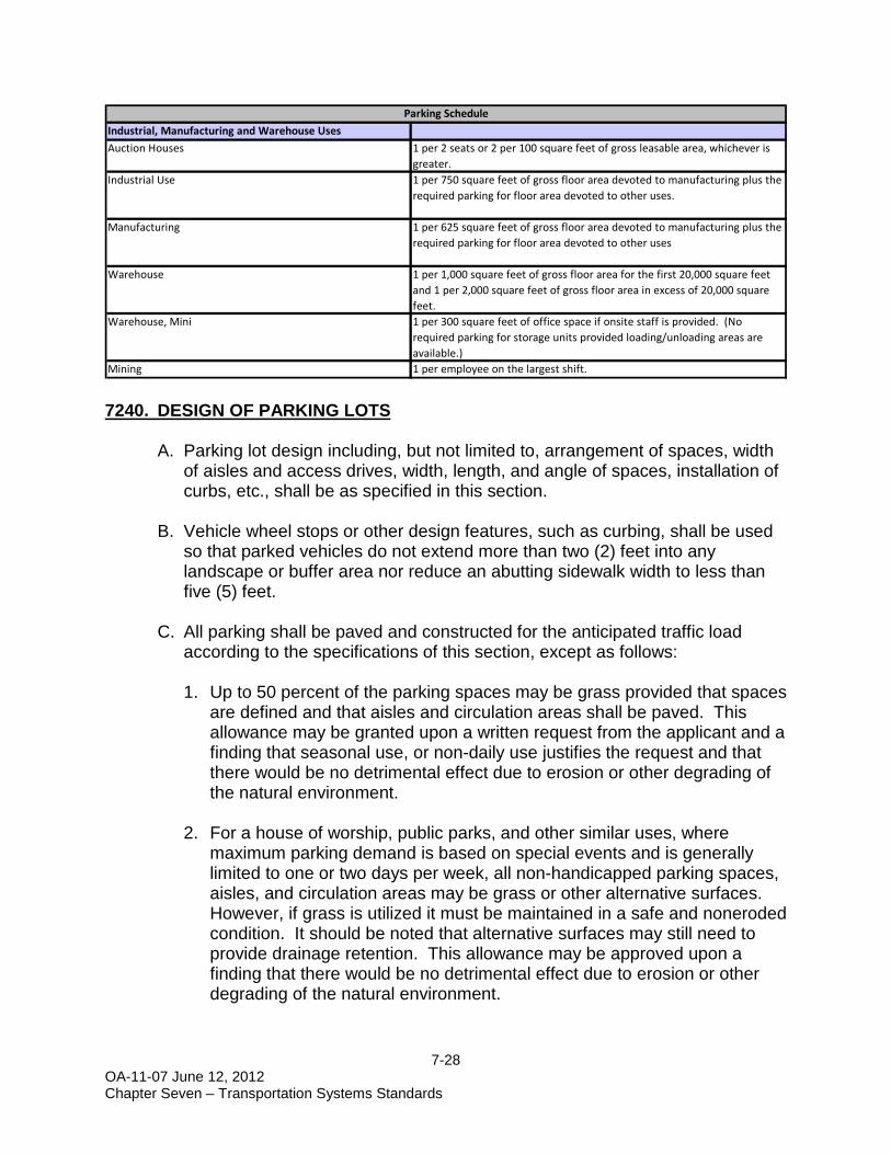
Industrial, Manufacturing and Warehouse UsesAuction Houses 1 per 2 seats or 2 per 100 square feet of gross leasable area, whichever is
greater.Industrial Use 1 per 750 square feet of gross floor area devoted to manufacturing plus the
required parking for floor area devoted to other uses.
Manufacturing 1 per 625 square feet of gross floor area devoted to manufacturing plus the required parking for floor area devoted to other uses
Warehouse 1 per 1,000 square feet of gross floor area for the first 20,000 square feet and 1 per 2,000 square feet of gross floor area in excess of 20,000 square feet.
Warehouse, Mini 1 per 300 square feet of office space if onsite staff is provided. (No required parking for storage units provided loading/unloading areas are available.)
Mining 1 per employee on the largest shift.
Parking Schedule

7-29 OA-11-07 June 12, 2012 Chapter Seven – Transportation Systems Standards
D. Parking lots that have grass parking spaces shall not use unpaved spaces in calculations to meet minimum requirements for buffers or landscaping.
E. Alternate surface materials, including permeable, for parking lots are allowed
providing the permeable surface stormwater requirements contained herein are met if required, and approval by the Engineering Section of the Land Development Division.
7-30 OA-11-07 June 12, 2012 Chapter Seven – Transportation Systems Standards
7250. ADJUSTMENTS TO REQUIRED PARKING
A. Parking Reduction. Upon an approval of a submitted parking study a reduction in required parking for the total off-street parking spaces required by this section can be satisfied. The study shall include, but is not limited to, consideration of the following:
1. Estimates of parking requirements for the proposed use, which shall
include the source(s) of all data, submitted. Estimates shall be based on one or all of the following:
a. Recommendations in studies such as those from the Urban Land
Institute (ULI), ITE, or the Traffic Institute.
b. Data collected from uses, or combinations of uses that are the same, or comparable to the proposed use. Comparability shall be determined by density, scale, bulk, area, type of activity, and location.
2. The extent to which a transportation management system, and use of
alternative modes of transportation, lessens the parking requirement. Consideration for alternative transportation modes shall include, but is not limited to a. Public transportation that satisfies transportation demands for a portion
of the users of the facility corresponding to the amount of parking to be deferred.
b. Ride sharing including private and public car pools, or van pools. c. Flexible work hours scheduling
B. Reduction for Mixed or Joint Use of Parking Spaces. Upon a written request, a reduction in total number of required parking spaces for two or more uses jointly providing off-street parking when their respective hours of need of maximum parking do not normally overlap, may be authorized. Reduction of parking requirements, because of joint use, shall be approved if the following conditions are met:
1. The applicant submits a parking study with sufficient data to demonstrate
that hours of maximum demand for parking by the respective uses do not normally overlap.
2. The applicant submits an agreement, guaranteeing the joint use of off-
street parking spaces so long as the uses requiring parking are in existence or until required parking is provided elsewhere in accordance with the provisions of this LDC.

7-31 OA-11-07 June 12, 2012 Chapter Seven – Transportation Systems Standards
7260. HANDICAPPED ACCESS
All handicapped accessibility shall comply with the standards of the ADA and the Florida Accessibility Code for Building Construction as amended or its successor in function. Determination of compliance shall be made by the Building Official.
7270. TRANSIT/BUS STOPS
A. Any nonresidential development with a parking requirement of more than 250 vehicles or any multifamily development of more than 175 dwelling units shall provide a bus loading/unloading stop (transit facility).
B. The land area dedicated shall be sufficient to provide a bus stop with shelter
and separate paved bus lane. Design of the bus lane shall be approved by the local transit agency.
C. Development on existing County transit routes, shall consider providing a
transit facility in the design. Residential subdivisions, having 40 or more residential units, on an existing County transit route shall provide a transit facility.
7280. BICYCLE PARKING
Bicycle parking shall be provided by all school, multi-family, commercial, and recreation uses, where required parking is 10 or more spaces. A. Spaces
Bicycle parking spaces shall provide space to park bicycles and a means to secure each bicycle without securing it to a light post, bench, tree or other site amenity.

7-32 OA-11-07 June 12, 2012 Chapter Seven – Transportation Systems Standards
B. Number of Spaces
A minimum of one bicycle parking space shall be provided for every ten required vehicular spaces. Additional spaces may be required for private schools, libraries, and recreational facilities. At least two spaces shall be provided for each public and employee entrance by all individual uses except for uses for which no bicycle parking is required.
C. Location of Facilities
The dispersion and proximity of all bicycle parking facilities required by this section shall be determined to provide for convenient bicycle parking. Bicycle parking facilities shall be located on the same lot or parcel of land as the use for which such facilities are required and as close to the public and employee entrances as possible without interfering with the flow of pedestrian and vehicular traffic to provide for bicycle security.
D. Other Requirements
Any bicycle parking facilities serving any use other than multi-family dwellings of four units per building or less shall meet the following off-street parking lot requirements:
1. Surfacing - The minimum parking area shall be provided with a hard-
surface, all-weather pavement of asphalt or concrete, and shall be so graded and drained as to provide for the adequate runoff and disposal of surface water. Supplemental parking may be on alternative surfaces.
2. Lighting - Where lighting facilities are provided for the bicycle parking area, they shall be designed and installed so as to reflect the light away from any contiguous residentially zoned property.
3. Access to Facilities - Convenient access to bicycle parking facilities shall be provided and shall minimize travel distances from adjoining sidewalks and pathways to the bicycle parking facilities. Where access is via a sidewalk or pathway, curb ramps shall be installed as appropriate.
4. Signage - Where not clearly visible from the public right-of-way, directional signage shall be provided to direct bicyclists from the right-of-way to the bicycle parking facility.
7290. LOADING AREAS
A. The off-street loading requirements of this section are intended to provide minimum standards necessary for loading and unloading of goods for the various commercial and industrial uses permitted by this chapter to protect

7-33 OA-11-07 June 12, 2012 Chapter Seven – Transportation Systems Standards
the capacity of the County's street system, to avoid undue congestion resulting from loading and unloading activities, and to lessen unnecessary conflicts between trucks and other vehicles.
B. Requirements of this section shall apply to all commercial and industrial
development, whether new structures or alterations to existing structures. Off-street loading shall be available for use prior to issuance of any Certificate of Compliance or Local Business Tax Receipt and its continued maintenance shall be the obligation of the property owner and occupant as long as the use requiring loading facilities continues. No off-street loading shall be altered or discontinued except in accordance with this chapter.
C. Loading spaces shall not be used for storage of vehicles and/or materials.
Loading spaces shall not be used to meet off-street parking requirements.
D. The following loading space requirements shall be met. E. All loading facilities shall be located on the same building site as the use they
serve and outside of existing public rights-of-way and proposed right-of-way lines established by the Multimodal Transportation Element of the Comprehensive Plan. Loading facilities shall be well separated and buffered from residential uses abutting the building site in accordance with the buffer requirements of this LDC.
F. Loading spaces shall be striped and marked to insure adequate reservation
for all loading and unloading activities.
G. All loading spaces shall meet the minimum size requirements as follows:
Land Use Classification Space Requirements
Financial Institutions and hotel/motel uses
1 space for the first 75,000 square feet of gross floor area, and 1 space for each additional 25,000 square feet
Offices
1 space for facilities between 5,000 square feet and 20,000 square feet, plus 1 space for each additional 20,000 square feet
Commercial Uses
1 space for the first 10,000 square feet of gross floor area and 1 for each additional 20,000 square feet
Industrial Uses 1 space for each 10,000 square feet of gross floor area

7-34 OA-11-07 June 12, 2012 Chapter Seven – Transportation Systems Standards
1. When normal delivery of merchandise and materials is via trucks not
exceeding two tons in load capacity - 10 feet by 20 feet.
2. When normal delivery of merchandise and materials is via trucks exceeding two tons in load capacity - 12 feet by 60 feet.
H. A delivery truck turning movement analysis is required to be submitted. The
largest delivery truck that is anticipated to visit the site shall be used for the analysis.
7300. RIGHTS-OF-WAY 7310. RIGHT-OF-WAY WIDTHS
A. All new local access streets, whether public or private, shall meet one of the following standards;
1. A 60-foot width
2. A 50-foot width with curb/gutter and closed drainage system
B. Right-of-way requirements for collectors and arterials are identified in the
Multimodal Transportation Element of the Comprehensive Plan. 7320. PROTECTION AND USE OF RIGHTS-OF-WAY
A. No encroachment, including signs, shall be permitted into existing rights-of-way, except for use authorized by the Director of Department of Public Works.
B. Use of the right-of-way for public or private utilities including, but not limited
to; sanitary sewer, potable water, telephone wires, cable television wires, gas lines, electricity transmission, sidewalks, and bicycle ways shall be allowed subject to the placement specifications contained herein. Small wireless
7-35 OA-11-07 June 12, 2012 Chapter Seven – Transportation Systems Standards
facilities may be permitted pursuant to the standards in this section and Section 3755, Small Wireless Facilities. A right-of-way utilization permit is required from the Land Development Division.
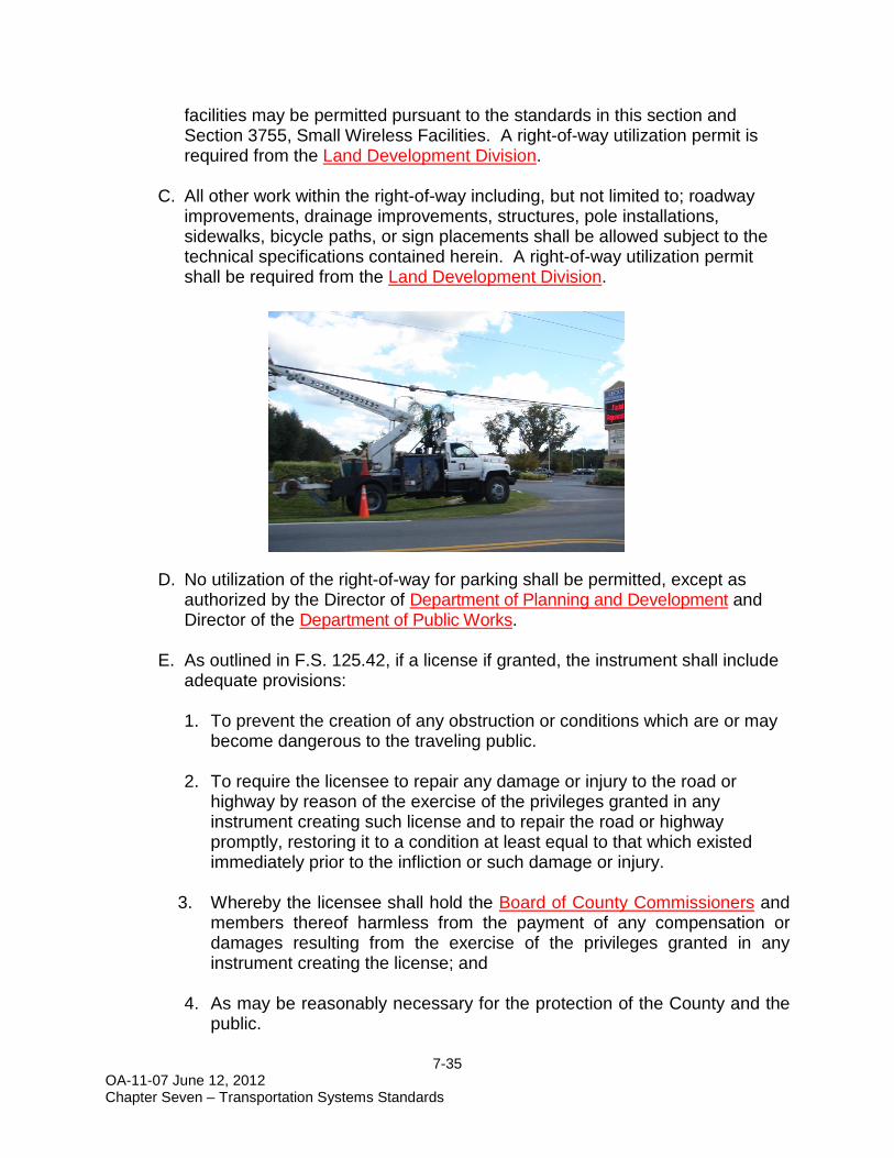
C. All other work within the right-of-way including, but not limited to; roadway
improvements, drainage improvements, structures, pole installations, sidewalks, bicycle paths, or sign placements shall be allowed subject to the technical specifications contained herein. A right-of-way utilization permit shall be required from the Land Development Division.
D. No utilization of the right-of-way for parking shall be permitted, except as
authorized by the Director of Department of Planning and Development and Director of the Department of Public Works.
E. As outlined in F.S. 125.42, if a license if granted, the instrument shall include adequate provisions: 1. To prevent the creation of any obstruction or conditions which are or may
become dangerous to the traveling public.
2. To require the licensee to repair any damage or injury to the road or highway by reason of the exercise of the privileges granted in any instrument creating such license and to repair the road or highway promptly, restoring it to a condition at least equal to that which existed immediately prior to the infliction or such damage or injury.
3. Whereby the licensee shall hold the Board of County Commissioners and members thereof harmless from the payment of any compensation or damages resulting from the exercise of the privileges granted in any instrument creating the license; and
4. As may be reasonably necessary for the protection of the County and the
public.

7-36 OA-11-07 June 12, 2012 Chapter Seven – Transportation Systems Standards
It is the intent of the Board of County Commissioners that if adequate provisions are not provided to meet the concerns outlined, at their sole discretion, a license may be denied. The phrase "As may be reasonably necessary for the protection of the County and public" is defined to mean any matter concerned with the granting of the license which might affect the public health, safety, and welfare, including, but not limited to, concern with road safety, the environmental effects of the utility being placed in the right-of-way, and its effects on the surrounding area, whether the license being granted conflicts with the County's or the region's overall plans for the provision of utility services, and other matters of similar concern. The burden of proof or disputing these findings shall be on the person(s) and/or corporation requesting the license.
F. INSURANCE: A Certificate of Insurance is required to be submitted at the
time of ROW Utilization Application submittal. The insurance required is as follows: Commercial General Liability
1. Contractor must obtain an occurrence form policy in limits not less than
$1,000,000 each occurrence, $1,000,000 products/completed operations each occurrence, $1,000,000 personal and advertising injury liability and $5,000 medical expense.
Automobile Liability 1. Contractor must obtain coverage for all vehicles for Bodily Injury and
Property Damage of not less than $1,000,000 combined single limit each accident. In the event the Contractor does not own vehicles, the Contractor shall maintain coverage for Hired & Non-Owned Auto Liability, which may be stated by way of endorsement to the Commercial General Liability policy or separate Business Auto Liability policy.
Citrus County, Florida, a political subdivision of the State of Florida, its officials, employees and volunteers are to be covered as an Additional Insured on all policies. The coverage shall contain no special limitation on the scope of protection afforded to the County, its officials, employees or volunteers. The Certificate Holder should read as follows: Citrus County, Florida, a political subdivision of the State of Florida, 3600 W. Sovereign Path, Lecanto, FL 34461.

7-37 OA-11-07 June 12, 2012 Chapter Seven – Transportation Systems Standards
Workers’ Compensation and Employer’s Liability 1. Contractor must obtain Workers Compensation insurance with limits in
compliance with applicable state and federal laws; if any operations are to be undertaken on or about navigable waters, coverage must be included for the US Longshoremen & Harbor Workers Act. Employer's Liability should be for not less than $100,000 each accident, $500,000 disease policy limit and $100,000 disease each employee must be included.
G. MAINTENANCE BOND - In accordance with the Citrus County Land
Development Code, any installation, construction or modification of County infrastructure by those companies, communities, organizations, or groups shall: 1. Enter into an Interim Maintenance Agreement with the County for the
maintenance and repair of the work for a period of time as agreed upon.
2. Post a maintenance bond in an amount established within this Land Development Code.
The project engineer shall notify the Director of the Department of Public Works in writing requesting final inspection for perpetual maintenance by the County. If the County Engineer should deem the work and condition of the infrastructure to be sound and in good operating condition, the County Engineer shall recommend such work be accepted for perpetual County Maintenance by the Board of County Commissioners.
H. Approval of a landscaped median within the right-of-way shall be subject to the following criteria:
1. The creation of a median shall be through the platting process, shall be
dedicated, and labeled as a landscaped tract.
2. The median area shall not be included within the dimension used to determine the minimum right-of-way width.
3. All landscaping within the median must comply with the Clear Visibility
Triangle requirements of this chapter.
4. The developer shall be responsible for the creation of a homeowner's association. The developer/homeowner's association shall be responsible for the maintenance and upkeep of the median.

7-38 OA-11-07 June 12, 2012 Chapter Seven – Transportation Systems Standards
I. Exemptions:
1. The County’s departments or agencies under contract to the County, as authorized by the BCC.
2. Approved US Postal Service mail boxes or newspaper delivery
receptacles with a support system as follows: Metal or concrete supports not exceeding 10 square inches; or wooden supports not exceeding 20 square inches. The support systems shall be in accordance with the U.S. Postal Service requirements and FDOT roadside safe zone requirements.
3. Roadside Safety Memorial Markers, permitted by the Citrus County
Department of Public Works. 7330. VACATIONS OF RIGHTS-OF-WAY
Applications to vacate a right-of-way shall be approved upon a finding that ALL of the following requirements are met:
A. The requested vacation is consistent with the Multimodal Transportation
Element of the Comprehensive Plan.
B. The right-of-way does not provide the sole access to any property. Remaining access shall not be by easement.
C. The vacation would not jeopardize current or future location of any public or
private utility.
D. The proposed vacation is not detrimental to the public interest and provides a positive benefit to the County.
7340. GATED ENTRANCES
In the interest of protecting public health, safety, and welfare of all vehicle drivers, and yet allow communities to control access within defined boundaries, the following standards are established concerning gated entrances:
A. Gates shall be set back 20’ from the roadway edge of pavement, or twice the
length of the longest vehicle to regularly use the roadway. See figure below for schematic of gated roadway.
B. Gates shall be designed to open onto private property and away from the
roadway edge of pavement. Gates shall not be permitted to obstruct the lanes of traffic, or interfere with the progression thereof.

7-39 OA-11-07 June 12, 2012 Chapter Seven – Transportation Systems Standards
C. No portion of the gate support shall be closer than 6’ from the Edge of
Pavement (EOP), or 18” from the back of a non-mountable curb (6” upright curb), if such curb extends 50’ to either side of gate. The Manual of Uniform Minimum Standards for Design and Maintenance of Streets and Highways - FDOT Florida Greenbook – shall govern gate features’ physical locations
D. All medians and associated facilities must be outside of the right-of-way.
Median widths are excluded from satisfying required right-of-way construction widths. Clear sight distance triangles must be maintained on either side of gate.
E. A sign must be posted at all intersecting roadways that states “Gated
Roadway Ahead”. This may be included within the subdivision identification sign provided it is clearly legible. For the purpose of this requirement, established FDOT signage criteria shall apply.
F. The gate and access key pad must be illuminated.
G. The gate must be opaque in nature.
H. For the purpose of emergency vehicle access, the gate must have the ability
to be opened by siren or be of breakaway design.
I. A turnaround zone shall be provided on all roadways that have gated entrances. The turnaround zone shall be large enough for SUV vehicles to turn around.

7-40 OA-11-07 June 12, 2012 Chapter Seven – Transportation Systems Standards
7350. ADDRESSING
All buildings in the unincorporated area of the county shall have their assigned building number properly displayed, whether or not mail is delivered to such building or property. It shall be the duty of the owners and occupants of each building in the unincorporated area to post the assigned building number on the property in the following manner:
The building address number shall be affixed to the front of the building, or to a separate structure in front of the building (such as a mailbox, post, wall, fence, etc.), in such a manner so as to be clearly visible and legible from the public or private way on which the building fronts.
Violations of this section may be referred to County Code Compliance. Proceedings before the Code Compliance Special Master shall be governed by its rules and procedures. It is noted that addressing must comply with the requirements of the Florida Building Code, as applicable, and where conflicts apply the Florida Building Code shall take precedence.
7400. INTERCHANGE MANAGEMENT AREAS
A. PURPOSE AND INTENT
The purpose of this section is to encourage managed, sensible interchange development by providing protective measures that promote safety, ensure compatibility with surrounding land uses, and promote highway beautification within the Interchange Management Areas (IMA) relative to the Suncoast Parkway. As such, these standards for development within the IMA are intended to further promote aesthetically pleasing developments, recognize the importance of the interchange areas as the gateway to the community, and protect the integrity and safety of the roadway through acceptable access management practices. The design of the non-residential projects should be oriented toward accomplishing consolidated access and circulation systems, and providing elements such as signage and landscaping that are unified throughout the quadrants of the interchange.
B. APPLICABILITY
1. The limits of the IMA on the interchange access roads shall be those
properties defined within one (1) mile (i.e. 5,280 feet) as measured from the end of the Suncoast Parkway interchange ramp tapers within each quadrant of the SR-44 IMA and the Cardinal Street IMA as shown in the figure below.

7-41 OA-11-07 June 12, 2012 Chapter Seven – Transportation Systems Standards

7-42 OA-11-07 June 12, 2012 Chapter Seven – Transportation Systems Standards

7-43 OA-11-07 June 12, 2012 Chapter Seven – Transportation Systems Standards
2. The standards outlined in this section are intended to be applied to development that is newly proposed for non-residential use, or an expansion of existing non-residential development within the IMA that exceeds twenty-five (25) percent of the legally permitted gross leasable area existing at the time of the effective date of this IMA Ordinance.
C. GENERAL STANDARDS
1. All new or expanded non-residential development within the IMA subject to
these standards shall be serviced by central water and central sewer facilities, and regional stormwater (when available).
2. The specific limits of any environmentally sensitive areas shall be verified and depicted in each development plan prior to approval. The intent of the IMA shall be to minimize any disturbance of all environmentally sensitive lands while providing for the reasonable use of developable property and reasonable access to the property.
3. All utility lines serving non-residential uses proposed or developed within the
IMA, including electric, telephone, data, and cable TV, shall be installed underground, except for agricultural uses. Junction boxes, transformers, and other structures essential to utility service which, due to their function, are required to be located above-ground, shall be screened from view of public rights-of-way.
4. Trash receptacles, mechanical equipment, outdoor storage, loading docks,
and other accessory uses to non-residential development shall be located or screened in such a manner as to be hidden from view of the Suncoast Parkway and interchange access road(s).
D. ACCESS MANAGEMENT
1. The use of shared, joint or cross access and interconnected parking lots and
frontage roads shall be implemented in each development plan to accomplish direct access to property within the IMA. These access features shall be designed to connect to more than one other roadway, whenever feasible, to enhance the overall accessibility of the developed area. The County may require these conditions to be recorded with the legal description of the property where cross access agreements or other applicable conditions apply. The following access requirements within the IMA shall also apply:
a) The distance to the first access connection from the ramp taper shall be
consistent with Florida Department of Transportation (FDOT) requirement for state highways, or at least 660 feet on interstate access roads that are under local jurisdiction, and should be right-in/right-out only. This distance

7-44 OA-11-07 June 12, 2012 Chapter Seven – Transportation Systems Standards
shall be measured from the end of the ramp taper for that quadrant of the interchange.
b) The County shall require a minimum driveway spacing of 660 feet where
feasible and practicable consistent with sound and generally accepted engineering practices and principles.
c) Each development plan shall provide for appropriate stub-outs to support
cross access between adjacent parcels. d) The minimum distance to the first full median opening shall be at least
1,320 feet, as measured for the end of the taper of the egress ramp. e) Any access point or median opening that does not comply with one (1) or
more provisions of this subsection may be designated as Interim Access upon approval by the Planning and Development Commission (PDC) or Department of Planning and Development Director (PDD) and Director of the Department of Public Works (DPW) based upon the requisite and competent evidence being submitted by the applicant and accepted by the County. In all cases where the access is designated as Interim Access, such access shall be specifically noted on the development plan submitted for approval. The requirement to provide subsequent alternative access shall run with the property and be a condition of development approval. The future planned alternative access shall be specifically identified. Property that is capable of being served by the future planned alternative access per determination of the PDC or DPD and DPW, shall require that the Interim Access be eliminated or altered, at the cost of the owner/applicant, and that the property utilize the new access location which is consistent with the provisions of this subsection.
2. The minimum length of driveways, or throat distance, shall vary based upon
the proposed land use for the particular parcel of land and the projected daily and peak hour traffic volumes for the proposed development on the property. The driveway throat distance shall be measured from edge of traveled way to the first internal drive. To minimize potential vehicle stacking that would present a traffic operational or safety concern on the interchange access road, the minimum throat distance for any driveway within the IMA shall be the following:
1. DRIVEWAY THROAT DISTANCE
Distance Required (Feet) Peak Hour Trips With Right Turn Lane Without A Right Turn Lane 50 or less 15 30 51 to 99 25 50 100 or more 75 150

7-45 OA-11-07 June 12, 2012 Chapter Seven – Transportation Systems Standards
E. LANDSCAPE AND BUFFERING
1. All non-residential development within the IMA shall maintain a minimum 25-foot wide, Type C, landscape buffer between the interchange access road and the land development. The landscape buffer shall be located along the interchange access road, and shall be unbroken except for required driveways, pedestrian circulation systems, and other public safety elements. Primary landscaping elements shall be chosen to reduce the scale of the adjacent interchange access road and commercial structures. Secondary landscape elements shall include formal, orderly planting beds with highly defined edges. If existing vegetation is to be preserved, a varying buffer design may be utilized where the average width is 25 feet. Alternative designs may be considered subject to approval by the Land Development Director.
2. All non-residential development within the IMA shall comply with other
landscape requirements and tree preservation standards as required by this LDC, in addition to what is specified in this Section.
3. Required landscaping for non-residential development within the IMA shall be
chosen that provides for a compatible landscape theme to enhance the “gateway” image throughout the four interchange quadrants, subject to review and consideration by the Land Development Director or designee.
F. EXTERIOR LIGHTING
Exterior lighting design within the IMA shall enhance security of pedestrians and motorists alike. All pedestrian walkways and parking spaces shall be adequately lighted through the use of individual or combination lighting features such as standard luminaire, street lamp, and/or bollard type fixtures. Lighting shall be designed according to the following standards:
1. Non-shielded exterior light sources shall not exceed 20 feet in height.
Shielded light sources may not exceed 35 feet in height. 2. All lighting shall be designed to minimize spillage onto adjacent non-
compatible land uses. Non-shielded fixtures are permitted a maximum illumination of two and one-half foot candles. Shielded fixtures are permitted a maximum illumination factor of five foot candles, and shall be full cutoff such that no light output is emitted at or above a horizontal plan drawn through the bottom of the fixture.
3. Lighting sources shall be shielded from vehicular travel lanes so that glare to motorists is minimized. Areas located on waterways, such as docks and nature trails, and other regulated areas shall utilize shielded light fixtures so that the light source is adequately shielded from view on the waterway or

7-46 OA-11-07 June 12, 2012 Chapter Seven – Transportation Systems Standards
regulated area. Lighting and other improvements shall be incorporated into the landscape design.
4. Exterior illumination shall be engineered for public safety and not impact
adjacent properties to an extent greater than is necessary to address the safety issue. Lighting plans shall be required, and extensive lighting systems shall be justified by appropriate study at the applicant’s expense.
G. PEDESTRIAN CIRCULATION
Circulation systems for development in the IMA shall be designed to support pedestrian mobility. To accomplish this, the following standards shall apply. 1. Pedestrian circulation systems shall be continuous and designed to connect
adjacent properties to each other via external sidewalks along the IMA crossroads with interconnection to recreational trails provided as part of the Suncoast Parkway where available.
a) Pedestrian ways may be constructed of paver blocks, concrete, brick, or
other suitable materials and may be incorporated into the landscape buffer.
b) Pedestrian ways that traverse parking areas shall be clearly demarcated
by the use of such materials as scored concrete, paver blocks, bricks, or other suitable materials.
2. All non-residential projects within the IMA shall include design features such
as pedestrian amenity areas, which include well landscaped sitting areas with design components such as seating elements and/or other amenities in shaded areas. Pedestrian amenities shall be commensurate with the size and scale of the development.
3. All non-residential development within the IMA shall comply with other pedestrian amenity standards as required by this LDC, in addition to what is specified in this Section.
H. SIGNAGE
Signage proposed within the IMA shall demonstrate a compatible theme design throughout the four interchange quadrants. In addition, signage shall be situated to assist directing traffic with access sharing. All signs proposed, installed, or replaced within the IMA shall conform to the standards set forth herein:

7-47 OA-11-07 June 12, 2012 Chapter Seven – Transportation Systems Standards
1. The total sign area of all signage on any one lot shall not exceed 200 square feet. A double-faced sign shall be considered a single sign. However, signage designed for pedestrian viewing only, such as under canopy signage, wall signs, or small directional signs, shall not be included in calculating the maximum allowable sign area per lot.
2. Free-standing signs shall not exceed 20 feet in height above natural grade. 3. Roof signs shall not be permitted. 4. The main supporting structure of all signs shall be set back at least 15 feet
from the edge of the right-of-way of the interchange access road. The main supporting structure of signs along the interstate highway shall be set back at least 25 feet from the edge of the interstate right-of-way.
5. Flashing, blinking, fluctuating, or otherwise changing light sources are
prohibited, except as otherwise allowable in Section 9240 of this LDC. 6. No new offsite advertising (billboards) shall be allowed in any IMA. 7. Where other specific standards for signage are not explicitly identified herein,
compliance shall be demonstrated in accordance with the sign requirements of this LDC .
I. SUBDIVISION REGULATIONS
The intent of this standard is to preserve opportunities for design of effective access and circulation systems for properties within the IMA and to avoid the creation of small lot frontages with access constraints:
1. When subdividing property within the IMA, the minimum lot frontage shall be
440 feet for any new nonresidential lot abutting the interchange access road classified as an Arterial, and the minimum lot frontage shall be 220 feet for any new non-residential lot abutting the interchange access road classified as a Collector. The depth of the newly created lot shall not exceed three times its width. Lot aggregation for purposes of proposed development plans shall be encouraged for any parcels of record that do not meet this requirement and cause adverse impacts to traffic circulation. This frontage shall not apply to properties that only obtain access from an interior road.
2. No new or additional access rights will be permitted for properties that are created as the result of parcel or lot splits except as what is allowed pursuant to the Access Management provisions of this chapter.

7-48 OA-11-07 June 12, 2012 Chapter Seven – Transportation Systems Standards
7500. AIRPORTS – ADJACENT LAND USE CONTROLS
The provisions of this section are intended to comply with the requirements of Chapter 333, Florida Statutes. Where specific standards differ, the most restrictive shall apply.
A. Airport Height Notification Zone and Regulations
1. Establishment of Zone - The Airport Height Notification Zone is hereby established to regulate the height of structures and natural vegetation for areas in proximity to the licensed public use airports located within Citrus County. The Airport Height Notification Zone, consists of three subzones, defined as follows:
a. Subzone A - The area surrounding each licensed Public Use Airport
extending outward 20,000 feet from the ends and each side of all active runways.
b. Subzone B - That area surrounding each licensed Private Use Airport
and each licensed Helipad (Public or Private Use) extending outward 4,000 feet from the ends and each side of all active runways or helipads.
c. Subzone C - That area within Citrus County that is not within Airport
Height Notification Subzone A or B.
2. Height Notification Regulations - All development proposals that are considered a potential airport obstruction within the Airport Height Notification Zone shall be forwarded to the FAA to be reviewed for conformance with the Obstructions Standards detailed in Title 14, Code of Federal Regulations, Part 77 Subpart C. (14 CFR Part 77).
a. A proposed development or use shall be determined to be a “potential
airport obstruction” if the proposed development or use would result in a structure or natural vegetation having a height greater than: 1) An imaginary surface extending outward and upward from the ends
and sides of a publicly licensed airport active runway at a slope of one-foot vertical to every 100 feet horizontal outward to 20,000 feet for Subzone A;
2) An imaginary surface extending outward and upward from the ends and sides of each licensed private use airport active runway or licensed helipad (public or private) at a slope of one-foot vertical to every 20 feet horizontal outward to 4,000 feet for Subzone B; or
3) 200 feet above ground level for Subzone C.
7-49 OA-11-07 June 12, 2012 Chapter Seven – Transportation Systems Standards
b. Applicants of any development or land use proposal determined by the County to result in a structure that constitutes a “potential airport obstruction” shall be issued a Notice of Potential Airport Obstruction during the development proposal review process by the Director of the Land Development Division, or his/her designee. 1) Single family homes that are located 3,500 feet or more from the
ends or sides of a publicly licensed airport runway are specifically exempt from the notification provided the tallest structure is 35 feet above ground level or less.
2) Single family homes that are located 700 feet or more from the ends or sides of a privately licensed airport runway or licensed helipad (public or private) are specifically exempt from the notification provided the tallest structure is 35 feet above ground level or less.
3) No proposal for development will be approved for construction and no permit for construction will be issued for any proposal to construct any structure, which is determined by the County to be a “potential airport obstruction” unless a County Construction/Use Permit is granted.
c. Any proposed development or uses which are not determined to be a
“potential airport obstruction” is exempt from any Airport Height Notification Zone permitting regulations contained herein.
3. It shall be the burden of the applicant to establish which subzone the
proposed development or use lies. This determination will be based on the submission by the applicant of the following minimum data for the “potential airport obstruction”.
a. Coordinates of structure in State Plane Coordinate System - NAD 83;
b. Ground elevation of the structure at the site expressed in mean sea
level;
c. Overall structure height expressed in both mean sea level and above ground level; and
d. Distance as expressed in feet or statute miles and direct bearing from
nearest public or private airport.
The above information should be submitted on a site plan sealed by a registered Professional Engineer (PE) or Professional Land Surveyor (PLS). This information will be submitted to the Director of the Land Development Division, or his/her designee, for review.

7-50 OA-11-07 June 12, 2012 Chapter Seven – Transportation Systems Standards
4. Construction/Use Permit Procedures and Criteria for Approval - Any applicant affected by a Notice of Potential Obstruction may apply to the Director of the Land Development Division, or his/her designee, for a Construction/Use Permit.
a. Commercial wireless telecommunication towers, structures, and
antennas shall be subject to the provisions of this section, and shall meet the maximum height limitations imposed by that section or this section, whichever is more restrictive.
b. Procedures for Obtaining a Construction/Use Permit.
1) Applicants shall submit to the Director of the Land Development
Division, or his/her designee, a completed application form (as provided by the County) and a copy of the Notice of Proposed Construction or Alterations (FAA 7460-1 form) submitted to the FAA for the project. Permit requests may be considered by the Director of the Land Development Division, or his/her designee, concurrent with development plan approval consideration. Applicant shall submit a copy of the permit application form and supporting information to the respective airports Fixed Base Operator (FBO).
2) Applicants shall submit to the Director of the Land Development
Division, or his/her designee, the final Determination issued by the FAA based on its review of the applicant’s Notice of Proposed Construction or Alteration (FAA 7460-1 form) submitted in accordance with 14 CFR Part 77.
3) A copy of the completed permit application form and supporting
project description and drawings will be forwarded to the Citrus County Aviation Advisory Board (AAB) or their designee. The AAB may review and make recommendations to the Director of the Land Development Division, or his/her designee, if the proposed structure or use impacts the Airspace Height Limitations contained in this LDC and reflected in the figure below. Should the AAB review the proposal, consideration will be given to: a) The nature of the terrain and height of existing structures. b) Public and private interests and investments. c) The character of flying operations and planned development of
airports. d) The safety of persons on the ground and in the air. e) Land use density and surrounding uses of land. f) The safe and efficient use of navigable airspace and proximity
to arrival, departure, and training patterns. g) The cumulative effects on navigable airspace of all existing
structures, proposed structures identified in the applicable

7-51 OA-11-07 June 12, 2012 Chapter Seven – Transportation Systems Standards
jurisdictions’ comprehensive plans, and all other known proposed structures in the area.
h) FAA determinations and results of aeronautical studies conducted by or for the FAA.
i) FDOT comments and recommendations, including FDOT findings relating to Section 333.025 (1) F.S. standards and guidelines.
j) Other testimony and findings of aviation operations and safety experts.
No permit shall be approved solely on the basis that such proposed structure will not exceed federal obstruction standards as contained in 14 CFR Part 77, or any other federal aviation regulations.
c. Criteria for Granting a Construction/Use Permit - Following consideration of review criteria and procedures provided herein, a Construction/Use Permit may be issued for a period not to exceed 18 months, with one additional 18 month extension, upon written justification.
B. Airspace Height Limitations
1. Public Use Airports - In order to protect the airspace of public airports the
following airport imaginary surfaces and their associated height restrictions are hereby created and established. An area covered by more than one of the described imaginary surfaces is considered to be in the surface with the more restrictive height limitation.

7-52 OA-11-07 June 12, 2012 Chapter Seven – Transportation Systems Standards
(Note – this figure is a representation of a three-dimensional figure that is on file with the County Surveyor's office in the Department of Public Works).
a. Primary Surface: The surface area longitudinally centered on each
runway, extending to the end of that runway and with the width so specified for the most precise approach existing or planned for either end of the runway. The elevation of any point on the primary surface is the same as the elevation of the nearest point on the runway centerline. Within the primary surface, no structures will be permitted that are not a part of the landing and takeoff area or facilities and has a greater height than the nearest point on the runway centerline. The width of the primary surface shall be as follows: 1) 250 feet for utility runways having visual approaches only.
2) 500 feet for utility runways having nonprecision instrument
approaches. 3) For other than utility runways, the width is:
a) 500 feet for visual runways having only visual approaches.
Airspace Height Limitation Zones

7-53 OA-11-07 June 12, 2012 Chapter Seven – Transportation Systems Standards
b) 500 feet for a nonprecision instrument runway having a visibility minimum greater than three-fourths of a statute mile.
c) 1,000 feet for a nonprecision instrument approach with a visibility minimum as low as three-fourths of a statute mile and for precision instrument runways.
At those airports having defined runways with specially prepared hard surfaces, the primary surface for such runways extends 200 feet beyond each end of the runway hard surface and the approach surface begins at that point.
b. Transitional Surface: These surfaces extend outward and upward at
right angles to the runway centerline and the runway centerline extended at a slope of 7:1 from the sides of the primary surface and approach surfaces. Transitional surfaces for those portions of the precision instrument approach surface that project through and beyond the limits of the conical surface extend a distance of 5,000 feet horizontally from the edge of the approach surface and at right angles to the runway centerline. No structure shall be allowed to penetrate the transition surface.
c. Horizontal Surface: A horizontal plane 150 feet above the established
airport elevation, the perimeter of which is constructed by swinging arcs of specified radii from the center of each end of the primary surface of each runway of each airport and connecting adjacent arcs by lines tangent to those arcs. The radius of each arc is: 1) 5,000 feet for all runways designated as utility or visual approaches
only. 2) 10,000 feet for all other runways.
The radius of the arc specified for each end of a runway shall have the same arithmetical value. That value will be the highest determined for either end of the runway. When a 5,000-foot arc is encompassed by tangents connecting two adjacent 10,000-foot arcs, the 5,000-foot arc shall be disregarded. No structure will be permitted in the area encompassed by the horizontal surface that is higher than 150 feet above the established airport elevation.
d. Conical Surface: A surface extending outward and upward from the
periphery of the horizontal surface for a distance of 4,000 feet at a slope of 20:1. Height limitations for structures in the conical zone are 150 feet above the established airport elevation at the inner boundary of the zone with the permitted height increasing one-foot vertically for every 20 feet of horizontal distance outward from the inner boundary of the zone to a height of 350 feet above the established airport elevation at the outer boundary of the zone.

7-54 OA-11-07 June 12, 2012 Chapter Seven – Transportation Systems Standards
e. Approach Surface: A surface longitudinally centered on the extended runway centerline and proceeding outward and upward from each end of the primary surface. The width and height of the approach surface is the same at the inner boundary as the primary surface it adjoins and expands uniformly to a width of: 1) 1,250 feet for that end of a utility runway with only visual
approaches. 2) 1,500 feet for that end of a runway other than a utility runway with
only visual approaches. 3) 2,000 feet for that end of a utility runway with a nonprecision
instrument approach. 4) 3,500 feet for that end of a nonprecision instrument runway, other
than utility, having a visibility minimum greater than three-fourths of a statute mile.
5) 4,000 feet for that end of a nonprecision instrument runway, other than utility, having a nonprecision instrument approach with a visibility minimum as low as three-fourths of a statute mile.
6) 16,000 feet for precision instrument approach runways. The approach surface extends outward and upward for a horizontal distance of: a) 5,000 feet at a slope of 20:1 for all utility and visual approach
runways. b) 10,000 feet at a slope of 34:1 for a nonprecision instrument
runways other than utility. c) 10,000 feet at a slope of 50:1 with an additional 40,000 feet at a
slope of 40:1 for all precision instrument runways.
Height limitations within the approach surface are the same as the height of the runway end at the inner boundary and increase at the rates shown above and will control all future construction or natural growth. On existing runways where thresholds have been displaced and threshold lights have been moved along the runway from the runway end; if any of the area between the threshold lights and red end lights is being used for either landing or takeoff of aircraft, then the approach surface would start at the end of the runway for control of future obstructions.

7-55 OA-11-07 June 12, 2012 Chapter Seven – Transportation Systems Standards
2. Private Use Airports - In order to protect the airspace of private airports, the following airport imaginary surfaces and their associated height restrictions are hereby created and established.
a. Primary Surface: The surface area longitudinally centered on each
runway, extending to the end of that runway. For private airports, the width of the primary surface shall be 250 feet. The elevation of any point on the primary surface is the same as the elevation of the nearest point on the runway centerline. At those airports having defined runways with specially prepared hard surfaces, the primary surface for such runway extends 200 feet beyond each end of the runway hard surface and the approach surface begins at that point. Within the primary surface, no structures will be permitted that are not a part of the landing and takeoff facilities and has a greater height than the nearest point on the runway centerline.
b. Approach Surface: A surface longitudinally centered on the extended
runway centerline and proceeding outward and upward from each end of the primary surface. The width and height of the approach surface is the same at the inner boundary as the primary surface it adjoins to and expands uniformly to a width of 1,250 feet for that end of a utility runway with only visual approaches. The approach surface extends outward and upward for a horizontal distance of 5,000 feet, at a slope of 20:1, for all utility and visual approach runways. No object shall penetrate the approach surface; however, only the first 4,000 feet of the approach surface (starting from the runway end) are protected for private airports.
c. Lateral Surface: This surface extends outward from the primary
surface and approach surface at right angles to the runway centerline, for a distance of 2,000 feet to each side of the runway centerline. The lateral surface, which is intended to protect the aircraft traffic patterns, is at 50 feet above the established airport elevation. No structures should penetrate the lateral surface.
3. Public and Private Use Helipads
a. Final Approach and Takeoff Area (FATO) Surface: The FATO surface
is centered and graded such as to provide a smooth surface around the established elevation of a designated helipad. A FATO surface may have any shape provided that its least dimension, i.e. length, width, or diameter, is not less than 1.5 times the overall length of the largest (longest and/or widest) rotorcraft anticipated to use the facility. No object shall penetrate the FATO surface.

7-56 OA-11-07 June 12, 2012 Chapter Seven – Transportation Systems Standards
b. Approach/Takeoff Surface: A helipad must have at least one approach/takeoff surface, conforming to the standards of 14 CFR Part 77. An approach/takeoff surface is centered on each designated approach/takeoff path, and extends outward and upward from the FATO surface. The width and height of the approach/takeoff surface is the same at the inner boundary as the FATO surface and expands uniformly to a width of 500 feet for visual approaches. The approach/takeoff surface extends outward and upward for a horizontal distance of 4,000 feet at a slope of 8:1. No objects shall penetrate the area defined by this surface.
c. Helipad Transitional Surface: These surfaces extend outward 250
feet, at right angles, to the centerline of the approach/takeoff path(s) of a helipad for visual approaches. The helipad transitional surfaces extend upward at a slope of 2:1 from the sides of the FATO surface and the approach/takeoff surface(s). No objects shall penetrate the area defined by this surface.
4. Other Areas
In addition to height limitations imposed in this section, no structure will be permitted that exceeds 500 feet above the established airport elevation within three nautical miles of the established reference point of any airport covered by this section, and no structure will be permitted within the County that would cause any hazard to airspace, as determined by the FAA.
C. Airport Land Use Restrictions
1. Notwithstanding any other provisions of this section, no use may be made
of land or water within Citrus County in such a manner as to interfere with the operation of an airborne aircraft. The following special requirements shall apply to each permitted use:
a. No lights or illuminations used in conjunction with streets, parking,
signs, or use of land and structures shall be arranged or operated in such a manner that exceeds the Airspace Height Limitations of this section, or otherwise resembles airport approach lighting that could be misleading or dangerous to aircraft operating from a public airport or in the vicinity thereof.
b. No operations from any use shall produce smoke, glare, or visual
hazards within three statute miles of any usable runway of a public airport.

7-57 OA-11-07 June 12, 2012 Chapter Seven – Transportation Systems Standards
c. No operations from any use in the County shall produce electronic interference with navigation signals or radio communications between an airport and an aircraft.
d. No Solid Waste Disposal Sites shall be permitted to be located as
follows:
1) Within 10,000 feet from the nearest point of any runway used or planned to be used by turbine powered aircraft at any publicly licensed airport or
2) Within 5,000 feet from the nearest point of any runway used only by
piston type aircraft at any publicly licensed airport or
3) So that it places the active runways and/or approach and departure patterns of an airport between the solid waste disposal site and bird feeding, water, or roosting areas.
2. Notwithstanding the preceding provisions of this section, any structure
over 150 feet above ground level must be lighted with shielded white strobe lights which operate on a 24-hour, seven-day a week/continuous schedule.
D. Nonconforming Uses
The regulations and restrictions prescribed in this section shall not be construed to require removal, lowering, or other change or alteration of any structure or natural growth not conforming to the regulations as of the effective date hereof, or otherwise interfere with continuance of such nonconforming use, except as provided in this section. However, no preexisting nonconforming structure, natural vegetation, or use shall be replaced, rebuilt, altered, or allowed to grow higher, or to be replanted, so as to constitute an increase in the degree of nonconformity with the regulations of this LDC.
E. Administration
1. The Director of the Land Development Division, or his/her designee, shall
maintain a detailed zoning map showing the Airspace Height Limitation surfaces for each State licensed airport and State licensed helipad in Citrus County covered by this section.
2. If, in the opinion of the Director of the Land Development Division, or
his/her designee, there is a possibility that issuance of any Development Permit or Development Order, although appearing to be in compliance with this section, might or could be a hazard, it shall be the responsibility

7-58 OA-11-07 June 12, 2012 Chapter Seven – Transportation Systems Standards
of the Director to forward a copy of such request to the AAB. Such recommendation may be provided by AAB staff, retained consultant, or the AAB by majority vote.
F. Variances
No variances from the provisions of this section may be granted unless the request satisfies the criteria of this LDC to justify granting of a variance. In addition, prior to granting of any such requested variance, the Department of Planning and Development shall require that the applicant furnish a copy of the requested variance to the AAB to respond with its written comments on the request for a variance.
Any such variance or development permit approval granted by the Director of the Land Development Division, or BCC, may be so conditioned as to require the owner of the development project, structure, or use in question to install, operate, and maintain such markers and lights as may be necessary to indicate to pilots the presence of airspace hazard.
7600. ROAD DESIGN 7610. GENERAL ROADWAY CONSTRUCTION STANDARDS
A. Design Vehicle Selection
1. For purposes of geometric design, the design vehicle shall be selected with dimensions and minimum turning radii larger than the majority of all other vehicles in its specific class. Design vehicles are listed in the "Florida Green Book" and AASHTO.
2. If the total number of vehicles in a particular class meets or exceeds five
(5%) percent of the total traffic the higher and more restrictive class should be used as a design control (trucks are a prime example).
3. The decision related to selecting a design vehicle should be based on
careful engineering study and a reasonable educated estimate of the type of situation and volume of expected traffic as the design vehicle selection affects, but is not limited to, the following roadway design criteria:
a. Control Radii - turning and intersection radii
b. Driveway Geometry
c. Horizontal and vertical clearance
d. Intersection sight distance

7-59 OA-11-07 June 12, 2012 Chapter Seven – Transportation Systems Standards
e. Lane width on curves
f. Maximum grades
g. Median opening widths
h. Pavement design
i. Return Radii
j. Roadway centerline alignment
k. Shoulder width requirements
l. Stopping Sight Distance
m. Vertical and horizontal Curves
B. Design Speed
1. The design speed of local and collector roadways is an extremely important parameter in establishing the geometric design criteria for these types of facilities. The proper design speed selection is central to establishing a safe and efficient environment for drivers, pedestrians and bicyclists on any given roadway.
2. According to FDOT Manual of Uniform Minimum Standards for Design,
Construction and Maintenance for Streets and Highways, the primary basis for selecting design speed should be a rational prediction of the probable maximum operating speed (by approximately 85 percent of the vehicles) on the road. Design speed is defined as the maximum safe speed that can be maintained over a given section of roadway or highway when weather, light, and traffic conditions incline the design features of the roadway to govern.
3. The Minimum design speeds for local roads and collectors shall not be
more than the values shown in the following table unless approved by the County Engineer, or his designee:

7-60 OA-11-07 June 12, 2012 Chapter Seven – Transportation Systems Standards
TABLE 7-2
MINIMUM DESIGN SPEEDS
Road Type Minimum Design Speed
Local Urban Roads (2 lane Undivided) 30 MPH
Urban Collectors (2 Lane Undivided) 40 MPH
Urban Collectors (2 Lane Divided) 45 MPH
Urban Collectors (4 Lane Divided) 45 MPH
Local Rural Roads (Undivided) 30 MPH
Rural Collectors (2 Lane Undivided) 40 MPH
Rural Collectors (2 Lane Divided) 50 MPH
4. Design speed is used to determine the geometric design features of a roadway, and is established by considering the topography, future operating speed, adjacent land uses, and the projected functional classification of the road. Local subdivision roads may be designed in a way to effectively reduce the operating speed, as long as proper sight and stopping distances are provided.
C. Soil Investigation for Collector Roadways (Major, Minor)
1. General Requirement
A geotechnical engineer, licensed in the State of Florida, shall prepare and submit for review an original signed and sealed soil investigation report. Such a report shall conform to the requirements of FDOT’s Soils and Foundation Manual, except as noted. This report shall be submitted for review and approval with the roadway plans and shall include the following, at a minimum:
a. Groundwater
Seasonal high water elevation and boring locations shall be shown on the plan and profile sheets.

7-61 OA-11-07 June 12, 2012 Chapter Seven – Transportation Systems Standards
b. Soil Classification
The soil classification for each stratum shall be identified in accordance with AASHTO M 145-73. The soil classification testing shall conform to FDOT’s Soils and Foundation Manual. Test borings shall be taken to a minimum depth of 8.0 feet below the existing grade. Borings shall be at a maximum of two hundred (200) foot intervals for undivided roadways; or at one hundred (100) foot intervals, and staggered, for divided roadways. There shall be no less than one (1) boring per street. Additional borings shall be taken as necessary to determine the accurate limits of unsuitable material. Depth and horizontal limits of muck areas shall be determined and shown on the construction plans. Unsuitable material shall be removed and replaced in accordance with FDOT Design Standards 500 and 505.
7620. ROAD GEOMETRY
A. Longitudinal Grade
All streets must have a minimum longitudinal profile grade of (0.30%) or 0.30 of 1.0%, unless otherwise approved by the County Engineer.
B. Roadway Transitions and Tapers
When through lanes are made to transition from one type of roadway to another, the required deflection angles, transition lengths and tapers shall be designed per FDOT Standard Indexes. The “Minimum Under Restraint” table shall not be used for transitions on new roadways.

7-62 OA-11-07 June 12, 2012 Chapter Seven – Transportation Systems Standards
TYPICAL INTERSECTION DETAIL

7-63 OA-11-07 June 12, 2012 Chapter Seven – Transportation Systems Standards
C. Deflection of Through Lanes through Intersections
The maximum deflection for through lanes through intersections shall meet the requirements of the FDOT Plans Preparation Manual. The FDOT Plans Preparation Manual shall not be applicable for deflection of through lanes through intersections on County roadways.
D. Horizontal Curves
1. The minimum permitted radii (maximum degree of curvature) for rural and urban arterials and collectors should conform to the FDOT Plans Preparation Manual, latest edition. The latest edition of the "Florida Green Book" should be referenced for local roads. The minimum centerline radius for an urban subdivision street is one hundred and sixty (160) feet. The EOR shall use the appropriate engineering judgment to ensure proper sight and stopping distance needed to make safe turns. Minimum centerline radii of all roadway classifications will be based upon the design speed of the facility, with the caveats referenced in this manual.
2. Tangents between curves on all streets with a design speed above 25
m.p.h. must be at least one hundred (100) feet in length, unless otherwise approved by the Department of Public Works. No ‘S’ curves are permitted. The County Engineer may grant exception to this policy based on designs following the "Florida Green Book", to accommodate exceptional cases.
E. Super Elevation
Super-elevation rates and transition requirements shall conform to the FDOT Plans Preparation Manual.
F. Vertical Alignment
1. Criteria
The design engineer shall closely coordinate the vertical and horizontal alignments. The vertical alignment shall provide the highest sight distance possible with the use of gentle grades, as specified in this manual. The minimum design speed for vertical alignment shall not be less than 30 mph regardless of horizontal alignment constraints. The minimum standard roadway base clearance required above the Seasonal High Water Table (SHWT) Elevation for roadway base courses of one foot above SHWT.

7-64 OA-11-07 June 12, 2012 Chapter Seven – Transportation Systems Standards
MINIMUM CENTERLINE RADII AND DEFLECTION

7-65 OA-11-07 June 12, 2012 Chapter Seven – Transportation Systems Standards
2. Grades
The minimum road grade for curb sections shall be 0.30% for all local roads and collectors. Refer to the "Florida Green Book" for maximum grades. Maximum changes in grade without the use a vertical curve shall be governed by the "Florida Green Book".
PAVED APPROACH APRON (LOCAL ACCESS)

7-66 OA-11-07 June 12, 2012 Chapter Seven – Transportation Systems Standards
3. Vertical Curves
Vertical curves are required when the algebraic difference between two grades exceed the values listed in the "Florida Green Book". Vertical geometry shall ensure adequate stopping and passing sight distance by meeting or exceeding the values shown in the "Florida Green Book".
4. At-Grade Intersections
The coordination of the cross sections of two intersecting roadways shall be carefully analyzed; the design should insure a smooth cross slope transition between the two roads. Where applicable, connection to the Edge of pavement, rather than the roadway crown, shall be provided. Adequate drainage shall also be provided at such intersections.
G. Corner Radii
1. Sight distance shall be provided at all intersections by either providing rounded right of way lines or straight corner cuts in accordance with sight distance triangles. Rounded right of way lines at local road and collector intersections shall have a minimum twenty-five (25) foot radius or as otherwise required by traffic conditions or geometric requirements. Corner cuts shall meet or exceed the limits of the thirty-five (35) foot radius or return radius value, whichever is greater.
2. Stopping sight distance requirements shall be considered by the Engineer
of Record in the determination of the minimum right of way to be provided at roadway intersections for local roads and collectors. The Engineer of Record shall design to the sight distance requirements of FDOT Design Standard and the requirements of this section. Additional right of way may be needed to provide for sight distance at intersections with curved roadways.
3. Minimum return radii are an element of proper design and are greatly
dependent on the selection of design vehicle. The Engineer shall conform to the turning movement requirements of the design vehicle in consideration for the intersection being designed. The following are minimum requirements:
Type of
Development Road
Classification Return Radius
Residential Local 35’ Collector 50’
Commercial Local 35’ Collector 50’

7-67 OA-11-07 June 12, 2012 Chapter Seven – Transportation Systems Standards
4. Control Radii for minimum turning paths through an intersection shall conform to FDOT’s Intersection Design Guide.
7630. MEDIANS
Whenever possible, driveways shall be aligned with existing median openings. All new median openings shall provide adequate left turn storage to existing and proposed driveways and roadway intersections. The Engineer of Record shall design median openings to accommodate control radii, width of traffic separators and the skew angle of side streets, and will vary the required design to accommodate side street widths on divided side streets. Median designs shall conform to FDOT’s Median Handbook.
7640. CONCRETE CURB, GUTTER
Vertical Curb and Gutter shall conform to FDOT Standard Indexes. Vertical curbs without gutters may be used on high side of road only, and shall be constructed using 3,000 p.s.i. concrete, at 28 days, and conform to FDOT Type D. Curb end transitions are to meet FDOT Standard Indexes. The design of Valley Crossings on local streets will only be allowed on closed drainage system (curb and gutter), unless otherwise approved by the County Engineer. In no case shall concrete valley gutters be less than thirty six (36) inches in width. Valley crossings are only permitted on local roadways with sufficiently low traffic volumes as to be controlled by side street Stop Sign conditions. Valley curb shall be constructed of 3,000 p.s.i. concrete, twenty four (24) inches wide with a minimum thickness of six (6) inches at the center, a three (3) inch rise to the back of the curb and a one (1) inch rise to the edge of pavement.

7-68 OA-11-07 June 12, 2012 Chapter Seven – Transportation Systems Standards
Subdivisions having quarter acre lots or smaller, or roadways with 50’ of right-of-way shall utilize curb and gutter closed drainage, sod common areas and traversable inlets only.
7650. ROADWAY DITCHES
A. The collection of stormwater runoff should be by positive gravity means without the use of siphons, pumps, or similar devices, unless specific approval is obtained from the County Engineer.
B. Stormwater conveyance facilities include swales, ditches, channels, culverts,
storm sewers, inlets, and weirs. C. The Engineer of Record shall design all underground piping to current FDOT
standards. Ditch Bottom Type Inlets shall be constructed per FDOT Indexes, Type C, or greater. FDOT Index Type F “Modified” may be used, when necessary, with approval of the County Engineer.

7-69 OA-11-07 June 12, 2012 Chapter Seven – Transportation Systems Standards
7660. CULVERT REQUIREMENTS
A. Roadway culverts shall be fifteen (15) inch minimum; driveway pipes may be steel reinforced concrete, or corrugated metal, conforming to the latest FDOT standards.
B. Pipe easements, when necessary, shall be thirty (30) feet minimum to permit
access, maintenance, and structural integrity, unless sight specific approved by Director of the Department of Public Works.
C. Maximum length of culvert pipe between structures shall not exceed four
hundred (400) feet. D. All pipe joints shall be wrapped with approved filter fabric per FDOT
Specifications. Pipes shall be sized in accordance with FDOT Drainage Manual.
E. All culverts shall have appropriate Mitered End Sections (MES) for the type
used. F. Where shallow swales intersect deeper drainage ditches, erosion control shall
be provided by use of culvert pipes, concrete swales, mitered end section with spillways, or other suitable means.
G. Cover material over culverts in swales shall be stabilized, compacted, and
sodded to prevent erosion. H. All pipes shall undergo video examination per FDOT (TV) criteria and
recommendations. I. The proposed design of reinforced concrete mitered end sections must meet
current FDOT Standards. J. Swale cover materials shall conform to the requirements contained herein.
Splash Pads or Rip Rap with geotextile fabric shall be provided on all MES with velocities greater than 4 feet per second for a minimum 10-year 24-hour storm event. Velocities for all pipes shall be provided for review and ranges shall be kept within prudent hydraulic engineering design standards.
K. End-walls shall be 3,000 p.s.i. concrete, at 28 days, per FDOT Indexes, and
shall be used only outside the roadway clear zone recovery area.

7-70 OA-11-07 June 12, 2012 Chapter Seven – Transportation Systems Standards
7670. SIDEWALKS 7671. DESIGN STANDARD
A. When at all possible, sidewalks shall be located in the right-of-way within two (2.0) feet of the property line on all roadways. Sidewalks shall be connected to adjacent streets per ADA and FDOT standard indexes and FDOT Specifications.
B. All base material for sidewalks shall be good, clean, firm, dry, unyielding and
compacted to a modified proctor density of 98% or 95% of maximum density as determined by AASHTO T-180. Prior to installation a visual inspection shall be conducted to ensure proper formwork and base material conditions are achieved. The County Inspector may require soil density testing performed, at the sole cost of the Developer, to ensure proper compaction, if visual inspection warrants.
C. Sidewalks shall be constructed of 3,000 p.s.i. Portland Cement Concrete,
Class 1. Materials and methods of construction shall conform to the FDOT Standard Specifications for Road and Bridge Construction, latest edition. Standard thickness shall be four (4) inches, except for driveways, where the minimum thickness shall be six (6) inches with welded wire fabric. Half inch (½ inch) expansion joints shall be provided every fifty (50) feet on center for the entire sidewalk length, and construction joints shall be provided every five (5) feet on center.
D. Driveway aprons shall also include six (6) inch by six (6) inch #10 wire mesh
reinforcement or an equivalent support such as fiber mesh. A minimum sidewalk width of five (5) feet is required for residential streets. For Collectors and Arterials, please reference FDOT – Manual of Uniform Minimum Standards for Design, Construction and Maintenance for Streets and Highways, latest edition. Any alternative sidewalk material request, other

7-71 OA-11-07 June 12, 2012 Chapter Seven – Transportation Systems Standards
than concrete shall be formally submitted for approval by the County Engineer.
E. Sidewalk design and construction shall conform with the following figures for
Expansion Joint Detail, Construction Control Joint Detail, and Sidewalk Cross-Section.
7680. TRAFFIC CONTROL DEVICES, MARKINGS AND SIGNS
A. All traffic control devices, markings, and signs shall meet the Florida Manual of Uniform Traffic Control Devices (MUTCD) and FDOT Standard Indexes as applicable.
B. Private Development
Private developments shall be subject to the same general requirements listed above. Street name signs for private roads shall have the same requirements as signing for public roads, with the exception that private road background color shall be white background with green lettering.
Expansion Joint Detail Construction Control Joint Detail

7-72 OA-11-07 June 12, 2012 Chapter Seven – Transportation Systems Standards
7681. SIGNALIZATION
A. Mast arm designs shall be utilized along urban roadways with curb and gutter for the installation of traffic signals, overhead signs and advance overhead flashing school signs. Concrete or steel strain poles may be used with the approval of the Department of Public Works, at the sole discretion of the County Engineer, if one or more of the following conditions exist:
1. Intersection width would require excessively long mast arms, 2. Lack of sufficient right of way or prohibitively excessive costs for right of
way acquisition, 3. The relocation of utilities would not be cost effective, or 4. Project construction schedules would be grossly delayed due to design,
fabrication or delivery time constraints – with the understanding that the lack of advanced planning, ordering or scheduling shall not constitute a hardship under this condition.
B. FDOT latest Mast Arm, General Notes, Mast Arm Details and Pole Schedules shall be utilized and made part of the approved plan set. All designs shall be submitted for County review and approval prior to commencing construction. The terminus end of a mast arm shall extend far enough to enable a mounting signal head aligned with the center of the turn lane closest to the median or centerline markings.
C. Mast Arm design shall conform with AASHTO "Standard Specifications for
Structural Supports for Highway Signs, Luminaries and Traffic Signals" Latest Edition, FDOT Design Standards and FDOT Standard Specifications for Road and Bridge Construction and any County’s Traffic Services Division

7-73 OA-11-07 June 12, 2012 Chapter Seven – Transportation Systems Standards
specifications and Standards. Approved mast arm shapes shall include one of the following:
1. Sixteen sided tapered shaft 2. Swaged step-tapered shaft 3. Tapered tubular shaft 4. Tubular shaft (constant diameter)
D. The structural design shall assume wind loading due to back plates including future left turn phases and one traffic sign. All approaches with reflective boarders shall have back plates. All signal mast arms shall include luminaries, and all signalized intersections shall include L.E.D. signals, L.E.D. countdown pedestrian signals and bicycle features, advance street name signs, and internally illuminated street name signs for all roadway approaches not serving isolated areas.
E. All signals shall include interconnected communication capabilities – Copper
or Fiber optic, as required by Citrus County’s Traffic Control Section, and the County Engineer.
7700. ROAD CONSTRUCTION MATERIALS AND SPECIFICATIONS 7710. CLEARING
All roadway rights of way shall be cleared and grubbed in accordance with FDOT Standard Specifications for Road and Bridge Construction, latest edition.
7720. MATERIALS REQUIREMENTS
A. An Independent Testing Consultant accredited by AASHTO, CMEC or FHWA approved and licensed by the State of Florida shall perform all tests specified within this manual. Citrus County may elect to observe the testing consultant performing tests in a field or testing laboratory. All soil surveys, certifications, design mixes, and test reports shall be submitted by the Engineer of Record on a timely basis.
B. Citrus County also reserves the right to perform tests, or request the
developer perform tests, as deemed necessary. Testing shall be in accordance with applicable FDOT Standard Specifications for Road and Bridge Construction (disregarding and excepting the requirements of Contractor Quality Control - CQC), special provisions and supplements to the FDOT Standard Specifications for Road and Bridge Construction (except for the requirements of CQC) and Technical Specifications.

7-74 OA-11-07 June 12, 2012 Chapter Seven – Transportation Systems Standards
C. Superpave asphalt is required on all new, or repaved, roads within County
jurisdiction.
D. Material suppliers shall provide proof of certification that the following items are in compliance with the requirements of this LDC and the FDOT Standard Specifications for Road and Bridge Construction (except for the Requirements of CQC):
1. Base Material 2. Prime and Tack Coat 3. Superpave Asphaltic Concrete 4. Concrete 5. Pipe (Other than Utility Pipe) 6. Pavement Markings (Striping)
E. The Engineer of Record shall submit all material certifications to the County on a timely basis for review and prior to final acceptance of construction.
7730. SUBGRADE, BASE COURSE, SURFACE COURSE
A. Design Considerations
The following design requirements shall be taken into account during the design and construction process:
1. The Engineer of Record shall sign and seal, and submit for review and
approval, all technical specifications for use with pavement design prior to use on a project.
2. Any in-place soil below the proposed base having been designated as a
Group Classification of A-2-5, A-2-6, A-2-7, A-4, A-5, A-6, A-7 and A-8 shall be removed and replaced with suitable material in accordance with

7-75 OA-11-07 June 12, 2012 Chapter Seven – Transportation Systems Standards
the depths and limits shown in the latest edition of the FDOT Design Standard Index.
3. For Design Criteria on Roadway Base Clearance and Low Edge of
Pavement Elevation refer to Chapter 6, Stormwater Management. 4. The Engineer of Record shall submit all proposed mix designs that are to
be utilized on a project prior to production and placement of the said material for review and approval. The Engineer of Record is to provide a copy of the approved mix designs to the County inspector assigned to the specific project.
5. During construction all material certifications and approved mix designs
are to be submitted on a timely basis and in accordance with FDOT Standard Specifications for Road and Bridge Construction (except for the requirements of CQC) by the Engineer of Record for review, and for the maintenance of Record Drawings.
6. The County Engineer or his designee may require further testing or a
higher structural number for non-typical pavement design situations, at his sole option.
B. Stabilized Subgrade for Flexible Pavement
Stabilized subgrade shall meet the requirements of the FDOT Standard Specifications for Road and Bridge Construction (not including CQC requirements) and the County’s Roadway Cross Sections provided herein.
C. Base Courses for Flexible Pavement
All base courses shall meet the general requirements of the FDOT Standard Specifications for Road and Bridge Construction (except for the requirements of Contractor Quality Control) and FDOT Design Standards as well as the specific specification requirements for each particular type of base course to be used. Base course materials approved for use are as follows:
• Asphalt. • Crushed Concrete, • Limerock, • Recycled Asphalt Pavement (RAP) • Shell
1. In no case shall the soil bearing value or density be less than that specified in the FDOT Standard Specifications for Road and Bridge Construction (except for the requirements of CQC). The base course

7-76 OA-11-07 June 12, 2012 Chapter Seven – Transportation Systems Standards
thickness for each road classification shall not be less than those specified in the County’s Roadway Cross Sections.
2. Limerock Base shall meet the requirements of Section 200 of the FDOT
Standard Specifications for Road and Bridge Construction (not including the requirements for CQC).
3. Shell Base shall meet the requirements of the FDOT Standard
Specifications for Road and Bridge Construction (except for the requirements of CQC).
4. Asphaltic Concrete Base - Type B-12.5 Asphaltic Concrete shall meet the
requirements of the FDOT Standard Specifications for Road and Bridge Construction (except for the requirements of CQC).
5. Recycled Asphalt Pavement (RAP) Base shall meet the requirements of
FDOT Standard Specifications for Road and Bridge Construction (except for the requirements of CQC).
D. Structural Courses for Flexible Pavement
1. Structural courses for flexible pavements shall be Type SP Superpave Asphaltic Concrete. The requirements of the latest revisions of the FDOT Standard Specifications for Road and Bridge Construction shall be met (except for the requirements of CQC). Incidental items such as prime and tack coats shall conform to the FDOT Standard Specifications for Road and Bridge Construction (except for the requirements of CQC). The design mix for Asphaltic Concrete shall be prepared by an accredited testing laboratory (CMEC, AASHTO or FHWA Approved in the State of Florida) and conditionally verified by the FDOT Central Bituminous Laboratory or its designee prior to use in the field.

7-77 OA-11-07 June 12, 2012 Chapter Seven – Transportation Systems Standards

7-78 OA-11-07 June 12, 2012 Chapter Seven – Transportation Systems Standards

7-79 OA-11-07 June 12, 2012 Chapter Seven – Transportation Systems Standards
MINOR COLLECTOR – TYPICAL SECTION

7-80 OA-11-07 June 12, 2012 Chapter Seven – Transportation Systems Standards
MAJOR COLLECTOR - TYPICAL SECTION

7-81 OA-11-07 June 12, 2012 Chapter Seven – Transportation Systems Standards
MULTI-LANE ROADWAYS TYPICAL SECTION

7-82 OA-11-07 June 12, 2012 Chapter Seven – Transportation Systems Standards
2. Structural courses shall meet the following minimum thickness of the roadway cross sections.
3. It is recommended that on multiple lift structural courses, the top structural
lift of Asphaltic Concrete shall be laid in accordance with the latest FDOT criteria.
4. Valid plant assignment sheets are to be submitted by the EOR to the
County prior to commencing production. Testing frequencies during production shall be in accordance with this manual.
E. Friction Course
All proposed friction courses shall meet the requirements of the FDOT Flexible Pavement Design Manual, the FDOT Standard Specifications for Road and Bridge Construction.
7740. PAVEMENT
Pavement design for new construction shall be in accordance with the criteria set forth in FDOT’s Flexible Pavement Design Manual with the following exceptions: A. The Required Structural Number (SN) for any pavement design shall not be
less than 2.3 for local or residential roads and shall be 2.5 or greater for all other classifications of roadways. The County Engineer may require a greater structural number for Arterials and heavy truck volumes.
STANDARD CUL-DE-SAC

7-83 OA-11-07 June 12, 2012 Chapter Seven – Transportation Systems Standards
B. The structural coefficient for calculation purposes of any Class II Crushed
Concrete to be used in a proposed base shall not exceed 0.18 per inch.
C. The structural coefficient for Recycled Asphalt Pavement (RAP) Base having a minimum LBR of forty (40) shall not exceed 0.08 per inch. A copy of the LBR test results shall be submitted when using the 0.08 layer coefficient for a proposed RAP base.
D. The use of a PG Binder may permit for the omission of ground tire rubber requirements from friction courses.
E. Equivalent AC grades of asphalt may be used in lieu of PG binders.
F. Reliability factor (%R) for new construction on local roads shall not be less than 80.
G. The EOR shall submit a signed and sealed flexible pavement design report with sufficient documentation, which includes but not limited to calculations, plan sheets, documentation of any variances or coordination with local municipalities, design high water elevation (DHW), projected Design Year AADT, Design Year 18-kip (Equivalent Single Axle Loads) ESALD calculations, LBR test results and a quality control checklist, for review and approval.
H. Rigid (Portland Cement Concrete) pavement designs will be reviewed for
approval by the County Engineer on a case-by-case basis.
I. Any variance of pavement design or materials not conforming specifically to the guidelines set forth herein or the FDOT Flexible Pavement Design Manual shall require a prior written approval from the County Engineer.
7750. OTHER SURFACE MATERIALS
A. Portland Cement Concrete Pavement
Concrete pavement design for new construction shall be in accordance with the criteria as set forth in the FDOT Rigid Pavement Design Manual. Concrete pavement shall meet the requirements of the FDOT Standard Specifications for Road and Bridge Construction (except for the requirements of CQC) and FDOT Design Standards 287, 305 and 505.
B. Architectural Pavers
Architectural Pavers may be used subject to the approval of the County. The developer or his authorized representative shall submit for approval

7-84 OA-11-07 June 12, 2012 Chapter Seven – Transportation Systems Standards
manufacturer’s literature and technical specifications regarding the structural strength, skid resistance, and subgrade requirements per FDOT Standard Specifications for Road and Bridge Construction (except for the requirements of CQC). Architectural pavers shall only be used on roads with design speeds less than 35 mph.
C. Stamped Asphalt
Stamped asphalt may be placed on residential roads, crosswalks in subdivisions, subdivision entrances, sidewalks and driveways. The asphalt surface layer shall have a minimum thickness of 1.5 inches consisting of the appropriate type mixture that meets County design standards. Stamped asphalt utilized on sidewalks shall meet the latest ADA standards. The contractor performing the work shall be an experienced applicator of stamped asphalt for a period of not less than 2 years. All stamped asphalt shall be constructed and maintained by the subdivision association. Stamped asphalt replaced by County forces will be replaced with standard county asphalt pavement.
7760. UTILITY CONSTRUCTION
For new construction utilities (including but not limited to water, sanitary sewer, telephone, gas, electric, phone, cable), and stormwater management system components that involve roadway crossings should be completed prior to construction of roadway base material.
Prior to construction of a roadway, a typical utility corridors drawing, see example below, shall be provided for review by the County.

7-85 OA-11-07 June 12, 2012 Chapter Seven – Transportation Systems Standards
For repair of existing roadways due to utility construction, the roadway repair details at the end of this chapter shall be used.
7770. GRASSING AND MULCHING
A. Ground cover, and sod, shall be planted and maintained on all disturbed areas prior to issuance of a Letter of Certification for residential or commercial sites and prior to passing final inspection for a subdivision.
B. Prior to County acceptance, the Developer shall maintain all right-of-way,
drainage retention areas, and drainage right-of-ways for a period of 36 months from the date of the Letter of Certification of Compliance.
7800. BRIDGES
The requirements and specifications of the FDOT Standard Specifications for Road and Bridge Construction (latest edition) are hereby incorporated into this document, for the purpose of bridge design.
7900. DRIVEWAY APRONS
A. General
Properties that access County roadways will require a driveway apron permit and construction of a driveway apron as permitted by the County Engineer or his representative. A driveway apron permit shall be required for the following: 1. New Residential and Nonresidential development

7-86 OA-11-07 June 12, 2012 Chapter Seven – Transportation Systems Standards
2. Replacement Residential Homes 3. New access to properties, whether vacant or improved, abutting a County
Roadway Where properties have multiple road frontage residential access shall be located on the county road having the lower functional classification, unless otherwise approved by the County Engineer. Residential properties abutted by both County and private roadways may access the private roadway. Existing accesses meeting the requirements of this section will not require permitting. Repairs and improvements to existing permitted access will not require new permits; however, modification to the roadside drainage pattern or widening of the existing access shall require a permit.
B. Construction
1. The driveway apron shall be constructed to meet or exceed abutting roadway improvements and shall conform to the construction standards contained herein.
2. Any damage to the County right-of-way as a result of driveway apron
construction shall be repaired in conjunction with the permit, prior to final release. For residential properties, construction and inspection of the constructed driveway apron must be completed within 30 days of the issuance of a Certificate of Occupancy. For Nonresidential properties, construction, and approval of the driveway apron shall occur prior to issuance of the Certificate of Compliance.
3. Sidewalks crossing driveways should be formed prior to driveways to
ensure ADA compliance. 4. Nonresidential Driveways shall meet the County’s current asphalt or
concrete specifications for materials design.
C. Regulations
1. All driveways shall be constructed up to and within the limits of the frontage boundary of the property for which they serve. Except where prohibited by physical constraints of the land as determined by the Division of Engineering, all driveway aprons shall be: a. Located and constructed within the right of way, b. Connected to the roadway improvements and the driveway

7-87 OA-11-07 June 12, 2012 Chapter Seven – Transportation Systems Standards
c. Positioned as nearly perpendicular to the roadway as possible. d. Provide for stormwater flow as shown on the approved apron plan.
2. Where driveway aprons are constructed, repaired, patched, enhanced, or
altered on any section of the County rights-of-way for the sole benefit of the property owner, the entire cost of the construction and maintenance shall be at the expense of the property owner of his authorized agent. Driveway aprons shall be maintained by the property owner in such a manner so as not to create a hazard.
3. Should the county determine that roadway or drainage improvements are
warranted, the County reserves the right to alter, repair, reconstruct, improve or replace the existing driveway apron at no cost to the property owner.

7-88 OA-11-07 June 12, 2012 Chapter Seven – Transportation Systems Standards
4. Driveway aprons constructed to meet the standards of this section may have special surface designs or coloring at the sole expense of the owner. Should the county or utility installation permitted by the County cut or remove the apron, repair or replacement of the apron is only required to meet County standards and any special surface design or coloring repair will be at the sole expense of the owner.
5. Residential
a. No more than one driveway apron shall be placed to serve single property tracts with (50) feet or less frontage, and no more than two driveway aprons shall be permitted for any single residential property.
b. All residential aprons shall have a minimum return radius of 15 feet or
four-foot flares and a minimum width of 12 feet at the property line.

7-89 OA-11-07 June 12, 2012 Chapter Seven – Transportation Systems Standards
Residential driveway aprons are limited to a maximum width of 24 feet at the property line. Residential driveway aprons proposed for wider than 24 feet at the property line will require construction of additional stormwater runoff compensation on the property and shall require approval from the County Engineer or his representative..
c. All residential aprons shall be a minimum of 50 feet from the edge of
pavement of intersecting roads.
6. Nonresidential
a. Access for nonresidential development shall be determined by access management standards contained herein, unless specific authorization granted by the Director of the Department of Public Works.
b. Nonresidential driveways shall not typically access local or unclassified
roads. Such access may be allowed under strict exception, provided the access roadway is improved to the access point.
c. Nonresidential aprons shall be designed in accordance with the FDOT
standards
INTEGRAL CURB & SIDEWALK DETAIL

7-90 OA-11-07 June 12, 2012 Chapter Seven – Transportation Systems Standards

7-91 OA-11-07 June 12, 2012 Chapter Seven – Transportation Systems Standards
(Ordinance No. 2013-A08, Sections 7135. (new), 7195., 7900., adopted April 23, 2013) (Ordinance No. 2016-A07, Sections 7160., 7195., 7280., adopted April 12, 2016) (Ordinance No. 2016-A14, Section 7400., adopted June 28, 2016)

7-92 OA-11-07 June 12, 2012 Chapter Seven – Transportation Systems Standards
(Ordinance No. 2017-A21, Sections 7110, 7150.B15, 7290.E, 7310, 7320.F, 7330, adopted May 9, 2017) (Ordinance No. 2018-A01, Section 7320, adopted January 23, 2018)