chapter v environmental assessment and resettlement plan 5
TRANSCRIPT
5-1
CHAPTER V ENVIRONMENTAL ASSESSMENT AND RESETTLEMENT PLAN
5.1 General
The Study recognizes the significance of the potential ecological and socio-economic impacts of the project very early in the planning process. As a result, appropriate environmental considerations were taken into account focussing on, to a large extent, the relevant physical, biological and social conditions of the Study Area including all changes anticipated before the Project commences. Information gathered was deemed essential in the planning and decision-making about project locations, design, operation, or mitigatory measures to identified issues.
At this stage of project preparation, the Study places a great importance on public participation, wherein dialogues and consultations with major stakeholders of the Project, such as local residents/communities, concerned agencies, local government units, and civil society groups were undertaken. Some of the measures recommended in this Study in order to prevent or mitigate impacts were the results of these processes. Figure 5.1 presents the environmental study area.
5.2 Present Natural Environment
5.2.1 Kaliwa River Watershed
The watershed had already undergone all forms of disturbance from logging operation, built-up area development, agroforestry as well as natural destructive force. The disturbance, however, is confined to gentle open areas where there is proximity to urban areas and cultivated upland farmlands. There are still remnants of climax forest species that were not totally harvested; the dipterocarps, namely the group of Shorea, Dipterocarpus and Parashorea, are still occupying the top and ridge areas of the watershed. There are 13 threatened wildlife species listed in the Kaliwa River Watershed (refer to Annex D of Volume V for the listing).
With the current program of the Kaliwa Watershed Rehabilitation and Management Project (KWRMP) to stop all forms of commercial logging in the remaining forest cover, the health status of this forest type would still remain high. However, the continuous harvesting of highly priced dipterocarps by poachers would be something that the local and national government should look into. Likewise, the sustainability of the KWRMP cannot be assured since the project will be terminated by 2004. If this trend continues, the entire watershed health would be at risk. It is strongly recommended to continue the similar project even after the completion of the current KWRMP.
Stretches with calm to sluggish flow generally have dense mats of filamentous blue-green algae, which give the distinctive blue-green coloration. The relatively elevated levels of phosphate enhance algal growth since phosphate is a limiting nutrient. Kaliwa River drains a portion of the Rizal watershed, which is partly
5-2
agricultural and partly urbanized. Domestic and agricultural wastes may have possibly contributed to the elevated nutrient levels.
Except for phosphate and turbidity, water quality of the Kaliwa River, in terms of chemical and physical constituents, was well below the standards set by the Department of Health’s Philippine National Standard for Drinking Water (NSDW) and the DENR’s Water Usage and Classification/Water Quality Criteria for sources of public water supplies (Class AA and A). However, in terms of bacteriological content, the river, as an open body of water, exhibited a high total coliform level, way above the standards set by DENR and DOH.
5.2.2 Kaliwa – Taytay Waterway
Using the available satellite imagery maps and information verified through site surveys, the general land uses of the area listed from the most dominant to least dominant land use are indicated below:
General Land Uses of the Kaliwa-Taytay Waterway Waterway Facility Land Use
Upper Tunnel : Open canopy, closed canopy, agricultural land (mixed fruit trees, agro-forestry species), brushland, grassland, barren land, built-up area
Water Treatment Plant and Powerhouse :
Grassland, closed canopy, agricultural land (mixed fruit trees, agro- forestry species), open canopy, built-up area, brushland
Pipeline : Built-up area, agricultural area (rice land), grassland, closed canopy, open canopy, brushland, barren land
Antipolo Waterway : Built-up area, agricultural area, grassland, closed canopy, open canopy, barren land, brushland
Taytay Reservoir : Grassland, agricultural land (mixed fruit trees, agro-forestry species, rootcrops), closed canopy, built-up area
5.2.3 Agos Dam Site and Agos Reservoir Area
The Kanan River Watershed is relatively intact and has modest pristine environment especially on the highest point elevation where headwaters are situated. Rugged terrain and inaccessibility are some of the main reasons why it has not been subject to commercial utilization. The entire Kanan River Watershed is mostly forested with small patches of grassland/savannah and agro-ecosystem areas. Riparian and streambank ecosystems are part of the main and sub-tributaries with narrow and fringe type floodplain ecosystem.
There is relatively high endemicity and 9 threatened species, which are dominated by Non-Timber Forest Product (NTFP). It is noticeable, however, that Rattan (Calamus sp.) is the most vulnerable and threatened species due to incessant wild extraction by the Dumagats which is one of their sources of income. Dumagats are the only indigenous group of people that are seen roaming the pristine dipterocarp forest in search of highly priced rattan and resin from Almaciga (Agathis philippinensis). These commodities are highly sought species due to its high demand in the market.
The watershed, however, has been subject to commercial logging operations (by small and large scale operators) during the last 30 years. Local inhabitants prefer to

5-3
cut highly priced timber from dipterocarp species like Red Lauan, Guijo, White Lauan, Narra (Pterocarpus indicus), and Mayapis (Shorea palosapis).
The threatened/vulnerable/rare plant and wildlife species observed within the Kanan system are listed in Annex D of Volume V.
5.2.4 Lower Agos and Coastal Area
Ocular assessment shows that silt accumulates at the mouth of the Agos River as the river flow is decelerated by the waves of the sea. The sand bars formed along the coast show that littoral drift or long shore currents are oriented in the southeast direction. Some of the beach structures along the coast have been damaged and were dislodged from the main beach to the surf zone. During the storm day, the sand bars are submerged and wide spread and seemed to fan out into the Pacific Ocean.
The samples obtained during the survey indicate that the coastal areas are not much affected by the incoming sediments. It may be that the coastal waters are able to disperse the fines and carry them to wider areas so that no considerable traces of these fines are found along the beaches of Infanta.
Coastal and estuarine ecosystems consist of beach vegetation, nipa stands and mangrove forest. The mangrove forest is host to a number of economically important species of trees and other plant forms. However, mangrove stand of Infanta facing Lamon Bay is 95% disturbed due to aquaculture development.
The phytoplankton and zooplankton communities living in the estuarine section of the Agos River are characterized by high diversity. This is expected since the estuarine environment is an ecotone where conditions are intermediate between freshwater and marine environments. The presence of dinoflagellates only in this river stretch signifies the contribution by the marine environment to species diversity in the area.
The estuarine environment serves as the breeding and nursing grounds of fish. Hence, estuaries are virtual feeding grounds where carnivorous fish can frequent in search of food. However, it is very few for people to frequent the area for fishing because fish is more plentiful in coastal waters. In most cases, fishing in estuaries is for home consumption. For commercial purposes, it is the source of fry and fingerlings for grow-out in fishponds.
A sandy beach borders Infanta and General Nakar. There are no indications of significant coral formations, and there exist only seagrass beds that extend to about 500 m from the shoreline. Fish species in the area caught by sustenance fishermen belong to at least ten families, which are mostly pelagic (refer to Annex D of Volume V for the list).
5.3 Anticipated Adverse Impacts and Mitigating/Enhancement Measures
5.3.1 General
Adverse impacts of the proposed project were identified for each major ecosystem: river environment, natural environment and the social environment including

5-4
resettlement. Mitigating and enhancement measures are presented following the discussion of impact identification.
5.3.2 Conceivable Issues on Natural Environment and Proposed Mitigating/Enhancement Measures
(1) Adverse Impact on Rare and Endangered Flora and Fauna Species
The preparation for the construction of dams entails an enormous spatial disturbance on the biological materials such as removal of trees and disturbance/dislocation of wildlife habitat. Activities such as construction and/or improvement of road networks and building of construction camps can also significantly affect the health of the ecosystem specific to the impacted area.
The loss of standing timber near and within the construction areas and camps is inevitable to give space to equipment pool and aggregates required for construction. Plants of other life forms near the construction site that are sensitive to dust are also in great danger as their stomata are clogged or nearly clogged thereby reducing the ability of the plant to produce carbohydrates required for their growth.
Route and road improvement to increase access to construction of tunnel and conveyance route plus erection of dams would entail complete decimation of the standing plant biomass. The removal, however, is basically confined only in areas where construction will be made. The effect on plants may be severe but since the area in question is confined, plants around the site can easily inch and creep in the open areas. Invasion through natural succession is gradual but ultimately revegetation by low-lying plants is initially completed and finally the group of shrubs and small trees follow.
Since the disturbance is only interim in nature, biological materials can easily rebound through natural succession starting from invasion of low stature plants followed by shrub typed group of plants. For immediate rehabilitation, planting species that are endemic in the area can also be employed.
During the operational phase, the following are the identified adverse impacts on the endangered flora:
Decimation and Death of Plants Due to Inundation of the Dam/Reservoir
Plants that are put underwater for a long time are subject to decimation due to inability to photosynthesize and the gradual disintegration and decomposition of plant biomass. The death is almost instant to grass, vines and other low statured plants that lack enough biomass for food storage. For trees, however, the death would be gradual due to enough food to sustain the requirements of the biomass. Other plant species that are used to riparian environment could survive and may eventually be adapted in due time. Dam height of 36 m and 165 m for Kaliwa Low Dam and Agos Dam, respectively, would definitely inundate riverine, streambank and hilly land plants.
Dipterocarps that may be affected, at least those species that are under the premium group, such as Molawin (Vitex parviflora), Narra (Pterocarpus indicus), and Banaba
5-5
(Lagerstroemia speciosa), among others, can be saved by collecting the germplasm materials. Wildlings and seeds can be collected in their natural habitat prior to starting the impounding of the reservoir. Wildlings can be directly transplanted in degraded and open areas not affected by the highest water dam level. Areas with low tree density can be subject to enrichment planting or simply allowing assisted natural regeneration to operate. Vacant spaces can be planted with more than two species to promote and maintain species diversity in the area. To assure high level of survival, wildlings, seeds, or stem cutting shall all be raised in nursery for a couple of months before out-planting. The same protocol shall also be applied for non-tree lifeforms that will be affected by inundation. This includes low statured species that are used as forage crops, source of medicinal and handicraft raw materials, among others.
Loss of Standing Biomass/Timber and Decline of Plant Biodiversity and Composition
Wanton loss and death of plants are inevitable with inundation. The death of plants under all lifeforms clearly indicates the decline of plant diversity and composition.
To maintain the level of diversity, an ex-situ protocol should be employed. This includes the transplantation of rare and endangered plant species through collection of their germplasm prior to inundation of the dam/reservoir. Establishment of a nursery or genebanks for all the selected plants that require propagation could be done strategically in the entire stretch of the dam.
To effect success of the rehabilitation/reforestation efforts, the local stakeholders shall be encouraged to be part of the activities such as co-managing the protection of the area within their jurisdiction. Rehabilitation efforts require sizeable funds and this could be provided by the proceeds of the timber harvested in the area affected by inundation. Prior to filling up of the reservoir, salvage cutting of trees with commercial height and diameter can be employed. This is to utilize the standing biomass that would only be wasted if left underwater.
Increase/Reduce Log and Other Forest Product Poaching
Navigation of the entire stretch of the dam/reservoir will be a lot easier with inundation using mechanized sea craft, if its usage is left uncontrolled. Improvement of access to the forested areas would be greatly improved and thus more people could come in. This could be an avenue for exposing precious tree volume and Non-Timber Forest Products (NTFP) to wild extraction and poaching.
This could be mitigated by deputation of Environment and Natural Resources Officers for Forest Protection (DENRO) or simply deputizing the local communities, e.g. Dumagats, to apprehend poachers. On the other hand, increased visibility of people/tourist in the area could also reduce or prevent poaching of forest products. Protection could also be enhanced by effective monitoring system of the entire watersheds by the national government through the DENR and LGUS in and around the watersheds.
5-6
Disrupt the Ecology and Productivity e.g. Nutrient Cycling of the Affected Plant Community
The death of the plants due to flooding of the reservoir will disrupt and even stop the ecological processes of the plant community thus impacting primary and secondary productivity. The removal and/or gradual death of plant materials at the edge of the reservoir would reduce the nutrient requirements of residual plants such that they have to contend to available nutrient loading from the upper forest tiered. The disruption could be permanent in nature but gradual adaptation of plants along the shorelines into riparian environment could help rebound the lost nutrient supply due to improved biomass production and consequently plant diversity.
To help improve and enhance the overall ecology of the affected plant group, restoration and rehabilitation measures shall be in order. Spaces between existing vegetation, of all lifeforms, can be planted with indigenous species in the site plus introduction of new adapted ones that require similar site quality requirements.
Reduction of Available Oxygen Underwater Thus Affecting Aerobic Dependent Organisms
Too many biomasses that are submerged in water are subject to decomposition process. The use of oxygen by plant biomass decomposers normally depletes the available oxygen thus reducing the productivity of pythomass and other aquatic resources including fish and plankton.
One practical way to reduce the depletion and/or maintain the available oxygen levels for optimal productivity is to simply harvest or conduct salvage cutting all the wood or timber biomass that can still be used either for lumber, construction of bunkhouses or simply source of fuel wood.
During site preparation and clearing, particularly along conveyance route, the removal of all standing plants of all lifeforms in each landing site and construction camp would have a direct effect on wildlife resident to the site. This disturbance could be interim in nature and will not pose a permanent damage to their biology as they easily scamper away from the impacted area.
Since the area subject to disruption is relatively small, noise disturbance can be mitigated by installing muffling devices or sound barrier to absorb and deflect sound waves.
However, during major construction activities, e.g., blasting and quarrying, the primary effect on wildlife is disturbance. Blasting results in sudden tremendous explosion that will surprise and greatly disturb the wildlife in the vicinity of the blasting area. Regular blasting will drive any wildlife within the vicinity of one-kilometer radius from the blasting site. Vibrations on the ground will also affect ground dwelling wildlife species. However, explosion and ground vibration alone do not directly threaten the lives of individual wildlife species as wildlife will learn to adjust and may ignore the disturbance created by the explosion.
Blasting as source of disturbance is only critical on the first phase of tunneling. When the tunneling activity goes below ground, the sound created by the explosion

5-7
is muffled and ground vibration is minimal as tunneling goes deeper. When tunneling is done, gradually wildlife will return to the area, as disturbance is no longer present. Directly, it is the noise created by the heavy equipment and machines in quarrying that affect wildlife.
To mitigate the effect of the first blast, trees around blasting site should not be cut, as these trees will help in muffling the sound. Also, temporary construction of “sawali” walls along the sides of the blasting site will muffle the spread of the sound. Prior to blasting, fire crackers and whistle bombs should be exploded to serve as a warning noise to the wildlife in the vicinity. This is to give time for wildlife to escape.
Microhabitat destruction will be a direct impact on wildlife followed by disturbance caused by rising water level. Due to gradual inundation process, the survival of these species is not threatened as they can easily withdraw from the rising water level. However, flooding may affect the burrows of small rodents and shrews but being very mobile animals. Accordingly, they can easily escape the inundated areas as filling up of the reservoir may take some time.
Birds and bats are not affected as these animals have ability to fly and can easily escape rising water levels. In fact, they are even provided with an advantage because of the widening of the river’s surface area. They will be provided with increased feeding and drinking areas, such as kingfishers along the banks, rails and herons. The pondage area will not only provide benefits to existing birds but will attract other species not presently recorded in the area.
To enhance and help safeguard the wildlife population, the following protection measures, among others, can be adopted: a) conduct periodic wildlife census to determine the population status of endemic, rare and endangered/threatened species. The information could be used for formulation of conservation and protection measures; b) Arrest poachers and hunters of wildlife species especially those listed under CITES II. c) Deputize local inhabitants as partners in the conservation and protection of wildlife in their own localities. d) Conduct IEC campaign in and around the watershed area on the value of animals and explain policies of the government regarding wildlife conservation.
Other potential impacts identified during the operational phase may also be experienced downstream and along the water conveyance route. The following are the projected major impacts in these areas:
Change of the Micro-habitat and Reduction of Population of Some Wildlife Species
The sudden reduction on the volume of water on the lotic ecosystem would directly impact the biology of fish and other aquatic fauna thereby affecting their ability to procreate. Similarly, plants that are adapted and growing on riparian environment would also be affected, especially on their growth and capacity to produce biomass.
To mitigate the situation, constant flow of water from dam in terms of volume and regimen should be maintained in order to provide breathing space and environment conducive for their existence.
5-8
Increase of Influence of Salinization on Estuary Environment
The significant reduction of normal streamflows of the Agos River into the estuary area would mean increasing the influence of saline environment. This may not be felt at once but would likely be an issue in the future use of the water resource. Recharge of aquifer could be contaminated with marine water intrusion due to increased estuary surface area hence affecting domestic use of groundwater. Similarly, the receding influence of fresh water would likely change and even reduce the composition of aquatic fauna.
There is no hard fast rule to reduce the invasion of marine environment in estuary area at the moment, but this could be remedied by maintaining the release of water, in terms of volume and regimen, from the dam.
The increase of space previously occupied by riparian and floodplain species can be utilized for cash crop production due to soil silty materials laden with organic nutrients. Planting of shrubs and small trees along the banks can also help stabilize the soil thus maintaining diversity of plant composition.
(2) Water Pollution in Kaliwa River Basin and Proposed Mitigating and Enhancement Measures
As earlier stated, values obtained for phosphate, total coliform and turbidity exceeded the maximum values allowed for Class A waters, indicative of contamination coming from domestic, agricultural and agro-industrial wastes. Poor sanitation condition and uncontrolled disposal may also add up to the pollution level of the Kaliwa River.
Possible mitigation to reduce the impacts would be to improve the sanitation condition of the area and to control land development.
Improvement of the sanitation condition may be undertaken by the provision of adequate sanitation facilities in areas where there is no access to sanitation. However, the sanitation program to be planned has to access other fund sources, such as the financing system developed in the 1999 JICA-DILG Study on the Provincial Water Supply, Sewerage and Sanitation Sector Plan in the Republic of the Philippines. The detailed sanitation plan/program will be drawn up after a sanitation survey has been conducted in the Kaliwa River Basin. This is to ascertain the existing sanitation facilities and to determine what type and level of treatment is required.
One possible source would be through housing improvement loans for installing in-house sanitary facilities to be instituted by the LGUs. This mechanism can be organized with the rural banks, credit cooperatives or development banks. The concerned LGU can enact local legislation establishing sanitation revolving fund. In addition, other sources can be tapped for the above purpose by establishing formal linkages with the home improvement loan facilities available through the Social Security Service, the Government Service Insurance System, and the Pag-ibig Fund. All these, however, must be coupled with proper education to encourage the people to make cleanliness and sanitation as a way of life.
5-9
Another mitigating measure is to strictly regulate the changes in the landuse of the river basin. Proposed land development must be compatible with the existing landuse plan and should not, in any way, pollute the Kaliwa River. Adequate waste treatment facilities must be instituted in any proposed development.
With the project, the generated amount of water pollution load in terms of BOD5 by the households coming from untreated wastes has minor adverse impact considering the volume of water that the reservoir holds. The degree of the contribution for water pollution of an estimated 28,000 persons living upstream of the proposed dam was estimated at about 0.24kg/ha/day. This concentration is found to be negligible as compared with the expected carrying capacity of reservoir due to its area and regular release of water.
(3) Geohazards
Natural hazards or geohazards consist of earthquake-related hazards, volcanic eruption-related hazards, flood-related hazards, landslides and typhoon winds.
Earthquake-related hazards such as earthquake landslide (only in road cuts) and flood hazards (only in the Agos River Delta) would significantly affect the environment of the Project area.
Earthquakes generate shocks or ground shaking due to the release of strained energy stored within elastic rocks by tectonic stresses. Following are the identified hazards from earthquakes and the proposed management measures (refer to Annex D of Volume V for the details):
• Ground Shaking – Adopt proper G-factor for geological condition of foundation material at the Project site or use stronger foundation material (refer also to Chapters VII and VIII for the design of the structures). After a strong earthquake, inspect structures for damages and determine if structures can be rehabilitated or be condemned.
• Ground Rupture - Set up rescue centers and local disaster management control centers. Proper type of dam infrastructure and buildings must be constructed. Structures should be sited at least five (5) m from the fault trace. Avoid construction and location of structures on or near ground-ruptured faults.
• Tectonic Deformation - Geotechnical soil/rock tests and seismic wave velocity tests indicate that the rocks having high wave velocities equal or greater than 2.5 km/sec are strong rocks/soils for foundation and construction purposes (refer to Chapter 4 for the geological assessment of the Project Area).
• Susceptibility to Liquefaction – Except for the floodplains and delta of the Agos River, no other areas within the Project are underlain by thick unconsolidated alluvium. With this finding, it follows that only such floodplains and delta have high susceptibility to liquefaction hazard. This assessment correlates well with the studies of PHILVOLCS, which show that
5-10
the Quezon Province section of the Project Area with the exception of the Agos River flood plains and delta is outside the liquefaction-prone areas.
• Landslide Hazard – Appropriate engineering measures must be adopted so as to drain the pore water, to reduce the slope to stability gradient, to armor the surface by vegetation or cement geomat or impermeable surfacing material to prevent the infiltration of rain water and surface runoff into the landslide mass, and to divert runoff flow from the landslide mass by intercepting trenches and use light weight overload materials to prevent excessive overload weight above the slip surface.
5.3.3 Conceivable Issues on River Environment and Proposed Mitigating Measures
(1) Sediment Deposit in Agos Reservoir
The sediment sources (watershed soils) for the coastal areas are the Kanan, Kaliwa and Agos Rivers. Most fines can be found in the Kanan River, which indicate that the bulk of fines may be coming from this river. The samples in the Kaliwa River did not show values for fines and indicate that the type of soil from this area will contribute lesser to minimal degree of fines. The combination of these two sources’ characteristics is shown in the Agos River source where the fines are diminished in terms of concentration. Nevertheless, the total volume of fines may be additive, considering the downstream effect of loads of fines reaching the coastal areas (refer to Annex D of Volume V for the sediment sources for the coastal areas).
For the three watersheds, the approximate volume of soil disturbed ranges from 80 x 103 to 580 x 103 m3.
From the samples obtained, the fines are negligible which may indicate that the coastal areas are not much affected by the incoming sediments. It may be that the coastal waters are able to disperse the fines and carry them to wider areas so that no considerable traces of these fines are found along the beaches of Infanta.
Total Suspended Particles
The water sample analysis reveals that during a fair weather condition there are minimal suspended particles found in the water (2 – 8 mg/l), with an average of 5.6 mg/l. However, during a stormy day, the TSS would increase to 6 to 90 mg/l, an average of 41.6 mg/l or roughly more than 8 times. During the stormy day, the Kaliwa River is the most murky and the combination of water from the Kaliwa and Kanan Rivers into the Agos River would have a reduction in concentration as less murky waters from the Kanan River dilutes that coming from the Kaliwa River. The TSS is verified near the mouth of the Agos River and was found out to be not varying. Along the coastal waters there seemed to be a steady reduction of TSS as it gets farther from the mouth. It is noted here that there is a drop to 10% TSS as compared with that at the mouth of the Agos River, indicating considerable dilution and dispersion of sediment. These observed parameters indicate that, although noticeable, the current sedimentation rate along the shore of Infanta is not very alarming. However, massive earth movement associated with the Project may reach alarming rate if not controlled properly.
5-11
(2) Reduction of River Flow in Lower Agos
The proposed impoundment of water coming from the Kaliwa and Kanan Rivers will affect the volume of water not only in the two rivers but also downstream of the dam. The areas upstream of the dam will be flooded, whereas the areas downstream of the dam will experience significant decrease in water flow especially during the dry season. Since the Kaliwa and Kanan Rivers join to form the Agos River, the impact on these rivers will vary depending on the distance from the dam.
During construction, where siltation will be the main problem, a decrease in the density of the phytoplankton, zooplankton, and fish will be observed. Although a detrital food chain is predominant in most river systems, there is a great importance of the grazing food chain in the Kaliwa-Kanan-Agos River System. Unlike other rivers where there is an abundant supply of plant detritus coming from the watershed, the Kaliwa-Kanan-Agos River System appears not to have such a supply of allochthonous materials. River stretches with sluggish flow have very minimal plant detritus, more so those stretches with fast flowing water. Instead of the usual detrital materials, mat-forming algae are dense in areas with sluggish flow in the Kaliwa-Kanan-Agos River System.
The algal food base is dependent on the quality and quantity of light penetrating the water. Once, the water becomes turbid from increased silt load, light penetration will be limited, thereby limiting the available food base of the grazing food chain. In effect, zooplankton and fish will be affected simply because they occupy the succeeding trophic levels. Hence, an ordinary increase in water turbidity, a water quality parameter, will in fact have a subsequent effect on the biological community.
Physical changes of the riverbed from gravel to silt after inundation can be expected after the construction of the dam. Such changes can be classified as habitat destruction, which will obviously affect the biological community. The distribution of organisms that is a function of their requirements for growth and their habitats provide those requirements. Hence, if the sediment will change from gravel to silt, the obvious change in particle size will favor the macro invertebrate burrowers rather than macro invertebrates living on rock surfaces and crevices where they are found. Of course, drying of some portions of the riverbed will result in a complete change of biological community from aquatic forms to terrestrial forms. Since water flow may significantly decrease during the dry season, the downstream stretches of the Agos River will be severely affected. It is also possible that marine water will enter further upstream depending on the elevation.
When the dam is operational, the impact will largely be on changes in the fish, plankton, and benthic community structures as a result of the dramatic change in habitat from a flowing water ecosystem to a standing ecosystem. The fish community will be predominated by those that are planktivorous, herbivorous, and omnivorous species simply because of the available food. Such community is different from that in a river where benthic fish species predominate because of the habitat type and available food.
5-12
Among the fish species that will be affected will be the migratory ones. Since these fish species require a freshwater habitat for growth and sexual maturity, the barrier poised by the dam will prevent the migratory species such as mullets (banak) and eels (palos) to reach the upstream sanctuary of the Kaliwa and Kanan Rivers. This break in their life cycle will obviously result in gradual extinction of the species from the Kaliwa-Kanan-Agos River Systems. Since none of the fish species identified are endemic only to this river system, the extinction may be localized, that is, only to the upper reaches. These migratory species that enter the river system will be limited to the lower reaches.
The permanent impacts of the project on the biological communities may not necessarily be a negative one. As discussed earlier, there will be a change from a riverine ecosystem to a lacustrine ecosystem. Experiences with dam operation in the Philippines showed that fish production has been favored. In some instances, the increased fish production from open water seeding by tilapia has added another alternative livelihood to the locals as in Angat Dam.
(3) Reduction of Flood Flow in Lower Agos Influencing the Mangrove Forest Ecosystem
One of the requirements for maintaining the luxuriant growth and productivity of mangrove plants is the supply of freshwater. Based on the existing tributary systems of the whole watersheds, there is no direct connection with the Agos River flow into the Infanta mangrove forest and yet, Infanta mangroves have high diversity indices and diversity per unit area. Robust growth is achieved as freshwater is supplied through open precipitation and water from small streams fed from lowland irrigation.
While there is no direct relationship between the hydrology of the Agos River and mangrove forest state of health, current situation indicates that the coastal forest really needs some restoration and rehabilitation efforts. The extensive area devoted to aqua-culture plus the threat of the community are some of those stressors that need to be addressed.
To mitigate the situation, enrichment planting of less dense part of the forest and adoption of Assisted Natural Regeneration (ANR) strategy can be employed. Abandoned fishponds shall be planted with species of Rhizophoraceae. Collected propagules can be directly planted in designated areas.
5.3.4 Emission of Greenhouse Gasses (GHG) from the Agos Reservoir
One of the adverse effects which are conceived to be caused by the creation of the Agos Reservoir is the issue on emission of greenhouse gasses (GHG). The report of the World Commission on Dams (WCD) in November 2000 states that the emission of greenhouse gasses (GHG) from reservoirs due to rotting vegetation and carbon inflows from the catchment is a recently identified ecosystem impact of storage dams. It also describes that the emissions may change significantly over time as the biomass decays within the reservoir during the first few years after impoundment, although no experience exists with minimizing, mitigating, or compensating these impacts.

5-13
Meanwhile, it was also pointed out in the International Commission on Large Dams (September 2002)1 that the vegetation biomass of a dense tropical rain forest was estimated at 270 million tons of carbon per ha and that the chemical and biochemical processes produced in the low layers of the reservoir due to the decomposition of this biomass at high temperatures leads to the formation of greenhouse gasses (CH4, CO2, H2S, etc.), one of the consequences of the de-oxygenation of the hypolimnion. It states that the best solution on the emission of greenhouse gasses is to “clear” the reservoirs area. This is what was undertaken in some reservoirs in other countries (Laos and Brazil), which were impounded in the past. Thus, it is expected that the issue on emission of greenhouse gasses is solved to a considerable extent by clearing of vegetation for the entire Agos Reservoir area.
5.3.5 Proposed Environmental Protection Measures
For the needs identified above, the following protection measures are proposed to be included as a part of the project components in the long term:
Proposed Environmental Protection Measures Proposed Work Source of Budget Entrusted to
Protection of Eco-System: (a) Transplantation of threatened and rare plants
including the establishment of a nursery or genebank
Project construction cost
LGU, DENR
(b) Re-vegetation for the areas affected by construction works, such as spoil banks, temporary facilities area
Project O&M cost LGU, DENR
(c) Forest protection by deputizing Environment and Natural Resources Officers (DENRO) and/or local communities
A fund system LGU, DENR
1
(d) Periodical wildlife census survey A fund system DENR Collaboration with KWRM Project 2
(a) Provision of subsidy to cover a part of the KWRM project cost
A fund system DENR
Measures for Mitigating Water Pollution (a) Land use management and wastewater control Coordination with
concerned agencies DENR, DILG, DOH
3
(b) Promoting the installation of community-based and/or household wastewater treatment units
A fund system LGU, DILG, DENR
A preliminary idea proposed above is to establish a special fund for these purposes, e.g., ‘Agos River Environmental Development Fund’. The fund will be managed by donation of a part of water revenue accrued from the government project (GOVw in Section F8.2 hereinafter).
This proposal is just on a conceptual stage. The mechanism on fund administration needs to be studied later when the idea has already been deliberated and accepted by major stakeholders.
1 “Impact of the Flooded Biomass on the Reservoir Water Quality During the First Years after Impounding”,
Alain Gregoire and Sandrine Richard, International Commission on Large Dams, Symposium on Reservoir Management in Tropical and Sub-Tropical Regions, September 26, 2002-Iguassu, Brazil.

5-14
A sort of legislation will be required for the establishment of the proposed “Fund.” For the purpose, It would be effective to issue a Ministerial Ordinance of DENR by which, a Committee for Fund Administration will be chartered. The Committee will be composed of stakeholders across-the-board like LGUs including NCR, Rizal, Quezon and Cavite Provinces and water distributors (Concessionaires), NGOs and MWSS or DENR as the chair agency. The function of the Committee will comprise:
1) Assurance of fund collection
2) Recovery of fund loans
3) Selection of projects for environmental preservation
4) Post evaluation/monitoring of the projects
5) Other activities required for attaining the purpose of the Fund
Or alternatively, the Inter-agency Coordination Committee for the Agos River Basin Project (ICCARBP, see Chapter XI) will carry out this function. There may be much more things to be discussed in detail in the subsequent stages.
Table 5.1 shows a tentative estimate of the proposed environmental protection measures. According to the Table, the charge to GOVw project for maintaining the Fund will be 1 centavos per cubic meter of water conveyed.
5.4 Social Environment
The social environment in the project area is a living environment composed of people, their culture and traditions, their gainful activities, and the institutions that support their way of life. The social environment is being assessed to be able to come up with a profile of the people, their communities and their socio-economic activities in order to establish mechanisms that would protect and/or restore the social environment that would be adversely affected by the project implementation. The data and findings provided in this Section will find its way into the resettlement plan, a document that would provide the policy framework and the strategies for mitigating the identified socially undesirable impacts of the Project on the potentially affected people.
5.4.1 Socio-Economic Situation of Directly Affected Areas in the Agos Dam/Reservoir
The socio-economic situation of the Barangays/Sitios of the directly affected areas in the Agos Reservoir can be best gleaned from the responses provided in the Socio-economic Survey (SES), cross-referenced with the results of the Focus Group Discussions (FGDs).
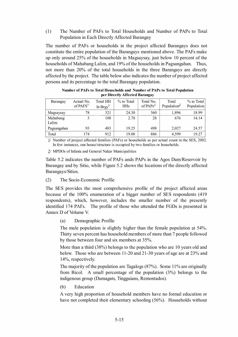
In case of the adopted Full Supply Level (FSL) of 159m for the Agos Dam/Reservoir, the directly affected Barangays are Magsaysay in Infanta, and Pagsangahan and Mahabang Lalim in General Nakar, all in the province of Quezon. The number of project affected families (PAFs) is estimated at 174 which translates to 886 project affected persons (PAPs).
5-15
(1) The Number of PAFs to Total Households and Number of PAPs to Total Population in Each Directly Affected Barangay
The number of PAFs or households in the project affected Barangays does not constitute the entire population of the Barangays mentioned above. The PAFs make up only around 25% of the households in Magsaysay, just below 10 percent of the households of Mahabang Lalim, and 19% of the households in Pagsangahan. Thus, not more than 20% of the total households in the three Barangays are directly affected by the project. The table below also indicates the number of project affected persons and its percentage to the total Barangay population.
Number of PAFs to Total Households and Number of PAPs to Total Population per Directly Affected Barangay
Barangay Actual No. of PAFS1/
Total HH In Brgy2/
% to Total HHs
Total No. of PAPs1/
Total Population2/
% to Total Population
Magsaysay 78 321 24.30 360 1,896 18.99 Mahabang Lalim
3 108 2.78 28 676 14.14
Pagsangahan 93 483 19.25 498 2,027 24.57 Total 174 912 19.08 886 4,599 19.27 1/ Number of project affected families (PAFs) or households as per actual count in the SES, 2002.
In few instances, one house/structure is occupied by two families or households.
2/ MPDOs of Infanta and General Nakar Municipalities
Table 5.2 indicates the number of PAFs ands PAPs in the Agos Dam/Reservoir by Barangay and by Sitio, while Figure 5.2 shows the locations of the directly affected Barangays/Sitios.
(2) The Socio-Economic Profile
The SES provides the most comprehensive profile of the project affected areas because of the 100% enumeration of a bigger number of SES respondents (419 respondents), which, however, includes the smaller number of the presently identified 174 PAFs. The profile of those who attended the FGDs is presented in Annex D of Volume V.
(a) Demographic Profile The male population is slightly higher than the female population at 54%. Thirty seven percent has household members of more than 7 people followed by those between four and six members at 35%. More than a third (38%) belongs to the population who are 10 years old and below. Those who are between 11-20 and 21-30 years of age are at 23% and 14%, respectively. The majority of the population are Tagalogs (87%). Some 11% are originally from Bicol. A small percentage of the population (3%) belongs to the indigenous group (Dumagats, Tingguians, Remontados).
(b) Education A very high proportion of household members have no formal education or have not completed their elementary schooling (56%). Households without

5-16
formal education and who are elementary undergraduates are at 27% and 29% respectively, while some 11% are high school undergraduates. Only 24 household members (1%) are college undergraduates. Household members who graduated from elementary school are at 14%; while 4% are high school graduates. Only 4 household members graduated from college while 6 household members claimed that they have post graduate degrees.
(c) Sources of Income Fifty two percent of household members have sources of income. Households derive their income from forest sources (68%) and agriculture (19%). The majority (90%) claimed that they earn not more than PhP 5,000 per month. Place of employment is within Quezon province (91%). As discussed in the earlier Sections, fishing is a major activity in the areas. Household members who claimed that they have been fishing for more than ten years are at 57%. The households who are categorized into livestock (29%) and poultry (33%) activities are commonly raising pigs, carabaos and chicken in the areas.
(d) Health and Sanitation Most common types of illnesses in the areas are fever, cough, flu, diarrhea and colds. The majority or 77% of the respondents opt to self-medicate, while some 20% seek professional help from doctors and Barangay health workers. About 58% claimed that there are no Barangay Health Centers in their respective Barangays. The majority (91%) stated that there are Barangay health workers in the area. Health workers, according to 45% of the respondents, visit them at least once a month. Services provided by rural doctors are very low at 2%.
(e) Housing and Lot Characteristics Out of the 170 respondents interviewed, under half or 46% claimed ownership to their lots where their houses are built. 24% have tax declarations, while those who claimed that they have Original/Transfer Certificate of Titles as proof of ownership are also at 24%. About 54% responded that they have other house and lot outside their Barangay. The type of dwellings is single-detached. Based on the results of the census and preliminary measurement surveys, the average house floor area is about 23.3 m2. Wood planks for walls and pawid and galvanized iron for roofs are predominantly used as the materials in the area.
(f) Living Conditions The majority or 97% of the respondents use kerosene as their source of lighting. Wood and charcoal are very widely used for cooking (95%). Some 4% use LPG/gas stove.
5-17
Most or 81% of the respondents draw water from the springs, while 16% derive their water from the Level-2 water supply system (Barangay /communal water supply system).
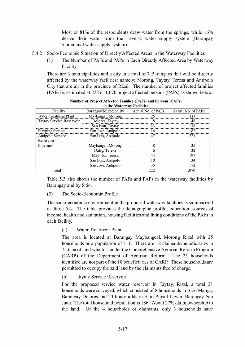
5.4.2 Socio-Economic Situation of Directly Affected Areas in the Waterway Facilities (1) The Number of PAFs and PAPs in Each Directly Affected Area by Waterway
Facility There are 3 municipalities and a city in a total of 7 Barangays that will be directly affected by the waterway facilities: namely; Morong, Taytay, Teresa and Antipolo City that are all in the province of Rizal. The number of project affected families (PAFs) is estimated at 222 or 1,070 project affected persons (PAPs) as shown below:
Number of Project Affected Families (PAFs) and Persons (PAPs) in the Waterway Facilities
Facility Barangay/Municipality Actual No. of PAFs Actual No. of PAPs Water Treatment Plant Maybangal, Morong 25 111
Dolores, Taytay 8 48 Taytay Service Reservoir San Juan, Taytay 23 138
Pumping Station San Jose, Antipolo 16 82 Antipolo Service Reservoir
San Luis, Antipolo 47 221
Maybangal, Morong 8 35 Dalig, Teresa 6 32
May-iba, Teresa 44 197 San Luis, Antipolo 10 34
Pipelines
San Jose, Antipolo 35 172 Total 222 1,070
Table 5.3 also shows the number of PAFs and PAPs in the waterway facilities by Barangay and by Sitio.
(2) The Socio-Economic Profile
The socio-economic environment in the proposed waterway facilities is summarized in Table 5.4. The table provides the demographic profile, education, sources of income, health and sanitation, housing facilities and living conditions of the PAFs in each facility.
(a) Water Treatment Plant The area is located at Barangay Maybangcal, Morong Rizal with 25 households or a population of 111. There are 18 claimants/beneficiaries in 75.6 ha of land which is under the Comprehensive Agrarian Reform Program (CARP) of the Department of Agrarian Reform. The 25 households identified are not part of the 18 beneficiaries of CARP. These households are permitted to occupy the said land by the claimants free of charge.
(b) Taytay Service Reservoir For the proposed service water reservoir in Taytay, Rizal, a total 31 households were surveyed, which consisted of 8 households in Sitio Manga, Barangay Dolores and 23 households in Sitio Pugad Lawin, Barangay San Juan. The total household population is 186. About 27% claim ownership to the land. Of the 4 households or claimants, only 3 households have
5-18
certificates of land ownership as proof. The majority (87%) stated that they have no other land as compared with the 13% who claimed that they have land in Rizal province.
(c) Pumping Station The area in Barangay San Jose, Antipolo City, is owned by 2 private individuals. A total of 16 households were identified with a total population of 82. In terms of land ownership, about 3% claim ownership to the land. However, these claimants cannot provide any proof of ownership. Only three households stated that they have other land located within Rizal province.
(d) Antipolo Service Reservoir The proposed area of 7 ha for the service reservoir is located at Barangay Luis, Antipolo City. The land is owned by a private individual and the LGU-Antipolo City. There are 47 households, considered as informal settlers. The total population is 221.
(e) Pipelines The proposed pipeline routes will traverse five (5) Barangays in the municipalities of Teresa and Morong and the City of Antipolo. A total of 103 households with a total population of 470 were identified in the area (refer to Table 5.2 for the number of households and population by Sitio/Barangay).
Annex D of Volume V also provides the socio-economic situation and perceptions towards the proposed Project of the indirectly affected areas, particularly the Barangays downstream of the proposed Agos Dam/Reservoir as well as Barangay Daraitan in Tanay located upstream of the proposed dam.
5.4.3 PAF’s Perceptions and Concerns about Resettlement in the Agos Dam and Reservoir Areas
The persons to be affected by the Agos Dam/Reservoir area were given opportunities to air their concerns and sentiments during the conduct of the SES and FGD. These perceptions were powerful insights and were taken into consideration in the preparation of the resettlement and compensation plan for this Study (refer to Annex D of Volume V for the detailed results of the SES and FGDs).
(1) Perception and Concerns of Project Affected Families (PAF) to Relocation
As previously mentioned, two methods were utilized to draw out the perceptions, general reactions and sentiments of the project affected people on the proposed project – the series of the FGDs and SES. These methodologies were reinforcing and complementary. But one cannot discount the views presented during the three public consultations held in Infanta (for Barangay Magsaysay), General Nakar (for Barangays Mahabang Lalim and Pangsangahan) and in Barangay Daraitan, Tanay. Being a forum where questions were answered, and suggestions received, the public consultations also provided invaluable views by key leaders/representatives on the project and on relocation. All these served as the most appropriate ways to describe
5-19
and encapsulate the affected people’s candid and unsuppressed thoughts on questions/issues posed to them.
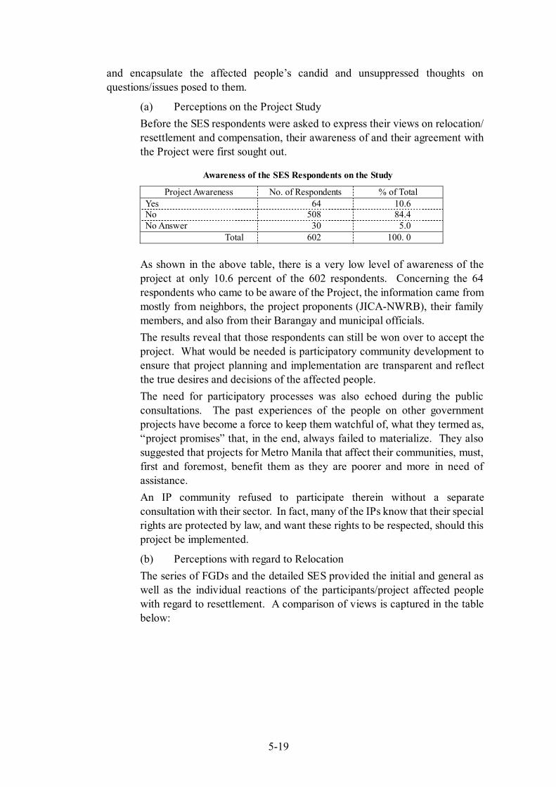
(a) Perceptions on the Project Study Before the SES respondents were asked to express their views on relocation/ resettlement and compensation, their awareness of and their agreement with the Project were first sought out.
Awareness of the SES Respondents on the Study
Project Awareness No. of Respondents % of Total Yes 64 10.6 No 508 84.4 No Answer 30 5.0
Total 602 100. 0
As shown in the above table, there is a very low level of awareness of the project at only 10.6 percent of the 602 respondents. Concerning the 64 respondents who came to be aware of the Project, the information came from mostly from neighbors, the project proponents (JICA-NWRB), their family members, and also from their Barangay and municipal officials. The results reveal that those respondents can still be won over to accept the project. What would be needed is participatory community development to ensure that project planning and implementation are transparent and reflect the true desires and decisions of the affected people. The need for participatory processes was also echoed during the public consultations. The past experiences of the people on other government projects have become a force to keep them watchful of, what they termed as, “project promises” that, in the end, always failed to materialize. They also suggested that projects for Metro Manila that affect their communities, must, first and foremost, benefit them as they are poorer and more in need of assistance. An IP community refused to participate therein without a separate consultation with their sector. In fact, many of the IPs know that their special rights are protected by law, and want these rights to be respected, should this project be implemented.
(b) Perceptions with regard to Relocation The series of FGDs and the detailed SES provided the initial and general as well as the individual reactions of the participants/project affected people with regard to resettlement. A comparison of views is captured in the table below:
5-20
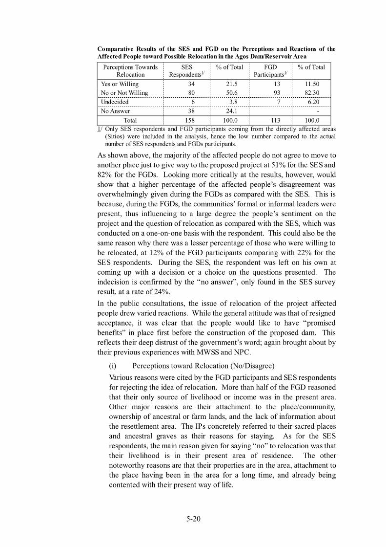
Comparative Results of the SES and FGD on the Perceptions and Reactions of the Affected People toward Possible Relocation in the Agos Dam/Reservoir Area
Perceptions Towards Relocation
SES Respondents1/
% of Total FGD Participants1/
% of Total
Yes or Willing 34 21.5 13 11.50 No or Not Willing 80 50.6 93 82.30 Undecided 6 3.8 7 6.20 No Answer 38 24.1 -
Total 158 100.0 113 100.0 1/ Only SES respondents and FGD participants coming from the directly affected areas
(Sitios) were included in the analysis, hence the low number compared to the actual number of SES respondents and FGDs participants.
As shown above, the majority of the affected people do not agree to move to another place just to give way to the proposed project at 51% for the SES and 82% for the FGDs. Looking more critically at the results, however, would show that a higher percentage of the affected people’s disagreement was overwhelmingly given during the FGDs as compared with the SES. This is because, during the FGDs, the communities’ formal or informal leaders were present, thus influencing to a large degree the people’s sentiment on the project and the question of relocation as compared with the SES, which was conducted on a one-on-one basis with the respondent. This could also be the same reason why there was a lesser percentage of those who were willing to be relocated, at 12% of the FGD participants comparing with 22% for the SES respondents. During the SES, the respondent was left on his own at coming up with a decision or a choice on the questions presented. The indecision is confirmed by the “no answer”, only found in the SES survey result, at a rate of 24%. In the public consultations, the issue of relocation of the project affected people drew varied reactions. While the general attitude was that of resigned acceptance, it was clear that the people would like to have “promised benefits” in place first before the construction of the proposed dam. This reflects their deep distrust of the government’s word; again brought about by their previous experiences with MWSS and NPC.
(i) Perceptions toward Relocation (No/Disagree) Various reasons were cited by the FGD participants and SES respondents for rejecting the idea of relocation. More than half of the FGD reasoned that their only source of livelihood or income was in the present area. Other major reasons are their attachment to the place/community, ownership of ancestral or farm lands, and the lack of information about the resettlement area. The IPs concretely referred to their sacred places and ancestral graves as their reasons for staying. As for the SES respondents, the main reason given for saying “no” to relocation was that their livelihood is in their present area of residence. The other noteworthy reasons are that their properties are in the area, attachment to the place having been in the area for a long time, and already being contented with their present way of life.
5-21
The answers of both the FGD and SES participants/respondents show clear similarities on why relocation is being rebuffed. The affected people’s sources of livelihood are within their immediate locale, thus relocation becomes a real threat to their existence, and a risk they refuse to take.
(ii) Perceptions toward Relocation (Yes/Agree/Willing to Negotiate/ Passive)
The majority of the SES respondents who were agreeable to be relocated cited that their willingness is hinged on proper compensation of the affected properties. The other reasons were spread among these: to support the implementation of the project, for the development of the area, the provision of livelihood projects and other sources of income. While a very small number of FGD participants accepted the option to be resettled, they did so because of the benefits they would receive. The foremost condition is having a well-planned resettlement area that goes with it and the chance of having a better quality life. Others mentioned the condition that their request for compensation, albeit quite high, must be granted, and that there must be a firm assurance for employment for themselves and their children. Only a few believed that the Project would be for the common good and expressed trust over the government’s decision. Again, there are striking similarities to the answers and/or conditions behind the “yes” to relocation. Foremost is just compensation, then the provision of livelihood and employment opportunities, and that the resettlement site should be well planned.
(c) Concerns with regard to Requirements and Assistance during Relocation
The FGD participants showed serious concern over the kind of assistance they would receive if forced to relocate. They mentioned over and over that employment and livelihood should be available, and that they be provided with a house and lot, farmland as well as educational facilities and scholarships for their children. They specifically proposed that they be given financial assistance in the form of capital for business. The public consultation became the venue for the people’s views on livelihood assistance. According to the participants, livelihood projects must be planned by the beneficiaries themselves, and must provide for sustainable mechanisms such as but not limited to availability of resources needed in the livelihood project, provision of skills training and financing.
(d) Views on Compensation and Compensation Procedure The great majority of the FGD participants wanted that all properties be compensated. They said that the basis of compensation must be the size of the land, type of dwelling units, crops and trees planted in their farm lands, and their land tenure. Some of the participants were undecided as to what
5-22
compensation is due for ancestral land. A few suggested compensation in kind that is land in exchange for land. The SES respondents wanted “proper compensation” of affected house and land. Many mentioned the necessity of having “proper consultation” through the active participation of the affected persons. During the public consultation, the participants wanted compensation procedures to be participatory; meaning the setting of payment fees and the system of payment must be established together with the affected people.
(e) Proposals on the Relocation Site Even with the FGD participants’ reservation on the project, they were asked to propose possible relocation sites. While around one-third of the participants could not identify acceptable relocation sites, another one-third refused to suggest any location because of their unwillingness to transfer. The rest said that the site must be within Quezon province that is safe and peaceful with employment opportunities and with ample agricultural land. The SES respondents, on the other hand, were stymied and could not identify a suitable relocation site, evident with the 90 percent “no answer” to this question. The rest indicated any place within Quezon province. In the public consultation, the people wanted relocations sites not far from where they are now located, or within the same Barangays. This sounds logical, as the affected people will be within the same familiar environment, and would be around people known to them; thus, the psychological effects coming from displacement would be minimized.
(f) Views on PAFs’ Involvement in the Project The FGD participants were vocal about their willingness to be actively involved in project implementation through labor employment. They viewed the project as an alternative source of income where they expect to be prioritized in terms of employment. They were also willing to undergo seminars and training to acquire the necessary skills. About one-third was interested in being part of the monitoring team; thus showing their concern for the impacts the Project may bring. The participants to the public consultation looked at involvement in two ways. First is involvement in project planning, implementation, and even monitoring. Second is involvement by being “workers” during the construction of the project. They want that the affected people, as well as the local people, be provided with opportunities to learn skills needed during project construction, and that they be given priority in employment.
(g) Perceptions of POs/NGOs on the Project Another set of opinions on the possible project and the relocation issue of the primary affected households came from the key informant interview of the existing People’s Organization and a NGO working in most of the areas under study. Essentially, similar attitudes to those in the FGDs were recorded
5-23
during the interviews, except only for SAMAKA (farmers organization) representative who was optimistic about the contribution of the dam project to the national development. Other specific issues raised were the following: Prioritizing local demand for water; conflict with existing development initiative, particularly the Community-Based Forestry Management (CBFM) by the SAMAKABAY, an upland farmers organization; Conflict with the Indigenous Peoples’ Rights Act (IPRA 8371) and the SMBDSM, a farmers organization IP communities; real concern for the welfare of the poor people who will be affected; and the possibility of looking for other sites for the Project Likewise, only the SAMAKA expressed willingness to be relocated provided the site is suitable and beneficial to the poor. There was also no specific site recommended for resettlement but some stated preference to places within General Nakar and Infanta or within the Quezon province. It is noted that the proposal for a relocation site cannot be equated with the willingness to transfer as previously explained in the case of the FGDs. Furthermore, proposed assistance for an acceptable relocation site also includes sustainable source of income/employment opportunities, own house and lot, presence of basic infrastructure and services and monetary form of compensation. Consistently, the IP group (SMBDSM) refused to give any suggestion but requested for a dialogue with JICA and NWRB on this sensitive issue.
(2) Perceptions and Concerns of the IP Communities on the Project
There are indigenous communities settled in Mahabang Lalim and Pagsangahan, which were included in the FGDs. In view of the nature of their existence and their legal claim on the area, it is a special sector, which has to be carefully considered in the Study. Overall, 34 participants or eight percent of the total number of FGD participants were representatives of the indigenous community, including those who attended the FGDs in Km 11 and Kidadayaig in Magsaysay and Makalya in Pagsangahan. These 3 sitios, however, are outside the directly affected areas.
(a) IP’s Acceptance of the Project The data revealed that none of the four IP groups expressed acceptance of the project although two of them were willing to negotiate. In general, they also believed that it will be the government’s decision that must prevail in the end but they were also decided to make a petition or to organize demonstrations to stop the project whenever necessary. It must also be noted that further consultation especially regarding the case of affected IPs was strongly proposed.
5-24
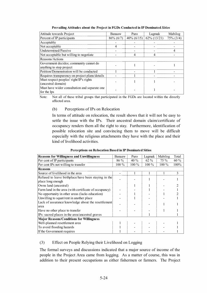
Prevailing Attitudes about the Project in FGDs Conducted in IP Dominated Sitios
Attitude towards Project Banaaw Puro Lagmak Mabilog Percent of IP participants 86% (6/7) 40% (6/15) 62% (13/21) 75% (3/4) Acceptable - - - - Not acceptable 4 - - - Undetermined/Passive - - - 4 Not acceptable but willing to negotiate - 4 4 - Reasons/Actions Government decides; community cannot do anything to stop project - 1 - 1
Petition/Demonstration will be conducted 1 - 1 - Requires transparency on project plans/details - 1 - - Must respect peoples' right/IP's rights (ancestral domain) - 1 1 -
Must have wider consultation and separate one for the Ips - - 1 -
Note: Not all of these tribal groups that participated in the FGDs are located within the directly affected area.
(b) Perceptions of IPs on Relocation In terms of attitude on relocation, the result shows that it will not be easy to settle the issue with the IPs. Their ancestral domain claim/certificate of occupancy renders them all the right to stay. Furthermore, identification of possible relocation site and convincing them to move will be difficult especially with the religious attachments they have with the place and their kind of livelihood activities.
Perceptions on Relocation Based in IP Dominated Sitios
Reasons for Willingness and Unwillingness Banaaw Puro Lagmak Mabilog Total Per cent of IP participants 86 % 40 % 62 % 75 % 60 % Per cent IPs not willing to transfer 100 % 100 % 100 % 100 % 100% Reasons Source of livelihood in the area - 1 1 1 3 Refused to leave birthplace/have been staying in the place long enough - - 1 - 1
Owns land (ancestral) 1 1 - 2 Farm land in the area (with certificate of occupancy) - - 1 - 1 No opportunity in other areas (lacks education) - 1 - 1 2 Unwilling to squat/rent in another place - 1 - - 1 Lack of assurance/knowledge about the resettlement area - - - 1 1
Have no other place to transfer - - - 1 1 IPs: sacred places in the area/ancestral graves 1 1 Major Reasons/Conditions for Willingness Well-planned resettlement area 1 - - - 1 To avoid flooding hazards 1 - - - 1 If the Government requires 1 - - - 1
(3) Effect on People Relying their Livelihood on Logging
The formal surveys and discussions indicated that a major source of income of the people in the Project Area came from logging. As a matter of course, this was in addition to their present occupations as either fishermen or farmers. The Project

5-25
must, therefore, provide alternative sources of livelihood to replace income derived from logging.
In the public consultation, the participants expressed that planning, selection and implementation of livelihood project must be demand-driven and participatory. They are opposed to past government initiatives where livelihood projects were provided on a top-down manner, which did not consider the true needs of the affected people. The provision of livelihood projects must also be sustained, to ensure that even without the proponents, the people can carry on these livelihood projects that were started.
5.4.4 PAF’s Perception about Resettlement in Areas of Proposed Waterway Facilities
(1) Water Treatment Plant
More than half or 52% expressed a positive attitude towards relocation; some eight percent have negative sentiment about being relocated, while 40% did not answer. Thirty-one percent stated their support on the implementation of the development project.
In terms of place for relocation, 53% of those who agreed to be relocated stated their preference within the same municipality. Forty two percent did not provide any information. Their bases to be relocated are: provision of livelihood projects, 61%; proper compensation for affected assets, 23%; and proper consultation and participation, 15 %.
(2) Taytay Service Reservoir
More than half (53%) expressed a positive response towards relocation due to the following reasons: need a stable job in a relocation site (75%), support the project (12%) and do not own the place (12%). Those who agreed to be relocated chose the province of Rizal.
(3) Pumping Station
Sixty nine percent expressed a positive response towards relocation. The majority or 82% stated the need for proper compensation for lost assets. Some 18% expressed their support towards the Project and are willing to be relocated. Eighty two percent opted to be relocated, within Rizal province, while two households or 18% chose to move to Camarines Sur and Surigao City.
(4) Antipolo Service Reservoir
The majority or 90% expressed positive opinion towards relocation. Forty percent stated the need for proper compensation of affected land and assets, while a quarter responded that they have no other place to live and would like to have a more convenient environment. Thirteen percent replied the need for livelihood projects. Some 11% expressed their support towards the proposed Project.
(5) Pipelines
High proportions of households who expressed a positive response towards relocation are in Sitios Pantay, Tagbak and Burol at 68%, 62% and 52%, respectively.

5-26
Those who have high percentage of households who are undecided are found in Sitio Aranda at 70% and Sitio Talaga at 62%. In Sitio Uno, there is a slight variation between households who agreed to be relocated and those who are undecided at 41% and 47%, respectively. Less than half (46%) of households who expressed a positive response towards relocation is found in Sitio Pag-asa.
The most common reasons of those who agreed to be relocated are: support towards the project implementation, proper compensation for affected assets, provision of livelihood/job opportunities and provision of a relocation site.
The table below shows a summary of the perceptions toward relocation of the directly affected people for each of the proposed waterway facilities.
SES Results on the Perception of the Affected People Toward Possible Relocation in the Proposed Waterway Facilities (in % to Total Respondents)
Perception Toward Relocation
Water Treatment Plant
Taytay Service Reservoir
Pumping Station
Antipolo Service Reservoir
Pipelines/1
Yes or Willing 52.00 53.30 68.80 89.4 47.90 No or Not Willing 8.00 6.70 18.80 - 8.80 Undecided - 40.00 12.40 4.2 43.30 No answer 40.00 - - 6.4 -
Total 100.00 100.00 100.0 100.00 100.00 Note: /1; Average for the 7 Sitios that are directly affected.
5.4.5 Community Participation Through Public Consultation
As previously stated, the planning for this Project involved public participation in many forms. The most direct participation was by the conduct of stakeholders consultations or focus group discussions (FGDs) at Sitio level, public consultations at Barangay level and workshops whereby local and national government officials, as well as NGOs/POs and the private sector were invited to provide concerns and recommendations for appropriate mitigation measures. Descriptions of the result of the consultations at the Sitio and Barangay levels were earlier presented in the foregoing Subsection 5.4.3, particularly on the issue of resettlement (refer to Annex D of Volume V for the summary of discussions of the public consultations by Barangay).
The participants of the 2 workshops provided suggestions to their identified issues and questions (refer to Annex D of Volume V for the summary of major issues/questions raised and the corresponding recommendation/countermeasures).
In both workshops, a common consent was given by the participants in regard to the two basic matters presented in the workshop as follows:
• No particular opposition to the necessity of the proposed Project, where the necessity is expressed as:
a) Necessity of water supply to Metro Manila, Rizal and partial areas of Cavite, in order to sustain the required level of hygienic conditions in the concerned areas. (With the condition that the issues and concerns raised during the workshop and succeeding consultations thereof be given due consideration.)

5-27
b) Effective use of hydropower development potential created by the Agos Dam (Power Plant) for the benefit to national economy as well as for securing stable power supply sources in the vicinity.
• Principles of the implementation of the Relocation Plan to cover:
a) Community participatory approaches b) Provision of well-planned resettlement sites c) Resettlement procedures in line with the pre-established rules; and d) Need of income restoration and livelihood supporting the programs
for the PAFs. The income restoration and livelihood program will be developed during the succeeding phase of the Project development.
5.4.6 The Requirement for Resettlement of PAFs in the Directly Affected Areas
Not all the Sitios in the three directly affected Barangays will be inundated as a result of the project. There are nine Sitios that would be directly affected in Barangay Pagsangahan, one in Mahabang Lalim, and nine in Magsaysay (refer to Table 5.2 for the details). It is noted that the SES did a 100% enumeration of the potentially affected people through foot surveys initially identifying more affected families due to the difficulty in ascertaining the actual topography of the project affected areas. The number of PAFs in the directly affected areas by the Agos Dam/Reservoir is estimated at 174.
For the PAFs identified in the waterway facilities, financial assistance will be provided in order for them to purchase residential lots on top of the disturbance compensation that will also be provided. No resettlement site will be made available for them. A summary table of the total number of PAFs and PAPs in the directly affected project area is shown below:
Total Number of PAFs and PAPs in the Directly Affected Project Area
Facility Actual No. of PAFs Actual No. of PAPs Agos Dam/Reservoir 174 886
Water Treatment Plant 25 111 Taytay Service Reservoir 31 186 Pumping Station 16 82 Antipolo Service Reservoir 47 221
Waterway
Pipelines 103 470 Total 396 1,956
5.4.7 Potential Resettlement Area
The potential resettlement areas were pinpointed as a result of the perceptions and subsequent suggestions of the project affected people. Thus, the Project endeavors that the project affected people will be relocated within the same Barangays to reduce the psychological traumas associated with involuntary displacement. The two proposed resettlement areas are shown in Figure 5.2. The total cost estimates for Resettlement Site No. 1 and No. 2, including land acquisition and site development, are PhP 279,438,000 and PhP 299,232,000, respectively.

5-28
The Resettlement Site Development Plan, which contains the proposed areas for resettlement and includes the requirement for land areas, housing and other community structures and amenities is presented in Annex D of Volume V.
5.5 The Resettlement Plan (RP)
5.5.1 Resettlement Plan
The number of persons directly affected by the Agos Reservoir is considered significant requiring a full resettlement plan (RP). The resettlement effects are the loss of productive and other assets such as land where many people do not have legal title to their assets. There is also the loss of incomes and livelihoods; the loss of housing, community structures, systems and services; and the loss of household or community resources, habitat and sites. The Project would also affect a number of indigenous people, many of whom are nomadic and who have their means of subsistence within the project area.
The requirement for the RP is to compensate those directly affected with replacement cost and institute sustainable income restoration measures. There may be an urgent need to provide relocation, transfer assistance, and provide for measures to restore the living standards of those affected. Special measures are required for the IPs.
The prepared RP includes the socio-economic conditions of the Study Area; the census, inventory of losses and preliminary measurement surveys; the legal framework, the principles and objectives of the project; the conditions for eligibility and entitlement, the approaches to ensure consultation and people’s participation; and mechanisms for grievance redressal. The RP also provides for resettlement strategies, the organizational framework for implementation, a general implementation schedule and the system of supervision, monitoring and evaluation. Finally, initial cost estimates are provided on the affected land and land improvements, loss of houses, public and community structures, relocation and rehabilitation assistance, and other costs. The details of the RP are presented in Annex D of Volume V.
(1) Consultation and Participation
Information dissemination to, consultation with, and participation of PAPs and various stakeholders maintain transparency of the Project, reduce potential conflicts, minimize the risk of Project delay, and enable the Project to design the resettlement and the rehabilitation programs as a comprehensive development program to suit the needs and priorities of the PAPs.
Extensive consultation and participation programs will continue throughout the duration of the Project. This RP will be updated taking into consideration the careful assessment and planning specifically on relocation income and livelihood issues as it may pose some conflicts to existing development efforts or social interventions in the area by both the government and non-government organizations.
Community participation is vital to the successful implementation of the project. The people must be involved and one way is providing employment to many
5-29
unproductive household heads whose main livelihood is illegal logging, and whose skills can be upgraded. Social development can be realized through participatory community development measures, and this participation has been manifested and expressed in various fora through empowering the communities to make decisions on many matters that affect them, such as the choice of relocation, compensation procedures and livelihood.
Participation can be raised by effective strategic communication, where a separate Strategic Communication Plan has been prepared and presented in Annex D.
The technical feasibility of the project is a major assumption in the following recommendations.
• Sincerity in looking at the welfare especially of the primary impact communities must be evident both in terms of the approaches and content in dealing with them. The people in the area have a lot of similar experiences and have become cautious about their level and nature of participation.
• Encourage sense of ownership early in the project cycle. Carefully consider the demands and issues raised by the communities either by acting on those demands or otherwise laying down the appropriate explanations. Be willing to extend project planning until community support is established. Carefully study other unique contributions that may be derived from the community aside from mere source of data and information.
• Carefully study and consult with the concerned government and non-government agencies regarding the existing development initiatives in the area particularly those pertaining to forest management and the indigenous peoples’ rights.
• Invest on community development efforts especially as an alternative to stop dependence of the community relying on illegal logging activities, which will also affect the project operation. Support community-organizing activities and coordinate with the NGOs and POs in the area. Sustainability of any community development intervention must be ensured to promote self-reliance among community people.
• Continue to hold public consultations prior to the implementation of the Project, where JICA and NWRB can discuss the project details and related issues with the representatives of the communities and the IP sector. A separate dialogue with the IP sector will also be conducted as necessary.
(2) Grievance Redressal Mechanism
The main objectives of the grievance redressal procedure are to provide a mechanism to ensure that the compensation and resettlement programs have been implemented accurately and fairly, to mediate conflict and to avoid lengthy litigation that can delay the Project.
The PAPs will be made fully aware of their rights to grievance and the procedures by doing so verbally and in writing during consultation, census and survey and time of

5-30
compensation. The PAPs may present their complaints to the concerned LGUs. The complaint can be filed first at the Barangay level and can be elevated to the provincial or judicial level if the PAPs are not satisfied with the decisions made at the Barangay/municipal level. The PAPs will be exempted from all taxes and administrative fees.
The concerned LGUs at each level will settle the issue within 15 days. The Social and Resettlement Division (SRD) of the IA will also act as grievance officers and will assist the PAPs and attempt to settle the issues at the Barangay level through community consultation. The Project will also request the involvement of NGOs as required and concerned local-based organizations.
Experiences show that not all PAPs have writing skills and the ability to express grievances verbally. Therefore, the PAPs are encouraged to seek assistance from the family members, NGOs or community organizations in order to have their grievances recorded in writing and to ensure that all disputes are properly recorded and resolved in a participatory manner.
(3) Implementation Arrangements
The Executing Agency will establish a Project Management Office for the overall planning, implementation and coordination of the Project including resettlement and land acquisition activities. The PMO will be headed by a Project Director. The prospective schedule of resettlement and land acquisition activities is shown in Table 5.5.
(4) Supervision, Monitoring and Evaluation
The objectives of the monitoring program are to (i) ensure that the standard of living of PAPs are restored or improved; (ii) monitor whether the overall project and resettlement objectives are being met; (iii) assess if rehabilitation measures and compensation are sufficient; (iv) identify problems or potential problems; and (v) identify methods of responding immediately to mitigate problems.
A monitoring and evaluation program will be implemented to record and assess project inputs and the number of persons affected and compensated, and confirm that former subsistence levels and living standards are being re-established.
The range of activities and issues that would therefore have to be recorded and checked, include: Land acquisition and transfer procedures; Compensation payments; Construction of replacement houses by PAPs; Re-establishment of PAPs and business enterprises; Reaction of PAPs, in particular, to resettlement and compensation packages; and Re-establishment of income levels.
5.5.2 Preliminary Estimate of Environmental Cost
The RP budget can only be considered as estimates and will have to be continually revised and/or updated to achieve the resettlement objectives. The cost estimate is presented in more detail in Annex D of Volume V. All estimates are in Philippine Peso (PhP).

5-31
(1) Affected Land The scale of land acquisition at the Agos Dam/Reservoir area and waterway facilities can only be determined during detailed design. All land will be verified and finalized during the official census and tagging when the detailed measurement surveys will be carried out. The cost is estimated at about PhP 633,540,000 for the affected land (See Annex D for detail).
(2) Affected Houses / Loss of Structures Replacement costs for affected houses and structures are equivalent to the current market value of materials and labor costs in the area without deduction for depreciation and/or salvageable materials. For this estimate, the cost for houses and structures within the directly affected areas will be included. If the PAP opts to relocate at the developed resettlement site, house differential will be applied. The cost for affected houses and structures is estimated at PhP 12,818,000 (See Annex D for detail).
(3) Public or Communal Structures Replacement Costs for public or communal structures are equivalent to the current market value of materials and labor costs in the area without deduction for depreciation and/or salvageable materials. The cost for public or communal structures is estimated at about PhP 1,404,000 (See Annex D for detail).
(4) Affected Crops and Trees The number and types of affected crops and trees will only be determined during the detailed design stage. Market rates will be applied to reflect replacement costs for such losses.
(5) Relocation and Rehabilitation Assistance
Regional development projects and rehabilitation assistance including income restoration programs can only be prepared during the detailed design stage. Extensive consultation and participation programs will be designed and implemented based on the needs and priorities of the affected communities.
As for disturbance compensation and financial assistance, the cost is calculated at about PhP 5,945,200.
a. Disturbance Compensation
All relocating PAFs will be entitled to the disturbance compensation equivalent to the minimum wage per day in the area (PhP 145/day) multiplied by 60 days. The cost for disturbance compensation is estimated at PhP 3,446,000 (See Annex D of Volume V for detail).
b. Financial Assistance
The PAFs identified at the water treatment plant, Antipolo service reservoir, pumping station, Taytay service reservoir and the conveyance routes are house owners who occupy private/public lands free of charge. To ensure that PAFs will not be left landless because of the Project, financial assistance will be provided in order

5-32
for PAFs to purchase residential lots. The size of residential lot will be 200 m2. in rural areas, 120 m2 in semi-urban areas and 90 m2 in highly urbanized areas. The cost for financial assistance is estimated at about PhP 32,500,000 (See Annex D for detail).
(6) Overall Environmental Cost for the Project
The overall total cost estimate for the Project includes the cost of losses such as affected land, houses and structures, community/public structures, and the cost of compensation and assistance. It also takes account of the cost of the resettlement site development and that of strategic communications.
Administrative/operational costs, external monitoring activities and contingency costs will be included in the overall project cost upon the updating of this RP.
The total environmental cost for the Project is estimated to be PhP 1,269,264,000 as shown below:
Summary of Environmental Cost for the Project
Items Total Cost Estimates (PhP) Cost of Losses/Compensation/Assistance Affected Land 633,540,000 Houses and Structures 12,818,000 Communal/Public Structures 1,404,000 Disturbance Compensation 3,446,000 Financial Assistance 32,500,000 Cost of Resettlement Site Development 578,670,000 Cost of Strategic Communications 6,886,000
RP Cost Estimates 1,269,264,000
The costs estimated above represent those directly related to the resettlement. The total cost of land acquisition and resettlement is separately estimated incorporating other land acquisition costs (e.g. reservoir area, construction areas, etc.) and contingencies for miscellaneous items which are unpredictable at this study stage.
5.6 Environmental Management and Monitoring Plan
This Environmental Management and Monitoring Plan (EMMP) presents the environmental policy and objectives of the environmental management system, the development guidelines covering water, soil, biological environment and socio-economic parameters and development guidelines along with various elements of the Social Development Plan, and the institutional aspect. The EMMP also provides a program and an action plan for the scoping of the environmental management system. This includes a matrix consisting of mitigative measures for each specific negative impact, responsibilities and authorities, monitoring including time frame, and cost estimates related to mitigating measures.
It is expected that this EMMP be revised and updated once the final detailed design has been completed and evaluated. Relevant sections should form part of the tender documents for construction of the various facilities.
5-33
5.6.1 Environmental Management System (EMS)
Consistent with the Government’s effort in promoting environmental protection as embodied in its Constitution, the Study strives to achieve a “low environmental impact” project within the context of sustainable development. It aims to operate the project as an environmentally sound facility. The environmental policy is therefore directed towards:
• Procedures to implement sound environmental management and monitoring practices that allow for continued improvement within the EMS.
• Services that maximize the use of environment friendly facilities or the use of environmentally sound technologies that conserve the natural resources.
• Methods to incorporate design and practice for environmental consciousness in the delivery of services.
5.6.2 Environmental Management and Monitoring Plan (EMMP)
This EMMP is formulated to ensure that construction and operation activities adhere to the environmental objectives of the Project. It will embody the commitments of the project proponent and delineate sphere of responsibilities of key actors.
The environmental objectives of the Project include the following:
• To promote protection of the environment and socio-economic upliftment through sustainable economic activities;
• To comply with all applicable environmental standards set by the government;
• To ensure transparency and involvement of the contractors and operators on environmental issues;
• To guarantee the submission of all reports on the environmental performance of the project required by the different government agencies, and
• To maintain active involvement of stakeholders in water management and environmental awareness.
In line with these objectives, the EMMP is deemed an effective tool in managing environmental performance. The formulation of the EMMP will enable the identification of critical environmental issues, the development of action plans to address these issues, the establishment of environmental performance indicators, and raising environmental awareness among staff, contractors and the eventual users, as well as providing appropriate training and strategic communication plan or information, education and communication interventions.
Annex D of Volume V presents the development guidelines covering land, water, air and biological environment as well as the social development plan.
5.6.3 Environmental Monitoring Plan
As a precautionary measure against adverse/negative impacts of the development and operation of the Agos Dam and its associated infrastructures, the Project
5-34
Proponent would lead in the organization of a Multi-partite Environment Monitoring Team (MEMT). The Team shall be composed of representatives from the Project Proponent, the local government unit (LGU) concerned, the non-government organization (NGO), the Department of Agriculture (DA) and headed by a representative from the Department of Environment and Natural Resources (DENR).
Monitoring of the environmental conditions in the Project area shall commence upon the issuance of the Environmental Compliance Certificate (ECC) by the DENR. Monitoring shall be scheduled quarterly for the first year, and bi-annually thereafter, in order to detect any changes in the environment brought about by the Project.
Among others, the MEMT shall monitor the following environmental parameters, which involved terrestrial and aquatic flora and fauna, surface riverine waters, occurrence of floods, and the socio-economic condition of the inhabitants, particularly in the Agos River Basin resulting from the establishment of the Agos Dam/Reservoir:
a) Changes in the dam structure, breaching and/or scouring, sediment deposition, occurrence of water overflows particularly during heavy rainfalls;
b) Water quality, particularly turbidity/sedimentation, DO, BOD, pH, trace metals and bacteriological contamination;
c) Water movement in the rivers, streams, creeks and other waterways caused by the development of the reservoir; land submergence in some areas, and development of built-up areas;
d) Occurrence of flooding to detect water flow obstructions and/or breaks in the river embankments;
e) Regular inspection, maintenance, reinforcement of riverbanks to ensure that they remain adequate to provide protection against flooding and overflows;
f) Regular inspection of the coastal and downstream section of the Agos River to ensure that there is sufficient volume of water flowing to maintain aquatic fauna in the reservoir;
g) Revegetation growth along the riverbanks and in the watershed to restore the habitat, nesting sites and nooks of birds, insects and wildlife, to hasten their colonization of the area;
h) Establishment of sampling stations where terrestrial/aquatic and air data will be collected regularly for monitoring of the environmental conditions in the Project site by the Environmental Monitoring Team. Specifically, air quality data on possible gas emissions from the reservoir, such as carbon dioxide, nitrous oxide and sulfuric oxide will be monitored during and after construction of the Agos Dam.
The summary matrices of the Environmental Management Plan are presented in Table 5.6. The Environmental Management Plan is presented in Annex D of Volume V.
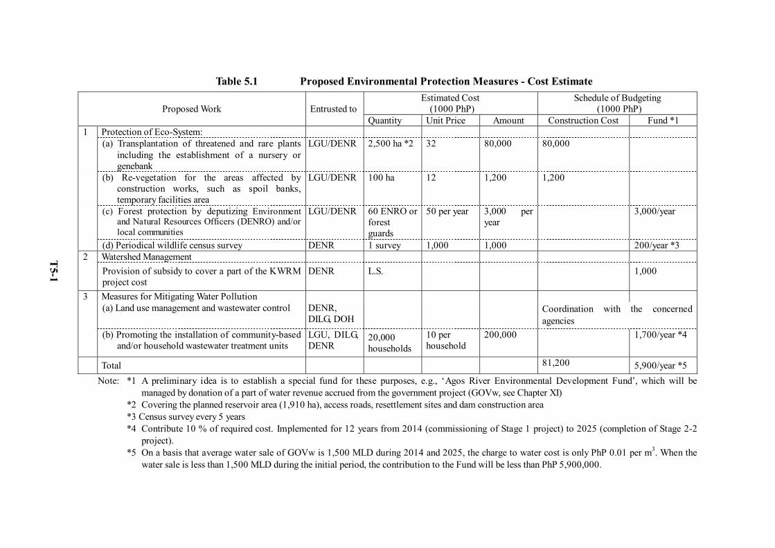
Table 5.1 Proposed Environmental Protection Measures - Cost Estimate Estimated Cost
(1000 PhP) Schedule of Budgeting
(1000 PhP)
Proposed Work
Entrusted to Quantity Unit Price Amount Construction Cost Fund *1
Protection of Eco-System: (a) Transplantation of threatened and rare plants
including the establishment of a nursery or genebank
LGU/DENR 2,500 ha *2 32 80,000 80,000
(b) Re-vegetation for the areas affected by construction works, such as spoil banks, temporary facilities area
LGU/DENR 100 ha 12 1,200 1,200
(c) Forest protection by deputizing Environment and Natural Resources Officers (DENRO) and/or local communities
LGU/DENR 60 ENRO or forest guards
50 per year 3,000 per year
3,000/year
1
(d) Periodical wildlife census survey DENR 1 survey 1,000 1,000 200/year *3 Watershed Management 2 Provision of subsidy to cover a part of the KWRM project cost
DENR L.S. 1,000
Measures for Mitigating Water Pollution (a) Land use management and wastewater control DENR,
DILG, DOH Coordination with the concerned
agencies
3
(b) Promoting the installation of community-based and/or household wastewater treatment units
LGU, DILG, DENR
20,000 households
10 per household
200,000 1,700/year *4
Total 81,200 5,900/year *5 Note: *1 A preliminary idea is to establish a special fund for these purposes, e.g., ‘Agos River Environmental Development Fund’, which will be
managed by donation of a part of water revenue accrued from the government project (GOVw, see Chapter XI) *2 Covering the planned reservoir area (1,910 ha), access roads, resettlement sites and dam construction area *3 Census survey every 5 years *4 Contribute 10 % of required cost. Implemented for 12 years from 2014 (commissioning of Stage 1 project) to 2025 (completion of Stage 2-2
project). *5 On a basis that average water sale of GOVw is 1,500 MLD during 2014 and 2025, the charge to water cost is only PhP 0.01 per m3. When the
water sale is less than 1,500 MLD during the initial period, the contribution to the Fund will be less than PhP 5,900,000.
T5-1
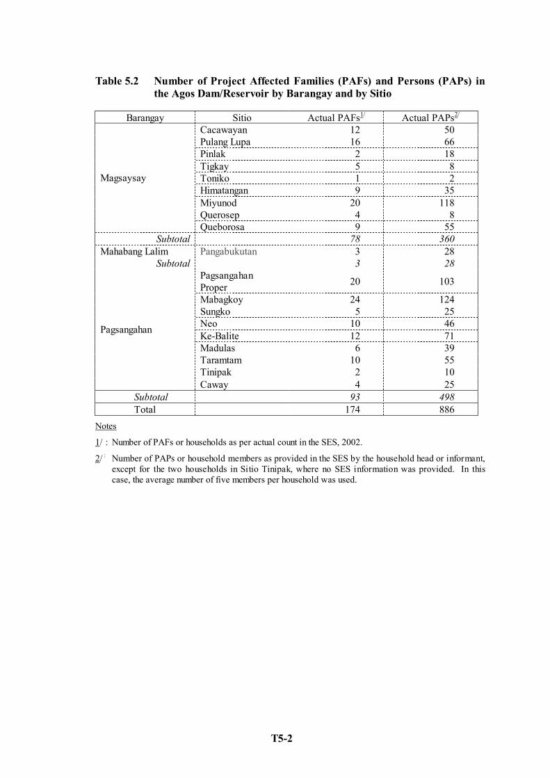
T5-2
Table 5.2 Number of Project Affected Families (PAFs) and Persons (PAPs) in the Agos Dam/Reservoir by Barangay and by Sitio
Barangay Sitio Actual PAFs1/ Actual PAPs2/
Cacawayan 12 50 Pulang Lupa 16 66 Pinlak 2 18 Tigkay 5 8 Toniko 1 2 Himatangan 9 35 Miyunod 20 118 Querosep 4 8
Magsaysay
Queborosa 9 55 Subtotal 78 360
Mahabang Lalim Pangabukutan 3 28 Subtotal 3 28
Pagsangahan Proper 20 103
Mabagkoy 24 124 Sungko 5 25 Neo 10 46 Ke-Balite 12 71 Madulas 6 39 Taramtam 10 55 Tinipak 2 10
Pagsangahan
Caway 4 25 Subtotal 93 498 Total 174 886
Notes
1/ : Number of PAFs or households as per actual count in the SES, 2002.
2/ : Number of PAPs or household members as provided in the SES by the household head or informant, except for the two households in Sitio Tinipak, where no SES information was provided. In this case, the average number of five members per household was used.
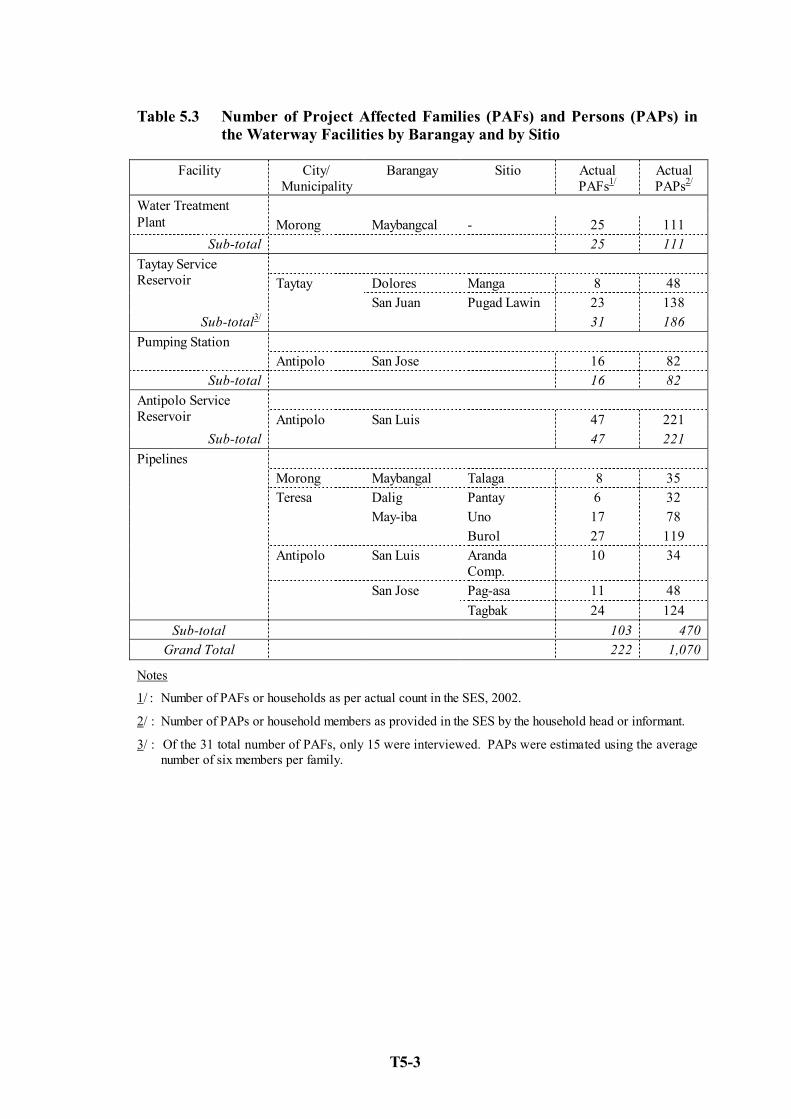
T5-3
Table 5.3 Number of Project Affected Families (PAFs) and Persons (PAPs) in the Waterway Facilities by Barangay and by Sitio
Facility City/ Municipality
Barangay Sitio Actual PAFs1/
Actual PAPs2/
Water Treatment Plant Morong Maybangcal - 25 111
Sub-total 25 111
Dolores Manga 8 48 Taytay Service Reservoir Taytay
San Juan Pugad Lawin 23 138 Sub-total3/ 31 186
Pumping Station Antipolo San Jose 16 82
Sub-total 16 82 Antipolo Service
Reservoir Antipolo San Luis 47 221 Sub-total 47 221
Morong Maybangal Talaga 8 35
Dalig Pantay 6 32 Uno 17 78
Teresa May-iba
Burol 27 119 Antipolo San Luis Aranda
Comp. 10 34
Pag-asa 11 48
Pipelines
San Jose Tagbak 24 124
Sub-total 103 470 Grand Total 222 1,070
Notes
1/ : Number of PAFs or households as per actual count in the SES, 2002.
2/ : Number of PAPs or household members as provided in the SES by the household head or informant.
3/ : Of the 31 total number of PAFs, only 15 were interviewed. PAPs were estimated using the average number of six members per family.

Table 5.4 Socio-economic Profile of Directly Affected Areas in the Waterway Facilities
Indicator Water Treatment Plant Taytay Service Reservoir Pumping Station Antipolo Service Reservoir Pipelines
Demographic Profile - Ave. Number of Household Members - Ratio of Male to Female Population
- Ethnic Composition -
- Age Composition
1 – 3 members; 44% 4 – 6 members; 36% Male; 52% Female; 48% Tagalog (Majority) 20 yrs old & below; > 50% 21-40 yrs old; 30%
> 7 members; 40% 1 – 3 members; 33% Male; 50% Female; 50% Tagalog (Majority) 20 yrs old & below; 57% 21-40 yrs old; 27%
4 – 6 members; 55% 1 – 3 members; 19% Male; 55% Female; 45% Tagalog; 41% Bicolanos; 35% 20 yrs old & below; 44% 21-40 yrs old; 35%
--- Male; 50% Female; 50% Visayans; 56% Tagalogs; 35% 10 yrs old & below; 40% 21-40 yrs old; 30%
> 7 members; 60% (San Luis, Sitio Pag-asa) --- Tagalogs (44 to 83%) 20 yrs old & below; 40-59%
Education Formal education not completed; 34% No formal education; 16%
Formal education not completed; 36% No formal education; 22%
Formal education not completed; 45% No formal education; 20%
Formal education not completed; 43% No formal education; 31%
Formal education not completed and No formal education; 9 – 43%
Sources of Income - Unemployment Rate - Employment Sector (in %) - Place of Employment (in %) - Monthly Income
77% - Industry/Construction; 60 - Agriculture; 20 - Service; 14 - Rizal; 87 - Metro Manila; 13 < PHP 5,000
64% - Industry/Construction; 41 - Agriculture; 18 - Service; 41 - Rizal; 82 - Metro Manila; 12 < PHP 5,000; 65%
--- - Service; 70 - Rizal; 47 - Metro Manila; 23 PHP 5,000-10,000; 53%
--- - Industry/Construction; 51 - Service; 30 - Rizal; Majority < PHP 5,000; 70%
54 – 69% - Industry/Construction; 50 to 58 - Service; 44 to 47 - Outside municipality or city < PHP 5,000; 44 to 78%
Health and Sanitation - Common Sicknesses - Means of Medical Treatment - Availability of Brgy. Health Center - Availability of Rural Doctor (monthly) - Availability of Other Health Workers (monthly)
Fever, cough, colds and flu Self medication; 76% 84% 40% 84%
Fever, cough and colds Self medication; >50% 33% 42% 42%
Fever, cough and colds Self medication; 75% 100% 44% 81%
Fever, cough and colds Self medication; 94% 94% 62% 94%
Fever, cough, colds, flu Self medication; 58 - 74% high high high
Housing and Lot Characteristics - Type of Housing - Ave. House Floor Area - Housing Materials - Ownership of Land
Single-detached 31.36 sqm Walls - “Sawali”, plywood,
CHB Roofs - Galvanized iron,
anahaw ---
Single-detached --- Walls – makeshift materials Roofs - Galvanized iron Owned; 27%
Single-detached --- Walls – makeshift materials,
CHB Roofs - Galvanized iron Owned; 30%
--- 23.60 sqm Walls – makeshift materials Roofs - --- Owned; ---
Single-detached 23.60 sqm Walls – makeshift materials
(Pantay,Aranda) Roofs – Galvanized iron Owned; 65-67%
Living Condition (in %) - Source of Lighting - Cooking Fuel - Water Supply Source
Kerosene; 80 Batteries; 20 Wood/Charcoal; 68 LPG/Gas Stove; 28 Own water pump; 44 Communal water supply; 24 Spring; 24
Kerosene; 87 Local power grid; 13 Wood/Charcoal; 87 LPG/Gas Stove; 13 Spring; 93
Local power grid; 81 Kerosene; 18 LPG/Gas Stove; 56 Wood/Charcoal; 19 Cooperative-owned; 81
Kerosene; 64 Local power grid; 28 Wood/Charcoal; 83 LPG/Gas Stove; 11 Spring; 52 Local water service provider; 34
Local grid; Majority LPG/Gas Stove; Majority Own water pump; Majority
Source of Data: Socio-economic Survey, 2002
T5-4
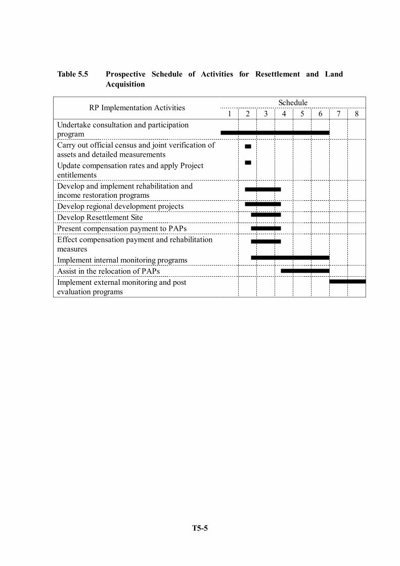
T5-5
Table 5.5 Prospective Schedule of Activities for Resettlement and Land Acquisition
Schedule RP Implementation Activities 1 2 3 4 5 6 7 8
Undertake consultation and participation program
Carry out official census and joint verification of assets and detailed measurements
Update compensation rates and apply Project entitlements
Develop and implement rehabilitation and income restoration programs
Develop regional development projects Develop Resettlement Site Present compensation payment to PAPs Effect compensation payment and rehabilitation measures
Implement internal monitoring programs Assist in the relocation of PAPs Implement external monitoring and post evaluation programs
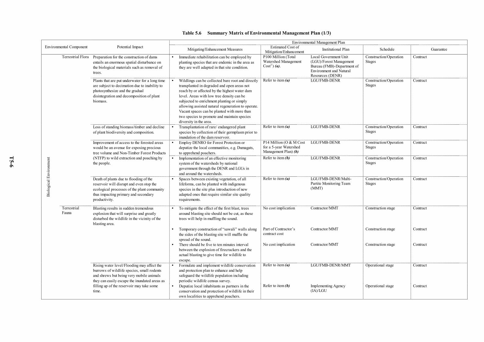
Table 5.6 Summary Matrix of Environmental Management Plan (1/3)
Environmental Management Plan Environmental Component Potential Impact Mitigating/Enhancement Measures Estimated Cost of
Mitigation/Enhancement Institutional Plan Schedule Guarantee
Preparation for the construction of dams entails an enormous spatial disturbance on the biological materials such as removal of trees.
Immediate rehabilitation can be employed by planting species that are endemic in the area as they are well adapted in that site condition.
P100 Million (Total Watershed Management Cost1/) (a).
Local Government Unit (LGU)/Forest Management Bureau (FMB)-Department of Environment and Natural Resources (DENR)
Construction/Operation Stages
Contract
Plants that are put underwater for a long time are subject to decimation due to inability to photosynthesize and the gradual disintegration and decomposition of plant biomass.
Wildlings can be collected bare root and directly transplanted in degraded and open areas not reach by or affected by the highest water dam level. Areas with low tree density can be subjected to enrichment planting or simply allowing assisted natural regeneration to operate. Vacant spaces can be planted with more than two species to promote and maintain species diversity in the area.
Refer to item (a) LGU/FMB-DENR Construction/Operation Stages
Contract
Loss of standing biomass/timber and decline of plant biodiversity and composition.
Transplantation of rare/ endangered plant species by collection of their germplasm prior to inundation of the dam reservoir.
Refer to item (a) LGU/FMB-DENR Construction/Operation Stages
Contract
Employ DENRO for Forest Protection or deputize the local communities, e.g. Dumagats, to apprehend poachers.
P14 Million (O & M Cost for a 5-year Watershed Management Plan) (b)
LGU/FMB-DENR Construction/Operation Stages
Contract Improvement of access to the forested areas would be an avenue for exposing precious tree volume and Non-Timber Forest Products (NTFP) to wild extraction and poaching by the people.
Implementation of an effective monitoring system of the watersheds by national government through the DENR and LGUs in and around the watersheds.
Refer to item (b) LGU/FMB-DENR Construction/Operation Stages
Contract
Terrestrial Flora
Death of plants due to flooding of the reservoir will disrupt and even stop the ecological processes of the plant community thus impacting primary and secondary productivity.
Spaces between existing vegetation, of all lifeforms, can be planted with indigenous species in the site plus introduction of new adapted ones that require similar site quality requirements.
Refer to item (a) LGU/FMB-DENR/Multi-Partite Monitoring Team (MMT)
Construction/Operation Stages
Contract
Blasting results in sudden tremendous explosion that will surprise and greatly disturbed the wildlife in the vicinity of the blasting area.
To mitigate the effect of the first blast, trees around blasting site should not be cut, as these trees will help in muffling the sound.
No cost implication Contractor/MMT Construction stage Contract
Temporary construction of “sawali” walls along the sides of the blasting site will muffle the spread of the sound.
Part of Contractor’s contract cost
Contractor/MMT Construction stage Contract
There should be five to ten minutes interval between the explosion of firecrackers and the actual blasting to give time for wildlife to escape.
No cost implication Contractor/MMT Construction stage Contract
Formulate and implement wildlife conservation and protection plan to enhance and help safeguard the wildlife population including periodic wildlife census survey.
Refer to item (a) LGU/FMB-DENR/MMT Operational stage Contract
Biol
ogic
al E
nviro
nmen
t
Terrestrial Fauna
Rising water level/Flooding may affect the burrows of wildlife species, small rodents and shrews but being very mobile animals they can easily escape the inundated areas as filling up of the reservoir may take some time.
Deputize local inhabitants as partners in the conservation and protection of wildlife in their own localities to apprehend poachers.
Refer to item (b) Implementing Agency (IA)/LGU
Operational stage Contract
T5-6

Table 5.6 Summary Matrix of Environmental Management Plan (2/3)
Environmental Management Plan Environmental Component Potential Impact Mitigating/Enhancement Measures Estimated Cost of
Mitigation/Enhancement Institutional Plan Schedule Guarantee
Reduction of available oxygen underwater thus affecting aerobic dependent organisms including fish and plankton.
Harvest or conduct salvage cutting all the wood or timber biomass that can still be used either for lumber, construction of bunkhouses or source of fuel wood.
No cost implication Contractor Construction stage Contract
The sudden reduction on the volume of water on the lotic ecosystem would directly impact the biology of fish and other aquatic fauna thereby affecting their ability to procreate.
Constant flow of water from dam in terms of volume and regimen be maintained in order to provide breathing space and environment conducive to their existence.
Part of O & M Cost for the Project
IA/MMT Operational stage O & M Monitoring Report
Biol
ogic
al E
nviro
nmen
t
Aquatic ecology
The significant reduction of normal river flows/stream flows of the Agos River into the estuary area would mean increasing the influence of saline environment. The receding influence of fresh water would likely change and even reduce the composition of aquatic fauna.
Maintain the release of water, in terms of volume and regimen, from the dam to reduce the invasion of marine environment in estuary area.
Part of O & M Cost for the Project
IA/MMT Operational stage O & M Monitoring Report
Approximately, a total of 300 hectares of land consisting of agricultural, residential and commercial lands (excluding forestland in reservoir area), will be directly affected by the Project.
Formulation and implementation of Resettlement Plan (RP) for the Project. This Plan shall provide details of compensation package and entitlement for the permanent loss of agricultural, residential and commercial lands.
P1.8 Billion (Total cost of Resettlement Plan) (c)
IA/MMT Pre-construction stage/Construction/Operation Stages
Resettlement Plan
Displacement of a total of 400 PAFs, 79 structures (small huts, toilets, etc.), and 12 institutional and public/communal structures.
Formulation and implementation of a comprehensive RP to mitigate the significant effects of displacement.
Refer to item (c) IA/MMT Pre-construction stage/Construction/Operation Stages
Resettlement Plan
Formulation and implementation of Strategic Communications Program as venue for two-way communication, where government shows its sincere concern for the welfare of the PAPs.
Refer to item (c) IA/MMT Pre-construction stage/Construction/Operation Stages
Resettlement Plan
Conduct participatory community development to mitigate the feeling of exclusion of affected people on a project that directly affects them.
Refer to item (c) IA/MMT Pre-construction stage/Construction/Operation Stages
Resettlement Plan
Undertake income restoration to reinstate the PAP’s standard of living, or uplift/upgrade the existing economic status of the affected PAPs.
Refer to item (c) IA/MMT Pre-construction stage/Construction/Operation Stages
Resettlement Plan
Identification and provision of sustainable livelihood projects through participatory approach and within resources locally available must be undertaken.
Refer to item (c) IA/MMT Pre-construction stage/Construction/Operation Stages
Resettlement Plan
Conduct of vocational skills training for women. Refer to item (c) IA/MMT Pre-construction/Construction/ Operation Stages
Resettlement Plan
Land, Household & Population
Loss of income/livelihood sources of the directly affected PAPs.
Provision of access to financial assistance for projects maybe identified by PAPs.
Refer to item (c) IA/MMT Pre-construction/Construction/ Operation Stages
Resettlement Plan
Soci
o-Ec
onom
ic E
nviro
nmen
t
Indigenous People (IPs)
Impact to the Indigenous People/Communities
Preparation and implementation of the Indigenous People Development Plan (IPDP) to avoid and minimize the negative cultural effects among the IPs through identification and provision of rehabilitation measures.
Cost to be determined during ECC application
IA/MMT Pre-construction stage/Construction/Operation Stages
IPDP
T5-7
Table 5.6 Summary Matrix of Environmental Management Plan (3/3)
Environmental Management Plan Environmental Component Potential Impact Mitigating/Enhancement Measures Estimated Cost of
Mitigation/Enhancement Institutional Plan Schedule Guarantee
Workers, particularly those involved in blasting activities/operations be provided with personal protective equipment to reduce the effect of blasting/explosion.
Part of Contractor’s contract cost
Contractor/MMT Construction stage Contract/ Quarterly Monitoring Report
Health & Safety Potential risks arising from the project during construction phase, especially the excessive noise and vibration that will be generated by the blasting/explosion.
Reduction of working hours and/or introduction of short pauses during the working day may also reduce the blasting effect or consequences.
No cost implication Contractor/MMT Construction stage Contract/ Quarterly Monitoring Report
Prior to construction activities, directly affected barangays shall be provided with advance notice of hiring.
No cost implication Contractor/MMT/Barangay Officials
Pre-construction stage Contract/ Quarterly Monitoring Report
Contractors shall be required to coordinate with the barangay officials.
No cost implication Contractor/MMT/Barangay Officials
Pre-construction stage Contract/ Quarterly Monitoring Report
Availability of significant number of jobs due to the proposed construction and implementation of the Project. Additional employment opportunities are also to be generated for suppliers and subcontractors of the project. Indirect employment opportunities be created for service-oriented activities such as canteens or restaurant business, security agency, etc.
Contractors shall be required to give priorities to the qualified local workforce in hiring.
No cost implication Contractor/MMT/Barangay Officials
Pre-construction stage Contract/ Quarterly Monitoring Report
Additional or associated livelihood opportunities will be created for ambulant peddlers or vendors that will cater to the construction workers such as food and cigarette vendors.
Contractors shall be required to coordinate with the municipal officials in the operation of small businesses in the construction site (e.g., food vending). Contractors shall also be required to give priority to competent or qualified suppliers locally based.
No cost implication Contractor/MMT/LGUs Pre-construction stage Contract/ Quarterly Monitoring Report
Increased revenue collection for the municipalities resulting from the increased economic activities in the area.
Municipalities improve tax collection efficiency especially more business opportunities are expected from the Project.
No cost implication LGUs Pre-construction/construction stage
Contract/ Quarterly Monitoring Report
Soci
o-Ec
onom
ic E
nviro
nmen
t
Socio-economic activities
Future developments such as improvement of access roads or navigation on the reservoir will stimulate human activities in the upper watershed and may further pose threats to the Kanan-Agos Watershed Ecosystem.
So as not to cause any adverse effects to Kanan/Agos basins that are protected areas, planning/design of the project should take into account adequate precautionary measures, e.g., implementation of a comprehensive watershed management plan.
Refer to item (a) IA/MMT/LGUs Pre-construction/construction/ Operational stage
Contract
1/ Includes standard engineering control measures and the use of natural vegetation and bio-engineering measures to retard erosion and soil stabilization.
The Plan is to complement the existing Kaliwa Watershed Rehabilitation and Management Project of the FMB-DENR.
T5-8
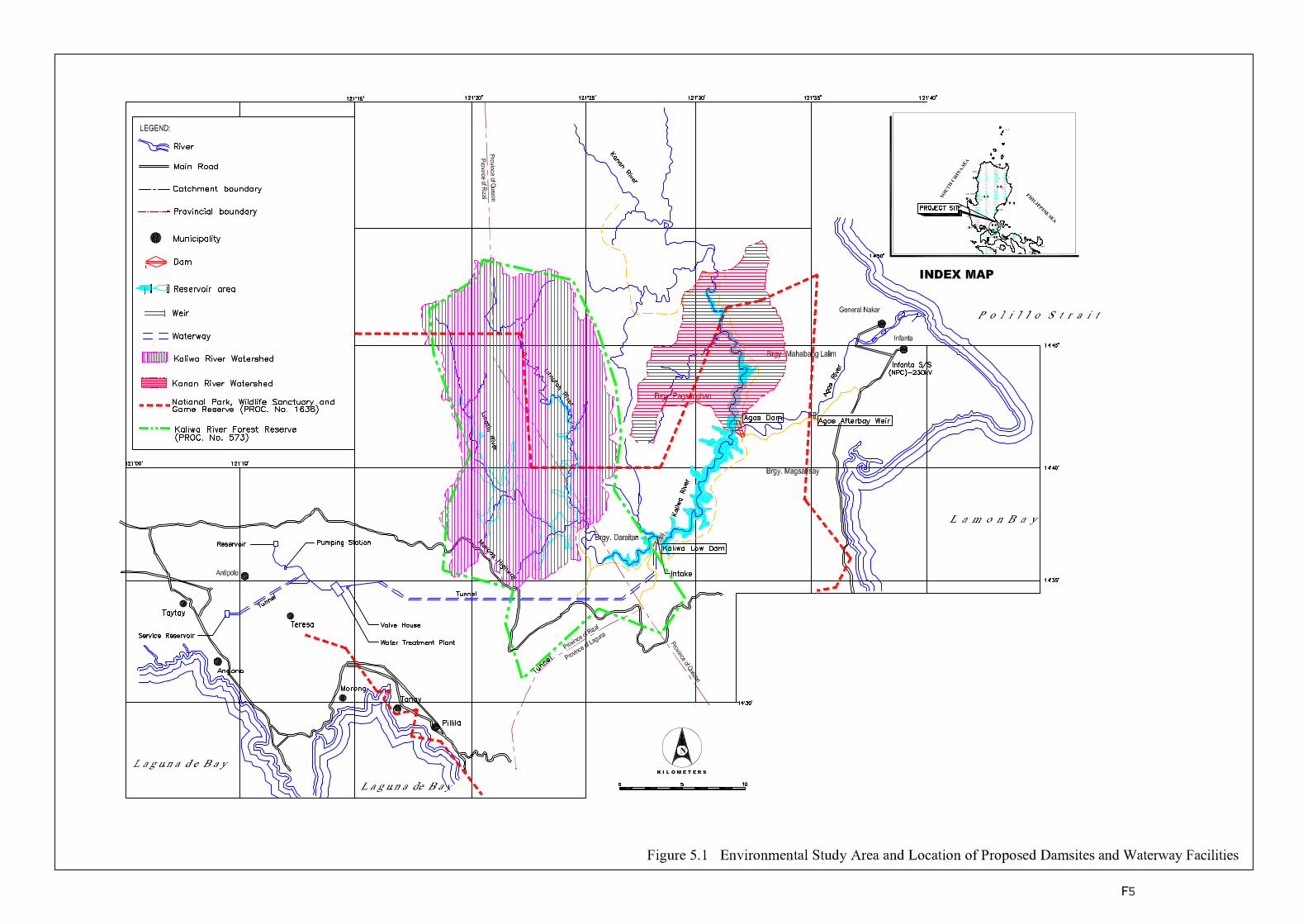
5 1
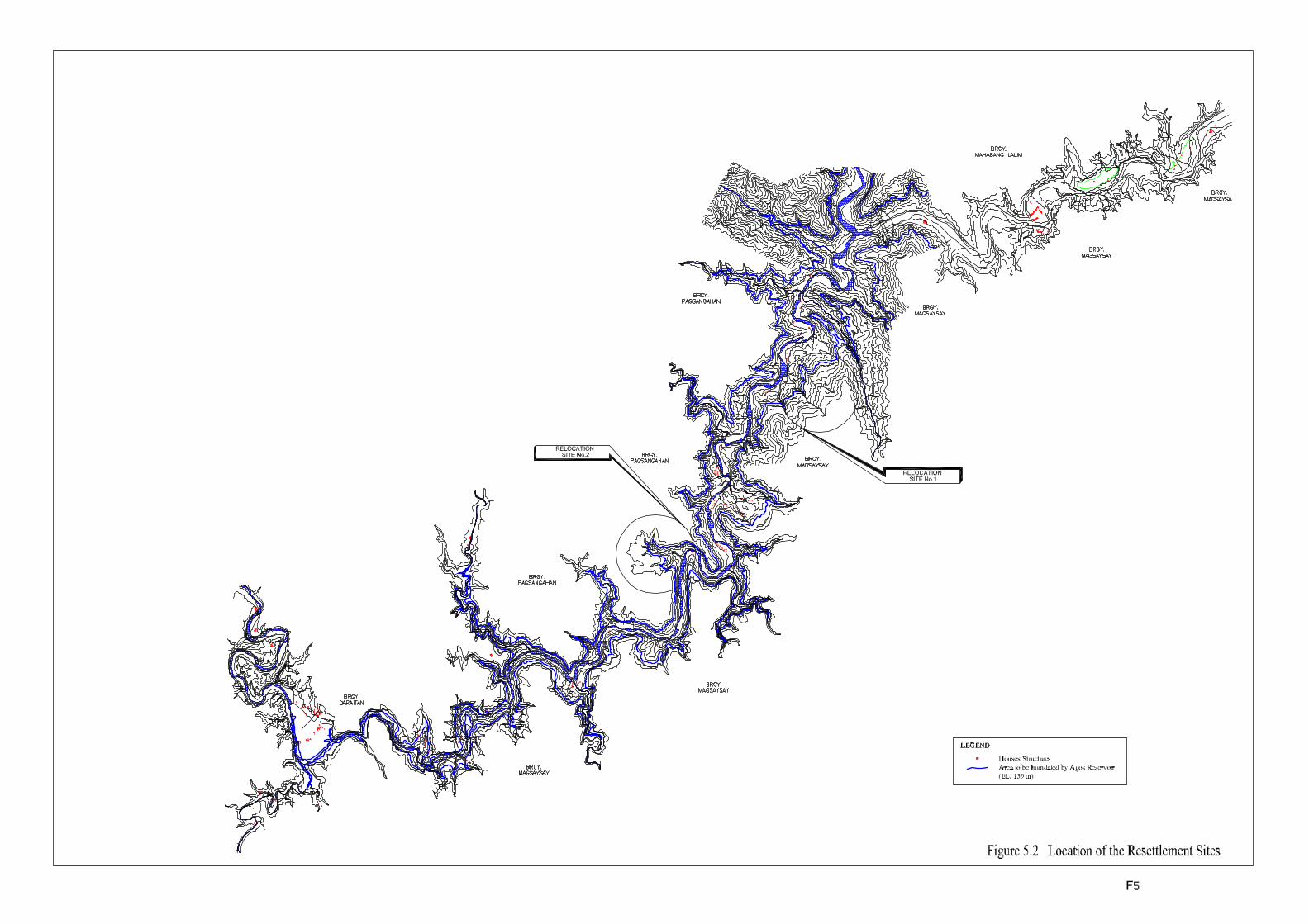
5 2