chapter1: the earthxa.yimg.com/kq/groups/23147588/580850099/name/ch… · web viewchapter1: the...
TRANSCRIPT

Chapter1: The earth The third planet of the solar system is the only planet which supports life; the earth is nearly a closed system. The earth’s surface is where four immense open systems interface or interact. There are three a biotic systems i.e. non living systems over lap to form the realm of the biotic system of the living system.
The biotic spheres are the atmosphere and lithosphere. The biotic sphere is called the biotic system because these four models are not independent units in nature, their boundaries must be understood as transitional zones rather than sharp delimitations. Atmosphere The atmosphere is a thin gaseous veil surrounding the earth, and held to the earth by the force of gravity.
Hydrosphere: earth’s waters exist in the atmosphere on the surface and in the crust close to the surface of the earth in liquid, solid and gaseous forms. Water occurs in two forms fresh water and saline (salty). The water flows through rivers seas, oceans and lakes.
Lithosphere: This forms the earth’s crust and portion of the upper mantle which is directly below the crust this forms the lithosphere. The crust is quite brittle compared to the layers beneath it, which are in motion in response to an even distribution of heat and pressure. The lithosphere is some times thought of as the entire solid planet.
Biosphere: The life layer. The biosphere exists in the overlap among the biotic sphere extending from the sea floor about 8 km into the atmosphere the limit between which life is sustainable. The biotic sphere is called the biosphere.
The shape of the earth: the shape of the earth is a flattened sphere or oval there has been so much research done on earth – science to prove its spherical shape. Earth
has for example a circumference of about 40076 km, polar circumference 40008 km, equatorial diameter 12,757 km; polar diameter is 12, 713km.
This simply shows that the earth is not a perfect sphere it is a little flattened at both ends like an orange. It can be called a geoid i.e. earth shaped. The spherical shape of the earth is also masked by the intervening high lands and oceans on its surface.
Evidences to prove that the earth is spherical Aerial photographs: photographs taken by satellite at the great distance all show that the earth’s surface is curved.
Sun rise and sun set: The sun rises and sets at different times in different places. The earth rotates from west to east, which means that places in the east see the sun earlier than those in the west. If the earth was flat the whole worlds have sun rise and sun set at the same time.
The lunar eclipse: the shadow cast by the earth on the moon during a lunar eclipse is always circular. It takes the out line of an arc of a circle. Only a sphere can cast a shadow which is round or circular.
Circumnavigation of the earth: The earth has been circumnavigated many times by Land Sea and air. The first voyage around the earth was made by Magellan and his group between 1519 and 1522. He sailed from Seville in Spain in 1519 A.D. and completed their voyage at the same place three years later by Del Cano in 1522. This voyage proved beyond doubt that the earth is round.
The earth’s curved horizon. The earth’s horizon when seen from a ship, a plane or a high cliff, appears curved. The curved horizon widens as the observers attitude increases until it becomes circular. This is how astronauts see the horizon from their

space ships. If the earth was not spherical, there would be no circular horizon.
Fig 1.1 earth’s curved horizon
A ship’s visibility: When a ship appears over at the horizon at a great distance it appears to be sinking slowly beneath the water level, the explanation lies in the fact that the sea surface curves down wards away from us.
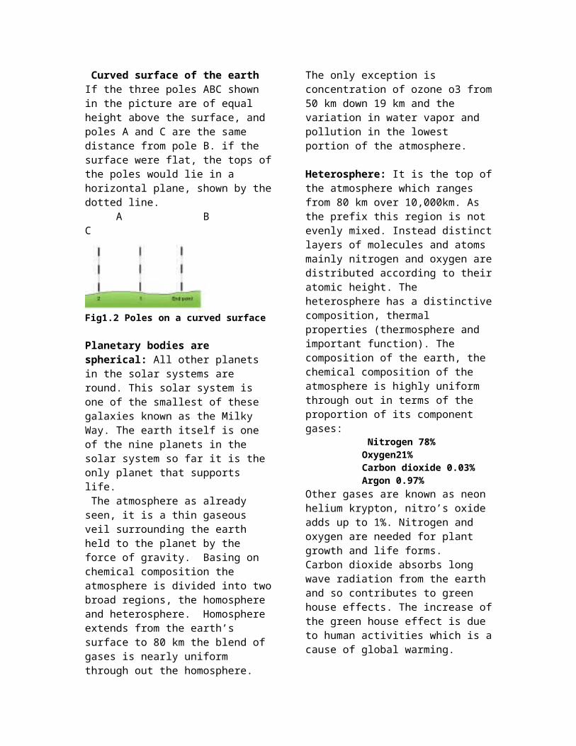
Surveying with poles on level ground: Poles of equal length when driven into level land, at equal intervals, do not give a perfect level. The centre poles at either end. This is caused by the curvature of the earth as shown in the fig. below. If the earth was flat , the tops of all the poles would lie on the line of sight.
Curved surface of the earth If the three poles ABC shown in the picture are of equal height above the surface, and poles A and C are the same distance from pole B. if the surface were flat, the tops of the poles would lie in a horizontal plane, shown by the dotted line. A B C
Fig1.2 Poles on a curved surface
Planetary bodies are spherical: All other planets in the solar systems are round. This solar system is one of the smallest of these galaxies known as the Milky Way. The earth itself is one of the nine planets in the solar system so far it is the only planet that supports life.
The atmosphere as already seen, it is a thin gaseous veil surrounding the earth held to the planet by the force of gravity. Basing on chemical composition the atmosphere is divided into two broad regions, the homosphere and heterosphere. Homosphere extends from the earth’s surface to 80 km the blend of gases is nearly uniform through out the homosphere. The only exception is concentration of ozone o3 from 50 km down 19 km and the variation in water vapor and pollution in the lowest portion of the atmosphere.
Heterosphere: It is the top of the atmosphere which ranges from 80 km over 10,000km. As the prefix this region is not evenly mixed. Instead distinct layers of molecules and atoms mainly nitrogen and oxygen are distributed according to their atomic height. The heterosphere has a distinctive composition, thermal properties (thermosphere and important function). The composition of the earth, the chemical composition of the atmosphere is highly uniform through out in terms of the proportion of its component gases: Nitrogen 78% Oxygen21% Carbon dioxide 0.03% Argon 0.97%Other gases are known as neon helium krypton, nitro’s oxide adds up to 1%. Nitrogen and oxygen are needed for plant growth and life forms. Carbon dioxide absorbs long wave radiation from the earth and so contributes to green house effects. The increase of the green house effect is due to human activities which is a cause of global warming.
Water vapor, water vapor is a primary source of atmosphere moisture and plays a vitalrole in cloud and fog formation through the process of condensation and precipitation. Water vapor absorbs in coming radiation and keeps global temperature constant. It is essential for life on earth. Water vapor is introduced to the atmospheric surface by evaporation and returned to the earth surface
mainly through various forms of precipitation e.g. rainfall hail storms.
Dust particles: Originated from dry desert plains, lakes, beds, explosive, and volcanoes Absorbs reflects incoming radiation, and then forms condensation nuclei which is necessary for cloud formation. The dust particles contribute to the occurrence of twilight and red colours of sun rise and sun set. Other sources of dust particles are terrestrial dust, pollen grains and other air pollutants. Air pollutants include sulphur dioxide, nitrogen oxide, and methane from industry, power stations and car exhausts. Based on temperature, the atmosphere is divided into 4 parts according to zones of temperature changes. The zones are as follows: a) Troposphere b) Stratosphere c) Mesosphere d) Thermosphere. The troposphere: Is the nearest to the earth surface. It consists of gases, dust and water vapor. It is the sphere of weather and life. Temperature in the troposphere decreases by 6.5 degrees Celsius with every 1000 m increase in altitude i.e. the environmental lapse rate. All vital atmospheric process which create the weather conditions on earth surface occur in the troposphere.
The tropopause: An undefined region between the troposphere and stratosphere. It forms the upper limit to the earth’s climate; weather is marked by the Iso thermal layer. It is here where temperature remains constant despite any increase in height.
Stratosphere (up to 55km) from the tropopause .It is characterized by a steady increase in temperature with the temperature inversion caused by convection of ozone 03. This gas absorbs in coming ultra violet UV radiation from the sun. Ozone is a photo chemical process resulting from the reaction of ultra violet radiation up on ordinary oxygen. The ozone layer serves as a shield protecting the tropopause and the earth’s surface by absorbing most of the ultra violet rays from the sun rays. The ultra violet rays, on reaching the ground may destroy bacteria, plant and animal
tissues since the water vapor content of the atmosphere is a negligible amount in the atmosphere. The weather is very sunny and stable.
Stratopause: This is the upper limit of the stratosphere. This is another ISO thermal layer where temperatures do into change with increasing height.
Mesosphere (50-80km): It is the coldest zone of the atmosphere, the temperature falls rapidly as there is no water vapor, cloud cover, dust or ozone to absorb the incoming radiation. This layer experiences the lowest atmospheric temperatures and the strongest winds.
Mesopause: A transitional zone between the mesosphere and thermosphere .It shows changes in temperature
The thermosphere is 80km and more in to space. Temperature rises rapidly with height; perhaps to reach 1500 C due to an increasing proportion of oxygen in the atmosphere, which like ozone absorbs incoming ultra violet radiation. The thermosphere is divided into two parts i.e. the ionosphere which is a layer of electronically charged particles of irons of electricity and free electrons which reflects radio short waves. The ionosphere is up to 400 km up. This layer protects the earth from falling.
The exosphere (beyond 965 km) Above the ionosphere is the upper most zone of the atmosphere. It is the outer most zone of the atmosphere. It is also known as diffusion zone where the atmospheric gases diffuse into the open space. It is extremely dark; it is here where the modern satellite balloons launched in the upper strata are caused to transmit back to the earth information regarding earth conditions
In the atmosphere particularly the troposphere, every day thousands of tons of pollutants are discharged into the air by cars, factories and airplanes, incinerators, (a is a

machine for burning un wanted things). Other natural sources of air pollution are from ash, from volcanic eruption, gaseous emittions, smoke from forest fires and wind blown dust. These are widely dispersed through out the atmosphere. How ever they don’t have a significant long term effect on air. Two specific zones of the atmosphere are identified on the atmosphere are identified on the basis of function for their role in removing most of the harmful wave length of solar radiation. These zones are the ionosphere and ozone sphere
Theories of the origin of the earth; the theory of Continental driftAlfred Wagner and F.B Taylor were the two men who put forward their theories inexpertly at the beginning of the 19th century. The term continental drift refers to large scale differential movements of the outer shell of the earth that is the crust and a part of the mantle. The present distribution of continents was regarded as a result of fragmentation by rifting, followed by a drifting part of individual masses of that broken outer shell (i.e. the silica crust). The two men put the theories independently at the beginning of the last century.
According to Wagner the world was made up of one super continent which he called the Pangea. It was surrounded by a super ocean called Panthalansa. Pangea was located around the South Pole near the present day South Africa. It was about 280 -200 million years ago between carbonation and cretaceous periods Pangea began to drift North wards.
In about 135 million years ago Pangea split into two blocks. That is Laurasia in the north and Gondwanaland land in the south. Between the two blocks that had split was the sea of Tethys (which is the present day the Mediterranean Sea).According to Wagener a vertical rift developed through Gondwanaland land which widens to become an Atlantic ocean. On the Eastern side and the southern side, India Australia
and Antarctica also broke off to create the Indian Ocean basin.
Evidences of continental drift Similarities in geological structure that are now separated by large expanses of water e.g. Brazil and West Africa.
Similarity of fossil remains of ancient forms of life; found on separate continents. The classic example is the dinosaurs whose remains have been found only western S American and South Africa. Also the Appalachians Mountains of the eastern United States America corresponds geologically with mountains in North West Europe.
Climatology Coal formed under warm wet conditions is found beneath the Antarctic ice caps and evidence of glaciations had been noted in tropical, Brazil and central India.
The Jigsaw and visual fitting of the south continents particularly the east of the south continents particularly the east coast of Brazil into Guinea coast of Africa.Drawing
Mid- Atlantic Ocean ridge.Accurate mapping of the ocean floor carried out by U.S scientists in 1950’s shows ridges and mountains – chains of 75,000km long under world’s oceans for e.g. the Atlantic rides is about 1000 meters wide and rises to 2,500m in height. The location of these ridges had to be related to the spreading of the continents
The Atlantic Ocean between Africa and South America is even systematically divided into by the Atlantic mid- ocean ridge. The identical geological sequence of strata; in the karoos series of South `Africa and that of South America. The Carboniferous glacial deposits which are similar in South Africa; South America South Australia and India.
Laterites soils develop only in the tropics under a conducive climate, hot and wet, but

today the fact that laterites are found in the temperate regions is good evidence that there was a drift. These laterites deposit could only have formed when it was a single block Pangaea locating in the South Hemisphere and are just preserved in the temperate region we find the late rites deposits of the carboniferous error in North America Britain German Russia China.
Palaeo- magnetism In the recent studies we are enabling to know the times at which the rocks were formed to be accurately calculated. When rocks of different continents solidify they are magnetized in the direction of the magnetized in the direction of the magnetic North pole at that time. By studying magnetism of rocks it is possible there four to determine where on the earth surface rocks were originally formed. For example during under water volcanic eruptions, basaltic lave intruded into the crust and cooled there. During the cooling process, individual minerals especially iron align themselves along the earth’s magnetism field i.e. in the direction of magnetic North pole.
Paleontology – the rocks have a lot of similarities in flora and fauna. For example the Amazon forest and the Congo forest in Africa seem to be one in continuous with the other. The Amazon River seems to be continuing with river Congo in Africa. On the fauna – for example the elephant and the Asian Elephant are the same only a few differences the Asian Elephant is friendly and has only three toes while the African one is hostile because of the environment it has been always hunted for its tusks while the later is kept a t home as a domestic animal and commonly used as means of transport in India.
The coral reefs evidence: today we find coral rocks in the green land Siberian and other cold environments where coral cannot grow. This points to the fact that coral had already grown , it only grows under tropical condition where the water is warm well lite
by sun , clear clean water so it only drifted along the block and has been preserved by cold environment .
Sea floor spreading theoryThis is one of the modern theories of continental drift. It was propounded by an American Geologist called Henry Hess. Hess observed the nature of the Atlantic ocean basin floor . He observed for instance that mid- way between America and Africa there is a mid ocean ridge. In 19 62 he studied rocks from this mid-ridge. To the coast of North America he found that away from the mid –ocean ridge, the rocks become older. He explained that the young rocks at the mid oceanic ridge must be replacing away the older rocks, leading too the spreading of the sea floor of the Atlantic.He suggested that the interior of the earth behaves like a giant convective cells, which rise from the interior and spread out horizontally beneath the ocean floor, causing rifting. New rocks are deposited at the rift, displacing the older rocks side was. According to Hess such new rocks were being deposited in ice land and that sea floor spreading is taking place at a rate of up to 5 cm every year.
Fig1.3 sea floor spreading;
Critics say that one big problem with the theory is that it gives the implication that the earth must be increasing in size. i.e. if the ocean floors were increasing in size , then the earth must also be increasing in size. Unfortunately, Hess had studied only the Atlantic floor and; while he did not find out what was happening to the other ocean floor. How ever investigations were done to find out what was happening in the rest of the ocean floor. This has led to a new theory that was developed in the 1970s and the 1980s this is the theory of plate tectonics.

Plate tectonics theory: This is said to be the most universally accepted theory; which explains the continental drift and the distribution of continents and ocean basins.According to this theory the earth crust was divided into a series of rigid plates (seven large plates) which float like rafts in a semi fluid state. Convectional currents from the interior drag the plates along , so that where the currents are converging , the plates collide and where the currents are diverging away from in opposite direction the plates are drift apart and in some areas , along the coast or the north American the plates slide past each other.
In general there two plates moving away from each other; while the plate boundaries are described as constructive margins because the old rocks are sub ducted and destroyed .(or where continental crust are colliding , the old rocks are crumpled into fold mountains).At transcurrent (wrench) faults, plates slide past each other and their plates boundaries are described as conservative margins because the crust is neither created nor destroyed.As a result of the convection cells generated by heat from the earth, plates may move towards or away from or side ways along adjacent plates. And South American plates – trenches are a formed like the Peruvian trench i.e. the Marianna and the Japan trench. Continental – continental convergence; Involves collusion of two continental forming fold mountains. The collision of two continental plates and the Indian plate formed the Himalayas Fold Mountains of the Alps and the Atlas Mountains.
Constructive margins; occur where two plates move parallel or nearly parallel to each either in opposite direction or it is when two plates slide past one another. Although frequent small tremors may occur as a result of plates between the plates is said to be conservative because crustal rocks
are there. The boundary between the two plates is characterized by transform faults.The San Andreas’fault is the most notorious of several hundreds of years known transform faults I the California. It was formed when the pacific plates of America n plate slide past each other.
The Atlantic Ocean was formed as the plate of Laurasia splitting in to two, in a process that may be repeating it’ self in East Africa. Here the brittle crust has fractured as a section moved a part the African rift valley associated with volcanic activities. In Africa the rift valley extends for 4000, Kilometers from Mozambique to the Red sea.
Convergent boundaries or destructive plate margins; These are areas where two plates collide resulting in deep ocean trenches, violence eruptions and the creation of folded mountains. Three types of converging plates are recognized. Ocean –convergence; The descending plates initiatives volcanic activities on the ocean floor causing dry land to emerge from the ocean depth. Volcanic islands or arc are the Aleutian, Mariana and Tong Islands. (Tonga-Kermode deep sea trenches).
Oceanic continental convergences; this happens when continental oceanic plates collide. The oceanic plates being dense sink (subside) beneath the continental plates features resulting on the continents like volcanic cones.The Andes Mountains are said to be a result of collision between Nazaca plates. All major interactions between plates occur along boundaries. These are the margins where most of the earth seismic activity volcanic and mountain building occurs.
Types of plates BoundariesDivergent boundaries or constructive margins ridge boundaryWhere plates move apart result in up welling of mantle this creates new sea floor
Convergent boundaries or destructive boundaries (subduction zones)
Where plates move towards each other in opposite direction but at different rates, with out causing any creation or destruction of lithosphere a own as constructive or passive margins. N.B Tectonics refers to the deformation of earth’s crust as a result of internal which can form various structures to the lithosphere the tectonic results into folds faulting and warping and some times volcanic.
Divergent boundaries: this is a characteristic trend of the sea floor spreading centre, where up welling materials forms the mantle forms new sea floor. And crustal plates are spread apart. As plates move with molten rock a new strip of sea floor and volcanoes. The best example is the mid – Atlantic ridge. It is said that America is moving away from Eurasian and the African plates. While East Africa is rising due to the pacific plates which are moving apart.The largest visible product of the constructive divergent plates is the Ice land where one third of the lava emitted on to the earth’s surface in the last 500 years can be found.
Table 1.1 The major land forms resulting from plate movements:Types of plates
Description of changes
Examples
A. constructive margins (spreading or divergent plates)
Two plates move away from each other. New oceanic crust appears forming mid ocean ridges with volcanoes
Ridge (American moving away from Eurasian Na d African plates. East pacific rises (Nazca and pacific moving apart).
B. Destructive Margins (subduction
Oceanic crust moves towards
Nasca sinks under South
zones ) continental crust but being heavier sinks and is destroyed forming deep sea trenches and Island arcs with volcanoes.
American plate (Andes), Juana de Fuca sinks under North American plate (Rockies) Island arcs of west Indies and Aleutians.
C. Collision zones
Two continental crusts collide and as neither can sink are forced up into fold mountains.
Indian plate collided with Eurasian plate Himalayas and the African plate collided with the Eurasian plate forming the Alps mountain.
D, Conservation or passive margins (margins faults)
Two plates move sideways past each other. Land is neither formed nor destroyed.
San Andres faults California.
No one knows with certainty what drives the crustal plates. There are assumptions that heat driven convection is the likely cause, how ever gravity driven seduction may be the primary driving force.

Convection currents: originate from the atmosphere zone of the upper mantle. The magma is kept in a semi- molten state due to very high temperature of about 5000 degrees C. Such high temperatures generate convection currents, convection refers to the mass movements of a fluid as a result of differences in temperature and there four differences in densities with in the fluid.
Convection cells: These are circulating cells created by differences in temperature density with in the asthenosphere of the mantle. Convection cells develop as hot mantle materials rises from the earth’s interior it moves in a lateral direction then it cools and begins to sink. These slowly turn convection cells in the plastic asthenosphere drives the plates. According to this hypothesis, hot fluid materials from the mantle rise at diverging boundaries.Some of the materials escape to form new crust but most of it spread s out beneath the lithosphere. As it moves below the lithosphere it drags overlaying plates with it.
Hot spots are sites where plumes of hot rock materials raise from deep with I the mantle. Occur beneath the oceanic and continental crust and appear to be deeply anchored in mantle tend to remain relative to migrating plates. N.B Broad convection cells are fuelled by heat from the core.
Mantle plumesThese are narrow columns of rising hot directions where mantle plumes intersect the surface of the earth, hot spots are produced. The hot spot does not appear to move over them causing the hot spots to leave trials of geo thermal activity, lava flows and up lift. It is thought that the radical energy flows out wards from the hot spots plays apart in the breaking up of the crustal plates and setting them in motion gravitational energy is the down ward pulling returning the higher density crust to the mantle.
Pull of gravity
Gravitational force refers to the force of attraction between heavy bodies. These forces exact pull and push stresses on plates. Gravitational forces lead to subsidiary (sinking) heavier oceanic plates sections down under continental plates, allowing light materials to distill off as it subsides. This would produce a pulling force where plates are in collision.
Rotation of the earthThis tends to exert centrifugal force i.e. the pull apparent force that appears to pull an object away from the centre of rotation as a result plates pulled into opposite direction at one point.
The critics say a number if objections have been made for instance the evidence of thermal convection in the mantle is usually considered as driving force for plate motion. As present it is believed that the driving force for plate motion. At present it is that the driving force in the displacement of plates is not thermal but thee thermal gravitational currents.The assumption of pushing down of solid lithosphere into mantle to a depth as much as 700 km is not adequately substantial.
The continental drift hypothesis has not so far produced any reasonable interpretation concerning the planetary net work of long –living deep faults common to continents and oceans.
Theory of isostacy The term isostacy comes from Greek words iso which means equal and stotikes means balance. The word isostacy means equal balance or equal standing. The theory of isostacy was proposed by an American geologist Clarence Dulton in 1889. Dulton’s theory states that when ever equilibrium exists in the most earth’s crust equal mass must under lie.
The theory of Isostacy states that when ever equilibrium exists in the earth’s crust equal mass must under lay earth’s surface, which means that a great part of the continental

mass must be formed by lighter materials than that which is supposed to constitute the ocean floor. Thus there exists a gravitational balance between crustal segments of different thickness. The very extensive columns form features like mountain ranges, elevated lands where as the short columns make plains and basins.
Due to gravitational forces elevated areas on the earth’s surface are subject to erosion and the eroded material is deposited on lower areas. Erosion reduces weight of respective column. The deposited material increases the weight of the column in which it is deposited.The gravitation force alters the state of equilibrium (Isostatic –equilibirum) of columns. Despite these altering forces the equilibrium is maintained / adjusted i.e. isostatic adjustment. Currently the theory is based on equilibrium between the earth’s crust and the mantle layer.
Since crustal rocks are less dense than the mantle rocks the crust can be thought of as floating on the mantle just like the way wood would float on water. If the weight of sial (continental crust is increased in one area by volcanic eruption delta deposition may cause sinking /deposition of the crust.
Also if the weight of continental rock in an area is decreased by long term denudation, the reduced weight causes up lift. Therefore isostacy is based on erosion and deposition processes, where by erosion causes up lift where as deposition causes sinking. This vertical unloading and loading to reach equilibrium is called isostatic adjustment. These take place extremely slowly over thousands of years but they maintain the balance between oceans and continental rocks. Isostatic adjustments involve two movements of adjustment.
Movement in vertical direction
For example as ice caps formed the weight of ice may have caused the sinking or
sagging of the crust and when the ice is melted so it gradually recovered, producing considerable changes in the level of the land and relative to that of the sea. This adjustment is known as glacial isostacy adjustment and glacial eustatic adjustment. Example of isostatic adjustment include, the Pleistocene glacial period, when Britain was depressed by the weight of ice. Following deposition when ice melted, the land slowly raised again thus isostatic up lift.
At the beginning of the glacial period; water stored as ice on land resulted in the fall of the sea level, because the weight of ice increased on depressing the earth’s crust beneath it. Later when the ice sheets began to melt large quantities of water previously held in storage were returned to the sea and the level rose. As a result there was up lift on the land as thee weight of ice decreased. This change created raised beaches and caused rejuvenation of rivers e.g. the raised beaches of Scotland.
Movement in the horizontal direction: Involves sort of slow horizontal flow or convection currents in the asthenosphrere, when deposition of materials occurs.
The theory attempts to explain what makes high mountains or deep sea depressions continue to exist over time; despite the pressure of continental processes of erosion and deposition respectively. Today, the idea of floating blocks of the crust forming mountains as adjacent areas sink from the weight of sediment that has been replaced by a different model. It is the plate tectonics model which considers the motion of large plates of crustal floating on the asthenosphere.
How ever isostacy still remains an important concept in understanding most of these plates. These isostatatic adjustments take many years to occur e.g. when snow melts on mountains range one can see emerging land. .Critiques say isostacy (convincingly) explains the vertical up lift of mountain but

it has not yet been established that isostacy is the factor initiating tectonic movements. Its role is rather moderate and not decisive.
Exercise1. Define Isostacy and then
differentiate it from the other theories of origin.
2. Describe the theory of Plate tectonics
3. With the help of diagrams describe the major land forming processes discussed in the theory of sea floor spreading.
4. Discuss the evidences to prove that the earth is spherical
Summary Earth is nearly a closed system. The earth’s surface is where four immense open system interface of interact. The biotic sphere is called the biotic system because these four models are not independent units in nature, their boundaries must be understood as transitional zones rather than sharp delimitations. The atmosphere is a thin gaseous veil surrounding earth, held to the planet by the force of gravity. All other planets in the solar system are round. This solar system is one of the smallest of these galaxies known as the Milky Way. There are evidences put down to show that the earth is not flat but spherical and then some of the theories that explain the origin of the earth.
Chapter 2: The structure of the earth

Volcanic eruption, deep mines, boreholes, and earth quakes all give clues of the nature of the earth’s interior, which is made of three parts. The core, the mantle, and the crust, there are water bodies such as oceans and seas, while in the atmosphere is composed of gases.
The concentric zones of the earthPlanet earth has three layers: the crust, the mantle and the core. The upper crustal layer is made up of rafts of sial (silica and aluminum) rocks which are light. They are floating on the sea of sima (silica and magnesium) rocks which are heavy.The earth is made up of continents and oceans; these are composed of rock types known as granites with a density of 2.7. Beneath the continental block is the layer of basalt which lies at a much greater depth than it does beneath the ocean basin.
Fig 2.1 A sectional view of the three zones of the earth that is the core, mantle and the crust
Variations in the density and thick ness of the concentric zones of the earth’s crustThe continental crust: This is the outer the outer most layer with an average of 65 km in thickness. The crust density of 2.7 gm/ cc silica of about 65 – 75% and aluminum of about 25%, thus collectively they are known as sial si stands for silica and al stands for
aluminum.The core has a density of 2.7 and the liquid core is much heavier than the outer shell. The outer part of the core is 1800 miles below the earth’s surface, to 3,160 miles.
Characteristics of the earth’s crust, mantle and core The crust is known as the lithosphere. It is the outer shell of the solid Earth and has two subdivisions: continental crust and oceanic crust. Continental crust is the solid materials (rocks) that form the continents (SIAL rocks) and the oceanic crust is the rocks that form the ocean floor.
The oceanic crustThis is the lower continuous layer, 6–10 km in thickness, beneath the continents and the basins. It is made up of dark and heavy or high density rocks of between 2.8 and 3.0 g/cm3. These are basic rocks, containing more than 50% silica. The oceanic crust also contains ultra basic rocks, with 40–45% silica. The rocks of the oceanic crust are heavy rocks made up of silica and magnesium, for example basalt rocks. They are collectively known as SIMA: SI for silica and MA for magnesium.The rocks forming the Earth’s crust are granites and basalts and have a thickness of 20–25 miles (30–40 km). The boundary between the crust and the mantle is sharp, and is known as the Mohorovičić discontinuity or Moho in short.The Earth’s crust is very thin compared to the core and the mantle combined, but it is on the crust that all the features of the Earth are found. The mantleThe mantle is found beneath the Mohorovičić discontinuity. It comprises denser rock with an

average density of 3.3 g/cm3. The mantle rocks are less rigid and more plastic in nature than those above and below this level. This layer is referred to as the asthenosphere. In contrast to the lithosphere above it, the rocks of the mantle are in a semi-molten state and are capable of slow movement. This is because of the extreme heat and pressure in this zone.
The coreThe core is subdivided into a liquid outer portion (outer core) and a solid inner portion (inner core). Materials of the outer part of the core lack rigidity because they are more liquid and have temperatures ranging between 4000 and 5000°C. In contrast, the inner core, which begins 3160 miles below the surface, is solid because of the high pressures it is subjected to and has a temperature range between 5000 and 6000°C. Both solid and liquid portions of the core are made of iron, nickel or silica.Scientific studies indicate that large areas of the outer crustal layers are made of basaltic rocks. They are found on the ocean floor of the Indian Ocean and the Atlantic Ocean.
Variations in density and thickness of the concentric zones of the Earth’s crustThe Earth’s crust is of two types:1. The continental crust, which is older and lighter. It cannot sink and is permanent.2. The oceanic crust, which is younger and heavier. It can sink and is constantly being destroyed and replaced.The continental crustThis is the outermost layer and has an average thickness of 65 km. The crust has a density of 2.7 g/cm3 and contains 65–75% silica and
25% aluminium. Silica and aluminium are collectively known as SIAL: SI for silica and AL for aluminium.Note: The crust is made up of several large and small segments, called plates, which float on the mantle.
The mantleThe mantle has a thickness of about 1800 miles (2900 km) and its density increases with depth. The uppermost section of the mantle is called lithospheric mantle, which is solid and brittle. At the base of the mantle is an important feature, a thin layer between 100 and 200 km below its surface called the mesosphere: therefore the mantle is made up of three sections/zones, i.e. the lithospheric mantle, the asthenosphere and the mesosphere.The asthenosphere lies below the lithosphere, at depths between 100 and 200 km (~ 62 and 124 miles) below the surface, but perhaps extending as deep as 700 km (~ 435 miles).In spite of its heat, pressures keep it plastic, and it has a relatively low density.The rigid lithosphere is thought to “float” or move about on the slowly flowing asthenosphere, creating the movement of crustal plates.
Types of rocks of the earth‘s crust:-A rock is a naturally occurring agglomeration/combination of mineral particles forming part of the Earth’s crust. Rocks can be classified according to their age, physical and chemical characteristics and mode of formation.Rocks form the solid part of the Earth. There are three types of rocks based on their mode of

formation: igneous, sedimentary and metamorphic rocks.
Igneous rocksIgneous rocks are formed by solidification of molten rock known as magma. Magma comes from the deep part of the mantle where the temperature and pressure are very high. This causes rocks to melt and move upwards towards the surface of the Earth. Magma may solidify either within or outside of the Earth’s crust. Therefore, igneous rocks are a result of volcanic activity – when magma cools, the crystals that are produced form igneous rocks.
Types of igneous rocks Igneous volcanic rocks form on the surface of the Earth. The magma cools fast and forms small crystals. Igneous rocks are of two main types:
Plutonic rocks are formed from deep in the crust. The rate of cooling is slow and therefore they form large crystals, for example in granites and batholiths. They may be exposed to the surface by prolonged erosion.Hypabyssal rocks are formed in the Earth’s crust. Dolerite and porphyry are rocks with large crystals in a fine grained matrix structure e.g. dolerite and porphyry.Pyroclasts are air born fragments of volcanic materials produced during volcanic activity. Tephra is loose fragmental material produced during eruptions which remains loose on the ground un less hot enough to fuse together to produce tuff or pyroclastic rock.
Characteristics of igneous rocks
• They are formed by the cooling and solidifying of magma, either within or on the Earth’s crust.• They contain crystals.• They do not contain strata (layers), because they form by the cooling and solidification of molten rock.• They do not have fossils (plant and animal remains). Examples include basalt.
Fig 2.2 igneous rocks Sedimentary rocksThe term ‘sedimentary’ means settling. These rocks are sometimes known as stratified rocks because they usually have layers, or strata. Sedimentary rocks are formed by deposition and accumulation of sediments. Broken materials from pre-existing rocks are transported by water, waves, wind or ice, and are eventually deposited or laid down in great thickness. Over time, these sediments are compressed and they harden into rock layers. The plane/zone that separates one layer from the next is called a bedding plane or plane of stratification.
Fig 2.3 Stratified rocks laid down in water Classification according to the mode of formation

There are three categories of sedimentary rocks according to their mode of formation.
Mechanically formed sedimentary rocks are composed of small rock fragments that are derived from existing rocks through agents of soil erosion and denudation. These are transported and deposited in layers of various thicknesses on land or in water. These materials, such as clay and gravel, become cemented under pressure and harden to form very hard rocks. Loess is an example of continental deposits deposited by wind, alluvium by river deposition and moraine by glacial deposition.
Organically formed sedimentary rocks are formed from the remains of dead organisms which decompose and accumulate to form coral rocks, limestone and coal. Corals and limestone are made from animal skeletons, while coal, peat and lignite are made from partly decayed plant tissues. This category of sedimentary rock has major sub-classes, such as siliceous, ferruginous, calcareous and carbonaceous.
Chemically formed sedimentary rocks are evaporated from solutions of salty sea water and also lake water that is rich in dissolved salts. They are also formed by the deposition of soluble salts, lime and other chemicals such as soda ash, for example rock salt found in Lake Magadi. When it rains or when the land is irrigated, minerals in the soils are dissolved and transported in solution into water bodies. This is followed by the evaporation of water from the sediments, leaving the minerals behind. The
accumulated mineral sediments are later compressed to form a rock. In hot regions, the resultant rocks are called evaporites. Examples of minerals forming this type of sedimentary rocks include gypsum, flint, limonite, trona (soda ash), and dolomite.Metamorphic rocks
Metamorphic rocks are igneous or sedimentary rocks that have been subject to heat and pressure which has changed their physical or chemical composition. The degree of change, however, depends on factors such as resistance of the rock to crushing, grain size of the rock, porosity of the rock and chemical reactions of the rock.
Table 2.4 Common rocks and their metamorphic formsOriginal rock Metamorphic rockLime stone marblegranite grikesSand stone quartziteclay slatecoal graphite Economic value of rocks:Rocks contain minerals, e.g. diamond at Mwadui, salt and soda ash in Magadi, and graphite (coal) in Tanzania. Important fuels can be derived from rocks, for example brown coal, lignite, bituminous and steam coal.2. Rocks form beautiful scenery that attracts tourists, e.g. the Bizmark rock in Tanzania and Tororo rock in Eastern Uganda.3. Rocks can be used for the development of well sheltered ports and harbours, e.g. the coral in Dar es Salaam protects the port from direct wave attack.Rocks provide building materials, e.g. gravel can be used to make concrete, plaster of Paris made

from gypsum can be used to set broken limbs, and bricks can be made out of clay.5. Rock mining provides employment opportunities, e.g. at Magadi in Kenya and Klerksdorp in South Africa.6. Rocks determine the shape, nature and morphology of the landscape e.g. hills, ridges and valleys are determined by the nature and structure of rocks. 7. Impervious rocks provide a permanent underground storage of water in the form of aquifers and wells.8. The weathering of rocks forms soils, which vary in fertility and are used for agricultural purposes.
The geological time tableA geological timescale groups rocks according to geological years and geological activity, extending back to about 600 million years ago. These years are divided into eras. There are three eras: Palaeozoic, which is from the Greek meaning ancient life, Mesozoic, which means middle life and the Cainozoic, meaning new life. Because Precambrian time is so long, it is useful to divide it into stages or eons. Two divisions are in use. One option divided the Precambrian into a more recent Proterozoic (“age of first life”) a preceding Archeozoic (“first life”) and an even earlier Azoic (lifeless) era. Currently, Archeozoic and Azoic have been replaced by Archean. These three eras, the Hadean, Archean and Proterozoic have recently been promoted to the status of eons. Table 2.5 Geological time scale: Rock type Time or age
in million years
Main geological activity
Precambrian
600- 3000 Old mountain building and glaciation
Paleozoic 220- 600 Ice age in central and south Africa, crustal warping and formation of continental basins.
Mesozoic 70- 220 Formation of cape ranges in South Africa, lava out flow in Drukensberg and formation of Benne rift.
Cenozoic 2-70 Volcanic activity in East Africa formation of Atlas and Alps fold mountains.
Quartenary Below 2 Recent volcanic and the present earth movements still taking place.
(Classification of rocks by age) Exercise
1. With aid of diagrams account for the major types of rocks in East Africa.
2. Explain the economic importance of rocks to East Africa
3. Which of the following rocks by origin and composition; is not a form of igneous rock. a) Sill b) gypsum c) laccoliths d) lava plain.
4. Sedimentary rocks are sometimes known as………………rocks because the are
usually in layers5. What do we mean by the term
metamorphic rocks? 6. Draw the earth surface and show the oceans and the continents
Summary The main geological zones of the earth are three, the core the mantle and the crust. The crust is made up of rocks, how ever there are three types of rocks, that is the igneous, sedimentary and metamorphic rocks. Sedimentary rocks are formed from sediments deposited by water, wind and ice.