charles county emergency operations plan plan... · x introduction | naval support facility fire...
TRANSCRIPT

CHARLES COUNTY GOVERNMENT
Charles County Emergency Operations Plan


| Introduction iii
Table of Contents
I. INTRODUCTION ......................................................................................................................................... 1
A. GENERAL ............................................................................................................................................................ 1 B. PURPOSE ............................................................................................................................................................ 4 C. SCOPE ................................................................................................................................................................ 5 D. METHODOLOGY ................................................................................................................................................... 8
II. HAZARD IDENTIFICATION AND RISK ANALYSIS (HIRA) ............................................................................... 11
A. GENERAL .......................................................................................................................................................... 11 B. HIRA METHODOLOGY ........................................................................................................................................ 11 C. HIRA RISK FACTOR RANKING RESULTS ................................................................................................................... 15
III. GEOGRAPHIC INFORMATION .................................................................................................................... 17
A. INTRODUCTION .................................................................................................................................................. 17 B. GEOGRAPHIC CHARACTERISTICS ............................................................................................................................ 17 C. EXISTING LAND USE CHARACTERISTICS ................................................................................................................... 18 D. SURFACE WATER SYSTEM .................................................................................................................................... 19 E. TRANSPORTATION .............................................................................................................................................. 19 F. FARMS ............................................................................................................................................................. 21 G. SPECIAL NEEDS INFORMATION .............................................................................................................................. 22 H. LAND COVER ..................................................................................................................................................... 22
IV. DEMOGRAPHIC INFORMATION‐ JANUARY 2012 ....................................................................................... 23
A. INTRODUCTION .................................................................................................................................................. 23 B. CHARLES COUNTY POPULATION DENSITY & DISTRIBUTION .......................................................................................... 24 C. CHARLES COUNTY POPULATION DISTRIBUTION BY AGE/GENDER ................................................................................... 25 D. NON‐ENGLISH SPEAKING POPULATION ................................................................................................................... 26 E. DEMOGRAPHIC DESCRIPTION OF CHARLES COUNTY’S POPULATION ............................................................................... 26 F. GEOGRAPHIC MOBILITY ........................................................................................................................................ 28 G. EDUCATION ....................................................................................................................................................... 29
V. ECONOMIC PROFILE – JAN 2012 ............................................................................................................... 31
A. ECONOMIC CHARACTERISTICS ............................................................................................................................... 31 B. INDUSTRIES ....................................................................................................................................................... 34 C. OCCUPATIONAL CHARACTERISTICS ......................................................................................................................... 34 D. COMMUTING ..................................................................................................................................................... 35 E. POVERTY RATES IN CHARLES COUNTY ..................................................................................................................... 35 F. HOUSING CHARACTERISTICS ................................................................................................................................. 36 G. OCCUPIED HOUSING UNITS .................................................................................................................................. 36 H. HOUSING COSTS ................................................................................................................................................ 36 I. POTENTIAL ECONOMIC IMPACTS OF HAZARDS ........................................................................................................... 38
VI. RESOURCE TYPING ................................................................................................................................... 39
A. INTRODUCTION .................................................................................................................................................. 39
VII. CONCEPT OF OPERATIONS ................................................................................................................... 41
A. ASSUMPTIONS ................................................................................................................................................... 41 B. NATIONAL INCIDENT MANAGEMENT SYSTEM ........................................................................................................... 41 C. NIMS COMPONENTS .......................................................................................................................................... 42 D. NIMS CONCEPTS AND PRINCIPLES. ........................................................................................................................ 44 E. ORGANIZATION‐ ................................................................................................................................................. 50

iv Introduction |
F. NORMAL, NON‐EMERGENCY OPERATIONS .............................................................................................................. 53 G. EOC ACTIVATION LEVELS ..................................................................................................................................... 53 H. GROUP AND UNIT DESCRIPTIONS .......................................................................................................................... 53 I. NOTIFICATION AND WARNING .............................................................................................................................. 66 J. ISSUANCE OF EXECUTIVE ORDERS AND PROCLAMATIONS ............................................................................................ 67 K. PLANNING PROCESS‐........................................................................................................................................... 68 L. CONTINUITY OF OPERATIONS ................................................................................................................................ 73 M. MUTUAL AID ..................................................................................................................................................... 73
VIII. EXERCISES AND TRAINING ................................................................................................................... 75
A. EXERCISES ......................................................................................................................................................... 75 B. TRAINING ......................................................................................................................................................... 75
IX. ADMINISTRATION .................................................................................................................................... 77
A. FUNDING AND ACCOUNTING ................................................................................................................................ 77 B. PROTECTION OF THE ENVIRONMENT ...................................................................................................................... 77 C. NONDISCRIMINATION .......................................................................................................................................... 77 D. DUPLICATION OF BENEFITS ................................................................................................................................... 77 E. PLAN CONCURRENCE .......................................................................................................................................... 77 F. PLAN MAINTENANCE .......................................................................................................................................... 77 G. AUTHORITIES AND REFERENCES ............................................................................................................................. 77
X. GLOSSARY ................................................................................................................................................ 83

| Introduction v
Table of Figures
I‐1‐ NIMS ORGANIZATION .................................................................................................................................................. 1 I‐2 OPERATIONS ORGANIZATION ........................................................................................................................................... 3 I‐3 LOGISTICS, PLANNING, AND FINANCE/ADMIN UNITS ............................................................................................................ 4 II‐1 PRESIDENTIAL DISASTER AND EMERGENCY DECLARATIONS .................................................................................................. 12 II‐2: RF VALUE ................................................................................................................................................................ 13 II‐3: RISK FACTOR CRITERIA ................................................................................................................................................ 14 II‐4: RISK FACTOR RANKING RESULTS ................................................................................................................................... 15 II‐5: SUMMARY OF HAZARD RISK ........................................................................................................................................ 16 III‐1: SUMMARY OF LAND USE ............................................................................................................................................ 18 III‐2: AGRICULTURAL PROFILE ............................................................................................................................................. 21 III‐3: LAND COVER MAP .................................................................................................................................................... 22 IV‐1: AGE CATEGORY PERCENT OF POPULATION‐ SOURCE AMERICAN COMMUNITY SURVEY 2007 .................................................. 23 IV‐2 PLANNING DISTRICT POPULATION PROJECTIONS ............................................................................................................. 24 IV‐3 POPULATION DISTRIBUTION ........................................................................................................................................ 25 IV‐4 NON ENGLISH SPEAKING POPULATION .......................................................................................................................... 26 IV‐5 DEMOGRAPHIC DESCRIPTION ....................................................................................................................................... 27 IV‐6 TYPES OF HOUSEHOLDS .............................................................................................................................................. 28 IV‐7 GEOGRAPHIC MOBILITY .............................................................................................................................................. 28 IV‐8: GEOGRAPHIC MOBILITY ............................................................................................................................................. 29 IV‐9 EDUCATIONAL ATTAINMENT ........................................................................................................................................ 30 V‐1 ECONOMIC CHARACTERISTICS ....................................................................................................................................... 33 V‐2 EMPLOYMENT BY INDUSTRY .......................................................................................................................................... 34 V‐3 POVERTY RATES ......................................................................................................................................................... 35 V‐4 TYPES OF HOUSING ..................................................................................................................................................... 36 V‐5 OCCUPANTS WITH A HOUSING COST BURDEN .................................................................................................................. 37 VII‐1‐ EOC ORGANIZATION CHART ..................................................................................................................................... 51 VII‐2 EOC SEATING CHART ................................................................................................................................................ 52 VII‐3 THE PLANNING "P" .................................................................................................................................................. 69 VIII‐1: TRAINING REQUIREMENTS........................................................................................................................................ 75


| Introduction vii
Record of Changes
Page(s) Change or revision Date
p. 53 Section H. Groups and Unit Descriptions ‐ Remove “Chief of Staff” replace with “Director, Emergency Services”
7/23/12


| Introduction ix
Distribution List
CHARLES COUNTY Board of County Commissioners President County Administrator Administrator County Attorney County Attorney Public Information Officer PIO Safety Officer Safety Officer Circuit Court Chief Judge Sheriff’s Office Sheriff Department of Economic Development Director Department of Emergency Services Director Department of Planning and Growth Management Director Department of Fiscal and Administrative Services Director Department of Community Services Director Department of Human Resources Director Department of Public Works Director Town of La Plata Mayor Town of La Plata Police Chief Town of Indian Head Mayor Department of Health Health Officer Medical Director Medical Director Board of Education Superintendent Civista Medical Center Chief Executive Humane Society Executive Director Board of Fire and Rescue Chairman La Plata Volunteer Fire Department (Company 1) Chief Hughesville Volunteer Fire Department & Rescue Squad (Company 2) Chief Waldorf Volunteer Fire Department (Company 3/12) Chief Nanjemoy Volunteer Fire Department (Company 4) Chief Benedict Volunteer Fire & Rescue Squad (Company 5) Chief Cobb Island Volunteer Fire/EMS Department (Company 6) Chief Potomac Heights Volunteer Fire Department & Rescue Squad(Company 7)Chief Tenth District Volunteer Fire Department & Rescue Squad (Company 8) Chief Indian Head Volunteer Fire Department & Rescue Squad (Company 9) Chief Bel Alton Volunteer Fire/EMS Department (Company 10) Chief Bryans Road Volunteer Fire and Rescue Squad (Company 11) Chief Charles County Dive Rescue (Company 13) Chief Newburg Volunteer Rescue Squad & Fire Department (Company 14) Chief Dentsville EMS & Auxiliary (Company 15) Chief Charles County Volunteer Rescue Squad (Company 51) Chief Ironsides Volunteer Rescue Squad (Company 58) Chief Charles County Mobile Intensive Care Unit (Company 60) Chief

x Introduction |
Naval Support Facility Fire and Emergency Service Division Chief CALVERT COUNTY Calvert County Emergency Management Agency Director ST. MARY’S COUNTY St Mary’s Department of Public Safety Director STATE OF MARYLAND Maryland Emergency Management Agency Director Maryland State Police ‐ La Plata Barracks Commander Maryland Transportation Police – Harry Nice Bridge Commander Maryland Institute of Emergency Medical Services System ‐ Region V Regional Coordinator Department of Social Services Director Department of Agriculture Director Department of Natural Resources ‐ Southern Regional Fire Center Regional Fire
Manager

| Introduction 1
I. Introduction
A. General
1. Charles County Government is vulnerable to a variety of hazards that threaten our population, businesses, and the environment.
2. The Charles County Emergency Operations Plan (EOP) defines the functional roles and responsibilities of each entity that will respond to emergencies or disasters impacting Charles County, its citizens, and visitors.
3. The Plan utilizes the National Incident Management System (NIMS) concepts and organizational design to marshal and deploy county resources for executing effective response and recovery operations. See I‐1‐ NIMS Organization.
4. This plan is flexible and can be used to facilitate mitigation, preparedness, response, and recovery activities regardless of the nature of the emergency.
5. This Plan utilizes the Universal Task List (UTL) to ensure that Charles County has the ability to Prevent and Protect damage to property, minimize loss of life, and the environment as well as Respond to and Recover from incidents affecting Charles County.
6. The plan is organized into four sections the Basic Plan, Hazard Specific Plans, Group & Unit Functional Plans, and other Annexes.
a. Basic Plan‐ The Basic Plan outlines the purpose, scope, and methodology of the plan; delineates direction, control, coordination, and the organizational structure, defines the concept of operations,
I‐1‐ NIMS Organization

2 Introduction |
and identifies the responsibilities of all agencies mobilized by the county in response to a disaster or other emergency.
b. Hazard Specific Plans (HSP)‐ This section of the Charles Emergency Operations Plan (EOP) includes plans that are specific to hazards and risks potentially affecting Charles County. These plans define the specific response actions based on the hazard. They also activate the specific components of the EOC Incident Command that are necessary for response/recovery and define the actions that need to be taken by each Group and/or Unit activated. The following HSPs are in place or are under development:
Chemical Emergency Response and Preparedness Plan;
Countywide Continuity of Operations Plan;
Critical Infrastructure Prevention and Protection Plan (TBD);
Economic Recovery Plan (TBD);
Charles County Traffic Management Plan;
Radiological Ingestion Exposure Pathway Plan;
Hurricane and Tropical Storms;
Winter Storms ;
Mass Casualty (Under Revision);
Public Health Emergency Plan (includes Strategic National Stockpile and Pandemic Influenza Plans (TBD) ; and
Terrorism Plan (Under Revision).
c. Group and Unit Functional Plans (FP) – FPs define the roles and responsibilities of groups or units involved in any aspect of the four phases of an emergency or disaster management. Each FP outlines specific tasks and functional procedures. There are two types of FPs:
(1) Group Functional Plans‐ GFPs are for the individual groups that perform functions under the Operations Section of the EOC Incident Command Structure. Each of the GFPs are under the operational control of the Operations Section Chief in the EOC though they are executed by the Group Leader. See I‐2 Operations Organization.
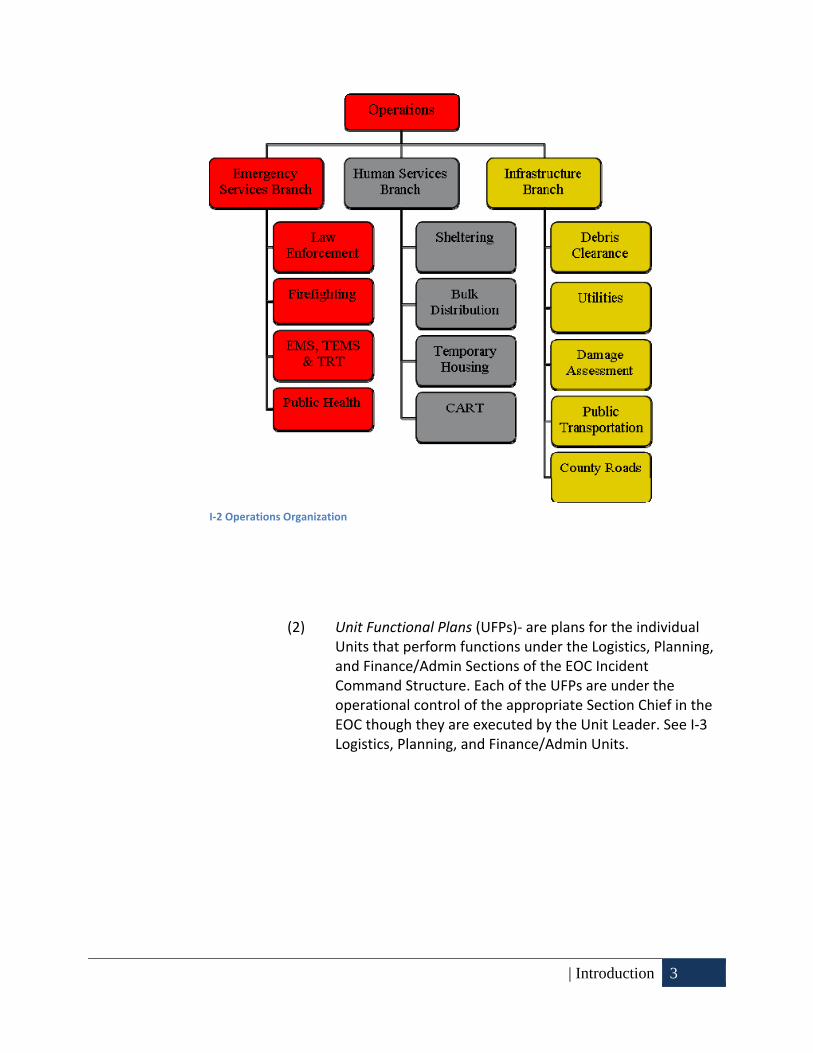
| Introduction 3
(2) Unit Functional Plans (UFPs)‐ are plans for the individual Units that perform functions under the Logistics, Planning, and Finance/Admin Sections of the EOC Incident Command Structure. Each of the UFPs are under the operational control of the appropriate Section Chief in the EOC though they are executed by the Unit Leader. See I‐3 Logistics, Planning, and Finance/Admin Units.
I‐2 Operations Organization

4 Introduction |
(3) Standard Operating Guidelines (SOGs)‐ Agency Specific Guidelines, are developed internally by each entity to facilitate accomplishment of the functions, missions, or activities outlined by the corresponding HSPs.
d. Other Annexes to this plan that are necessary for inclusion include a Mutual Aid Annex, Incident Command Forms, Southern Maryland Emergency Alert System Plan, Call Center Setup Guidelines, Important Telephone Directories, and other annexes as deemed necessary.
B. Purpose
1. General
a. This Emergency Operations Plan (EOP) provides an integrated, comprehensive, emergency management platform designed to ensure the highest level of preparedness for, response to and recovery from an emergency or disaster, whether natural or man‐made. It also provides for the mitigation of identified hazards in Charles County as well as the protection of Critical Infrastructure within Charles County’s jurisdictional boundaries.
b. The EOP establishes a framework for:
(1) Reducing loss of life, and property damage resulting from
I‐3 Logistics, Planning, and Finance/Admin Units
| Introduction 5
natural and man‐made emergencies.
(2) Preparing for prompt and efficient response and recovery activities to protect lives and property impacted by emergencies.
(3) Responding to emergencies utilizing all relevant plans and resources deemed appropriate.
(4) Recovering from emergencies by providing for the timely and orderly implementation of restoration and rehabilitation programs for persons and properties affected by emergencies.
(5) Implementing the National Incident Management System regardless of the magnitude of any given incident or disaster.
(6) Preventing attacks of terrorism through the use of appropriate interdiction activities advanced CBRNE detection, as well as information and intelligence gathering and dissemination.
(7) Preserving the health of the population, preservation of consumables and agricultural products and protection of critical infrastructure.
C. Scope
1. EOP:
a. Establishes the basic guidelines, assumptions and strategies for a comprehensive all‐hazards countywide emergency management program.
b. Prioritizes protection of life as the first priority with the second priority being the preservation and protection of property and the environment.
c. Operational structure is based on NIMS which is applicable to minor, major or catastrophic disasters.
d. Is flexible and scalable, depending on the emergency situation and needs.
e. Identifies staff roles and resource allocation, as well as decision‐making criteria. It delineates lines of authority, responsibilities and

6 Introduction |
working relations of various entities.
f. Establishes the procedures to coordinate with local, regional, state and federal emergency management agencies, organizations and programs as well as non‐governmental organization (NGOs).
g. Brings together local, state, federal and private resources in a unified and coordinated approach to manage disaster situations.
h. Addresses management and prioritization of local resources and establishes the procedures to request immediate assistance for resources, if needed. State and/or federal resources will be requested and utilized as they become available when local resources have been exhausted.
i. Provides a format for long‐range recovery and mitigation.
j. Establishes an effective program of emergency management by:
(1) Identifying the types of hazards that can impact Charles County.
(2) Determining the County’s vulnerability to various types of disasters or emergencies and identifying the most threatening so that appropriate preparedness, response, recovery, and mitigation steps can be taken.
(3) Emergency Management is comprised of four phases:
(a) Preparedness: Preparedness is a continuous cycle of planning, organizing, training, equipping, exercising, evaluation and improvement activities to ensure effective coordination and the enhancement of capabilities to prevent, protect against, respond to, recover from, and mitigate against natural disasters, acts of terrorism, and other man‐made disasters.
(b) Response: The implementation of the CEMP. Government responds to emergencies by activating its plan, incrementally increasing response as needed, giving direction and control to the emergency management effort, and looking ahead to recovery. Individuals respond by implementing their own disaster plans, and observing published emergency protective actions. Private businesses

| Introduction 7
and volunteer organizations implement their plans to secure and protect their assets, and if capable, make available resources to help the community.
(c) Recovery: Begins as soon as practical, sometimes during the response phase. The emergency management organization initiates procedures to assess needs and resources, establish priorities, reviews state and federal aid criteria and coordinates with representatives from all levels of government. Once the extent of the recovery effort is determined, the appointed recovery team members determine how best to manage the specific activities, what resources and personnel will be required and what other actions are needed to return the impacted areas to pre‐disaster condition as quickly as possible. Assessment of both short and long‐term mitigation measures takes place during this phase and the “after action” evaluation process is conducted.
(d) Mitigation: This phase involves identifying preventative and/or corrective measures and actions designed to prevent or minimize personal injury or loss of life or property damage. It includes policy issues as well as physical projects within government and the private sector. The Charles County Hazard Mitigation Plan, December 2011 serves as the guidance document for both pre‐disaster mitigation planning and post‐disaster recovery.
(4) Addressing Target Capabilities (TC) and the associated Universal Task List (UTL) as defined by Homeland Security Presidential Directive (HSPD)‐5 See Charles County Universal Task List Appendix:
(a) Common Target Capabilities;
(b) Prevention;
(c) Protection;
(d) Response; and
(e) Recovery.

8 Introduction |
D. Methodology
1. National Incident Management System (NIMS)‐
a. The National Incident Management System (NIMS) provides a systematic, proactive approach to guide departments and agencies at all levels of government, nongovernmental organizations, and the private sector to work seamlessly to prevent, protect against, respond to, recover from, and mitigate the effects of incidents, regardless of cause, size, location, or complexity, in order to reduce the loss of life and property and harm to the environment.
b. The use of NIMS by Charles County Emergency Responders ensures that there is:
(1) Comprehensive, nationwide systematic approach to incident management .
(2) Core set of doctrine, concepts, principles, terminology and organizational processes for all hazards.
(3) Essential principles for a common operating picture and interoperability of communications and information management.
(4) Standardized resource management procedures for coordination among different jurisdictions and organizations.
(5) Scalable and applicable to all incidents.
c. The benefits to Charles County include:
(1) Enhances organizational and technological interoperability and cooperation.
(2) Provides a scalable and flexible framework with universal applicability.
(3) Promotes all‐hazards preparedness.
(4) Enables a wide variety of organizations to participate effectively in emergency management/incident response.
(5) Institutionalizes professional emergency management/incident response practices.

| Introduction 9
2. Mitigation planning‐
a. Mitigation Planning will be detailed in the Charles County Hazard Mitigation Plan, December 2011.


| Hazard Identification and Risk Analysis (HIRA) 11
II. Hazard Identification and Risk Analysis (HIRA)
A. General
1. This section details the natural and man‐made hazards to which Charles County is vulnerable.
2. A key step in preventing disaster losses in Charles County is developing a comprehensive understanding of the hazards that pose risks to its communities.
3. The Charles County Hazard Mitigation Plan, December 2011, developed a detailed Hazard Identification and Risk Analysis (HIRA). This risk analysis will be summarized here in brief. For a more detailed description of hazards please see the Charles County Hazard Mitigation Plan, December 2011.
B. HIRA Methodology
1. The HIRA summary is a process or application of a methodology for evaluating risk as defined by probability and frequency of occurrence of a hazard event, exposure to people and property to the hazard, and consequences of that exposure. Different methodologies exist for assessing the risk of hazard events, ranging from qualitative to quantitative.
2. Charles County and its communities are vulnerable to a wide range of natural and technological hazards that threaten life and property. The hazards identified by the Charles County Hazard Mitigation Planning Committee (HMPC) for inclusion in this HIRA summary are those determined to be of actual potential threat to Charles County and its jurisdictions.
3. The hazards are consistent with the hazards identified by the State of Maryland and the Federal Emergency Management Agency for this part of the State and this region of the country. The hazards for this 2011 Plan update include:
a. Earthquake
b. Erosion
c. Drought
d. Flood

12 Hazard Identification and Risk Analysis (HIRA) |
e. Hurricane
f. Severe Winter Storms
g. Temperature Extremes
h. Thunderstorms and Lightening
i. Tornadoes
j. Wildfire
k. Hazardous Materials
l. Public Health Emergencies
m. Nuclear Events
4. Some of these hazards can be interrelated (for example, severe storms can produce high wind/tornado activity and can cause flooding), and thus discussion of these hazards may overlap where necessary throughout the HIRA.
5. Identified hazards have been ranked based on a Risk Factor (RF) approach. To further focus on the list of identified hazards for this Plan, Table II‐1 presents a list of all federal disaster and emergency declarations that have occurred in Charles County since 1953, according to the Federal Emergency Management Agency. This list presents the foundation for identifying what hazards pose the greatest risk within Charles County.
Presidential Disaster and Emergency Declarations in Charles County DECLARATION # DATE EVENT DETAILS
FEMA‐EM‐4038‐MD 09/05/2011 Tropical Storm Lee
FEMA‐EM‐4034‐MD 08/27/2011 Hurricane Irene
FEMA‐DR‐1910‐MD 05/06/2010 Severe Winter Storms and Snowstorms
FEMA‐DR‐1875‐MD 02/19/2010 Severe Winter Storms and Snowstorms
FEMA‐DR‐1492‐MD 09/19/2003 Hurricane Isabel
FEMA‐DR‐1409‐MD 05/01/2002 Tornado
FEMA‐DR‐1324‐MD 04/10/2000 Winter Storm
FEMA‐DR‐1303‐MD 09/24/1999 Hurricane Floyd
FEMA‐DR‐1081‐MD 01/11/1996 Blizzard
FEMA‐DR‐1016‐MD 03/16/1994 Ice Storms, Severe Storm, Winter Storm
FEMA‐DR‐0489‐MD 10/04/1975 Heavy Rains, Flooding
FEMA‐DR‐0341‐MD 06/23/1972 Tropical Storm Agnes
FEMA‐EM‐3251‐MD 09/13/2005 Hurricane Katrina Evacuation
FEMA‐EM‐3179‐MD 03/14/2003 Snowstorm
FEMA‐EM‐3100‐MD 03/16/1993 Severe Snowfall and Winter Storm II‐1 Presidential Disaster and Emergency Declarations

| Hazard Identification and Risk Analysis (HIRA) 13
6. Hazards were ranked in order to provide structure and prioritize the mitigation goals and actions discussed in the Charles County Hazard Mitigation Plan. Ranking was both quantitative and qualitative. First, the quantitative analysis considered all the Geographic Information Systems (GIS) and HAZUS (Hazards United States) data available. Then, a qualitative approach, the Risk Factor (RF) approach, was used to provide additional insights on the specific risks associated with each hazard. This process can also be a valuable cross‐check or validation of the quantitative analysis performed.
7. The RF approach combines historical data, local knowledge, and consensus opinions to produce numerical values that allow identified hazards to be ranked against one another.
8. RF values are obtained by assigning varying degrees of risk to five categories for each hazard: probability, impact, spatial extent, warning time, and duration. Each degree of risk is assigned a value ranging from 1 to 4 and a weighing factor for each category. To calculate the RF value for a given hazard, the assigned risk value for each category is multiplied by the weighting factor. The sum of all five categories equals the final RF value, as demonstrated in the example equation:
RF Value = [(Probability x .30) + (Impact x .30) + (Spatial Extent x .20) + (Warning Time x .10) + (Duration x .10)]
II‐2: RF Value

14 Hazard Identification and Risk Analysis (HIRA) |
RISK FACTOR CRITERIA
RISK ASSESSMENT CATEGORY LEVEL DEGREE OF RISK LEVEL INDEX WEIGHT
PROBABILITY What is the likelihood of a hazard event occurring in a given year?
UNLIKELY LESS THAN 1% ANNUAL PROBABILITY 1
30% POSSIBLE BETWEEN 1 & 10% ANNUAL PROBABILITY 2
LIKELY BETWEEN 10 & 100% ANNUAL PROBABILITY
3
HIGHLY LIKELY 100% ANNUAL PROBABILTY 4
IMPACT In terms of injuries, damage, or death, would you anticipate impacts to be minor, limited, critical, or catastrophic when a significant hazard event occurs?
MINOR
VERY FEW INJURIES, IF ANY. ONLY MINOR PROPERTY DAMAGE & MINIMAL DISRUPTION OF QUALITY OF LIFE. TEMPORARY SHUTDOWN OF CRITICAL FACILITIES.
1
30%
LIMITED
MINOR INJURIES ONLY. MORE THAN 10% OF PROPERTY IN AFFECTED AREA DAMAGED OR DESTROYED. COMPLETE SHUTDOWN OF CRITICAL FACILITIES FOR MORE THAN ONE DAY.
2
CRITICAL
MULTIPLE DEATHS/INJURIES POSSIBLE. MORE THAN 25% OF PROPERTY IN AFFECTED AREA DAMAGED OR DESTROYED. COMPLETE SHUTDOWN OF CRITICAL FACILITIES FOR MORE THAN ONE WEEK.
3
CATASTROPHIC
HIGH NUMBER OF DEATHS/INJURIES POSSIBLE. MORE THAN 50% OF PROPERTY IN AFFECTED AREA DAMAGED OR DESTROYED. COMPLETE SHUTDOWN OF CRITICAL FACILITIES FOR 30 DAYS OR MORE.
4
SPATIAL EXTENT How large of an area could be impacted by a hazard event? Are impacts localized or regional?
NEGLIGIBLE LESS THAN 1% OF AREA AFFECTED 1
20%
SMALL BETWEEN 1 & 10% OF AREA AFFECTED 2
MODERATE BETWEEN 10 & 50% OF AREA AFFECTED 3
LARGE BETWEEN 50 & 100% OF AREA AFFECTED 4
WARNING TIME Is there usually some lead time associated with the hazard event? Have warning measures been implemented?
MORE THAN 24 HRS
SELF DEFINED 1
10%
12 TO 24 HRS SELF DEFINED 2
6 TO 12 HRS SELF DEFINED 3
LESS THAN 6 HRS
SELF DEFINED 4
DURATION How long does the hazard event usually last?
LESS THAN 6 HRS
SELF DEFINED 1
10%
LESS THAN 24 HRS
SELF DEFINED 2
LESS THAN 1 WEEK
SELF DEFINED 3
MORE THAN 1 WEEK
SELF DEFINED 4
II‐3: Risk Factor Criteria

| Hazard Identification and Risk Analysis (HIRA) 15
9. According to the default weighting scheme applied, the highest possible RF value is 4.0. The methodology illustrated above lists categories that are used to calculate the variables for the RF value.
C. HIRA Risk Factor Ranking Results
Risk Factor Ranking Results for Charles County Hazards. Natural Hazards Probability Impact
Spatial Extent
Warning Time Duration
RF Factor
Thunderstorms and Lightning 4 1.2 1 0.3 3 0.6 4 0.4 1 0.1 2.6
Tornado 2 0.6 3 0.9 3 0.6 4 0.4 1 0.1 2.6
Hurricane 2 0.6 3 0.9 4 0.8 1 0.1 2 0.2 2.6
Severe Winter Storms 3 0.9 1 0.3 4 0.8 1 0.1 3 0.3 2.4
Temperature Extremes 4 1.2 2 0.6 4 0.8 1 0.1 3 0.3 3.0
Flood 3 0.9 2 0.6 2 0.4 1 0.1 2 0.2 2.2
Drought 1 0.3 1 0.3 4 0.8 1 0.1 4 0.4 1.9
Wildfire 1 0.3 1 0.3 1 0.2 4 0.4 2 0.2 1.4
Earthquake 1 0.3 1 0.3 3 0.6 4 0.4 1 0.1 1.7
Erosion 3 0.9 1 0.3 1 0.2 1 0.1 3 0.3 1.8 Technological
Hazards Probability Impact Spatial Extent
Warning Time Duration
RF Factor
Nuclear Events 1 0.3 2 0.6 1 0.2 2 0.2 4 0.4 1.7
Hazardous Materials 4 1.2 1 0.3 1 0.2 4 0.4 2 0.2 2.3
Public Health Emergency 1 0.3 2 0.6 2 0.4 4 0.4 4 0.4 2.1 II‐4: Risk Factor Ranking Results
1. Based on the RF analysis, the natural hazard with the highest risk potential is “Temperature Extremes”, which has a value of 3.0. This is primarily due to the probability of the hazard occurring and the spatial extent of the potential widespread damage within the affected areas of the County. “Thunderstorms and Lightning, ” “Tornado,” and “Hurricane” were qualitatively calculated as second in risk potential, each receiving a value of 2.6. The technological or human‐made hazard with the highest risk potential was found to be “Hazardous Materials”, with a value of 2.3. This is primarily due to a lack of warning time and a high level of probability.
2. The conclusions drawn from the qualitative and quantitative assessments

16 Hazard Identification and Risk Analysis (HIRA) |
were fitted into three categories for a final summary of hazard risk for Charles County based on High, Moderate or Low risk designations.
Summary of Hazard Risk for Charles County
HIGH RISK (3.0 or higher) Temperature Extremes
MODERATE RISK (2.0 – 2.9) Thunderstorms and Lightning, Tornado, Hurricane, Severe Winter Storm, Flood, Hazardous Materials, and Public Health Emergency
LOW RISK (0.1 – 1.9) Drought, Wildfire, Earthquake, Erosion, and NuclearEvents
II‐5: Summary of Hazard Risk

| Geographic Information 17
III. Geographic Information
A. Introduction
1. A complete understanding of the community’s geography, demographics, and land use trends is essential to be able to minimize the possible loss of life, human suffering, and damage to public and private property associated with major natural or man‐made incidents.
2. The hazards analysis involves not only knowledge of the kinds of hazards to which Charles County is subjected, but also specific estimates of people and property at risk from a particular hazard. When this measure of vulnerability, reflecting a worst‐case situation, is combined with available hazard information, the community can estimate the frequency and extent of damage and the areas and persons affected. This combination of factors is the key to determining if present capabilities are adequate for mitigating, preparing for, and responding to an emergency, and if found inadequate, identifying procedures needed to upgrade these capabilities.
B. Geographic Characteristics
1. Charles County is located in Southern Maryland approximately 18 miles south of Washington, D.C. It is bordered by Prince George’s County to the north; the Potomac River to the west and south; with the Wicomico River, St. Mary’s County, and a short segment of the Patuxent River to the east. Charles County contains three incorporated towns, Indian Head, La Plata, and Port Tobacco.
2. Located in the Atlantic Coastal Plain, Charles County is relatively low‐lying area. Elevations range from 10 feet above sea level near the Potomac River to approximately 230 feet near Waldorf. Large portions of the County are exceedingly flat, with a gentle slope toward the Chesapeake Bay or toward local drainage features. Broad plateau formations with sides dissected by drainage features are common throughout most of the County. This dissection of the County shows the easily eroded clays, sands, and gravels that underlie it. In some areas, dissection is incomplete, and flat areas several miles across have not yet been reached by headward cutting streams. Stream valleys affect local topography throughout the County.
3. Stream terraces are located in several locations along the County’s 183 miles of river shoreline. These elevated terraces are found in the Marshall Hall, Stump Neck, Moss Point, Maryland Point, and Clifton areas. Adjacent to the Potomac and Patuxent Rivers are low‐lying flats

18 Geographic Information |
not more than 10 to 25 feet above sea level. These areas vary in width from a few feet where the river current of the Potomac River washes strongly against the shoreline (such as is found at several locations in western Charles County near Indian Head and Potomac Heights) to more than a mile in the southern part of the County, such as Allen’s Fresh. The interior of the County, along US 301 from Faulkner to the Prince George’s County line, is predominately flat. Outward from this plateau, dissection becomes more pronounced, and the land Is gently rolling and hilly to sleeply sloping.
C. Existing Land Use Characteristics
1. Since 1950, population, housing and commerce have expanded greatly due, in part, to the proximity to the Washington metropolitan complex. The County is now a mixture of the suburban development, primarily in the northwest section of the County, interspersed with older rural and semi‐rural development patterns found elsewhere in the County.
2. Charles County comprises 460 square miles of land area. As of 2002, approximately 17 percent or 51,000 acres of this land area was developed, an increase of approximately 9,200 or 22 percent, since 1990. There has been a comparable decline of approximately 9,200 acres of resource lands during this period which now comprise approximately 244,000 acres or 82 percent of the County, down from 86 percent in 1990. Recent development within Charles County has occurred in its north‐west quadrant; along the MD 228 and MD 229 corridors; east of this corridor in the St. Charles area; in Hughesville area; and in the Town of La Plata. In 2002, approximately 17 percent of the County’s land area was “developed.”
3. The following list summarizes the existing land use for Charles County in 2002:
Low Density Residential 33,156
Medium/High Density Residential 6,933
Commercial/Industrial/Transportation 4,616
Institutional/Open 3,695
Other 2,258
Agriculture 57,514
Forest 178,472
Extractive/Barren/Bare 860
Wetland 6,900 Source: 2006 Charles County Comprehensive Plan
III‐1: Summary of Land Use

| Geographic Information 19
D. Surface Water System
1. Although Charles County is bordered by both the Patuxent and Potomac River systems, their use as surface water supply sources is constrained because of their salinity concentrations. The County also has a large number of smaller rivers and streams which are incapable of any large‐scale water supply. There are presently three lakes in Charles County (Wheatley, Jameson, and Trinity) with a suitable surface water area of about 12 square miles required for use as reservoirs. However, due to the locations of the lakes and the infrastructure improvements necessary to serve the development district, these water sources are not a feasible source of public water supply.
2. With the exception of Swanson and Indian Creeks, which flow into the Patuxent River system, all drainage flows into the Potomac River or its tributaries. Major water bodies within the County include the Wicomico River, Zekiah Swamp, Gilbert Swamp, Port Tobacco Creek, Port Tobacco River, Nanjemoy Creek, Mattawoman Creek and the Pomonkey Creek. Eastern portions of the County are drained by Zekiah Swamp Run and the Gilbert Swamp Run, along with their tributaries. Northern portions of the County are drained by the Mattawoman and Pomonkey Creeks. Central and northwestern portions of the County are drained by the Port Tobacco River, Nanjemoy Creek, Wards Run and Mill Run.
3. The major groundwater resources of Charles County are the aquifers of the Patuxent, Patapsco, Magothy, and Aquia Formations; and deposits of Pliocene and Pleistocene Age. The major water supply sources are the Magothy and Patapsco aquifers. These aquifers are found at depths ranging from 300 to 1,000 feet below the ground elevation. Groundwater provides the vast majority of the drinking water in Charles County. In a few places, it is available from springs; but in most locations, water is drawn from drilled or dug wells tapping into underlying water‐bearing aquifers. In most cases, the aquifers most suitable for potable water supply occur 300 to 800 feet below the surface.
E. Transportation
1. Charles County is served by approximately 1,100 miles of highways, of which the County maintains approximately 700 miles. Charles County has commuter and regular bus services available through the Maryland Transit Administration, Washington Metropolitan Area Transit Authority and VanGO through the Department of Community Services. There is a small privately owned airport located in Pomonkey but only provides charter services.

20 Geographic Information |
2. Traffic on all major highways grew between 1994 and 2003 consistent with regional and statewide trends. Growth was particularly apparent on MD 5 and MD 210. Total Annual Average Daily Traffic (AADT) on US 301 just north of the Charles County/Prince George’s County line exceeded 81,000 vehicles per day in 2003, reflecting the importance of this route as a major connector to Prince George’s County and as a commuter route to work locations in Washington DC, Northern Virginia and points north of the County. Charles County continues to be a net exporter of commuters. Of the 61,698 commuters who resided in Charles County in 2000, 36,898 (60 percent) commuted to work outside of the county and 24,800 (40 percent) commuted within the county. Approximately 11,420 workers commuted into Charles County. The greatest number of commuters leaving Charles County are destined for job locations in Prince George’s County (13,834 commuters or 38 percent). An additional 29 percent commute to Washington DC. Of the 11,420 commuters who travel into Charles County from other locations, the largest percentage (32 percent) originate from Prince George’s County. An additional 29 percent originate from St. Mary’s County.

| Geographic Information 21
F. Farms
Agricultural Profile 1992 1997 2002
Farm Numbers
Number of Farms 496 451
418
Average Size (acres) 120 126
125
Land in Farms 59,389 56,648
52,056
Livestock Inventory
Cattle 3,064 3,068
2,797
Hogs 4,407 1,575
309
Sheep 389 500
368
Demographic Data
Average Age of Operator 54 54
57
Percent Female Operators 7 10
19
Source: Census of Agriculture, NASS
III‐2: Agricultural Profile

22 Geographic Information |
G. Special Needs Information
1. The Charles County Emergency Services in coordination with the Charles County Department of Community Services, Charles County Health Department and Charles County Department of Social Services implemented a special needs database in April 2009. The Charles County database was created to identify individuals within the County that require additional resources during an emergency or disaster. This database will interface with the 911 system to flag the individual’s location, enabling our Dispatchers to send additional personnel or apparatus during the initial dispatch. The Department of Emergency Services will also use the database as a planning tool for evacuation timelines. The Health Department will use the database to coordinate shelter arrangements.
H. Land Cover
III‐3: Land Cover Map

| Demographic Information- January 2012 23
IV. Demographic Information January 2012
A. Introduction
1. The population of Charles County is mainly situated in the Waldorf and La Plata areas. These areas are within the developmental district of the County. A total of 652 residential lots were approved in 2008. Eighty‐two percent (532) were located within the Developmental District. There were 684,444 square feet of new commercial/industrial space. Sixty percent were located within the Developmental District.
2. The overall distribution of population by election district can be seen on the following table. The age distribution chart that follows shows that by far the majority of the population is less than 45 years old.
3. The population of Charles County in 2010 was a little over 146,555; 75,769 (51.5%) females and 70,786 (48.3%) males. The median age was 34.8 years. Twenty‐six percent of the population was under 18 years and nine percent was 65 years and older.
0 20 40 60 80 100
Under 5 Yrs.
5‐24 Yrs.
25‐44 Yrs.
45‐64 Yrs.
65 and Over
7
29
30
25
8
Percent of Population
Age
Category
The Age Distribution of Charles County, MD
IV‐1: Age Category Percent of Population‐ Source American Community Survey 2007

24 Demographic Information- January 2012 |
B. Charles County population density & distribution
Planning District Population Projections
Election District 2000 2005 2010 2015 2020
La Plata 12,053 14,526 15,858 18,121 20,384
Hill Top 1,912 2,047 2,119 2,288 2,456
Nanjemoy 3,169 3,323 3,457 3,478 3,550
Allens Fresh 4,641 4,929 5,184 5,311 5,538
Thompkinsville 3,682 4,046 4,334 4,503 4,971
Waldorf 62,538 72,509 75,924 83,430 90,935
Pomonkey 11,857 13,333 15,483 16,892 18,001
Bryantown 12,616 13,646 14,372 15,991 17,609
Hughesville 4,844 5,879 6,771 7,856 8,940
Marbury 3,234 3,764 4,049 4,423 4,797
County Totals 122,546 140,007 149,561 164,308 179,201
Source: Charles County Department of Planning and Growth Management‐ Years 2000 & 2010 based upon Census data.
IV‐2 Planning District Population Projections

| Demographic Information- January 2012 25
C. Charles County population distribution by age/gender
2005 Population 136,600 2010 Population 144,940
Males 66,410 Males 70,150
Females 70,190 Females 74,790
Age of Population Age of Population
65+ years 11,150 65+ years 13,550
45 ‐ 64 years 33,740 45 ‐ 64 years 39,510
20 ‐ 44 years 48,990 20 ‐ 44 years 46,820
5 – 19 years 32,570 5 – 19 years 34,340
0 – 4 years 10,150 0 – 4 years 10,720
Source: Maryland Department of Planning, Planning Data as of February 2009 IV‐3 Population Distribution

26 Demographic Information- January 2012 |
D. Non‐English Speaking Population
IV‐4 Non English Speaking Population
E. Demographic description of Charles County’s population
Characteristic Estimate Percent
Total Population 140,444
Male 66,828 47.6%
Female 73,616 52.4%
Median age (years) 34.8 N/A
Under 5 years 9,876 7.0%
5 years to 24 years 41,576 29.6%
25 years to 44 years 42,245 30.1%
45 years to 64 years 35,325 25.2%
65 years and older 11,422 8.1%
White 77,931 55.5%
Black or African American 51,585 36.7%
American Indian and Alaska Native 1,018 0.7%
Asian 3,252 2.3%
Native Hawaiian and Other Pacific Islander 55 0.0%
Some other race 1,165 0.8%
Charles County Non‐English speaking population
Charles County, Maryland Estimate
Language other than English 5,731
Speak English less than “very well” 1,928
Spanish 2,329
Speak English less than “very well” 768
Other Indo‐European languages 1,837
Speak English less than “very well” 539
Asian and Pacific Island languages 1,224
Speak English less than “very well” 550
Source: American Community Survey 2007

| Demographic Information- January 2012 27
Two or more races 5,438 3.9%
Social Characteristics
Population 25 years and older 88,992 N/A
High school graduate or higher 79,254 89.1%
Bachelor’s degree or higher 23,314 26.2%
Civilian veterans 17,680 N/A
Disability status (population 5 years and over) 127,412 N/A
Foreign Born 6,975 5.0%
Male, Now married, except separated (population 15 years and over) 27,771 N/A
Female, Now married, except separated (population 15 years and over) 28,605 N/A
Economic Characteristics
In labor force (population 16 years and older) 80,486 N/A
Mean travel time to work in minutes (workers 16 years and over) 38.6 N/A
Median household income (in 2007 inflation‐adjusted dollars) 83,412 N/A
Median family income (in 2007 inflation‐adjusted dollars) 92,389 N/A
Per capita income (in 2007 inflation‐adjusted dollars) 33,572 N/A
Housing Characteristics
Average household size 2.85 N/A
Average family size 3.29 N/A
Total housing units 52,630 N/A
Occupied housing units 49,001 93.1%
Owner‐occupied housing units 39,394 74.9%
Renter‐occupied housing units 9,607 18.3%
Vacant housing units 3,629 6.9%
Median value (dollars) 371,100 N/A
Housing units with a mortgage 32,654 N/A
Housing units not mortgaged 6,740 N/A
Source: U.S. Census Bureau, 2007 American IV‐5 Demographic Description
1. In 2007, there were 49,001 households in Charles County, Maryland. The average household size was 2.85 people. Families made up 75 percent of the households. This figure includes both married‐couple families (53 percent) and other families (25 percent). Non‐family households made up 25 percent of all households. Most of the non‐family households were people living alone, but some were comprised of people living in households in which no one was related to the householder.

28 Demographic Information- January 2012 |
F. Geographic mobility
1. In 2007, 91 percent of the people living at their current residence were living there a year earlier; 2 percent had moved during the past year from another residence in the same county, 4 percent from another county in the same state, and 2 percent from another state.
0 20 40 60 80 100
Other nonfamily households
People living alone
Married‐Couple
Family Households
25
21
53
75
Percent of Households
Type of Household
The Types of Households in Charles County, Maryland in 2007
IV‐6 Types of Households

| Demographic Information- January 2012 29
G. Education
1. In 2007, 89 percent of people 25 years and over had at least graduated from high school and 26 percent had a bachelor’s degree or higher. The total school enrollment in Charles County was 39,252 in 2007. Preprimary school enrollment was 4,210, the elementary school enrollment was 16,176, the high school enrollment was 9,455 and the college or graduate school enrollment was 9,411.
0 20 40 60 80 100
Different State
Different county, same state
Different residence, same county
Same residence
2
4
2
91
Percentage of Residence
Residence 1 year ago
Geographic Mobility of Residents of Charles County, Maryland in 2007
Source: American Community Survey, 2007
IV‐8: Geographic Mobility

30 Demographic Information- January 2012 |
0 20 40 60 80 100
Less than high school diploma
High school diploma or equivalency
Some college, no degree
Associate degree
Bachelor's degree
Graduate or professional degree
11
30
24
8
17
10
Percent of people 25 years and over
Highest Level
The Educational Attainment of People in Charles County, Maryland in 2007
Source: American Community Survey, 2007IV‐9 Educational Attainment

| Economic Profile – Jan 2012 31
V. Economic Profile – Jan 2012
A. Economic Characteristics
CHARACTERISTIC ESTIMATE
EMPLOYMENT STATUS
Population 16 years and older 107,046
In labor force 80,486
Civilian labor force 78,112
Employed 74,715
Unemployed 3,397
Armed Forces 2,374
Not in labor force 26,560
Civilian labor force 78,112
Unemployed 4.3%
Females 16 years and over 56,692
In labor force 40,196
Civilian labor force 39,912
Employed 38,662
Own Children under 6 years 11,479
All parents in family in labor force 8,751
Own Children 6 to 17 years 24,628
All parents in family in labor force 19,717
COMMUNTING TO WORK
Workers 16 years and over 75,263
Car, truck, or van – drove alone 59,124
Car, truck, or van – carpooled 8,226
Public transportation (excluding taxicab) 4,994
Walked 419
Other means 643
Worked at home 1,857
Mean travel time work (minutes) 38.6
OCCUPATION
Employed civilian population 16 years and over 74,715
Management, professional, and related occupations 29,221
Service occupations 11,782
Sales and office occupations 19,271
Farming, fishing, and forestry occupations 233
Construction, extraction, maintenance and repair occupations 7,395
Production, transportation, and material moving occupations 6,813
INDUSTRY
Employed civilian population 16 years and over 74,715
Agriculture, forestry, fishing and hunting, and mining 766

32 Economic Profile – Jan 2012 |
Construction 5,460
Manufacturing 2,701
Wholesale trade 1,270
Retail trade 8,831
Transportation and warehousing, and utilities 4,692
Information 2,388
Finance and insurance, and real estate and rental and leasing 4,663
Professional, scientific, and management, and administrative and waste management services
8,632
Educational services, and health care, and social assistance 13,118
Arts, entertainment, and recreation, and accommodation, and food services 4,361
Other services, except public administration 2,937
Public administration 14,896
CLASS OF WORKER
Employed civilian population 16 years and over 74,715
Private wage and salary workers 48,711
Government workers 23,371
Self‐employed workers in own not incorporated business 2,633
Unpaid family workers 0
INCOME AND BENEFITS (IN 2004 INFLATION‐ADJUSTED DOLLARS)
Total households 49,001
Less than $10,000 1,307
$10,000 to $14,999 1,435
$15,000 to $24,999 2,252
$25,000 to $34,999 3,129
$35,000 to $49,999 4,821
$50,000 to $74,999 8,390
$75,000 to $99,999 8,295
$100,000 to $149,999 11,991
$150,000 to $199,999 4,658
$200,000 or more 2,723
Median household income (dollars) 83,412
Mean household income (dollars) 92,993
With earnings 43,877
Mean earnings (dollars) 89,823
With Social Security 10,668
Mean Social Security income (dollars) 12,489
With retirement income 11,263
Mean retirement income (dollars) 26,759
With supplemental security income 1,229
Mean supplemental security income (dollars) 6,764
With cash public assistance income 945
With food stamps benefits in the past 12 months 2,632

| Economic Profile – Jan 2012 33
Families 36,855
Less than $10,000 505
$10,000 to $14,999 240
$15,000 to $24,999 1,378
$25,000 to $34,999 2,227
$35,000 to $49,999 3,176
$50,000 to $74,999 6,543
$75,000 to $99,999 5,897
$100,000 to $149,999 10,270
$150,000 to $199,999 3,963
$200,000 or more 2,656
Median family income (dollars) 92,389
Mean family income (dollars) 102,026
Per capita income (dollars) 33,572
Non‐family households 12,146
Median non‐family income (dollars) 52,311
Mean non‐family income (dollars) 59,288
Median earnings: 42,477
Male full‐time, year‐round workers (dollars) 60,825
Female fulltime, year‐round workers (dollars) 47,159
PERCENTAGE OF FAMILIES AND PEOPLE WHOSE INCOME IN THE PAST 12 MONTHS IS BELOW THE POVERTY LEVEL
All families 2.5%
With related children under 18 years 3.6%
With related children under 5 years only 9.6%
Married couple families 0.5%
With related children under 18 years 0.4%
With related children under 5 years only 0.0%
Families with female householder, no husband present 5.7%
With related children under 18 years 5.9%
With related children under 5 years only 0.0%
All people 4.7%
Under 18 years 5.4%
Related children under 18 years 5.0%
Related children under 5 years 10.0%
Related children 5 to 17 years 3.1%
18 years and over 4.5%
18 to 64 years 4.2%
65 years and over 6.5%
People in families 2.9%
Unrelated individuals 15 years and over 16.5%Source: American Community Survey, 2007
V‐1 Economic Characteristics

34 Economic Profile – Jan 2012 |
B. Industries
1. In 2007, for the employed population 16 years and older, the leading industry in Charles County, Maryland was public administration totaling 20 percent, closely followed by educational, health and social services at 18 percent. As demonstrated by the chart below, agriculture made up for 1 percent.
Source: American Community Survey, 2007
NOTE: The Professional and business services category includes the following industries: Professional, scientific, management, administrative, and waste management services. The Leisure and hospitality category includes the following industries: Arts, entertainment, recreation, accommodation, and food services.
C. Occupational characteristics
1. Among the most common occupations were: Management, professional, and related occupations ‐ 39 percent; Sales and office occupations ‐ 26 percent; Service occupations – 16 percent; Construction, extraction, maintenance and repair occupations – 10 percent, and Production, transportation and material moving occupations – 9 percent. Sixty‐five percent of the people were private wage and salary workers; 31 percent
0 20 40 60 80 100
Public Administration
Other services (except public administration)
Leisure and hospitality
Educational, health and social services
Professional and business service
Finance, insurance, real estate, and rental and leasing
Information
Transportation and warehousing, and utilities
Retail trade
Wholesale trade
Manufacturing
Construction
Agriculture, forestry, fishing and hunting and mining
20
4
6
18
12
6
3
6
12
2
4
7
1
Percent of employed population 16 years and over
Type of Industry
Employment by Industry in Charles County, Maryland in 2007
V‐2 Employment by Industry

| Economic Profile – Jan 2012 35
were federal, state or local government workers; and 4 percent were self‐employed.
D. Commuting
1. Seventy‐nine percent of the Charles County, Maryland citizens drove to work alone in 2007, 11 percent carpooled, 7 percent took public transportation, and 1 percent used other means. The remaining 2 percent worked at home. Among those who commuted to work, it took them on average 38.6 minutes to get to work.
E. Poverty rates in Charles County
1. In 2007, on average 5 percent of the population were in poverty. The chart below demonstrates that 5% of related children under 18 were below the poverty level, compared with 7 percent of people 65 years old and over. Three percent of all families and 6 percent of families with a female householder and no husband present had incomes below the poverty level.
Source: American Community Survey, 2007
0 20 40 60 80 100
Female householder families
All families
Related children under 18
People age 65 and over
6
3
5
7
Percent below poverty level
Families or people
Poverty Rates in Charles County, Maryland in 2007
V‐3 Poverty Rates
36 Economic Profile – Jan 2012 |
Source: American Community Survey, 2007
F. Housing Characteristics
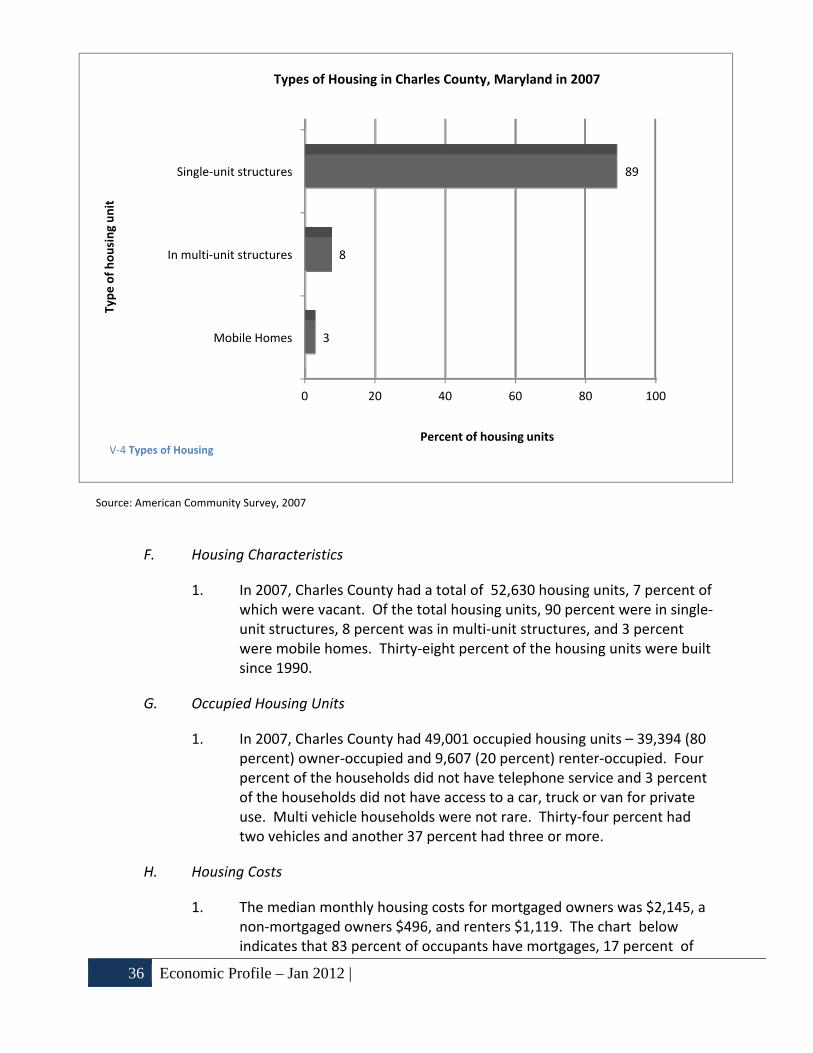
1. In 2007, Charles County had a total of 52,630 housing units, 7 percent of which were vacant. Of the total housing units, 90 percent were in single‐unit structures, 8 percent was in multi‐unit structures, and 3 percent were mobile homes. Thirty‐eight percent of the housing units were built since 1990.
G. Occupied Housing Units
1. In 2007, Charles County had 49,001 occupied housing units – 39,394 (80 percent) owner‐occupied and 9,607 (20 percent) renter‐occupied. Four percent of the households did not have telephone service and 3 percent of the households did not have access to a car, truck or van for private use. Multi vehicle households were not rare. Thirty‐four percent had two vehicles and another 37 percent had three or more.
H. Housing Costs
1. The median monthly housing costs for mortgaged owners was $2,145, a non‐mortgaged owners $496, and renters $1,119. The chart below indicates that 83 percent of occupants have mortgages, 17 percent of
0 20 40 60 80 100
Mobile Homes
In multi‐unit structures
Single‐unit structures
3
8
89
Percent of housing units
Type of housing unit
Types of Housing in Charles County, Maryland in 2007
V‐4 Types of Housing

| Economic Profile – Jan 2012 37
occupants do not have mortgages, and 28 percent of the renters spent more than 35 percent of their household income on housing.
Source: American Community Survey, 2007
0 20 40 60 80 100
Renters
Owners without mortgage
Owners with mortgage
28
3
27
Percent paying 35 percent or more of income for housing
Type of Occupan
t
Occupants with a Housing Cost Burden in Charles County, Maryland in 2007
V‐5 Occupants with a Housing Cost Burden

38 Economic Profile – Jan 2012 |
I. Potential economic impacts of hazards
1. Employment and per capita income
a. The effects of the hazards that will have an impact on employment levels and per capita income in Charles County are dependent upon the type and magnitude of the disaster. The effects of a direct hurricane strike and associated phenomena can be expected to have a major temporary negative impact on employment and income in Charles County. All of the County’s industries will be disrupted in the aftermath of a storm, but large‐scale economic disruptions will probably be short‐lived. According to research, there will be a short‐term spike in unemployment claims. This will be tempered when employment increases as workers are added in emergency services, cleanup, and construction.
b. Brush fires, large terrorism events and critical infrastructure/transportation disruptions may also have a widespread, temporary negative effect on employment and wages. The effects of most other hazards on employment levels can be expected to have more of a localized impact. For example: a hazardous materials spill will only have an effect on employment at the actual site where the event occurs; a tree disease outbreak will only affect timber workers. Other hazards such as a critical infrastructure disruption may have a widespread but temporary effect.
2. Average property values
a. Hazards with widespread effects, such as hurricanes and its associated storm surge, will cause a short‐term County‐wide devaluation in property values. A portion of the homes in the County will be destroyed or damaged. However, redevelopment may spur a long‐term escalation in property values. As with the impacts on employment, most other hazards will probably only affect a small number of homeowners in a localized area.

| Resource Typing 39
VI. Resource Typing
A. Introduction
1. Resource typing is categorizing, by capability, the resources requested, deployed, and used in incidents. Measurable standards identifying resource capabilities and performance levels serve as the basis for categories. Resource users at all levels use these standards to identify and inventory resources. Resource kinds may be divided into subcategories to define more precisely the capabilities needed to meet specific requirements.
2. Charles County uses the FEMA Typed Resource Definitions to categorize all resources.
3. The Emergency Management Division keeps up to date Typed Resource Lists for Charles County on file in the EOC and on WebEOC for state reference and request.
a. The Typed Resource List is available at request to the Emergency Management Specialist Desk.


| Concept of Operations 41
VII. Concept of Operations
A. Assumptions
1. An emergency or disaster may occur with little or no warning, and escalate rapidly.
2. Charles County is capable of responding to most emergencies or disasters.
3. Charles County will utilize resources obtained by pre‐arranged agreements with mutual aid jurisdictions and the local private sector prior to seeking assistance from the state.
4. In the event an emergency exceeds local capability, the county will request assistance from state government.
5. The state and federal government will provide additional resources when response and recovery demands exceed local capability during a presidentially declared emergency or disaster. In some instances, federal agencies may provide direct assistance without a Presidential declaration.
B. National Incident Management System
1. Charles County adopted the NIMS in October 2004 to ensure consistency with Homeland Security Presidential Directive (HSPD)‐ 5, which Directed the Secretary of Homeland Security to develop and administer the NIMS. According to HSPD‐5:
“This system will provide a consistent nationwide approach for federal, state, and local governments to work effectively and efficiently together to prepare for, respond to, and recover from domestic incidents, regardless of cause, size, or complexity. To provide for interoperability and compatibility among federal, state, and local capabilities, the NIMS will include a core set of concepts, principles, terminology, and technologies covering the incident command system, multi‐agency coordination systems; unified command; training; identification and management of resources (including systems for classifying types of resources); qualifications and certification; and the collection, tracking, and reporting of incident information and incident resources.”

42 Concept of Operations |
C. NIMS Components
The NIMS integrates Charles County responders into a consistent, nationwide approach to incident management that is applicable at all jurisdictional levels and across functional disciplines in an all‐hazards context. There are six major components of NIMS that Charles County will utilize to manage incidents:
1. Command and Management
NIMS standard incident command structures are based on three key organizational systems:
a. Incident Command System (ICS)‐ ICS defines the operating characteristics, interactive management components, and structure of incident management and emergency response organizations engages throughout the life cycle of an incident.
b. Multi‐agency Coordination Systems‐ Define the operating characteristics, interactive management components, and organizational structure of supporting incident management entities engaged at the federal, state, local, and regional levels through mutual‐aid agreements and other assistance arrangements.
c. Public Information Systems‐ These refer to processes, procedures, and systems for communicating timely and accurate information to the public during crisis or emergency situations.
2. Preparedness
Effective incident management begins with a host of preparedness activities conducted on a “steady‐state” basis, well in advance of any potential incident. Preparedness involves an integrated combination of planning, training, exercises, personnel qualification and certification standards, equipment acquisition and certification standards, and publication management processes and activities.
a. Planning – Plans describe how personnel, equipment, and other resources are used to support incident management and emergency response activities. Plans provide mechanisms and systems for setting priorities, integrating multiple entities and functions, and ensuring that communications and other systems are available and integrated in support of a full spectrum of incident management requirements.

| Concept of Operations 43
b. Training – Training includes standard courses on multi‐agency incident command and management, organizational structure, and operational procedures; discipline‐specific and agency‐specific incident management courses; and courses on the integration and use of supporting technologies.
c. Exercises – Incident management organizations and personnel must participate in realistic exercises – including multidisciplinary, multi‐jurisdictional, and multi‐sector interaction – to improve integration and interoperability and optimize resource utilization during incident operations.
d. Qualification and Certification – Qualification and certification activities are undertaken to identify and publish national‐level standards and measure performance against these standards to ensure that incident management and emergency responder personnel are appropriately qualified and officially certified to perform NIMS‐related functions.
e. Equipment Acquisition and Certification – Incident management organizations and emergency responders at all levels rely on various types of equipment to perform mission essential tasks. A critical component of operational preparedness is the acquisition of equipment that will perform to certain standards, including the capability to be interoperable with similar equipment used by other jurisdictions.
f. Publications Management – Publications management refers to forms and forms standardization, developing publication materials, administering publications – including establishing naming and numbering conventions, managing the publication and promulgation of documents, and exercising control over sensitive documents – and revising publications when necessary.
3. Resource Management
The NIMS defines standardized mechanisms and establishes requirements for processes to describe, inventory, mobilize, dispatch, track, and recover resources over the life cycle of an incident.
4. Communications and Information Management.
The NIMS identifies the requirement for a standardized framework for communications, information management (collection, analysis, and

44 Concept of Operations |
dissemination), and information‐sharing at all levels of incident management. These elements are briefly described as follows:
a. Incident Management Communications – Incident management organizations must ensure that effective, interoperable communications processes, procedures, and systems exist to support a wide variety of incident management activities across agencies and jurisdictions.
b. Information Management – Information management processes, procedures, and systems help ensure that information, including communications and data, flows efficiently through a commonly accepted architecture supporting numerous agencies and jurisdictions responsible for managing or directing domestic incidents, those impacted by the incident, and those contributing resources to the incident management effort. Effective information management enhances incident management and response and helps insure that crisis decision‐making is better informed.
5. Supporting Technologies
Technology and technological systems provide supporting capabilities essential to implementing and continuously refining the NIMS. These include voice and data communications systems, information management systems (i.e., record keeping and resource tracking), and data display systems. Also included are specialized technologies that facilitate ongoing operations and incident management activities in situations that call for unique technology‐based capabilities.
6. Ongoing Management and Maintenance
This component establishes an activity to provide strategic direction for and oversight of the NIMS, supporting both routine review and the continuous refinement of the system and its components over the long term.
D. NIMS Concepts and Principles.
1. Most Incidents Are Managed Locally
The initial response to most incidents is typically handled by local “9‐1‐1” dispatch centers, emergency responders within a single jurisdiction, and direct supporters of emergency responders. Most responses do not need to go further. In other instances, incidents that begin with a single response discipline within a single jurisdiction may rapidly expand to multidiscipline, multi‐jurisdictional incidents requiring significant

| Concept of Operations 45
additional resources and operational support. Whether for incidents in which additional resources are required or are provided from different organizations within a single jurisdiction or outside the jurisdiction, or for complex incidents with national‐level implications (such as an emerging infectious disease or a bio‐terror attack), the ICS provides a flexible core mechanism for coordinated and collaborative incident management. When a single incident covers a large geographical area, multiple local ICS organizations may be required. Effective cross‐jurisdictional coordination using processes and systems described in the NIMS is absolutely critical in this instance.
NIMS requires that field command and management functions be performed in accordance with a standard set of ICS organizations, doctrine, and procedures. However, Incident Commanders generally retain the flexibility to modify procedures or organizational structure to align as necessary with the operating characteristics of their specific jurisdictions or to accomplish the mission in the context of a particular hazard scenario.
2. ICS Is Modular and Scalable
ICS is designed to have the following operating characteristics; it should be :
a. Suitable for operations within a single jurisdiction or single agency, a single jurisdiction with multi‐agency involvement, or multiple jurisdictions with multi‐agency involvement;
b. Applicable and acceptable to users throughout the country;
c. Readily adaptable to new technology;
d. Adaptable to any emergency or incident to which domestic incident;
e. Management agencies would be expected to respond; and
f. Have a scalable organizational structure that is based on the size and complexity of the incident.
3. ICS Has Interactive Management Components
These set the stage for effective and efficient incident management and emergency response.
4. ICS Establishes Common Terminology
These include a standard set of pre‐designated organizational elements

46 Concept of Operations |
and functions, common names for resources used to support incident operations, common “typing” for resources to reflect specific capabilities, and common identifiers for facilities and operational locations used to support incident operations. These standards and procedures enable diverse organizations to work together effectively.
5. ICS Incorporates Measurable Objectives
Measurable objectives ensure fulfillment of incident management goals. Objective‐setting begins at the top and is communicated throughout the entire organization.
6. ICS Should Be User Friendly
Its implementation of should have the least possible disruption on existing systems and processes. This will facilitate its acceptance across a nationwide user community and to insure continuity in the transition process from normal operations. Additionally, ICS should be applicable across a wide spectrum of emergency response and incident management disciplines. This will enable the communication, coordination, and integration critical to effective and efficient NIMS.
7. Management Characteristics
ICS is based on proven management characteristics. Each contributes to the strength and efficiency of the overall system.
a. Common Terminology
b. ICS establishes common terminology that allows diverse incident management and support entities to work together across a wide variety of incident management functions and hazard scenarios. This common terminology covers the following:
(1) Organizational Functions – Major functions and functional units with domestic incident management responsibilities are named and defined. Terminology for the organizational elements involved is standard and consistent.
(2) Resource Descriptions – Major resources – including personnel, facilities, and major equipment and supply items – used to support incident management activities are given common names and are “typed” with respect to their capabilities, to help avoid confusion and to enhance interoperability.

| Concept of Operations 47
(3) Incident Facilities – Common terminology is used to designate the facilities in the vicinity of the incident area that will be used in the course of incident management activities.
c. Modular Organization
d. The incident command organizational structure develops in a top‐down, modular fashion that is based on the size and complexity of the incident, as well as the specifics of the hazard environment created by the incident. When needed, separate functional elements can be established, each of which may be further subdivided to enhance internal organizational management and external coordination. Responsibility for the establishment and expansion of the ICS modular organization ultimately rests with the Incident Commander (IC), who bases these on the requirements of the situation. As incident complexity increases, the organization expands from the top down as functional responsibilities are delegated. Concurrently with structural expansion, the number of management positions expands to adequately address the requirements of the incident.
e. Management by Objectives
f. Management by objectives represents an approach that is communicated throughout the entire ICS organization. This approach includes the following:
(1) Establishing overarching objectives;
(2) Developing and issuing assignments, plans, procedures, and protocols;
(3) Establishing specific, measurable objectives for various incident management functional activities, and directing efforts to attain them, in support of defined strategic objectives; and
(4) Documenting results to measure performance and facilitate corrective action.

48 Concept of Operations |
g. Reliance on an Incident Action Plan
h. Incident action plans (IAPs) provide a coherent means of communicating the overall incident objectives in the contexts of both operational and support activities.
i. Manageable Span of Control
j. Span of control is key to effective and efficient incident management. Within ICS, the span of control of any individual with incident management supervisory responsibility should range from three to seven subordinates. The type of incident, nature of the task, hazards and safety factors, and distances between personnel and resources all influence span‐of‐control considerations.
k. Pre‐designated Incident Locations and Facilities
l. Various types of operational locations and support facilities are established in the vicinity of an incident to accomplish a variety of purposes, such as decontamination, donated goods processing, mass care, and evacuation. The IC will direct the identification and location of facilities based on the requirements of the situation at hand. Typical pre‐designated facilities include incident command posts, bases, camps, staging areas, mass casualty triage areas, and others, as required.
m. Comprehensive Resource Management
n. Maintaining an accurate and up‐to‐date picture of resource utilization is a critical component of domestic incident management. Resource management includes processes for categorizing, ordering, dispatching, tracking, and recovering resources. It also includes processes for reimbursement for resources, as appropriate. Resources are defined as personnel, teams, equipment, supplies, and facilities available or potentially available for assignment or allocation in support of incident management and emergency response activities. Guidelines for resource management can be found in the Resource Unit Functional Plan.
o. Integrated Communications
p. Incident communications are facilitated through the development and use of a common communications plan and interoperable communications processes and architectures. This integrated approach links the operational and support units of the various agencies involved and is necessary to maintain communications

| Concept of Operations 49
connectivity and discipline and enable common situational awareness and interaction. Preparedness planning must address the equipment, systems, and protocols necessary to achieve integrated voice and data incident management communications.
q. Establishment and Transfer of Command
r. The command function must be clearly established from the beginning of incident operations. The agency with primary jurisdictional authority over the incident designates the individual at the scene responsible for establishing command. When command is transferred, the process must include a briefing that captures all essential information for continuing safe and effective operations.
s. Chain of Command and Unity of Command
t. Chain of command refers to the orderly line of authority within the ranks of the incident management organization. Unity of command means that every individual has a designated supervisor to whom they report at the scene of the incident. These principles clarify reporting relationships and eliminate the confusion caused by multiple, conflicting directives. Incident managers at all levels must be able to control the actions of all personnel under their supervision.
u. Unified Command
v. In incidents involving multiple jurisdictions, a single jurisdiction with multi‐agency involvement, or multiple jurisdictions with multi‐agency involvement, unified command allows agencies with different legal, geographic, and functional authorities and responsibilities to work together effectively without affecting individual agency authority, responsibility, or accountability.
w. Accountability
x. Effective accountability at all jurisdictional levels and within individual functional areas during incident operations is essential. To that end, the following principles must be adhered to:
(1) Check‐In – All responders, regardless of agency affiliation, must report in to receive an assignment in accordance with the procedures established by the IC.
(2) Incident Action Plan – Response operations must be directed and coordinated as outlined in the IAP.

50 Concept of Operations |
(3) Unity of Command – Each individual involved in incident operations will be assigned to only one supervisor.
(4) Span of Control – Supervisors must be able to adequately supervise and control their subordinates, as well as communicate with and manage all resources under their supervision.
(5) Resource Tracking – Supervisors must record and report resource status changes as they occur.
y. Deployment
z. Personnel and equipment should respond only when requested or when dispatched by an appropriate authority.
aa. Information and Intelligence Management
bb. The incident management organization must establish a process for gathering, sharing, and managing incident‐related information and intelligence.
E. Organization‐
Charles County Emergency Operations Center organizational chart:

| Concept of Operations 51
VII‐1‐ EOC Organization Chart

52 Concept of Operations |
VII‐2 EOC Seating Chart
Prin
ter Computer
Projector ScreenProjector ScreenCall Taker
Situatio
n Rep
orter
Door to Outside

| Concept of Operations 53
F. Normal, Non‐Emergency Operations
1. The Department of Emergency Services is responsible for monitoring all significant incidents and for placing on alert those agencies that may be required to assist in the response.
2. Emergency Services will maintain the EOC and all associated equipment in a state of readiness.
G. EOC Activation Levels
The Emergency Operations Center can be activated to three (3) levels, depending on the severity of the disaster or emergency. The Director of Emergency Services, shall determine what level of activation is required in response to a given situation, and shall ensure all steps for notification and operation are consistent with that level of activation:
1. Level I – Monitoring Activation – Level I is typically a “monitoring” phase. Notification will be made to those agencies and branches/groups/units that would need to act as part of their everyday responsibilities. This activation will typically involve only Emergency Services staff. This level is established to perform regular situation analysis and monitoring.
2. Level II – Preparation ‐ Partial or Full Activation – All primary branches/groups/units are notified. Emergency Services staff and the necessary branches/groups/units will staff the Emergency Operations Center. The Director of Emergency Services may activate portions of this plan in preparation of an anticipated major disaster, such as a hurricane or tropical storm.
3. Level III – Response ‐ Full or Partial Activation – 24‐hour staffing of the Emergency Operations Center. All lead and participating agencies are notified. Requires the involvement of the entire local emergency response organization, and can result in the full activation of each group/unit of the Emergency Operations Center.
H. Group and Unit Descriptions
1. Executive Unit‐ comprised of the following:
President, County Commissioner;
County Commissioners Present;
County Administrator;
County Director, Emergency Services;
County Attorney; and

54 Concept of Operations |
County Sheriff.
a. The Executive Unit Functional Plan guides the actions of the Executive Staff.
b. Executive Unit responsibilities:
(1) Authorize the issuance of evacuation orders, notice of school and government office closures, and related actions at the appropriate times.
(2) Promulgate emergency policy decisions.
(3) Issue necessary proclamations and ordinances.
(4) Review Executive Unit Functional Plan and other internal procedures.

| Concept of Operations 55
2. EOC Manager is responsible for:
a. Directing and/or controlling county resources and managing the incident from the EOC.
b. All aspects of the response including developing incident objectives and managing all incident operations.
c. Sets priorities and defines the ICS organization for the particular response with the assistance of the HSP’s.
3. Liaison Officer (LO)‐ incidents that are multi‐jurisdictional, or have several agencies involved, may require the establishment of the LO position within the Command Staff.
4. Public Information Officer (PIO)‐ is responsible for developing and releasing information about the incident to the news media, to incident personnel, and to other appropriate agencies and organizations. The PIO will be present at all Executive Briefs.
a. The Public Information Unit supports the PIO and assists in the development of the Public Information Unit Functional Plan.
b. The PIO also coordinates the Joint Information Center.
5. Incident Safety Officer‐ is responsible to develop and recommend measures for assuring personnel safety, and to monitor and/or anticipate hazardous and unsafe situations.
a. Only one Incident Safety Officer will be assigned for each incident and will be appointed by the EOC Manager at the outset of any activation of the EOC.
6. Subject Matter Expert‐ OPTIONAL‐ is responsible for providing technical expert knowledge to the executive unit during an incident by request.
7. Operations Section Chief‐, is responsible for the management of all operations directly applicable to the primary mission.
Responsibilities Include:
Coordinate support for field operations.
Establish response priorities in conjunction with the Executive Unit.
Ensure effective resource sharing between responding departments.
Establish and coordinate EOC Command.

56 Concept of Operations |
Supervise implementation of the EOC Command Incident Action Plan.
Coordinate response activities with state and federal agencies.
The following branches fall within the Operations Section Chief’s span of control:
a. Emergency Services Branch Manager coordinates the activities and functional plans of the following groups if activated:
(1) Law Enforcement Group‐ coordinates all Law Enforcement resources and activities.
(a) Charles County Sheriff’s Office is the lead agency and is responsible for linking the EOC Command to law enforcement agencies (state and federal).
(b) The Sheriff’s Office will complete and maintain status reports for major incidents.
(c) Assists in the development of functional plans.
(d) Implement the objectives for the EOC IAP assigned to the Law Enforcement Group.
(e) Assist and serve as an advisor to the Operations Section Chief, as required.
(2) Firefighting Group‐ coordinates all Firefighting activities.
(a) Charles County Fire Chief will serve as the coordinator of all firefighting activities in the County.
(b) Assists in the development of the Firefighter Group Functional Plan and the Search and Rescue HSP.
(c) Completes and maintains status reports for major incidents.
(d) Implement the objectives of the EOC Command IAP assigned to the Firefighting Group.
(e) Assist and serve as an advisor to the Operations Section Chief, as required.

| Concept of Operations 57
(3) EMS & TEMS, & TRT Group ‐ coordinates EMS activities‐ supports LE Group with TEMS, and all HazMat Activities and manages the Chemical Emergency Response and Preparedness HSP ‐ .
(a) Charles County EMS is the lead agency for the EMS&TEMS Group.
(b) Assists in the development of the EMS, TEMS, & TRT Group Functional Plan.
(c) Completes and maintains status reports for major incidents.
(d) Implement the objectives of the EOC Command IAP assigned to the EMS, TEMS, & TRT Group.
(e) Completes and maintains status reports for major incidents.
(f) Implement the objectives of the EOC Command IAP assigned to the EMS, TEMS, & TRT Group.
(g) Assist and serve as an advisor to the Operations Section Chief, as required.
(4) Public Health Group‐ monitors and implements health related plans in accordance with incident objectives and functional plan (as defined by IAP).
(a) Charles County Health Department is the lead agency for the Public Health Group.
(b) Assists in the development of the Public Health Group Functional Plan and the Public Health Emergency HSP.
(c) Completes and maintains status reports for major incidents.
(d) Implement the objectives of the EOC Command IAP assigned to the Public Health Group.
(e) Assist and serve as an advisor to the Operations Section Chief, as required.
58 Concept of Operations |
b. Human Services Branch coordinates the activities and functional plans of the following groups:
(1) Sheltering Group‐ manages shelter operations when emergency shelters are activated.
(a) Charles County Department of Social Services is the lead agency for the Sheltering Group.
(b) Assists in the development of the Sheltering Group Functional Plan.
(c) Completes and maintains status reports for major incidents.
(d) Implement the objectives of the EOC Command IAP assigned to the Sheltering Group.
(e) Assist and serve as an advisor to the Operations Section Chief, as required.
(2) Bulk Public Distribution Group‐ Community Points of Distribution (CPOD) of commodities to the public.
(a) The lead agency for the Bulk Distribution Group is TBD.
(b) Assists in the development of the Bulk Distribution Plan.
(c) Completes and maintains status reports for major incidents.
(d) Implement the objectives of the EOC Command IAP assigned to the Bulk Distribution Group.
(e) Assist and serve as an advisor to the Operations Section Chief, as required.
(3) Temporary Housing Group‐ long term temporary housing coordination for county residents that have been displaced due to disasters.
(a) The lead agency for the Temporary Housing Group is TBD.

| Concept of Operations 59
(b) Assists in the development of the Temporary Housing Group Functional Plan.
(c) Completes and maintains status reports for major incidents.
(d) Implement the objectives of the EOC Command IAP assigned to the Temporary Housing Group.
(e) Assist and serve as an advisor to the Operations Section Chief, as required.
(4) CART (County Animal Response Team) Group‐ provides animal sheltering and rescue response.
(a) Charles County Animal Control is the lead agency for the Animal Services CART Group.
(b) Assists in the development of the Animal Services CART Group Functional.
(c) Completes and maintains status reports for major incidents.
(d) Implement the objectives of the EOC Command IAP assigned to the Animal Services CART Group.
(e) Assist and serve as an advisor to the Operations Section Chief, as required.
c. Infrastructure Branch
(1) Debris Clearance Group‐ debris clearance from emergency evacuation routes, access routes to critical facilities, and all other streets throughout the County; and the permanent removal and disposal of all debris deposited along or immediately adjacent to public rights‐of‐way.
(a) Charles County Environmental Resources Division is the lead agency for the Debris Clearance Group.
(b) Assists in the development of the Debris Clearance Group Functional Plan.
(c) Implement the objectives of the EOC Command IAP assigned to the Debris Clearance Group.

60 Concept of Operations |
(d) Assist and serve as an advisor to the Operations Section Chief, as required.
(2) Utilities Group‐coordinates restoration potable water, and sewer to the residents of Charles County.
(a) Charles County Public Works Division of Utilities is the lead agency for the Utilities Group.
(b) Assists in the development of the Utilities Group Functional Plan.
(c) Completes and maintains status reports for major incidents.
(d) Implement the objectives of the EOC Command IAP assigned to the Utilities Group.
(e) Assist and serve as an advisor to the Operations Section Chief, as required.
(3) Damage Assessment Group‐ provides damage assessment services for individual and public assessments. Develops and submits a comprehensive damage assessment to Emergency Services for submittal to MEMA/FEMA.
(a) Charles County Planning and Growth Management is the lead agency for the Damage Assessment Group.
(b) Assists in the development of the Damage Assessment Group Functional Plan and the Recovery Plan.
(c) Completes and maintains status reports for major incidents.
(d) Coordinates with the Town of La Plata and the Town of Indian Head to provide information to the EOC for inspections and assessments performed within Town limits.
(e) Implement the objectives of the EOC Command IAP assigned to the Damage Assessment Group.
(f) Assist and serve as an advisor to the Operations

| Concept of Operations 61
Section Chief, as required.
(4) Public Transportation Group‐ coordinates and provides public transportation systems to individuals during mass evacuations.
(a) Charles County Community Services is the lead agency for the Public Transportation Group.
(b) Coordinate the response operations targeted at restoring and maintaining normal operations of public transportation systems.
(c) Assists in the development of the Public Transportation Group Functional Plan.
(d) Completes and maintains status reports for major incidents.
(e) Implement the objectives of the EOC Command IAP assigned to the Public Transportation Group.
(f) Assist and serve as an advisor to the Operations Section Chief, as required.
(5) County Roads Group‐ provides a coordinated response to supply traffic control equipment; maintains and assesses county road infrastructure; manages debris clearance activities.
(a) Charles County Public Works Roads Division is the lead agency for the County Roads Group.
(b) Assists in the development of the County Roads Group Functional Plan.
(c) Completes and maintains status reports for major incidents.
(d) Implement the objectives of the EOC Command IAP assigned to the County Roads Group.
(e) Assist and serve as an advisor to the Operations Section Chief, as required.
8. Logistics Section Chief‐ is responsible for planning and executing the

62 Concept of Operations |
acquisition and movement of supplies, equipment, personnel, and providing facilities in support of the response to an incident.
The Logistics Section Chief participates in the development and implementation of the Incident Action Plan (IAP), activates, and supervises the Branches and Units within the Logistics Section. Logistics is responsible for the following:
Identify potential sources of resources, including vendors, partner agencies, and other jurisdictions through mutual aid;
Procure, track, and arrange for the delivery of materials and/or equipment required to support response;
Identify, acquire, renovate, and provide logistical services for facilities required to support the incident response;
Support the establishment of material/equipment warehousing, distribution centers and staging areas, as directed;
Coordinate the screening, acceptance, and handling of donated materials and services;
Supervise the Special Needs Registry coordination service; and
Coordinate logistical support services for the EOC to include facility maintenance, restitution, and janitorial support.
a. Services Branch‐ when activated, is under the supervision of the Logistics Section Chief, and is responsible for the management of all service activities during the incident.
(1) Food Unit‐ (limited to the provision of feeding for disaster workers in the EOC) is responsible for supplying the food needs for the entire incident.
(a) Lead agency for the Food Unit is TBD.
(b) Assists in the development of the Food Unit Functional Plan.
(c) Completes and maintains status reports for major incidents.
(d) Implement the objectives of the EOC Command IAP assigned to the Food Unit.
(e) Assist and serve as an advisor to the Logistics Section Chief, as required.
(2) Information Technology (IT) Unit‐ provides IT support to

| Concept of Operations 63
EOC and Field units.
(a) Charles County Department of Fiscal & Admin Services, Information Technology Division is the lead agency for the Information Technology Unit.
(b) Assists in the development of the Information Technology Unit Functional Plan.
(c) Supports all EOC operations upon activation and is required to maintain a presence in the EOC at all activations.
(d) Completes and maintains status reports for major incidents.
(e) Implement the objectives of the EOC Command IAP assigned to the Information Technology Unit.
(f) Assist and serve as an advisor to the Logistics Section Chief, as required.
(3) 9‐1‐1 Fire & EMS Communications Unit‐ develops communications plan (ICS 205) Interoperable Communications.
(a) Charles County Department of Emergency Services 9‐1‐1/Fire and EMS Communications Division is the lead agency for the 9‐1‐1 Fire & EMS Communications Unit.
(b) Responsible for developing plans for the effective use of incident communications equipment and facilities.
(c) Installing and testing of communications equipment.
(d) Supervision of the Incident Communications Center.
(e) Distribution of communications equipment to incident personnel.
(f) Maintenance and repair of communications equipment.

64 Concept of Operations |
(g) Develops the 9‐1‐1 Fire & EMS Communications Unit Functional Plan.
(h) Completes and maintains status reports for major incidents.
(i) Implement the objectives of the EOC Command IAP assigned to the 9‐1‐1 Fire & EMS Communications Unit.
(j) Assist and serve as an advisor to the Logistics Section Chief, as required.
(4) Spontaneous Volunteers Unit‐ to organize spontaneous volunteers by managing a Volunteer Reception Center and the associated activities.
(a) The lead agency for the Spontaneous Volunteers Unit is TBD.
(b) Assists in the development of the Spontaneous Volunteers Unit Functional Plan.
(c) Completes and maintains status reports for major incidents.
(d) Implement the objectives of the EOC Command IAP assigned to the Spontaneous Volunteers Unit.
(e) Assist and serve as an advisor to the Logistics Section Chief, as required.
b. Support Branch‐ when activated, is under the direction of the Logistics Section Chief (LSC), and is responsible for the development and implementation of the logistics plans in support of the Incident Action Plan (IAP).
(1) Public Facilities Unit‐ supports and maintains all county owned facilities and the auxiliary equipment.
(a) Charles County Department of Public Works, Facilities Maintenance is the lead agency for the Facilities Unit.
(b) Assists in the development of the Facilities Unit Functional Plan.
| Concept of Operations 65
(c) Provides emergency maintenance, building repairs, inspections, and status reports for county owned facilities.
(d) Completes and maintains status reports for major incidents.
(e) Implement the objectives of the EOC Command IAP assigned to the Facilities Unit.
(f) Assist and serve as an advisor to the Logistics Section Chief, as required.
(2) Emergency Procurement‐ to carry out activities related to procurement in such a way that the goods and services procured are of the right quality, from the best source, are at the right cost and can be delivered in the right quantities, to the right place, at the right time during an emergency situation.
(a) Charles County Procurement Division is the lead agency for the Emergency Procurement Unit.
(b) Assists in the development of the Emergency Procurement Unit Functional Plan.
(c) Completes and maintains status reports for major incidents.
(d) Implement the objectives of the EOC Command IAP assigned to the Emergency Procurement Unit.
(e) Assist and serve as an advisor to the Logistics Section Chief, as required.
(3) Ground Support Unit‐ fleet management and support for personnel to include fuel and vehicle maintenance.
(a) Charles County Department of Public Works, Vehicle Maintenance Division is the lead agency for the Ground Support Unit.
(b) Assists in the development of the Ground Support Unit Functional Plan.
(c) Completes and maintains status reports for major

66 Concept of Operations |
incidents.
(d) Implement the objectives of the EOC Command IAP assigned to the Ground Support Unit.
(e) Assist and serve as an advisor to the Logistics Section Chief, as required.
9. Planning Section
a. Documentation Unit‐ maintains incident files for the EOC.
b. Resources Unit‐ maintains status of all resources for incident.
c. Situation Unit‐ collects and processes situation information while entering it into WebEOC.
d. GIS Unit‐ IT or 9‐1‐1 Mapping‐ produces incident maps as needed and requested for the IAP.
10. Finance/Admin Section‐ is responsible for all financial, administrative, and cost analysis aspects of the incident and for supervising members of the Finance/Administration Section. This section is also responsible for maintaining all records necessary for the FEMA Public Assistance Grant Program and submitting the records to the EOC Manager at the closing of the EOC.
a. Time Unit‐ is responsible for equipment and personnel time recording.
b. Cost Unit‐ analysis of total incident cost‐ to include gathering all info for the Public Assistance Grant‐ is responsible for collecting all cost data, performing cost effectiveness analyses and providing cost estimates and cost saving recommendations for the incident.
c. Occupational Claims Unit‐ Charles County Human Resources is responsible for the overall management and direction of all administrative matters pertaining to compensation for injury and claims related activities for an incident.
I. Notification and Warning
1. Warning includes information and reports; surveillance of threatening conditions; 24‐hour radio, special telephone (NAWAS) capability; and operations of the Emergency Alert System (EAS). This function consists of the utilization of equipment and personnel essential to coordinate and

| Concept of Operations 67
disseminate information before and during an impending or actual emergency or disaster. The County Warning Point is located at the Department of Emergency Services. This location serves as the primary Warning Point for all incidents.
2. The Department of Emergency Services will coordinate with all appropriate departments, agencies, and organizations to ensure warning readiness prior to and during emergencies or disasters.
3. In the event of an imminent or actual emergency or disaster, the Department of Emergency Services will initiate actions to provide notification to all departments, agencies, organizations, other local governments and the public.
4. A variety of warning systems are available for use. Weather advisories will be received from the National Weather Service (NWS) using the National Warning System (NAWAS) as well as other electronic means. The Emergency Notification Network (ENN) will be used to provide warnings regarding a nuclear power plant emergency. The Emergency Alert System (EAS) and the Citizen’s Notification Service (CNS)will be used to notify the general public of emergency condition. The county Warning Point maintains a capability to use a wide variety of radio systems and networks to provide a county‐wide emergency warning system including the 800 MHz, VHF and UHF radio systems, satellite communications, and amateur radio operators.
5. Reverse 9‐1‐1 can be utilized to notify citizens by request to the Sheriff’s Office Lieutenant of Communications.
6. Upon the direction of the Director of Emergency Services, the Emergency Alert System (EAS) shall be activated. All EAS activations are subject to the Southern Maryland Regional EAS Plan.
J. Issuance of Executive Orders and Proclamations
1. The Executive Unit Functional Plan outlines the guidelines that necessitate the issuance of Executive Orders, Emergency Declarations, Resolutions, and/or Proclamations.
2. The authority to issue Executive Orders is subject to the Charles County Continuity of Operations Plans‐ April 2012 revision 1, Section III‐ Continuity of Government in the event that the President, Charles County Board of County Commissioners is unavailable to perform his or her duties as described by Maryland State Law.

68 Concept of Operations |
K. Planning Process‐
1. The primary phases of the planning process are essentially the same for the EOC Manager who develops the initial plan, for the EOC Manager, Operations Section Chief and Planning Section Chief revising the initial plan for extended operations, and for the incident management team developing a formal IAP, each following a similar process. During the initial stages of incident management, planners must develop a simple plan that can be communicated through concise verbal briefings. Frequently, this plan must be developed very quickly and with incomplete situation information. As the incident management effort evolves over time, additional lead time, staff, information systems, and technologies enable more detailed planning and cataloging of events and “lessons learned.”
2. Planning involves:
a. Evaluating the situation.
b. Developing incident objectives.
c. Selecting a strategy.
d. Deciding which resources should be used to achieve the objectives in the safest, most efficient and cost‐effective manner.
3. The Planning “P” is a guide to the process and steps involved in planning for an incident. The leg of the “P” describes the initial response period: Once the incident/event begins, the steps are Notifications, Initial Response & Assessment, Incident Briefing Using ICS 201, and Initial Incident Command (IC)/Unified Command (UC) Meeting. See VII‐3 The Planning "P".

| Concept of Operations 69
a. At the top of the leg of the “P” is the beginning of the first operational planning period cycle. In this circular sequence, the steps are IC/UC Develop/Update Objectives Meeting, Command and General Staff Meeting, Preparing for the Tactics Meeting, Tactics Meeting, Preparing for the Planning Meeting, Planning Meeting, IAP Prep & Approval, and Operations Briefing. At this point a new operational period begins. The next step is Execute Plan & Assess Progress, after which the cycle begins again.
b. Initial Response
(1) Planning begins with a thorough size‐up that provides information needed to make initial management decisions.
(2) The ICS Form 201 (see Forms Appendix) provides Command Staff with information about the incident situation and the resources allocated to the incident. This form serves as a permanent record of the initial response to the incident and can be used for transfer of command.
c. The Start of Each Planning Cycle
(1) Objectives Meeting: The EOC Manager establishes incident
VII‐3 The Planning "P"

70 Concept of Operations |
objectives that cover the entire course of the incident. For complex incidents, it may take more than one operational period to accomplish the incident objectives.
(2) The cyclical planning process is designed to take the overall incident objectives and break them down into tactical assignments for each operational period. It is important that this initial overall approach to establishing incident objectives establish the course of the incident, rather than having incident objectives only address a single operational period.
(3) Command and General Staff Meeting: The EOC Manager may meet with the Command and General Staff to gather input or to provide immediate direction that cannot wait until the planning process is completed. This meeting occurs as needed and should be as brief as possible.
d. Preparing for and Conducting the Tactics Meeting
(1) The purpose of the Tactics Meeting is to review the tactics developed by the Operations Section Chief. This includes the following:
(a) Determine how the selected strategy will be accomplished in order to achieve the incident objectives.
(b) Assign resources to implement the tactics.
(c) Identify methods for monitoring tactics and resources to determine if adjustments are required (e.g., different tactics, different resources, or new strategy).
e. The Operations Section Chief, Incident Officer, Logistics Section Chief, and Resources Unit Leader attend the Tactics Meeting. The Operations Section Chief leads the Tactics Meeting.
(1) The ICS Forms 215 (see Forms Appendix), Operational Planning Worksheet, and 215A, Incident Safety Analysis, are used to document the Tactics Meeting.
(2) Resource assignments will be made for each of the specific work tasks. Resource assignments will consist of the kind, type, and numbers of resources available and needed to
| Concept of Operations 71
achieve the tactical operations desired for the operational period. If the required tactical resources will not be available, then an adjustment should be made to the tactical assignments being planned for the Operational Period. It is very important that tactical resource availability and other needed support be determined prior to spending a great deal of time working on strategies and tactical operations that realistically cannot be achieved.
f. Preparing for the Planning Meeting
(1) Following the Tactics Meeting, preparations are made for the Planning Meeting, to include the following actions coordinated by the Planning Section:
(a) Review the ICS Form 215 developed in the Tactics Meeting.
(b) Review the ICS Form 215A, Incident Safety Analysis (prepared by the Incident Officer), based on the information in the ICS Form 215.
(c) Assess current operations effectiveness and resource efficiency.
(d) Gather information to support incident management decisions.
g. Planning Meeting
(1) The Planning Meeting provides the opportunity for the Command and General Staff to review and validate the operational plan as proposed by the Operations Section Chief. Attendance is required for all Command and General Staff. Additional incident personnel may attend at the request of the Planning Section Chief or the EOC Manager. The Planning Section Chief conducts the Planning Meeting following a fixed agenda.
(2) The Operations Section Chief delineates the amount and type of resources he or she will need to accomplish the plan. The Planning Section’s “Resources Unit” will have to work with the Logistics Section to accommodate.
(3) At the conclusion of the meeting, the Planning Section Staff will indicate when all elements of the plan and

72 Concept of Operations |
support documents are required to be submitted so the plan can be collated, duplicated, and made ready for the Operational Period Briefing.
h. IAP Preparation and Approval
(1) The next step in the Incident Action Planning Process is plan preparation and approval. The written plan is comprised of a series of standard forms and supporting documents that convey the EOC Manager’s intent and the Operations Section direction for the accomplishment of the plan for that Operational Period.
(2) For simple incidents of short duration, the Incident Action Plan (IAP) will be developed by the EOC Manager and communicated to subordinates in a verbal briefing. The planning associated with this level of complexity does not demand the formal planning meeting process as highlighted above.
(3) Certain conditions result in the need for the EOC Manager to engage a more formal process. A written IAP should be considered whenever:
(a) Two or more jurisdictions are involved in the response.
(b) The incident continues into the next operational period.
(c) A number of ICS organizational elements are activated (typically when General Staff Sections are staffed).
(d) A Hazmat incident is involved (required).
i. Operations Period Briefing
(1) The Operations Period Briefing may be referred to as the Operational Briefing or the Shift Briefing. This briefing is conducted at the beginning of each Operational Period and presents the Incident Action Plan to supervisors of tactical resources.
(2) Following the Operations Period Briefing supervisors will meet with their assigned resources for a detailed briefing

| Concept of Operations 73
on their respective assignments.
j. Execute Plan and Assess Progress
(1) The Operations Section directs the implementation of the plan. The supervisory personnel within the Operations Section are responsible for implementation of the plan for the specific Operational Period.
(2) The plan is evaluated at various stages in its development and implementation. The Operations Section Chief may make the appropriate adjustments during the Operational Period to ensure that the objectives are met and effectiveness is assured.
L. Continuity of Operations
1. The Charles County Continuity of Operations Plan (CC COOP), April 2012 Revision 1, provides a line of succession for County Government as well as for each Department and Division within the Departments.
2. The CC COOP is intended to be an all hazards comprehensive continuity plan for all the essential functions of County Government.
3. The CC COOP is attached to this plan.
M. Mutual Aid
1. Charles County Government has entered into multiple Memorandums of Understanding for mutual aid assistance within the State of Maryland and beyond.
2. Copies of fully executed Mutual Aid agreements will be kept in the Charles County Department of Emergency Services, Administrative Assistant’s Office Files. There will also be an index of Mutual Aid Agreements contained within the Appendix of this plan.


| Exercises and Training 75
VIII. Exercises and Training
A. Exercises
1. Charles County will participate in EOC Exercises on a bi‐yearly basis.
2. All exercises will be evaluated according to the requirements of the Homeland Security Exercise and Evaluation Program (HSEEP). The HSEEP is a capabilities and performance based exercise program that provides a standardized policy, methodology, and language for designing, developing, conducting, and evaluating all exercises.
B. Training
1. The following chart summarizes the required and recommended ICS training for EOC staff positions:
M = Mandatory, R = Recommended, O = Optional
Operations
Section
Emergency
Services Branch
Human
Services
Branch
Infrastructure
Branch
Logistics Section
Planning Section
Finance/Admin
Section
Public
Inform
ation
Officer
Liaison Officer
Safety Officer
Elected Officials
IS700 NIMs M M M M M M M M M M M IS800 NRF M M M M M M M M M M R ICS 100 M M M M M M M M M M R ICS 200 M M M M M M M M M M O ICS 300 M M M M M M M M M M O ICS 400 M M M M M M M M M M O IS 701 M M M M M M M M M M O IS 702 M M M M M M M M M M O IS 703 M M M M M M M M M M O
All training courses can be found at http://training.fema.gov/IS/crslist.asp with the exception of ICS 300 & 400VIII‐1: Training Requirements


| Administration 77
IX. Administration
A. Funding and Accounting
1. Expenditures of County funds for emergency operations will be in accordance with established practices. County departments and agencies are responsible for the collection, reporting and maintenance of records of obligation and expenditures incurred during emergency operations. These records shall serve as a database in assessing the need and preparations of requests for federal disaster assistance.
B. Protection of the Environment
1. All emergency operation restorative actions will comply with all applicable county, state and federal laws, rules and regulations regarding the environment.
C. Nondiscrimination
1. Discrimination against persons on the basis of age, color, economic status, nationality, race, religion, gender or disability in the administration of emergency services or disaster relief is prohibited. Complaints of discrimination in the delivery of emergency services or disaster relief will be forwarded to the Office of the State’s Attorney for investigation and further action.
D. Duplication of Benefits
1. Federal law prohibits any persons, business concern, or other entity from receiving federal disaster assistance when compensation for the loss has been received from an insurance company or any other source.
E. Plan Concurrence
1. All agencies that are named within this plan have collaborated in the design and development of this plan.
F. Plan Maintenance
1. The Department of Emergency Services is responsible for maintaining this plan and ensuring that contact numbers are up‐to‐date for all primary contacts for each Functional Plan.
G. Authorities and References
Copies of all authorities and references are located on the EM Specialist’s book shelf.

78 Administration |
1. Federal
a. Robert T. Stafford Disaster Relief Act, Public Law 93‐288, as amended, 2007.
b. Executive Order 12148‐ Federal Emergency Management, July 20, 1979 (44FR 43239, 3 CFR, 1979 Comp., p. 412).
c. Homeland Security Presidential Directives (HSPD):
(1) HSPD‐5 Management of Domestic Incidents.
(2) HSPD‐7 Critical Infrastructure Identification, Prioritization, and Protection.
(3) HSPD‐8 National Preparedness including Annex 1 National Planning.
(4) HSPD‐9 Defense of United State Agriculture and Food.
(5) HSPD‐10 Bio‐defense for the 21st Century.
(6) HSPD‐13 Maritime Security Policy.
(7) HSPD‐18 Medical Countermeasures against Weapons of Mass Destruction.
(8) HSPD‐21 Public Health and Medical Preparedness.
2. State
a. Maryland Civil Defense and Disaster Preparedness Act, as amended, Article 16, Annotated Code of Maryland.
b. Governor’s Emergency Powers:
(1) Commander‐in‐Chief Power – Maryland Constitution Art. II §8.
(2) Definition of Maryland Militia – Maryland Code Annoted Public Safety §13‐203(b).
(3) Maryland Emergency Management Agency Act – Maryland Code Annoted Public Safety §§14‐101, et seq.
(a) Procedure for declaring a state of emergency ‐ §14‐107(a) & (b).
| Administration 79
(b) Specific emergency powers ‐ §14‐107(d).
(c) Enforcement of orders ‐ §14‐114.
(4) Catastrophic Health Emergencies Act – Maryland Code Annoted Public Safety §§14‐3A‐01, et seq., and Health‐Gen. §§18‐901, et seq.
(a) Procedure for declaring a catastrophic health emergency – Public Safety §14‐3A‐02.
(b) Specific emergency powers (Governor) – Public Safety §§14‐3A‐03 (Governor) & 14‐3A‐04 (Secretary of Health and Mental Hygiene); Health‐Gen. §§18‐903 – 905 (Secretary of Health and Mental Hygiene).
(c) Enforcement of orders – Public Safety §14‐3A‐08; Health‐Gen. §18‐907.
(5) Governor’s Emergency Powers – Maryland Code Annoted Public Safety §§14‐301, et seq.
(a) Procedure for declaring a public emergency ‐ §14‐303.
(b) Specific emergency powers ‐ §§14‐303(b) & 304 – 307.
(c) Enforcement of orders ‐ §14‐309.
c. Health Care Providers and Volunteers
(1) Catastrophic Health Emergencies Act – Maryland Code Annoted Public Safety §§14‐3A‐01, et seq., and Health‐Gen. §§18‐901, et seq.
(a) Duty of health care providers to obey orders – Public Safety §14‐3A‐03(c); Health Gen. §§18‐903, 904, & 907(b) & (c).
(b) Immunity for health care providers – Public Safety §14‐3A‐06; Health‐Gen. §18‐907(d).
(c) Emergency licensure and credentialing – Health‐Gen. §18‐903(c).

80 Administration |
(2) Emergency Management Assistance Compact – Maryland Code Annoted Public Safety §§14‐701, et seq.
(a) Recognition of out‐of‐state license ‐ §14‐702(5).
(b) Liability of personnel sent by party state ‐ §14‐702(6).
(3) Interstate Emergency and Civil Defense Compact – Maryland Code Annoted Public Safety §§14‐601, et seq.
(a) Recognition of out‐of‐state license ‐ §14‐602(4).
(b) Liability of personnel sent by party state ‐ §14‐602(5).
(4) National Capital Region Mutual Aid Agreements – Maryland Code Annoted Public Safety §§14‐701, et seq.; Intelligence Reform and Terrorism Prevention Act of 2004, Pub. L. No. 108‐458 §7302.
(a) Recognition of out‐of‐state license – Pub. L. No. 108‐458 §7302(f).
(b) Liability of personnel sent by party state – Pub. L. No. 108‐458 §7302(d).
d. Good Samaritan Act – Maryland Code Annoted Courts & Jud. Proc. §5‐603.
e. Maryland Tort Claims Act – Maryland Code Annoted Courts & Jud. Proc. §5‐522.
f. Local Government Tort Claims Act – Maryland Annoted Courts & Jud. Proc. §5‐301, et seq.
g. Emergency preparedness plans for health care facilities – Maryland Code Annoted Public Safety §14‐110.1.
(1) Emergency credentialing of health professionals – COMAR 10.07.01.24G.

| Administration 81
h. Volunteers as state employees – COMAR 25.02.01.02B(8).
3. Local
a. Charles County Resolution 2004‐132.
b. Mutual Aid Agreements for Southern Maryland. See Mutual Aid Appendix.


| Glossary 83
X. Glossary Access Control Point A point established to limit, control or deny entry into a
designated area by unauthorized personnel.
Access Control The Protective Action to control traffic which may include the establishment of roadblock barriers or other means to limit public entry into designated areas. Access Control is also inherent in the Protective Actions of Take Shelter and Evacuation, and the Parallel Actions of Relocation and Reentry.
Accident Assessment The evaluation of the actual and potential consequences of an unplanned release of radioactive materials from a Fixed Nuclear Facility. It includes an estimate of the atmospheric dispersion values, thyroid inhalation and whole body doses, deposition rates for ingestion exposures, environmental field monitoring, sample collection, and sample analysis.
Accident The unplanned release or potential release of radioactive materials.
Activation
A process by which a facility is brought up to emergency mode from a normal mode of operation. Activation is completed when the facility is ready to carry out full emergency operations.
Acre foot The volume of one acre of surface area at a depth of one foot. The volume of an acre‐foot is exactly 43560 cubic feet and is approximately 325,851.4 U.S. gallons.
Alternate EOC A site located away from the primary EOC from which officials exercise direction and control during an emergency or disaster.

84 Glossary |
Area Command / Unified Area Command (AC/UAC)
An organization established (1) to oversee the management of multiple incidents that are each being handled by an ICS organization or (2) to oversee the management of large or multiple incidents to which several Incident Management Teams have been assigned. Area Command has the responsibility to set overall strategy and priorities, allocate critical resources according to priorities, ensure that incidents are properly managed, and ensure that objectives are met and strategies are followed. Area Command (AC) becomes Unified Area Command (UAC) when incidents are multi‐jurisdictional. Area Command may be established at an emergency operations center or at some location other than an incident command post.
Attack A hostile action taken against the United States by foreign forces or terrorists, resulting in the destruction of or damage to military targets, injury or death to the civilian population, or damage to or destruction of public or private property.
Authority Having Jurisdiction (AHJ)
The agency, through the legal authority of its highest official, which sets into motion certain actions without necessarily becoming involved in them. The actions may include Take shelter, evacuation, or re‐entry and may be preceded by an evaluation of their need. The initiation may take the form of a recommendation or directive. Thus, the Maryland Department of the Environment may evaluate a situation and its Secretary may direct a certain Protective Action. County resources would then implement that directive. Similarly, the President of the Board of County Commissioners may direct actions which would be implemented by various elements of the County government.
Basic Plan The first and major element of the Emergency Operations Plan (EOP), which provides a conceptual overview of an organization’s approach to emergency management.
Biological Agent Living organisms or the materials derived from them (e.g., bacteria, viruses, fungi, and toxins) that cause disease in or harm to humans, animals or plants or cause deterioration of material.
Blizzard Warning Large amounts of falling or blowing snow and sustained winds of at least 35 miles per hour are expected for several hours.
Branch The organizational level having functional or geographical responsibility for major aspects of incident operations. A branch is organizationally situated between the section and the division or group in the Operations Section, and between the section and units in the Logistics Section. Branches are identified by the use of Roman numerals or by functional area.

| Glossary 85
Catastrophic Disaster Although there is no commonly accepted definition, the term implies an event or incident, which produces severe and widespread damages of such a magnitude as to result in the requirement for significant resources from outside the affected area to provide the necessary response.
CBRNE Refers to Chemical, Biological, Radiological, Nuclear, or Explosive events.
Chain of Command A series of command, control, executive, or management positions in hierarchical order of authority.
Check‐In The process through which resources first report to an incident. Check‐in locations include the incident command post, resources unit, incident base camps, staging areas, or directly on the scene.
Chemical Warfare Agent A chemical substance (e.g., nerve, blister, blood, choking or irritating agent) used to kill, seriously injure, or incapacitate through its physiological effects.
CHEMTREC Established in 1971 as a public service of the American Chemistry Council (ACC), CHEMTREC is an around‐the‐clock service available to fire fighters, law enforcement officials and other emergency responders who need immediate critical response information for emergency incidents involving chemicals, hazardous materials and dangerous goods.
Chief The ICS title for individuals responsible for management of functional sections: Operations, Planning, Logistics, and Finance/Administration.
Civil Disturbance Any incident intended to disrupt community affairs and which require law enforcement intervention and emergency management assistance to maintain public safety. These include but are not limited to: act of terrorism, demonstrations, riots, and strikes that result violence requiring law enforcement intervention and arrests.
Command The act of directing, ordering, or controlling by virtue of explicit statutory, regulatory or delegated authority.
Command Staff In an incident management organization, the Command Staff consists of the Incident Commander and the special staff positions of Public Information Officer, Safety Officer, Liaison Officer, and other positions required, who report directly to the Incident Commander. They may have an assistant or assistants as needed.
Contamination The disposition of a chemical, biological, or radiological material on the surface of an object, area, structure or person.
86 Glossary |
Continuity of Government (COG)
All measures that may be taken to ensure the continuation of essential functions of the three branches of government–executive, legislative and judicial–in the event of an emergency or disaster.
Critical Pathway The route or pathway that is given primary consideration as being the mechanism of principal radiation exposure to the public under given conditions.
Curie A unit of radioactivity; 1 curie is that amount of radioactive material in which 3.7 x 10¹⁰ disintegrations occur per second. The millicurie and microcurie are respectively one thousandth and one millionth of a curie.
Dam A barrier built across a watercourse for the purpose of impounding, controlling, or diverting the flow of water.
Damage Assessment The process used to appraise or determine the number of injuries and fatalities; damage to public and private property, status of critical infrastructure and key facilities resulting from natural or man‐made emergencies or disasters.
Decontamination Reduction or removal of contaminating chemical, biological or radioactive material from an object, area, structure or person.
Design Basis Accident The postulated accident that a nuclear power plant is designed to withstand or mitigate so as to meet U.S. Nuclear Regulatory Commission regulatory requirements.
Direction and Control Assignment of missions, tasks and procedures to operate government during emergency operations.
Director of Emergency Services
The individual responsible for all preparedness, response, recovery, and mitigation planning and operations undertaken to respond to and manage the impacts and consequences of a natural or technological emergency or disaster.
Disaster Field Office (DFO) The primary field location in or near the disaster area for the coordination of the response and recovery operations. The DFO houses the Federal Coordinating Officer (FCO), Emergency Support Function (ESF) staff and other staff comprising the Emergency Response Tear (ERT). The DFO operates 24/7, as needed, or with a schedule sufficient to sustain the federal response effort.
Distribution The process of delivering commodities, medical supplies, or other supplies to the public.
Division The partition of an incident into geographical areas of operation. Divisions are established when the number of resources exceeds the manageable span of control of the Operations Chief. A division is located within the ICS organization between the branch and resources in the Operations Section.

| Glossary 87
Dose A general term indicating the quantity (total or accumulated) of ionizing radiation or energy absorbed by a person or animal.
Dose Commitment The total radiation dose to a part of the body that will result from retention in the body of radioactive material. (For purpose of estimating the dose commitment, it is assumed that, from the time of intake, the period of exposure to retained material will not exceed 50 years).
Dose Rate The amount of ionizing radiation which an individual would absorb per unit of time.
Dose The quantity of radiation absorbed, per unit mass of irradiated material, by the body or by any portion of the body; measured in Rems and rads.
Dosimeter
An instrument for measuring and registering total accumulated exposure to ionizing radiation.
Drill The supervised instruction period aimed at developing, maintaining, and evaluating skills in a particular operation of emergency preparedness. A drill is often a component of an exercise.
Earthquake Sudden movement or shaking of the ground produced by abrupt displacement of rock masses, usually within the upper 10 to 20 miles of the earth’s surface.
Electromagnetic Pulse (EMP)
A pulse of energy radiated instantaneously by a nuclear detonation which may affect, damage or destroy electronic components and equipment.
Emergency An actual or threatened enemy attach, sabotage, conflagration, flood, storm, epidemic, earthquake, riot, or other public calamity. At the federal level an emergency is defined by Title V of P.L. 930288, Section 102(1), as any occasion or instance for which, in the determination of the President, federal assistance is needed to supplement state and local efforts and capabilities to save lives and to protect property and public health and safety.
Emergency Alert System (EAS)
Radio, TV and cable broadcast stations and non‐governmental industry entities operating on a voluntary, organized basis during emergencies at national, state, or local levels.
Emergency Any actual or potential event or accident at a Fixed Nuclear Facility which may require immediate Protective Actions.
Emergency Communication Vehicle
A vehicle providing the mobile capability to communicate and exercise direction and control over an emergency or disaster.

88 Glossary |
Emergency Management The profession of analyzing, planning, decision making, assigning and coordinating resources to mitigate, prepare for, response to and recover from an emergency or disaster, whether natural or man‐made.
Emergency Medical Services The Parallel Action that entails the resuscitation, stabilization, and transportation of the sick and injured.
Emergency Operations Center (EOC)
Primary site from which officials the AHJ exercises and control in an emergency or disaster.
Emergency Operations Facility (EOF), Near‐site
The EOF is an emergency response facility located near the Fixed Nuclear Facility used for the continuous coordination of incident response.
Emergency Operations Plan (EOP)
Document outlining polices and general procedures that provide a common basis for emergency operations. Responsibilities of organizational elements and individuals to support those policies and procedures are enumerated to facilitate prompt and efficient response and recovery operations.
Emergency Planning Zone The generic area about a Fixed Nuclear Facility for which planning is recommended to assure that prompt and effective actions can be taken to protect the public in the event of an accident. It is defined for the Plume Exposure Pathway and Ingestion Exposure Pathway.
Emergency Public Information Information that is disseminated primarily in anticipation of an emergency or during an emergency. In addition to providing situational information to the public, it also frequently provides directive actions required to be taken by the general public.
Emergency Worker Workers who may incur increased levels of exposure under emergency conditions.
Energy Management The process involving the analysis of energy use resulting in appropriate techniques and methods to ensure more efficient utilization of energy resources.

| Glossary 89
Enhanced Fujita Scale EF Scale, is the scale for rating the strength of tornadoes in the United States estimated via the damage they cause. The EF Scale replaced the Fujita Scale or F Scale in 2007.
Estimated Evacuation Clearance Time
Begin when the first evacuating vehicle enters the road network and ends when the last evacuating vehicle reaches an assumed point of safety.
Evacuation Organized, phased, and supervised relocation of the at risk population from dangerous or potentially dangerous areas, and their reception and care in safe areas.
Evacuation Centers (also known as Mass Care Centers) Pre‐designated facilities (e.g., schools, churches, fire stations, etc.) that are located approximately 15 miles or more from the Fixed Nuclear Facility. (FNF) During a radiological emergency these facilities may be activated so as to provide necessary Mass Care services to evacuees.
Evacuation Clearance Time That period of time begin when the first evacuating vehicle enters the road network and ends when the last evacuating vehicle reaches an assumed point of safety.
Evacuation Shelter A structure suitable to house evacuees during an emergency or disaster. A structure may qualify as a voluntary, mandatory, or special needs shelter.
Evacuation Zone That area determined to be vulnerable to the anticipated storm surge and rainfall‐induced flooding.
Evacuees All persons removed or moving from areas threatened or impacted by an emergency or disaster.
Excessive Heat Outlook Heat index value is expected to reach or exceed 110 degrees within the next 2 ½ to 5 days.
Excessive Heat Warning Heat index value is expected to reach or exceed 110 degrees within the next 12 to 24 hours.
Excessive Heat Watch Heat index value is expected to reach or exceed 110 degrees within the next 24 to 48 hours.

90 Glossary |
Exclusion Area The area immediately surrounding the Fixed Nuclear Facility in which the reactor licensee has the authority to determine all activities including exclusion or removal of personnel and property from the area.
Exercise A simulated emergency or disaster scenario involving a natural or man‐made hazard designed to test emergency response and recovery capabilities.
Federal Coordinating Officer (FCO)
The person appointed by the President of the United States to coordinate Federal assistance during a federally declared emergency or disaster.
Federal Disaster Assistance Aid to disaster victims or state and local government by federal agencies under the provisions of the Robert T. Stafford Relief and Emergency Assistance Act of 1988 (PL 93‐288), as amended.
Fixed Nuclear Facility A site where nuclear materials are employed in an operation (i.e., nuclear reactors) or in storage which could cause an emergency nuclear incident.
Flash Flood Flooding and rapid runoff immediately following severe rainfall that precludes recording and relating data in order to forecast flood conditions.
Flood A general or temporary condition of partial or complete inundation of normally dry land areas from overflow of inland or tidal waters, unusual or rapid accumulation of runoff of surface waters, and mud slides or mud flows caused accumulation of water.
Flood Warning The term used when flooding is imminent or occurring.
Flood Watch The term used when conditions are favorable for flooding. It doesn’t mean that flooding will occur.
Freeze/Frost Warning The term used when below‐freezing temperatures are expected and may cause significant damage to uncovered crops, plants, and trees.
Full activation of EOC When all representatives of organizations that have functions in the Radiological Emergency Plan are represented at the Emergency Operations Center.
Function Function refers to the five major activities in ICS: Command, Operations, Planning, Logistics, and Finance/Administration. The term function is also used when describing the activity involved, e.g., the planning function. A sixth function, Intelligence, may be established, if required, to meet incident management needs.
| Glossary 91
General Staff A group of incident management personnel organized according to function and reporting to the Incident Commander. The General Staff normally consists of the Operations Section Chief, Planning Section Chief, Logistics Section Chief, and Finance/Administration Section Chief.
Governor’s Authorized Representative (GAR)
The person appointed by the Governor to execute, on behalf of the State, all necessary documents for federal disaster assistance.
Group Established to divide the incident management structure into functional areas of operation. Groups are composed of resources assembled to perform a special function not necessarily within a single geographic division. Groups, when activated, are located between branches and resources in the Operations Section.
HAZUS Stands for “Hazards United States.” HAZUS is a nationally applicable standardized methodology that contains models for estimating potential losses from earthquakes, floods, and hurricanes. HAZUS uses Geographic Information Systems (GIS) technology to estimate physical, economic, and social impacts of disasters. It graphically illustrates the limits of identified high‐risk locations due to earthquake, hurricane, and floods. Users can then visualize the spatial relationships between populations and other more permanently fixed geographic assets or resources for the specific hazard being modeled, a crucial function in the pre‐disaster planning process.
Hazard An natural, technological, or man‐made event or circumstance that may or may not lead to an emergency or disaster.
Hazardous Material (Hazmat) Any material that is explosive, flammable, poisonous, infectious, corrosive, reactive, or radioactive, or any combination thereof, and which requires special care in handling because of the hazard it poses to emergency responders, public health and safety, and the environment.
Heat Advisory Heat index value is expected to reach 105 to 109 degrees within the next 12 to 24 hours.
Host Area A specified area relatively unlikely to experience direct effects of a hazard designated for evacuees in advance of or following a emergency or disaster.
HURREVAC A hurricane evacuation computer model designed as a decision‐making aid. It collects and analyzes hurricane forecast data (e.g., marine advisories, track forecasts, strike probabilities, etc.) to extrapolate appropriate evacuation recommendations.

92 Glossary |
Hurricane A tropical cyclone with sustained surface winds of 73 miles per hour (63 knots) or greater.
Hurricane Tracking Tools Computer based applications, such as Hurrevac and Hurrtrak, used to plan for and plot the forecasted track and probable landfall location of a hurricane or tropical storm.
Hurricane Warning Notification from the National Hurricane Center (NHC) that, within twenty‐four (24) hours or less, the warned area may experience hurricane conditions.
Hurricane Watch Notification from the National Hurricane Center (NHC) that, within thirty‐six (36) hours or less, the watch area may experience hurricane conditions.
Implementing Procedure Pre‐established steps of instructions and checklists which detail an agency's emergency notification fan‐out and direct an agency from its normal mode of operations to an emergency mode of operations. These procedures will also direct an agency to its Standard Operating Procedures.
Incident An occurrence or event, natural or human‐caused that requires an emergency response to protect life or property. Incidents can, for example, include major disasters, emergencies, terrorist attacks, terrorist threats, wildland and urban fires, floods, hazardous material spills, nuclear accidents, aircraft accidents, earthquakes, hurricanes, tornadoes, tropical storms, war‐related disasters, public health and medical emergencies, and other occurrences requiring an emergency response.
Incident Action Plan (IAP) An oral or written plan containing general objectives reflecting the overall strategy for managing an incident.
Incident Command Post (ICP) The field location at which the primary tactical‐level, on‐scene incident command functions are performed.
Incident Command System (ICS)
A standardized on‐scene emergency management construct specifically designed to provide for the adoption of an integrated organizational structure that reflects the complexity and demands of single or multiple incidents, without being hindered by jurisdictional boundaries. ICS in the combination of facilities, equipment, personnel, procedures, and communications operating within a common organizational structure, designed to aid in the management of resources during an incident.

| Glossary 93
Incident Commander (IC) The individual responsible for all incident activities at the incident site, including the development of strategies and tactics and the ordering and the release of resources. The IC has overall authority and responsibility for conducting incident operations and is responsible for the management of all incident operations at the incident site.
Ingestion Exposure Pathway The principal exposure from this pathway would be from ingestion of contaminated water or foods, such as milk, livestock feed, or fresh vegetables. The time of potential exposure could range in duration from hours to months.
Ingestion Pathway A circular geographic zone (with a fifty (50) mile radius centered on a nuclear power plant) for which plans are developed to protect the public from the ingestion of water or foods contaminated as the result of a nuclear power plant accident.
Ingestion Zone The Emergency Planning Zone corresponding to the Ingestion Exposure Pathway having a radius of about 50 miles for commercial nuclear reactors and a radius of about 5 miles for research reactors.
Key Agency The governmental department or subdivision that is assigned a fundamental and/or lead coordinating responsibility to ensure the fulfillment of a designated function.
Local jurisdiction There are twenty six local jurisdictions in Maryland. They include the twenty three Maryland counties, Baltimore City, Ocean City and the City of Annapolis.
Logistic Staging Area (LSA) Facility located either within or immediate contiguous to the disaster impact area where arriving personnel and resources are stored and organized pending assignment to an operational site or unit.
Major Disaster As defined by P.L. 93‐288, any natural catastrophe, (including any hurricane, tornado, storm, flood, high water, wind‐driven water, tidal wave, tsunami, earthquake, volcanic eruption, landslide, mudslide, snowstorm, or drought), regardless of cause, any fire, flood, or explosion, in any part of the United States.
Mandatory Evacuation An emergency protective order issued by local officials requiring citizens to leave the anticipated or actual emergency or disaster impact area.
Mass Care The actions that are taken to protect evacuees and other victims from the effects of the emergency or disaster. Activities include but are not limited to: providing temporary shelter, food, medical care, clothing, and other essential life support needs.

94 Glossary |
Mass Care Facilities Buildings and other facilities designated suitable to function as an emergency shelter, Logistic Staging Area (LSA) or Point of Distribution (POD) during short and long‐term emergency or disaster conditions.
Mass Care Facility Management
The organization, administration, and operation of a designated or ad hoc mass care facility by either pre‐designated or emergent leadership.
Memorandum of Understanding (MOU)
Written agreement between two or more jurisdictions, organizations, groups or individuals which stipulate the resources and actions expected to be provided in response to a request for emergency assistance. An MOU does not establish the contractual obligations of a mutual aid agreement, but simply codifies that which is understood or customary.
Mitigation Those activities that either prevent the occurrence of an emergency or disaster or reduce the community’s vulnerability in ways that minimize the adverse impacts of the event.
Mobile Command Post A transportable command cell capable of exercising direction and control from a forward deployed location during an emergency.
Mobilization The process of marshaling appropriate resources.
Mutual Aid Agreement (MAA) A written agreement between two or more jurisdictions, organizations, groups or individuals to provide reciprocal assistance to one another in response to a request for emergency assistance.
National Incident Management System (NIMS)
A system mandated by HSPD‐5 that provides a consistent nationwide approach for state, local, and tribal governments; the private‐sector, and non‐governmental organizations to work effectively and efficiently together to prepare for, respond to, and recover from domestic incidents, regardless of cause , size, or complexity. To provide for interoperability and compatibility among state, local, and tribal capabilities, the NIMS includes a core set of concepts, principles, and terminology. HSPD‐8 identifies these as the ICS, multi‐agency coordination systems, training, identification and management of resources (including systems for classifying types of resources); qualification and certification; and the collection, tracking, and reporting of incident information and incident resources.
National Warning System (NAWAS)
A nationwide, dedicated, voice warning network.

| Glossary 95
Nuclear Detonation An explosion resulting from a fission or fusion reaction in nuclear material.
Nuclear Power Plant An electric generating facility using a nuclear reactor as its power source.
Off‐site The area beyond the Exclusion Area of a Fixed Nuclear Facility.
On‐site The area including and around the Fixed Nuclear Facility encompassing the Exclusion Area.
Overall Coordination That process which ensures that all functions generally act together, smoothly. It never dictates or implies interference in the operating procedures or performance of key or support departments or agencies at the State or local level.
Parallel Actions Those actions which are planned or are taken during or after Protective Actions to assure public health and welfare. Parallel Actions include Emergency Medical Services, Radiation Exposure Control, Law Enforcement and Crime Prevention, Mass Care, Relocation and Reentry.
Partial Activation of EOC When the Emergency Operations Center is staffed by emergency management personnel only.
Personal Protective Equipment (PPE)
Equipment and clothing required to shield or isolate personnel from chemical, biological, radiological, nuclear, explosive, physical, thermal hazards that may be encountered at a weapons of mass destruction or hazardous materials incident.
Plume Exposure Pathway A circular geographic zone (with a ten (10) mile radius centered on a nuclear power plant) for which plans are developed to protect the public against exposure to radiation emanating from a radioactive plume resulting from a nuclear power plant accident.
Plume Zone The Emergency Planning Zone corresponding to the Plume Exposure Pathway having a radius of about 10 miles for commercial nuclear reactors and about 1 mile for research reactors.
Point of Distribution Specialized Level IV mass care facility utilized to distribute emergency supplies including but not limited to: bottled water, tarpaulins, and ice to the public following an emergency or disaster.
Preliminary Damage Assessment (PDA)
A process used to approximate the impact, magnitude of damage, and unmet needs of individuals and public and private enterprise following an emergency or disaster. The data collected is the basis for the Governor’s request for the issuance of a Presidential Disaster Declaration.

96 Glossary |
Preparedness Those activities, programs and systems that exist prior to an emergency used to support and enhance response to an emergency or disaster.
Probability The likelihood, expressed by a percentage, that a emergency will occur or that a disaster will impact a particular location.
Protected Dose The estimate of the radiation dose that potentially affected population groups could receive if Protective Actions are not taken.
Protective Action Decision (PADs)
A directive issued by the Maryland Secretary of the Environment or the County designated official that directs protective actions to be implemented by the affected local governments.
Protective Action Guides (PAGs)
Projected radiological doses to individuals in the general population that warrant Protective Action following an actual or potential release of radioactive material. Protective Actions would be warranted provided the reduction in individual dose expected to be achieved by carrying out the Protective Action is not offset by excessive risks to individual safety in taking the Protective Action. The PAG does not include the dose that has unavoidably occurred prior to the assessment. PAGs are one of many considerations for determining when Protective Actions are necessary.
Protective Actions Those measures taken in anticipation of or after an uncontrolled release of radioactive material has occurred to prevent or minimize abnormal radiological exposures to persons that would be likely to occur if the actions were not taken. Protective actions include Take Shelter, Potassium Iodide, Evacuation, Access Control, and Food, Water, Milk, and Livestock Feed Control.
Protective Relocation The temporary relocation of that portion of the population living in low‐lying area subject to storm surge inundation or rainfall‐induced flooding.
Public Information Officer (PIO)
A local, State or Federal government official responsible for preparing and coordinating the dissemination of emergency public information.
RAD Acronym for radiation absorbed dose; basic unit of absorbed dose of radiation. Technically, a dose of one RAD means the absorption of 100 ergs of radiation energy per gram of absorbing material.
Radiation Any or all of the following: alpha particles, beta particles, gamma rays, x‐rays, neutrons, high‐speed electrons, high‐speed protons, and other atomic particles.

| Glossary 97
Radiation Exposure Control The Parallel Action that entails monitoring and controlling public and emergency worker exposure, keeping records of this exposure, and the actions and procedures necessary for the decontamination of evacuees, emergency workers, and equipment and materials.
Radiation Incident Any event involving radiation exposure or radioactive contamination to the public.
Radiation Monitoring The process of detecting and measuring radiation by means of survey instruments capable of measuring ionizing radiation.
Radiation Sickness The symptoms characterizing the sickness known as radiation injury, resulting from excessive exposure of the whole body to ionizing radiation.
Radiological Emergency Action Levels (EALs)
Radiological dose rates; specific contamination levels of airborne, waterborne, or surface deposited concentrations or radioactive materials; or specific instrument indications (including their rates of change) that may be used as thresholds for initiating such specific emergency measures as designating a particular class of emergency, initiating a notification procedure, or initiating a particular Protective Action.

98 Glossary |
Radiological Emergency Each Fixed Nuclear Facility (FNF) addressed by this plan Classifications have established or adapted their radiological accident
classification in basic conformance with current Federal and State regulatory guidance. The classification systems are categorized according to potential offsite doses and are related to pre‐determined plant parameters, radioactive release potentials, or measured offsite radiation levels.
The following are emergency classifications: Unusual Event ‐ An Unusual Event is classified as a condition with potential plant safety
degradation. This event has no potential for radioactive material release requiring off‐site response or monitoring unless safety systems degrade further.
Alert ‐ An Alert classification is declared when events are in progress or have occurred involving actual or potential substantial degradation of plant safety. Any radioactive releases resulting from these events are expected to be limited to small fractions of EPA Protective Action Guides exposure levels.
Site Area Emergency ‐ The Site Area Emergency classification is declared when events are in progress or have occurred involving actual or likely major failures of plant functions needed for public protection. Any releases are not expected to exceed EPA Protective Action Guides exposure levels beyond the site boundary.
General Emergency ‐ The General Emergency classification indicates that events are in progress or have occurred involving actual or imminent substantial core degradation or melting and a potential for loss of containment integrity. Releases can be reasonably expected to exceed EPA Protective Action Guides exposure levels offsite for more than the immediate site area. The purpose of this classification is to:
Initiate predetermined Protective Actions;
Provide continuous assessment of information from onsite and offsite organization measurements;
Initiate additional measures as indicated by actual or potential releases;
Provide consultation with offsite authorities; and
Provide informational updates for the public through offsite authorities.

| Glossary 99
Radiological Emergency Plan A detailed plan which coordinates and describes the emergency response organizations, and the responsibilities and capabilities of local, State, and Federal governments and private organizations to assure the public health and safety arising from an emergency in which there is a possible unexpected radiological release.
Rainfall‐induced Flooding Widespread torrential rainfall arriving prior to or during landfall, can produce deadly and destructive flooding, as well as hinder emergency responders and the timely implementation of protective actions necessary to the preservation of life and property.
Reception Centers Facilities where monitoring, decontamination and registration of evacuees is conducted.
Recovery The emergency management phase which restores systems to normal. Short‐term recovery actions are taken to assess damage and return vital life‐support systems to minimum operating standards. Long‐term recovery actions may continue for many years.
Re‐entry Refers to temporary entry of individuals into a restricted zone (evacuated area) under controlled conditions.
Relocation The removal or continued exclusion of peoples (households) from contaminated areas to avoid chronic radiation exposure.
REM Acronym for Roentgen Equivalent Man, a unit of dose equivalent; the dosage of an ionizing radiation that will cause the same biological effect as one Roentgen of X‐ray or gamma ray dosage.
Resource Management The process of identifying, obtaining, allocating, deploying and accounting for personnel, material, equipment, supplies, vehicles needed to support emergency operations or disaster response efforts
Response Those operations and programs designed to mitigate the immediate and short‐term effects of an emergency or disaster.
Return The Parallel Action that entails the returning, after evacuation, of the public when the radiation risk has been averted or reduced.
River Flood The rise in water levels of a river due to excessive rain.
Roentgen A unit of radioactive exposure; the amount of X‐radiation or gamma radiation that will provide one electrostatic unit of charge (positive or negative) in one cubic centimeter of dry air at standard pressure and temperature conditions.

100 Glossary |
Routine Medical Services The administration of basic health care services. Examples include treatment of minor cuts and bruises, basic first aid, etc. Routine medical services will be provided for by normal medical organization at the local level.
Saffir/Simpson Scale A descriptive scale that categorizes hurricanes by intensity and destructive power based on the associated sustained wind speeds as seen in the chart below.
Search and Rescue The process of locating, securing or extricating and providing immediate medical treatment to victims.
Secondary Hazard A threat whose potential would be realized as a direct result of a triggering event that of itself constitutes and emergency or disaster (e.g. dam failure might be a secondary hazard associated with an earthquake).
Severe thunderstorm warning A severe thunderstorm has been observed by spotters or indicated on radar, and is occurring or imminent in the warning area. Severe thunderstorms can produce tornadoes or cause damage from their strong wind gusts and/or hail.
Severe thunderstorm watch Conditions are conducive to the development of severe thunderstorms in and close to the watch area.
Shelter Existing structures or temporary facilities used to house individuals impacted or displaced as a result of an emergency or disaster.
Shelter Capacity The number of evacuees a shelter can accommodate based on the American Red Cross space allocation of 20 square feet per evacuee.
Shelter in Place A process whereby the population is directed to remain indoors, close all windows and doors, and as appropriate to turn off heating, ventilating and air conditioning units to prevent the intake of toxic chemical, biological, or radiological material present in the ambient outdoor atmosphere.
Shelter Requirement An estimate of the at risk population that will need sheltering during an emergency or disaster.

| Glossary 101
SLOSH (Sea, Lake and Overland Surges from Hurricanes)
A computer model developed by the Army Corp of Engineers that facilitates a real time forecast of potential storm surge along the coast, within coastal sounds, estuaries and for overland locations.
Source Term The radioisotope inventory of the reactor core or radioisotope release to the environment, often expressed as a function of time.
Special Needs Population Individuals among the general population who have unique needs that hinder or prevent them from taking appropriate protective actions on their own, and who may require special or individual services during an emergency or disaster.
Standard Operating Procedure (SOP)
A set of instructions constituting a directive outlining operational activities leading to a definitive, step‐by‐step process of mission accomplishment. SOPs supplement EOPs by detailing and specifying how functions assigned in the EOP will be accomplished.
State Coordinating Office (SCO)
Person appointed by the Governor to coordinate state response and recovery activities with the response and recovery activities of the Federal Government, in cooperation with the FCO.
Storm Surge A large dome of water often 50‐100 miles wide that sweeps across the coastline near the location where the storms center makes landfall. The surge of high water combined with the action of waves and high winds can be devastating. The storm surge poses the greatest threat to life and property in the inundation zone.
Storm Tide The actual level of sea water resulting from the astronomical tide combined with the storm surge. Most NWS flood statements, watches or warnings quantifying above‐normal tides will report the Storm Tide.
Support Agency The governmental department or subdivision that is assigned to assist in the fulfillment of a designated function.
Take Shelter The Protective Action that entails the notification of the public to seek protection by going indoors, closing doors and windows, turning off ventilation systems, and stay tuned to local EBS station.

102 Glossary |
Terrorism Under the Homeland Security Act of 2002, terrorism is defined as activity that involves an act dangerous to human life or potentially destructive of critical infrastructure or key resources and is a violation of the criminal laws of the United States or of any State or other subdivision of the United States in which it occurs and is intended to intimidate or coerce the civilian population of influence a government or affect the conduct of government by mass destruction, assassination, or kidnapping.
Thyroid Blocking The use of potassium iodide or other suitable drugs for the purpose of saturating the thyroid gland with stable (i.e., non‐radioactive) iodine and thereby preventing thyroid uptake of radioiodine.
Title III, Superfund Amendments and Reauthorization Act (SARA)
The “Emergency Planning and Community Right‐to‐Know Act of 1986, which specifies planning requirements at the state and local level for specified hazardous materials and extremely hazardous substances. The law specifies minimum plan content; requirements for fixed facility owners and operators to inform officials about hazardous and extremely hazardous substances present at the facilities; and mechanisms for making information about extremely hazardous substances available to the public.
Tornado A rotating column of air usually accompanied by a funnel shaped downward extension of cloud exhibiting winds speeds in up to 300 mph. See Enhanced Fujita Scale.
Tornado warning A tornado has been sighted by spotters or indicated on radar and is occurring or imminent in the warning area.
Tornado watch Conditions are conducive to the development of tornadoes in and close to the watch area.
Traffic Control All activities accomplished for the purpose of facilitating the vehicular evacuation of the public along specified routes.
Traffic Control Point (TCP) Manned post established at designated right‐of‐way locations to direct and control traffic.
Tropical Depression A warm core low pressure weather system in which the maximum sustained surface winds are less than thirty‐eight (38) mph (34 knots) or less.
Tropical Storm A warm core low pressure system weather system in which the maximum sustained surface winds range from thirty‐nine (39) to seventy‐three (73) mph (34‐63 knots).
Tropical Storm Warning Notification from the National Hurricane Center (NHC) that, within twenty‐four (24) hours or less, the warned area may experience tropical storm conditions.

| Glossary 103
Tropical Storm Watch Notification from the National Hurricane Center (NHC) that, within thirty‐six (36) hours or less, the watch area is may experience tropical storm conditions.
Unified Command (UC) An application of ICS used when there is more than one agency with incident jurisdiction or when incidents cross political jurisdictions. Agencies work together through the designated members of the UC, often the senior person from agencies and/or disciplines participating in the UC, to establish a common set of objectives and strategies and a single IAP.
Voluntary Evacuation An emergency protective recommendation by the AHJ advising citizens to leave the anticipated or actual emergency or disaster impact area.
Volunteer For purposes of NIMS, a volunteer is any individual accepted to perform services by the AHJ, which has authority to accept volunteer services, when the individual performs services without promise, expectation, or receipt of compensation for services performed.
Vulnerability or Risk The degree to which people, property, the environment, and social or economic activities are susceptible to injury, damage, disruption or death.
Warning The alerting of public officials, emergency support services, and the general public to the threat of extraordinary danger and the related effects of both natural and man‐made disasters.
Waves Wind driven waves are superimposed on the storm tide. This rise in water level can cause severe flooding in coastal areas, particularly when the storm tide coincides with the normal high tides.
Weapons of Mass Destruction (WMD)
Any “destructive device” defined as any explosive, incendiary, or poison gas, bomb, grenade, rocket having a propellant charge of more than four (4) ounces; any missile having an explosive or incendiary charge of more than 1/4 ounce, or mine or device similar to the above; any weapon that is designed or intended to cause serious bodily injury through the release, dissemination, or impact of toxic or poisonous chemicals, or their precursors; any weapon involving a disease organism; or any weapon that is designed to release radiation or radioactivity.

104 Glossary |
Wind Hurricane and tropical storm winds destroy structures, elevated utilities, vegetation canopies, and other property. Debris such as signs, roofing materials, siding, gravel, outdoor furniture, etc., become lethal projectiles when driven by high winds. High winds are typically the cause of property damage and injury inland from the storm surge zone. In addition, hurricanes and tropical storms often produce tornados, which exponentially compound the storm’s destructive power. These tornados frequently occur in rain bands well away from the center of the hurricane or tropical storm.
Wind Chill Factor The term used to describe what happens to a body when it is cold and windy outside. As wind increases, heat is carried away from the body at a faster rate, driving down both skin temperature (which can cause frostbite) and eventually the internal body temperature (which can kill).
Wind Chill Temperature Is a unit of measurement to describe the wind chill factor. Wind chill temperature is a measure of the combined cooling effect of wind and temperature. These two parameters combined will give you the wind chill temperature, or how it feels to your skin.
Winter Storm Warning
The term used to indicate that severe winter weather conditions are imminent.
Winter Storm Watch The term used to indicate that severe winter weather may affect your area.
Winter Weather Advisory
A National Weather Service forecast bulletin indicating that hazardous winter weather or freezing conditions are anticipated.