chauhan (final)
TRANSCRIPT
8/13/2019 Chauhan (Final)
http://slidepdf.com/reader/full/chauhan-final 1/9
1Scientist, CSIR-Central Building Research Institute, Roorkee-247 667, India. Ph. +9 11332283261, Fax. +911332272272,
Email: [email protected], CSIR-Central Building Research Institute, Roorkee-247 667, India. Ph. +9 11332283214, Fax. +911332272272,
Email: [email protected].
Natural disasters like flood, earthquakes and cyclones are very frequent in India sincehistorical times. As far as the casualties are concerned, globally earthquakes are second in the list after the flood. The loss of property due to these earthquakes is huge and enormous.
In the light of the present knowledge base, earthquake prediction is far from being a reality. An early earthquake warning has potential to save the precious human lives. In the present day scenario seismic instrumentation and telecommunication permits the implementationof seismic alert system (SAS) based on the real-time measurement of ground motions near the source. SAS is capable of providing a warning of several seconds before the arrival of destructive seismic waves caused by a large earthquake. SAS is successfully operational in many countries of the world. In a country, like India where earthquakes are taking heavytoll on the human lives and property, seismic alert system may prove to be very important
step in natural hazard mitigation strategy. In this paper, an attempt has been made tocompute the available alarm time before the destructive earthquake waves reaches to thecities like Delhi, Lucknow, Patna and Kolkata taking Himalaya as the source and feasibilityof seismic alert system in Indian scenario.
Keywords: earthquake; seismic alert system; alarm time; Himalaya.
1. INTRODUCTION
Indian subcontinent has been worst hit by the natural disasters like earthquakes, floods, cyclonesand landslides. As far as the casualties are concerned, earthquakes are second in the list. The humanloss estimated for major Indian earthquakes is given in Table 1. Besides this, the property loss dueto these earthquakes is too high to be estimated. If ten deadliest natural disasters are consideredin term of death toll globally, there were six earthquakes, two floods and two cyclones. Even if tendeadliest natural disasters of the last century are considered, still there were six earthquakes, threecyclones and one flood [1]. This data clearly indicates the need of earthquake mitigation studies.
In order to have a realistic assessment of damage to structures due to an earthquake, a hypotheticalrecurrence of earthquake of M 8.0 in Kangra (like that of 1905) has been considered.
FEASIBILITY OF SEISMIC ALERT SYSTEMS IN INDIA
NED UNIVERSITY JOURNAL OF RESEARCH, THEMATIC ISSUE ON EARTHQUAKES, 2012 35
Pradeep Kumar Singh Chauhan1, Yadvendra Pandey2
Manuscript received on 4th
June 2012, reviewed and accepted on 7th
August 2012 as per publication policiesof NED University Journal of Research.
ABSTRACT
8/13/2019 Chauhan (Final)
http://slidepdf.com/reader/full/chauhan-final 2/9
P.K.S. Chauhan and Y. Pandey
NED UNIVERSITY JOURNAL OF RESEARCH, THEMATIC ISSUE ON EARTHQUAKES, 201236
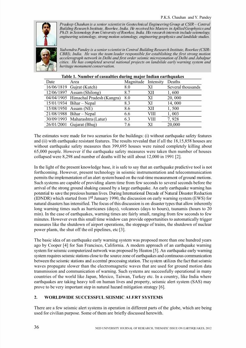
Pradeep Chauhan is a senior scientist in Geotechnical Engineering Group at CSIR – Central Building Research Institute, Roorkee, India. He received his Masters in Apllied Geophysics and Ph.D. in Seismology from University of Roorkee, India. His research interests include seismology,engineering seismology, strong motion seismology, engineering geophysics and landslide studies.
Yadvendra Pandey is a senior scientist in Central Building Research Institute, Roorkee (CSIR-CBRI), India. He was the team leader responsible for establishing the first strong motionaccelerograph network in Delhi and first order seismic microzonation of Delhi and Jabalpur cities. He has completed several national projects on landslide early warning system and heritage monument conservation.
The estimates were made for two scenarios for the buildings: (i) without earthquake safety featuresand (ii) with earthquake resistant features. The results revealed that if all the 18,15,858 houses arewithout earthquake safety measures then 399,695 houses were ruined completely killing about
65,000 people. However if the earthquake safety measures were taken then number of housescollapsed were 8,298 and number of deaths will be still about 12,000 in 1991 [2].
In the light of the present knowledge base, it is safe to say that an earthquake predictive tool is notforthcoming. However, present technology in seismic instrumentation and telecommunication
permits the implementation of an alert system based on the real-time measurement of ground motions.
Such systems are capable of providing alarm time from few seconds to several seconds before thearrival of the strong ground shaking caused by a large earthquake. An early earthquake warning has
potential to save the precious human lives. During International Decade of Natural Disaster Reduction(IDNDR) which started from 1st January 1990, the discussion on early warning system (EWS) for
natural disasters has intensified. The focus of this discussion is on disaster types that allow inherentlylong warning times such as hurricanes (days), volcanoes (days to hours), tsunamis (hours to 20min). In the case of earthquakes, warning times are fairly small, ranging from few seconds to few
minutes. However even this small time window can provide opportunities to automatically trigger measures like the shutdown of airport operations, the stoppage of trains, the shutdown of nuclear power plants, the shut off the oil pipelines, etc [3].
The basic idea of an earthquake early warning system was proposed more than one hundred years
ago by Cooper [4] for San Francisco, California. A modern approach of an earthquake warningsystem for seismic computerized network was proposed by Heaton [5]. An earthquake early warningsystem requires seismic stations close to the source zone of earthquakes and continuous communication between the seismic stations and a central processing station. The system utilizes the fact that seismicwaves propagate slower than the electromagnetic waves that are used for ground motion datatransmission and communication of warning. Such systems are successfully operational in many
countries of the world like Japan, Mexico, Taiwan, Turkey etc. In a country, like India whereearthquakes are taking heavy toll on human lives and property, seismic alert system (SAS) may
prove to be very important step in natural hazard mitigation strategy [6].
2. WORLDWIDE SUCCESSFUL SEISMIC ALERT SYSTEMS
There are a few seismic alert systems in operation in different parts of the globe, which are beingused for civilian purpose. Some of them are briefly discussed herewith.
Table 1. Number of casualties during major Indian earthquakes
Date
16/06/1819
12/06/1897
04/04/1905
15/01/1934
15/08/1950
21/08/1988
30/09/1993
26/01/2001
Area
Gujrat (Kutch)
Assam (Shilong)
Himachal Pradesh (Kangra)
Bihar – Nepal
Assam (NE)
Bihar – Nepal
Maharashtra (Latur)
Gujarat (Bhuj)
Magnitude
8.0
8.7
8.0
8.3
8.6
6.6
6.3
7.6
Intensity
XI
XII
XI
XI
XII
VIII
VIII
XI
Deaths
Several thousands
1, 600
20, 000
14, 000
1, 500
1, 003
7, 928
20,000
8/13/2019 Chauhan (Final)
http://slidepdf.com/reader/full/chauhan-final 3/9
NED UNIVERSITY JOURNAL OF RESEARCH, THEMATIC ISSUE ON EARTHQUAKES, 2012 37
2.1 Urgent Earthquake Detection and Alert System (UrEDAS) in Japan
The contemporary real time earthquake disaster prevention, earthquake detection and alarm systems(UrEDAS) used for railway in Japan consist of 30 strong motion instruments. The main feature of the system is utilizing the information from primary (P) wave data. Systems for different stationsare operational since 1983 [7]. UrEDAS detects initial P-wave motions estimates epicentre, azimuthand magnitude, calculates epicentral distance and depth within 3 sec. The station issues an alarmwhenever the preset level of horizontal acceleration is exceeded to 40 cm/sec2 (15.7 in/sec2) [8].
2.2 Seismic Alert System (SAS) for Mexico City
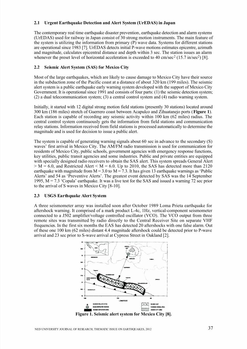
Most of the large earthquakes, which are likely to cause damage to Mexico City have their sourcein the subduction zone of the Pacific coast at a distance of about 320 km (199 miles). The seismicalert system is a public earthquake early warning system developed with the support of Mexico CityGovernment. It is operational since 1991 and consists of four parts: (1) the seismic detection system;(2) a dual telecommunication system; (3) a central control system and (4) radio warning system.
Initially, it started with 12 digital strong motion field stations (presently 30 stations) located around300 km (186 miles) stretch of Guerrero coast between Acapulco and Zihuatanejo ports ( Figure 1).Each station is capable of recording any seismic activity within 100 km (62 miles) radius. The
central control system continuously gets the information from field stations and communicationrelay stations. Information received from field stations is processed automatically to determine themagnitude and is used for decision to issue a public alert.
The system is capable of generating warning signals about 60 sec in advance to the secondary (S)waves’ first arrival in Mexico City. The AM/FM radio transmission is used for communication for residents of Mexico City, public schools, government agencies with emergency response functions,key utilities, public transit agencies and some industries. Public and private entities are equippedwith specially designed radio receivers to obtain the SAS alert. This system spreads General Alert> M = 6.0, and Restricted Alert < M = 6.0. Up to 2010, the SAS has detected more than 2120earthquake with magnitude from M = 3.0 to M = 7.3. It has given 13 earthquake warnings as ‘PublicAlerts’ and 54 as ‘Preventive Alerts’. The greatest event detected by SAS was the 14 September 1995, M = 7.3 ‘Copala’ earthquake. It was a live test for the SAS and issued a warning 72 sec prior to the arrival of S waves in Mexico City [8-10].
2.3 USGS Earthquake Alert System
A three seismometer array was installed soon after October 1989 Loma Prieta earthquake for aftershock warning. It comprised of a mark product L-4c, 1Hz, vertical-component seismometer connected to a J502 amplifier/voltage controlled oscillator (VCO). The VCO output from threeremote sites was transmitted by radio directly to the Central Receiver Site on separate VHFfrequencies. In the first six months the EAS has detected 20 aftershocks with one false alarm. Outof these one 100 km (62 miles) distant 4.4 magnitude aftershock could be detected prior to P-wavearrival and 23 sec prior to S-wave arrival at Cypress Street in Oakland [2].
Figure 1. Seismic alert system for Mexico City [8].
8/13/2019 Chauhan (Final)
http://slidepdf.com/reader/full/chauhan-final 4/9
P.K.S. Chauhan and Y. Pandey
NED UNIVERSITY JOURNAL OF RESEARCH, THEMATIC ISSUE ON EARTHQUAKES, 201238
2.4 Earthquake Alert System (EAS) for Romanian Capital
Romanian capital Bucharest has the most seismically active zone about 130 km (81 miles) away.Peculiarities of the Romanian intermediate depth seismicity, such as the stationery epicentres andthe stability of radiation pattern, and a line of site connection between epicentral area and the capital,allow designing a simple and robust EWS. An early warning system (EWS) based on the traveltime difference between P-wave and the destructive S-wave allows a warning time of 25 sec inBucharest. Warning decision is based on the amplitude of the P-wave which is directly related to
the level of ground motion in Bucharest due to stable source mechanism of the earthquakes [8, 11].
2.5 Early warning system for Turkey Capital
Ten strong motion accelerographs are installed near most active Great Marmara fault in ‘on-line’mode. Continuous telemetry of data between these stations and the main data centre is realized withdigital spread spectrum radio modem system involving repeater stations selected in the region.Considering the complexity of fault rupture and the short fault distances involved, a direct earlywarning algorithm based on the exceedance of specific threshold time domain amplitude level isimplemented. Whenever an earthquake occurs and 2 or 0 (selectable) station crosses the trigger threshold within selectable time interval, the first alarm is declared. The early warning information(consisting of three alarm levels) communicates to the servo shut down systems of strategic facilities.
Depending on the location of the earthquake and the recipient facility alarm time may be as highas about 8 sec [8, 12].
2.6 Real time Seismic Monitoring in Taiwan
Earthquake Rapid Reporting and Early Warning System in Taiwan uses real time strong motionaccelerograph network consists of 82 telemetered strong motion stations distributed across Taiwanand monitored by Taiwan Central Weather Bureau (CWB). It has achieved the generation of intensitymap, epicentre and magnitude within 1 min of the occurrence of a large earthquake, with the helpof its world’s densest seismic network. They aim to further reduce this time gap to 30 sec, so that100 km (62 miles) far earthquake may be studied within 20 sec and 10 sec may be made availablefor activation of emergency response measure [13, 14].
3. FEASIBILITY OF SEISMIC ALERT SYSTEM IN INDIA
The basic requirement of an earthquake early warning system is that the seismic field stations should be in the vicinity of the source zone of earthquakes and continuous communication (real time) between the seismic stations and central processing stations. The system works on the basis of thefact that seismic waves propagate slower than the electromagnetic waves that are used for groundmotion data transmission and communication of warning.
As soon as an earthquake occurs, P waves start travelling into the crust. This is the first measurable parameter of an earthquake. S waves follow P waves as they travel with slower speed, but in mostof the cases structural damages are caused by these slow moving S-waves. In the upper crust, lower crust and upper mantle layer P wave velocity is usually taken as 6 km/sec (3.7 miles/sec), 6.5 km/sec
(4 miles/sec) and 8 km/sec (5 miles/sec), respectively, and P wave velocity is w3 times the S-wavevelocity. The time between the onset of the earthquake and S waves time varies for different probablesources generating the earthquakes. If any earthquake epicentre is about 300 km (186 miles/sec)away from the central recording station, the alarm time (S-wave arrival after the earthquake triggers)will be more than one minute. This alarm time can help in evacuation of buildings in urban areas,shutting down the critical systems like nuclear reactors and chemical plants, stopping of high speedtrains and other modes of human transportation, shutting down the elevators etc.
India has a large part of its land area prone to major earthquakes. Geographical statistics of thecountry show that almost 54% of its land is vulnerable to earthquakes. According to seismic zoningmap of India, this 54% land lies in seismic zone III to V. Almost all the northern states, includingDelhi, fall in this part of the country. The major cities (starting from north to east) like Jammu,
Shimla, Chandigarh, Delhi, Dehradun, Lucknow, Patna, Ranchi, Kolkata, Guwahati, etc are locatedin this belt. Himalayan Seismic Gap (lying between the epicentres of the 1905 Kangra and the 1934Bihar-Nepal earthquakes) along the Main Central Thrust (MCT) may be considered as the most
8/13/2019 Chauhan (Final)
http://slidepdf.com/reader/full/chauhan-final 5/9
NED UNIVERSITY JOURNAL OF RESEARCH, THEMATIC ISSUE ON EARTHQUAKES, 2012 39
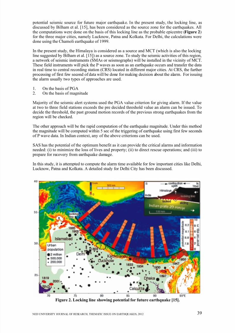
potential seismic source for future major earthquake. In the present study, the locking line, asdiscussed by Bilham et al. [15], has been considered as the source zone for the earthquakes. Allthe computations were done on the basis of this locking line as the probable epicentre (Figure 2)for the three major cities, namely Lucknow, Patna and Kolkata. For Delhi, the calculations weredone using the Chamoli earthquake of 1999.
In the present study, the Himalaya is considered as a source and MCT (which is also the lockingline suggested by Bilham et al. [15]) as a source zone. To study the seismic activities of this region,a network of seismic instruments (SMAs or seismographs) will be installed in the vicinity of MCT.These field instruments will pick the P waves as soon as an earthquake occurs and transfer the datain real time to central recording station (CRS) located in different major cities. At CRS, the further processing of first few second of data will be done for making decision about the alarm. For issuingthe alarm usually two types of approaches are used.
1. On the basis of PGA2. On the basis of magnitude
Majority of the seismic alert systems used the PGA value criterion for giving alarm. If the valueat two to three field stations exceeds the pre decided threshold value an alarm can be issued. Todecide the threshold, the past ground motion records of the previous strong earthquakes from the
region will be checked.
The other approach will be the rapid computation of the earthquake magnitude. Under this methodthe magnitude will be computed within 5 sec of the triggering of earthquake using first few secondsof P wave data. In Indian context, any of the above criterions can be used.
SAS has the potential of the optimum benefit as it can provide the critical alarms and informationneeded: (i) to minimize the loss of lives and property; (ii) to direct rescue operations; and (iii) to prepare for recovery from earthquake damage.
In this study, it is attempted to compute the alarm time available for few important cities like Delhi,Lucknow, Patna and Kolkata. A detailed study for Delhi City has been discussed.
Figure 2. Locking line showing potential for future earthquake [15].
8/13/2019 Chauhan (Final)
http://slidepdf.com/reader/full/chauhan-final 6/9
P.K.S. Chauhan and Y. Pandey
NED UNIVERSITY JOURNAL OF RESEARCH, THEMATIC ISSUE ON EARTHQUAKES, 201240
3.1 Delhi
Delhi falls in zone IV of Seismic Zoning Map of India and has prolonged seismic history. Crackson the wall of Qutab Minar tell the story of these past earthquakes. The 1720 earthquake of intensity
VIII-IX and the 1803 earthquake of intensity VIII are often mentioned in scientific literature. It has been highlighted time and again that Delhi region might face an earthquake of magnitude 7 in future.After experiencing the effects of the 1999 Chamoli earthquake in some parts of Delhi (particularlyin trans-Yamuna area), there is a heightened level of awareness among the public to natural disastersin urban areas. As far as seismic vulnerability of Delhi is concerned, there are six seismic sourcezones, which may affect Delhi region [16].
1. Himalayan Seismic zone2. Delhi-Haridwar Ridge zone3. Moradabad Fault zone4. Rajasthan Great Boundary Fault zone5. Mathura Fault zone
6. Sohna Fault zone
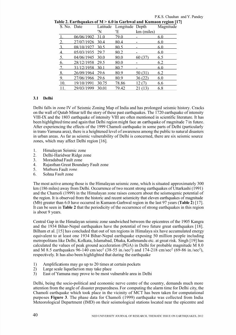
The most active among those is the Himalayan seismic zone, which is situated approximately 300km (186 miles) away from Delhi. Occurrence of two recent strong earthquakes of Uttarkashi (1991)and the Chamoli (1999) in the Himalayan zone raises concern about the seismogenic potential of the region. It is observed from the historic and recent seismicity that eleven earthquakes of magnitude(Mb) greater than 6.0 have occurred in Kumaon-Garhwal region in the last 97 years (Table 2) [17].It can be seen in Table 2 that the periodicity of the occurrence of strong earthquakes in this regionis about 9 years.
Central Gap in the Himalayan seismic zone sandwiched between the epicentres of the 1905 Kangraand the 1934 Bihar-Nepal earthquakes have the potential of two future great earthquakes [18].Bilham et al. [15] has concluded that out of ten regions in Himalaya six have accumulated energy
equivalent to at least one 1934 Bihar-Nepal earthquake exposing 50 million people includingmetropolitans like Delhi, Kolkata, Islamabad, Dhaka, Kathmandu etc. at great risk. Singh [19] hascalculated the values of peak ground acceleration (PGA) in Delhi for probable magnitude M 8.0and M 8.5 earthquakes 96-140 cm/sec2 (38-55 in./sec2) and 174-218 cm/sec2 (69-86 in./sec2),respectively. It has also been highlighted that during the earthquake
1) Amplifications may go up to 20 times at certain pockets2) Large scale liquefaction may take place3) East of Yamuna may prove to be most vulnerable area in Delhi
Delhi, being the socio-political and economic nerve centre of the country, demands much moreattention from the angle of disaster preparedness. For computing the alarm time for Delhi city, the
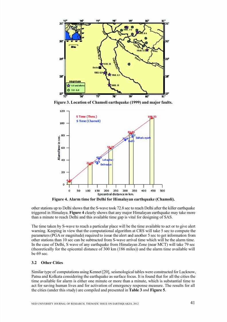
Chamoli earthquake which took place in the vicinity of MCT has been taken for computational purposes Figure 3. The phase data for Chamoli (1999) earthquake was collected from IndiaMeteorological Department (IMD) on their seismological stations located near the epicentre and
S. No.
1.
2.
3.
4.
5.6.
7.
8.
9.
10.
11.
Date
06/06/1902
27/07/1926
08/10/1927
05/03/1935
04/06/194528/12/1958
31/12/1958
26/09/1964
27/06/1966
19/10/1991
29/03/1999
Latitudeo N
31.0
30.4
30.5
29.7
30.029.5
30.1
29.6
29.6
30.75
30.01
LongitudeoE
79.0
80.4
80.5
80.2
80.080.0
80.7
80.9
80.9
78.86
79.42
Depth
km (miles)
-
-
-
-
60 (37)-
-
50 (31)
36 (22)
12 (7)
21 (13)
Magnitude
6.0
6.0
6.0
6.0
6.56.2
6.0
6.2
6.0
6.6
6.8
Table 2. Earthquakes of M > 6.0 in Garhwal and Kumaon region [17]
8/13/2019 Chauhan (Final)
http://slidepdf.com/reader/full/chauhan-final 7/9
NED UNIVERSITY JOURNAL OF RESEARCH, THEMATIC ISSUE ON EARTHQUAKES, 2012 41
other stations up to Delhi shows that the S-wave took 72.8 sec to reach Delhi after the killer earthquaketriggered in Himalaya. Figure 4 clearly shows that any major Himalayan earthquake may take morethan a minute to reach Delhi and this available time gap is vital for designing of SAS.
The time taken by S-wave to reach a particular place will be the time available to act or to give alertwarning. Keeping in view that the computational algorithm at CRS will take 5 sec to compute the parameters (PGA or magnitude) required to issue the alert and another 5 sec to get information fromother stations than 10 sec can be subtracted from S-wave arrival time which will be the alarm time.In the case of Delhi, S wave of any earthquake from Himalayan Zone (near MCT) will take 79 sec(theoretically for the epicental distance of 300 km (186 miles)) and the alarm time available will be 69 sec.
3.2 Other Cities
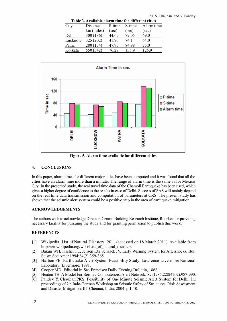
Similar type of computations using Kennet [20], seismological tables were constructed for Lucknow,Patna and Kolkata considering the earthquake as surface focus. It is found that for all the cities the
time available for alarm is either one minute or more than a minute, which is substantial time toact for saving human lives and for activation of emergency response measure. The results for allthe cities (under this study) are compiled and presented in Table 3 and Figure 5.
Figure 3. Location of Chamoli earthquake (1999) and major faults.
Figure 4. Alarm time for Delhi for Himalayan earthquake (Chamoli).
8/13/2019 Chauhan (Final)
http://slidepdf.com/reader/full/chauhan-final 8/9
P.K.S. Chauhan and Y. Pandey
NED UNIVERSITY JOURNAL OF RESEARCH, THEMATIC ISSUE ON EARTHQUAKES, 201242
Table 3. Available alarm time for different cities
City
Delhi
Lucknow
Patna
Kolkata
Distance
km (miles)
300 (186)
325 (202)
280 (174)
550 (342)
P-time
(sec)
44.65
41.90
47.95
76.27
S-time
(sec)
79.05
74.1
84.98
135.9
Alarm time
(sec)
69.0
64.0
75.0
125.9
Figure 5. Alarm time available for different cities.
4. CONCLUSIONS
In this paper, alarm times for different major cities have been computed and it was found that all thecities have an alarm time more than a minute. The range of alarm time is the same as for MexicoCity. In the presented study, the real travel time data of the Chamoli Earthquake has been used, whichgives a higher degree of confidence to the results in case of Delhi. Success of SAS will mainly dependon the real time data transmission and computation of parameters at CRS. The present study hasshown that the seismic alert system could be a positive step in the area of earthquake mitigation.
ACKNOWLEDGEMENTS
The authors wish to acknowledge Director, Central Building Research Institute, Roorkee for providing
necessary facility for pursuing the study and for granting permission to publish this work.
REFERENCES
[1] Wikipedia. List of Natural Disasters, 2011 (accessed on 18 March 2011). Available fromhttp://en.wikipedia.org/wiki/List_of_natural_disasters
[2] Bakun WH, Fischer FG, Jensen EG, Schaack JV. Early Warning System for Aftershocks. BullSeism Soc Amer 1994;84(2):359-365.
[3] Harben PE. Earthquake Alert System Feasibility Study. Lawrence Livermore NationalLaboratory, Livermore: 1991.
[4] Cooper MD. Editorial in San Francisco Daily Evening Bulletin, 1868.[5] Heaton TH. A Model For Seismic Computerized Alert Network. Sci 1985;228(4702):987-990.
[6] Pandey Y, Chauhan PKS. Feasibility of One Minute Seismic Alert System for Delhi. In: proceedings of 2nd Indo-German Workshop on Seismic Safety of Structures, Risk Assessmentand Disaster Mitigation. IIT Chennai, India: 2004. p.1-10.
8/13/2019 Chauhan (Final)
http://slidepdf.com/reader/full/chauhan-final 9/9
NED UNIVERSITY JOURNAL OF RESEARCH, THEMATIC ISSUE ON EARTHQUAKES, 2012 43
[7] Nakamura Y. Earthquake Alarm System for Japan Railways. Japan Rail Eng 1989;28(4):3-7.[8] Erdik M. Urban Earthquake Rapid Response and the Early Warning System. In: First European
Conference on Earthquake Engineering and Seismology. Geneva: 2006.[9] Espinosa-Aranda J, Rodriquez-Cayeros FH. The Seismic Alert System of Mexico City. In:
Lee WKH, Kanamori H, Jennings PC, and Kisslinger, Editors. International Handbook of Earthquake and Engineering Seismology, Academic Press, 2003. p. 1253-1260.
[10] Espinosa-Aranda JM, Cuellar A, Rodriquez-Cayeros FH, Frontana B, Ibarrola G, Islas R,Gracia A. The Seismic Alert System of Mexico (SASMEX): Progress and its Current
Applications. J Soil Dyn Earthq Eng 2011;31(2):154-162.[11] Wenzel F, Baur M, Fiedrich F, Ionescu C, Oncescu MC. Potential of Earthquake Early Warning
System. Nat Haz 2001;23(2-3):407-416.[12] Erdik M, Fahjan Y, Ozel O, Alcik H, Mert A, Gul Ml. Istanbul Earthquake Rapid Response
and the Early Warning System. Bull Earthq Eng 2003;1(1):157–163.[13] Teng T, Wu L, Shin TC, Tsai YB, Lee WHK. One Minute After: Strong Motion Map, Effective
Epicenter and Effective Magnitude. Bull Seism Soc Amer 1997;87(5):1209-1219.[14] Wu YM, Teng TL. A virtual sub-network approach to earthquake early warning. Bull Seism
Soc Amer 2002;92(5):2008-2018.[15] Bilham R, Gaur VK, Molnar P. Himalayan Seismic Hazard. Sci 2001;293(5534):1442-1444.[16] Sharma ML, Wason HR, Dimri R. Seismic Zonation of Delhi Region for Bed Rock Ground
Motion. Pure App Geophy 2003;160(12):2381-2398.
[17] Dimri VP. Earthquake Hazard Assesment of Kumaon-Garhwal Himalaya Through the Applicationof Fractal Technique. In: 9th IGC Foundation Lecture. Dehradun, India. 2003[18] Khattri KN. An Evaluation of Earthquake Hazard and Risk in Northern India. Hima Geo
1999;20(1):1-46.[19] Singh SK. Ground Motion in Delhi from Future Large/Great Earthquakes in the Central
Seismic Gap of the Himalayan Arc. Bull Seism Soc Amer 2002;92(2):555-569.[20] Kennett. IASPEI 1991 Seismological Tables. Research School of Earth Sciences, Australian
National University, Canberra, 1991. p 167.[21] Arya AS. Recent Developments towards Earthquake Risk Reduction in India. Cur Sci
2000;79(9):1270-1277.