cheshire historic towns survey€¦ · although the manor was recorded in the domesday survey ......
TRANSCRIPT

CHESHIRE HISTORIC TOWNS SURVEY
Sandbach
Archaeological Assessment
2003

CHESHIRE HISTORIC TOWNS SURVEY
Sandbach
Archaeological Assessment
2003
Environmental Planning Cheshire County Council
Backford Hall Backford Chester
CH1 6PZ These reports are the copyright of Cheshire County Council and English Heritage. The Ordnance Survey mapping within this document is provided by Cheshire County Council under licence from the Ordnance Survey, in order to fulfil its public function to make available Council held public domain information. The mapping is intended to illustrate the spatial changes that have occurred during the historical development of Cheshire towns. Persons viewing this mapping should contact Ordnance Survey copyright for advice where they wish to licence Ordnance Survey mapping/map data for their own use. The OS web site can be found at www.ordsvy.gov.uk Front cover : J Cowley, 1744 An Improved Map of Cheshire, Containing the Borough and Market Towns, with those adjoining; also its Principal Roads and Rivers Cheshire and Chester Archives and Local Studies, PM 2/20.

SANDBACH
ARCHAEOLOGICAL ASSESSMENT
Vince Devine & Jo Clark 1. SUMMARY Although the manor was recorded in the Domesday Survey of 1086, very little is known about Sandbach during the early medieval period. However, the survival of elaborate pre-Viking sculpture, in the form of crosses and grave slabs, indicates that Sandbach was an important religious centre during this period. By the late 16th century the town was granted the rights to hold a market and two fairs, all of which have continued into the present century. During the 19th century, a silk and shoe industry were established, and their commercial success was a significant factor in the growth of the town. 1.1 Topography and Geology Sandbach lies in south-east Cheshire at around 19m AOD, in an area of flat to gently undulating dairy farming land, between the valleys of the river Wheelock and Dane. It is approximately 7 km to the north-east of Crewe, and 8 km to the south-east of Middlewich. A tributary stream of the river Wheelock runs through the settlement on a north-south alignment. The underlying geology is Middle Keuper Marl, with a narrow band of glacial sand and gravel running south-west, north-east through the town (Geological Survey of Great Britain1953). This is overlain by sandy gley soils, which are suited to mixed arable and grassland and are graded classes 2-3 (Furness 1978, 164). The town is situated at the junction of a number of roads, including the A533 to Middlewich and Alsager, and the A534 to Crewe and Congleton. The M6 passes 1 mile to the east of the town. 1.2 Administrative Unit During the medieval period the township of Sandbach was located within Middlewich Hundred, until the 13th century when reorganisation of the hundreds saw the focus shift from Middlewich to Northwich (Dunn 1987, 31). The medieval parish of Sandbach included seven townships, some of which were situated in adjacent hundreds (Ormerod 1882, 2a). It was also included in the Middlewich Deanery (Dunn 1987, 19). The parish was still extensive during the post medieval period, and in 1874 covered an area of 16,310 acres (Morris and Co, 1874, 580). The modern township is in the civil parish of Sandbach, in the Borough of Congleton. 1.3 Place Name The earliest reference to Sandbach appears in the Domesday Survey when it was recorded as Sanbec. During the medieval and post medieval periods, Sandbach was recorded as Sanbache (1308), Sanebach (1308), Sondabache (1498),
Cheshire Historic Towns Survey 1 © Cheshire County Council and English Heritage 2003

Sanbache (1560) and Sanbech (1629). The name refers to a ‘Sandy valley-stream’ (Dodgson 1970, 269), presumably a reference to the local tributary stream of the River Wheelock. 2. SOURCES 2.1 Historical Ormerod’s History of Cheshire (1882) and Earwaker’s A History of the Ancient Parish of Sandbach (1890) both chronicle the ecclesiastical and manorial histories of the town. However, Tomlinson’s A History of Sandbach (1899) provides the only detailed history of the town. More recently a number of small pamphlets and general topographical descriptions have been published, the best of these being by Massey (1958 and 1967). 2.2 Cartographic The earliest maps to depict the settlement of Sandbach are Saxton’s map of Cheshire (1577) and Speed’s county map (1610). Burdett’s county map of 1777 is the first to show an outline plan of the town and the road network, but the first maps to show the town in detail are the tithe map of 1840 and the Ordnance Survey First Edition 6”: 1 mile map surveyed in 1873. 2.3 Archaeological The Cheshire Sites and Monuments Record (CSMR) records twenty five sites in the Sandbach area, ranging from the Bronze Age to the industrial period and these are depicted on Figure 1. The present survey has generated four new sites. Throughout this document the relevant reference is provided for any records that have been identified from the CSMR. In 1981 two archaeological excavations were undertaken to assess the archaeological potential around the central market area. The first excavation was located to the rear of the Crown Hotel (CSMR 1109/0/11, RCHME UID 649568). Three trenches were cut, all of which revealed that the archaeological deposits were truncated by modern activity. However, archaeological data was recovered: a ditch measuring over 2 metres wide and 1 metre deep was discovered, and was tentatively interpreted as a possible boundary ditch of a medieval property plot. A second trench exposed the base of a truncated medieval ditch, which produced a pottery assemblage dating from the 14th and 15th centuries, and at the eastern end of the cutting were two areas of partly fired clay and charcoal, which may have been the remains of a medieval clay-lined oven, although no dating evidence was recovered (Smart and Samuels 1981a, 2). The second area of archaeological investigation was undertaken on derelict land adjacent to the north-east side of Hawk Street (CSMR 1109/0/12; RCHME UID 649567), which is one of the streets linking Crown Lane with Scotch Common. These excavations revealed three (probable) 18th-century cottages, below which it was possible to identify three phases of development. The southernmost cottage
Cheshire Historic Towns Survey 2 © Cheshire County Council and English Heritage 2003

overlaid a timber framed structure constructed upon ‘padstones’, on a similar alignment, which may have been of medieval date (Smart and Samuels 1981b, 3). A watching brief was carried out by Earthworks Archaeological Services in July 1999 on land to the south of Scotch Common. Despite its location close to the town’s historic core the features that were recovered were of an 18th and 19th century date. Pits and gullies of a stratigraphically earlier date were identified but unfortunately no dating evidence was recovered to indicate how much earlier these features were (Earthworks 1999, 2). In September 1999, the University of Manchester undertook a watching brief at a site north of Church Street and west of Bath Street. This revealed finds dating to the late 19th and early 20th centuries (UMAU 1999, 14). 3. HISTORICAL AND ARCHAEOLOGICAL SUMMARY 3.1 Prehistoric Although there is no evidence of prehistoric activity in Sandbach, there is a scatter of prehistoric sites and find spots in the surrounding area. Aerial photography has revealed a ring ditch 1km to the south-east of the town centre at Sandbach Heath, which has been interpreted as a possible ploughed out Bronze Age round barrow (CSMR 2444) ; and flints have been reported 0.5km north-east of the town centre in what is now a modern suburb of Sandbach, although this claim is unsubstantiated (CSMR 1106). Unidentified metal objects of prehistoric date have been discovered 1.8km north-east of the town centre and 2.8km south-east (CSMR 2502 and CSMR 1115). 3.2 Roman A section of the King’s Street Roman road (CSMRs 436/1/9, 436/1/12, and 436/1/13), runs 1.75km to the west of Sandbach on a north-west to south-east alignment. Archaeological evidence of Romano-British activity within the town is more ephemeral however, comprising a late 2nd to early 3rd century grooved jar, and a single sherd of red pottery (CSMR 1107), which was found just off Green Street, due west of Scotch Common. 3.3 Early Medieval At Domesday the manor of Sandbach was held jointly by two ‘fiefs’, as part of their large but dispersed estates. The first was Bigot de Loges whose scattered fiefdom contained thirteen manors, whilst Earl Hugh had holdings that amounted to some fifty manors in Cheshire (Thacker in Harris 1987, 305-13). The Domesday Survey records that: ‘The same Bigot [who] holds SANBECD [Sandbach]. Dunning held it and was free. There [is] one hide that pays geld, and one and a half virgates that likewise pay geld. The land is for two ploughs. There is one Frenchman with half plough and three serfs, and two villeins with half plough. There [is] a priest and a church. Wood half a league long and four perches wide. T.R.E. it was worth 4s., now 8s’.
Cheshire Historic Towns Survey 3 © Cheshire County Council and English Heritage 2003
and ‘The same earl [Hugh] [who] holds SANBEC [Sandbach] of two and a half virgates that pay geld, and Clive [Clive in Middlewich] of one virgate that pays geld, and SUTONE [Sutton in Middlewich] of four bovates of land that pay geld, and WIBALDELAI [Wimbldsley in Middlewich] of one virgate of land that pays geld, and ACULVESTUNE [Occlestone in Middlewich] of one hide that pays geld. Six free men held these lands as six manors. In all there is land for seven ploughs. The whole was and is waste’. (Harris and Thacker 1987, 360 and 348) It appears that Bigot’s moiety contained the settlement of Sandbach, as it includes the church and was valued at 8s, whilst Earl Hugh’s was described as ‘The whole was and is waste’ and may have comprised only agricultural land (Harris and Thacker 1987, 348). The presence of a number of pre-Viking sculptures in Sandbach suggests that an early medieval minster may have been located at Sandbach. The best known of these sculptures are the two crosses (CSMR 1109/0/1, SAM 23637) which now stand in the market place. The smaller of the two is an amalgamation of two crosses, whilst in the churchyard the remains of a further cross can be seen (CSMR 1109/0/2). Although such crosses were erected in a number of topographical locations and could perform various functions, Thacker suggests that that the Sandbach crosses are ‘of a kind associated with important pre-Viking ecclesiastical enclosures’. It has been suggested that there was perhaps a minster church in Sandbach (Harris and Thacker 1987, 276). The iconography of most pre-Viking sculpture of Mercia and Northumbria lies in a monastic context aimed at a specific section of the population, whereas the iconography of the Sandbach crosses appears to be aimed at both monastic and secular Christian audiences, and it is for the latter that they were probably produced. Higham also suggests that while the Sandbach minster church may not have been monastic, it was nevertheless in contact with the highest ecclesiastical authorities in the region (Higham, 1983, 168). In addition, it is likely that the church patronised an associated ‘school of sculpture’, which is described as ‘...an active sculptural workshop centred on Sandbach early in the 9th century, which was in contact with current developments in continental Europe and interested in complex but canonical theological concerns’ (Higham 1983, 167). The churchyard of St. Mary’s church is depicted as circular on the OS First Edition 6”: 1mile map (1873), a shape which is often associated with early medieval ecclesiastical foundations (Friar 1991, 75). The church and churchyard are located on a steeply elevated site, thus creating a prominent local landmark. The churchyard also provides the location for two pre-Viking tombs slabs (CSMR 1109/0/2). The church of St Mary’s has undergone numerous phases of rebuilding and it is reputed that an earlier structure was revealed when the 15th-century church was
Cheshire Historic Towns Survey 4 © Cheshire County Council and English Heritage 2003

demolished (CSMR 1109/1/1), although the source of this reference is unclear. Higham suggests that the minster church may have been ministering to a parochia, comprising the parishes of Middlewich, Warmington, Davenham and Sandbach (Higham 1993, 166). Yet, by the mid-13th century the parish had been reduced to just a core area around the church and a detached chapelry and eventually two chapelries - Holmes Chapel and Goostrey. The fate of the minster is unknown but it is possible that along with a number of other ecclesiastical foundations, Sandbach may well have become a ‘...victim of the Vikings’, sometime during the late 9th century (ibid, 104). It is not known whether the church mentioned at Domesday was that of the early medieval Minster or a later medieval construction. No doubt there was a continuity of tradition. 3.4 Medieval 3.4.1 The Manor By the early 13th century the ‘mesne lords’ had assumed the local name, with Richard de Sandbache the first individual recorded. A full genealogy of this family can be found in Ormerod (1882, 95-104). The value and some components of Sandbach manor were recorded in a Inquisition Post Mortem (IPM) of 1434-35, and included ‘...one hall, two chambers, one chapel, one stable, and one kitchen (of no value), 48 messuages, 500 acres of land, and 40 of meadow (of the yearly value of 39 marks), 40 of wood, 100 of moss (yearly value 20s 3d), 3 ponds (yearly Val. 4 marks), and 13s 10d rent. The total value per annum of the whole manor was £30 10s 2d’ (Ormerod 1882, 97). The above reference clearly shows that the demesne manor was extensive, and presumably larger than the six hundred and eighty acres recorded, as the lord was also receiving 13s. 10d in rent. Also in the same year William Radcliff of Urdessall is documented as holding a ‘moiety of the manor of Sondebach, valued per annum at. £12 1s 9d’ (ibid, 97). In 1486-87, John Ford was recorded as owning an estate at ‘Abbeyfield’ (Ormerod 1882, 100), the location of which is unknown. A house within extensive gardens called ‘Abbeyfields’ is located to the south-west of Sandbach, running westwards from Park Lane, although any relationship to the medieval estate is unknown. Traditionally the medieval manor house is thought to have stood on the site now occupied by a 17th-century building called ‘The Old Hall’ (Earwaker 1890, 2-9, and Ormerod 1882 6-7; CSMR 1109/2/1). However, there is no archaeological evidence to substantiate this. 3.4.2 Settlement Many medieval settlements were clustered around the church and/or the market place (Aston and Bond 1976, 78-108, Hindle 1990, 21-29), a situation which may be evident at Sandbach. Excavations undertaken in 1981 in the central market area of the town, although only small scale, clearly show that archaeological deposits dating from the medieval period do survive in the historic core of Sandbach. This evidence
Cheshire Historic Towns Survey 5 © Cheshire County Council and English Heritage 2003

comprises domestic settlement, including a potential oven, enclosed within property boundaries (see 2.3). 3.4.3 Economy Agriculture was no doubt a dominant economic force but unfortunately there are no surviving references to indicate what other industrial or commercial enterprises were undertaken in Sandbach. Data for Cheshire towns is rare because in the medieval period the shire was exempt from national taxation, having its own taxation system, the Mize. There was a successful local economy in early 15th century Sandbach, as indicated by the ‘Cheshire Mize’ returns for Sondebache of 60s. 10d in 1405. This was a respectable sum, which ranked ninth in the county survey, and is comparable with Malpas (64s) and Audlem (66s 8d) (Booth, 1985). Sandbach did not have a borough charter and it did not receive its market charter until 1578-9, but this Crosby suggests may well have simply ‘legalised’ what was a much earlier informal event (Crosby 1996, 49). Sandbach Mill (CSMR 1118/1) was rebuilt in 1872, but it can be dated back to 1423 (Bott 1983, 65). The mill is located in the southern area of the modern settlement on Mill Hill Lane, 1km south-west of Sandbach. This ‘overshot’ mill drove three pairs of stones, and had a drying kiln attached to the side. The waterwheel was the main source of power until 1963, when it was converted to electricity (Norris 1965, 75-6). 3.4.4 Religion Whether Sandbach’s early medieval, minster church continued to function into the medieval period is unclear, although a priest and church were recorded at Domesday. The earl of Chester held the advowson of the church until c 1230, when it was granted to the Cistercian monastery of Dieulacres, Staffordshire, who also received the appropriation in 1256 (Ormerod 1882, 104). The value of the church in the Taxatio Ecclesiastica of 1291 was £22 13s 4d, a figure which had fallen to £15 10s 2.5d by the Valor Ecclesiasticus of 1535 (Ormerod 1882, 104). There is reference to the church in 1434-5 (Ormerod 1882, 97), a structure which may have been replaced by another church erected during the reign of Henry VII (1485-1508). This latter building may have been constructed in Perpendicular style, as a later rebuilding of the west tower is said to have been an exact reproduction of the original tower (Pevsner and Hubbard 1971,330). 3.4.5 The Surrounding Area There are a number of medieval sites in the surrounding area. These include a moated site at Bradwall 2km to the north (CSMR 1097), and Wheelock Mill 2km to the south (CSMR 1132/1). 3.5 Post Medieval 3.5.1 The Manor By the mid-19th century, Lord Crewe was the principal landowner at Sandbach and lord of the manor (Bagshaw, 1850, 489).
Cheshire Historic Towns Survey 6 © Cheshire County Council and English Heritage 2003

3.5.3 The Civil War During the 17th century English Civil War ‘Scotch Common’ was the scene of a skirmish between a band of Scottish troops (returning from the Battle of Worcester) and the local population, hence the prefix to the common’s name (Ormerod 1882, 104). 3.5.4 Settlement The earliest post medieval reference to the settlement of Sandbach dates from c1579, when it was described as ‘Sandbach (commonly called Sandbetch) standeth on a high bank upon the small river of wheelock, and is but a little town with a fair church of stone, lately made a market town...In the market place stand together two Crosses of Stone, on steps, with certain images, and writings thereon graven; which, as they say cannot be read, except be be-holden with his head downwards’ (Earwaker 1890, 10). This reference probably refers to the area of Sandbach to the east of the market place and to the west of the town bridge. The bridge may have been built as early as 1777, although a date of 1825 is also mentioned (Massey 1958, 11-17). The original method of crossing the stream was probably by a ford, which may account for the bridge’s omission from the above description. In 1579 ‘Ottiwell Kinsey’ was recorded as master of Sandbach School, and by 1677 a ‘Free School’ had been established, financed principally by Francis Wells of Sandbach and John Welles of Crewe. The school appears to have provided a first class education, as at least five of its pupils attained university places. By the 1830s the Grammar School had become dilapidated, and was still bereft of an associated ‘master’s’ house but in 1849-50, sufficient funds had been acquired, enabling Sir Gilbert Scott to be commissioned to design and build the present Grammar School on Crewe Road (CSMR 1109/5). Other schools in Sandbach include the National School established in the Old Temperance Hall in 1841, and the Wesleyan School in Chapel Street (Massey 1939-40). The cutting of the Trent and Mersey Canal c 1775 at Wheelock (to the south), and the later laying on of a rail link (1840) at Elworth (to the west), encouraged the establishment of the local industrial base, which in turn stimulated the expansion of Sandbach (Massey 1958, 13). This urban growth resulted in modifications to the town plan, where ‘Some of the streets in the more ancient parts are narrow, but since the increase of manufacturing, the thoroughfares have been improved...’ (Kelly 1892, 417). Included within this ‘improvement’ was the raising of the High Street to the level of the new bridge (Tomlinson 1899, 38-9), an action which resulted in the original east-west route through the town (directly to the south of the church) becoming redundant, and the churchyard being enlarged (Massey 1958, 11). The principal area of new development was in ‘Hightown’, located to the north-west of Sandbach’s historic core. Sandbach possessed two gasworks, the first established near Brook Silk Mill (1841-74), provided the public supply, whilst the second supplied gas to the salt and chemical works at Wheelock (Massey 1958, 19).
Cheshire Historic Towns Survey 7 © Cheshire County Council and English Heritage 2003

In 1844 two of Sandbach’s poor houses were replaced by the Arclid Workhouses (Massey 1957, 37), however the latter’s precise location is unclear. By 1850 plans were made to erect a group of almshouses on the Newcastle road, the building of which was to be undertaken, after the completion of a school. The almshouses were finally erected between 1865-7, at a cost of £2600 and provided accommodation for twenty inmates (Bagshaw 1850, 489). In 1857 a ‘Reading Room’ was opened, and the ‘Commons House’ on Scotch Common was bequeathed to the Urban District Council, in order to be used for the public benefit (Massey 1958, 18). 3.5.5 Economy In 1578 Sir John Ratcliffe of Ordsall obtained a charter, granting him the rights to hold a market and two fairs at Sandbach. The market was to be held on a Thursday, and the two fairs were to be held on the Tuesday and Wednesday of Easter week and on the Thursday and Friday before the Nativity of our Lady (8 September). Tomlinson records that Ratcliffe had ‘considerable trouble in obtaining a grant [however] The market proved an immense success’ (Tomlinson 1889, 26). The ‘Market Hall’ or ‘Old Town Hall’ was constructed upon two sets of brick piers, and stood in the south of the market place. The space between the building’s peers which faced into the market square was used for the incarceration of prisoners on one side, and for shops on the other, whilst the space on the opposite side, facing onto the High Street, was ‘...on market days, devoted to farmers wives with butter and eggs, and butchers and their stalls’ (Tomlinson 1889, 26). In 1889 the Old Town Hall was replaced by the present hall (located opposite Welles Street) at a cost of £5000. This spacious new building, had the capacity to hold up to eight hundred people, and the old market hall was demolished in 1891 (Kelly 1914, 418). The market place was still used as a venue for smaller subsidiary markets, including a Saturday ‘provisions’ market (Morris and Co, 1874) and a wholesale market (Tomlinson 1889, 26). The rights to the tolls and stallage appear to have descended with the manor (Sir John Ratcliffe was the manorial lord in 1578) until 1889, when the Rt. Hon Hungerford Lord Crewe presented them to the town (Tomlinson 1889, 26). By 1874 the fairs were held on Easter Tuesday, the first Thursday after the 12 September, and on the 28 December, the latter being ‘a large cattle and pleasure fair, with a statute for hiring servants’ (Morris and Co 1874, 580). Scotch Common was still a venue for public events until at least the 1930s. During the 17th century Sandbach was noted for the quality of its ales (Bagshaw 1850, 489), although production appears to have ceased by the late 19th century. Associated with this trade were the beerhouses, public houses and inns of the town. The earliest surviving public houses are the ‘Lower Chequer Inn’ (CSMR 1109/0/4), which dates from the late 16th or early 17th centuries, the Black Bear Inn (CSMR 1109/0/13) dated 1634, and the 17th century Fox Inn (CSMR 1310). In 1850 there were twelve establishments recorded as either hotels, inns, taverns, or ‘beerhouses’ (Bagshaw 1850, 489).
Cheshire Historic Towns Survey 8 © Cheshire County Council and English Heritage 2003

In 1782 Broster’s Chester and Cheshire Guide lists among the inhabitants of Sandbach, a mercer, a draper, a corn dealer, a grocer, a haberdasher, a surgeon, an iron monger, an attorney-at-law, and a cheese factor (Earwaker 1890, 87). This register of occupations provides an example of the typical trades undertaken in a small settlement during this period. Exhaustive lists of other occupations practised by the population of the town from the mid-19th, to the early 20th centuries can be found in Bagshaw (1850), Morris and Co (1874), and Kelly (1892, 1914 and 1939). A textile industry had been established in the Sandbach area by c1809, when the Wheelock Mill was constructed (Calladine and Fricker 1993, 67). By 1850 ‘There [was] an extensive establishment for silk throwing, employing upwards of 500 hands’ (Bagshaw 1850, 489). Two Silk Mills (The Brooke Mill and Newfield Mill) are shown on the Ordnance Survey First Edition map of 1873. The Commons Mill and the Town Mill are both recorded as being in Sandbach, however it is unclear whether these are the same two factories as above (whose names have changed), or were separate commercial enterprises. The trade was still flourishing in 1882, when Ormerod comments upon the importance of silk throwing to the prosperity of the town (Ormerod 1882, 98). The regional silk industry may have begun to decline from the mid 19th century, and in towns such as Congleton the effects of this decline were offset by the establishment of a fustian-cutting industry (Calladine and Fricker 1993, 105). The fate of the Sandbach silk industry is unclear, however fustian cutting was eventually introduced to the Commons Factory and the Town Mill (Massey 1957, 20). Other textiles were produced at Sandbach, such as Worstead yarn and ‘stuffs for country wear, [which] were manufactured in large quantities by its inhabitants’ (Bagshaw 1850, 489). Other associated trades such as tailoring can be found in the trade references given above. Another staple trade was that of boot and shoe making (Ormerod 1882, 98), with twenty two residents being associated with the trade in 1850 (Bagshaw 1850, 489). 3.5.6 Religion William Smith recorded that the Sandbach Crosses were still standing in the market place c1585 (Earwaker 1890, 10). It is not known when they were taken down but during the late 17th century, parts of the crosses were removed by Sir John Crewe to Utkinton, and then eventually relocated to the rectory house of Tarporley. In 1816, following the requests of the residents of Sandbach, a Mr John Palmer re-erected the crosses in the town’s market place (Ormerod 1882, 95-104). The parish church of St. Mary’s (CSMR 1109/1/1) underwent periodic remodelling and rebuilding throughout the post medieval period. The building retains some mid 17th century architectural features, including a number of roof corbels, and masonry on its south side. Between 1847-9 the Church of St. Mary’s was rebuilt by the noted architect George Gilbert Scott. Scott was also the architect of the Church of St. John on Sandbach Heath, which was completed in 1861. The church is built in his favourite ‘Early English’ style, with a crossing tower (Pevsner and Hubbard 1971, 331). The Wesleyan movement was represented in the town as early as 1744, and by 1785 it had twenty members, a figure which had risen to 100 in 1807. In 1872 a
Cheshire Historic Towns Survey 9 © Cheshire County Council and English Heritage 2003

chapel was built on the Middlewich road, although occasional services were held at the Commons Silk Factory. An Independent (Congregational) chapel was erected on Hope Street in 1836, with a Sunday School and burial ground established by 1860, and a new schoolroom added in 1893. In 1832 Primitive Methodists met in a small brick chapel on Union Street, as well as in a chapel at Ettiley Heath. A United Methodist Chapel was located on the Bradwell Road (Massey 1967, 30-1; Bagshaw 1850, 489; Morris and Co 1874, 580). 3.5.7 Transport and Communications Sandbach is situated at the junction of a number of important routeways, a location which encouraged the establishment of a number of stagecoach services. In 1822 the London Service called at the George Hotel, whilst other services were run daily to Liverpool and Manchester (Massey 1958, 32-3). The ‘Grand Trunk Canal’, later known as the Trent and Mersey Canal, was cut c1775 by the engineer James Brindley. Although the canal did not pass directly through Sandbach, the nearby settlements at Wheelock and Elworth were located on route. This new transport system undoubtedly provided the commercial incentive for the expansion of the existing salt industry at Wheelock, and is likely to have had a positive effect upon the industries of Sandbach. In 1840 the Manchester to Crewe railway (also known as the Manchester to Birmingham Line) was constructed, a section of which ran through Elworth, to the west of Sandbach. By 1860 there were seven trains a day calling at Elworth Station (CSMR 2528/1/37). A second line was laid at Elworth, forming the Sandbach to Winsford Junction (CSMR 2528/1/36). 3.5.8 Population The population of Sandbach in 1664 has been estimated from the hearth tax as numbering 664 (MacGregor, 1992, 100). For the 19th century and later, population information can be obtained from the Census returns, which are published in the Victoria County History (Harris 1979, 230), and for 1981 and 1991 census data has been reproduced under Class Licence Number C01W0000125 with the permission of the Controller of the HMSO.
1801 1844 1901 5558 1811 2311 1911 5723 1821 2905 1921 5864 1831 3710 1931 6411 1841 4587 1951 9523 1851 4659 1961 9862 1861 4989 1971 13306 1871 5259 1981 14805 1881 5493 1991 15839 1891 5824
3.5.9 The Surrounding Area
Cheshire Historic Towns Survey 10 © Cheshire County Council and English Heritage 2003

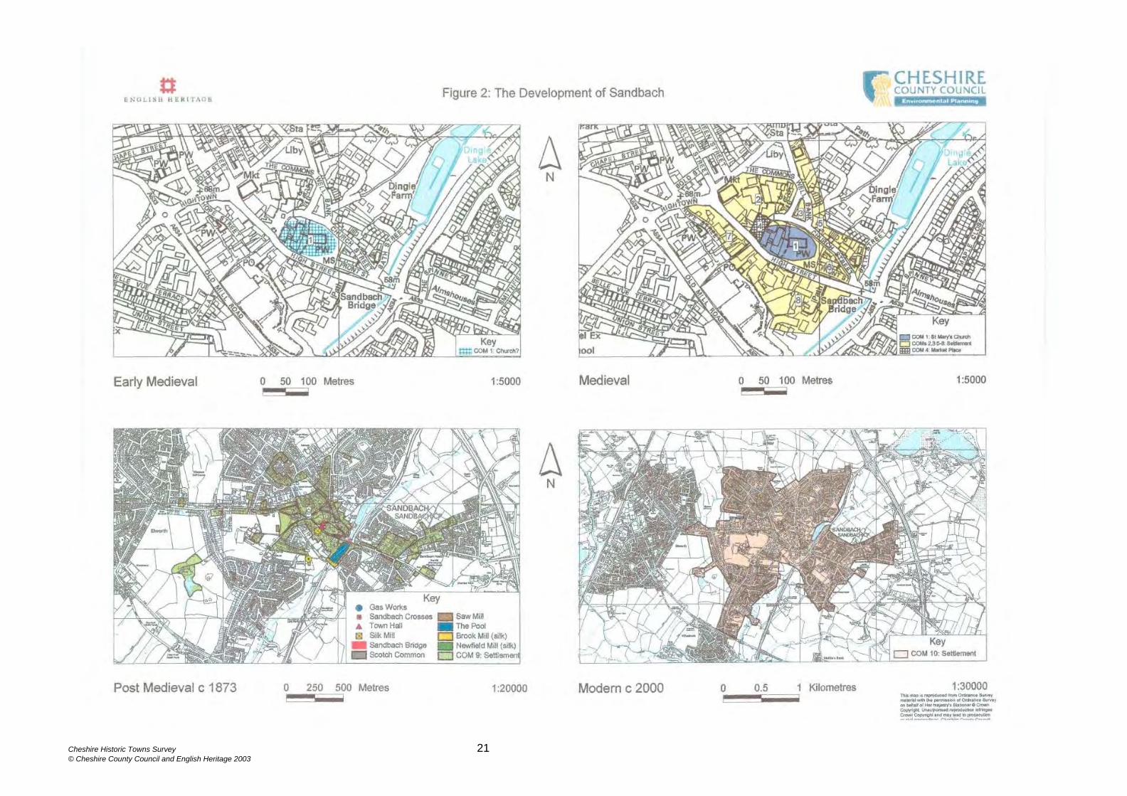
A number of 17th-century buildings, Listed Grade II survive in the surrounding area. These include Old Hall Farmhouse located 1.5km to the north of Sandbach at Brickhouses (CSMR 1308/0/1), Old House Farmhouse on Hassal Road 1km south-east (CSMR 1120/1), and the Fox Inn on London Road 2.5km to the north of Sandbach (CSMR 1310). 4. PLAN COMPONENTS The town has been divided into 10 components (prefixed by COM). These have been tentatively sub-divided by period, although there is a need for a great deal of further work to define the date of these plan components more closely. Many would have spanned more than one period but are discussed under their earliest likely date of occurrence. In some cases tightly defined plan components can be identified, in others only a general area can be delineated and these should be treated as a model against which future evidence should be tested. There is only very limited evidence of Roman activity at Sandbach, therefore the plan components commence with the early medieval period when an abundance of evidence suggests that there was a Minster church located on the site of the present St Mary’s Church. EARLY MEDIEVAL c540 –1066 (Figure 2: The Development of Sandbach) COM 1 - Minster Site MEDIEVAL c1066-1540 (Figure 2: The Development of Sandbach) COM 2 - Tenements south of The Commons COM 3 - Tenements west of Well Bank COM 4 - Market Place COM 5 - Tenements, east of Well Bank and Church Street COM 6 - Tenements, east of St Mary’s Church COM 7 - Tenements, west of High Street COM 8 - Tenements, south of High Street POST MEDIEVAL c 1873 (Figure 2: The Development of Sandbach) COM 9 - Settlement MODERN c 2000 (Figure 2: The Development of Sandbach) COM 10 - Settlement 4.1 Early Medieval (Figure 2) The available evidence suggests that there was a high status ecclesiastical centre at Sandbach, potentially even a Minster church, and this is most likely to have been located in St Mary’s churchyard. The former sub-circular outline of St Mary’s churchyard is still partially discernible on the tithe map of 1840 but it appears that the western boundary of the churchyard has been truncated by an area of later
Cheshire Historic Towns Survey 11 © Cheshire County Council and English Heritage 2003

development that has been inserted between the churchyard and the market place (COM 4). Whether this development also encroached upon the market place is unclear. The approximate extent of this circular area, which is typical of early medieval ecclesiastical foundations, is roughly identified as COM 1. It is not clear to what extent the churchyard extended to the west, therefore this component may include a greater area than that of the churchyard. The churchyard rises above the surrounding area, providing both a defensive location and an elevated status. No doubt there was settlement associated with this, but the location and extent of this remains to be discovered. 4.2 Medieval (Figure 2) It is not known to what extent there was continuity from the early medieval Minster to the medieval church, however COM 1 also identifies the area of the medieval church and churchyard, despite the fact that several hundred years may separate the two institutions. On the periphery of COM 1, particularly along the northern and southern boundaries, the tithe map of 1840 show houses clustered around edges of the churchyard. By the time of the OS First Edition of 1873, these buildings had been removed to make way for an expansion of the churchyard and the widening of the High Street and Church Street. This clustering of settlement around the churchyard, which is identified as part of COM 6, may have origins in the medieval period or earlier. There are few medieval references describing the urban characteristics of medieval Sandbach, which is quite surprising, as by the early 15th century the settlement was relatively prosperous. However, important information has been gleaned from the few archaeological excavations that have taken place in the town. An area of medieval settlement has been identified to the south of The Commons and to the north of the market place (COM 2). Although the layout of settlement in this area is not known, its close proximity to the High Street, market place and church suggest that it was a popular location for settlement. Medieval settlement has been identified in this area by archaeological excavation at the rear of the Crown Hotel. COM 3 is a triangular area, a shape often associated with medieval markets (Aston and Bond 1976, 88-9), and is similar in shape to Scotch Common, the site of the post medieval fairs. Although there is no supporting archaeological or historical evidence COM 3 may have been the site of a market or fair, probably in-filled during the medieval period. Archaeological excavations in the northern section of Hawk Street (COM 3) have revealed evidence of medieval occupation. The deposits were heavily truncated, which indicates that the area has been significantly remodelled during the post medieval and modern periods. Sandbach’s market charter was granted in 1578-9, however such charters were often a legitimisation of an earlier market (Miller and Hatcher 1995, 158-9), and this was probably true of Sandbach. The market place (COM 4) is adjacent to the High Street, the main east-west thoroughfare, yet none of the major roads of Sandbach runs directly into the market place. However, the in-filling that occurred to the west of the churchyard and east of the market place may have removed an important
Cheshire Historic Towns Survey 12 © Cheshire County Council and English Heritage 2003

route that ran through the market place and continued north. This is very much conjecture which will benefit from further work. While the market place may have been a later addition to the town plan, its location next to the church equally suggests that it may have an early origin. This is a common occurrence in medieval settlements and there are a number of examples of early medieval ‘minster markets’, where a market place is located by a gate of the minster enclosure (Hooke (ed) 1988, 35-58). The settlement component east of Well Bank and Church Street (COM 5) has irregular boundaries and comprises tenements in various forms. It appears to have developed organically, perhaps arising from squatter settlement rather than systematic planning. The northern boundary of COM 6 is defined by a road which was formerly called ‘Back Street’, which potentially indicates the rear boundary of a block of tenements. COM 6 is approximately 3m lower than St Mary’s churchyard, and it is therefore unlikely that the churchyard extended any further east. COM 7 represents the best preserved morphological evidence of medieval tenements in Sandbach. Property boundaries run at right angles to the High Street frontage, along which buildings are clustered. These boundaries, which appear to represent medieval tenements, are regularly laid out and bounded to the rear by a common boundary, three quarters of which is delineated by Hope Street, a partially surviving ‘back lane’. All of these characteristics indicate that this area of settlement was formally laid out. It is likely that COM 8 is a continuation of COM 7, particularly the northern area, which shares a partly surviving common rear boundary and tenement plots of similar length. Located to the south of this area is the Old Hall Hotel dated 1656, said to be the ‘ancient mansion’ of the lords of the manor (DoE 1978,13). At present there is no archaeological or historical evidence to suggest that this was the site of the medieval manor house. However, the Old Hall Hotel lies adjacent to the church, a common arrangement evident in a number of other medieval settlements (Platt 1981, 165; Taylor 1983, 132). How far medieval settlement extended southwards down High Street is not clear. The extent of the plan component may well prove to be exaggerated, however this remains to be tested in the future. 4.3 Post Medieval (Figure 2) The nature and extent of early post medieval Sandbach is unknown, but it is unlikely to have been of a greater size than the medieval town. However, expansion was stimulated by the establishment of a local industrial base (textiles, shoe making, salt making, chemicals and engineering). This in turn was encouraged by the cutting of the Trent and Mersey Canal, which passed through Elworth to the west and Wheelock to the south, and the construction of the Manchester to Crewe Railway to the west, which had a station at Elworth. Sandbach c 1873 is identified as COM 9. Here re-development is evident in the historic core, as well as in the expansion of the town’s periphery. Most development was undertaken to the west of Sandbach in Hightown, around Maltkiln Farm and to the north-west of Scotch Common. There
Cheshire Historic Towns Survey 13 © Cheshire County Council and English Heritage 2003

was also expansion along Crewe Road and Middlewich Road, and along Heath Road, Sandbach Heath. Hightown was an area of green field industrial and domestic development, including workers’ terraced houses, typical of the Victorian period. Houses belonging to the employees of the shoe industry were built fronting onto Scotch Common, and also located in this area was the Newfield Silk Mill. The earliest reference to Scotch Common dates from 1583, and later it provided the location for Sandbach’s two annual fairs. The common has a regular triangular shape formed by the converging Hightown and Well Bank Roads, suggesting that its establishment was the result of planning rather than organic growth. The Brook Silk Mill was built c1850 in the south-east area of the town. The silk industry was economically important to Sandbach, with Brook Mill ‘significant to the town’s development’ (Massey 1958, 12). The OS First Edition 6”: 1mile map (1873) shows that the works comprised two large linear factory buildings. Associated with, and to the north of, Brook Mill is a large rectangular area of water called ‘The Pool’. It is likely that ‘The Pool’ was originally a mill pond, supplying the large quantities of water used in the production of silk. The OS First Edition also shows a boat house to the west of the pool and tree lined walks, features which suggest that this was also used as a leisure area. This may have become redundant, after the opening of the Dingle Lake (to the north by Dingle Farmhouse) in the early 20th century. A school was recorded at Sandbach as early as 1579, but the present Grammar School was built in 1849-50 by the noted architect Sir George Gilbert Scott. To the east of the school there was a large saw mill, and just below this is an area of villas and terraced housing. At the end of one long terraced street called Union Street was the site of the Gas Works. Almshouses located on The Hill, to the east of Sandbach Bridge were designed by Sir George Gilbert Scott in 1865-7, and provided accommodation for twenty residents. They are Listed Grade II. Further east along The Hill is a large house called ‘The Hill’, built in 1733 and set within formal gardens. The date of the earliest occurring Sandbach Bridge is unknown, though it is likely that it was a post medieval construction replacing an earlier ford. Smithfield Lane runs in a northerly direction from The Hill, to the east of Sandbach Bridge. To the east of Smithfield Lane the OS First Edition map depicts six areas of regular, parallel and east-west aligned land parcels. The regularity of these areas suggests planning, although their precise function is unrecorded. Massey records that c 1850 a Mr Bull introduced the silk industry to Sandbach, by building a factory on Smithfield Lane, which was later converted into domestic dwellings called ‘Chimney Row’ (Massey 1958, 12). Although not part of the urban area of Sandbach, a reference dating from the 15th century records that a John Ford possessed an estate called Abbeyfields (Ormerod 1882, 100). The name suggests an association with a monastic house, presumably Dieulacres Abbey, who held the advowson and appropriation of Sandbach’s church.
Cheshire Historic Towns Survey 14 © Cheshire County Council and English Heritage 2003

Any relationships between Dieulacres and the large house (Abbeyfields) identified on the OS First Edition, to the south-west of the town, is unknown. 4.4 Modern (Figure 2) Modern development at Sandbach (COM 10) has significantly increased the extent of the town, and has linked the settlements of Sandbach, Elworth and Wheelock. At Sandbach and Wheelock development has generally been domestic, including large housing estates and their associated infrastructure: schools, leisure centres, parks, cemeteries etc. Elworth has undergone both domestic and industrial expansion, particularly to the west. 5 HISTORICAL & ARCHAEOLOGICAL POTENTIAL 5.1 Above-Ground Remains Much of Sandbach’s historic core is a designated Conservation Area and a large proportion of the town’s historic street pattern survives to the present day, particularly that of High Street. There are three Scheduled Ancient Monuments in Sandbach: the Sandbach Anglo-Saxon crosses (SAM 23637), the early medieval sculptural fragments in St Mary’s Church (SAM 30395) and the standing medieval cross 10m south of the nave of St Mary’s Church (SAM 30395). Sandbach contains 70 Listed Buildings, dating from the 16th century onwards and of particular interest. The Old Hall Hotel and the Sandbach Crosses are Listed Grade I and the Black Bear Inn Listed Grade II*. The remainder are Listed Grade II, including the 17th century Crown Hotel in the Market Place, 45 High Street (a late 16th-century/early 17th-century building), and 34 High Street, a restored 17th- century timber framed building. The Old Hall is dated 1656, it may have originally served as a manor house, but it has also been used as a parsonage, and in 1845 it was partially converted into an hotel (Tomlinson 1899, 38-9). Even older than the Old Hall is the Black Bear Inn, which is dated 1634. 5.2 Below-Ground Remains The limited amount of archaeological work that has been carried out in Sandbach means that the survival of archaeological deposits across the settlement cannot be properly assessed. However, the small scale work that has taken place to the rear of the Crown Hotel, where truncated medieval features and deposits were recovered, and on derelict land on the north-east side of Hawk Street, where evidence of 18th-century cottages and medieval occupation layers were revealed, has shown that archaeological deposits of good quality do survive and that there is the potential for survival of deposits in the rest of the settlement. 6 PRIORITIES FOR ARCHAEOLOGICAL WORK
Cheshire Historic Towns Survey 15 © Cheshire County Council and English Heritage 2003

6.1 General The study of Sandbach forms part of a national research priority to examine the origins and development of medieval small towns and rural markets (Priority H5; English Heritage 1997, 49). Work at Sandbach would fit into a number of these national priorities, particularly:
• PC6 Late Saxon to medieval • PC7 Transition from medieval to post medieval traditions (c1300-1700AD) 6.2 Early Medieval • Establish the nature and extent of settlement during the early medieval period. • Establish whether there was a Saxon Minster, examine the location, nature and
extent of this and its relationship to any contemporary settlement.
6.3 Medieval • Establish the precise location of settlement areas and date their phases of
expansion and contraction. • Establish the nature and extent of buildings on settlement plots. • Establish whether the Minster continued to be used in the medieval period. • Establish the date of foundation of the medieval church, examine phases of
expansion and contraction. • Examine evidence for medieval trade and industry. • Establish the foundation of the market place; were there other market areas, and
if so, where were these located? 6.4 Post medieval • Establish precise location of settlement areas and date the phases of expansion. • Examine evidence for post medieval trade and industry, establish to what extent
trade and industry encouraged the growth of the town and identify what form this expansion took.
7 SOURCES Bibliography Ashmore, O, 1982 The Industrial Archaeology of North-West England: and where to find it. Manchester University Press. Aston, M & Bond, J, 1976. The Landscape of Towns J M Dent Bagshaw, S, 1850 History, Gazetteer and Directory of the County Palatine of Chester Booth, P H W, 1985 The Cheshire Mize Book 1405 unpublished transcript Bott, O J P, 1985 Cornmill Sites in Cheshire 1066-1850 Cheshire History vols11-17
Cheshire Historic Towns Survey 16 © Cheshire County Council and English Heritage 2003

Calladine, A and Fricker, J, 1993 East Cheshire Textile Mills. Royal Commission on the Historical Monuments of England. Crosby, A, 1996. A History of Cheshire Phillimore CSMR, County Sites and Monuments Record, Environmental Planning, Cheshire County Council Earthworks Archaeological Services, 1999 An Archaeological Watching Brief :New Retail Development at the Commons, Sandbach unpublished report Earwaker J P, 1890 A History of the Ancient Parish of Sandbach County of Chester. Including the two Chapelries of Holmes Chapel and Goostrey. E.J. Morten. English Heritage, 1997 English Heritage Research Agenda, Draft 8 April 1997 Department of the Environment, 1978 List of Buildings of Special Architectural or Historic Interest: Borough of Congleton: Cheshire: Parish of Sandbach. Dodgson, J McN, 1970 The Place-Names of Cheshire: Part II The Place-Names of Bucklow Hundred and Northwich Hundred Cambridge University Press. Friar, S, 1991 The Batsford Companion to Local History Batsford. Furness, R R, 1978 Soils of Cheshire Soil Survey Bulletin No.6 Girouard, M, 1990 The English Town. Guild Publishing. Haines, B A and Horton, A, 1969 British Regional Geography: Central England 3rd edition Harris, B E and Thacker, A T (eds), 1987 The Victoria History of the County of Chester: Vol l Oxford University Press Harris, B E (ed), 1979 The Victoria History of the County of Chester: Vol II Oxford University Press Higham, N J, 1993 The Origins of Cheshire Manchester University Press Hindle, B P, 1990 Medieval Town Plans Shire Hooke, D (ed), 1988 Anglo-Saxon Settlements Blackwell. Kelly, 1892 Kelly’s Directory of Cheshire Kelly, 1914 Kelly’s Directory of Cheshire MacGregor, A J, 1992 The Alehouses and Alehouse Keepers of Cheshire 1629-1828 Massey, C, 1958 A History of Sandbach and District
Cheshire Historic Towns Survey 17 © Cheshire County Council and English Heritage 2003

Massey, C, 1967 A History of Sandbach and District Supplement Miller, E and Hatcher, J 1995 Medieval England: Towns, Commerce and Crafts 1086-1348. Longman. Morris and Company, 1874 Commercial Directory and Gazetteer of Cheshire Norris, J H, 1965 The Water Powered Corn Mills of Cheshire Transactions of the Lancashire and Cheshire Antiquarian Society 75-6 Ormerod, G, 1882 The History of the County Palatine and City of Chester 3 vols 2nd edition, edited by Thomas Helsby Pevsner, N, and Hubbard, E, 1971 The Buildings of England: Cheshire. Penguin Books Platt, C, 1981 The English Medieval Town. Paladin Platt, C, 1988 Medieval England: A Social History and Archaeology from the Conquest to 1600 AD Routledge Richards, R, 1973 Old Cheshire Churches Revised edition Royal Commission on the Historical Monuments of England, 1997 Excavation Index Records of Congleton Samuel, R, 1977 Miners, Quarrymen and Salt Workers Routledge. Sandbach District Urban Council, 1957 Sandbach Official Guide Smart, R, and Samuels, J, 1981a Excavations in Sandbach Cheshire 1981. Liverpool University Rescue Archaeology Unit unpublished report Smart, R, and Samuels, J, 1981b Excavations in Sandbach Cheshire 1981: Interim Report. Liverpool University Rescue Archaeology Unit unpublished report Taylor, C, 1983 Village and Farmstead: A History of Rural Settlement in England. Book Club Associates. Taylor, C, and Muir, R, 1983 Visions of the Past. Dent Tomlinson, R W, 1899 A History of Sandbach. Twigg, G D, 1994 Salt Working in Cheshire unpublished report University of Manchester, 1999 An Archaeological Assessment and Watching Brief: Land at Church Street/ Bath Street Sandbach, Cheshire unpublished report 7.2 Maps
Cheshire Historic Towns Survey 18 © Cheshire County Council and English Heritage 2003
(CRO – Cheshire Record Office) Burdett, P P, 1777, A Survey of the County Palatine of Chester (The Historic Society of Lancashire and Cheshire Occasional Series Volume 1 1974) Geological Survey of Great Britain, 1953: Macclesfield, solid edition, Sheet 110 surveyed 1906 Ordnance Survey First Edition 6”: 1 mile Sheet 50 Surveyed 1873 Saxton, C, 1577 Cestriae Comitatus (CRO PM 12/10) Speed, J, 1662 The County Palatine of Chester with the Most Ancient Citie Described (reprint of the 1610 original) (CRO PM1/11) Tithe Award, 1841 (Map: CRO EDT 351/2; Apportionment CRO EDT 351/1) ILLUSTRATIONS Figure 1: Sandbach and the Surrounding Area Figure 2: The Development of Sandbach
Cheshire Historic Towns Survey 19 © Cheshire County Council and English Heritage 2003

Cheshire Historic Towns Survey 20 © Cheshire County Council and English Heritage 2003
Cheshire Historic Towns Survey 21 © Cheshire County Council and English Heritage 2003