chestnut branch connector feasibility study
TRANSCRIPT
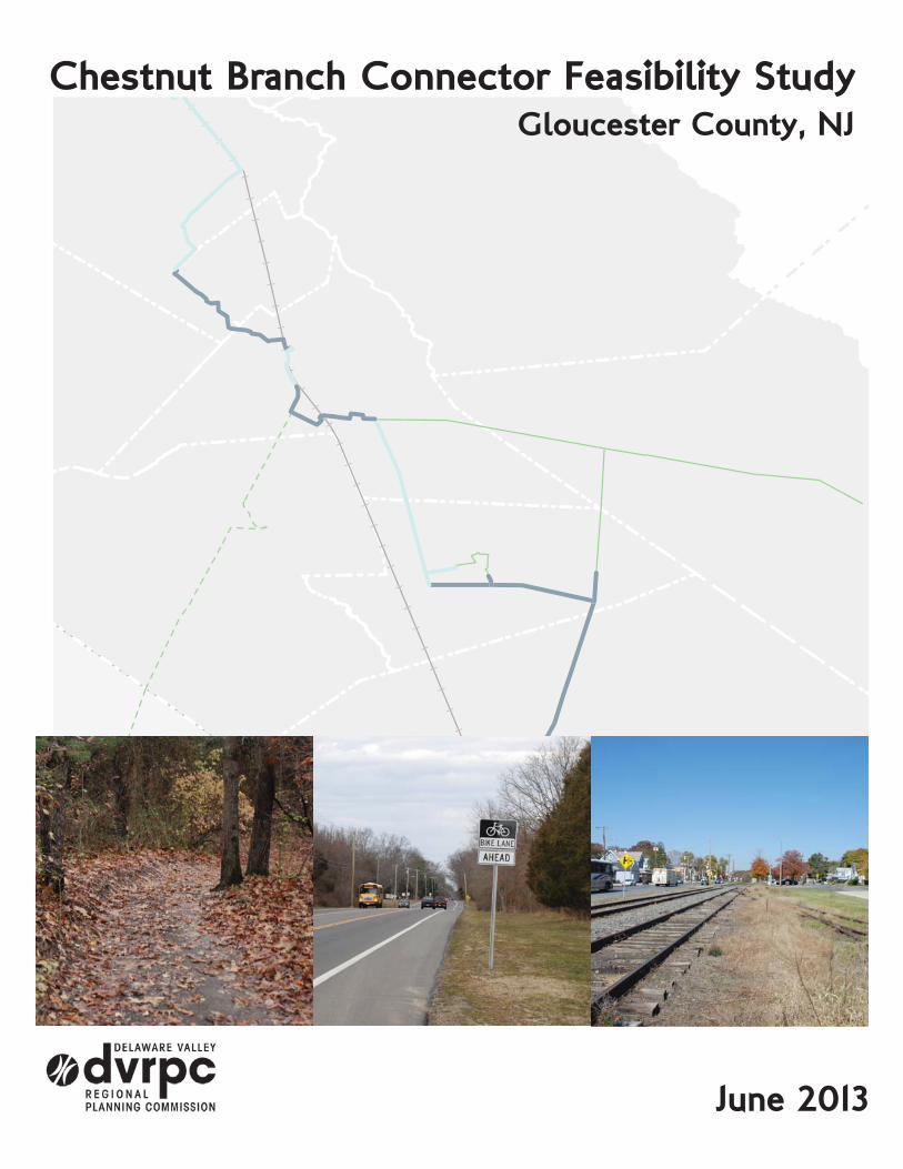
June 2013
Chestnut Branch Connector Feasibility StudyGloucester County, NJ

NNJNJ
PA
DE
New York City
Wilmington
Baltimore
MD
BURLINGTON
CHESTER
MERCER
BURLINGTON
CAMDEN
GLOUCESTER
DELAWARE
PHILADELPHIA
MONTGOMERY
CHESTER
BUCKS
The symbol in our logo is adapted from the
official DVRPC seal and is designed as a
stylized image of the Delaware Valley. The outer
ring symbolizes the region as a whole while the
diagonal bar signifies the Delaware River. The two adjoining crescents represent the
Commonwealth of Pennsylvania and the State of New Jersey.
DVRPC is funded by a variety of funding sources including federal grants from
the U.S. Department of Transportation’s Federal Highway Administration (FHWA) and
Federal Transit Administration (FTA), the Pennsylvania and New Jersey
departments of transportation, as well as by DVRPC’s state and local member govern-
ments. The authors, however, are solely responsible for the findings and conclusions
herein, which may not represent the official views or policies of the funding agencies.
DVRPC fully complies with Title VI of the Civil Rights Act of 1964 and related
statutes and regulations in all programs and activities. DVRPC’s website (www.dvrpc.org)
may be translated into multiple languages. Publications and other public documents can be
made available in alternative languages and formats, if requested. For more information,
please call (215) 238-2871.
The Delaware Valley Regional Planning
Commission is dedicated to uniting the
region’s elected officials, planning
professionals, and the public with a
common vision of making a great region
even greater. Shaping the way we live,
work, and play, DVRPC builds
consensus on improving transportation,
promoting smart growth, protecting the environment, and enhancing the economy. We
serve a diverse region of nine counties: Bucks, Chester, Delaware, Montgomery, and
Philadelphia in Pennsylvania; and Burlington, Camden, Gloucester, and Mercer in New
Jersey. DVRPC is the federally designated Metropolitan Planning Organization for the
Greater Philadelphia Region — leading the way to a better future.

i
Table of Contents
Introduction
Project Purpose
Report Structure
Segment Analyses
Segment 1: Mantua Portion
Mantua Portion Parcel Analysis
Mantua Portion Recommendations
Segment 2: Looney Trail
Looney Trail Parcel Analysis
Looney Trail Recommendations
Segment 3: Active Conrail Line I
Active Conrail Line I Parcel Analysis
Active Conrail Line I Recommendations
Segment 4: Glassboro Portion
Glassboro Portion Parcel Analysis
Glassboro Portion Recommendations
Segment 5: NJ 47 Connector
NJ 47 Connector Parcel Analysis
NJ 47 Connector Recommendations
Segment 6: On-Street Portion
On-Street Portion Parcel Analysis
On-Street Portion Recommendations
Segment 7: Active Conrail Line II
Active Conrail Line II Parcel Analysis
Active Conrail Line II Recommendations
Segment 8: Franklin Township and Newfield
Franklin Township and Newfield Parcel Analysis
Franklin Township and Newfield Recommendations
Summary
1
1
1
3
4
5
6
7
7
8
9
9
10
11
12
13
14
15
16
17
18
19
20
20
21
22
22
23
24

ii
Figures and Tables
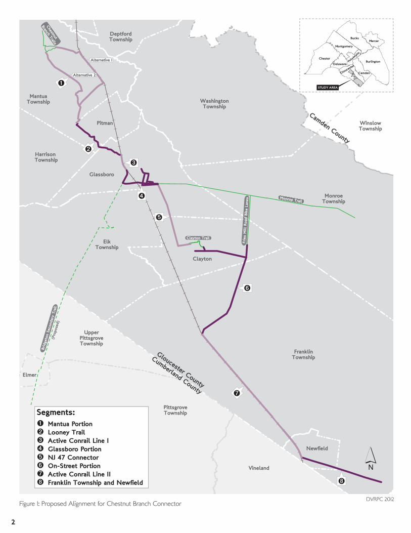
Figures Figure 1: Proposed Alignment for Chestnut Branch Connector
Figure 2: Mantua Portion Proposed Alignment and Existing Conditions
Figure 3: Mantua Portion Parcel Analysis
Figure 4: Mantua Portion Recommendations
Figure 5: Looney Trail Proposed Alignment and Existing Conditions
Figure 6: Looney Trail Parcel Analysis
Figure 7: Looney Trail Recommendations
Figure 8: Active Conrail Line I Proposed Alignment and Existing Conditions
Figure 9: Active Conrail Line I Parcel Analysis
Figure 10: Active Conrail Line I Recommendations
Figure 11: Glassboro Portion Proposed Alignment and Existing Conditions
Figure 12: Glassboro Portion Parcel Analysis
Figure 13: Glassboro Portion Recommendations
Figure 14: NJ 47 Connector Proposed Alignment and Existing Conditions
Figure 15: NJ 47 Connector Parcel Analysis
Figure 16: NJ 47 Connector Recommendations
Figure 17: On-Street Portion Proposed Alignment and Existing Conditions
Figure 18: On-Street Portion Parcel Analysis
Figure 19: On-Street Portion Recommendations
Figure 20: Active Conrail Line II Proposed Alignment and Existing Conditions
Figure 21: Active Conrail Line II Parcel Analysis
Figure 22: Active Conrail Line II Recommendations
Figure 23: Franklin Township and Newfield Proposed Alignment and Existing Conditions
Figure 24: Franklin Township and Newfield Parcel Analysis
Figure 25: Franklin Township and Newfield Recommendations
Figure 26: Recommended Alignment for the Chestnut Branch Connector
Tables Table 1: Segment Descriptions
2
4
5
6
7
8
8
9
10
10
11
12
13
14
15
16
17
18
19
20
21
21
22
23
23
25
1

1
Introduction
Project Purpose
Report Structure
This report includes a description of each segment that details points of interest and existing
conditions. A parcel analysis is included for each section, except for segments that are entirely
on-road. Road characteristics (AADTs and speed limits) are included for any portion where on-
road routing is proposed or recommended.
Segment Name From To
1
Mantua Portion Alternative 1via NJ 55 and Atlantic Ave.
Chestnut Branch Park
(Mantua)
Lambs Road
(Pitman)
Mantua Portion Alternative 2via Main St.
Chestnut Branch Park
(Mantua)
Lambs Road
(Pitman)
2 Looney TrailLambs Road
(Pitman)
Bowe Boulevard
(Glassboro)
3 Active Conrail Line IBowe Boulevard
(Glassboro)
Sewell and Ellis Roads
(Glassboro)
4 Glassboro PortionSewell and Ellis Roads
(Glassboro)
Monroe Trail and NJ 47
(Glassboro)
5 NJ 47 ConnectorMonroe Trail and NJ 47
(Glassboro)
Academy Street
(Clayton)
6 On-Street PortionAcademy Street
(Clayton)
Fries Mill Road and NJ 47
(Franklin)
7 Active Conrail Line IIFries Mill Road and NJ 47
(Franklin)
West Boulevard
(Newfield)
8 Franklin Township and NewfieldWest Boulevard
(Newfield)
Atlantic County line
(Franklin)
Because of the length of the proposed trail and the wide variation in its condition, it was
necessary to divide the alignment into segments. Table 1 lists each segment, its origin, and its
terminus. Each segment is displayed on the map on the following page (Figure 1).
The purpose of this project is to evaluate a proposed trail alignment, detailed in GIS files
provided by Gloucester County planning staff, spanning several municipalities in central and
southeastern Gloucester County. The alignment, referred to tentatively as the Chestnut Branch
Connector, would link parks and open space with existing and proposed trails (like the Monroe
Trail and Bridgeton Secondary). Towns such as Glassboro (and Rowan University’s campus)
and Pitman are also located along the trail alignment.
To determine the feasibility of this trail, DVRPC staff conducted several field visits to evaluate
the alignment, locate barriers to implementation, and determine alternatives, where appropriate.
To supplement these field views, staff examined parcel information to determine property
ownership, when relevant, and provided traffic counts to facilitate informed decision making.
Table 1: Segment Descriptions
DVRPC 2012
2
FranklinTownship
ElkTownship
MonroeTownship
PittsgroveTownship
WashingtonTownship
MantuaTownship
Clayton
Glassboro
Vineland
WinslowTownship
UpperPittsgroveTownship
Pitman
Harrison Township
Newfield
DeptfordTownship
Elmer
Monroe Trail
Brid
geto
n Se
cond
ary
Trai
l(P
ropo
sed)
Frie
s M
ill R
oad
Bike
Lan
es
Chestnut
Branch TrailsCumberland County
Gloucester County
Camden County
Mantua PortionLooney TrailActive Conrail Line IGlassboro PortionNJ 47 ConnectorOn-Street PortionActive Conrail Line IIFranklin Township and Newfield
Alternative 2
Alternative 1
Clayton Trail
Segments:
´Figure 1: Proposed Alignment for Chestnut Branch Connector
DVRPC 2012
Bucks
Montgomery
Chester
Delaware
Glouces
ter
Camden
BurlingtonPhila
delph
ia
Mercer
STUDY AREA

3
Segment AnalysesThis section describes each of the eight segments that comprise the proposed trail alignment.
Each analysis has three component parts:
1. Segment Description and Existing Conditions
The segment, its limits, and points of interest are described and presented in an
accompanying map. Pictures are included to illustrate current conditions.
2. Parcel Analysis
When appropriate, a parcel analysis was done to identify the parties whose
cooperation is necessary for implementation and to further illustrate possible barriers
to implementation. No parcel analysis was done for on-road segments.
3. Recommendations
Recommendations for problem areas and issues, as well as alternatives (when
necessary), are made.
4
Alternative 2
Alternative 1
MantuaTownship
Wenonah
55
Main St
Lam
bs R
d
Mantua B
lvd
Barnsboro Rd
Pitman Rd
Mount Royal Rd
Atlantic Ave
Tyler
s Mill
Rd
New
St
Laurel Dr
Map
le A
ve
Barlow AveTrenton Ave
Suss
ex A
ve
C
Ow
ens
Ln
Lestershire Dr
Rambo Dr
Sale
m A
ve
Mar
ylan
d A
ve
Esse
x A
ve
Livi
ngst
one
Rd
P
Indi
ana
Ave
e
Garfield Ave
Mantua BlvdWoodbury Glassboro Rd
Chestnut BranchPark Ceres
Park
SewellBaseballFields
Main St
Main St
´
0 0.3 0.60.15 Miles
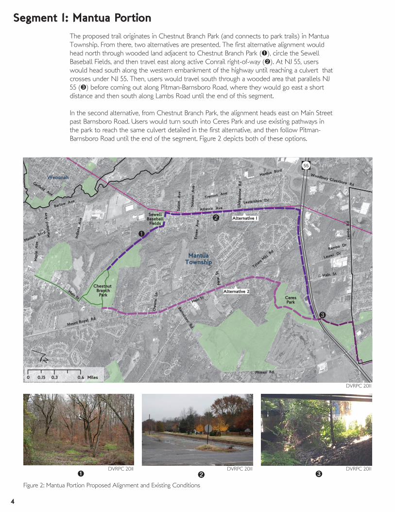
Segment 1: Mantua PortionThe proposed trail originates in Chestnut Branch Park (and connects to park trails) in Mantua
Township. From there, two alternatives are presented. The first alternative alignment would
head north through wooded land adjacent to Chestnut Branch Park (), circle the Sewell
Baseball Fields, and then travel east along active Conrail right-of-way (). At NJ 55, users
would head south along the western embankment of the highway until reaching a culvert that
crosses under NJ 55. Then, users would travel south through a wooded area that parallels NJ
55 () before coming out along Pitman-Barnsboro Road, where they would go east a short
distance and then south along Lambs Road until the end of this segment.
In the second alternative, from Chestnut Branch Park, the alignment heads east on Main Street
past Barnsboro Road. Users would turn south into Ceres Park and use existing pathways in
the park to reach the same culvert detailed in the first alternative, and then follow Pitman-
Barnsboro Road until the end of the segment. Figure 2 depicts both of these options.
DVRPC 2011 DVRPC 2011 DVRPC 2011
DVRPC 2011
Figure 2: Mantua Portion Proposed Alignment and Existing Conditions
5
MantuaTownship
Pitman
Wenonah
55
Main St
Lam
bs R
d
Mantua B
lvdBarnsboro Rd
Pitman Rd
M
Mount Royal Rd
Atlantic Ave
Tyler
s Mill
Rd
New
St
Rd
Laurel Dr
Map
le A
ve
Barlow AveTrenton Ave
Fairview Dr
Rambo Dr
Mantua Blvd
ChestnutBranch
Park
SewellBaseballFields
Cen
ter
St
Tylers Lake Rd
CeresPark
´
0 0.3 0.60.15 Miles
Alternative 2
Alternative 1
6,400(2008)
Parcel Ownership
Municipal
County
Conrail
County Road
State
Private Owner
Traffic Count (count year)
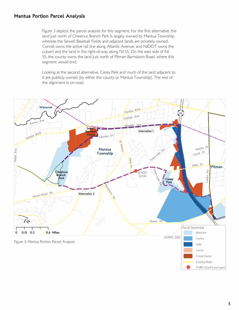
Figure 3 depicts the parcel analysis for this segment. For the first alternative, the
land just north of Chestnut Branch Park is largely owned by Mantua Township,
whereas the Sewell Baseball Fields and adjacent lands are privately owned.
Conrail owns the active rail line along Atlantic Avenue, and NJDOT owns the
culvert and the land in the right-of-way along NJ 55. On the east side of NJ
55, the county owns the land just north of Pitman-Barnsboro Road, where this
segment would end.
Looking at the second alternative, Ceres Park and much of the land adjacent to
it are publicly owned (by either the county or Mantua Township). The rest of
the alignment is on-road.
Figure 3: Mantua Portion Parcel Analysis
Mantua Portion Parcel Analysis
DVRPC 2012

6
Main St
Lam
bs R
d
Mantua Blvd
Barnsboro Rd
Pitman Rd
Mount Royal Rd
Atlantic Ave
Tyler
s Mill
Rd
New
St
Laurel Dr
Map
le A
ve
Cen
ter S
treet
Fairview Dr
Rambo Dr
Mar
ylan
d A
vee
E
Tylers Lake Rd
Main St
Main St
Mor
ris A
ve
MantuaTownship
Pitman
Wenonah
Chestnut BranchPark Ceres
Park
SewellBaseballFields
0 0.3 0.60.15 Miles
´
55
County Road
Proposed Alignment
Recommended Alignment
Issue Area
Existing Trail
Figure 4: Mantua Portion Recommendations
Mantua Portion Recommendations
Grade issues north of Chestnut Branch Park
Providing access to the trail along the active rail line east of Atlantic Avenue
Crossing issues at Tylers Mill Road and at Main Street
Remaining Issue Areas for Recommended Alignment:
There are complications with both alternatives. In regard to Alternative 1, grade issues are
present north of Chestnut Branch Park, and there may be issues with the rail right-of-way,
particularly when it separates from Atlantic Avenue east of East Morris Avenue. There are
crossing issues with any path that would run parallel to NJ 55 at Tylers Mill Road and Main
Street. Alternative 2 has potential issues with the narrow cartway of Main Street as well as
environmental issues in Ceres Park that make paving trails an unattractive option.
Staff recommends pursuing Alternative 1 because of the connections to the baseball fields in
Sewell as well as to the proposed Gloucester County Community College Connector Trail and
the potential siting of a future train station. Further, the majority of the alternative is off-road and
publicly owned.
DVRPC 2012
7
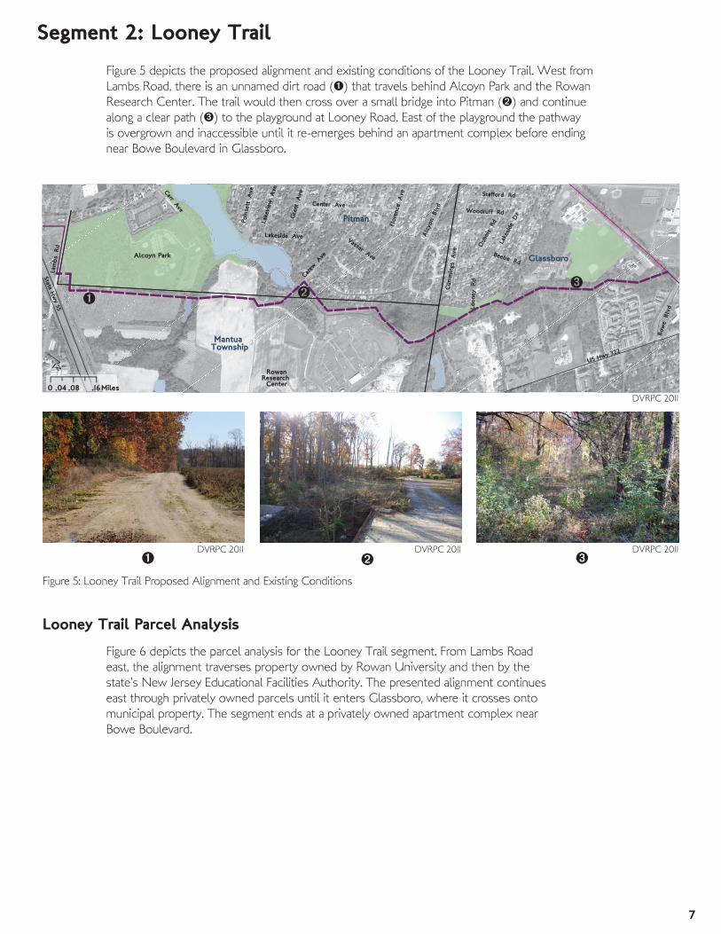
Figure 5 depicts the proposed alignment and existing conditions of the Looney Trail. West from
Lambs Road, there is an unnamed dirt road () that travels behind Alcoyn Park and the Rowan
Research Center. The trail would then cross over a small bridge into Pitman () and continue
along a clear path () to the playground at Looney Road. East of the playground the pathway
is overgrown and inaccessible until it re-emerges behind an apartment complex before ending
near Bowe Boulevard in Glassboro.
Alc
yon
Blv
d
Carew
Ave
Bow
e B
lvd
Flor
ence
A
ve
Carr Ave
Gra
nt A
ve
Lake
side
Dr
Lam
bs R
d
Center Ave
Cum
min
gs A
ve
Stafford Rd
Dub
ois
Rd
State Hw
y 55
Lake
view
Ave
Lakeside AvePo
inse
tt A
ve
Vassar Ave
Woodruff Rd
Loon
ey Rd
Beebe Rd
US Hwy 322
Pitman
Glassboro
Mantua Township
Alcoyn Park
RowanResearch Center
´0 .08 .16.04 Miles
Segment 2: Looney Trail
DVRPC 2011 DVRPC 2011 DVRPC 2011
DVRPC 2011
Figure 5: Looney Trail Proposed Alignment and Existing Conditions
Looney Trail Parcel Analysis
Figure 6 depicts the parcel analysis for the Looney Trail segment. From Lambs Road
east, the alignment traverses property owned by Rowan University and then by the
state’s New Jersey Educational Facilities Authority. The presented alignment continues
east through privately owned parcels until it enters Glassboro, where it crosses onto
municipal property. The segment ends at a privately owned apartment complex near
Bowe Boulevard.

8
US Hwy 322
State Hw
y 55
Lam
bs R
d
Alc
yon
Blv
d
Bow
e B
lvd
Carew
Ave
Flor
ence
A
ve
Carr Ave
Gra
nt A
ve
Rd
Lake
side
Dr
Center Ave
Swarthm
Cum
min
gs A
ve
Dub
ois
Rd
rvar
d R
d
Lake
view
Ave
Lakeside Ave Vassar Ave
C
Looney
Rd
Pitman
Glassboro
MantuaTownship
RowanResearch Center
Alcoyn Park
GlassboroHigh
School
0 .08 .16.04 Miles
´
Staff found this segment, as presented by the county, to be feasible. However, Figure 7
depicts two small deviations the recommended alignment makes from the proposed alignment.
These deviations would avoid several private properties and instead traverse land owned first
by Rowan University and then publicly. From Lambs Road until the playground at Looney
Road, the alignment would use an accessible, existing path. East of the playground, the path
is imperceptible through the dense growth. However, there is room for a multi-use trail, and
some flexibility may exist in planning the alignment because of the amount of publicly owned
land in this segment. Finally, the recommended alignment would connect to the Conrail tracks
farther north in order to stay on public land and to connect to the next segment.
A trail in this location would make a great local amenity. With potential connections to
Alcoyn Park, the Rowan Research Center, the playground at Looney Road, Glassboro High
School, and the neighborhoods surrounding Alcoyn Lake, it could be targeted for near-term
implementation.
Proposed Alignment
Recommended Alignment
Issue AreaFigure 7: Looney Trail Recommendations
Looney Trail Recommendations
Clearing and constructing a path through the overgrown area east of the
playground at Looney Road
Remaining Issue Areas for Recommended Alignment:
DVRPC 2012
US Hwy 322
Alc
yon
Blv
dCarew
Ave
Edsa
m A
ve
Bow
e B
lvd
Carr Ave
Gra
nt A
ve
p
Lake
side
DrLa
mbs
Rd
Center Ave
Cum
min
gs A
ve
Dub
ois
Rd
State Hw
y 55
Lake
view
Ave
Lakeside Ave Vassar Ave
Pitman
Glassboro
MantuaTownship
Alcoyn Park
RowanResearch Center
GlassboroHigh
School
´0 .08 .16.04 Miles
Parcel Ownership
Rowan University
Private Owner
Municipal
State
Utility
Figure 6: Looney Trail Parcel AnalysisDVRPC 2011
9
US Hwy 322
Girard Rd
Bow
e B
lvd
Whit
ney
Ave
Oakwood Ave
Swarth
more Rd
Beau Rivage Rd
Glassboro
´
0 0.1 0.20.05 Miles
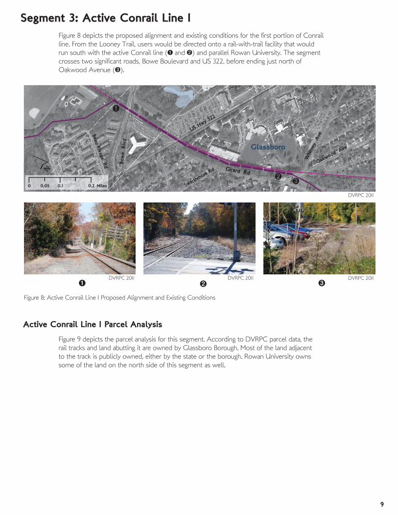
Segment 3: Active Conrail Line IFigure 8 depicts the proposed alignment and existing conditions for the first portion of Conrail
line. From the Looney Trail, users would be directed onto a rail-with-trail facility that would
run south with the active Conrail line ( and ) and parallel Rowan University. The segment
crosses two significant roads, Bowe Boulevard and US 322, before ending just north of
Oakwood Avenue ().
DVRPC 2011 DVRPC 2011 DVRPC 2011
DVRPC 2011
Figure 8: Active Conrail Line I Proposed Alignment and Existing Conditions
Figure 9 depicts the parcel analysis for this segment. According to DVRPC parcel data, the
rail tracks and land abutting it are owned by Glassboro Borough. Most of the land adjacent
to the track is publicly owned, either by the state or the borough. Rowan University owns
some of the land on the north side of this segment as well.
Active Conrail Line I Parcel Analysis

10
US Hwy 322
High St
Girard Rd
New St
Bow
e B
lvd W
hitne
y A
ve
Oakwood Ave
Hamilton R
d
Swarth
more Rd
Victoria
Beau Rivage Rd
Ruth Mancuso Ln
Glassboro
0 0.1 0.20.05 Miles
´
GlassboroHigh
School North Campus
Drive
The proposed alignment is feasible but challenging because the rail is active. Instead, staff
recommends crossing the railroad tracks at Ruth Mancuso Lane onto Glassboro High School
property and circling the perimeter of the school fields until reaching the intersection of Bowe
Boulevard and North Campus Drive. Currently, this intersection is unsignalized, but a signal
could be installed to create a safe crossing and regulate traffic. The alignment would cross
Bowe Boulevard into Rowan’s campus and turn south onto a service road that connects to a
university parking lot (although the lot is state owned, as indicated in the parcel analysis above).
Here, the alignment would continue south along the perimeter toward US 322. A ramp would
be required to bring the trail level with the road.
The alignment would cross over US 322 and the railroad tracks again and onto Girard Road,
where it would travel on-road until Oakwood Avenue.
Proposed Alignment
Recommended Alignment
Issue AreaFigure 10: Active Conrail Line I Recommendations
Active Conrail Line I Recommendations
Bringing the trail to the same grade as US 322 as it exits the Rowan parking
lot
Crossing US 322 due to traffic volumes and a lack of signalization
Remaining Issue Areas for Recommended Alignment:
DVRPC 2012
US Hwy 322
Girard Rd
St
New St
Bow
e B
lvd
Whit
ney
Ave
Oakwood Ave
Victoria
Ave
Beau Rivage Rd
North Campus
Drive
Ruth Mancuso Ln
Glassboro
GlassboroHigh
School
´
0 0.1 0.20.05 MilesParcel Ownership
Municipal
Conrail
Rowan University
State
Private Owner
Figure 9: Active Conrail Line I Parcel AnalysisDVRPC 2011
11
Mai
n S
t
High St
Ellis St
Monroe Trail
New St
Sewell StGirard Rd
Grove St
Wilmer St
State Hw
y 47
State St
Lake
St
Cou
nty
Hw
y 63
7
Uni
on S
t
Whitney Ave
Oakwood Ave
Buck
Rd
Church St
Prince
ton
Rd
Popl
ar S
t
Franklin Rd
Liberty St
Hol
ly S
tDickinson Rd
William
s St
Cornell Rd
University Blvd
Zane St
Victoria Ave
Georgetown Rd
Deptford Rd
Messina St
Falco
n Ave
War
rick
Ave
Aca
dem
y St
Owen Ave
e Rd
Glassboro Ave
College AveGifford St
East Blvd
Redmond Ave
New St
GlassboroSports
Complex
Rowan Blvd
GlassboroWasteFacility
Aca
dem
y St
Glassboro
ElkTownship0́ 0.1 0.20.05 Miles
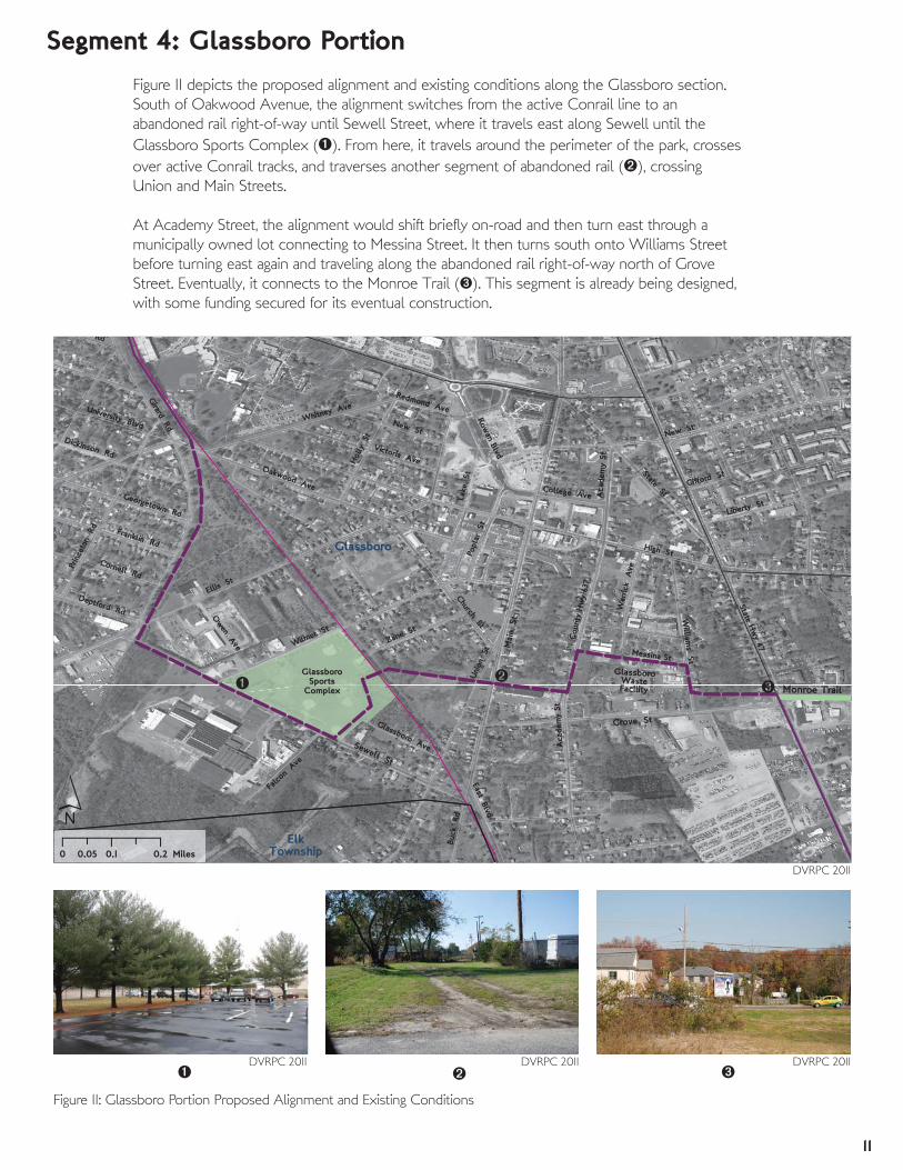
Segment 4: Glassboro PortionFigure 11 depicts the proposed alignment and existing conditions along the Glassboro section.
South of Oakwood Avenue, the alignment switches from the active Conrail line to an
abandoned rail right-of-way until Sewell Street, where it travels east along Sewell until the
Glassboro Sports Complex (). From here, it travels around the perimeter of the park, crosses
over active Conrail tracks, and traverses another segment of abandoned rail (), crossing
Union and Main Streets.
At Academy Street, the alignment would shift briefly on-road and then turn east through a
municipally owned lot connecting to Messina Street. It then turns south onto Williams Street
before turning east again and traveling along the abandoned rail right-of-way north of Grove
Street. Eventually, it connects to the Monroe Trail (). This segment is already being designed,
with some funding secured for its eventual construction.
DVRPC 2011 DVRPC 2011 DVRPC 2011
DVRPC 2011
Figure 11: Glassboro Portion Proposed Alignment and Existing Conditions
12
Mai
n S
tHigh St
Ellis St
New St
Sewell St
Girard Rd
Grove St
Wilmer St
State Hw
y 47
State St
Lake
St
Cou
nty
Hw
y 63
7
Uni
on S
t
Whitney Ave
Oakwood Ave
Buck
Rd
Church St
Princ
eton
Rd
Popl
ar S
t
Liberty St
Franklin Rd
Hol
ly S
t
William
s St
Mic
k A
ve
Cornell Rd
University Blvd
Victoria Ave
Georgetown Rd
Read
ing
St
Deptford Rd
Messina St
War
rick
Ave
Aca
dem
y S
t
College AveGifford St
East Blvd
New St
Rowan Blvd
Aca
dem
y St
Glassboro
Elk Township
GlassboroSports
Complex
GlassboroWasteFacility
0́ 0.1 0.20.05 Miles
Parcel Ownership
Conrail
Private Owner
County Road
Municipal
County
State
Utility
Rowan University
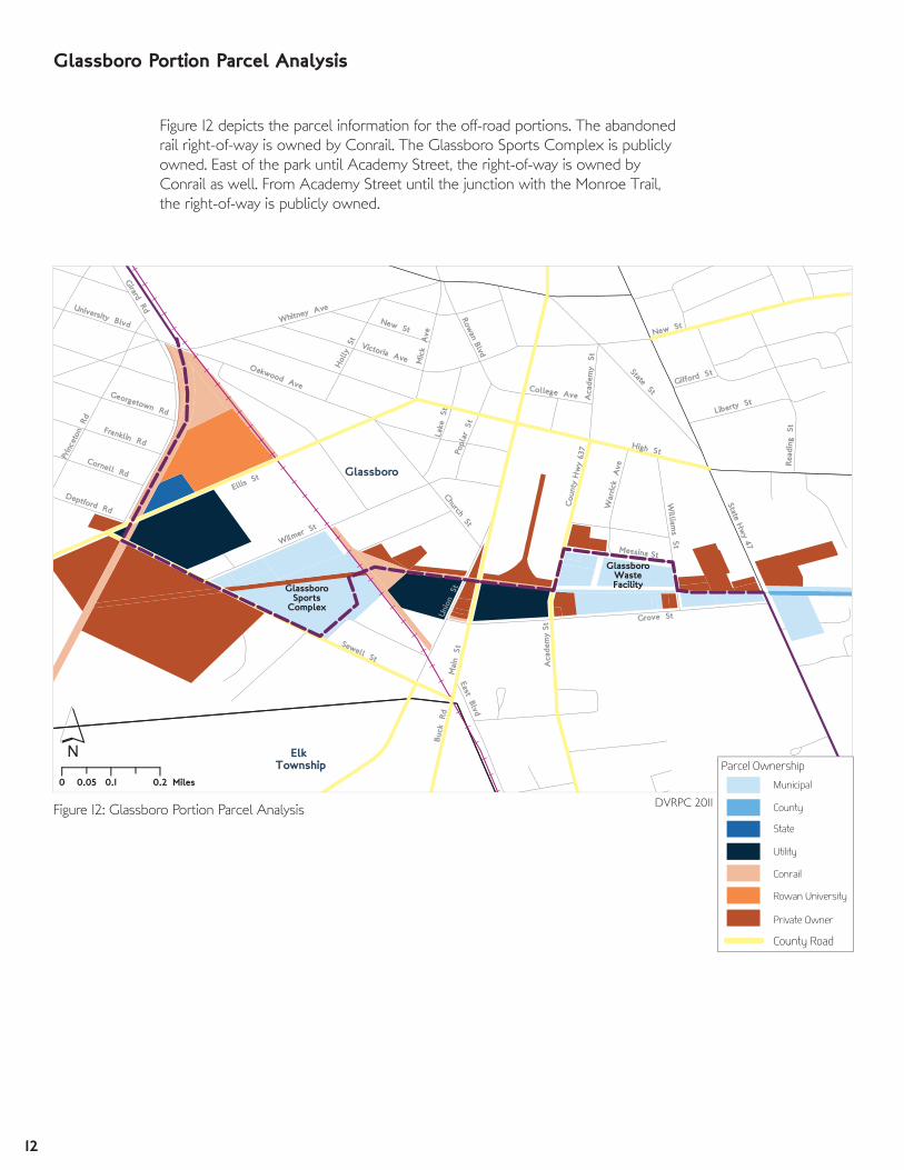
Figure 12 depicts the parcel information for the off-road portions. The abandoned
rail right-of-way is owned by Conrail. The Glassboro Sports Complex is publicly
owned. East of the park until Academy Street, the right-of-way is owned by
Conrail as well. From Academy Street until the junction with the Monroe Trail,
the right-of-way is publicly owned.
Figure 12: Glassboro Portion Parcel Analysis
Glassboro Portion Parcel Analysis
DVRPC 2011

13
Figure 13 depicts recommendations for this segment. As proposed by the county, this
segment’s alignment is feasible, but there are some significant issues. If the off-road option
is pursued, the abandoned rail right-of-way is wide enough for a multi-use trail, although an
arrangement with Conrail would be necessary, and significant work would have to be done
clearing the area. This old rail line continues south as the proposed Bridgeton Secondary Trail
that extends into Cumberland and Salem counties.
As in the previous section, an on-road alternative is proposed for short- to medium-term
implementation. Users can ride on Girard Street (continued from the previous segment) until
Ellis Street. From Ellis Street, it is a short distance until users would turn east onto Sewell
Street. From Sewell Street, the alignment recommended here is the same as the county’s
proposal. However, two issues would remain. The trail will cross the active Conrail right-of-way
just below Zane Street, a potentially dangerous situation for trail users. Also, the trail will cross
busy NJ 47. Warning signs at this location would be necessary.
Glassboro Portion Recommendations
Crossing active railroad tracks
Crossing NJ 47
Remaining Issue Areas for Recommended Alignment:
Mai
n S
t
High St
Ellis St
New St
Sewell St
Girard Rd
Grove St
Wilmer St
State Hw
y 47
State St
Lake
St
Cou
nty
Hw
y 63
7
Laurel St
Uni
on S
t
Whitney Ave
Oakwood Ave
Buck
Rd
Church St
Oak St
Princ
eton
Rd
Popl
ar S
t
Franklin Rd
Hol
ly S
t
William
s St
Cornell Rd
University Blvd
Mic
k A
ve
Zane St
Victoria Ave
Georgetown Rd
Villanova Rd
Deptford RdRe
adin
g S
t
Grillo Ave
War
rick
Ave
Aca
dem
y S
t
Owen Ave
Glassboro Ave
College Ave
East Blvd
New St
Glassboro
ElkTownship
GlassboroSports
Complex
GlassboroWasteFacility
0́ 0.1 0.20.05 Miles
County Road
Proposed Alignment
Recommended Alignment
Issue Area
Existing Trail
Figure 13: Glassboro Portion Recommendations
Z
DVRPC 2011

14
Clayton
Glassboro
Monroe Trail
47
£322
Academy St
Stanger Ave
Carpenters Ave
Center St
Howard Street
Gre
en St
Earl Ave
Atl
Clayton Aura Rd
Fairview Rd
Costill Ave
Truman Ave
8th Ave7th Ave
Wilson Ave
Euclid Ave
Buckboard Dr
Page Ave
Main St
Filbert St
Garw
ood Blvd
ClaytonHigh
School
Clayton Trail
´
AAt0 0.2 0.40.1 Miles
Segment 5: NJ 47 ConnectorFrom the intersection of the Monroe Trail and NJ 47, the alignment would continue south for
two and a half miles via bicycle lanes on NJ 47. The alignment turns left onto Howard Street
and then onto the Clayton Bike Path, which travels around the perimeter of Clayton High
School, through a wooded area, and behind a subdivision just north of Academy Street. This
segment would continue south onto Garwood Boulevard, either on- or off-road, until ending at
Academy Street.
DVRPC 2011
Figure 14: NJ 47 Connector Proposed Alignment and Existing Conditions

15
9,947 (2009)
Clayton
Glassboro
ElkTownship
MonroeTownship
Monroe Trail
47
Academy St
Stanger Ave
Carpenters Ave
Center St
Clinton St
Gre
en St
Earl Ave
Atlantic A
ve
Clayton Aura Rd
Fairview Rd
Costill Ave
Truman Ave
8th Ave7th Ave
Wilson Ave
Euclid Ave
Page Ave
WLinden St
Main St
Filbert St
Clayton Trail
ClaytonHigh
School
´0 0.2 0.40.1 Miles
13,450 (2010)
County Road
Traffic Count (count year)
Existing Trail
Much of the alignment in this segment is on-road. NJ 47 has an AADT of over 10,000 cars
per day and a speed limit of 50 miles per hour. The Clayton Bike Path is located on privately
owned land.
Figure 15: NJ 47 Connector Parcel Analysis
NJ 47 Connector Parcel Analysis
DVRPC 2012

16
Monroe Trail
Academy St
Stanger Ave
Carpenters Ave
Center St
Clinton St
Coyle Rd
Linden St
Earl Ave
Atlantic A
ve
Clayton Aura Rd
Carvin St
Costill Ave
Truman Ave
Filbert St
8th Ave7th Ave
Church Ln
Wilson Ave
Euclid Ave
Page Ave
Main St
Filbert St
Clayton Trail
Clayton
Glassboro
ip
MonroeTownship
´0 0.2 0.40.1 Miles
47
The alignment as depicted is feasible. NJ 47 has high traffic volumes and speeds, so bicycle
lanes should be buffered physically or with striping, and/or they should be sufficiently wide (7–8
feet or more) to provide additional separation between cyclists and vehicular traffic. Speed limits
should be lowered as well, if possible. Signage will be needed to direct people to the Clayton
Bike Path. Staff also recommends striping bicycle lanes on Academy Road the entire way to NJ
47 to increase the connectivity of the bicycle network and to provide a less circuitous option.
Figure 16: NJ 47 Connector Recommendations
NJ 47 Connector Recommendations
County Road
Proposed Alignment
Recommended Alignment
Issue Area
Existing Trail
DVRPC 2011
Creating a comfortable
environment for
bicyclists on NJ 47,
despite high speeds and
volumes.
Remaining Issue Areas for
Recommended Alignment:

17
Clayton Trail
Fries Mill Rd
Monroe Trail
State Hw
y 47
Academy St
Grant Ave
Coles Mill Rd
Willi
amsto
wn Rd
US Hwy 322
Stanger Ave
Clayton Ave
East
A
ve
Washington Ave
Carpenters Ave
Center St
Chestnut St
Jack
son
Ave
Hall Ave
Clinton St
Madison Ave
Carpenter Ave
Blackw
ood
Ave
Vin
e S
t
Gre
en St
Clearfield Ave
Arlington Dr
Clayton W
illiamstown Rd
Scotland Run Ave
Holly Rd
Stanger Ave
ScotlandRunPark
Frie
s M
ill R
d
Franklin Townshp
Clayton
MonroeTownship
Glassboro
0́ 0.5 10.25 Miles
Segment 6: On-Street Portion
From the NJ 47 Connector, users would travel east on Academy Street () to Fries Mill Road,
where they could continue east into Scotland Run Park (). Bicycle lanes would be striped
north on Fries Mill Road, connecting to existing lanes around Holly Road (). Bicycle lanes
would also be striped to the south until the junction of Fries Mill Road and Blackwood Avenue,
where they would continue on Blackwood Avenue, past the library, until NJ 47, where users
would then be directed off-road through a wooded area to an active Conrail right-of-way,
where this segment ends.
DVRPC 2011
DVRPC 2011
DVRPC 2011DVRPC 2011
Figure 17: On-Street Portion Proposed Alignment and Existing Conditions

18
Clayton Trail
Frie
s M
ill Rd
Monroe Trail
NJ 47
Academy St
Grant Ave
Coles Mill Rd
Willi
amsto
wn Rd
Stanger Ave
Clayton Ave
East
A
ve
Washington Ave
Carpenters Ave
Center St
High St
Chestnut St
Jack
son
Ave
Hall Ave
Clinton St
Madison Ave
Carpenter Ave
Blackw
ood
Ave
Gre
en St
Arlington Dr
Clayton William
stown Rd
Har
rison
A
ve
Scotland Run Ave
Holly Rd
Stanger Ave
Frie
s M
ill R
d
FranklinTownship
Clayton
MonroeTownship
Glassboro
5,912 (2009)
1,200 (2010)
4,365 (2008)
4,537 (2009)
5,695 (2009)
8,906 (2008)
ScotlandRunPark
NJ 47
NJ 55
CR 610
0́ 0.5 10.25 Miles
The properties just north of the Conrail right-of-way are all privately owned, as depicted on
Figure 18. The rest of this segment is on-road, so no parcel analysis is necessary. Instead, traffic
volumes along Fries Mill Road, Blackwood Avenue, and Academy Street are shown. Both
Blackwood Avenue and Fries Mill Road are county roads.
Parcel Ownership
Conrail
Private Owner
County Road
Traffic Count (count year)
Figure 18: On-Street Portion Parcel Analysis
On-Street Portion Parcel Analysis
DVRPC 2012

19
Frie
s M
ill Rd
State Hw
y 47
Academy St
Grant Ave
Willi
amsto
wn Rd
Monroe Trail
Coles Mill Rd
Stanger Ave
Clayton Ave
East
A
ve
Washington Ave
Royal Ave
Carpenters Ave
Swedesboro Rd
Pennsy
lvania
Ave
Willow
Grove Rd
Chestnut St
Jack
son
Ave
Porchtown R
d
US Hwy 322
Hall Ave
Madison Ave
Fairview Rd
Clayton Aura Rd
Whitney Ave
Blackw
ood
Ave
Reed Ave
Green St
Clayton Williamstown
Rd
Arlington Dr
Scotland Run Ave
Borough Ave
Jack
son
Ave
Stanger Ave
Cenco Blvd
DelseaRegional
High School
Frie
s M
ill R
d
FranklinTownship
Clayton
Glassboro
MonroeTownship
ElkTownship
ScotlandRunPark
0 0.5 10.25 Miles
´
Clayton Trail
The on-road facilities proposed by the county are feasible. To enhance access to the new
facilities along NJ 47 (Segment 4), bicycle lanes should be striped on Academy Street (AADT
5,900) all the way to NJ 47. In addition to using Blackwood Avenue, Fries Mill Road south of
the Blackwood intersection should be striped with bicycle lanes to provide access to Delsea
Regional High School.
To further enhance bicycling along Fries Mill Road, the speed limit (currently 50 miles per
hour) should be lowered and a buffer should be painted onto the road between bicycle lanes
and traffic lanes, creating additional separation between cyclists and vehicular traffic.
County Road
Proposed Alignment
Recommended Alignment
Issue Area
Existing Trail
Figure 19: On-Street Portion Recommendations
On-Street Portion Recommendations
DVRPC 2012
Remaining Issue Areas for
Recommended Alignment:
Lower speed limit
and paint buffer along
bicycle lanes on
Fries Mill Road and
Blackwood Avenue
to enhance safety and
comfort for cyclists.
20
FranklinTownship
CumberlandCounty
NewfieldUS H
wy 40
State Hwy 47 West Blvd
Oak Ave
Dut
ch M
ill R
d
Porchtown Rd
Fries Mill Rd
M
Gru
bb Rd
Blac
kwoo
d A
Pear
l St
Leon
ard
Cak
e R
d Malaga Lake Drive
Church StNel
son
Ave
Elm
er S
t
Main St
St
Old
Mar
shal
l M
ill Rd
Wal
l S
t
Sale
m A
ve
MalagaLake
´
St
0 0.5 10.25 Miles
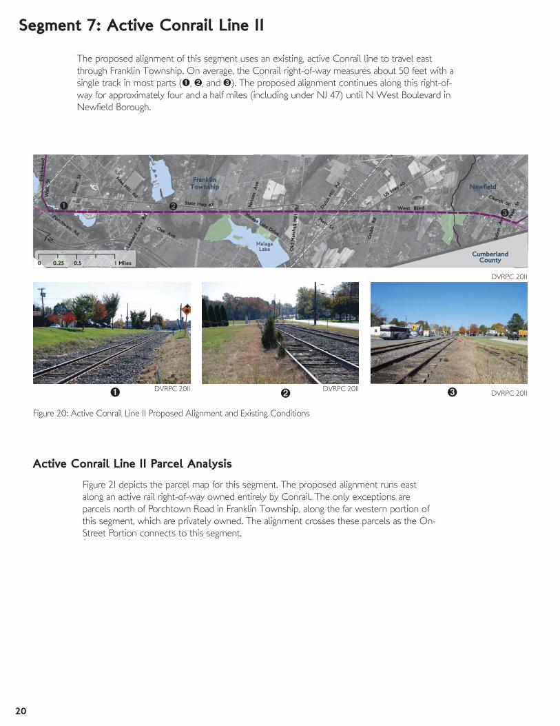
Segment 7: Active Conrail Line II
The proposed alignment of this segment uses an existing, active Conrail line to travel east
through Franklin Township. On average, the Conrail right-of-way measures about 50 feet with a
single track in most parts (, , and ). The proposed alignment continues along this right-of-
way for approximately four and a half miles (including under NJ 47) until N West Boulevard in
Newfield Borough.
DVRPC 2011 DVRPC 2011DVRPC 2011
DVRPC 2011
Figure 20: Active Conrail Line II Proposed Alignment and Existing Conditions
Figure 21 depicts the parcel map for this segment. The proposed alignment runs east
along an active rail right-of-way owned entirely by Conrail. The only exceptions are
parcels north of Porchtown Road in Franklin Township, along the far western portion of
this segment, which are privately owned. The alignment crosses these parcels as the On-
Street Portion connects to this segment.
Active Conrail Line II Parcel Analysis

21
FranklinTownship
Newfield
Vineland
US Hwy 4
0
State Hwy 47 N West Blvd
Lake
Rd
Oak Ave
Dut
ch M
ill R
d
Porchtown Rd
Fries Mill Rd
Morris
Ave
Gru
bb Rd
Blac
kwoo
d A
ve
Col
umbi
aAve
Leon
ard
Cak
e R
d
Malaga Lake Drive
Not
hnick
Ln
Nel
son
Ave
Old
Mar
shal
l M
ill Rd
Sale
m A
ve
MalagaLake
´́
0 0.5 10.25 Miles
While the right-of-way is overgrown and difficult to access at points, the proposed
alignment is feasible (pertaining to infrastructure or available space). Additionally, some
segments of the Conrail property run through publicly owned lands, giving some flexibility in
the design of the trail alignment. The parcels north of Porchtown Road are privately owned,
but the land is wooded, and there is room to build a short off-road segment without impacting
existing structures or yards.
If rail-with-trail is impermissible, staff has recommended an on-road alternative. From
Fries Mill Road (in Segment 6), bicycle lanes can be striped along NJ 47 for almost three miles.
It would then continue south on NJ 47/NJ 40 briefly before turning onto N West Boulevard,
which becomes County Road 615.
While only County Road 615/West Boulevard south of Columbia Avenue is currently wide
enough for bicycle lanes (north of Columbia, the shoulders are six feet or less, and there is
only one lane in each direction), parcel records indicate that there is extra space within the
existing right-of-way to add bicycle lanes to remaining sections of County Road 615 and US 40
without having to acquire additional right-of-way.
County Road
Proposed Alignment
Recommended Alignment
Area of IssueFigure 22: Active Conrail Line II Recommendations
Active Conrail Line II Recommendations
Pedestrians currently use the shoulders to travel along the corridor. If bicycle
lanes were striped onto the road, pedestrians would have to find, or be
provided with, alternative accommodations.
The intersection of NJ 47 and NJ 40 is challenging. Speed is a concern, and
directional signage for trail users would be very important.
Remaining Issue Areas for Recommended Alignment:
DVRPC 2012
Franklin Township
CumberlandCounty
NewfieldUS Hwy 4
0
State Hwy 47 N West Blvd
Penn
sylv
ania A
ve
Oak Ave
Dut
ch M
ill R
d
Porchtown Rd
Fries Mill Rd
Gru
bb Rd
Helena
St
Catawba
A
Har
ris A
ve
Col
umbi
aAve
Leon
ard
Cak
e R
d
County Hwy 615
Not
hnick
Ln
Roos
evel
t A
ve
Church StNel
son
Ave
Elm
er S
t
Old
Mar
shal
l M
ill R
d
´́
0 0.5 10.25 Miles
Parcel Ownership
Municipal
County
Conrail
Private Owner
County Road
UtilityFigure 21: Active Conrail Line II Parcel Analysis
DVRPC 2011

22
Main Rd
Weymouth Rd
Blue
Bel
l Rd
Strawberry Ave
Gorgo LnPea
rl St
Rena St
Forest Grove Rd
Arch St
West Blvd
Mulberry
Forsythia Dr
Hazel Ave
Franklin Township
CumberlandCounty
Newfield
´0 0.25 0.50.125 Miles
Segment 8: Franklin Township and Newfield
DVRPC 2011DVRPC 2011DVRPC 2011
DVRPC 2011
Figure 23: Franklin Township and Newfield Proposed Alignment and Existing Conditions
Franklin Township and Newfield Parcel Analysis
Figure 23 depicts the proposed alignment of this segment and photographs of existing
conditions. From the active Conrail right-of-way at Rena Street (Segment 7), the alignment
continues along an abandoned, overgrown rail right-of-way headed east (). At Gorgo Lane,
there are large piles of dirt and debris in the right-of-way (). The alignment continues past
Forsythia Drive and over Weymouth Road. From here to Main Road, the alignment is clear
and open (), although there is some evidence it is used by adjacent property owners. Once
over Main Road, a driveway appears to have been built in the right-of-way, blocking access and
further exploration between Main Road and Blue Bell Road.
East of Blue Bell Road, the alignment is impassible and difficult to find through trees and brush.
Aerial imagery indicates that several buildings have been built in the alignment as well as
several driveways.
As depicted in Figure 24, the majority of parcels in this segment are in private
ownership, and some structures have been built in what was previously the rail
right-of-way. A small parcel on Weymouth Road is owned by the South Jersey Gas
Company. Newfield Borough owns several lots near Gorgo Lane.

23
Main Rd
Weymouth Rd
Blue
Bel
l Rd
Rd
Strawberry Ave
Mad
ison
A
ve
Gorgo LnPea
rl St
Rena St
Forest Grove Rd
Arch St
West Blvd
Forsythia Dr
Franklin Township
CumberlandCounty
Newfield
´Miles0 0.25 0.50.125
Despite property ownership issues, the proposed alignment is largely feasible. At
Forsythia Drive, users would have to be directed on-road for a quarter of a mile along
Weymouth Road because of structures in the proposed alignment. Some rerouting may have
to be done around Gorgo Lane, depending on Newfield Borough’s plans for those properties.
East of Blue Bell Road, the alignment is undetectable through the woods, but aerial imagery
indicates that homes and driveways have been built in the right-of-way, so some rerouting will
have to be done to avoid these structures. These deviations can be seen in Figure 25.
It should be noted that across the Atlantic County line, a trail runs along this same right-of-way.
However, as that trail approaches the Gloucester County line, it is diverted south. Connecting
to this trail would link trail users into downtown Buena, Atlantic County, and the feasibility of
such a connection should be studied.
Proposed Alignment
Recommended Alignment
Issue AreaFigure 25: Franklin Township and Newfield Recommendations
Franklin Township and Newfield Recommendations
Rerouting may be necessary at Gorgo Lane, depending on future
development plans
Alignment would have to shift on-road at Weymouth Road because of
structures in the path of the proposed alignment
Private structures have encroached on proposed alignment
Remaining Issue Areas for Recommended Alignment:
DVRPC 2011
Main Rd
Weymouth Rd
Blue
Bel
l Rd
Flora RdStrawberry Ave
Mad
ison
A
ve Gorgo Ln
Pearl S
t
Forest Grove Rd
Rena St
West Blvd
Arch St
Mulberry
Forsythia Dr
R
Forest Grove R
d
Franklin Township
CumberlandCounty
Newfield
´0 0.25 0.50.125 Miles
Parcel Ownership
Municipal
Utility
Conrail
Private Owner
Figure 24: Franklin Township and Newfield Parcel AnalysisDVRPC 2011

24
Summary
Some segments, while feasible, may be more complicated. Any trail proposed to run alongside
active rail right-of-way would require negotiations with the owner to allay safety concerns.
There is no single accepted standard for designing these types of trails, although it is accepted
that there must be at least 10 feet between the center of the tracks and the trail. All of the
segments that run alongside the active Conrail line meet this requirement, but there may be
other concerns that arise.
A map of the recommended segments is shown in Figure 26. Many of the recommended
segments coincide with the proposed alignment, demonstrating that much of what is proposed
by the county is feasible. In particular, the following segments represent significant opportunities
to improve access and could be short-term priorities.
The Looney Trail (Segment 2)
The Looney Trail would extend from Lambs Road in Mantua Township to
Rowan’s campus at Bowe Boulevard. It could provide access to the campus
of Rowan University, Rowan Research Center, as well as to residents on the
north side of the proposed alignment. Much of the trail could be built on
publicly owned land, and there is some flexibility in its routing.
Extension of Monroe Trail through Glassboro (Segment 4)
Extending the Monroe Trail west from its current terminus at NJ 47 would
improve access into Glassboro as well as create a link to the planned
Bridgeton Secondary Trail, which will extend south to Salem County. Providing
on-road facilities from the trail to Rowan’s campus and downtown Glassboro,
would further enhance these connections.

25
FranklinTownship
ElkTownship
MonroeTownship
PITTSGROVE
WashingtonTownship
MantuaTownship
Clayton
Glassboro
Vineland
GloucesterTownship
WinslowTownship
Upper PittsgroveTownship
Pitman
HarrisonTownship
Newfield
DeptfordTownship
Elmer
Monroe Trail
Brid
geto
n Se
cond
ary
Trai
l(P
ropo
sed)
Clayton Trail
Mantua PortionLooney TrailActive Conrail Line IGlassboro PortionNJ 47 ConnectorOn-Street PortionActive Conrail Line IIFranklin Township and Newfield
Frie
s M
ill R
oad
Bike
Lan
es
Chestnut
Branch Trails
Segments:
Cumberland County
Gloucester County
Camden County
´Figure 26: Recommended Alignment for the Chestnut Branch Connector
DVRPC 2012


Publication Title:
Publication Number:
Date Published:
Geographic Area Covered:
Chestnut Branch Connector Feasibility Study, Gloucester County, NJ
12022
June 2013
New Jersey, Gloucester County, Clayton, Franklin Township, Glassboro, Mantua
Township, Newfield, Pitman
Key Words: Multi-use trails, feasibility studies, bicycles, pedestrians, bicycle facilities
Abstract: This project evaluates the viability of a multi-use trail spanning several municipalities in Gloucester
County, New Jersey. Staff conducted fieldwork and analyzed parcel data throughout the study area to determine
the trail’s feasibility. Where on-road bicycle facilities are considered, traffic speeds and volumes were consulted.
Alternatives are recommended when a particular segment of trail is determined to be infeasible or challenging.
Staff Contacts:
Cassidy Boulan
Transportation Planner
215.238.2832