chorley park trail connection accessibility - january 21, 2015
TRANSCRIPT

1
Parks Forestry & Recreation, Toronto & Region Conservation Authority, Transportation, Public Consultation Unit
Chorley Park Trail Connection Accessibility

Meeting Agenda
6:30 Orientation: confirm accommodations, logistics and agenda
6:45 Presentation: Chorley Park Hillside in Context(Wendy Strickland, City of Toronto)
7:00 Questions & Answers about Chorley Park Hillside in Context
7:15 Presentation: Latest Trail Concept from November 2014 (RV Anderson)
7:30 Questions & Answers about Trail Concept
7:45 BREAK
8:00 Discussion: Recommendations on Trail Design
8:50 Wrap-up and Next Steps
9:00 Adjourn
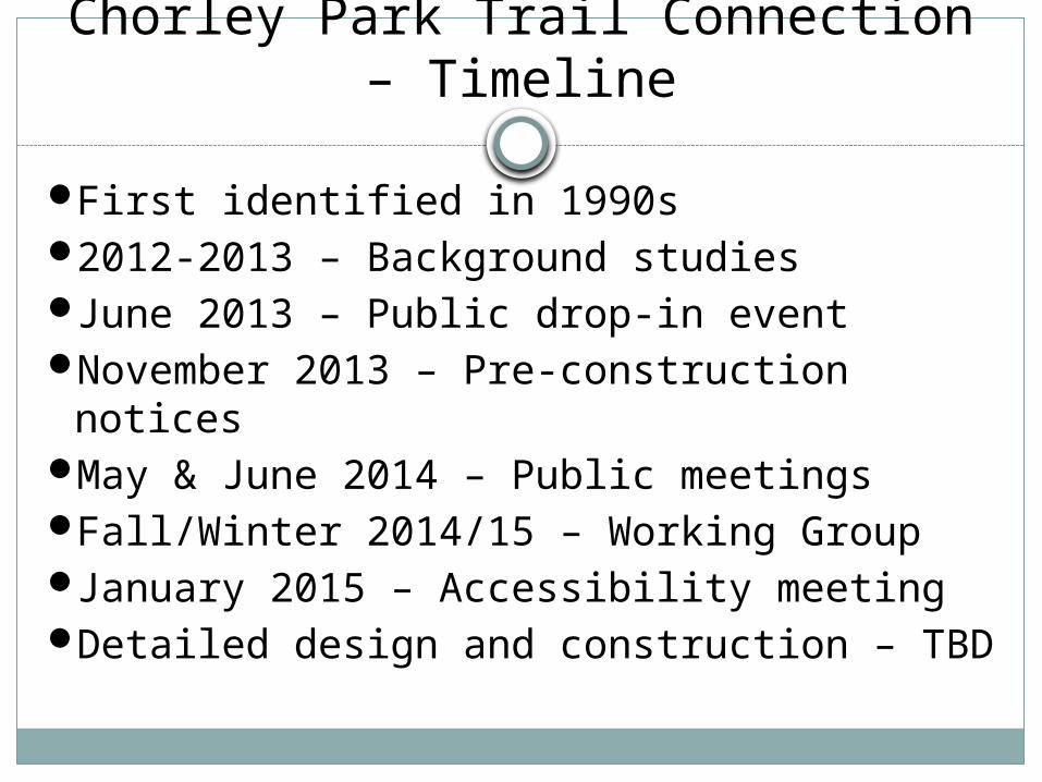
Chorley Park Trail Connection – Timeline
First identified in 1990s2012-2013 – Background studiesJune 2013 – Public drop-in eventNovember 2013 – Pre-construction noticesMay & June 2014 – Public meetingsFall/Winter 2014/15 – Working GroupJanuary 2015 – Accessibility meetingDetailed design and construction – TBD

Chorley Park
Chorley Park is located in Rosedale – Moore Park (Ward 27).

Chorley Park - History
The location of Ontario’s last Government House.
The site was developed into a park in the 1960s.

Chorley Park

Chorley Park – Tableland section

Chorley Park

Chorley Park – Ravine edge

Chorley Park – Tree Removals

Chorley Park – Ravine Slope

Connection to the Beltline Trail

Connection to the Brick Works

Chorley Park – Existing Trails
Chorley Park
Bel
tlin
e Tr
ail
Staircase
Paved Trail
Dirt Trail

Chorley Park – Existing Trails

Chorley Park – Existing Trails

Chorley Park – Existing Trails

Objectives for the Chorley Park Trail
Numerous existing trails are causing damage to the environment
Concentrate users on a formal trail to keep vegetation from being trampled

Objectives for the Chorley Park Trail
Provide a safe connection to the Beltline Trail, Moore Park Ravine, and the Don Valley Brickworks Park
Replace existing rotting wooden stairs, asphalt and dirt paths

Objectives for the Chorley Park Trail
Provide a surface treatment that allows access for a variety of users and reduces annual maintenance costs

Protect the butternut trees, as legislated under Ontario’s Endangered Species Act
Replant the slope to replace invasive species with a healthy, diverse native forest
Objectives for the Chorley Park Trail

Minimize the number of trees impacted and prioritize the preservation of large, healthy native trees.
Objectives for the Chorley Park Trail

Objectives for the Chorley Park Trail
Maintain or improve the stability of the slope
Address the effects of erosion from existing dirt trails on the slope

Objectives for the Chorley Park Trail
Build a trail that will be durable and long lasting to reduce ecological disturbance and cost associated with frequent replacement
Asphalt trail in East Don Parkland with minor repairs to date

Questions on Chorley Park Context?
25

Revised Trail Plan (November 2014)

Revised Trail Plan (November 2014)
Total Trail Connection Length* 377 m
Trail Slope* 6.8% average 8.0% max
Trail Width 2.2 m
Trail Surface Asphalt
Trail Shoulders 0.3-1.0 m wide with granular surface
Fencing and Railing Required where drop of >1 m
Landings/Rest Areas Five 3 m long flat landings
Retaining Walls And Grading 1-3 stones high along 30% of trail
Hillside Rise* 26 m
Hillside Run* 90 m
* values are approximate

Revised Trail Plan (November 2014)
Most lengths

Revised Trail Plan (November 2014)
Where retaining walls less than 1m are necessary

Revised Trail Plan (November 2014)
Where retaining walls greater than 1m are necessary

Revised Trail Plan (November 2014)
Resting areas ("bump outs")

Questions?
32

Closure of Informal Trails
Don Valley Brick Works Park,trail closure due to severe erosion, 2014

Why not use gravel?
Milkman’s Lane, Summer 2013

Why asphalt?
Asphalt is a stable and firm surface that has some flexibility before cracking
Many of the existing trails on Chorley slope are constructed of asphalt
Asphalt provides a layer of protection and reduce the impact of foot traffic on soils and tree roots