christine wiedinmyer - university corporation for ... · finnv2: updates in progress •comparing...
TRANSCRIPT

Fire datasets, emissions, forecasting, land coverChristine Wiedinmyer

Overview
• Emissions from Fires• Available inventories
• Creating your own emissions• Input datasets
• Fire Forecasting• What’s available online data
• What else are you looking for?

Estimating emissions from open burning
• Fire-Specific Estimates• Biscuit Fire (Campbell et al., 2007)• Black Saturday Fires Australia (Murphy et al., 2012)
• Regional Models• FLAMBE (Reid et al., 2008)• North America (Wiedinmyer et al., AE, 2006)• Himalaya (Vadrevu et al., AE, 2011)• Western U.S. (Urbanski, ACP, 2012)• Asia (Song et al., ERL, 2010)• Western Africa (Liousse et al., 2010)
• Global Models• GFED (van der Werf et al., AC&P, 2010 and others)• FINN (Wiedinmyer et al., GMD, 2011)• GFAS, (Kaiser et al. Biogeosciences, 2012) • QFED (Darmenov, A. S., and da Silva, A. 2015. The Quick Fire Emissions Dataset (QFED):
Documentation of versions 2.1, 2.2 and 2.4. (R. D. Koster, Ed.) (Vol. 38). USA.)

Where can I find these? • FINN
• Forecast emissions (version 1): https://www.acom.ucar.edu/acresp/forecast/fire-emissions.shtml

Where can I find these? • FINN
• Forecast emissions (version 1): https://www.acom.ucar.edu/acresp/forecast/fire-emissions.shtml
• Hindsight emissions (version 1.6): http://bai.acom.ucar.edu/Data/fire/• Comma-delimited files
• Each fire a different entry
• Developing tool to extract and develop gridded emissions
Stay prior to the current year. Overlapping years are okay

Where can I find these? • GFED
• http://www.globalfiredata.org/
van der Werf, G. R., Randerson, J. T., Giglio, L., van Leeuwen, T. T., Chen, Y., Rogers, B. M., Mu, M., van Marle, M. J. E., Morton, D. C., Collatz, G. J., Yokelson, R. J., and Kasibhatla, P. S.: Global fire emissions estimates during 1997–2015, Earth Syst. Sci. Data Discuss., https://doi.org/10.5194/essd-2016-62, in review, 2017.

Where can I find these? • QFED
• Darmenov, A., and da Silva, A. M.: The Quick Fire Emissions Dataset (QFED) -Documentation of versions 2.1, 2.2 and 2.4, NASA TM-2013-104606, Vol. 32, (http://gmao.gsfc.nasa.gov/pubs/tm/), 183 pp, 2013.
• 0.1 degree gridded data, 2000- November 2016 available at: • ftp://[email protected]/aerosol/emissions/QFED/v2.4r6/0.1/
• Monthly files by compound in NetCDF file format

Where can I find these? • GFAS
• Kaiser et al, Biogeosciences, 2012• http://www.biogeosciences.net/9/527/2012/bg-9-527-2012.pdf
• http://atmosphere.copernicus.eu/documentation-fire-emissions

Estimating emissions

A(x,t): Area burned
B(x,t): Biomass burned (biomass burned/area)• type of vegetation (ecology)
• fuel characteristics:
– amounts of woody biomass, leaf biomass, litter, ...
• fuel condition
– moisture content
Efi: Emission factor (mass emissioni /biomass burned)• fuel characteristics
• fuel condition
)),,(),,((ifi EtxBtxAfEmissions

Published 20112015 Update at:http://bai.acom.ucar.edu/Data/fire/
http://bai.acom.ucar.edu/Data/fire/finn-subset.shtml

Chemistry of Emissions
• Applications for models
• How explicit do we need the emissions?
• Temporal changes in emissions
• Controlling variables: • Fire conditions (i.e., temperature, flaming/smoldering)
• Vegetation type, density
• Vegetation conditions (i.e., drought stressed)

Fire Locations
• https://earthdata.nasa.gov/earth-observation-data/near-real-time/firms
MODIS and VIIRS fire detectionsCurrent and Archived DataText, KML, or GIS shapefiles

Fire Locations
• NOAA Hazard Mapping System• http://www.ospo.noaa.gov/
Products/land/hms.html

Fire Locations
• USFS RSAC• https://fsapps.nwcg.gov/afm/

Fire Locations
• USFS RSAC• https://fsapps.nwcg.gov/afm/
• MODIS, VIIRS, AVHRR, GOES

Other resources about fire locations, etc.
• Wildfire Automated Biomass Burning Algorithm (WFABBA)• http://wfabba.ssec.wisc.edu/• North and South America
• InciWeb• https://inciweb.nwcg.gov/
• NIFC • https://www.nifc.gov/
• NICC • https://www.predictiveservices.nifc.gov/intelligence/intelligence.htm

Burned area data
• MODIS Burned Area Products• http://modis-fire.umd.edu/pages/BurnedArea.php
• USFS Burned Area Emergency Response (BAER)• https://www.fs.fed.us/eng/rsac/baer/
• Monitoring Trends in Burn Severity (MTBS)• http://www.mtbs.gov/

Vegetation
• Global • MODIS DatasetsLand Cover Type
• Vegetation Continuous Fields
• USGS 30m Land Cover• https://landcover.usgs.gov/glc/
• Tree cover
• Global Land Cover, http://www.globallandcover.com/GLC30Download/index.aspx
• ESA 200m Annual Land Cover (1992-2015)• https://www.esa-landcover-cci.org/?q=node/175

Uncertainties in Emission Estimates
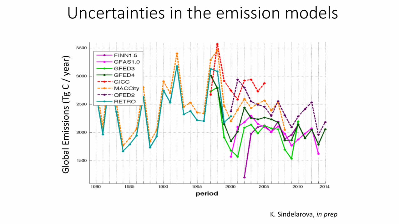
K. Sindelarova, in prep
Glo
bal
Em
issi
on
s (T
gC
/ y
ear)
Uncertainties in the emission models

E. McDonald-Buller, C. Emery, C. Wiedinmyer 2013
Uncertainties in the emissions• Emission Factors• Fire location/timing• Fuel loadings• Fuel Consumption
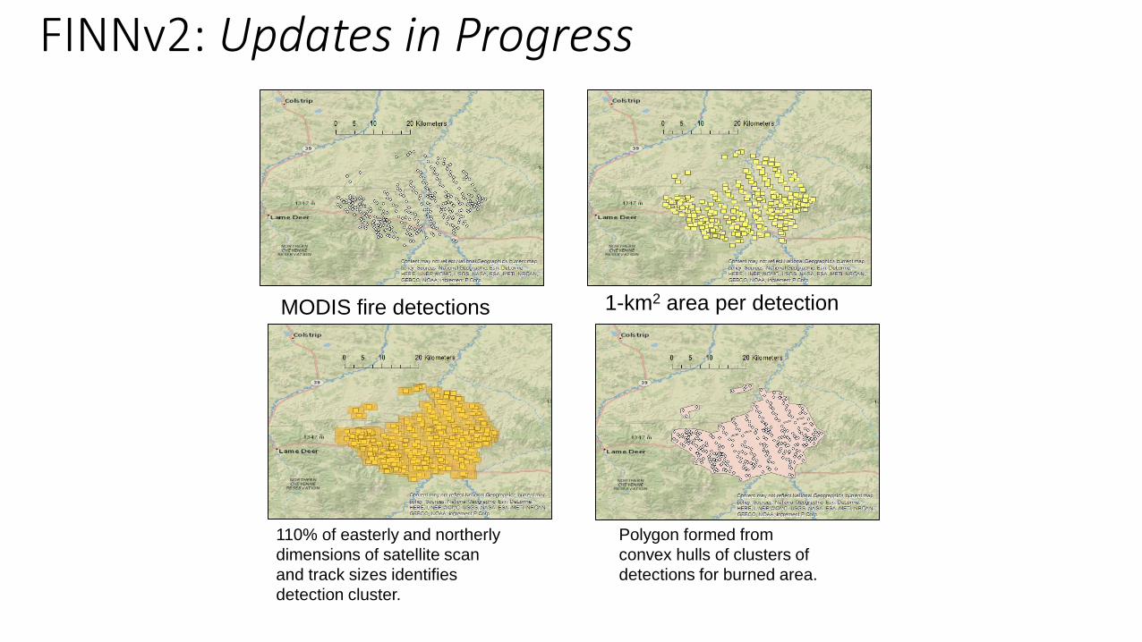
FINNv2: Updates in Progress
MODIS fire detections 1-km2 area per detection
110% of easterly and northerly Polygon formed from
dimensions of satellite scan convex hulls of clusters of
and track sizes identifies detections for burned area.
detection cluster.
E. McDonald-Buller, C. Emery, C. Wiedinmyer, Y. Kimura

FINNv2: Updates in ProgressComparing impacts from land cover inputs
FCCSFCCS/CDL
ESA-CCITCEQ/CDL
Texas
regional
E. McDonald-Buller, C. Emery, C. Wiedinmyer, Y. Kimura

FINNv2: Updates in Progress• Comparing impacts from land cover inputs
Annual regional total CO and
PM2.5 emissions during 2012
from FINN v.2.1.
Land cover influences
assignments of emission factors
and fuel loadings.
Specification of crops captures
seasonal activity but with little
effect on total emissions
*TCEQ regional land cover includes only Texas and the Lower Mississippi Valley (Louisiana, Mississippi, Arkansas). FCCS for CONUS and MODIS LCT applied elsewhere.
0
500
1000
1500
2000
2500
3000
3500
4000
4500
5000
Texas Lower Miss. Great Plains Southeast West
CO
Em
iss
ion
s (
Gg
/yr)
LCT GLC ESA FCCS or TCEQ FCCS_CDL or TCEQ_CDL
0
100
200
300
400
500
600
700
Texas Lower Miss. Great Plains Southeast West
PM
2.5
Em
iss
ion
s (
Gg
/yr)
LCT GLC ESA FCCS or TCEQ FCCS_CDL or TCEQ_CDL
E. McDonald-Buller, C. Emery, C. Wiedinmyer, Y. Kimura

What’s needed for forecasting?
Depends on…
• What scales are you looking at?
• Where in the world are you looking?
• What do you want to know?

Forecasting
• Fuels and Fire Danger in the US• https://www.predictiveservices.nifc.gov/fuels_fire-danger/fuels_fire-danger.htm
• NOAA Hazard Mapping System• http://www.ospo.noaa.gov/Products/land/hms.html
• Naval Research Laboratory• https://www.nrlmry.navy.mil/aerosol/• Includes FLAMBE emissions and forecasts
• GEOMAC• https://www.geomac.gov/viewer/viewer.shtml
