circulate san diego
TRANSCRIPT
Circulate San Diego 233 A Street, Suite 206
San Diego, CA 92101 Tel: (619) 544-9255
Fax: (619) 531-9255 www.circulatesd.org
Creating excellent mobility choices and vibrant, healthy neighborhoods.
July 15, 2021 Mayor Todd Gloria City Administration Building 202 C Street, 11th Floor San Diego, CA 92101 Dear Mayor Gloria and City Council: On behalf of Circulate San Diego, whose mission is to create excellent mobility choices and vibrant, healthy neighborhoods, I am writing to offer suggestions for the forthcoming “Spaces as Places” program. In general, Circulate San Diego would like to offer its support for this new and innovative program. The COVID-19 pandemic has been difficult and tragic for San Diegans, but among its silver linings was the creative and collaborative effort of business and government leaders to reimagine how outdoor public space can be used. San Diegans learned that parking spaces can be transformed into inviting and exciting gathering places. Restaurants and other businesses were able to operate when they might have otherwise shut down. The conversion of parking spaces into parklets, streateries, and other human-scale uses creates vibrant people-centered streets. The design of these outdoor spaces can contribute to a sense of community and aesthetics in a neighborhood. The draft “Spaces as Places” plan includes streateries, social curbs, promenades, and private outdoor dining. In order to ensure the best possible outcomes for our communities, the City should:
I. Prioritize Existing and Planned Transit, Bicycle, and Pedestrian Improvements; II. Ensure that Uses of the Right-of-Way are Safe; III. Create a Streamlined, Efficient Process; and IV. Allow a Broad Spectrum of Placemaking Projects that are Open to the Public. V. Ensure that Design Restrictions are Minimal
I. Prioritize Existing and Planned Transit, Bicycle, and Pedestrian Improvements
While the creation of vibrant outdoor spaces is a worthy pursuit, it cannot come at the expense of transit, bicycle, or pedestrian infrastructure. San Diego is still in the early stages of developing a fully-functional network of bicycle and transit lanes that will offer San Diegans real mobility choices to get to their destinations. This infrastructure is critical to ensuring that San Diego meets its Climate Action goals. Therefore, public right of way dedicated to bicycles or transit should not be used for “Spaces as Places”
Creating excellent mobility choices and vibrant, healthy neighborhoods.
2
projects. Conversion of the public right-of-way should not be allowed even where planned bicycle or transit lanes will not be completed for several years. Businesses that begin using public space will naturally begin to depend on that space and feel entitled to it. Allowing interim use of outdoor space creates future conflicts when those uses are forced to give way to bicycle and transit facilities. This can already be seen in conflicts around outdoor dining facilities that have been built in the way of the planned 30th street bikeway. If the City does allow for temporary uses on planned bicycle and transit facilities, permits should only be issued if an applicant signs an acknowledgment that the facility is planned, and to agree not to oppose its creation. The City should consider all dedicated right-of-way planned for bicycle lanes in the SANDAG 2021 Regional Plan, as well as in the City of San Diego Bicycle Master Plan, and individual community plans. Unfortunately, it is unclear from the Draft 2021 regional plan which Rapid busses will run on dedicated right-of-way. The City should therefore not allow right-of-way to be used for “Spaces as Places” along planned Rapid bus lines, unless it is certain that it will not interfere with future transit lanes.
II. Ensure that Uses of the Right-of-Way are Safe Streateries and parklets must be safe for their users. At an impact speed of roughly 30 mph, a pedestrian has a 50% chance of being seriously injured and a 25% chance of dying.1 At a speed of 23 mph, those figures reduce to 25% and 10%, respectively.2 Without protective measures, streateries and parklets should not be allowed on streets with speed limits greater than 25 mph. Moreover, the City should consider traffic calming measures and reduced speed limits in areas with significant numbers of streateries and parklets. There is currently a bill being considered in the legislature, AB 43, which would give local governments greater ability to lower speed limits. If it passes, the City will have more ability to lower speed limits in areas with streateries. For streets with speed limits greater than 25 mph, streateries should be adequately protected from on-street traffic. A quick-build approach could allow these streateries to operate safely without the expense of full sidewalk extension. Permanent curb extensions may require mapping and moving utilities, approvals from many city departments, and high construction costs. In contrast, several cities, including Oakland,3 New York City,4 and Los Angeles,5 have implemented quick build curb extensions for pedestrian safety and for outdoor dining. Photos of these types of projects are in Attachment 3. These projects require only paint, planter boxes, and flex posts. These quick-build projects create safety through visual separation, physical separation, and barriers. Flex posts and paint visually indicate a separation in space, and can be placed beyond the boundaries of a
1 Tefft, B.C., Impact Speed and a Pedestrian’s Risk of Severe Injury or Death (Technical Report), AAA FOUNDATION FOR
TRAFFIC SAFETY (2011), available at https://aaafoundation.org/impact-speed-pedestrians-risk-severe-injury-death/#:~:text=The%20average%20risk%20of%20death,Risks%20vary%20significantly%20by%20age. 2 Id. 3 Roger Rudick, “Oakland’s Quick-Build Protected Intersections are Safer,” STREETSBLOG SF (Aug. 4, 2020), available at https://sf.streetsblog.org/2020/08/04/oaklands-quick-build-protected-intersections-are-safer/. 4 “Pedestrian Street Seats,” NEW YORK CITY DEPT. OF TRANSPORTATION (accessed Jun. 16, 2021) https://www1.nyc.gov/html/dot/html/pedestrians/streetseats.shtml. 5 “Breaking Ground!” SOUTH ROBERTSON BOULEVARD (accessed Jun. 16, 2021) https://soroblvd.com/author/soroblvd_em51ym/.
Creating excellent mobility choices and vibrant, healthy neighborhoods.
3
streatery’s structure, creating a buffer. Barriers like bollards, crash barriers, planter boxes, and other sturdy constructions can deflect or reduce the impact of collisions. The City should create standards for safety on streets with speed limits greater than 25 miles per hour that incorporate some or all of these elements.
III. Create a Streamlined, Efficient Process The process for creating streateries, social curbs, promenades, and private outdoor dining spaces should be as easy as possible. Previous placemaking policies in San Diego have been hampered by complicated and confusing City processes. In August 2016, Circulate San Diego released a report, “A Place for Placemaking,” which contained recommendations for how the City of San Diego might encourage placemaking.6 Highlighted projects included parklets, repurposed vacant properties, street murals, and decorative crosswalks.7 In response to advocacy from a coalition of community partners, the City adopted an ordinance on placemaking in May 2018.8 Unfortunately, that ordinance has not resulted in substantial placemaking in San Diego because the permitting process is too burdensome. In order to obtain a permit under the placemaking ordinance, an applicant must submit (1) a General Application (DS-3032), (2) a Storm Water Requirements Applicability Checklist (DS-560), (3) an Encroachment Exhibit detailing the encroachment area, and (4) a Construction Plan (DS-3179 or DS-3179C).9 In addition, the applicant must calculate how much they owe in fees. The fees may be considerable and it is not obvious how expensive a placemaking permit might be given the various charges levied by the City depending on the circumstances of the permit.10 Furthermore, applicants must agree to pay for all maintenance and navigate a maze of regulatory requirements.11 These extensive and confusing requirements mean that very few placemaking projects have been permitted under the City’s ordinance. These requirements are particularly exclusive of low-income people, people of color, and immigrants, who face greater obstacles in navigating the requirements and paying fees. The “Spaces as Places” program should learn from past efforts, and create a permitting process that is easy to navigate. The program should offer a menu of pre-approved options so that businesses and community groups are not left wondering what will meet the City’s standards. In addition, the City should allow deviation from the pre-approved menu, with clear guidelines on what the City will or will not approve.
6 Kathleen Ferrier and Joe Cosgrove, “A Place for Placemaking,” CIRCULATE SAN DIEGO (Aug. 2016), available at https://www.circulatesd.org/placeforplacemaking. 7 Id. 8 CITY OF SAN DIEGO ORD. NO. 20928 (May 22, 2018), available at https://www.sandiego.gov/sites/default/files/placemaking.pdf. 9 CITY OF SAN DIEGO INFORMATION BULLETIN 568 (July 2018), available at https://www.sandiego.gov/sites/default/files/dsdib568.pdf. 10 See CITY OF SAN DIEGO INFORMATION BULLETIN 502 (July 2019), available at https://www.sandiego.gov/sites/default/files/dsdib502.pdf. 11 See CITY OF SAN DIEGO INFORMATION BULLETIN 568 (July 2018), available at https://www.sandiego.gov/sites/default/files/dsdib568.pdf; CITY OF SAN DIEGO INFORMATION BULLETIN 565 (August 2020), available at https://www.sandiego.gov/sites/default/files/dsdib565.pdf.
Creating excellent mobility choices and vibrant, healthy neighborhoods.
4
Permitting fees should be obvious and relatively inexpensive, particularly for projects that are open to the public. The process should require only a single permit application, and require no technical diagrams unless absolutely necessary. Where technical diagrams are required, applicants from historically disinvested communities should receive assistance from the City in completing them. Moreover, the process should be ministerial, and the City should commit to approving or denying permits within 30 days, as is the case in San Francisco.12
IV. Include a Broad Spectrum of Placemaking Projects that are Open to the Public As it implements “Spaces as Places,” the City has an opportunity to revisit its placemaking ordinance, which did not create the number of community engagement and individualized neighborhood projects that it sought. In addition to permitting streateries, social curbs, promenades, and private outdoor dining, the “Spaces as Places program should allow permits for other uses of the public right of way, including:
Parklets (pedestrian plazas);
Decorative crosswalks;
Intersection murals;
Activation and re-purposing of underutilized public land; and
Other community-led projects. In “A Place for Placemaking,” Circulate San Diego highlighted projects like Linda Placita, a conversion of a section of parking lot at the Linda Vista Library into a “pavement park,” which hosted dance concerts, kids activity days, movie nights, and other community gatherings; Chollas Creek Crossing, which converted a vacant lot into a revitalized community gathering space; intersection murals in Pacific Beach; and Manzanita Gathering Space, an art-filled community space on a formerly vacant lot in City Heights.13 Unfortunately, these kinds of projects still face the barriers they faced in 2016: an expensive and complicated permitting process that excludes residents who do not have the knowledge or wealth to navigate it, and a lack of City investment.14 A program that allows local businesses to have exclusive use of portions of the public right of way must give special consideration to groups who wish to use public spaces to create community resources for all. Creation of the above-mentioned placemaking projects should be even easier to accomplish than streateries. Moreover, funds from the revenues generated from streateries should be made available to assist placemaking projects that benefit historically disinvested communities.
V. Ensure that Design Restrictions are Minimal In order to achieve its goal of creating vibrant, neighborhood specific projects, Spaces as Places needs to leave room for the creativity of businesses and communities. The design manual and menu of pre-approved designs should highlight opportunities for customization, and give guidance for acceptable
12 “Making the Shared Spaces Program Permanent,” SF.GOV (accessed 6/17/2021), https://sf.gov/information/making-shared-spaces-program-permanent. 13 Kathleen Ferrier and Joe Cosgrove, “A Place for Placemaking,” CIRCULATE SAN DIEGO (Aug. 2016) at p. 5-7, available at https://www.circulatesd.org/placeforplacemaking. 14 Id. at p. 7-8.
Creating excellent mobility choices and vibrant, healthy neighborhoods.
5
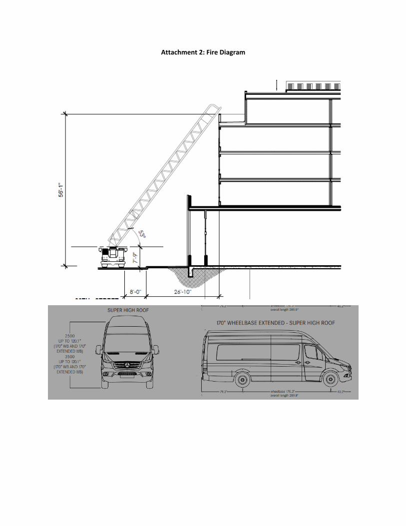
deviations from those designs. Moreover, safety concerns should be addressed in a manner that preserves public safety without creating unnecessary blanket prohibitions. Creative crosswalks, intersection murals, and other projects allow neighborhoods to express their individuality. While Hillcrest has succeeded in installing a rainbow crosswalk, the Creative Crosswalk Pilot Program allows only bars of solid block color in between white continental crosswalk markings.15 Intersection murals are permitted, but may not contain text and must go through the burdensome placemaking permitting process. These pilot programs are too cumbersome and restrictive to allow the projects that would benefit San Diego neighborhoods. A fully realized placemaking process could result in, for example, Tony Gwynn crosswalks at Petco Park, an intersection mural expressing Vietnamese heritage in Little Saigon, or any of a variety of projects to enhance and reflect our unique communities. Historically, City engineers have objected to crosswalks that deviate from standard crosswalk designs on the grounds that they may be unsafe or that the City could lose federal funding. As shown in the Attachment 1, creative crosswalks with a variety of designs have been implemented in cities like Long Beach, San Francisco, Oakland, Portland, and Washington, D.C. These cities have not lost federal funding, nor are we aware of any data to show that creative crosswalks are more dangerous than standard crosswalks. Creative crosswalks draw even more attention than a standard crosswalk, and may even enhance pedestrian safety. The City’s creative crosswalk policy should be updated to allow greater design freedom and allow creative crosswalks to be put on larger roads with unique neighborhood character, like El Cajon Boulevard, University Avenue, Market Street, and Convoy Street. More recently, fire officials have objected to the use of overhead structures on streateries and sidewalk cafes. While fire concerns must be taken seriously, every effort should be made to preserve the ability of streatery operators to use overhead structures. Overhead structures provide shade and a sense of place, and offer an opportunity for creativity in design. When designing buildings, San Diego builders have been asked to ensure that fire ladders can reach a building from the street, even where a vehicle up to 10 feet high and 24 feet long is parked in the parking lane, as shown in Attachment 2. This suggests that design restrictions for streateries (such as a 10 foot height limit and a 24 foot length limit), could successfully resolve fire concerns.
VI. Conclusion The City’s proposed “Spaces as Places” program has the potential to enhance San Diego neighborhoods and businesses. While doing so, the City should make sure not to repeat the mistakes of the past, maximize potential benefits, and give particular attention to projects that create spaces that are open to the public or benefit historically disinvested communities.
15 CITY OF SAN DIEGO MEMORANDUM “Pilot Program for Creative Crosswalks in Public Right-of-Way (ROW),” (Feb. 7, 2019), available at https://www.sandiego.gov/sites/default/files/pilot_program_for_creative_crosswalks_in_public_right-of-way_row_02-11-2019.pdf.
Creating excellent mobility choices and vibrant, healthy neighborhoods.
6
Sincerely,
Jesse O’Sullivan Policy Counsel Circulate San Diego CC: Councilmember Joe LaCava Councilmember Dr. Jennifer Campbell Councilmember Stephen Whitburn Councilmember Monica Montgomery Steppe Councilmember Marni von Wilpert Councilmember Chris Cate Councilmember Raul Campillo Councilmember Vivian Moreno Councilmember Sean Elo-Rivera Brittany Bailey Alyssa Mutto Sameera Rao James Nagelvoort
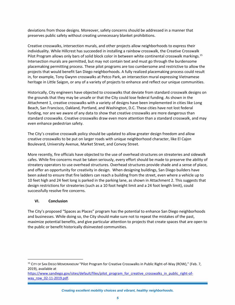
Attachment 1: Creative Crosswalks
Pine Avenue, Long Beach, CA:
Five unique crosswalk designs were installed on Pine Avenue in Long Beach in March 2017.
“Creative Crosswalks,” DOWNTOWN LONG BEACH ALLIANCE (accessed June 12, 2021),
https://downtownlongbeach.org/public-realm/creative-crosswalks/.
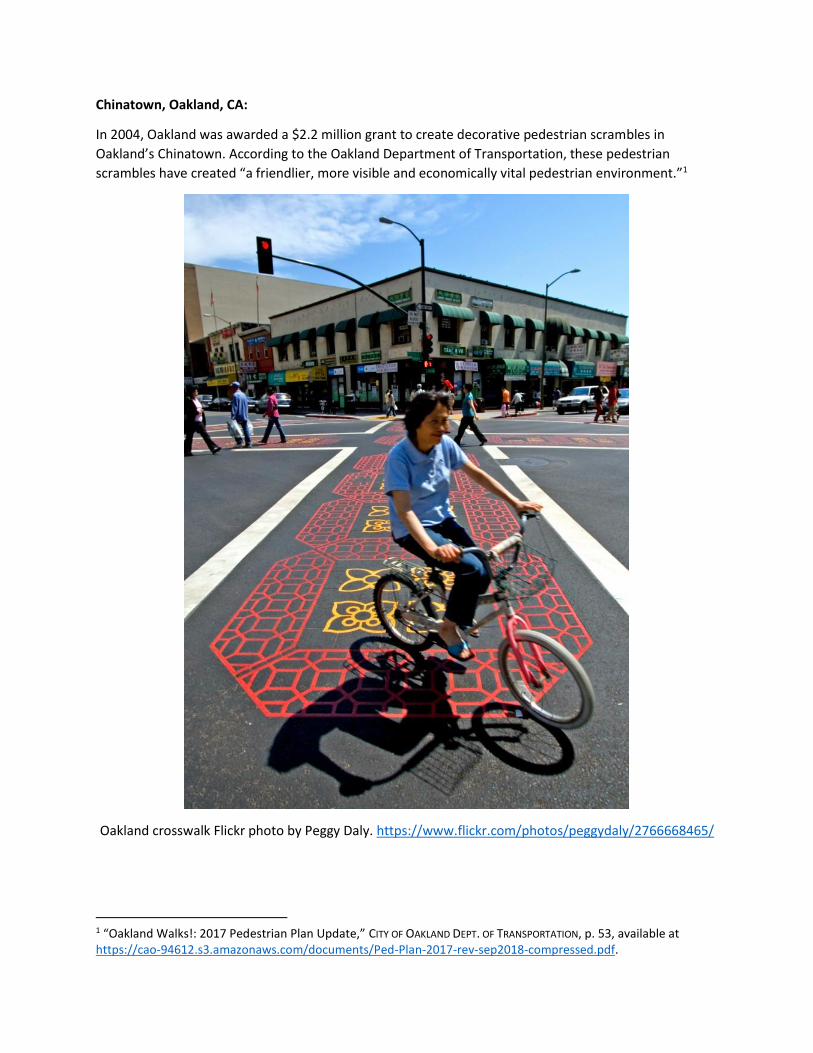
Chinatown, Oakland, CA:
In 2004, Oakland was awarded a $2.2 million grant to create decorative pedestrian scrambles in
Oakland’s Chinatown. According to the Oakland Department of Transportation, these pedestrian
scrambles have created “a friendlier, more visible and economically vital pedestrian environment.”1
Oakland crosswalk Flickr photo by Peggy Daly. https://www.flickr.com/photos/peggydaly/2766668465/
1 “Oakland Walks!: 2017 Pedestrian Plan Update,” CITY OF OAKLAND DEPT. OF TRANSPORTATION, p. 53, available at https://cao-94612.s3.amazonaws.com/documents/Ped-Plan-2017-rev-sep2018-compressed.pdf.
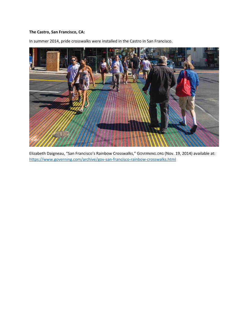
The Castro, San Francisco, CA:
In summer 2014, pride crosswalks were installed in the Castro in San Francisco.
Elizabeth Daigneau, “San Francisco’s Rainbow Crosswalks,” GOVERNING.ORG (Nov. 19, 2014) available at:
https://www.governing.com/archive/gov-san-francisco-rainbow-crosswalks.html
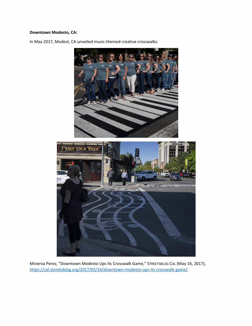
Downtown Modesto, CA:
In May 2017, Modest, CA unveiled music-themed creative crosswalks.
Minerva Perez, “Downtown Modesto Ups its Crosswalk Game,” STREETSBLOG CAL (May 16, 2017),
https://cal.streetsblog.org/2017/05/16/downtown-modesto-ups-its-crosswalk-game/.
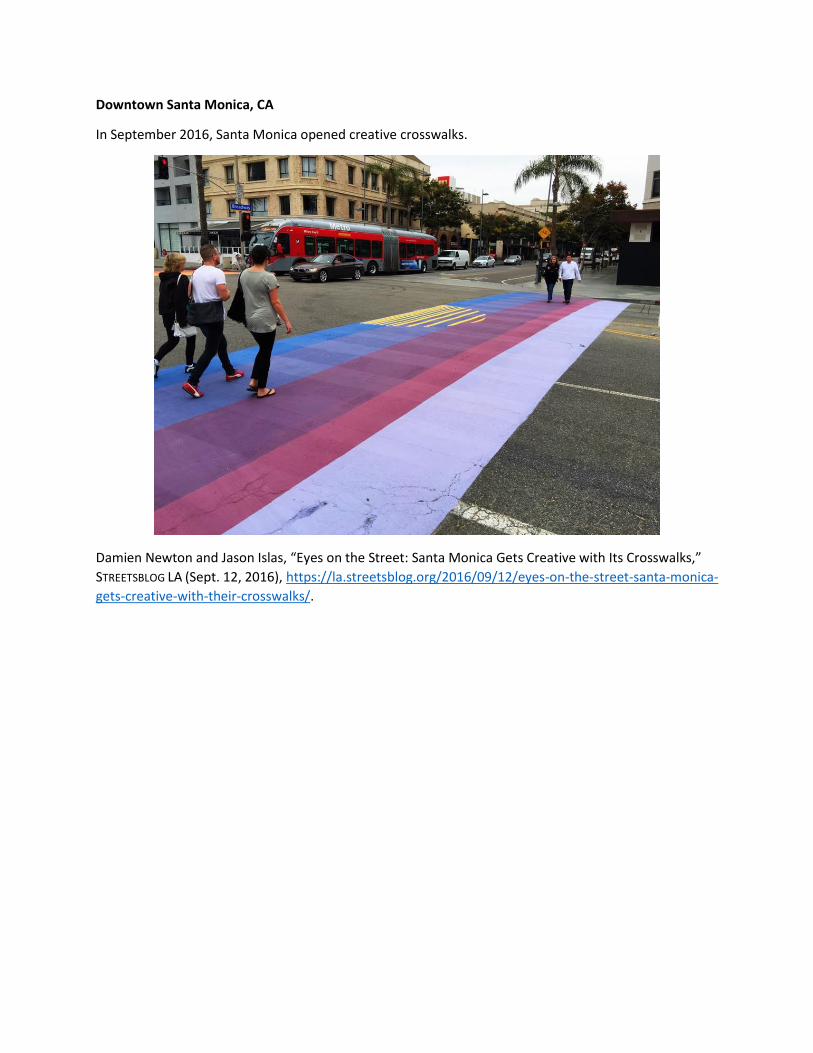
Downtown Santa Monica, CA
In September 2016, Santa Monica opened creative crosswalks.
Damien Newton and Jason Islas, “Eyes on the Street: Santa Monica Gets Creative with Its Crosswalks,”
STREETSBLOG LA (Sept. 12, 2016), https://la.streetsblog.org/2016/09/12/eyes-on-the-street-santa-monica-
gets-creative-with-their-crosswalks/.
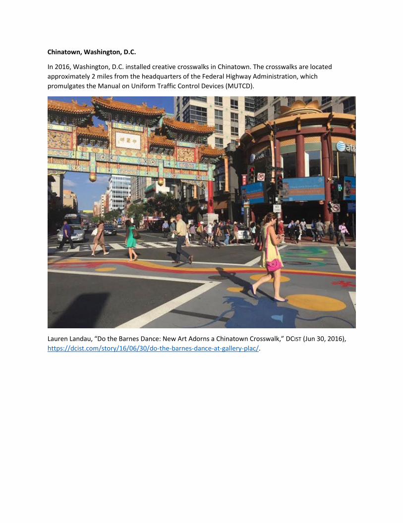
Chinatown, Washington, D.C.
In 2016, Washington, D.C. installed creative crosswalks in Chinatown. The crosswalks are located
approximately 2 miles from the headquarters of the Federal Highway Administration, which
promulgates the Manual on Uniform Traffic Control Devices (MUTCD).
Lauren Landau, “Do the Barnes Dance: New Art Adorns a Chinatown Crosswalk,” DCIST (Jun 30, 2016),
https://dcist.com/story/16/06/30/do-the-barnes-dance-at-gallery-plac/.
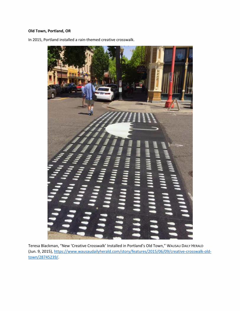
Old Town, Portland, OR
In 2015, Portland installed a rain-themed creative crosswalk.
Teresa Blackman, “New ‘Creative Crosswalk’ Installed in Portland’s Old Town,” WAUSAU DAILY HERALD
(Jun. 9, 2015), https://www.wausaudailyherald.com/story/features/2015/06/09/creative-crosswalk-old-
town/28745239/.
Attachment 2: Fire Diagram
Attachment 3: Quick Build Curb Extensions
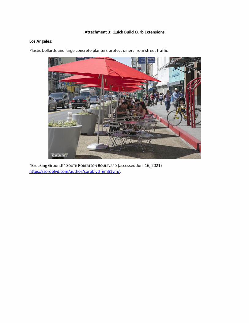
Los Angeles:
Plastic bollards and large concrete planters protect diners from street traffic
“Breaking Ground!” SOUTH ROBERTSON BOULEVARD (accessed Jun. 16, 2021)
https://soroblvd.com/author/soroblvd_em51ym/.
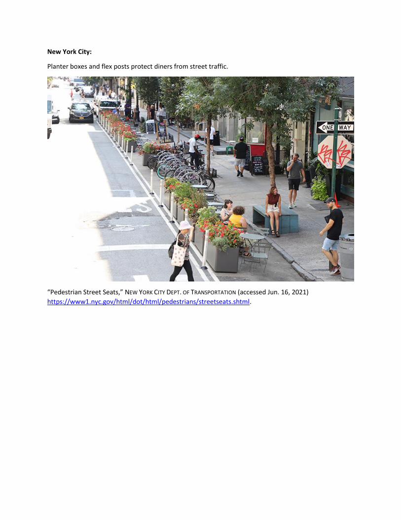
New York City:
Planter boxes and flex posts protect diners from street traffic.
“Pedestrian Street Seats,” NEW YORK CITY DEPT. OF TRANSPORTATION (accessed Jun. 16, 2021)
https://www1.nyc.gov/html/dot/html/pedestrians/streetseats.shtml.
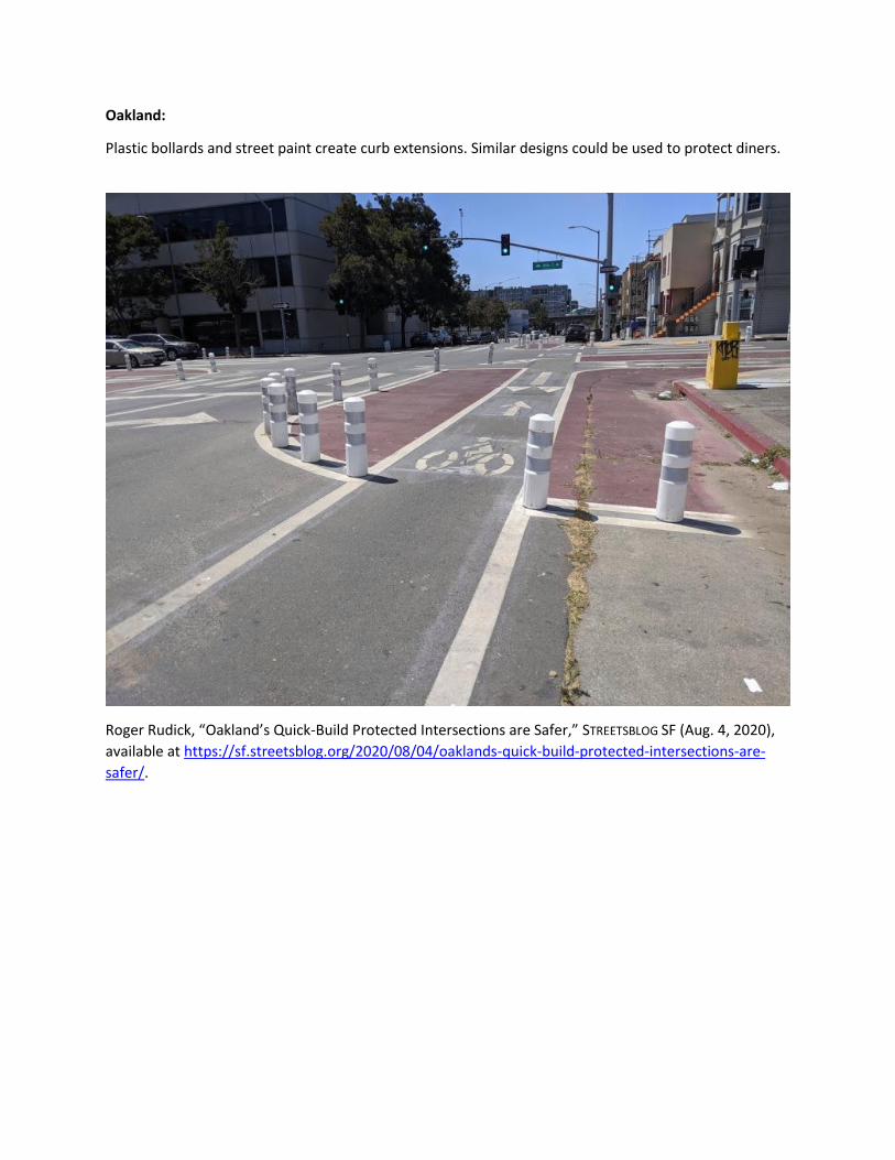
Oakland:
Plastic bollards and street paint create curb extensions. Similar designs could be used to protect diners.
Roger Rudick, “Oakland’s Quick-Build Protected Intersections are Safer,” STREETSBLOG SF (Aug. 4, 2020),
available at https://sf.streetsblog.org/2020/08/04/oaklands-quick-build-protected-intersections-are-
safer/.