city centre bus plan
TRANSCRIPT

Delivering on the City Centre Masterplan July 2021
City Centre Bus PlanThe Proposed Plan for Auckland’s City Centre Bus Services

Header
PAGE 2 Auckland’s City Centre Bus Plan
Contents
1. Introduction and context page 8Purpose of this plan 8The future role of the city centre 9The future transport system of the city centre 11The future of buses in the city centre 14
2. The current situation, issues and opportunities page 16
3. Our proposed plan for the city centre’s bus future page 27
4. Infrastructure we need page 33
Message from the Chief Executive page 3
Executive Summary page 4
5. Benefits of the City Centre Bus Plan page 34
6. Delivery timeframes page 37

PAGE 3
Message from the Chief Executive
Auckland’s city centre is the economic heartbeat of Aotearoa and is on a journey to become an even better place to live, work and play. The city centre is home to 40,000 people, 100,000 people come to work here and 37,000 students study in the precinct. Thousands more visit for everything from a quiet dinner to a major event. Whether they are living, working or visiting, all these people have similar goals – they want to be able to access and move around the city centre safely and with ease.
Buses are part of the lifeblood of the city centre and will continue to be an important means of access. Currently, around half of the people who travel into Auckland’s city centre at peak times arrive using public transport. Every morning, 700 buses bring the same number of people as 25,000 cars into the city centre.
Buses will contribute over $500 million in direct economic value to the central Auckland economy over the next thirty years.
Space in the city centre is constrained, many streets are narrow, and land is densely developed. Auckland has not had a city centre bus station since 2003 and now bus facilities are dispersed and require 1.2 kilometres of on-street kerbside space to accommodate bus stops and layovers.
Buses form part of an integrated transport system which also includes walking, cycling, micro mobility and cars. All these modes meet in the city centre. As Auckland’s population continues to grow, demand for bus travel will also increase, putting additional pressure on our city centre streets.
Shane Ellison CHIEF EXECUTIVE OFFICER
Even with the construction of the City Rail Link and the planned new rapid transit corridors to Māngere and Westgate, most Aucklanders arriving in the city centre using public transport will do so by bus.
Auckland Council has developed the 2020 City Centre Masterplan (CCMP) to be the key guiding document for the Auckland Council whānau, setting the strategic direction for the city centre to create an accessible, inclusive, connected, safer and sustainable environment for everyone. It prioritises mode shift, public transport and people movement and was strongly supported during public consultation.
One of the key features in the CCMP is Access for Everyone (A4E) which has the core focus of creating a more walking and cycling friendly environment and providing significant priority for public transport to, from and within the city centre to ensure increased access, growth and vibrancy of the city centre, as with other world class cities.
In recognising the importance of Auckland’s city centre, the CCMP and A4E, we need to have a strategic plan for the way people use buses and the infrastructure buses need to provide a great customer experience. This proposed City Centre Bus Plan provides a basis for engaging with our community on what our city centre bus network might look like in the future.
Auckland Transport has developed this proposed City Centre Bus Plan in close coordination with our council whānau to help address many of these issues and, importantly, help deliver on the CCMP. By changing our bus network, creating dedicated bus corridors through
the city centre, and building new dedicated bus facilities, we can improve access to the city centre, remove buses from narrow side streets, greatly reduce the need for buses to wait outside shops, homes and businesses, and vastly improve the experience for people catching buses in the city centre.
This proposed plan also helps address our climate change obligations; our recently approved Low Emission Bus Roadmap commits to zero emission buses in the city centre and this plan complements the roadmap. Along with A4E we will be able to remove all fossil-fuelled vehicles from the Waihorotiu/Queen Street Valley.
Now more than ever, we need a greater focus on public transport and active modes to contribute to climate change solutions, and we need to steer our transport thinking towards moving people rather than moving vehicles.
This proposed plan would support the vision for Tāmaki Makaurau as a place for everyone to enjoy.
Me haere tahi tāua. We should travel together.
We want to hear your views on this exciting plan so we can ultimately end up with a City Centre Bus Plan which delivers the best solution for bus customers, residents, businesses and a thriving city centre.
Shane Ellison
CHIEF EXECUTIVE, AUCKLAND TRANSPORT

Auckland Transport is excited to share with you the approach it aims to take in planning for buses in Auckland’s city centre to help deliver the outcomes in the City Centre Masterplan (CCMP)
Executive Summary
PAGE 4 Auckland’s City Centre Bus Plan
The city centre is undergoing a transformation right now, with the Downtown project nearing completion and work on the City Rail Link (CRL) continuing. While these projects will deliver improvements for public and active transport, buses are (and will continue to be) a key part of the transport system to and from the city centre.
Buses are flexible, they connect people to, from and within the city centre from places without rail connections and they are space efficient. Even cities with large rail networks have buses playing a major role in the transporting of people.
The bus network in Auckland has undergone many changes in the past five years, and patronage has improved significantly as a result. However, in some ways the bus system has been a victim of its own success; there are now more people taking the bus, meaning there are more bus services needing to travel through (and stop in) the city centre. At the same time, there is increasing demand on all road space in the city centre, as more pedestrians, cyclists and deliveries take place.
Auckland Transport has developed this plan to ensure that the bus network can continue to operate into the future and meet the needs of the city. This plan will help deliver the outcomes of the CCMP, which prioritises the city centre as a place for people, so we can all enjoy a safe, healthy and well-connected city centre. You can find out more about the CCMP at http://aucklandccmp.co.nz/
The plan would also contribute to substantial improvements in air quality and environmental targets for the city centre.
There are 35 general traffic lanes into the city centre which carry the same number of people as the seven current bus lanes (30,000 people each morning)

PAGE 5
Step 2Establish dedicated facilities for urban and inter-regional bus passengers. These facilities would include safe and comfortable waiting spaces, facilities for drivers, and bus charging facilities. Possible locations for these are in the Wynyard Quarter, Beach Road, Learning Quarter and Downtown areas.
Step 3Make changes to services so that bus routes run through the city centre rather than only to the city centre. This would free up at least 1 kilometre of kerbside space that could be used for people to share and enjoy.
Step 1
Create two high quality dedicated east-west bus corridors on Customs Street/Fanshawe Street and Wellesley Street, with fewer, higher quality and safer stops.
The plan has three steps:Auckland Transport aims to make the city centre safer and more pedestrian friendly. This City Centre Bus Plan contributes to AT’s broader plan for transport in the city centre, focussing on moving people rather than vehicles.
We want to make sure our city centre bus services are customer centric, easy to use, efficient to operate and can support the vision for the city centre, as set out in the City Centre Masterplan.
Executive summary
• Customer benefits – ensuring buses are part of an integrated transport system in the city centre, so that regardless of which mode Aucklanders use, they can connect, transfer and reach their destination.
• Operational improvements – delivering bus services that are more efficient and have the space necessary to operate alongside other modes in the city centre.
• Strategic alignment – delivering the bus related outcomes of the CCMP and supporting the future shape of the city.
The City Centre Bus Plan will deliver:
This plan will not happen overnight. There will be many changes to services and infrastructure over the next 5-10 years to deliver this plan. We want you to be aware of these changes; to know they are part of the plan and will make the buses, the transport system and the city centre better for all Aucklanders.

Executive summary
PAGE 6 Auckland’s City Centre Bus Plan
Engagement
We are releasing this City Centre Bus Plan now to show how we think the bus network and infrastructure for buses in the city centre needs to evolve over time, as part of the wider transport system and to deliver on the CCMP.
Aucklanders were overwhelmingly supportive of the CCMP, 76 per cent of submitters supported it’s general direction. Throughout the feedback there was a general desire for urgency, tangible action and progress towards the goals and direction expressed in the CCMP. The City Centre Bus Plan is Auckland Transport’s response for buses to deliver the outcomes sought in the CCMP.
We wanted to take the opportunity to inform you of the continued importance and value of the bus network for the city centre, and how we intend to integrate buses alongside all other transport modes in the city centre, including City Rail Link and proposed light rail.
As we progress through the business case and subsequent delivery phases we will be formally consulting on the specific proposals outlined in this paper.
At this stage we would like your views on whether you think this City Centre Bus Plan will help deliver the CCMP – please provide feedback through AT.govt.nz/CityCentreBusPlan
Closing date for feedback is 19 September 2021.

PAGE 7

PAGE 8 Auckland’s City Centre Bus Plan
Purpose of this planThis proposed plan sets out the approach Auckland Transport (AT) aims to take in planning for buses in Auckland’s city centre over the next 10 years.
• Section 1 sets out the context and future of the city centre overall, the supporting transport system and buses specifically
• Section 2 sets out the existing situation for bus travel to/in the city centre, the issues, challenges and emerging opportunities and benefits, from a customer, operational and strategic alignment view
• Section 3 sets out AT’s proposed plan for addressing the issues and leveraging the opportunities.
We completed a technical bus reference case in 2020 (available on the AT website1) detailing existing and approved bus routes and bus volumes over the next 10 years. The City Centre Bus Plan builds on the bus reference case and focuses on the infrastructure we need to achieve future bus routing and volumes.
1 https://at.govt.nz/media/1985159/bus-reference-case-2020-report.pdf
1. Introduction and context

PAGE 9
Header
The future role of the city centreThe city is a place where people come together, where culture is shared and shaped and where commerce develops. Cities exist as a critical part of the human experience and this critical role of the city means the transport system to and within the city is also vital, to support these commerce, interaction and cultural activities.
Auckland’s city centre is a small but important area, surrounded by the central motorway ring. While it represents less than 0.1% of the Auckland region by area, it generates 20% of the region’s gross domestic product (GDP) and 7.4% of the country’s GDP. It is the highest density employment area in the country and supports 125,000 jobs. This is expected to grow substantially over the next 10 years. The city centre’s resident population has more than doubled in recent years to approximately 40,000 and is forecasted to continue to grow strongly, with an additional 15,000 residents expected in the coming decade.
While the COVID-19 global pandemic has meant that Auckland’s city centre is currently quieter than before, cities have existed for thousands of years, and Auckland will recover. Population and employment growth and a desire to reconnect will see people returning to the city centre in coming years.
Aucklandcity centre
students in higher education in the city centre
37,000 There are approximately
jobs in the city centre
125,000 There are approximatelyGenerates 20% of the region’s
gross domestic product (GDP) and 7.4% of the country’s GDP
AKLGDP
NZGDP
20% 7.4%
people live in the city centre (that’s about the same as the entire Taupō District).
40,000 Approximately
1. Introduction and context

PAGE 10 Auckland’s City Centre Bus Plan
HeaderHeader
1616
1616
11
11
11
KINGSLAND
MORNINGSIDE
GREY LYNN
PONSONBY
ARCH HILL
HERNE BAY
MTEDEN
VIADUCTHARBOUR
EDENTERRACE
NEWMARKET
PARNELL
WESTERNSPRINGS
GRAFTON
FREEMANSBAY
ST MARYSBAY
WYNYARDQUARTER
PORTS OF AUCKLAND
THREELAMPS
MyersPark
AlbertPark
SparkArena
AucklandDomain
WesternPark
VictoriaPark
GreyLynnPark
Arch Hill Scenic Reserve
Dove-MyerRobinson
Park
ThomasBloodworth
Reserve
AyrReserve
Alberon Reserve
NewmarketPark
Symonds StCemetery
TahakiReserve
MountEden
PointErinPark
Shore RdReserve
Eden Park
WesternSpringsFields
Mercy AscotHospital
Auckland Hospital
StarshipChildrensHospital
Westhaven
St Marys Bay ViaductBasin
Judges Bay
Universityof Auckland
Uni.of Akl.
AUT
Universityof Auckland
Auckland Boys’Grammar
KowhaiInt. Sch.
St Paul'sCollege
St Mary'sCollege
Mount AlbertPrim. Sch.
FreemansBay Sch.
Auckland Girls'Grammar
PonsonbyInt.Sch.
Epsom Girls'Grammar
St Peter'sCollege
AUCK
LAND
HAR
BOUR
BRI
DGE
DO
MIN
ION
RD
SOUTHERN MOTORW
AY
UPPE
R Q
UEE
N S
T
DOMAIN DR
GRA
FTO
N R
D
GR
AFTO
N R
D
NORTHERN MO
TORW
AY
NORTHWESTERN MOTORWAY
NORTHWESTERN MOTORWAY
STANLE
Y ST
THE STRAND
JELLICOE ST
DALD
Y ST
GAUNT ST
HA
LSEY
ST
FANSHAWE ST
ALEX EVANS ST
NEW N
ORTH RD
LOW
ER H
OBS
ON
OVE
RBRI
DG
E
SYM
ON
DS
ST
NEW NORTH RD
QUAY ST
GREAT NORTH RD
GREAT NORTH RD
QUAY ST
IAN
MA
CK
INN
ON
DR
KHYBER PASS RD
GIL
LIES
AVE
NEW
TON
RD
CRO
WH
URS
T ST
FANSHAWE ST
CUSTOMS ST EAST
WATERLOO QUADRANT
LOW
ER A
LBER
T
HO
BSO
N S
T
HO
BSO
N S
T
NEL
SON
ST
NEL
SON
ST
ANZAC AVEBEACH RD
PARNELL RISE
CARLTON GORE RD
PITT ST
KITC
HEN
ER S
T
HO
WE ST
BOSTON RD
WILLIAMSON AVE
FRANKLIN RD
BON
D ST
COLLEGE HILL
MO
UN
TAIN
RD
RICH
MOND RD
ALTEN RDGLADSTONE RD
SURREY CRESCENT
RED
MO
ND
ST
STANLE
Y ST
AYR ST
SHEL
LY B
EACH
RD
BOSTON RDNU
GEN
T ST
SYMONDS ST
GRAFTON BRIDGE
WELLINGTON ST
PAR
K RD
HOPETOUN ST
PARNELL RD
BOWEN AVE
MO
UNTA
IN R
D
JERVOIS RD
JERVOIS RD
MT
EDEN
RD
KHYBER PASS RD
BEA
CH RD
BEAU
MO
NT S
T
BEA
UM
ON
T ST
WELLESLEY ST WEST
KARANGAHAPE RDKARANGAHAPE RD
REMUERA RDBRO
AD
WAY
BRO
AD
WAY
WELLESLEY ST EAST
GRA
FTO
N R
D
TAN
GIH
UA S
T
FANSHAWE ST
PON
SON
BY RD
PONSONBY RD
MAYORAL DR
VICTORIA ST WEST
UNION ST
COOK ST
CU
RR
AN
ST
SHORTLAND ST
ALB
ERT
ST
ALB
ERT
ST
VINC
ENT
ST
GREYS AVE
MORROW ST
SECCOMBES RD
PAKENHAM ST WEST
DA
LDY
ST
MADDEN ST
PICTON ST
JOH
N ST
SARSFIELD ST
MAYORAL DR
HEP
BURN
ST
BASSETT RD
QU
EEN
ST
QU
EEN
ST
QU
EEN
ST
QU
EEN
ST
UN
ION ST
TUARANGI RD
CRUMMER RD
CRUMMER RD
WA
KEFIELD ST
WYNDHAM ST
CITY RD
ST PAUL ST
ALFRED ST
PARLIAMENT ST
MOUNT ST
EAST ST
FOX ST
GARFIELD ST
ST G
EOR
GES
BAY
RD
BATH ST
KENT ST
TEED ST
ROSE RD
BARRY ST
HEP
BURN
ST
BROWN ST
ANGLESEA ST
VERMONT ST
O'NEILL ST
TOLE ST
COWAN ST
RUSKIN ST
NORFOLK ST
SUMMER ST
MIDDLE ST
DOUGLAS ST
GU
DG
EON
ST
NEW
STST M
ARY'S RD
SCOTLAND ST
PONSONBY TERRACE
NAPIER ST
PARK
AVE
DIC
KEN
S ST
CH
AM
BER
LAIN
ST
NEW BOND ST
TITOKI S
T
GROSVENOR ST
MAUNSELL RD
EMMET ST
FARNHAM ST
CLEVELAND RD
MOIRA ST
AR
DM
OR
E RD
SENTIN
EL RD
KING ST
AR
NO
LD ST
PRIME RD
ELGIN ST
COLERIDGE ST
HARCOURT ST
NORTHLAND ST
GREEN ST
DUBLIN ST
HOME ST
KING
ST
HOME STCOOK ST
JOH
N ST
WA
NG
AN
UI AV
E
ALB
AN
Y RD
TAWARIKI ST
SCH
OFIELD
ST
LINCOLN ST
ARIKI ST
NICHOLLS LN
MURDOCH RDTHE CRESCENT
KITCHENER ST
FED
ERA
L ST
CARLTON GORE RD
HEP
BURN
ST
POLLEN STMACKELVIE ST
SUSSEX ST
SCANLAN ST
EDEN ST
WAKEFIELD ST
PRIN
CES
ST
PRIN
CES
ST
HA
MILTO
N R
D
CLA
REN
CE ST
BRAD
FORD
ST
IRELAND ST
COLLINGWOOD ST
ISLING
TON
ST
ELLI
OTT
ST
TYLER ST
GALWAY ST
GO
RE S
T
GO
RE S
T
COM
MER
CE S
T
Wynyard Quarter/Viaduct Harbour precinct Core transport hub
Universities (Learning Quarter)
Port
Karangahape Rd precinct
Retail and business centre
Aotea/Civic precinct
High level indication of major current land uses in the city centre
The city centre has evolved into a series of distinct precincts and identities.

PAGE 11
The future transport system of the city centre
1. Introduction and context
As the city centre continues to serve its critical purpose as a connection and interaction point for the entire region, so too will the region’s transport system continue to ‘meet’ at the city centre.
Auckland Transport, together with Auckland Council and Waka Kotahi NZ Transport Agency, has developed Future Connect and the Regional Land Transport Plan, which together are an integrated transport plan for the region, including the city centre, across all transport modes. This plan responds to the land use plan for the city centre outlined in the CCMP and overall aspirations set out in the Auckland Plan 2050.
Pedestrians in particular are already prevalent across the city centre, but are not yet provided for in a way which recognises their important role. The entire city centre has been designated part of the strategic walking network, with interventions aimed at improving the time and space allocation to pedestrians a key part of the transport plan. This will mean more priority, more accessibility and a more legible network for pedestrians, so Aucklanders can move around easier.
New rapid transit corridors will commence construction in the next ten years. Auckland Council and the NZ Government have agreed that new services are needed to complement the existing train and busway corridors. City centre to Māngere via Mt Roskill and city centre to Westgate via northwestern motorway are two priority corridors which have been identified. Should they proceed to construction, they will further impact and benefit access to and within the city centre.
Freight will continue to need to access the city centre. Large freight will connect to the Port of Auckland via the motorway network and The Strand. The plan is to improve this connection, making it safer while also enabling smoother freight access. Couriers and deliveries will also be a critical part of the city centre transport system going into the future. AT is working towards a future with more loading and servicing space and more dynamic space on the kerb across the city centre, to service the many shops, cafes, businesses and homes.
All of these improvements mean that the public transport system must be integrated, so that regardless of which mode Aucklanders use, they can connect, transfer and reach their destination in a comfortable and reliable manner.
Cyclists and micromobility users too will be better catered for in the future city centre. A network of strategic cycleways has been planned for the city centre, connecting to the Harbour Bridge and Grafton Gully, as well as along Victoria Street as part of the proposed linear park, and the existing facilities along Nelson Street, Karangahape Road and Tāmaki Drive.
Public transport is set to see a transformation for Aucklanders in the city centre over the next decade. The City Rail Link will open in a few years, meaning that train services can operate at far higher frequencies, making the region more connected. It will also mean that the city centre will be home to three train stations, rather than just Britomart, and significantly improved bus services.
Ferries, too, are expected to improve their service offering. The new Downtown Ferry Terminal, complete in 2021, will make catching a ferry easier than ever. AT is working with operators on improvements to ferry services and aims to keep supply of services in line with demand, particularly from growing communities.
General traffic will see big changes to the city centre in the future. As part of the need to improve access for underserved modes (walking, cycling and micromobility, and public transport) general traffic movement will be changed to accessing the city centre via the motorway network into nearby precincts. The city centre will no longer be a thoroughfare for traffic, but a destination.

PAGE 12 Auckland’s City Centre Bus Plan
NEW N
ORTH RD
CUSTOMS ST EAST
WELLESLEY ST WEST
KARANGAHAPE RD
VICTORIA ST WEST
Rail and station entrances
Light rail and stations
Green link
East/west bus routes
Desirable locations for Rapid TransitNetwork (RTN) bus terminals
Albert Park Tunnels re-opening(private sector proposal)
The future transport system of the city centre continued
1. Introduction and context
ALBE
RT S
T
SYMO
NDS S
T
WELLESLEY ST
QUEE
N ST
CUSTOMS ST
QUAY ST
A more walking and cycling friendly environment is a core focus for the city centre transport system. Through a series of interventions, the intent is to prioritise these sustainable travel options.
Significant priority for public transport to, from and within the city centre is also necessary to ensure increased access, growth and vibrancy of the city centre, as with other world-class cities.
As shown on the left, different transport corridors have different priorities. In future, on Wellesley Street, Customs Street, Symonds Street and Albert Street, buses will have the highest priority of any mode.
The vision for the city centre as set out in the CCMP, identifies Wellesley Street and Customs Street as priority bus routes.
Icon size indicates priority of transport modes

PAGE 13
NEW N
ORTH RD
CUSTOMS ST EAST
WELLESLEY ST WEST
KARANGAHAPE RD
VICTORIA ST WEST
Rail and station entrances
Light rail and stations
Green link
East/west bus routes
Desirable locations for Rapid TransitNetwork (RTN) bus terminals
Albert Park Tunnels re-opening(private sector proposal)
Vision for the City Centre as set out in the CCMP, with transit corridors on Wellesley Street and Customs Street
Britomart StationLand and sea transport hub, rail, light rail, bus and ferries
Potential Quay Park Transport HubSupport development by including transport infrastructure planning
Learning Quarter InterchangeBus transport hub providing connection to the universities
Wynyard QuarterTransport infrastructure planning serving the developing Wynyard Quarter
Aotea StationRail and bus transport hub
Dominion RoadA potentially new 21st century inner city suburb based around a hub of trains, light rail and bus
Karangahape Road StationRail and bus transport hub connecting to light rail and bus network

PAGE 14 Auckland’s City Centre Bus Plan
Why would we still need buses when we will have CRL?
Even after CRL, buses will continue to bring more people into the city centre than other public transport modes. The importance of bus networks is also evident in mature Metro systems such as London. London’s bus network is one of the largest and most comprehensive urban transport systems in the world, carrying around 6 million passengers per weekday – almost as many as London Underground and suburban rail combined – and trips on buses have increased by more than 50% since 2000. The London bus system carries more passengers than the rest of England combined. The bus network plays a vital role in providing access to jobs and town centres, the Underground and rail services. The network is also dynamic and responds to London’s growth and changing needs. Improvements like bus priority measures and their enforcement, central London congestion charging scheme, low emission bus zones, cleaner, greener buses and improved bus routes have all contributed towards meeting the rising demand for bus travel while ensuring enhanced service levels and quality service.
The future of buses in the city centre
1. Introduction and context
We made significant changes to the bus network between 2016 and 2018 so people could travel more easily across the region, not just to the city centre, and at any time of day. Since COVID, people have changed how and when they travel around Auckland so now, more than ever, flexibility in our public transport services is vital.
Buses will continue to perform a critical role in connecting people to the city centre. Even with additional rapid transit in the form of City Rail Link and the planned new corridors to Māngere and Westgate, most Aucklanders’ nearest public transport option will be a bus. Unless there is investment in additional facilities, as the population grows and bus demand does too, pressure on the city centre streets will increase, buses will be stuck in ever-increasing congestion and customers will find it harder to locate and connect between buses.
Given these issues, the need for a city centre bus plan is clear. More details on the existing situation and emerging challenges for buses in the city centre is outlined in the next section. Even after CRL, buses will continue to
bring more people into the city centre than other public transport modes.

PAGE 15
Header1. Introduction and context
By the end of 2025, AT plans to have 50% of buses operating in the city centre during peak periods to be zero emission, contributing to a 53% reduction of greenhouse gas emissions from buses
A key part of the future of buses – Zero emission electric fleet
In November 2017, the Mayor of Auckland joined politicians from 11 other cities around the world in signing the C40 Fossil-Fuel-Free Streets Declaration. The declaration commits Auckland to buying only zero emission buses from 2025 and ensuring a major area of the city centre is zero emission by 2030. This includes implementing a Zero Emissions Area (ZEA) within the Queen Street Valley, requiring all vehicles (including buses) to be electric or other non-emitting vehicles.
AT has developed a Low Emission Bus Roadmap which provides a plan to move all our buses to zero emission by 2040.
In December 2020, the AT Board approved an accelerated move to zero emission buses starting from July 2021. This will be subject to funding from Auckland Council to support achieving achieving Auckland’s Climate Plan goals and funding from central government to support the decarbonisation of bus public transport in New Zealand.
The Mayor’s proposal is for no new diesel buses to be procured from 1 July 2021, and having a full low emission fleet by 2040, with transition over time. There is an opportunity to accelerate the transition to 2035 subject to additional funding. For the city centre, we are committed to a zero emission operation by 2030.
Completing the move to electric buses by 2035 would reduce Auckland Transport carbon emissions from buses to just over 10 percent of the 93,000 tonnes it was emitting in 2019.
Electric buses will need charging at off-street facilities. Moving buses to off-street facilities rather than ending their services on-street will also help with improving air quality.
33 zero emission buses
April 2021
1. Introduction and context

PAGE 16 Auckland’s City Centre Bus Plan
The city centre is a critical location for Auckland, and the entire country. It must work well – for our customers, for our transport system and for the vision for the future. There has been significant growth and change in the city centre over the past decade, and this has had an impact on the public transport system for the city centre. The City Centre Bus Plan aims to respond to and address the issues and opportunities set out according to:
• Customer issues and opportunities
• Operational issues and opportunities, and
• Strategic alignment issues and opportunities.
Wynyard Quarter
Viaduct Harbour
Viaduct Basin
Aotea Centre
Aotea Square
Grand Millenium
Town Hall
Ferry Building
The University of Auckland
The University of Auckland
The University of Auckland
Auckland City
Hospital
Starship Children’s Hospital
Albert Park
MyersPark
Victoria Park
WesternPark
ConstitutionHill
Auckland University of Technology
SkyCity
AMP
St Patrick’sCathedral
Auckland Girls Grammar
School
StamfordPlaza
M Social
Downtown Carpark
Commercial Bay
FreybergPlace
Freemans Bay Primary
PIER 1PIER
2PIER 4
30295309
309X
Express servicevia motorway
NX282
802923 82
802923
NX1, 9597, 931
933, 939
NX1, NX2, 82802, 95, 97, 923
931, 933, 939
931933939
931933939
9597
30295309
309X
222425
2224
222475
30295309
309X
2224252730
295309
309X
18, 110, 125X129, 195, 209
18, 110, 125X129, 195, 209
132, 133, 134132X, 133X
18, 110 129, 132 133, 134 195, 209
18, 110, 129 132, 133, 134
195, 209
125X 132X 133X
24
24
25
NX1
NX2
75
20
20
2222
105
105
105
72X
70
321
27
755
Inner
Inner
Inner
Inner
Inner
Tāmaki
Tāmaki
Outer Outer
Outer
Outer
Outer
City
City
75
75
75
75
City
City
City
27321
22242527
2075
20101
106
106
106
106
106
101
27
101101
321
321
3217570
Inner
105106
105106
755762
27321
774775
76277477570
72X
7072X
7072X
7072X
7072X
Express servicevia motorway
Express servicesvia motorway
Com
mer
ce S
t
Eden Cr
Stan
ley
St
Tang
ihua
St
Tinl
ey S
t
Plum
mer
St
Mahuhu Cr
Alfred St
Swanson St
Wyndham St
Anzac Ave
Beach Rd
High St
Shortland St
Kitc
hene
r St
Ellio
tt S
t
Fede
ral S
t Fe
dera
l St
Hob
son
St
Cook St
Nel
son
St
Nel
son
St
Mar
ket P
l
Wellesley St W
Wellesley St W
Victoria St W
Victoria St W
Victoria St E Victoria St W
Mayoral
Dr
Hopetou
n St
Airedale St
Wakefield St
Mount St
St Paul St
Scotia Pl
Vinc
ent S
t
Mayoral Dr
Pitt St
Grey
s Ave
Grafton Rd
Park Rd
Gra
fton
Rd
Alex Evans St
Merc ury Ln U
pper
Que
en S
t
Que
en S
t
Que
en S
t
Howe St
Grafton Bridge
City Rd
St Martins Ln
Wellington St
Union St
Sale St
Drake St
Dock St
Hardinge St
Westhaven Dr
Beau
mon
t St
Alten Rd
Stur
dee S
t
Prin
ces
St
Wellesley St E
Wellesley St E
Bowen Ave Waterloo Qd
Sym
onds
St
Sym
onds
St
Sym
onds
St
Pakenham St E
Gore St
Karangahape Rd
Beau
mon
t St
Hal
sey
St
Halsey St
Dal
dy S
t D
aldy
St
Jellicoe St
Pakenham St W
Gaunt St
Madden St
Fran
klin
Rd
Irela
nd S
t
Middle St
Napier St
College Hill
Hep
burn
St
Fort St
Fort St
Vulcan Lane
Picton St
Karangahape Rd
Hob
son
St
Queen St
Queen St
Fanshawe St
Fanshawe St
Fanshawe St
Alb
ert S
t A
lber
t St
Low
er A
lber
t St
Customs St E
Tyler St
Galway St
Customs St W
Quay St
Colling
wood
St
Anglesea
St
2.The current situation, issues and opportunities
The current city centre bus network is illustrated here. Buses typically arrive on one of several key arterial routes into the city centre.
CURRENT CITY CENTRE ROUTES AND TERMINALS (JULY 2021)
Key
Route Start
Services in this direction only
Central City Link
North Inner Link
East Outer Link
West Tāmaki Link
Note: Outbound routes only shown except Link services & 106 Freemans Bay Loop

Pre-COVID, around 30,000 people entered the city centre by bus every morning. Demand for public transport into the city centre is set to more than double by 2038 (see graph). This is because of ongoing growth in city centre jobs, along with a continued increase in the city centre population.
Even after the City Rail Link (CRL) is delivered, train services significantly increase, and light rail is complete, most city centre public transport users will still arrive by bus. This is because many people travel from areas not served by rail, or ferries, or light rail (in the future), or for whom buses are a better option. Once they are in the city centre, many people use buses to travel locally, e.g. from Britomart towards the universities. So even after CRL and light rail start running in Auckland, we’ll still need a lot of buses in the city centre.
Because the current bus network is focused on routes that terminate in a small part of the city centre, many people heading in on buses are unable to get to their ultimate destination conveniently. For instance, many employees at Wynyard Quarter commute from the Eastern Bays (Mission Bay, St Heliers). These passengers currently have long, difficult transfers to make in the city centre. The current network also makes accessing certain key destinations, such as the Hospital, difficult. This lack of convenience is frustrating for customers and leads to fewer people choosing to use public transport for these journeys.
2. The current situation, issues and opportunities
70,000
60,000
50,000
40,000
30,000
20,000
10,000
0
PEOPLE INTO CITY CENTRE (2 HOURS AM PEAK)
Bus Train FerryLight rail (LRT)
times as many people catch buses into the city every morning, as those who catch trains.2 1/2
PAGE 17
2038203120242019

PAGE 18 Auckland’s City Centre Bus Plan
2. The current situation, issues and opportunities
ALB
ERT
ST
ALB
ERT
ST
HO
BSO
N S
T
HO
BSO
N S
T
QU
EEN
ST
QU
EEN
ST
FANSHAWE ST
FANSHAWE STSY
MO
NDS
ST
SYM
ON
DS S
T
WELLESLEY ST WELLESLEY ST
BEACH RD
BEACH RD
CUSTOMS ST CUSTOMS ST
QUAY ST QUAY ST
12,000 13,300
2,5002,10
0
8,00
0
2,00
0
9,20
0
900
500 800
1,200
4,600
1,400
1,300
Average number of people entering the city centre on buses by corridor (6-9am)
Buses will always be an important means of access to the city centre.
There are some corridors that simply cannot be served by train or light rail, and are entirely dependent on buses as a means of public transport access to the city centre. Corridors such as Tāmaki Drive and College Hill are never likely to be served by heavy or light rail.
* 2038 scenario assumes light rail on Dominion Rd and Northwestern motorway
Current 2038*
120%
60%
283%15%
55%
12%
15%
2,900
from North Shore
from Kingsland, Pt Chevalier
from NW Motorway
from Newmarket
from Sandringham, Mt Eden, Dominion Rd, New North Rd
from Parnell
from Tāmaki Drive
from Manukau Rd

2. The current situation, issues and opportunities
700 buses, carrying the same number of people as 25,000 cars, arrive in the city centre every morning. 700
25,000 cars
The number of buses arriving in the city centre is expected to rise by a further 25% within a decade to meet growth requirements.
PAGE 19
140,000
120,000
100,000
80,000
60,000
40,000
20,000
0
FORECAST INCREASE IN PUBLIC TRANSPORT USE INTO AUCKLAND CITY CENTRE
Dai
ly tr
ips
into
the
city
cen
tre
People in private cars People in public transport
2016 2028 2038 2048

PAGE 20 Auckland’s City Centre Bus Plan

PAGE 21
Benefits of buses for the
city centre
Provides flexibility for all users, at all timesThe availability of frequent bus routes provides freedom at all times. Many bus routes run at least every 15 minutes between 6am to midnight, 7 days a week.
Can run on existing roads, so does not require new infrastructure to be built for them to operate, making them flexible in an ever-changing city centre.
Feeder connections to a wide range of destinationsIt is possible to access the city centre by bus on all key arterials into the city centre. The city centre is a key part of Auckland’s connected public transport network. Over half of Auckland’s population can reach the city centre within an hour on public transport.Reducing emissions
Buses take cars off the road which reduces greenhouse gas emissions.
AT’s commitment to transitioning to zero emission bus fleet by 2040, will also contribute significantly to the reduction of greenhouse gas emissions. AT are committed to having zero-emission buses in city centre by 2030.
Buses in the city centre currently save around 11.3 million kilograms of CO2 per annum.
Will contribute over $500 million in direct economic value
to the central Auckland economy over the next thirty years.
High capacity and reduces road congestionBuses help move people around in a sustainable and space efficient way. One bus can take 33 cars off the road. A high-quality bus corridor can transport 10,000 passengers per hour, in each direction.
2. The current situation, issues and opportunities

PAGE 22 Auckland’s City Centre Bus Plan
What our customers tell us
We regularly collect feedback from our customers, and they have told us that buses in the city centre don’t always meet their needs. There are four main areas that need to be addressed:
• Transfers: Around 35% of bus trips to the city centre are transferring to other services. Currently, making these transfers is difficult and feedback shows that customers are not happy with their experience. Customers want transfers to be easier.
• Legibility: The dispersed nature of city centre bus stops makes it difficult for customers to find their way around. Effective wayfinding (such as local area maps, clear signage and intuitive routes to onward destinations) is critical to ensure the success of connected journeys, as this can decrease frustration, stress, anxiety, late arrivals and time spent seeking directions.
• Safety: There are times where customers feel unsafe while waiting for their bus in the city centre, or on their walk to/from their stop or station. This impacts their decision to use or support public transport. We need more real-time information boards, better lighting and shelter. Public transport users need to feel safe at all points of their journey.
• Travel Time: Frequent city centre traffic congestion means bus travel times can vary enormously across the day. Customers want reliable journey times for travel into and through the city centre and do not want to get caught in congestion.
Having attended various events in the city I have been dismayed to find I need to walk to Hobson Street in order to get the bus home. It is dark , ill lit and a long distance so therefore highly uncomfortable, and frankly bloody scary, for women after dark.”
“
Fiona, regular public transport user
“ I usually leave plenty of time when transferring in case something goes wrong, which means that there is a lot of waiting around. So it makes me anxious, bored, and frustrated.”Leo, regular public transport user
of bus customers rate transfers in city centre as
45% compared to the Auckland average of
68%8+ 10out of
2. The current situation, issues and opportunities

PAGE 23
We have also received a lot of feedback through consultation on the City Centre Masterplan (CCMP) and New Bus Network:
• Bus journey times are too slow, so we need to prioritise bus travel through the city centre.
• Residents and businesses are concerned about the amenity and environmental impacts of buses using city streets for parking and waiting for more than a very short period of time.
• The perception that the city centre is for cars, so we need to change to a city centre focussed on people not vehicles.
Operational issues
There is limited space in the city centre, and buses offer an extremely space-efficient way of moving people into the city centre.
Efficient and customer-oriented bus services require kerb space for bus stops and short-term bus parking, and off-street areas for driver facilities, longer term bus parking and integrated interchanges. The ability to store buses (ideally off-street) throughout the day when they are not operating is also important. They also need prioritised road space across key city centre corridors so people can get to where they need to be as quickly as possible.
The number of people entering the city centre on public transport has tripled over the past 25 years, but the space for buses has decreased and become more dispersed over time, as new streetscape (e.g. Lower Queen Street, Quay Street) or other transport uses (e.g. Britomart Station and Nelson Street cycleway) have been established.
Until 2001, Auckland had an off-street Downtown bus terminal located where the Britomart train station is now. An alternative off-street facility in the city centre has not been found since then.
Facilities in the city centre do not meet operational requirements. Facilities for drivers in the city centre are inadequate and cannot support any more growth in bus journeys to and from the city centre. The Employment Relations Amendment Act (ERAA) 2018 supports bus driver wellbeing and allows time for breaks during a typical driving shift. Bus drivers must also have safe and convenient facilities to attend to their personal needs. This means providing toilet facilities in more stations across the region, including the city centre.
Buses need appropriate locations to park when they are not operating. Many business owners understandably do not want parked buses obstructing their business so, over time, these parking locations have moved away from the central area. However, this contributes to central city congestion and it increases operational cost. Currently, buses take up more than 1.2 kilometres of kerbside space for operations and bus stops which could be better used as spaces for people to share and enjoy.
2. The current situation, issues and opportunities
There are 35 general traffic lanes into the city centre which carry the same number of people as the seven current bus lanes (30,000 people each morning)

PAGE 24 Auckland’s City Centre Bus Plan
SECTION AA QUAY WEST - PROPOSED_
14.7M
NORTHERN
PUBLIC REALM
5.0M
MOVEMENT
2.5M
TREE
AVENUE
4.2M
CYCLE LANE
2-WAY
2.9M
VEHICLE
5.0-8.0M
MOVEMENT
3.25M
BUS
C.L
3.0M
TREE
AVENUE
3.25M
BUS
2.9M
VEHICLE
3.0M
TREE AVENUE
VARIES
FERRY BASIN EDGE
FALL 2%
RL 3.50
RL 3.20
RL 3.56
FFL 3.74
12.3
CARRIAGE WAY
8.0M
SOUTHERN
PUBLIC REALM
35.0M
QUAY ST
(TOTAL)SEAWALL
(VARIES)
FALL 2%
FALL 2%
Location Plan
AA
Site Boundary
Centreline
Low point
QUAY STREET CENTRALCONCEPT
DRAFT
www.landlab.co.nz Quay Street West Tāmaki Makaurau_ Concept Design Report_ version 002_ 1st May 2018_ page _072
This drawing represents the proposed cross section for the ‘western block’ of Quay Street (between Lower Albert Street the Eastern Viaduct).
Design Summary:
• The southern (city) pedestrian zone consists of 5.0m movement zone and:
• 3.0m flexible zone including planting/trees/outdoor dining/occupation & furniture)
• Traffic is composed of two bus lanes and two vehicle lanes to meet minimised/slow speed (30km/h),
• The cycleway (4.2m wide) is integrated into the flush surface treatment /separated from vehicle traffic.
• The northern footpath zone remains at 7.5m total and includes a flexible 5.0m movement and 2.5m furniture & tree zone.
• Triple row informal tree avenue and green infrastructure.
An example demonstrating how a street can be given over to people is the recently completed Quay Street project.
2. The current situation, issues and opportunities

PAGE 25
Inter-Regional Coach issuesIt is not just the urban bus system with opportunities to improve. Auckland’s Inter Regional Coach Terminal (IRCT) is currently located in Hobson Street, within the SkyCity complex. From here customers can take coaches to various points across the North Island. More than 70 inter-regional coaches arrive in and depart from the facility every day, carrying approximately 3,000 people. There are also SkyBus services to and from Auckland Airport and other coach facilities across the city.
The long-term needs of coach operators and customers need to be considered.
2. The current situation, issues and opportunities

PAGE 26 Auckland’s City Centre Bus Plan
Some of AT’s strategic objectives are:
• Providing better travel choices for Aucklanders
• Better connecting people, places, goods and services
• Providing an excellent customer experience for all service and customers.
The current bus services in the city centre doesn’t fully support these strategic objectives. The way bus stops in the city centre are spread out and the lack of intuitive wayfinding makes navigating the city centre difficult and limits accessibility.
In the Downtown area, more than 150 buses per hour end their service at nine disparate on-street locations. A person coming from Takapuna town centre and heading to Mission Bay has their bus dropping them on Wellesley Street near the Civic Theatre. They then need to walk 900m to Customs Street to catch the TāmakiLink to reach their destination. This is one of many similar scenarios throughout the city centre.
Compare this to Manukau Bus Station, which has all routes in the area served by a single bus station. Passengers wishing to transfer between buses can simply get off one bus, wait under cover and board another bus from within the same station. A single interchange point for Auckland’s city centre may not be feasible given the size of our bus network, but we can significantly improve the current situation, to deliver on our strategic objectives and goal of easy journeys.
Misalignment with strategy
Wynyard Quarter
PrincesWharf
QueensWharf
MarsdenWharf
BledisloeWharf
Captain CookWharf
Viaduct Harbour
Viaduct Basin
Ferry Building
PWCAMP
St Patrick’sCathedral
StamfordPlaza
M Social
Downtown Carpark
Commercial Bay
PIER 1PIER
2PIER 4
Com
mer
ce S
t
Eden Cr
Tang
ihua
St
Tinl
ey S
t
Plum
mer
St
Mahuhu Cr
Swanson St
Wyndham St
Anzac Ave Beach Rd
High St
Shortland St
Fede
ral S
t
Mar
ket P
l
Stur
dee S
t
Bowen Ave Waterloo Qd
Pakenham St E
Gore St
Fort St
Fort St
Vulcan Lane
Hob
son
St
Queen St
Fanshawe St
Fanshawe St
Alb
ert S
t
Customs St E
Tyler St
Galway St
Customs St W
Quay St Quay St
9597
132, 132X, 133 133X, 134
18, 110, 125X129, 195, 209
NX1
9597
NX1
321
27
755
TāmakiLink
TāmakiLink
105106
755762
27321
774775
762774775
7072X
7072X
27321
7072X
Britomart
Downtown Ferry Terminal
EXAMPLE OF AN EFFECTIVE OFF-STREET BUS FACILITY IN MANUKAU
CURRENT DISPARATE NATURE OF BUS TERMINAL FACILITIES IN AUCKLAND CITY CENTRE
2. The current situation, issues and opportunities
An improved city centre bus network will allow customers to connect to access other parts of the region, improving the overall connectedness of the PT system and opening up more travel options for more people.

PAGE 27
This plan proposes changes to both bus routes and bus facilities in order to deliver several improvements. The Plan aims to:
• make the system simpler
• make the bus system easier to use – more legible more connected more reliable more accessible
• make the bus system operate better, including meeting customer and driver needs when buses aren’t operating
• future-proof for growth, with additional capacity
• contribute to Auckland’s bold strategic goals for the city centre.
Step 2Provide new customer centric bus facilities which will:• enable people to make their transfer in one place, • potentially integrate inter-regional coaches and urban buses, • include dedicated driver facilities, bus parking areas and electric
charging points, • improve customer experience and safety• provide cycling, micromobility and other active mode facilities.
Step 3
Change services so that routes run through the city centre instead of just to the city centre.
Step 1
Create dedicated reliable bus corridors along Customs Street/Fanshawe Street and Wellesley Street. Improve bus stop quality and accessibility.
3.Our proposed plan for the city centre’s bus future

PAGE 28 Auckland’s City Centre Bus Plan
Customs Street The number of buses on Customs Street is expected to more than double by 2028, compared with today. Customs Street is proposed to prioritise buses over cars. Dedicated, end-to-end bus priority lanes are proposed, with large and efficient, safe and comfortable bus stops. More than twice as many people would be able to travel on Customs Street when buses are prioritised, meaning more than 12,000 people per hour could travel through the corridor, in each direction.
In addition to dedicated bus lanes, more priority would be given to buses at signals along the Customs Street / Fanshawe Street corridor to help ensure bus journeys are as reliable as possible.
The proposed layout would restrict traffic movement to a single lane in each direction along Customs Street, with further restrictions on turns into and out of Customs Street.
Wellesley Street Wellesley Street is the key east-west bus corridor for the midtown area and needs to be developed to accommodate both very high bus volumes and very high pedestrian volumes, as it connects with the future Aotea Station and the two universities of the Learning Quarter.
The corridor also serves dense city centre locations including Wynyard Quarter and the Victoria Quarter, and allows transfers to the busy Albert Street and Symonds Street bus corridors.
We propose to provide dedicated end-to-end bus lanes, quality bus stops, and increased footpath space for the high volumes of customers anticipated. This is particularly critical in the area next to Aotea Station, where the highest number of pedestrians in New Zealand are expected.
The proposals for both Wellesley Street and Customs Street are being used as a key input to AT’s planning and modelling for Access for Everyone (ref CCMP Section 1.4).
2 https://www.aucklandccmp.co.nz/outcomes/outcome-2-connected-city-centre/greater-connectivity-by-public-transport/
ARTIST’S IMPRESSION OF A POTENTIALLY REVAMPED WELLESLEY STREET TO PRIORITISE BUS MOVEMENTS
GOOD QUALITY ON-STREET BUS FACILITY AT SYMONDS STREET
3. Our proposed plan for the city centre’s bus future
Step 1 The CCMP2 identifies Customs Street/Fanshawe Street and Wellesley Street as the major east-west routes for public transport across the city centre in the future. So, we propose two high quality east-west bus corridors to enable this.
Improving the quality and safety of bus stops Along these corridors, customers need a consistent, high quality bus stop and waiting environment. So we need to improve the quality of stops. An example of a high quality on-street bus stop is shown here.
We would provide fewer but higher quality bus stops on Customs Street and Wellesley Street to enable better customer experience and capacity. We would take opportunities to provide greenery within bus stop infrastructure to improve customer experience.
Bus parking areas would have minimum kerb height, a clear standing area with a sealed, smooth surface connecting the bus doors with the nearby footpath. This is important for customers with accessibility needs.
Seating, bins and passenger information displays at bus stops would ideally be designed as a part of the overall design and quality of the street.
Bus stops would be near pedestrian crossings connecting footpaths to and from bus stops. Natural landscaping would be incorporated in the bus stop area and consider bus operational needs.
We would address safety & security in and around bus stops with lighting, video surveillance and adequate street lighting.

PAGE 29
PONSONBY
ARCH HILL
HERNE BAYVIADUCT
HARBOUR
PARNELL
FREEMANSBAY
ST MARYSBAY
WYNYARDQUARTER
THREELAMPS
MyersPark
AlbertPark
SparkArena
AucklandDomain
WesternPark
VictoriaPark
GreyLynnPark
Dove-MyerRobinson
Park
Alberon Reserve
Symonds StCemetery
PointErinPark
Auckland Hospital
StarshipChildrensHospital
Westhaven
St Marys Bay ViaductBasin
Judges Bay
Universityof Auckland
AUT
St Paul'sCollege
St Mary'sCollege
FreemansBay Sch.
Auckland Girls'Grammar
PonsonbyInt.Sch.
AUCK
LAND
HAR
BOUR
BRI
DGE
UPPE
R Q
UEEN
ST
DOMAIN DR
GR
AFTO
N R
D
NORTHERN MO
TORW
AY
NORTHWESTERN MOTORWAY
STANLE
Y ST
THE STRAND
JELLICOE ST
DALD
Y ST
GAUNT ST
HA
LSEY
ST
FANSHAWE ST
ALEX EVANS ST
LOW
ER H
OBS
ON
OVE
RBRI
DG
E
SYM
ON
DS
ST
QUAY ST
GREAT NORTH RD
QUAY ST
NEW
TON
RD
FANSHAWE ST
CUSTOMS ST EAST
WATERLOO QUADRANT
LOW
ER A
LBER
T
HO
BSO
N S
T
HO
BSO
N S
T
NEL
SON
ST
NEL
SON
ST
ANZAC AVE
BEACH RD
PARNELL RISE
PITT ST
KITC
HEN
ER S
T
HO
WE ST
WILLIAMSON AVE
FRANKLIN RD
COLLEGE HILL
RICH
MOND RD
ALTEN RD
GLADSTONE RD
RED
MO
ND
ST
STANLE
Y ST
SHEL
LY B
EACH
RD
SYMONDS ST
GRAFTON BRIDGE
WELLINGTON ST
HOPETOUN ST
PARNELL RD
BOWEN AVE
JERVOIS RD
JERVOIS RD
BEA
CH RD
BEAU
MO
NT S
T
BEA
UM
ON
T ST
WELLESLEY ST WEST
KARANGAHAPE RD KARANGAHAPE RD
WELLESLEY ST EAST
GRA
FTO
N R
D
TAN
GIH
UA S
T
FANSHAWE ST
PON
SON
BY RD
PONSONBY RD
MAYORAL DR
VICTORIA ST WEST
UNION ST
COOK ST
CU
RR
AN
ST
SHORTLAND ST
ALB
ERT
ST
ALB
ERT
ST
VINC
ENT
ST
GREYS AVE
PAKENHAM ST WEST
DA
LDY
ST
MADDEN ST
PICTON ST
JOH
N ST
SARSFIELD ST
MAYORAL DR
HEP
BURN
ST
QU
EEN
ST
QU
EEN
ST
QU
EEN
ST
QU
EEN
ST
UN
ION ST
CRUMMER RD
WA
KEFIELD ST
WYNDHAM ST
CITY RD
ST PAUL ST
ALFRED ST
PARLIAMENT ST
MOUNT ST
EAST ST
FOX ST
GARFIELD ST
ST G
EOR
GES
BAY
RD
BATH ST
ROSE RD
BARRY ST
HEP
BURN
ST
BROWN ST
ANGLESEA ST
VERMONT ST
O'NEILL ST
TOLE ST
COWAN ST
RUSKIN ST
NORFOLK ST
SUMMER ST
MIDDLE ST
DOUGLAS ST
GU
DG
EON
ST
NEW
STST M
ARY'S RD
SCOTLAND ST
PONSONBY TERRACE
NAPIER ST
PARK
AVE
DIC
KEN
S ST
CH
AM
BER
LAIN
ST
EMMET ST
FARNHAM ST
CLEVELAND RD
MOIRA ST
AR
DM
OR
E RD
SENTIN
EL RD
AR
NO
LD ST
GREEN ST
DUBLIN ST
COOK ST
JOH
N ST
WA
NG
AN
UI AV
E
ALB
AN
Y RD
TAWARIKI ST
SCH
OFIELD
ST
LINCOLN ST
NICHOLLS LN
MURDOCH RDTHE CRESCENT
KITCHENER ST
FED
ERA
L ST
HEP
BURN
ST
POLLEN STMACKELVIE ST
SUSSEX ST
SCANLAN ST
WAKEFIELD ST
PRIN
CES
ST
PRIN
CES
ST
HA
MILTO
N R
D
CLA
REN
CE ST
BRAD
FORD
ST
IRELAND ST
COLLINGWOOD ST
ISLING
TON
ST
ELLI
OTT
ST
TYLER ST
GALWAY STGO
RE S
T
GO
RE S
T
COM
MER
CE S
T
AREAS IN THE CITY CENTRE INVESTIGATED AT A HIGH LEVEL FOR OFF-STREET BUS FACILITIES
Based on a high-level assessment of land in the city centre, AT have identified several possible off-street facility areas below.
Benefits of dedicated bus facilities
Better for air qualitybecause buses are not idling or circulating on the streets
Better use of footpaths and road space for all modes
Lower operating cost
Avoids having buses waiting on streets which deteriorates the quality of the street
Less circulation of buses
Better for customers as they are separated from buses which provides better waiting environment
Step 2 We would develop customer facing facilities that bring bus services closer together so people only need to walk very short distances between buses.
These facilities would accommodate both passenger and operational needs. Short term bus layover and rapid charging equipment would be provided for charging electric buses, and high quality facilities with step-free access would be provided for bus passengers, including comfortable, safe waiting areas, excellent journey planning information and refreshment kiosks.
3. Our proposed plan for the city centre’s bus future
New transport facilities are needed in the following areas: • East of Downtown: the many North Shore services that currently use Lower Albert
Street would be extended east to a new off-street facility.
• Learning Quarter: in order to accommodate additional services using the Midtown Wellesley Street corridor, a new off-street facility is needed near the University, likely within Grafton Gully.
• Wynyard Quarter: Tāmaki Drive services would be extended west, to a new bus facility within Wynyard Quarter.
• Wellesley West: a high-quality operational facility is required at the western end of Wellesley Street to allow services to turnback and head east.
• Potential for a new bus facility in the downtown area to allow facilities for isthmus and western services.

PAGE 30 Auckland’s City Centre Bus Plan
CURRENT SITUATION – 2021 NEW STRATEGIC APPROACH – 2028 (AM PEAK HOUR, 2 WAY)
150 buses per hour end their service in Downtown at multiple locations
75 buses per hour will end their service in the Downtown at one location
ALB
ERT
ST
ALB
ERT
ST
FANSHAWE ST
FANSHAWE ST
SYM
ON
DS S
T
SYM
ON
DS S
T
WELLESLEY STWELLESLEY ST
This through-routing will improve access for many bus passengers. For example:
• Access to the Hospital will be improved significantly by running buses beyond Wellesley Street and onto Grafton Road.
• A customer wishing to head from St Heliers to Wynyard Quarter can do so via Tāmaki Drive services without the need to interchange.
These can be seen in the New Strategic Approach map below.
NX1 and Onewa Road services run along the length of Customs Street, ending at a new facility in the Beach Road area.
Tāmaki Drive services are extended west to serve Wynyard Quarter
Western services run along Vincent Street and Albert Street, ending at Lower Albert Street*
Central Isthmus services to run along Symonds Street and Customs Street to a stop at Lower Albert Street* rather than the existing multiple on-street locations.
Manukau Road services use Wellesley Street, with a new stop at the western end of Wellesley Street
BEACH RD
BEACH RD
CUSTOMS STCUSTOMS ST
Step 3 We are proposing bus services run through the city centre on fewer corridors, with buses ending their service at off-street facilities.
Our proposal is to simplify the network, with bus routes ending at five locations. In the Downtown area, we would continue to allow excellent access between buses, ferries and trains, but bus services would mostly pass through the area rather than ending there. The number of buses ending their service in Downtown would reduce by 50%, freeing up valuable space.
This will open up new trip opportunities through better connections, taking people where they want to go to while creating additional capacity for future growth.
The current bus routes to the city are shown below. Currently, 150 buses per hour end their service in Downtown and 200 per hour at various other points in the city centre during the busiest hour. All buses end their service at on-street locations next to residential properties or businesses.
3. Our proposed plan for the city centre’s bus future
*From early 2030’s, our projected growth means that Lower Albert Street will not be able to meet the needs of customers using Isthmus and Western services. So, we’ll explore options for additional off-street facilities in the Downtown area.
Downtown area
Downtown area

PAGE 31
Lower Albert StreetUnder the City Centre Bus Plan, many services would continue to use the on-street facilities at Lower Albert Street, which has a finite capacity. It is anticipated that by the early 2030s, the use of Lower Albert Street for all western and isthmus services will overload the bus station. In addition, out of service buses will continue to have a negative effect on the urban realm:
1. On-street bus layover facilities will always be required on Sturdee Street
2. Buses will need to continue to circulate on Lower Hobson Street and Quay Street
Initial investigations indicate that an off-street facility in the downtown area is complementary to the City Centre Bus Plan and could help to address the problems highlighted above. AT will work with Auckland Council and Panuku to explore possible opportunities and tie this back into future engagement surrounding the City Centre Bus Plan.
City Rail Link When CRL starts running, many more people will want to use the train to travel into the city centre, particularly from west Auckland as their journeys will be quicker and more reliable. But we’ll still need many buses coming into the city centre to meet the needs of all Aucklanders.
One of the benefits of simplified bus routes would be the streetscape improvements on Fort Street, Commerce Street and Gore Street; narrow streets that have many buses running on them. There are opportunities to substantially enhance the streetscape on these streets, to become more people friendly.
Step 3 continued
3. Our proposed plan for the city centre’s bus future
EXAMPLE OF STREETSCAPE IMPROVEMENTS

PAGE 32 Auckland’s City Centre Bus Plan
Auckland Light Rail The City Centre Bus Plan fits alongside plans for light rail in Auckland. Regardless of light rail, Auckland will still need to improve bus infrastructure in the city centre. Light rail would replace the need for Dominion Road bus services and CityLink services – around 10% of the total buses running into the city centre (see diagrams). Buses provide transport solutions for customers where other transport modes might not meet their needs.
2028 CITY CENTRE PUBLIC TRANSPORT NETWORK WITHOUT LIGHT RAIL
Britomart
Aotea
WynyardQuarter
LearningQuarter
Beach Rd
to St Heliers
to Orākei
to East
to Newmarket
to Newmarket
Karangahape
Mt Eden
Grafton
to Isthmus
to West
to North Shore
Rail
Isthmus
Western
Tāmaki
North Shore
East
CityLink
Rail station
Bus terminus
Britomart
Aotea
WynyardQuarter
LearningQuarter
Beach Rd
to St Heliers
to Orākei
to East
to Newmarket
to Newmarketto Mt Roskill / Airport
Karangahape
Mt Eden
Grafton
to Isthmus
to West
to North Shore
Rail
Isthmus
Western
Tāmaki
North Shore
East
Light rail
Rail station
Bus terminus
2028 CITY CENTRE PUBLIC TRANSPORT NETWORK WITH LIGHT RAIL
3. Our proposed plan for the city centre’s bus future
Even after both Auckland Light Rail and CRL are in place, buses are forecast to continue to bring more people into the city centre than any other public transport mode.

PAGE 33
Wellesley Street is the key east-west bus corridor for the Midtown area and (as with Customs Street) needs to be developed to accommodate both very high bus volumes but also very high pedestrian volumes, as it connects with the future Aotea CRL station and the two universities of the Learning Quarter. Dedicated bus lanes and quality bus stops, especially in the central block, will be required and it may operate as a transit mall.
To ensure that the bus services using Downtown (either at Lower Albert Street or passing through) can link effectively with Britomart and the Ferry terminal, a Customs Street transit mall may be required. This will require quality, dedicated bus stops along with bus priority through from Fanshawe Street to Beach Road. To achieve a high standard of customer experience, Customs Street will require widened footpaths to accommodate high volumes of bus customers and pedestrians, along with amenities e.g. seating, passenger information displays and wayfinding.
Two bus facilities (or one combined facility) are needed to the east of the city centre, serving buses passing through the city centre and Downtown and Midtown areas. As with the Wynyard site, any facility will require electric bus charging capability, layover spaces, driver facilities and quality customer-facing infrastructure. Given the location on the edge of the city centre, there is obviously potential for an integrated facility with oversite development.
This figure shows the main infrastructure we would need to deliver this Plan if it were adopted. There would be other smaller but equally important changes such as improvements to customer waiting areas, new amenities, changes to
traffic signals and cycle parking facilities at new off-street facilities.
NEW STRATEGIC APPROACH – 2028
Downtown area
The long-term proposal in Wynyard Quarter is for an off-street bus facility serving a growing number of buses from the east. Panuku and AT are looking at an integrated site development.
Turn back facility needed for buses at the western end of Wellesley Street. This would not be a passenger facing facility, with first and last stops for services being on Wellesley Street.
4. Infrastructure we need
Consideration of off-street facility in the Downtown area to address long term capacity concerns at Lower Albert Street.

PAGE 34 Auckland’s City Centre Bus Plan
IMPROVEMENTS BENEFITS
• Creation of continuous bus lanes along Customs Street and Fanshawe Street
• Creation of continuous bus lanes along Wellesley Street
• New high-quality bus stops on Customs St and Wellesley Street
• Faster, more reliable journeys for majority of bus trips into the city centre
• Key corridors can move many more people into and out of the city within the same space
• Easier transfers between bus, train and ferry services
• Improved air quality by removing congestion and moving buses through rather than to the city centre
• High quality bus stops on Wellesley Street and Customs Street will provide: – More space for better quality and consistent
customer information – Excellent transfer facilities with Britomart and
Aotea stations and other bus to ferry and bus to rail transfers
– The necessary space for future bus volumes.
5.Benefits of the City Centre Bus Plan
18,000
16,000
14,000
12,000
10,000
8,000
6,000
4,000
2,000
0
People per hour in 2021 People per hour in 2028
Beach Rd
MOVING MORE PEOPLE ON BUSES THROUGH THE CITY
Dai
ly tr
ips
into
the
city
cen
tre
A summary of the key benefits of this plan is outlined below, broken down by the three key steps of the city centre bus plan.
Step 1 Creation of dedicated reliable bus corridors along Customs Street/Fanshawe Street and Wellesley Street
Symonds St Wellesley St Albert St Fanshawe St Customs St
55%

PAGE 35
IMPROVEMENTS BENEFITS
• Reduce the number of places necessary to change between buses
• Creation of new off-street facilities for bus passengers
• Easy transfers between buses departing from the same stop
• Improved quality of waiting spaces
• Easier connections and integration with trains and ferries
• All bus stops and waiting areas will be accessible for everyone
• Improved quality of information for customers waiting for buses
• Opportunity for single facility for coaches and local buses
• Easy transfers between coaches and local buses even with large luggage
• Removes buses from parking on-street next to many residents and businesses
• Off-street areas for dedicated driver facilities, bus parking areas and electric charging points for buses
• Reduction in on-street bus parking areas causing congestion
• Dedicated space available for driver meal and toilet breaks
• Dedicated space for electric charging as AT moves to a zero emission fleet
• Greater reliability, services leave on time
• Ensures AT’s legal responsibility towards driver meal and toilet breaks (ERAA)
• Provides charging facilities for electric buses. Customers travel in zero emission vehicles
• Improved city centre air quality
• Development opportunities: There may be opportunities for oversite development at some of the facilities highlighted in this plan. Opportunity to have a step change in improvements.
• Improved urban experience; over around 1 kilometre of kerbside space freed up by removing buses from on-street locations.
• Improving the quality and safety of bus stops / interchanges, customer information
• All stops have shelter, lighting and real time information for passengers
• Customers always feel safe and well informed
• Integrated amenities with surrounding developments will provide more kerb space for pedestrians and bus customers creating more usable spaces. E.g. using existing building canopies to provide shelter for pedestrians and bus customers
• Alignment with AT’s Vision Zero approach.
• Facilities for active modes • Integration with cycling, micromobility and other active modes
IMPROVEMENTS BENEFITS
• Extension of North Shore services to Beach Road area
• Extension of Tāmaki Drive services to Wynyard Quarter
• Routes will take customers to different locations across the city centre
• Improved access: – Extending Tāmaki Drive services further west to
Wynyard Quarter bringing the routes within reach of an additional 15,000 jobs and 4,000 residents
– NX1 and Onewa Road services extended east, giving additional access to 14,000 jobs and 7,000 residents to the university along the Wellesley Street corridor
• Frees up space for people within the city centre by removing buses from on-street businesses and residents
• Improved end-to-end journey times for many passengers
• Additional capacity on key city centre corridors to accomodate future growth
Step 2 Step 3Create off-street facilities for buses Changes to city centre bus routes
5. Benefits of the City Centre Bus Plan
PAGE 36 Auckland’s City Centre Bus Plan
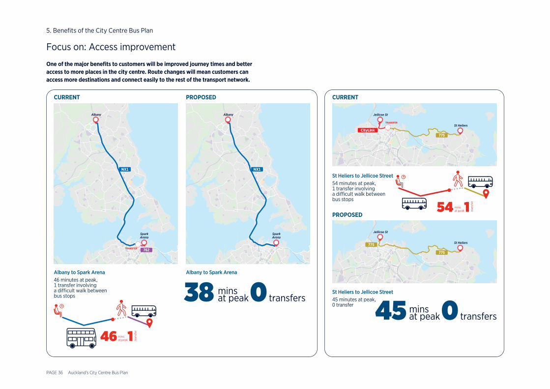
Focus on: Access improvement
One of the major benefits to customers will be improved journey times and better access to more places in the city centre. Route changes will mean customers can access more destinations and connect easily to the rest of the transport network.
TRANSFER
Spark Arena
Albany
CURRENT
Albany to Spark Arena46 minutes at peak,1 transfer involving a difficult walk between bus stops
Spark Arena
Albany
Albany to Spark Arena
PROPOSED
38 mins at peak0 transfers
46 mins at peak1 tr
ansf
er
St Heliers
Jellicoe St
PROPOSED
St Heliers to Jellicoe Street45 minutes at peak,0 transfer
St HeliersTRANSFER
Jellicoe St
St Heliers to Jellicoe Street54 minutes at peak,1 transfer involving a difficult walk between bus stops
CURRENT
45 mins at peak0 transfers
54 mins at peak1 tr
ansf
er
5. Benefits of the City Centre Bus Plan

PAGE 37
2021 20252023 20272022 20262024 2028
Release of The City Centre
Bus Plan
Aotea Station open as part of the
City Rail Link project
We propose a phased approach to deliver this plan. This includes some immediate improvements, while we continue to progress towards the longer-term plan, fitting in with other projects in the city centre.
6.Delivery timeframes
Phase 1• Improved bus priority and improvements to existing stops on Customs Street
and Wellesley Street• Secure land for off-street facilities at Wynyard Quarter• Send Tāmaki Drive services to Wynyard Quarter• Delivery of high-quality bus improvements on Wellesley Street in time for the
opening of the CRL Aotea Station
Phase 2• Construction of dedicated off-street facilities with
high-quality waiting environments• Secure land for off-street facilities at Beach Road/
Learning Quarter• Secure land for off-street facilities at Wynyard Quarter
and explore options in Downtown
Phase 3• Complete delivery of
off-street bus facilities• Extend services across the city centre,
improving passenger journey times• Delivery of off-street facilities at
Beach Road/Learning Quarter• Continuous bus lanes along Customs
Street and Wellesley Street
Delivery of Business Case

PAGE 38
Header
J006576_09.07.21