city of grande prairie bylaw c-1407 a bylaw to adopt the
TRANSCRIPT

CITY OF GRANDE PRAIRIE
BYLAW C-1407
A Bylaw to Adopt the
Avondale High School Sites Area Redevelopment Plan
THE MUNICIPAL COUNCIL OF THE CITY OF GRANDE PRAIRIE, IN THE
PROVINCE OF ALBERTA, DULY ASSEMBLED ENACTS AS FOLLOWS:
1. This Bylaw shall be called the “Avondale High School Sites Area Redevelopment Plan”
Bylaw.
2. The Avondale High School Sites Area Redevelopment Plan, attached as Appendix “A”, is
hereby adopted pursuant to Section 634 of the Municipal Government Act, RSA 2000,
Chapter M-26.
3. This Bylaw shall take effect on the date it is passed.
READ a first time this day of , 2021.
READ a second time this day of , 2021.
READ a third time and finally passed this day of , 2021.
Mayor
City Clerk

Table of Contents 1. Acknowledgements ............................................................................................................................................... 1 2. Introduction ........................................................................................................................................................... 2
2.1. Background .................................................................................................................................................. 2 2.2. Purpose of the Plan ...................................................................................................................................... 2
3. Vision ...................................................................................................................................................................... 3 4. Engagement Process .............................................................................................................................................. 3 5. Legislative and Policy Context ............................................................................................................................... 4
5.1. Municipal Government Act .......................................................................................................................... 4 5.2. Education Act ............................................................................................................................................... 5 5.3. Municipal Development Plan ....................................................................................................................... 5 5.4. Land Use Bylaw ............................................................................................................................................ 7 5.5. Council Strategic Plan 2019-2022 ................................................................................................................ 8 5.6. Non-Statutory Master Plan .......................................................................................................................... 8 5.7. Statement of Compliance............................................................................................................................. 9
6. Plan Area ................................................................................................................................................................ 9 6.1. Location and Context ................................................................................................................................... 9 6.2. History ........................................................................................................................................................ 10 6.3. Existing Development ................................................................................................................................ 10 6.4. Current Ownership and Legal Descriptions ................................................................................................ 11
7. Infrastructure ....................................................................................................................................................... 11 7.1. Roads and Transportation .......................................................................................................................... 11 7.2. Stormwater ................................................................................................................................................ 12 7.3. Water ......................................................................................................................................................... 12 7.4. Wastewater ................................................................................................................................................ 13
8. Land Use Concepts ............................................................................................................................................... 13 8.1. Short-Term Land Use Concept ................................................................................................................... 13 8.2. Medium-Term Land Use Concept .............................................................................................................. 15 8.3. Long-Term Land Use Concept .................................................................................................................... 16 8.4. Alternate Land Use Concept ...................................................................................................................... 17
9. Implementation ................................................................................................................................................... 17 9.1. Overview .................................................................................................................................................... 17 9.2. Lot Lines Reconfiguration ........................................................................................................................... 18 9.3. Potential Road Projects .............................................................................................................................. 18 9.4. Stormwater Management Projects ............................................................................................................ 19 9.5. Site Servicing .............................................................................................................................................. 19 9.6. Trees ........................................................................................................................................................... 19 9.7. Sidewalks and Trails ................................................................................................................................... 19 9.8. Transit ........................................................................................................................................................ 20 9.9. Architectural Controls ................................................................................................................................ 20
List of Maps
Map 1 Plan Area Map 2 Land Ownership Map 3 Existing Roads Map 4 Stormwater Map 5 Water Map 6 Wastewater Map 7 Short-Term Land Use Concept Map 8 Medium-Term Land Use Concept Map 9 Long-Term Land Use Concept Map 10 Trees Map 11 Trails Map 12 Current Transit Map 7A Alternate Short-Term Land Use Concept Map 8A Alternate Medium-Term Land Use Concept Map 9A Alternate Long-Term Land Use Concept

Avondale High School Sites Area Redevelopment Plan Bylaw C-1407
The City of Grande Prairie Page 1
1. Acknowledgements The City would like to thank the following people for their participation in the creation of this ARP: Shane Mudryk - BILDGP Karna Germsheid - GP Sport Connect Krista Schuett - Grande Prairie Regional Recreation Committee Brad Vall - Aquatera Geoff Barron - GPPSD Lynn Dreidger - GPPSD Andre Ouellette - GPPSD Sandy McDonald - GPPSD John Lehners - GPPSD Norm Guindon - GPPSD Davis Michaels - PWPSD Bob Stewart - PWPSD Darren Young - PWPSD Bill Given - City Council Dylan Bressey - City Council Wade Pilat - City Council Joe Johnson Reed des Roches Karen McGriskin Katie Biberdorf Alison Downing Ashley Colter Richard Sali Lindsey Juniper All the residents and landowners who participated in our engagement sessions.

Avondale High School Sites Area Redevelopment Plan Bylaw C-1407
The City of Grande Prairie Page 2
2. Introduction 2.1. Background 2.1.1 The Avondale High School Sites Area Redevelopment Plan (ARP) area is located at the north end
of the Avondale neighbourhood in the City of Grande Prairie (City). It currently contains two high schools; the Grande Prairie Composite High School, owned by the Grande Prairie Public School Division (GPPSD); and the Peace Wapiti Academy (PWA), owned by the Peace Wapiti Public School District (PWPSD). The plan area also contains the Leisure Centre, a City-owned recreation complex that included a 25-metre swimming pool, fitness room and indoor soccer field. The pool and fitness area were closed in 2010 when the Eastlink Centre, the City’s new recreation facility on 68 Avenue, was opened. The Grande Prairie Soccer Centre, comprised of an indoor soccer field, is located directly north of the Leisure Centre.
2.1.2 In 2017 the Province approved funding for a new high school to replace the Composite High
School. As a result, the GPPSD signaled its intent to demolish the Composite High building once the new high school is complete.
2.1.3 In addition, the PWPSD announced that it was seeking to build a new high school somewhere in
the County and that it would vacate the PWA building at that time. Reuse of the PWA building is expected but the future user is unknown it this time.
2.1.4 An assessment of the Leisure Centre structure found that over time the high humidity in the
natatorium and inadequate ventilation had caused significant structural degradation necessitating demolition of that portion of the building. The indoor soccer field part of the building was not negatively affected and remains sound.
2.1.5 The City and GPPSD intend to partner to demolish both the Composite High School and part of
the Leisure Centre at the same time. Demolition of these facilities provides the City and school divisions with the opportunity to review the future use of the area and identify possibilities for infill redevelopment. In 2019 City Council (Council) gave direction to prepare an Area Redevelopment Plan for the area.
2.2. Purpose of the Plan 2.2.1 With the Composite High School and a large portion of the Leisure Centre both scheduled for
demolition it is important that the opportunities for redevelopment and intensification in the plan area be explored. It is also important that the future use of those sites is compatible with the adjacent residential neighbourhood and meet the needs of the community.
2.2.2 This ARP is intended to establish a vision for the future use of the plan area.

Avondale High School Sites Area Redevelopment Plan Bylaw C-1407
The City of Grande Prairie Page 3
3. Vision 3.1 The vision for this ARP is based on engagement with both landowners in the plan area and the
public. A visioning session was held with landowners in October of 2019 and a public engagement session was held in December of 2019. The landowner session identified guiding principles in a number of categories, such as land use, transportation and public space. The public session asked attendees what they like about the neighbourhood, how they used the land in the plan area, and what changes or improvements they would like to see.
3.2 The results from both sessions were reviewed, consolidated and formed the vision for this ARP. 3.3 It is the intent of this ARP to achieve the following:
a) Protect public open spaces and the environment; b) Enhance the transportation network for both vehicles and pedestrians; c) Accommodate a new indoor recreation facility for the north side of the City; and d) Support infill development in the long term.
4. Engagement Process 4.1 A multi-phase engagement plan was used
to ensure that surrounding landowners, the general public and other stakeholders were able to provide meaningful input at targeted stages in the process of developing this ARP.
4.2 The engagement process included:
a) In-person interviews with stakeholders as part of the technical review;
b) A Visioning Session and mini-design charrette with plan area landowners and targeted City administration;
c) An initial public engagement session using a drop-in format open house to gather input from the residents of the Avondale neighbourhood, and wider public, about how they use the area, and their priorities for its future; and

Avondale High School Sites Area Redevelopment Plan Bylaw C-1407
The City of Grande Prairie Page 4
d) A second public engagement session using a by-registration open house format held over two evenings. Its purpose was to show Avondale residents and the public the draft land use concepts that were developed for the plan area, and to get feedback on those concepts. An online Zoom session was also provided for anyone who was unable to attend in person.
4.3 Avondale landowners and the public were notified of these
engagement sessions with letters, ads and press releases. 4.4 The Engage Grande Prairie webpage was used to inform
residents of the project status, provided information about the land use concepts and provided a link to register for the November 2020 engagements sessions.
A summary of the engagement sessions and their date are below.
Landowner discussions regarding property lines September 2019
Visioning Workshop / Mini-Charrette with Landowners & City admin. November 2019
Public Engagement Session #1 December 2019
Landowner engagement to review preliminary land use concepts February 2020
Public Engagement Sessions #2 - Review draft land use concepts November 2020
Public Engagement Session #3 - Review Final Draft of the ARP March 2021
Council Public Hearing March 22, 2021
5. Legislative and Policy Context 5.1. Municipal Government Act 5.1.1 In Alberta municipal land use planning is authorized by the Municipal Government Act - RSA
2000, Chapter M-26 (MGA). This Bylaw has been prepared and adopted as an Area Redevelopment Plan in accordance with the requirements of Section 634 of the MGA. Section 634 of the MGA gives municipalities the authority to designate an area as a redevelopment area for any or all of the following purposes:
a) Preserving or improving land and buildings in the area; b) Rehabilitating buildings in the area; c) Removing buildings from the area; d) Constructing or replacing buildings in the area; e) Establishing, improving or relocating roads, public utilities or other services in the area; and f) Facilitating any other development in the area.
5.1.2 Section 635 of the MGA stipulates the contents of area redevelopment plans. They must describe:
a) the objectives of the plan and how they are to be achieved;

Avondale High School Sites Area Redevelopment Plan Bylaw C-1407
The City of Grande Prairie Page 5
b) the proposed land uses in the plan area; c) any proposals for the acquisition of land for municipal use, school use, parks and recreation
use or any other use that Council considers necessary; and d) the reasons for imposing a redevelopment levy if one is being proposed.
5.1.3 The process for preparing and adopting an ARP is also prescribed in Section 635 of the MGA.
The planning process must include providing opportunities for landowners, the public, school boards and other affected parties to make suggestions and provide input during the planning process. Council must also hold a public hearing in accordance with Section 230 of the MGA before adopting an ARP. The date, time, location, etc. of the public hearing must be advertised in accordance with Section 606 of the MGA.
5.2. Education Act 5.2.1 The Disposition of Property Regulation86/2019 establishes requirements and procedures for the
sale of lands that School Districts deem to be surplus.
5.3. Municipal Development Plan 5.3.1 Section 638 of the MGA requires that all statutory plans be consistent with each other.
Therefore, this ARP must be consistent with the Municipal Development Plan (MDP) Bylaw C-1237.
5.3.2 The entire ARP area is designated
Public Service / Institutional in the MDP. The proposed institutional and recreation uses are consistent with this designation. The proposed commercial and multi-family uses in the Long-Term Concept Plan will require future amendment to the MDP. It is recommended that the MDP be amended once specific commercial and/or residential development is proposed.
5.3.3 Section 3 of the MDP contains a
vision statement for the City, as well as guiding principles to direct MDP policies so that the vision for the City can be achieved. Two of these guiding principles are relevant to the preparation of this ARP. They are:

Avondale High School Sites Area Redevelopment Plan Bylaw C-1407
The City of Grande Prairie Page 6
Guiding Principle 5 5.3.4 Enhance and sustain our existing neighbourhoods by promoting redevelopment that embraces
their character and by providing required infrastructure and community support services. Guiding Principle 14 5.3.5 Encourage community and stakeholder collaboration in development decisions and make
development decisions predictable, fair and cost effective. 5.3.6 In addition to the guiding principles, the MDP contains several policies that further support
appropriate and compatible infill development within established residential neighbourhoods. They are:
Section 4.4 - Infill Development 5.3.7 Council supports infill residential and commercial development where appropriate on vacant or
underutilized parcels of land in established areas, particularly along transit routes. Section 6.1 - Residential Infill in Established Neighbourhoods 5.3.8 It is Council’s intention to encourage residential infill and intensification in established
neighbourhoods pursuant to a Direct Control District process. In considering such proposals, Council shall have regard for the following:
a) sufficiency of infrastructure capacity; b) compatibility in height, scale, and design of other buildings in the neighbourhood; c) respectful of continuity with the streetscape; d) compatibility with surrounding land uses; e) appropriately landscaped; f) adequacy of parking; g) respectful of historical or architectural significance of buildings; and h) consideration of the public interest.
Section 6.3 - Area Redevelopment Plans 5.3.9 Where an ARP is deemed appropriate, Council shall require that Terms of Reference be
prepared for an ARP specific to a mature neighbourhood that is sensitive to and recognizes the character and unique needs of each neighbourhood. Council expects each ARP, as a community-based planning process, to consider the opportunities and potential for infill and intensification. The ARP shall comply with the requirements of the MGA and the Terms of Reference described in Policy 15.8 of this Plan. An ARP will generally address:
a) vision and neighbourhood character; b) proposed land uses and densities; c) development standards; d) architectural design standards;

Avondale High School Sites Area Redevelopment Plan Bylaw C-1407
The City of Grande Prairie Page 7
e) parks, open space and landscaping; f) circulation and streetscape; g) infrastructure and community service capacities; and h) redevelopment levies.
Section 15.8 - Area Redevelopment Plan Requirements 5.3.10 ARPs may be prepared as determined by Council. All ARPs and ARP amendments shall include,
amongst other items:
a) neighbourhood public participation; b) transportation, including noise attenuation requirements; c) provision of public transit services; d) servicing infrastructure and capacities; e) recreation and open space; f) redevelopment levies; g) architectural controls; h) neighbourhood population and housing types; i) school and school population; j) the identification and protection of sustainable locally significant natural features; k) the identification of heritage sites and resources and a strategy to deal with heritage
features; l) a detailed statement addressing compliance with the MDP; m) rationale for amendments to existing ARPs; and n) other topics deemed appropriate by the Approving Authority.
5.4. Land Use Bylaw 5.4.1 The MGA requires the City
adopt a Land Use Bylaw (LUB) Bylaw C-1260. The LUB is the regulatory mechanism the City uses to achieve the visions, objectives and policies contained in the MDP, area structure plans, and area redevelopment plans, that the City has adopted for specific areas.
Land Use Zoning 5.4.2 The LUB regulates the use
and development of land within the City. The LUB divides the City into a number of land use districts. It also contains regulations to ensure that development occurs in an orderly manner.

Avondale High School Sites Area Redevelopment Plan Bylaw C-1407
The City of Grande Prairie Page 8
5.4.3 At the time of adoption of this ARP the entire plan area land is zoned PS - Public Service District. The existing schools, recreation facility and sports field uses are consistent with the PS zoning.
5.4.4 Three (3) lots, also zoned PS, are located to the south. They are the site of the new Composite
High School that will replace the existing Composite High School. The area to the west is also PS. 5.4.5 The areas to the east and south are designated RR - Restricted Residential, to accommodate
single detached housing. Four (4) lots abutting the northeast corner of the plan area are zoned RG - General Residential and contain semi-detached dwellings.
5.4.6 The area to the north, across 116 Avenue, is zoned CA - Arterial Commercial.
5.5. Council Strategic Plan 2019-2022 5.5.1 This ARP aligns with several Results Definitions in Council’s Strategic Plan 2019-2022. These
include:
a) Offers access to a wide range of quality leisure, athletic and recreational activities and opportunities through a network of well-managed, inviting, well-kept and secure indoor and outdoor venues, that fit the needs and wants of the community;
b) Encourages and supports well-planned, sufficiently regulated and appropriately balanced development, redevelopment and community revitalization that stimulates economic growth within Grande Prairie;
c) Support infrastructure development to enhance community and economic development growth;
d) Promotes a communication strategy that actively engages residents and stakeholders to ensure community needs are considered and incorporated into decision making;
e) Engages in both near and long-range planning to ensure the community’s future needs are always considered;
f) Designs, develops and enhances safe, well-maintained, accessible, open spaces, parks, trails, recreational, cultural and other municipal facilities; and
g) Establishes and maintains constructive relations with other governing authorities in the regions including municipalities, First Nations and School Boards.
5.6. Non-Statutory Master Plans 5.6.1 The City has adopted several non-statutory master plans to assist in carrying out its
administrative functions. With regard to the preparation of this ARP, the relevant non-statutory master plans that have been reviewed include:
a) Joint Recreation Master Plan (2016); b) Transportation Master Plan (2020); c) Storm Drainage Master Plan (2018); and d) Traffic Noise Monitoring Program (2020).

Avondale High School Sites Area Redevelopment Plan Bylaw C-1407
The City of Grande Prairie Page 9
5.7. Statement of Compliance 5.7.1 This ARP conforms to the requirements identified in Section 15.8 of the MDP. 5.7.2 The implementation of architectural controls for the commercial and multi-family residential
areas of the long-term land use planning area is premature and should be undertaken as part of the rezoning process when that area is ready to be developed.
5.7.3 The implementation of a redevelopment levy is not considered necessary for this ARP. Section
647 of the MGA allows the City to collect a redevelopment levy for the purposes of providing land for a park or land for school buildings for the instruction or accommodation of students; or land for new or expanded recreation facilities, or both. In the short term the entire plan area will be used for schools and open space, therefore additional recreation land is not required. In the long term when the PWA school is no longer required it will be surplus and available for redevelopment.
6. Plan Area
6.1. Location and Context 6.1.1 The plan area is in the northwest corner of the Avondale neighbourhood as shown on Map 1.
This established single detached residential neighbourhood is located directly to the east and south. That area is zoned RR - Restricted Residential, which limits development to single detached dwellings.
6.1.2 The adjacent
land to the west is owned by the Province of Alberta and contains the Alberta Alcohol and Drug Abuse Commission Northern Addictions Centre.

Avondale High School Sites Area Redevelopment Plan Bylaw C-1407
The City of Grande Prairie Page 10
6.1.3 The north boundary of this ARP area is 116 Avenue. The width of the 116 Avenue right-of-way and the large volume of traffic provides a significant barrier between the plan area and the commercial development on the north side of 116 Avenue.
6.1.4 The new Composite High School is being constructed on the south side of 112 Avenue, directly
south of the plan area. 6.1.5 The plan area is also close to the Grande Prairie Regional College and the new Grande Prairie
Regional Hospital. Both are significant employment and activity generators. The plan area is also close to Muskoseepi and Maskwoteh Parks. Both are part of a major active transportation corridor and provide significant natural greenspace.
6.2. History 6.2.1 The Avondale area was annexed into the City in 1954 as part of a larger annexation area. It was
not until November 1966 that the area was first subdivided from the NW 26-71-6-6 by Plan of Subdivision 4263NY.
6.2.2 New property lines were established in the area in December of 1977 with the registration of
Plan of Subdivision 772 2975. The new property lines created by that subdivision established the lots containing the Composite High School, the Leisure Centre and the PWA.
6.2.3 The Grande Prairie Composite High School was built on Lot 13, Block 6, Plan 4263NY in 1964,
with additions built in 1969, 1975, 1986, 1998, 1999 and 2001 (Alberta Infrastructure 2006 Evaluation Report). The Leisure Centre was built in 1975.
6.2.4 The Soccer Centre was opened in 2000. 6.2.5 The PWA was constructed in 1966. It underwent a modernization in 2002 when it was
transferred from the Catholic School District to the PWPSD (Alberta Infrastructure Evaluation Report, 2007).
6.3. Existing Development 6.3.1 The plan area
currently contains two (2) high schools, a closed indoor recreation facility, two (2) indoor soccer fields and paved parking lots. The area also includes several outdoor recreations facilities including:

Avondale High School Sites Area Redevelopment Plan Bylaw C-1407
The City of Grande Prairie Page 11
a) Natural grass football field with irrigation, lighting, bleachers and press box; b) 400 m running track; c) Long jump track; d) Rugby field; e) Pickelball courts with basketball hoops; f) Baseball diamond; and g) Small soccer fields.
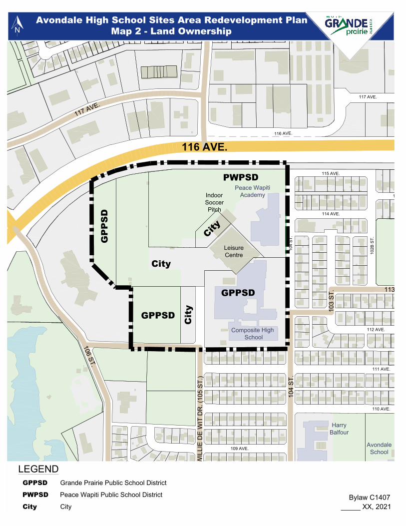
6.4. Current Ownership and Legal Descriptions 6.4.1 The plan area consists of six (6) lots owned by three (3) different owners, as shown on Map 2.
The PWPSD owns Lot 16, the location of the PWA (high school), and part of the soccer centre site. The PWPSD bought this lot from the Grande Prairie Catholic School District in 2002. A caveat on the title of Lot 16 gave the Catholic School District first right to repurchase the lot if the PWPSD no longer needs it. However, that caveat has been discharged.
Legal Description Owner Lot Area Lot 15, Block 6, Plan 772 2975 Grande Prairie Public School District 3.701 ha
Lot 16, Block 6, Plan 772 2975 Peace Wapiti Public School District 5.285 ha
Lot 16A, Block 6, Plan 912 2168 City of Grande Prairie 0.384 ha
Lot 17R, Block 6, Plan 772 2975 City of Grande Prairie 4.075 ha
Lot 18, Block 6, Plan 772 2975 Grande Prairie Public School District 2.632 ha
Lot 20, Block 6, Plan 772 2975 City of Grande Prairie 0.110 ha
6.4.2 The City owns three (3) lots in the plan area; Lot 16A, containing a portion of the soccer centre;
Lot 17R, containing the Leisure Centre and a portion of the football field / running track; and Lot 20, containing a parking lot.
6.4.3 The GPPSD owns two (2) lots; Lot 15, containing the Composite High School; and Lot 18 (which is
in two parts) containing part of the football field / running track and a baseball field. 6.4.4 The current configuration of the existing lot boundaries reflects the approval of subdivisions to
address specific needs that arose over time. However, maintaining the existing lot boundaries may hinder orderly redevelopment within the plan area. Therefore, redrawing the lot boundaries will likely maximize opportunities for redevelopment and benefit the landowners.
7. Infrastructure
7.1. Roads and Transportation 7.1.1 Map 3 shows the existing road network around the plan area. The plan area is bounded on the
north by 116 Avenue, a divided arterial road. A three-way signalized intersection is located at 112 Street and 116 Avenue immediately to the north. However, that intersection does not provide access into Avondale. The nearest accesses to 116 Avenue are currently at 102 Street and at 106 Street. The south side of 116 Avenue includes a noise berm to mitigate traffic sound from the Avondale neighbourhood.

Avondale High School Sites Area Redevelopment Plan Bylaw C-1407
The City of Grande Prairie Page 12
7.1.2 The collector roads providing access to the plan area include 112 and 113 Avenues and 104, 105
and 106 Streets. 7.1.3 The only public road within the plan area is 105 Street, which ends in front of the Composite
High School, and turns into the Leisure Centre parking lot. 7.1.4 The City’s 2020 traffic noise monitoring program placed a residential noise receptor at 10218 -
114A Avenue, a few blocks to the west of the plan area and close to 116 Avenue. It found that the 24-hour average measured sound level at this location was 53.5 dBA, below the 65 dBA limit set out in the 2002 Transportation Master Plan.
7.2. Stormwater 7.2.1 The current stormwater system is shown on Map 4. 7.2.2 Map 7-1 of the Storm Drainage Master Plan (2018) identifies the ARP area as being at medium
flood risk. Section 8.3.2 of that Master Plan contains recommended improvements to the storm drainage system to reduce the flood risk in the area.
7.2.3 In addition, Section 8.3.1 states that upgrading of the ditch on the south side of 116 Avenue
would significantly benefit the Royal Oaks / Northridge areas. This can be accomplished by widening and lowering the ditch as well as upgrading downstream pipes. Widening the ditch would impact the existing asphalt trail located directly to the south of the ditch. Realignment of the trail will be required.
7.2.4 The area is also susceptible to water ponding on the existing sports fields. Maps 7-8 and 7-12 of
that Master Plan show 4-hour and 24-hour onsite ponding. Resolving this may be achieved by regrading and constructing stormwater storage at the south end of the plan area. This may be in the form of a dedicated stormwater holding pond, or by engineering paved parking lots or sports fields to hold stormwater and discharge it back into the stormwater system. The best long-term solution is to use parking lots for stormwater storage as sports fields would be available for use sooner after storm events.
7.3. Water 7.3.1 The water system for the plan area is shown on Map 5. It includes a 300 mm water main under
112 Avenue, 200 mm water lines under 105 Street and the lane south of the Composite High School, and 150 mm water lines under 113 Street. A detailed water servicing study needs to be completed prior to development of an Indoor Recreation Facility, shown in the medium-term land use concept, and prior to commercial or multi-family development, shown on the long-term land use concept.

Avondale High School Sites Area Redevelopment Plan Bylaw C-1407
The City of Grande Prairie Page 13
7.4. Wastewater 7.4.1 The current wastewater system is shown on Map 6. However, Aquatera has identified the need
to upgrade the wastewater system in the area; and has indicated that the preliminary design for the upgrade would be done in 2021, with construction scheduled for 2022. Upcoming upgrades should be done to accommodate future redevelopment.
7.4.2 A detailed wastewater servicing study needs to be completed prior to development of an Indoor
Recreation Facility, shown on the medium-term land use concept, and commercial or multi-family development, shown on the long-term land use concept.
8. Land Use Concepts 8.a This ARP requires a phased approach to redevelopment because not all of the area will be
available for redevelopment at the same time. The Composite High School and Leisure Centre sites will be available for redevelopment within the next two (2) years. It is unknown when the area containing the two (2) indoor soccer facilities will be available. And the PWA site may not be available for redevelopment for 30-50 years.
8.b Orderly redevelopment of the area can and should happen in phases. To reflect this phased
approach to redevelopment this ARP contains short-term, medium-term and long-term land use concepts.
8.1. Short-Term Land Use Concept 8.1.1 Map 7 shows the short-term land use concept for the area. It is based on the Composite High
School and the swimming pool portion of the Leisure Centre being demolished, likely by 2023. 8.1.2 The features of the Short-Term Land Use Concept include: Recreation and Open Space 8.1.3 Upon demolition of the existing Composite High School and most of the Leisure Centre it is
recommended that sports fields be developed in their place. The new Composite High School is being built on three (3) former sports fields. It is necessary that these be replaced, as they provided phys. ed. space for the high school and recreation space for wider community. Although the land use concept shows the sports fields as soccer fields, stakeholders have identified that these fields need to be multi-purpose to best meet the needs of the high schools and other users, which this ARP supports.
8.1.4 The existing natural turf football field, running track and pickleball courts are to be retained. The
area between the pickleball courts and the realigned 112 Avenue can be used to increase the number of courts, accommodate other outdoor recreation amenities, such as a high-board hockey rink, or be kept as multi-purpose open space.

Avondale High School Sites Area Redevelopment Plan Bylaw C-1407
The City of Grande Prairie Page 14
8.1.5 In the short-term the existing indoor soccer facilities also remain. Their condition has been evaluated and with regular maintenance they can continue to be used for several years.
Roads and Transportation 8.1.6 It is recommended that 112 Avenue in front of the new Composite High School be realigned
further to the north, and that this be completed before the new Composite High School opens. Realigning 112 Avenue has three (3) benefits:
a) First, the existing intersection with 106 Street is not at a 90-degree angle. Realigning 112
Avenue would allow this intersection to be at a 90-degree angle, which is optimal for intersection safety;
b) Second, it would allow for the creation of a large on-site parking lot for the new high school; and
c) Third, the east end of 112 Avenue currently lines up with the lane located directly south of the existing Composite High School site. Vehicles are using this lane as a short-cut to get to and from 116 Avenue. Landowners in the area have stated that this is both a nuisance and a safety hazard. Realigning 112 Avenue would reduce the benefit of using this shortcut.
8.1.7 Although the existing Composite High School is to be demolished it is recommended that a
portion of the existing parking lot immediately south of the PWA be retained for the use of the PWA, and potentially public users of the sports fields.
8.1.8 The Short-term Land Use Concept shows recommended trail improvements. These include:
a) realignment of the trail along 116 Avenue where it is impacted by widening the ditch; b) constructing a new trail on 105 Street from 108 Avenue to 116 Avenue; and c) constructing a new trail (or wide sidewalk) in the realigned 112 Avenue from 105 Street to
106 Street. Other Infrastructure 8.1.9 Stormwater management in the area would be improved by widening and lowering the abutting
ditch on the south side of 116 Avenue, as this would increase its stormwater capacity. 8.1.10 Additional stormwater storage capacity at the south end of the plan area can also be created by
engineering the proposed sports fields to act as a stormwater holding area. Education 8.1.11 The PWA building and grounds make up a significant portion of the plan area. The PWA is
currently the County public high school. However, it is a goal of the PWPSD to build a new high school closer to the County’s growing population. Until a replacement high school is funded by the Province and built the PWA will continue to be used as the PWPSD high school. Timing of a new PWPSD high school to replace the PWA is unknown.

Avondale High School Sites Area Redevelopment Plan Bylaw C-1407
The City of Grande Prairie Page 15
8.1.12 However, once a replacement high school has been built the existing building may not be surplus, and the site not available for immediate redevelopment. Depending on the needs of the other local school districts the building and site may be transferred to a different school district for their use. As a result, the timing of redevelopment in that area is uncertain.
8.1.13 The continued operation of the PWA building as a school, either by the PWPSD or another
school district, affects the use of the surrounding land because any school will continue to require sports fields. In the short-term no changes to the Peace Wapiti Academy site are proposed.
8.2. Medium-Term Land Use Concept 8.2.1 The medium-term Land Use Concept is shown on Map 8. The medium-term begins with the
demolition of the soccer centre and the indoor soccer field in the remnant of the Leisure Centre. 8.2.2 The features of the medium-term land use concept are: Recreation and Open Space
a) In the medium-term the two high schools in the area will continue to require sports fields for phys. ed. and other recreational uses. Eventual demolition of the soccer centre and the remainder of the indoor soccer field portion of the Leisure Centre will provide additional space for new sports fields. Therefore, it is recommended that sports fields be developed to the east of 105 Street as shown on Map 8;
b) Demolition of both indoor soccer facilities creates a demand for replacement indoor soccer fields. The medium-term land use concept shows a potential indoor recreation facility in the southeast corner of the ARP area, with the parking lot directly to the west, adjacent to 105 Street. At that location a facility provides a buffer between the residential area to the east and the outdoor activities to the west. The parking lot can also be engineered for stormwater storage;
c) The outdoor recreation amenities on the west side of 105 Street (football field, running track, etc.) remain in the medium term;
Roads and Transportation
d) Prior to the City building a new indoor recreation facility a traffic study should be completed; and
Education
e) The PWA building remains in use through the medium-term.

Avondale High School Sites Area Redevelopment Plan Bylaw C-1407
The City of Grande Prairie Page 16
8.3. Long-Term Land Use Concept 8.3.1 The long-term Land Use Concept is shown on Map 9. It shows the proposed lands uses in the
plan area once the PWA building is no longer on the site. PWA building is currently in very good condition. As a result, it is unknown when the PWA site will be available for redevelopment. But it is likely that transition from the medium-term land uses to the long-term land uses is decades away.
Commercial 8.3.2 The commercial area shown in the long-term land use concept is envisioned to be approximately
0.70 ha in area. This is large enough to accommodate the development of a neighbourhood convenience centre containing uses such as a convenience store, hair and nail salon, etc. It would require vehicle access from 116 Avenue.
Medium Density Residential 8.3.3 This area, approximately 2.5 ha in area, is intended for the development of medium density
housing. Acceptable forms of development include townhouses and four-storey walk-up apartment buildings. In order to facilitate medium density development this ARP supports rezoning the site from PS - Public Service District to a land use district that allows walk-up apartments and townhouses once the land is available for redevelopment and in accordance with the servicing and transportation studies that would be required at that time.
8.3.4 The appropriate districts in the current LUB include the RM - Medium Density Residential
District, the RT - Residential Transition District, and the RC - Combined Residential District. The RM District allows for the development of four-storey apartment buildings with a maximum density of 94 units per ha and multi-attached development (side-by-side and up-down townhouses) with a density of approximately 40 units per ha.
8.3.5 The RT District allows low rise apartment buildings and multi-attached developments up to eight
units in size; while the RC District allows for low to medium density residential development up to 12-unit apartment buildings and 10-unit multi-attached dwellings.
8.3.6 Over time the City may adopt a new LUB with different district names and initials. However, it is
the intent of this ARP that medium density residential development in the form of townhouses and low-rise apartment building up to four storeys in height, be approved within this area, regardless of the district name.
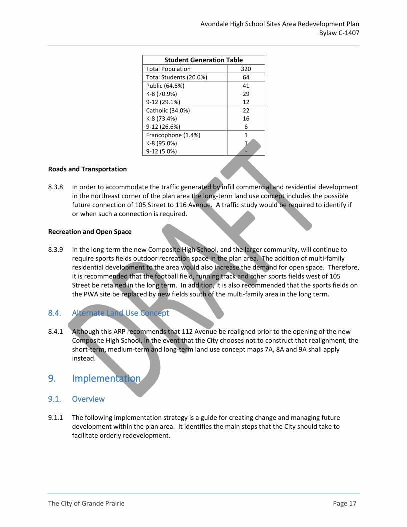
8.3.7 At 80 units per ha the site could accommodate a maximum of approximately 200 dwelling units.
At an average of 1.6 people per dwelling unit for apartments the area could accommodate approximately 320 people.
Avondale High School Sites Area Redevelopment Plan Bylaw C-1407
The City of Grande Prairie Page 17
Student Generation Table
Total Population 320
Total Students (20.0%) 64
Public (64.6%) K-8 (70.9%) 9-12 (29.1%)
41 29 12
Catholic (34.0%) K-8 (73.4%) 9-12 (26.6%)
22 16 6
Francophone (1.4%) K-8 (95.0%) 9-12 (5.0%)
1 1 -
Roads and Transportation 8.3.8 In order to accommodate the traffic generated by infill commercial and residential development
in the northeast corner of the plan area the long-term land use concept includes the possible future connection of 105 Street to 116 Avenue. A traffic study would be required to identify if or when such a connection is required.
Recreation and Open Space 8.3.9 In the long-term the new Composite High School, and the larger community, will continue to
require sports fields outdoor recreation space in the plan area. The addition of multi-family residential development to the area would also increase the demand for open space. Therefore, it is recommended that the football field, running track and other sports fields west of 105 Street be retained in the long term. In addition, it is also recommended that the sports fields on the PWA site be replaced by new fields south of the multi-family area in the long term.
8.4. Alternate Land Use Concept 8.4.1 Although this ARP recommends that 112 Avenue be realigned prior to the opening of the new
Composite High School, in the event that the City chooses not to construct that realignment, the short-term, medium-term and long-term land use concept maps 7A, 8A and 9A shall apply instead.
9. Implementation
9.1. Overview 9.1.1 The following implementation strategy is a guide for creating change and managing future
development within the plan area. It identifies the main steps that the City should take to facilitate orderly redevelopment.

Avondale High School Sites Area Redevelopment Plan Bylaw C-1407
The City of Grande Prairie Page 18
9.2. Lot Lines Reconfiguration 9.2.1 The existing lot lines within the plan area reflect the development history of the area. However,
the potential for redevelopment in the area would benefit from replotting the property lines to rationalize future development areas and simplify land ownership and land use district boundaries.
9.3. Potential Road Projects Short Term - 112 Avenue Realignment 9.3.1 It is recommended that 112 Avenue in front of the new Composite High School be realigned
further to the north, and that this be completed before the new Composite High School opens. Realigning 112 Avenue has three (3) benefits:
a) First, the existing intersection with 106 Street is not at a 90-degree angle. Realigning 112
Avenue would allow this intersection to be at a 90-degree angle, which is optimal for intersection safety;
b) Second, it would allow for the creation of a large on-site parking lot for the new high school; and
c) Third, the east end of 112 Avenue currently lines up with the lane located directly south of the existing Composite High School site. Vehicles are using this lane as a short-cut to get to and from 116 Avenue.
9.3.2 Realigning 112 Avenue would reduce the benefit of using this shortcut. 9.3.3 Realigning 112 Avenue would require negotiation with the Province because the new alignment
would likely need to cross the provincially owned lot containing the Northern Addictions Centre. Long Term - Connecting 105 Street to 116 Avenue 9.3.4 Development of multi-family housing and commercial development on the PWA lands will
generate additional motor vehicle traffic in the neighbourhood. A traffic impact assessment will be required prior to such development occurring. A traffic study may identify the need to enhance road capacity in area. One way to increase capacity would be to connect 105 Street (Willie deWit Drive) to 116 Avenue. This project would include the construction of approximately 200 metres of road. Construction of this road is estimated to cost approximately $3.5 million - $5.1 million (in 2019 dollars). Addressing the difference in elevation and the existing stormwater ditch along 116 Avenue both factor into the complexity and cost of this road project.
9.3.5 The City may consider it desirable to connect 105 Street to 116 Avenue before the long term if
recommended by a traffic study. In that case the City should ensure that there is sufficient sports field space on the east side of 105 Street so students in the PWA building do not have to cross 105 Street to get to them.
Avondale High School Sites Area Redevelopment Plan Bylaw C-1407
The City of Grande Prairie Page 19
9.4. Stormwater Management Projects 9.4.1 Map 7-1 of the Storm Drainage Master Plan (2018) identifies the plan area as being at medium
flood risk. Section 9.3.2 of that Master Plan includes measures for the City to take to reduce the flood risk in the Avondale area.
9.4.2 A stormwater drainage ditch is located along the south side of 116 Avenue, the northern
boundary of the plan area. Section 8.3.1 of that Master Plan states that upgrading the ditch would provide significant benefit to the Royal Oaks North / Northridge areas. Improvements includes lowering and widening the ditch, as well as upgrades to downstream pipe. Widening the ditch will impact the existing asphalt trail located directly to the south.
9.4.3 The sports fields experience ponding during storm events. This can be mitigated by creating
stormwater storage at the south end of the plan area, either in the sports fields or in paved parking lots. The use of parking lots is the better long-term solution because sports fields would be usable sooner after storms if they are not being used for stormwater storage.
9.5. Site Servicing 9.5.1 Servicing infill development with water and wastewater services will be the responsibility of the
future developer. Maps 8 and 9 show the existing water and wastewater systems. The completion of water and wastewater studies will be required before redevelopment occurs in the area to ensure that there is adequate capacity for new development. The completion of such studies is considered premature at this time because future uses, and the required servicing capacity for such uses, is currently uncertain.
9.6. Trees 9.6.1 Planting more trees and preserving existing trees where possible was identified as a priority with
Avondale residents. The land use concepts recommend a number of road and building construction projects that should include significant tree planting as a priority. Map 10 shows possible locations for new boulevard trees along the realigned 112 Avenue and along the extension of 105 Street to 116 Avenue.
9.6.2 Future tree planting must take into consideration that much of the plan area is intended for
sports fields and active recreation. Trees cannot be placed where they would impede the sports and recreation use of those areas.
9.7. Sidewalks and Trails 9.7.1 A combination of concrete sidewalks and asphalt trails currently accommodate active
transportation to and through the plan area. The existing trails, and the recommended improvements to the trail network, are shown on Map 11. These improvements include:
a) Realignment of the trail along the south side on 116 Avenue to accommodate widening of
the abutting stormwater channel;

Avondale High School Sites Area Redevelopment Plan Bylaw C-1407
The City of Grande Prairie Page 20
b) Construction of a new trail along 105 Street from 108 Avenue to 116 Avenue; and c) Construction of a new trail along the realigned 112 Avenue from 105 Street to 106 Street.
9.8. Transit 9.8.1 The existing transit routes are shown on Map 12. Transit route routinely change over time in
order to optimize service delivery and reflect changing ridership. The City is preparing for a change to the transit service delivery model, which will likely result in changes to existing routes.
9.9. Architectural Controls 9.9.1 Section 15.8 of the MDP requires ARPs to address architectural standards for new development
/ redevelopment in the plan area. However, in this case commercial and residential development are proposed only in the long-term land use concept. As a result, any such development is not likely to occur for decades. Therefore, it is recommended that the implementation of architectural standards occur at the same time the land is being rezoned to allow commercial and multi-family development.

116 AVE.
100
ST.
108
ST.
100 AVE.
128
AVE.
128 AVE.
110
ST.
108 AVE.108 AVE.
103B ST.
96 AVE.
98 AVE.
103 AVE.
112
ST.
112
ST.
101 AVE. (VETERANS WAY)
124 AVE.
97 AVE.
97 AVE.
105 AVE.
99 S
T.
99 S
T.
113 AVE.
106A ST.
104 AVE.
104 AVE.
107 AVE.
103
ST.
DR.
104
ST.
102 AVE.
101
ST.
101
ST.
102
ST.
102
ST.
102
ST.
92 AVE.
117 AVE.
121 AVE.
115 AVE.
109
ST.
105
ST.
WIL
LIE
DE
WIT
DR
. (10
5 ST
.)105 ST.
105 ST.
94 AVE.
106
ST.
106 ST.
99 AVE.
108 ST.108 ST.
108
ST.
100
ST.
100
ST.
98 S
T.98
ST.
99 ST.
116 AVE.
ROYAL OAKS
100 AVE. (RICHMOND AVE.)
128 AVE.
Bear River
Reservoir
Muskoseepi
NAvondale High School Sites Area Redevelopment Plan
Map 1 - Plan Area
Bylaw C1407_______ XX, 2021
116 AVE.
108
ST.
119 AVE.
104
ST.
104
ST.
114A AVE.
112 AVE.
117 AVE.
111 AVE.
106A ST.
116 AVE.
114 AVE.
115 AVE.
105A
ST.
106
ST.
104A ST.
120A AVE.
102B
ST.
110 AVE.
102A
ST.
103
ST.
107 AVE.
106 AVE.
109 AVE.
108 AVE.
113 AVE.
103
ST.
104
ST.
102
ST.
117 AVE.
WIL
LIE
DE
WIT
DR
. (10
5 ST
.)105 ST.
106 ST.
108 ST.
OAKS
IndoorSoccerPitch
LeisureCentre
Reservoir
City
GPPSD
PWPSD
GP
PS
D
Cit
y
GPPSD
City
HarryBalfour
Composite High School
Peace WapitiAcademy
AvondaleSchool
LEGENDGrande Prairie Public School District
Peace Wapiti Public School District
City
Bylaw C1407_____ XX, 2021
GPPSD
PWPSD
City
NAvondale High School Sites Area Redevelopment Plan
Map 2 - Land Ownership

107
ST.
PRIV
ATE
111
ST.
PRIVATE
PRIVATE RD.
109
ST.
109 ST.
PRIV
ATE
PRIVATE
PRIVATE
102 AVE.
106
ST.
PRIVATE
PRIVATEPRIVATE
PRIVATE
104A AVE.
106 AVE.
PRIVATE
104 AVE.
PRIV
ATE
PRIV
ATE
PRIV
ATE
PRIVATE R
D.
116 AVE.
100
ST.
108
ST.
100 AVE.
109
ST.
119 AVE.
129
AVE.
104
ST.
104
ST.
107A
ST.
107A
ST.
114A AVE.
99 S
T.
99 S
T.
99 S
T.
104 AVE.
103A
ST.
103A
ST.
105 ST.
112 AVE.112 AVE.
112 AVE.
110
ST.
117 AVE.
111 AVE.
111 AVE.
99 AVE.99 AVE.
OAK RD.
106A
ST.
106A ST.
106A
ST.
106A ST.
101B
ST.
120 AVE.
103 AVE. 103 AVE.
106 A AVE.
116 AVE.
114 AVE.
125 AVE.
125 AVE.
113
ST.
107
ST.
107
ST.
107
ST.
107
ST.
98 AVE. 98 AVE.
115 AVE.
115 AVE.115 AVE.
126 AVE.
126 AVE.
113 AVE.113 AVE.
113 AVE.
105A
ST.
105 AVE.
127 AVE.
121 AVE.121 AVE.
119A AVE.
124 AVE.
124 AVE.
106
ST.
106
ST.
106
ST.
105A AVE.
103B
ST.
98 S
T.98
ST.
98 S
T.98
ST.
102 AVE.
104A
ST
104A ST.
104A ST.
101A
ST.
101A
ST.
101
ST.
97A
ST.
120A AVE.
94 AVE.
102B
ST.
102B
ST.
128 AVE.
96 AVE. 96 AVE.
122 AVE.
110 AVE.110 AVE.
124A AVE.
95 AVE.
95 AVE.
97 S
T.97
ST.
97 S
T.97
ST.
111
ST.
111
ST.
102A
ST.
102A
ST.
103
ST.
103
ST.
107 AVE.
107 AVE.107 AVE.
106 AVE.106 AVE.
106 AVE.
123 AVE.
101 AVE.101 AVE. 101 AVE.
109 AVE. 109 AVE. 109 AVE.
129A AVE.
128
AVE.
128 AVE.
110
ST.
108 AVE.108 AVE.
103B ST.
96 AVE.
98 AVE.
103 AVE.
112
ST.
112
ST.
101 AVE. (VETERANS WAY)
124 AVE.
97 AVE.
97 AVE.
105 AVE.
99 S
T.
99 S
T.
113 AVE.
106A ST.
104 AVE.
104 AVE.
107 AVE.
103
ST.
DR.
104
ST.
102 AVE.
101
ST.
101
ST.
102
ST.
102
ST.
102
ST.
92 AVE.
117 AVE.
121 AVE.
115 AVE.
109
ST.
105
ST.
WIL
LIE
DE
WIT
DR
. (10
5 ST
.)105 ST.
105 ST.
94 AVE.
106
ST.
106 ST.
99 AVE.
108 ST.
108 ST.
108
ST.
100
ST.
100
ST.
98 S
T.98
ST.
99 ST.
ROYAL OAKS
100 AVE. (RICHMOND AVE.)
128 AVE.
PRIVATE
PRIVATE
PRIVATE
PRIVATE
PRIVATE
PRIVATE
PRIVATE
Bear River
Reservoir
Muskoseepi
NAvondale High School Sites Area Redevelopment Plan
Map 3 - Existing Roads
Arterial Roads
Collector Roads
LEGEND
Bylaw C1407_____ XX, 2021

107
ST.10
9 ST
.
PRIV
ATE
PRIVATE
106
ST.
PRIVATE
PRIVATEPRIVATE
PRIVATE
104A AVE.
106 AVE.
104 AVE.
PRIV
ATE
PRIV
ATE
PRIVATE R
D.
116 AVE.
108
ST.
109
ST.
119 AVE.
104
ST.
104
ST.
107A
ST.
114A AVE.
104 AVE.
103A
ST.
112 AVE.112 AVE.
117 AVE.
111 AVE.
106A ST.
106A ST.
101B
ST.
120 AVE.
103 AVE.
116 AVE.
114 AVE.
107
ST.
115 AVE.
115 AVE.
113 AVE.
105A
ST.
105 AVE.
121 AVE.121 AVE.
124 AVE.
106
ST.
106
ST.
103B
ST.
104A
ST
104A ST.
104A ST.
101A
ST.
120A AVE.
102B
ST.
122 AVE.
110 AVE.110 AVE.
124A AVE.
102A
ST.
103
ST.
107 AVE.
106 AVE.
123 AVE.
109 AVE. 109 AVE.
108 AVE.108 AVE.
113 AVE.
104 AVE.
103
ST.
DR.
104
ST.
101
ST.
102
ST.
102
ST.
117 AVE.
121 AVE.
WIL
LIE
DE
WIT
DR
. (10
5 ST
.)105 ST.
106 ST.
108 ST.
ROYAL OAKS
PRIVATE
PRIVATE
Bear River
Reservoir
NAvondale High School Sites Area Redevelopment Plan
Map 4 - Stormwater
Bylaw C1407_______ XX, 2021

107
ST.10
9 ST
.
PRIV
ATE
PRIVATE
106
ST.
PRIVATE
PRIVATEPRIVATE
PRIVATE
104A AVE.
106 AVE.
104 AVE.
PRIV
ATE
PRIV
ATE
PRIVATE R
D.
116 AVE.
108
ST.
109
ST.
119 AVE.
104
ST.
104
ST.
107A
ST.
114A AVE.
104 AVE.
103A
ST.
112 AVE.112 AVE.
117 AVE.
111 AVE.
106A ST.
106A ST.
101B
ST.
120 AVE.
103 AVE.
116 AVE.
114 AVE.
107
ST.
115 AVE.
115 AVE.
113 AVE.
105A
ST.
105 AVE.
121 AVE.121 AVE.
124 AVE.
106
ST.
106
ST.
103B
ST.
104A
ST
104A ST.
104A ST.
101A
ST.
120A AVE.
102B
ST.
122 AVE.
110 AVE.110 AVE.
124A AVE.
102A
ST.
103
ST.
107 AVE.
106 AVE.
123 AVE.
109 AVE. 109 AVE.
108 AVE.108 AVE.
113 AVE.
104 AVE.
103
ST.
DR.
104
ST.
101
ST.
102
ST.
102
ST.
117 AVE.
121 AVE.
WIL
LIE
DE
WIT
DR
. (10
5 ST
.)105 ST.
106 ST.
108 ST.
ROYAL OAKS
PRIVATE
PRIVATE
Bear River
Reservoir
NAvondale High School Sites Area Redevelopment Plan
Map 5 - Water
Bylaw C1407_______ XX, 2021

107
ST.
PRIV
ATE
PRIVATE
106
ST.
PRIVATE
PRIVATEPRIVATE
PRIVATE
104 AVE.
PRIV
ATE
PRIVATE R
D.
116 AVE.
108
ST.
109
ST.
119 AVE.
104
ST.
104
ST.
107A
ST.
114A AVE.
104 AVE.
103A
ST.
112 AVE.112 AVE.
117 AVE.
111 AVE.
106A ST.
106A ST.
101B
ST.
120 AVE.
116 AVE.
114 AVE.
107
ST.
115 AVE.
115 AVE.
113 AVE.
105A
ST.
105 AVE.
121 AVE.121 AVE.
124 AVE.
106
ST.
103B
ST.
104A
ST
104A ST.
101A
ST.
120A AVE.
102B
ST.
122 AVE.
110 AVE.
124A AVE.
102A
ST.
103
ST.
107 AVE.
106 AVE.
109 AVE. 109 AVE.
108 AVE.108 AVE.
113 AVE.
104 AVE.
103
ST.
DR.
104
ST.
102
ST.
102
ST.
117 AVE.
WIL
LIE
DE
WIT
DR
. (10
5 ST
.)105 ST.
106 ST.
108 ST.
ROYAL OAKS
PRIVATE
PRIVATE
Bear River
Reservoir
NAvondale High School Sites Area Redevelopment Plan
Map 6 - Waste Water
Bylaw C1407_______ XX, 2021

Trails
116 AVE.
104
ST.
112 AVE.
116 AVE.
114 AVE.
115 AVE.
109 AVE.
103
ST.
104
ST.
117 AVE.
WIL
LIE
DE
WIT
DR
. (10
5 ST
.)
106 ST.
115 AVE.
114 AVE.
110 AVE.
111 AVE.
OutdoorRecreation
Area
Sports Fields
Sport Field
SportsField
P
Stormwater
Closed Road
P
P
PPickleball
Courts
High School
Heritage Discovery Centre
School
NAvondale High School Sites Area Redevelopment Plan
Map 7 - Short-Term Land Use Concept
Single Detached HousingMulti-Family HousingCommercial
LEGEND
Bylaw C1407_____ XX, 2021
Institutional and Storm PondsRecreation and Open SpaceParking Roads
Pickleball CourtsTrailStormwater Storage

116 AVE.
104
ST.
116 AVE.
114 AVE.
115 AVE.
109 AVE.
108 AVE.
103
ST.
104
ST.
117 AVE.
WIL
LIE
DE
WIT
DR
. (10
5 ST
.)
106 ST.
PickleballCourts
Trails
OutdoorRecreation
Area
115 AVE.
114 AVE.
110 AVE.
111 AVE.
Sports Fields
P
Sports Field
SportsField
P
PotentialRecreation
Facility
Stormwater
Closed Road
P
P
P
High School
Heritage Discovery Centre
School
Reservoir
NAvondale High School Sites Area Redevelopment Plan
Map 8 - Medium-Term Land Use Concept
Single Detached HousingMulti-Family HousingCommercial
LEGEND
Bylaw C1407_____ XX, 2021
Institutional and Storm PondsRecreation and Open SpaceParking Roads
Pickleball CourtsTrailStormwater Storage

116 AVE.
104
ST.
112 AVE.
116 AVE.
114 AVE.
115 AVE.
102B
ST.
109 AVE.
103
ST.
104
ST.
117 AVE.
WIL
LIE
DE
WIT
DR
. (10
5 ST
.)
106 ST.
PickleballCourts
Trails
OutdoorRecreation
Area
115 AVE.
114 AVE.
110 AVE.
111 AVE.
PotentialRecreation
FacilityP
Sports FieldsP
SportsField
Sports Field
Stormwater
Closed Road
P
P
High School
Heritage Discovery Centre
Reservoir
NAvondale High School Sites Area Redevelopment Plan
Map 9 - Long-Term Land Use Concept
Single Detached HousingMulti-Family HousingCommercial
LEGEND
Bylaw C1407_____ XX, 2021
Institutional and Storm PondsRecreation and Open SpaceParking Roads
Pickleball CourtsTrailStormwater Storage

116 AVE.
119 AVE.
104
ST.
104
ST.
114A AVE.
112 AVE.
117 AVE.
111 AVE.
116 AVE.
114 AVE.
115 AVE.
102B
ST.
110 AVE.
102A
ST.
103
ST.
107 AVE.
109 AVE.
108 AVE.
113 AVE.
103
ST.
104
ST.
117 AVE.
WIL
LIE
DE
WIT
DR
. (10
5 ST
.)
106 ST.
108 ST.
Reservoir
NAvondale High School Sites Area Redevelopment Plan
Map 10 - Trees
Trees
LEGEND Bylaw C1407
_____ XX, 2021

IndoorSoccerPitch
LeisureCentre
HarryBalfour
Composite High School
Peace WapitiAcademy
Reservoir
116 AVE.
119 AVE.
104
ST.
104
ST.
114A AVE.
112 AVE.
117 AVE.
111 AVE.
116 AVE.
114 AVE.
115 AVE.
102B
ST.
110 AVE.
102A
ST.
103
ST.
107 AVE.
109 AVE.
108 AVE.
113 AVE.
103
ST.
104
ST.
117 AVE.
WIL
LIE
DE
WIT
DR
. (10
5 ST
.)
106 ST.
108 ST.
NAvondale High School Sites Area Redevelopment Plan
Map 11 - Trails
Existing Trails
Proposed Trails
LEGEND
Bylaw C1407_____ XX, 2021

116 AVE.
100
ST.
108
ST.
100 AVE.
110
ST.
108 AVE.108 AVE.
103B ST.
98 AVE.
101 AVE. (VETERANS WAY)
124 AVE.
97 AVE.
105 AVE.
99 S
T.
113 AVE.
106A ST.
104 AVE.
104 AVE.
107 AVE.
103
ST.
DR.
104
ST.
102 AVE.
101
ST.
101
ST.
102
ST.
102
ST.
102
ST.
117 AVE.
121 AVE.
115 AVE.10
5 ST
.W
ILLI
E D
E W
IT D
R. (
105
ST.)
105 ST.
105 ST.
106
ST.
106 ST.
99 AVE.
108 ST.
100
ST.
100
ST.
99 ST.
ROYAL OAKS
100 AVE. (RICHMOND AVE.)
Reservoir
Muskoseepi
NAvondale High School Sites Area Redevelopment Plan
Map 12 - Current Transit
Route 2
LEGEND Bylaw C1407
_____ XX, 2021Route 4 Route 6Route 5

Trails
116 AVE.
104
ST.
112 AVE.
116 AVE.
114 AVE.
115 AVE.
109 AVE.
103
ST.
104
ST.
117 AVE.
WIL
LIE
DE
WIT
DR
. (10
5 ST
.)
106 ST.
112 AVE.
HighSchoolParking
115 AVE.
114 AVE.
110 AVE.
111 AVE.
OutdoorRecreation
Area
Sports Field
Sport Field
SportsField
P
Stormwater
PPPickleball
Courts
High School
Heritage Discovery Centre
School
Reservoir
NAvondale High School Sites Area Redevelopment Plan
Map 7A - Alternate Short-Term Land Use Concept
Single Detached HousingMulti-Family HousingCommercial
LEGEND
Bylaw C1407_____ XX, 2021
Institutional and Storm PondsRecreation and Open SpaceParking Roads
Pickleball CourtsTrailStormwater Storage

116 AVE.
104
ST.
116 AVE.
114 AVE.
115 AVE.
109 AVE.
108 AVE.
103
ST.
104
ST.
117 AVE.
WIL
LIE
DE
WIT
DR
. (10
5 ST
.)
106 ST.
PickleballCourts
Trails
112 AVE.
RecreationParking
OutdoorRecreation
Area
115 AVE.
114 AVE.
110 AVE.
111 AVE.
Sports Fields
HighSchoolParking
Sports Field
SportsField
P
PotentialRecreation
Facility
Stormwater
P
P
High School
Heritage Discovery Centre
School
Reservoir
NAvondale High School Sites Area Redevelopment PlanMap 8A - Alternate Medium-Term Land Use Concept
Single Detached HousingMulti-Family HousingCommercial
LEGEND
Bylaw C1407_____ XX, 2021
Institutional and Storm PondsRecreation and Open SpaceParking Roads
Pickleball CourtsTrailStormwater Storage

116 AVE.
104
ST.
112 AVE.
116 AVE.
114 AVE.
115 AVE.
102B
ST.
109 AVE.
103
ST.
104
ST.
117 AVE.
WIL
LIE
DE
WIT
DR
. (10
5 ST
.)
106 ST.
PickleballCourts
Trails
112 AVE.
Fields
RecreationParking
HighSchoolParking
OutdoorRecreation
Area
115 AVE.
114 AVE.
110 AVE.
111 AVE.
PotentialRecreation
Facility
Sports
P
SportsField
Sports Field
Stormwater
P
High School
Heritage Discovery Centre
Reservoir
NAvondale High School Sites Area Redevelopment Plan
Map 9A - Alternate Long-Term Land Use Concept
Single Detached HousingMulti-Family HousingCommercial
LEGEND
Bylaw C1407_____ XX, 2021
Institutional and Storm PondsRecreation and Open SpaceParking Roads
Pickleball CourtsTrailStormwater Storage