city of playford heritage review - envirodata · each historic (conservation) zone or policy area....
TRANSCRIPT
CITY OF PLAYFORD
HERITAGE REVIEW
December 2001
McDougall & Vines ConseJVation and Heritage Consultants
27 Sydenham Road, Norwood, SA, 5067 Phone: (08) 8362 6399 Fax: (08) 8363 0121
Email: mcdvines@bigpond. com

CONTENTS
Page No
1.0 INTRODUCTION 1 1.1 Background 1.2 Study Area 1.3 Objectives of the Study 1.4 History of the Area
2.0 RECOMMENDATIONS OF THE REVIEW 2 2.1 Planning Recommendations
2.1.1 Heritage Plan Amendment Report (PAR) 2.1.2 Other Planning Issues
2.2 State Heritage Places 2.2.1 Current Places on the State Heritage Register 2.2.2 Further Places of State Heritage Value
2.3 Local Heritage Places 2.3.1 Table of Local Heritage Places 2.3.2 Exclusions
2.4 Management Recommendations 2.4.1 Introduction 2.4.2 Staff Training and Development 2.4.3 Heritage Advisory Services 2.4.4 Financial incentives 2.4.5 Education and Information 2.4.6 Community Participation
3.0 ASSESSMENT OF AREAS 13 3.1 Elizabeth South
3.1.1 Previously Identified Historic Conservation Zone 3.1.2 Description of Zone 3.1.3 Significance of the Zone 3.1.4 Recommendations for Elizabeth South
3.2 Early Villages in Playford 3.2.1 One Tree Hill Village Centre 3.2.2 Smithfield Early Village Centre 3.2.3 Virginia Village Centre
3.3 Elizabeth Civic Centre 3.4 Landscape, Topography and Land Use
4.0 ASSESSMENT OF PLACES 16
• PLAYFORD HERITAGE REVIEW • • McDougall & Vines, Conservation and Heritage Consultants, 27 Sydenham Road, Norwood, SA, 5067 •

1.0 INTRODUCTION
1.1 Background
The City of Playford is an amalgamation between the former Councils of Elizabeth and Munno Para. These Councils undertook Heritage Surveys in the late 1990s. The Munno Para Heritage Survey was undertaken by Sarah Laurence and Taylor Weidenhoffer and Associates in 1996 and the City of Elizabeth Heritage Survey was undertaken in 1997 by Danvers Architects.
These surveys evaluated the heritage resources of the former Council areas and recommended a number of places for both State and Local Heritage Listing. Since that time the amalgamated Council of Playford has determined to prepare a Heritage Plan Amendment Report (PAR) in order to include schedules of places of local heritage value in the Development Plan. Consequently this review was undertaken with the intention of reassessing the places recommended in 1996 and 1997.
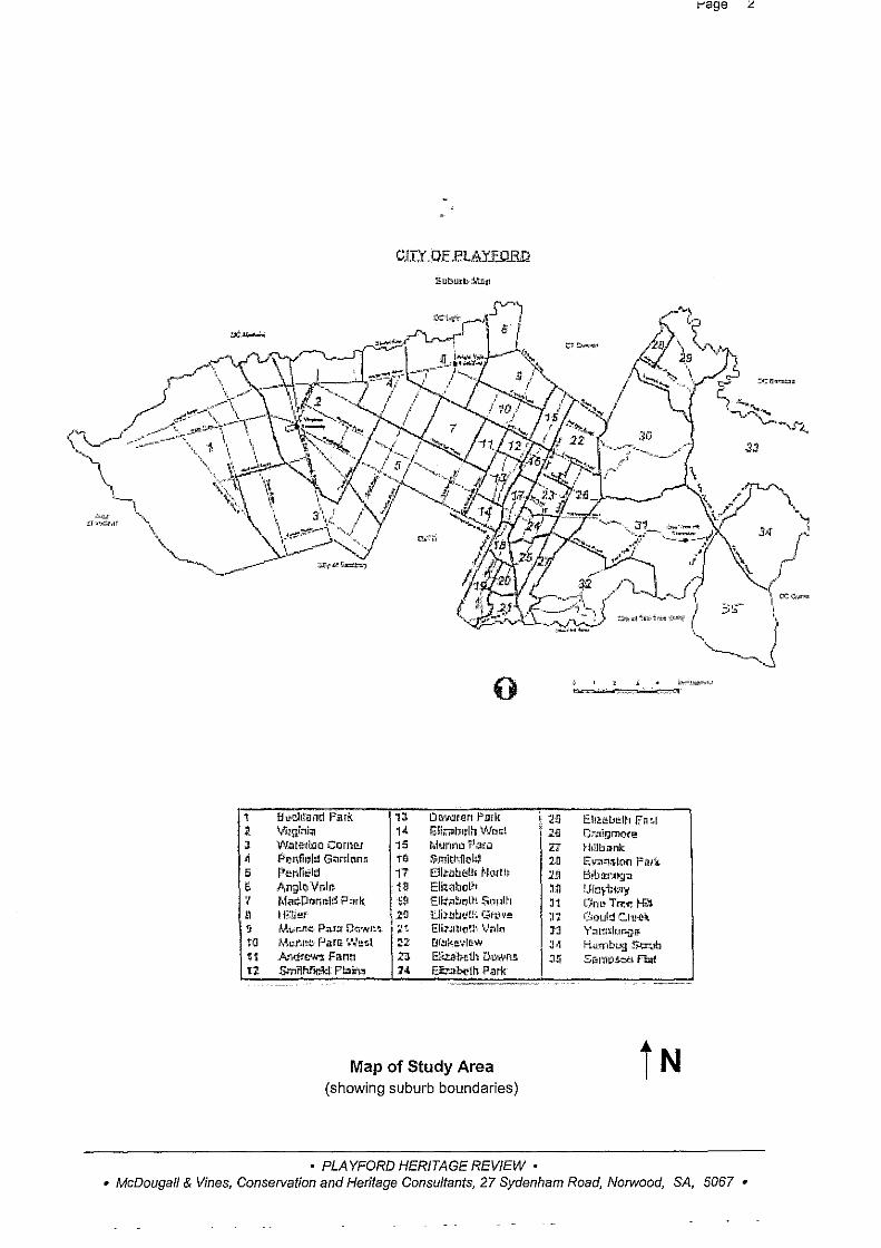
1.2 Study Area (refer following map)
The study area is the City of Playford which is divided into a number of townships and districts and incorporates both the former City of Elizabeth and the former City of Munno Para.
1.3 Objectives of the Study
The objectives of this Review of Heritage Places in the City of Playford is to provide an authoritative description and evaluation of the heritage resources of the area to be used for ongoing conservation planning, Development Application assessment, and to form the basis of a Heritage PAR. Specifically the Review will:
a) provide a list of places of local heritage value clearly stating the relevant criteria under the Development Act for inclusion in the Development Plan.
b) confirm the identification and delineation of areas as Historic (Conservation) Zones or Policy Areas for inclusion in the Development Plan.
c) provide written and graphic advice about the characteristics which are the basis of each Historic (Conservation) Zone or Policy Area. Note that there was only one Historic (Conservation) Zone proposed in the City of Playford area in the previous Heritage Surveys.
1.4 History of the Area
The previous Heritage Surveys have provided a summary history for both the former Council areas which they covered. It is not the intention of this report to provide further overview history, but to use those previously written histories as a basis for assessment of the historical significance of the individual local heritage places.
• PLAYFORD HERITAGE REVIEW • • McDougall & Vines, Conservation and Heritage Consultants, 27 Sydenham Road, Norwood, SA, 5067 •
1 l J ~
5 6 '/ G 3 ta If 1l
0
Biit-::!l!tand Fa~ 13 DC!Ymen F"mk VlJgini:;"J 1< !;lii';'i:lt:n:lh V•ic~>t Wato!:ti.ao Carnrg 15 t.itJ/'uiu 7i3~.J P'c-.n;(h,lt!l G~rclr:mr~ 10 Smitl\flol~ l,.,4!hlield 17 Cllt-llbt!121 Norll~ An;:lcVr.l~ 1~ E!!znbol~t Mac.DanDl:~ ? nrk I ,~ Ell;?:~bolt~ $.1)1Jih .. 1\Wlef \2~ i:.ll.wbo!.!Ut Grove: Mv;r..!lC Pn.rll Q(;•,.,.n"+ l tt Eli7<Uto~h '..,'Nin A~l:J\l!t,:, f'ilra '."~1 !.!t:.l 22. Df.!lkl!'.;lt!<W
A'!\d!'~ Filntl 2:1 E~!-..e1h tJJ.YA~ns. S..ilith?"~ Plain, 14 E:t.abeth Pork
-·
Map of Study Area (showing suburb boundaries)
• PLAYFORD HERITAGE REVIEW •
\ ~11 l~
'll 20 1!l ~n
J1 :11 JJ J< :J~
t-'age L
_.,~ .... ~=-~=-..,..,w
Ell;!:i!:l,~th En 41 C:-.ni!)m(!r!:! }-hllbank E;l{;ltt:;.lcm Ptu\-Ciih:tf'U~:;t Ufer,t4..'1)' On!!Trt:~ 1-G:. Oould C.t !.!~lt. 'r':ll111h)i'lf!J.
Hllrnbwg :r~;Jb SamPk-t~ fhtf
-
• McDougall & Vines, Conservation and Heritage Consultants, 27 Sydenham Road, Norwood, SA, 5067 •
2.0 RECOMMENDATIONS OF THE REVIEW
2.1 Planning Recommendations
2.1.1 Heritage Plan Amendment Report (PAR)
The recommendations for the places and areas identified and assessed in this review should be considered by Playford Council and, where appropriate, be included in a Heritage PAR for the City of Playford. Sections 3 and 4 of this Review contain local heritage places and areas considered for inclusion in a Heritage PAR and the recommendations regarding these. Heritage objectives and principles of development control should be prepared to ensure the appropriate ongoing management of the places and areas included in the Heritage PAR.
2.1.2 Other Planning Issues
There are a number of other elements of the physical character and land use of the Playford Council area which should be addressed within the planning framework, either in the Residential PAR or another appropriate section of the Development Plan. These are covered in Section 3 of this Review.
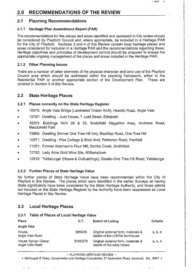
2.2 State Heritage Places
2.2.1 Places currently on the State Heritage Register
• 10570: Angle Vale Bridge [Laminated Timber Arch], Heaslip Road, Angle Vale
• 12787: Dwelling - Judd House, 7 Judd Street, Elizabeth
• 16201: Buildings No's 29 & 33, Smithfield Magazine Area, Andrews Road, Macdonald Park
• 13868: Dwelling (former One Tree Hill Inn), Blacktop Road, One Tree Hill
• 10571: Dwelling- Pise Cottage & Brick Well, Petherton Road, Penfield
• 11051: Former Adamson's Flour Mill, Smiths Creek, Smithfield
• 12782: Lady Alice Gold Mine Site, Williamstown
• 12819: 'Yattalunga' (House & Outbuildings), Gawler-One Tree Hill Road, Yattalunga
2.2.2 Further Places of State Heritage Value
No further places of State Heritage Value have been recommended within the City of Playford in this Review. The places which were identified in the earlier Surveys as having State significance have been considered by the State Heritage Authority, and those places not included on the State Heritage Register by the Authority have been reassessed as Local Heritage Places in this Review.
2.3 Local Heritage Places
2.3.1 Table of Places of Local Heritage Value
Place C.T. Extent of Listing
Angle Vale
House, Angle Vale Road
House 'Sylvan Glade', Angle Vale Road
3885/26 Original external form, materials & details of the c1870s farmhouse
5105/276 Original external form, materials & details of the early house
• PLAYFORD HERITAGE REVIEW •
Criteria
a, b,e
• McDougall & Vines, Conservation and Heritage Consultants, 27 Sydenham Road, Norwood, SA, 5067 •
'-;:,-
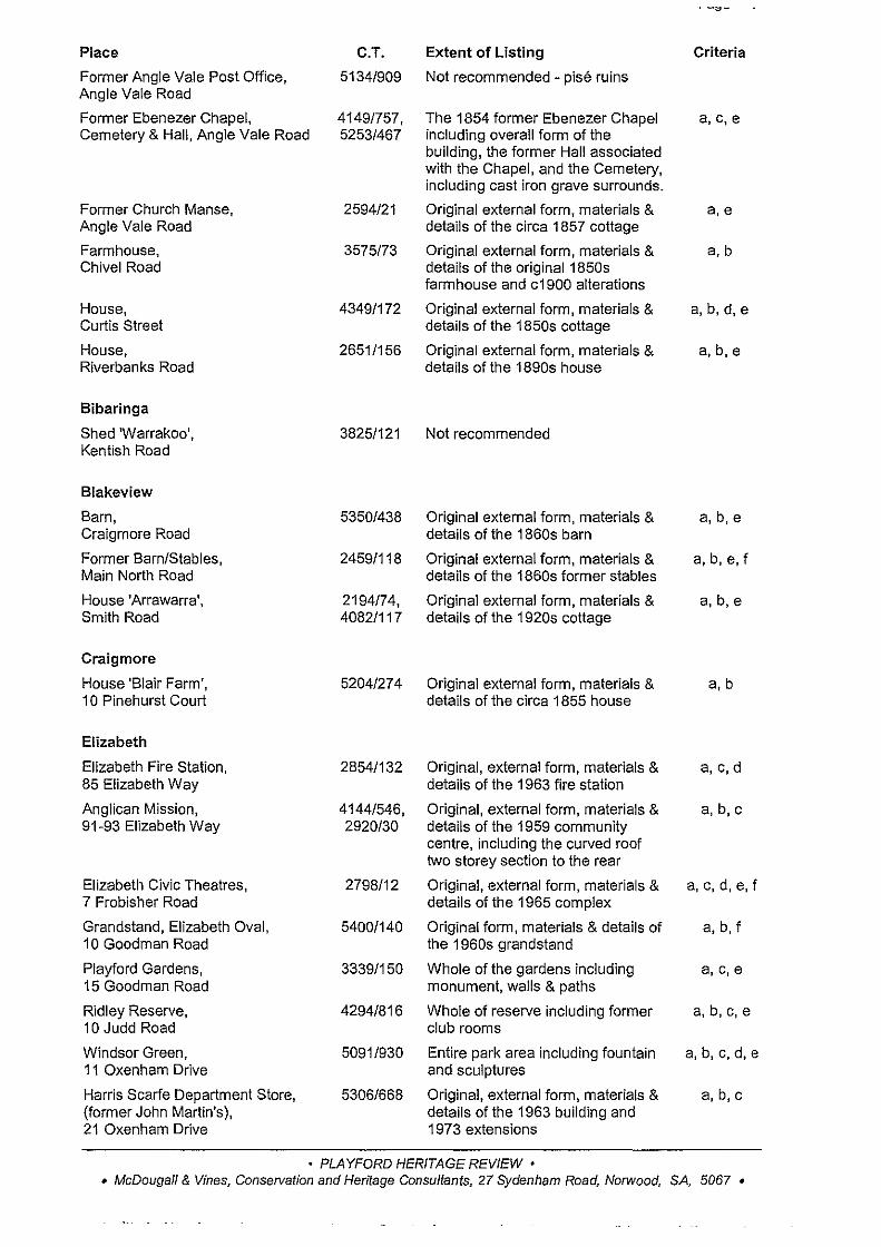
Place C.T. Extent of Listing Criteria
Former Angle Vale Post Office, 5134/909 Not recommended - pise ruins Angle Vale Road
Former Ebenezer Chapel, 4149/757, The 1854 former Ebenezer Chapel a,c,e Cemetery & Hall, Angle Vale Road 5253/467 including overall form of the
building, the former Hall associated with the Chapel, and the Cemetery, including cast iron grave surrounds.
Former Church Manse, 2594/21 Original external form, materials & a,e Angle Vale Road details of the circa 1857 cottage
Farmhouse, 3575/73 Original external form, materials & a,b Chive! Road details of the original 1850s
farmhouse and c1900 alterations
House, 4349/172 Original external form, materials & a,b,d,e Curtis Street details of the 1850s cottage
House, 2651/156 Original external form, materials & a, b,e Riverbanks Road details of the 1890s house
Bibaringa
Shed 'Warrakoo', 3825/121 Not recommended Kentish Road
Blakeview
Barn, 5350/438 Original external form, materials & a, b,e Craigmore Road details of the 1860s barn
Former Barn/Stables, 2459/118 Original external form, materials & a, b, e, f Main North Road details of the 1860s former stables
House 'Arrawarra', 2194/74, Original external form, materials & a, b,e Smith Road 4082/117 details of the 1920s cottage
Craigmore
House 'Blair Farm', 5204/274 Original external form, materials & a,b 1 0 Pinehurst Court details of the circa 1855 house
Elizabeth
Elizabeth Fire Station, 2854/132 Original, external form, materials & a, c,d 85 Elizabeth Way details of the 1963 fire station
Anglican Mission, 4144/546, Original, external form, materials & a, b,c 91-93 Elizabeth Way 2920/30 details of the 1959 community
centre, including the curved roof two storey section to the rear
Elizabeth Civic Theatres, 2798/12 Original, external form, materials & a, c, d, e, f 7 Frobisher Road details of the 1965 complex
Grandstand, Elizabeth Oval, 5400/140 Original form, materials & details of a, b, f 1 0 Goodman Road the 1960s grandstand
Playford Gardens, 3339/150 Whole of the gardens including a, c,e 15 Goodman Road monument, walls & paths
Ridley Reserve, 4294/816 Whole of reserve including former a,b,c,e 10 Judd Road club rooms
Windsor Green, 5091/930 Entire park area including fountain a,b, c,d,e 11 Oxenham Drive and sculptures
Harris Scarfe Department Store, 5306/668 Original, external form, materials & a, b,c (former John Martin's), details of the 1963 building and 21 Oxenham Drive 1973 extensions
• PLAYFORD HERITAGE REVIEW • • McDougall & Vines, ConseTVation and Heritage Consultants, 27 Sydenham Road, Norwood, SA, 5067 •
- -· -
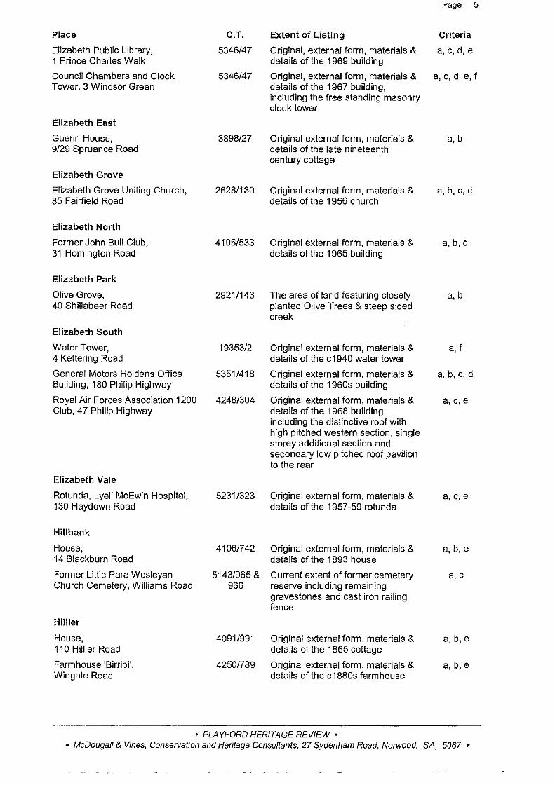
I-' age b
Place C.T. Extent of Listing Criteria
Elizabeth Public Library, 5346/47 Original, external form, materials & a, c,d, e 1 Prince Charles Walk details of the 1969 building
Council Chambers and Clock 5346/47 Original, external form, materials & a, c, d, e, f Tower, 3 Windsor Green details of the 1967 building,
including the free standing masonry clock tower
Elizabeth East
Guerin House, 3898/27 Original external form, materials & a,b 9/29 Spruance Road details of the late nineteenth
century cottage
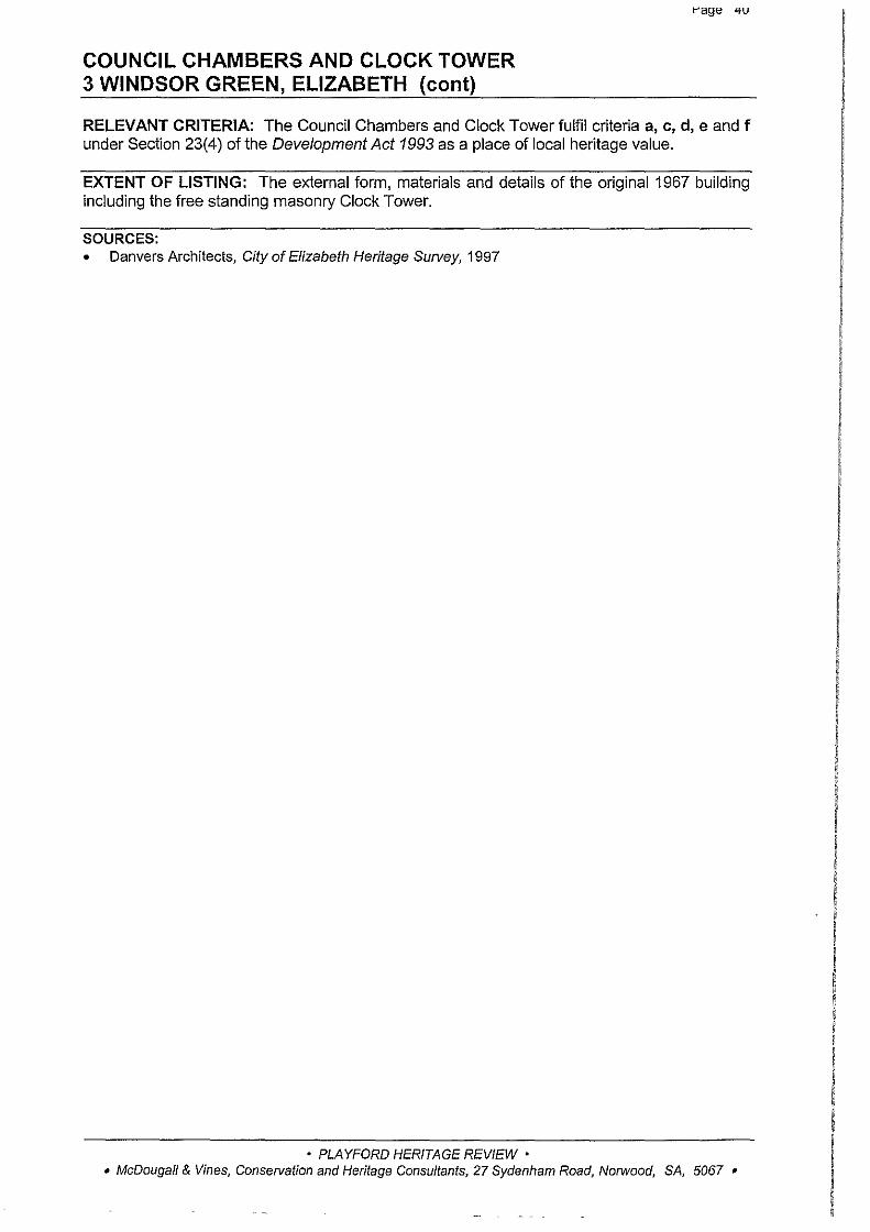
Elizabeth Grove
Elizabeth Grove Uniting Church, 2628/130 Original external form, materials & a,b,c,d 85 Fairfield Road details of the 1956 church
Elizabeth North
Former John Bull Club, 4106/533 Original external form, materials & a, b,c 31 Homington Road details of the 1965 building
Elizabeth Park
Olive Grove, 2921/143 The area of land featuring closely a, b 40 Shillabeer Road planted Olive Trees & steep sided
creek
Elizabeth South
Water Tower, 19353/2 Original external form, materials & a, f 4 Kettering Road details of the c1940 water tower
General Motors Holdens Office 5351/418 Original external form, materials & a, b,c,d Building, 180 Philip Highway details of the 1960s building
Royal Air Forces Association 1200 4248/304 Original external form, materials & a, c,e Club, 47 Philip Highway details of the 1968 building
including the distinctive roof with high pitched western section, single storey additional section and secondary low pitched roof pavilion to the rear
Elizabeth Vale
Rotunda, Lyell McEwin Hospital, 5231/323 Original external form, materials & a,c,e 130 Haydown Road details of the 1957-59 rotunda
Hillbank
House, 4106/742 Original external form, materials & a,b,e 14 Blackburn Road details of the 1893 house
Former Little Para Wesleyan 5143/965 & Current extent of former cemetery a,c Church Cemetery, Williams Road 966 reserve including remaining
gravestones and cast iron railing fence
Hillier
House, 4091/991 Original external form, materials & a, b,e 110 Hillier Road details of the 1865 cottage
Farmhouse 'Birribi', 4250/789 Original external form, materials & a, b,e Wingate Road details of the c1880s farmhouse
• PLAYFORD HERITAGE REVIEW • • McDougall & Vines, Conservation and Heritage Consultants, 27 Sydenham Road, Norwood, SA, 5067 •
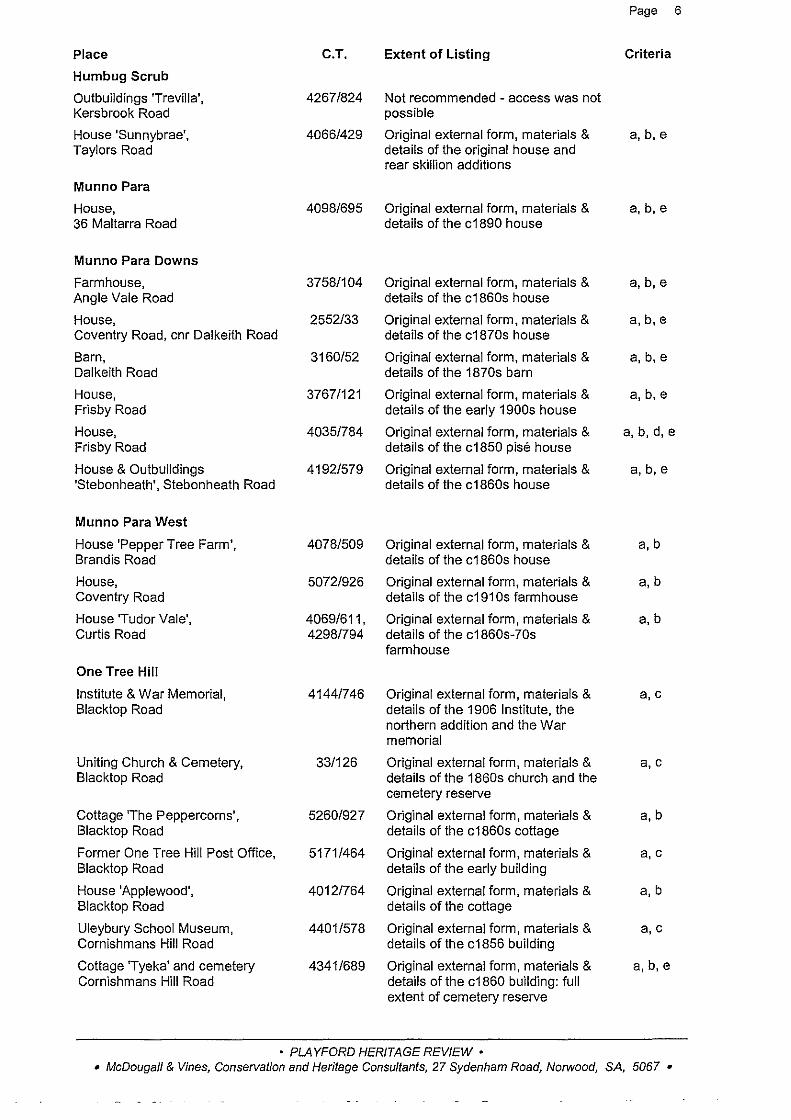
Page 6
Place C.T. Extent of Listing Criteria
Humbug Scrub
Outbuildings 'Trevilla', 4267/824 Not recommended -access was not Kersbrook Road possible
House 'Sunnybrae', 4066/429 Original external form, materials & a,b,e Taylors Road details of the original house and
rear skillion additions
Munno Para
House, 4098/695 Original external form, materials & a,b,e 36 Maltarra Road details of the c1890 house
Munno Para Downs
Farmhouse, 3758/104 Original external form, materials & a,b,e Angle Vale Road details of the c1860s house
House, 2552/33 Original external form, materials & a,b,e Coventry Road, cnr Dalkeith Road details of the c1870s house
Barn, 3160/52 Original external form, materials & a, b,e Dalkeith Road details of the 1870s barn
House, 3767/121 Original external form, materials & a,b,e Frisby Road details of the early 1900s house
House, 4035/784 Original external form, materials & a,b,d,e Frisby Road details of the c1850 pise house
House & Outbuildings 4192/579 Original external form, materials & a,b,e 'Stebonheath', Stebonheath Road details of the c1860s house
Munno Para West
House 'Pepper Tree Farm', 4078/509 Original external form, materials & a,b Brandis Road details of the c1860s house
House, 5072/926 Original external form, materials & a,b Coventry Road details of the c191 Os farmhouse
House 'Tudor Vale', 4069/611' Original external form, materials & a,b Curtis Road 4298/794 details of the c1860s-70s
farmhouse
One Tree Hill
Institute & War Memorial, 4144/746 Original external form, materials & a,c Blacktop Road details of the 1906 Institute, the
northern addition and the War memorial
Uniting Church & Cemetery, 33/126 Original external form, materials & a,c Blacktop Road details of the 1860s church and the
cemetery reserve
Cottage 'The Peppercorns', 5260/927 Original external form, materials & a,b Blacktop Road details of the c1860s cottage
Former One Tree Hill Post Office, 5171/464 Original external form, materials & a, c Blacktop Road details of the early building
House 'Applewood', 4012/764 Original external form, materials & a, b Blacktop Road details of the cottage
Uleybury School Museum, 4401/578 Original external form, materials & a,c Cornishmans Hill Road details of the c1856 building
Cottage 'Tyeka' and cemetery 4341/689 Original external form, materials & a,b,e Cornishmans Hill Road details of the c1860 building: full
extent of cemetery reserve
• PLAYFORD HERITAGE REVIEW • • McDouga/1 & Vines, Conservation and Heritage Consultants, 27 Sydenham Road, Norwood, SA, 5067 •

r-age
Place C.T. Extent of Listing Criteria
Homestead, 4096/39 Original external form, materials & a, b Cornishmans Hill Road details of the c1850s-60s house
House, 4325/77 Original external form, materials & a,b Crosshill Road details of the c1860s house
House 'Crosshill', 2310/135 Original external form, materials & a,b, e Crosshill Road details of the c1860s house including
the later stone section to the rear of the house & associated outbuildings
Former Precolumb School, 2477/17 Original external form, materials & a,c Paines Road details of the c1855 school building
House, 2718/100 Original external form, materials & a,b Paines Road details of the c1880s & 1920s
sections of the house
House 'View Park', 5172/486 Original external form, materials & a, b, d One Tree Hill Road details of the c1870s house
House & Outbuildings 'Yelki', 4353/5 Original external form, materials & a, b,d,e Yorktown Road details of the 1909 house
Penfield
Zoar Cemetery, 2659/138 The cemetery reserve including all a,c Argent Road headstones & cast iron railings
Farmhouse, 5179/891 Demolished Penfield Road, cnr Heaslip Road
Penfield Gardens
Carclew Primitive Methodist 3413/133 Original external form, materials & a,c Church, Carclew Road details of the 1870s church &
adjacent cemetery reserve
House 'Willow Grove', 4075/3 Original external form, materials & a, b, e Taylors Road details of the 1860s farmhouse and
1920s extensions
Farmhouse, 3922/17 Original external form, materials & a, b Winifred Road details of the c1850s-60s
farmhouse
Sampson Flat
House 'Kirklands', 109/539 Original external form, materials & a,b,e One Tre!' Hill Road details of the house
Smithfield
Smithfield Primary School, 3540/68 Original external form, materials & a, c 4 Anderson Walk details of the 1877 stone building
Smithfield Fodder & Pet Supplies, 4002/313 Original external form, materials & a, c, e, f 28 Anderson Walk details of the 1861 building
House, 181/203, Original external form, materials & a,b, e 38 Anderson Walk 2814/132 details of the 1890s house
House, 2146/77 Original external form, materials & a,b, e 44 Anderson Walk details of the late 1890s house
Augusta Square The whole of the square including a, c, d, f several large River Red Gums
Cottage, 4057/834 Original external form, materials & a,c, e 5 Gardiner Terrace details of the c1850s cottage
• PLAYFORD HERITAGE REVIEW • • McDougall & Vines, Conservation and Heritage Consultants, 27 Sydenham Road, Norwood, SA, 5067 •

!-'age tl
Place C.T. Extent of Listing Criteria
Smithfield Railway Cottages, 4289/965- Original external form, materials & a,d 142-145 Graeber Road 4289/969 details of the two pairs of c191 0
attached cottages
Cottage, 2399/176 Original external form, materials & a,b 5 Hope Street details of the 1870s-80s cottage
Cottage, 5181/903 Original external form, materials & a,b,e 24 Jane Street details of the c1860 cottage
Smithfield Hotel, 4221/882 Original external form, materials & a, b, c, e, f 1 Main North Road details of the 1850s hotel
Former Smithfield Methodist 2352/152 Original external form, materials & a,c Church, 6 Samuel St, cnr Mary St details of the 1859 church
Cottage, 4336/105 Original external form, materials & a, b,d 25 Queen Street, cnr Jane Street details of the 1850s-60s cottage
House, 4154/83 Original external form, materials & a,b 4 Rose Street details of the 1920s house
Uleybury
Homestead & Outbuildings 3917/9, 10 External form materials and details a,b 'Craigmore', Craigmore Road of the c1870 stone house and
associated stone outbuilding.
House, Stables/Barn, Shearing 5227/62, Original external form, materials & a,b,e Shed & Sheep Dip, Former 5210/753 details of the c1900 house, c1860s 'Yattalunga' Outbuildings, Medlow stables/barn, shearing shed & dip Road
Quarry, 3929/150, Not recommended - mark site Medlow Road 4128/503
Uley Cemetery & Chapel Site, GD33 The cemetery reserve including the a,b,c,d,e Uley Road (GRO Dep) former 1850s chapel site & stone
boundary wall
Virginia
Homestead 'Virginia Park', 5067/426 The external form, materials and a,b, d,e Brester Road detailing of the 1870 house and the
elements of the subsequent c1920s upgrading.
Farmhouse, 2708/36 Original external form, materials & a,b,e Johns Road details of the 1880s farmhouse
Our Lady of the Assumption 4222/559 Original external form, materials & a,b, c, d Catholid Church, Penfield Road, details of the 1860s church cnr Leach Street
Former Railway Cottages, 5074/560 Original external form, materials & a,e Leach Street, end Brady Street details of the 1920s cottages
Virginia Institute, 2/208 Original external form, materials & a, c, f Old Port Wakefield Road details of the 1908 building
Virginia Post Office, 4230/304 Original external form, materials & a,c Old Port Wakefield Road details of the 1880s post office
Wheatsheaf Hotel, 2615/90 Not recommended Old Port Wakefield Road
Virginia Oval, 4283/525 The recreation reserve including the a, c, f Old Port Wakefield Road oval, memorial gates & pine trees
Farmhouse, 4335/896 Original external form, materials & a,b,e Old Port Wakefield Road details of the early farmhouse &
1920s alterations
• PLAYFORD HERITAGE REVIEW • • McDougall & Vines, Consetvation and Heritage Consultants, 27 Sydenham Road, Norwood, SA, 5067 •

Place
House, Penfield Road
Virginia Methodist Church (former Bible Christian Chapel), Phineas Street
Virginia Uniting Church (former Methodist Church). Phineas Street
House, Ridgeway Road
House 'Almond Grove', Robert Road, cnr Moloney Road
House 'Calvin Grove' Taylors Road
Waterloo Corner
Farmhouse, Taylors Road, cnr Huxtable Rd
Yattalunga
Stone Wall 'Yattalunga', Gawler-One Tree Hill Road
House 'Milton Bank'. Humbug Scrub Road
Humbug Scrub Cottage, off Humbug Scrub Road
Hut, Toolunga Road
Cottage. 29 Toolunga Road
2.3.2 Exclusions
C.T. Extent of Listing
4186/131 The external form, materials and details of the original 1870s stone house including chimneys, and c1900 gable and verandah.
LTG 70 Original external form, materials & details of the 1858 church
L T 70 Original external form, materials & details of the 1937 church
4217/227 Not recommended
2764/96 Original external form, materials & details of the 1860s house
4348/743 Original external form, materials & details of the 1860s-70s house [to be located]
2543/183 Original external form, materials & details of the 1870s farmhouse
4381/605 The c1850s random dry stone wall
4127/79 External form, details and materials of the c1870 stone house, outbuildings and sheds.
1250/127 Original external form, materials & details of the c1919 cottage
4264/23 Not recommended
5260/420 Original external form, materials & details of the c1860s-70s cottage
!-'age ~
Criteria
a,b,e
a,c
a, c
a,b,e
a,b,e
a,b, e
a,b,d,e
a,b,d,e
e
A small number of the places identified as having Local Heritage Value in the 1996 and 1997 Heritage Surveys have been excluded from the list recommended in this Review. These exclusions have been listed as 'not recommended' in the Schedule above. Some places are best recorded in the written history of Playford, or through the marking of the site, as the physical representation and remains are insufficient to be managed through planning provisions.
2.4 Management Recommendations
2.4.1 Introduction
The appropriate management of heritage places within a local government area involves the preparation of a Heritage PAR and also the introduction of sensible management strategies to ensure the care of heritage places in the future. Much of this information was first provided for the City of Playford in a Heritage Policy Review prepared by McDougall & Vines in June 2000. The essential parts of this management strategy are reiterated here.
• PLAYFORD HERITAGE REVIEW • • McDougall & Vines, Conservation and Heritage Consultants, 27 Sydenham Road, Norwood, SA, 5067 •

Page 10
2.4.2 Staff Training and Development
With the introduction of a Heritage PAR, planning and development staff will need training in the appropriate implementation of the policies and principles of development control relating to heritage places within the Development Plan. The recently published Heritage Planning Bulletin (now available through Planning SA and Heritage SA) provides useful background and information for planners and councils.
2.4.3 Heritage Advisory Services
The provision of architectural advice on Development Applications for both residential and commercial buildings with some identified historic character is a positive management tool for heritage conservation within the Playford area. Council should appoint a Heritage Adviser, initially on an 'as needs' basis and publicise the availability and the value of obtaining early advice on Development Applications for heritage buildings.
2.4.4 Financiallncentives
The provision of a Local Heritage Fund is an important strategy in the maintenance of heritage assets within the Playford area. Other Councils such as Port Adelaide Enfield, Holdfast Bay, Willunga and the City of Adelaide have developed Heritage Incentive Schemes based on a local heritage fund. Further information is available from these Councils and is summarised in the Heritage Policy Review Document.
Sponsorship for various forms of conservation work is also an effective financial incentive and Council should consider arranging sponsorship for heritage painting programs and other areas of construction and renovation. Appropriate acknowledgment should be made of any sponsorship provided.
2.4.5 Education and Information
Those properties which Council owns should be used as a way to demonstrate care and good heritage practice as an example for the community. Positive action in the public environment is a useful educational and promotional tool.
Enquiries directed to counter staff at the Council office should be handled positively and staff need to be able to provide preliminary information with regard to Council heritage policies and strategies.
Conservation Guidelines, prepared for particular house styles, fences, agricultural structures, commercial buildings and shopfronts, signs and other issues, are also useful in informing the community as to the level of control implied in the words 'retain and conserve' and other similar phrases which may be used in a Development Plan.
Seminars and workshops on heritage conservation within the Playford Council area should also be considered as these are usually a popular educational process.
Tourists, particularly those with a knowledge of town planning history, or with English migrant associations, can be further encouraged in their interest in the heritage of Playford through appropriate publications and information distributed through tourism outlets.
There are many other ways to inform the public and promote the heritage of Playford and these are further listed in the Heritage Policy Review.
2.4.6 Community Participation
Council should positively encourage community participation in heritage management within the Council area. Many local governments have set up Local Heritage Advisory Committees to provide further advice to Council on heritage matters. The membership of an Advisory Committee should include an appropriate mix of representatives from the community, such as members with expertise in tourism, local history, architecture or planning. Council should also look to continue to expand the local history collections and services of the excellent Local and Family History Service already in place. This is a sensible collection point for local history material from both individual's and Council records.
• PLAYFORD HERITAGE REVIEW • • McDougall & Vines, Conservation and Heritage Consultants, 27 Sydenham Road, Norwood, SA, 5067 •

1-'age 11
3.0 ASSESSMENT OF AREAS
3.1 Elizabeth South
3.1.1 Previously Identified Historic Conservation Zone
There was only one proposed Historic (Conservation) Zone identified in the previous surveys of the area which is now the City of Playford. This is described as the Elizabeth South Historic (Conservation) Zone.
3.1.2 Description of Zone
Elizabeth South was the first module to be planned and built as part of the new Town of Elizabeth. The proposed Historic (Conservation) Zone (refer map) comprises a large portion of the module of Elizabeth South including the earliest development in the suburb, and therefore in Elizabeth. The area was predominantly zoned residential, with two smaller sections within the area set aside for industrial and commercial uses. The layout, land division and built form is typical of the planning and construction carried out by the South Australian Housing Trust in Elizabeth in the late 1950s and early 1960s. Playford Gardens, which lies within the proposed Historic (Conservation) Zone boundaries, was the place where Sir Thomas Playford inaugurated the new Town of Elizabeth on 16 November 1955.
The use of the irregular curvilinear street pattern first developed in Elizabeth South is echoed throughout most of the other suburbs of Elizabeth. There are scattered parks and green areas which are also typical features of Housing Trust planning, and the provision of shops, a school, churches and an industrial zone adjacent to the residential one, was intended to provide employment and facilities for local residents. The location of Elizabeth South was determined in part by the existence of the railway line from Adelaide to the north which theoretically provided early residents with convenient transport to employment outside the area.
The main residential street in Elizabeth South is Goodman Road, and the Philip Highway (running parallel to Goodman Road) provides the community amenities including a hotel, shopping centres, school and petrol station. There is also an industrial area to the south of Hogarth Road which includes the first industrial site in Elizabeth (the former Pinnocks Factory).
Within the residential section of the Zone itself most of the houses are typical examples of Housing Trust design and construction of the late 1950s. The majority of houses are semidetached and built of brick or concrete block, and stylistic elements vary from house to house according to Housing Trust policy at the time. The houses retain a high degree of integrity, but are specifically of a mid 1950s design.
Over time sections of the suburb have been modernised, particularly the shopping centre and the school. Commercial and service buildings and the industrial zone have also changed substantially, particularly along the Philip Highway.
The area of Elizabeth South does retain a large proportion of open space as parks and gardens which was an early priority of the Housing Trust. These park areas and existing mature trees make a significant contribution to the character and amenity of the suburb.
3.1.3 Significance ofthe Zone
Elizabeth has substantial significance as the post War planned modern Garden City north of Adelaide. The 1997 City of Elizabeth heritage survey describes this as 'a unique urban phenomenon emerging from the boom of the mid 1950s'. The subdivision pattern, the reserves and the residential character of the area have significance within the development of Elizabeth itself, as it was the first area of the new planned town to be established.
• PLAYFORD HERITAGE REVIEW • • McDougall & Vines, Conservation and Heritage Consultants, 27 Sydenham Road, Norwood, SA, 5067 •

!-'age 1Z
In the 1997 Survey, a large number of places within the Elizabeth South were assessed as having some significance to the area.
Local heritage significance:
• Playford Gardens, 10 Goodman Road, Elizabeth South (recommended Local Heritage Place)
Contributory to the area:
• Elizabeth South Primary School, Chivell Street, Elizabeth South (expanded and altered)
• Naval Association, 8-12 Chivell Street, Elizabeth South
• Elizabeth Presbyterian Church, 106 Goodman Road, Elizabeth South
• Rose and Crown Hotel, Philip Highway, Elizabeth South (significantly upgraded)
• Elizabeth South Shopping Centre, Philip Highway, Elizabeth South (expanded substantially)
• Webster's Factory (former Pinnock's) Philip Highway, Elizabeth South (now changed significantly from its original character)
Many of these contributory places have necessarily been altered or upgraded over time in order to meet new standards and requirements of new owners or of the community.
The relatively austere character of the residences originally constructed in 1950 means that substantial levels of upgrading are necessary to bring this housing up to current standards. This has already occurred in other areas of Elizabeth. Therefore conservation and protection the existing physical fabric of the area of Elizabeth South is difficult.
However, the town planning elements which include the street pattern, allotment sizes, road widths, reserves, parks and gardens, shopping centres and other public facilities including schools and churches, are significant in terms of the development of Elizabeth itself, and warrant some form of planning and development control.
3.1.4 Recommendations for Elizabeth South
It is not recommended that the area of Elizabeth South be delineated as a Historic (Conservation) Zone, with consequent demolition control. However, a specific policy area should be delineated within an appropriate Residential Zone in order to retain the planning characteristics of the module. The Residential PAR currently being finalised should ensure that the objectives and principles of development control for the area retain the significant town planning elements as noted, particularly the street pattern and reserves. Open spaces, verges and islands should be retained, street planting upgraded, power undergrounded and the general layout of the suburb respected. The historic parameters of the industrial and commercial sections of the area should be carefully considered in any subsequent review of the zoning in the current Development Plan.
Guidelines for upgrading residences within the area should be developed for both the single and double units, and these should be drafted as Principles of Development Control for use in the Residential PAR. These should cover replacement buildings, particularly scale and setback. Standards for upgrading existing houses should cover the style and form of porches, verandahs, windows and hoods, fences and provide some parameters for rear extensions. The issue of matching work on attached double units should also be emphasised in these guidelines.
• PLAYFORD HERITAGE REVIEW • • McDougall & Vines, Conservation and Heritage Consultants, 27 Sydenham Road, Norwood, SA, 5067 •

Elizabeth South Historic (Conservation) Zone proposed in Heritage Survey (1997)
• PLAYFORD HERITAGE REVIEW •
Page 13
• McDougall & Vines, Conservation and Heritage Consultants, 27 Sydenham Road, Norwood, SA, 5067 •
Page 14
3.2 Early Villages in Playford
The settlements of One Tree Hill, Smithfield and Virginia are significant in the history and development of Playford. However, they each now retain insufficient historic context to justify delineation as Historic (Conservation) Zones. Individually significant places within each township have been assessed as Local Heritage Places and included in the recommendations of this report.
3.2.1 One Tree Hill Village Centre
The centre of One Tree Hill is an attractive rural township, already delineated as a Country Township Zone, which contains early, mature street trees including pines, ashes and flowering gums. The height and mass of new development, and set-back which is currently consistently around 6 metres from the pavement line, should continue to be controlled to retain the existing character of the streetscape. Many of these issues are already addressed in the Principles of Development Control in the current Development Plan
3.2.2 Smithfield Early Village Centre
The original subdivision pattern of Smith's Village is still evident, but quite obviously very little development occurred on the allotments which he laid out. Consequently there is little historic fabric to justify delineating this area as an Historic (Conservation) Zone. The retention of Augusta Square in the centre of the subdivision is essential and the listing of the individual early elements within Smithfield will retain what historic fabric now remains. It is important also to retain mature vegetation including the figs and peppercorns in the rear of the primary school grounds, and any other significant trees. The character of new housing in the Smithfield township is addressed in the Residential (Munno Para) Zone of the current Development Plan.
3.2.3 Virginia Village Centre
There is insufficient historic context left to warrant delineation of any core area as an Historic (Conservation) Policy Area. Phineas Street behind the main road retains two early churches which have been included as individual local heritage places and the Institute and early section of the Post Office are also recommended, but the main street (Old Port Wakefield Road) has lost its historic feel. As an alternative, specific guidelines for urban design and upgrading of facilities and amenities within the town centre of Virginia should be prepared as part of any further review of Development Plan provisions.
3.3 Elizabeth Civic Centre
As determined in the individual assessments of places identified in previous surveys, the buildings within the Elizabeth Civic Centre have strong local significance and have social and community value. These heritage values need to be publicly recognised through the listing of these places in the Heritage PAR. At the same time Council acknowledges the need to upgrade the existing community facilities as well as retain the cultural heritage qualities which make Elizabeth such an important regional centre.
Any new development should reflect the 'Elizabeth Aesthetic' (that is, the form and scale of the 1960s buildings), and incorporate as much as possible of the original structures into any extensions or adaptations. Heritage parameters provide a useful discipline for additions to existing buildings, or the design of new buildings, and the proportions and design elements of existing buildings in the Elizabeth Civic Centre are those being used currently by progressive architects. The Theatre complex, Windsor Green, the former John Martin's store, the Library and the Council Chambers and Clock Tower have been recommended as local heritage places in
• PLAYFORD HERITAGE REVIEW· • McDougall & Vines, ConseJVation and Heritage Consultants, 27 Sydenham Road, Norwood, SA, 5067 •
Page 15
this Review. At the time of the preparation of this Review, there is a current approval to change the land use of Windsor Green, and remove its park/reserve character. If this approval is implemented, the sculpture associated with the fountain should be carefully relocated to an appropriate civic and public location.
Heritage issues to consider in the listing and upgrading of the Civic Centre: • The historic nature of the Elizabeth experiment, and particularly its place in the
application of town planning philosophy and theory
• The amount of built fabric which should be retained to represent this in the future
• The style and location of any new development and any change in land use
• The degree to which appreciation of Elizabeth will increase over time in terms of its cultural significance to South Australia
Consequently, any changes within the significant context of the Elizabeth Civic Centre need to be carefully and thoroughly considered from all perspectives. Council has an obligation to balance the cultural heritage value of this significant precinct with the need to upgrade the physical amenities of the Centre.
3.4 Landscape, Topography and Land Use
The City of Playford is composed of two specific topographical zones, the hills to the east, and the plains to the west. The dichotomy between these two elements creates significant zones of cultural landscape due to the traditional agricultural land uses and early settlements across the area. The changes in landscape also include the more recent development of much of the plains area as residential suburbs, and the development of Elizabeth.
With the encroachment of new residential areas into the foothills which were formerly under agricultural use, it will be important to retain some elements of the cultural landscape of Playford. Evidence of early agricultural activity such as fences, historic plantings, sheds, farm outbuildings and other such elements should be retained wherever possible. The village cores of early settlements should also be acknowledged. Stands of original vegetation identified must also be retained in order to represent the natural environment in contrast to the cultural landscape.
The large areas of land owned by the Commonwealth Government which were formerly the munitions stores areas on the plains, if resumed for other uses, should include large areas of agricultural or horticultural activities rather than dense residential development, in order to retain the open space character of this original area of the plains. Much of this area is being replanted with vineyards, and some plains areas still retain their use as wheat and other grain producing areas.
• PLAYFORD HERITAGE REVIEW • • McDougall & Vines, Conservation and Heritage Consultants, 27 Sydenham Road, Norwood, SA, 5067 •

Page 16
4.0 ASSESSMENT OF PLACES
Background and Criteria Individual places have been identified from the previous heritage surveys, fieldwork and some further research. These have then been collated according to town and area alphabetically within the Playford Council area. On the assessment sheets the identification number used in the previous surveys has been noted for ease of correlation. For a summary table of the places assessed, refer to Section 2.3.1 of this Review.
The criteria for determination of heritage value noted on each assessment sheet are those included the Development Act 1993 for places of local heritage value.
The criteria for places of local heritage are as follows:
a) it displays historical, economic or social themes that are of importance to the local area; or
b) it represents customs or ways of life that are characteristic of the local area; or
c) it has played and important part in the lives of local residents; or
d) it displays aesthetic merit design characteristics or construction techniques of significance to the local area; or
e) it is associated with a notable personality or event; or
f) it is a notable landmark in the area.
Places identified as having local heritage value fulfil one or more of these criteria.
• PLAYFORD HERITAGE REVIEW • • McDougall & Vines, Conservation and Heritage Consultants, 27 Sydenham Road, Norwood, SA, 5067 •

HOUSE ANGLE VALE ROAD, ANGLE VALE
Page 17
Heritage Survey No: ANG:001
CT: 3885126
DESCRIPTION: A random rubble stone house with brick quoins and surrounds, hipped corrugated iron roof with gablet and rendered chimneys, and raked verandah on simple timber posts. The house has been extended to the rear. The property was purchased by Luder Krudop in 1866. He owned the property until 1905 when it was purchased by Alfred Burdon, and from the current appearance of the house it is most likely that it dates from this time, although it may incorporate an earlier dwelling built by Krudop.
STATEMENT OF HERITAGE VALUE: An early farmhouse in the Angle Vale area, associated with notable settlers in the district, Luder Krudop and Alfred Burdon.
RELEVANT CRITERIA: The house fulfils criteria a, b and e under Section 23(4) of the Development Act 1993 as a place of local heritage value.
EXTENT OF LISTING: The external form, materials and details of the original circa 1910s farm house are included in the listing including roof with small gab let and rendered chimneys.
SOURCES: • Sarah Laurence and Taylor Weidenhofer, Heritage Swvey of the City of Munno Para, 1996 • Rate Assessment Books, District Council of Munno Para West 1854-1875, 1884-1916 • L TO title records CT80/23
• PLAYFORD HERITAGE REVIEW • • McDougall & Vines, Conservation and Heritage Consultants, 27 Sydenham Road, Norwood, SA, 5067 •

HOUSE 'SYLVAN GLADE' ANGLE VALE ROAD, ANGLE VALE
Page 18
Heritage Survey No: ANG:002
CT: 5105/276
DESCRIPTION: A random coursed bluestone house with hipped corrugated iron roof and rendered chimneys, double hung sash windows, and raked return verandah on timber posts with simple timber brackets. The house has been extensively restored and substantial sympathetic additions have been constructed on the western side of the original building. The land on which this house stands was granted to Samuel White in 1852. It was subsequently purchased by Benjamin Heaslip and in 1853 and 1854 he took out a mortgages for £100, possibly to build the house. Rate assessments from the mid 1850s indicate a house on the property. In 1892 a further mortgage was taken out, possibly for extensions to the residence, as its current appearance is of a later date than the 1850s. The property was sold to Alfred Burford in 1896. Burford and his family owned the property until 1956.
STATEMENT OF HERITAGE VALUE: A large and substantial farmhouse in the Angle Vale area associated with early settler, Benjamin Heaslip and the Burford family.
RELEVANT CRITERIA: 'Sylvan Glade' fulfils criteria a, b and e under Section 23(4) of the Development Act 1993 as a place of local heritage value.
EXTENT OF LISTING: The external form, materials and details of the early farmhouse including concave verandah with timber posts, and later extension to the west.
SOURCES: • Sarah Laurence and Taylor Weidenhofer, Heritage Survey of the City of Munno Para, 1996 • Rate Assessment Books, District Council of Munno Para West 1854-1875 • L TO title records CT 995/9
• PLAYFORD HERITAGE REVIEW • • McDougall & Vines, Conservation and Heritage Consultants, 27 Sydenham Road, Norwood, SA, 5067 •

FORMER ANGLE VALE POST OFFICE ANGLE VALE ROAD, ANGLE VALE
Page 19
Heritage Survey No: ANG:003
CT: 5134/909
DESCRIPTION: The Angle Vale Post Office was constructed in the mid-1860s and functioned until the 1980s. As it was built of pise, the building has deteriorated considerably since it was closed, and is now in a derelict state.
RECOMMENDATIONS: This place is not recommended for listing due to its ruinous condition.
SOURCES: • Sarah Laurence and Taylor Weidenhofer, Heritage Survey of the City of Munno Para, 1996
• PLA YFORO HERITAGE REVIEW • • McDougall & Vines, Conservation and Heritage Consultants, 27 Sydenham Road, Norwood, SA, 5067 •

Page 20
FMR EBENEZER CHAPEL, CEMETERY & HALL Heritage Survey No: ANG:004
ANGLE VALE ROAD, ANGLE VALE cr: 4149/757, 52531467
The former Chapel is of rendered construction with gabled corrugated iron roof with parapet, a small gable porch to front elevation and hopper and fixed pane windows (some with lead lighting). The hall to the rear of the church is of random rubble stone with brick quoins and rendered section to the front, and with corrugated iron roof. The cemetery includes older and more recent headstones, many surrounded by iron fences. The chapel and hall are currently being renovated and repainted, and the roof line has been extended to create eaves overhangs on both the main chapel and the front porch.
The chapel was constructed in 1854 after the Reverend Samuel Keen selected the site for the Bible Christian Chapel, and the hall and cemetery were associated with the initial congregation.
STATEMENT OF HERITAGE VALUE: This early church was the first built (in 1854) to provide a venue for Bible Christian services on the plains north of Adelaide and has played an important role in the religious development of the area.
RELEVANT CRITERIA: The former Ebenezer Chapel, Cemetery and Hall fulfil criteria a, c and e under Section 23(4) of the Development Act 1993 as a place of local heritage value.
EXTENT OF LISTING: The 1854 former Ebenezer Chapel including overall form of the building, the former Hall associated with the Chapel, and the Cemetery, including cast iron grave surrounds.
SOURCES: • Sarah Laurence and Taylor Weidenhofer, Heritage Survey of the City of Munno Para, 1996
• PLAYFORD HERITAGE REVIEW • • McDougall & Vines, Conservation and Heritage Consultants, 27 Sydenham Road, Norwood, SA, 5067 •
Page 21
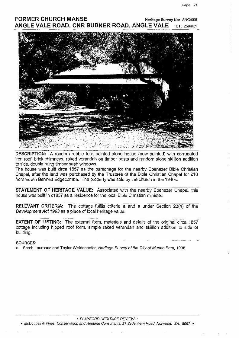
FORMER CHURCH MANSE Heritage Survey No: ANG:005
ANGLE VALE ROAD, CNR BUBNER ROAD, ANGLE VALE cT: 2594121
'- .. ' - -,' ::> - '
DESCRIPTION: A random rubble tuck pointed stone house (now painted) with corrugated iron roof, brick chimneys, raked verandah on timber posts and random stone skillion addition to side, double hung timber sash windows. The house was built circa 1857 as the parsonage for the nearby Ebenezer Bible Christian Chapel, after the land was purchased by the Trustees of the Bible Christian Chapel for £10 from Edwin Bennett Edgecombe. The property was sold by the church in the 1940s.
STATEMENT OF HERITAGE VALUE: Associated with the nearby Ebenezer Chapel, this house was built in c1857 as a residence for the local Bible Christian minister.
RELEVANT CRITERIA: The cottage fulfils criteria a and e under Section 23(4) of the Development Act 1993 as a place of local heritage value.
EXTENT OF LISTING: The external form, materials and details of the original circa 1857 cottage including hipped roof form, simple raked verandah and skillion addition to side of building.
SOURCES: • Sarah Laurence and Taylor Weidenhofer, Heritage Survey of the City of Munno Para, 1996
• PLAYFORD HERITAGE REVIEW • • McDougall & Vines, Conservation and Heritage Consultants, 27 Sydenham Road, Norwood, SA, 5067 •
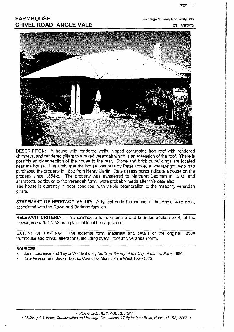
FARMHOUSE CHIVEL ROAD, ANGLE VALE
Page 22
Heritage Survey No: ANG:006
CT: 3575/73
DESCRIPTION: A house with rendered walls, hipped corrugated iron roof with rendered chimneys, and rendered pillars to a raked verandah which is an extension of the roof. There is possibly an older section of the house to the rear. Stone and brick outbuildings are located near the house. It is likely that the house was built by Peter Rowe, a wheelwright, who had purchased the property in 1853 from Henry Martin. Rate assessments indicate a house on the property since 1854-5. The property was transferred to Margaret Badman in 1903, and alterations, particular to the verandah form, were probably made after this date also. The house is currently in poor condition, with visible deterioration to the masonry verandah pillars.
STATEMENT OF HERITAGE VALUE: A typical early farmhouse in the Angle Vale area, associated with the Rowe and Badman families.
RELEVANT CRITERIA: This farmhouse fulfils criteria a and b under Section 23(4) of the Development Act 1993 as a place of local heritage value.
EXTENT OF LISTING: The external forrn, materials and details of the original 1850s farmhouse and c1903 alterations, including overall roof and verandah forrn.
SOURCES: • Sarah Laurence and Taylor Weidenhofer, Heritage Survey of the City of Munno Para, 1996 • Rate Assessment Books, District Council of Munno Para West 1854-1875
• PLAYFORD HERITAGE REVIEW • • McDougall & Vines, Conservation and Heritage Consultants, 27 Sydenham Road, Norwood, SA, 5067 •
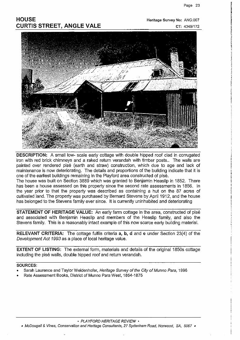
HOUSE CURTIS STREET, ANGLE VALE
Page 23
Heritage Survey No: ANG:007
CT: 4349/172
DESCRIPTION: A small low- scale early cottage with double hipped roof clad in corrugated iron with red brick chimneys and a raked return verandah with timber posts.. The walls are painted over rendered pise (earth and straw) construction, which due to age and Jack of maintenance is now deteriorating. The details and proportions of the building indicate that it is one of the earliest buildings remaining in the Playford area constructed of pise. The house was built on Section 3889 which was granted to Benjamin Heaslip in 1852. There has been a house assessed on this property since the second rate assessments in 1856. In the year prior to that the property was described as containing a hut on the 87 acres of cultivated land. The property was purchased by Bernard Stevens by April 1912, and the house has belonged to the Stevens family ever since. It is currently uninhabited and deteriorating
STATEMENT OF HERITAGE VALUE: An early farm cottage in the area, constructed of pise and associated with Benjamin Heaslip and members of the Heaslip family, and also the Stevens family. This is a reasonably intact example of this now scarce early building material.
RELEVANT CRITERIA: The cottage fulfils criteria a, b, d and e under Section 23(4) of the Development Act 1993 as a place of local heritage value.
EXTENT OF LISTING: The external form, materials and details of the original1850s cottage including the pise walls, double hipped roof and return verandah.
SOURCES: • Sarah Laurence and Taylor Weidenhofer, Heritage Survey of the City of Munno Para, 1996 • Rate Assessment Books, District of Munno Para West, 1854-1875
• PLAYFORD HERITAGE REVIEW • • McDougall & Vines, Conservation and Heritage Consultants, 27 Sydenham Road, Norwood, SA, 5067 •
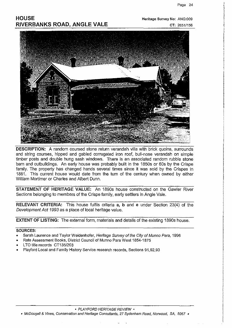
HOUSE RIVERBANKS ROAD, ANGLE VALE
Page 24
Heritage Survey No: ANG:009
CT: 2651/156
DESCRIPTION: A random coursed stone return verandah villa with brick quoins, surrounds and string courses, hipped and gabled corrugated iron roof, bull-nose verandah on simple timber posts and double hung sash windows. There is an associated random rubble stone barn and outbuildings. An early house was probably built in the 1850s or 60s by the Crispe family. The property has changed hands several times since it was sold by the Crispes in 1881. This current house would date from the turn of the century when owned by either William Mortimer or Charles and Albert Dunn.
STATEMENT OF HERITAGE VALUE: An 1890s house constructed on the Gawler River Sections belonging to rnernbers of the Crispe family, early settlers in Angle Vale.
RELEVANT CRITERIA: This house fulfils criteria a, b and e under Section 23(4) of the Development Act 1993 as a place of local heritage value.
EXTENT OF LISTING: The external form, materials and details of the existing 1890s house.
SOURCES: • Sarah Laurence and Taylor Weidenhofer, Heritage Survey ofthe City of Munno Para, 1996 • Rate Assessment Books, District Council of Munno Para West 1854-1875 • L TO title records CT135/203 • Playford Local and Family History Service research records, Sections 91,92,93
• PLAYFORD HERITAGE REVIEW • • McDougall & Vines, Consetvation and Heritage Consultants, 27 Sydenham Road, Norwood, SA, 5067 •
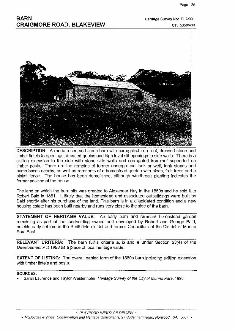
BARN CRAIGMORE ROAD, BLAKEVIEW
Page 25
Heritage Survey No: BLA:001
CT: 5350/438
DESCRIPTION: A random coursed stone barn with corrugated iron roof, dressed stone and timber lintels to openings, dressed quoins and high level slit openings to side walls. There is a skillion extension to the side with stone side walls and corrugated iron roof supported on timber posts. There are the remains of former underground tank or well, tank stands and pump bases nearby, as well as remnants of a homestead garden with aloes, fruit trees and a picket fence. The house has been demolished, although windbreak planting indicates the former position of the house.
The land on which the barn sits was granted to Alexander Hay in the 1850s and he sold it to Robert Bald in 1861. It likely that the homestead and associated outbuildings were built by Bald shortly after his purchase of the land. This barn is in a dilapidated condition and a new housing estate has been built nearby and runs very close to the side of the barn.
STATEMENT OF HERITAGE VALUE: An early barn and remnant homestead garden remaining as part of the landholding owned and developed by Robert and George Bald, notable early settlers in the Smithfield district and former Councillors of the District of Munno Para East.
RELEVANT CRITERIA: The barn fulfils criteria a, b and e under Section 23(4) of the Development Act 1993 as a place of local heritage value.
EXTENT OF LISTING: The overall gabled form of the 1860s barn including skillion extension with timber lintels and posts.
SOURCES: • Sarah Laurence and Taylor Weidenhofer, Heritage Survey of the City of Munno Para, 1996
• PLAYFORD HERITAGE REVIEW • • McDougall & Vines, Conservation and Heritage Consultants, 27 Sydenham Road, Norwood, SA, 5067 •

FORMER BARN/STABLES MAIN NORTH ROAD, BLAKEVIEW
Page 26
Heritage Survey No: BLA:002
CT: 2459/118
DESCRIPTION: A random stone building with brick quoins, surrounds and string courses. It has a gabled roof clad with corrugated iron with ridge vent, there are vents to the gable ends. Some of the ground level openings have been filled in and damage by vandals is evident, the barn is now in a deteriorated condition. The barn is the only structure remaining on the site of John Smith's homestead. Smith was one of the first settlers in the district, who founded the township of Smithfield and helped build the Smithfield Presbyterian Church. He also built the Smithfield Hotel in 1856-57. He was the district's largest land holder and the scale of his property is reflected in the size of the barn which remains. The barn was built circa 1860. There are also several large trees remaining from the family's first settlement of the area in 1847 including a large Carob tree.
STATEMENT OF HERITAGE VALUE: This building is the last relic of John Smith's farm. John Smith was the founder of Smithfield, after whom the district was named, and was one of the first settlers in the area. The scale of this building is indicative of the size of Smith's property and represents the extent of agricultural development in the area.
RELEVANT CRITERIA: The former barn/stables fulfils criteria a, b, e and f under Section 23(4) of the Development Act 1993 as a place of local heritage value.
EXTENT OF LISTING: The simple overall gabled form and details of the 1860s former barn/stables, including brick quoins and string course, and surrounds to openings.
SOURCES: • Sarah Laurence and Taylor Weidenhofer, Heritage Survey of the City of Munno Para, 1996 • Playford Local History Centre, photographic collection, photo no 6065
• PLAYFORD HERITAGE REVIEW • • McDougall & Vines, Conservation and Heritage Consultants, 27 Sydenham Road, Norwood, SA, 5067 •
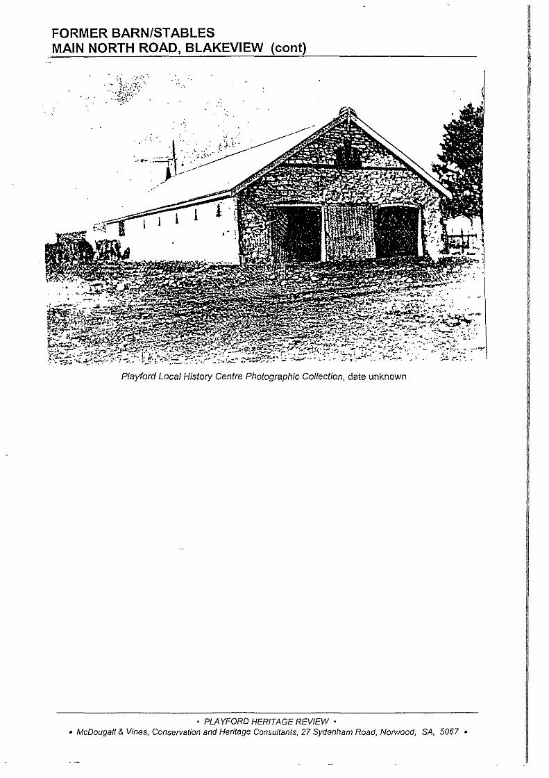
FORMER BARN/STABLES MAIN NORTH ROAD, BLAKEVIEW (cant)
·.·.
I l
Playford Local History Centre Photographic Collection, date unknown
• PLAYFORD HERITAGE REVIEW • • McDougall & Vines, Conservation and Heritage Consultants, 27 Sydenham Road, Norwood, SA, 5067 •
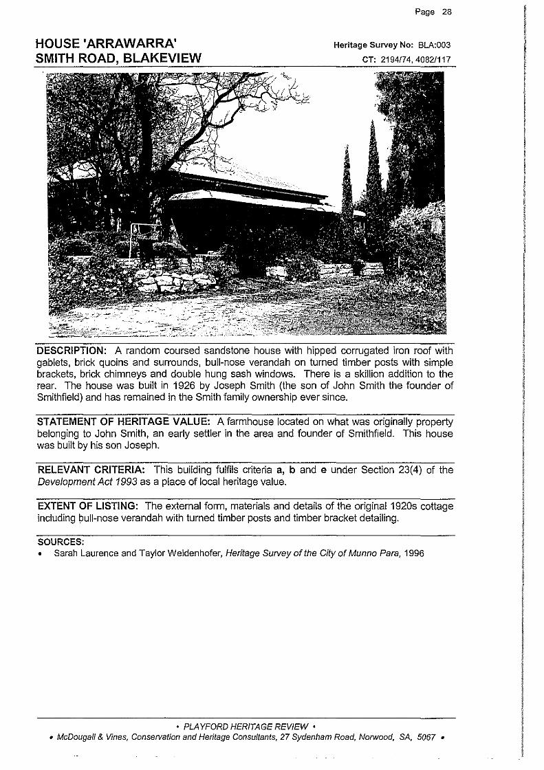
HOUSE 'ARRAWARRA' SMITH ROAD, BLAKEVIEW
Page 28
Heritage Survey No: BLA:003
CT: 2194/7 4, 4082/117
DESCRIPTION: A random coursed sandstone house with hipped corrugated iron roof with gablets, brick quoins and surrounds, bull-nose verandah on turned timber posts with simple brackets, brick chimneys and double hung sash windows. There is a skillion addition to the rear. The house was built in 1926 by Joseph Smith (the son of John Smith the founder of Smithfield) and has remained in the Smith family ownership ever since.
STATEMENT OF HERITAGE VALUE: A farmhouse located on what was originally property belonging to John Smith, an early settler in the area and founder of Smithfield. This house was built by his son Joseph.
RELEVANT CRITERIA: This building fulfils criteria a, b and e under Section 23(4) of the Development Act 1993 as a place of local heritage value.
EXTENT OF LISTING: The external form, materials and details of the original1920s cottage including bull-nose verandah with turned timber posts and timber bracket detailing.
SOURCES: • Sarah Laurence and Taylor Weidenhofer, Heritage Survey of the City of Munno Para, 1996
• PLAYFORD HERITAGE REVIEW • • McDougall & Vines, Conservation and Heritage Consultants, 27 Sydenham Road, Norwood, SA, 5067 •

HOUSE 'BLAIR FARM' 10 PINEHURST COURT, CRAIGMORE
Page 29
Heritage Survey No: CRA:001
CT: 5204/274
DESCRIPTION: A random coursed sandstone house with rendered quoins and surrounds, hipped roof clad with slate, rendered chimneys, concave return verandah on simple timber posts with timber brackets, and double hung sash windows with timber shutters. The verandah is clad with corrugated iron. The house was built circa 1855 and was originally part of a large landholding, but it is now surrounded by modern dwellings which were built after the subdivision of the property in 1961.
STATEMENT OF HERITAGE VALUE: An early farmhouse in the foothills of Craigmore, representative of the early rural development of the area.
RELEVANT CRITERIA: This farmhouse fulfils criteria a and b under Section 23(4) of the Development Act 1993 as a place of local heritage value.
EXTENT OF LISTING: The external form, materials and details of the original circa 1855 house including concave verandah, slate roof and timber verandah posts with brackets.
SOURCES: • Sarah Laurence and Taylor Weidenhofer, Heritage Survey of the City of Munno Para, 1996
• PLAYFORD HERITAGE REVIEW • • McDougall & Vines, Conservation and Heritage Consultants, 27 Sydenham Road, Norwood, SA, 5067 •
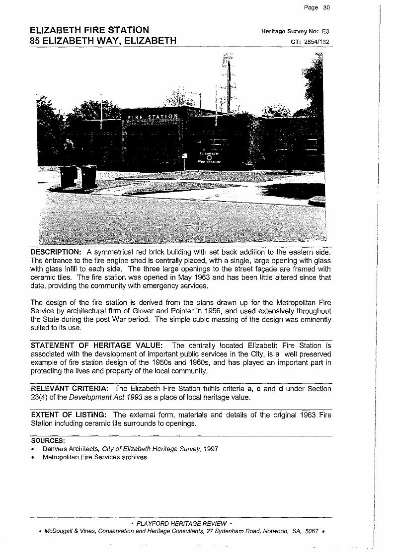
ELIZABETH FIRE STATION 85 ELIZABETH WAY, ELIZABETH
Page 30
Heritage Survey No: E3
CT: 2854/132
A symmetrical red brick building with set back addition to the eastern side. The entrance to the fire engine shed is centrally placed, with a single, large opening with glass with glass infill to each side. The three large openings to the street fac;:ade are framed with ceramic tiles. The fire station was opened in May 1963 and has been little altered since that date, providing the community with emergency services.
The design of the fire station is derived from the plans drawn up for the Metropolitan Fire Service by architectural firm of Glover and Pointer in 1956, and used extensively throughout the State during the post War period. The simple cubic massing of the design was eminently suited to its use.
STATEMENT OF HERITAGE VALUE: The centrally located Elizabeth Fire Station is associated with the development of important public services in the City, is a well preserved example of fire station design of the 1950s and 1960s, and has played an important part in protecting the lives and property of the local community.
RELEVANT CRITERIA: The Elizabeth Fire Station fulfils criteria a, c and d under Section 23(4) of the Development Act 1993 as a place of local heritage value.
EXTENT OF LISTING: The external form, materials and details of the original 1963 Fire Station including ceramic tile surrounds to openings.
SOURCES: • Danvers Architects, City of Elizabeth Heritage Survey, 1997 • Metropolitan Fire Services archives.
• PLAYFORD HERITAGE REVIEW • • McDougall & Vines, Conservation and Heritage Consultants, 27 Sydenham Road, Norwood, SA, 5067 •
ANGLICAN MISSION 91-93 ELIZABETH WAY, ELIZABETH
Page 31
Heritage Survey No: E4
CT: 4144/546, 2920/30
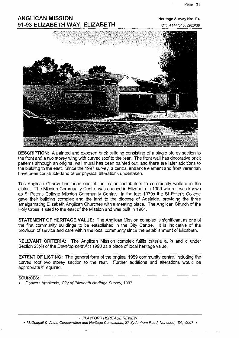
DESCRIPTION: A painted and exposed brick building consisting of a single storey section to the front and a two storey wing with curved roof to the rear. The front wall has decorative brick patterns although an original wall rnural has been painted out, and there are later additions to the building to the east. Since the 1997 survey, a central entrance element and front verandah have been constructedand other physical alterations undertaken.
The Anglican Church has been one of the rnajor contributors to cornrnunity welfare in the district. The Mission Cornrnunity Centre was opened in Elizabeth in 1959 when it was known as St Peter's College Mission Cornrnunity Centre. In the late 1970s the St Peter's College gave their building complex and the land to the diocese of Adelaide, providing the three arnalgarnating Elizabeth Anglican Churches with a meeting place. The Anglican Church of the Holy Cross is sited to the east of the Mission and was built in 1981.
STATEMENT OF HERITAGE VALUE: The Anglican Mission complex is significant as one of the first cornrnunity buildings to be established in the City Centre. It is indicative of the provision of service and care within the local cornrnunity since the establishment of Elizabeth.
RELEVANT CRITERIA: The Anglican Mission complex fulfils criteria a, b and c under Section 23(4) of the Development Act 1993 as a place of local heritage value.
EXTENT OF LISTING: The general forrn of the original 1959 cornrnunity centre, including the curved roof two storey section to the rear. Further additions and alterations would be appropriate if required.
SOURCES: • Danvers Architects, City of Elizabeth Heritage Survey, 1997
• PLAYFORD HERITAGE REVIEW • • McDougall & Vines, Conservation and Heritage Consultants, 27 Sydenham Road, Norwood, SA, 5067 •
ELIZABETH CIVIC THEATRES 7 FROBISHER ROAD, ELIZABETH
Page 32
Heritage Survey No: E5
CT: 2798/12
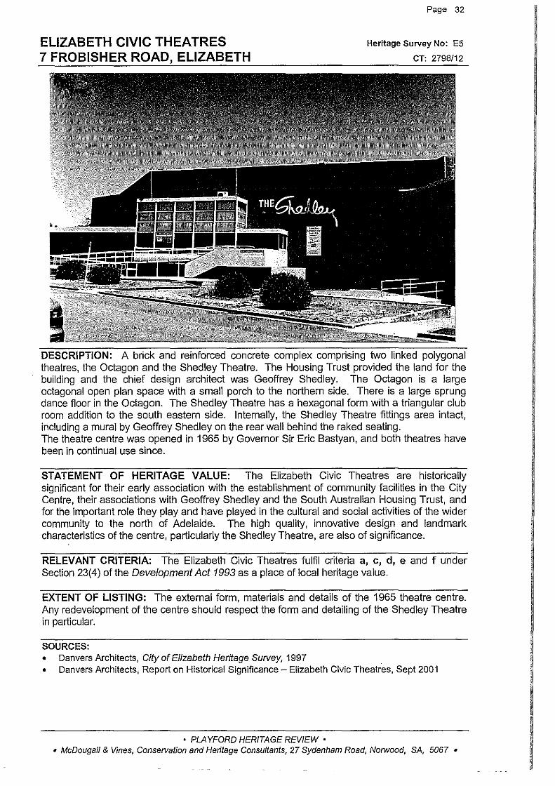
DESCRIPTION: A brick and reinforced concrete complex comprising two linked polygonal theatres, the Octagon and the Shed ley Theatre. The Housing Trust provided the land for the building and the chief design architect was Geoffrey Shedley. The Octagon is a large octagonal open plan space with a small porch to the northern side. There is a large sprung dance floor in the Octagon. The Shedley Theatre has a hexagonal form with a triangular club room addition to the south eastern side. Internally, the Shedley Theatre fittings area intact, including a mural by Geoffrey Shedley on the rear wall behind the raked seating. The theatre centre was opened in 1965 by Governor Sir Eric Bastyan, and both theatres have been in continual use since.
STATEMENT OF HERITAGE VALUE: The Elizabeth Civic Theatres are historically significant for their early association with the establishment of community facilities in the City Centre, their associations with Geoffrey Shedley and the South Australian Housing Trust, and for the important role they play and have played in the cultural and social activities of the wider community to the north of Adelaide. The high quality, innovative design and landmark characteristics of the centre, particularly the Shedley Theatre, are also of significance.
RELEVANT CRITERIA: The Elizabeth Civic Theatres fulfil criteria a, c, d, e and f under Section 23(4) of the Development Act 1993 as a place of local heritage value.
EXTENT OF LISTING: The external form, materials and details of the 1965 theatre centre. Any redevelopment of the centre should respect the form and detailing of the Shedley Theatre in particular.
SOURCES: • Danvers Architects, City of Elizabeth Heritage Survey, 1997 • Danvers Architects, Report on Historical Significance- Elizabeth Civic Theatres, Sept 2001
• PLAYFORD HERITAGE REVIEW • • McDougall & Vines, Conservation and Heritage Consultants, 27 Sydenham Road, Norwood, SA, 5067 •

GRANDSTAND, ELIZABETH OVAL 10 GOODMAN ROAD, ELIZABETH
Page 33
Heritage Survey No: E8
CT: 5400/140
DESCRIPTION: A steel and reinforced concrete grandstand constructed circa 1960. The grandstand has stepped seating, a cantilevered roof and a single story brick projection to the rear which contains changing rooms and bathrooms.
STATEMENT OF HERITAGE VALUE: This is the major structure at the Elizabeth Oval and is significant for its association with the Central Districts Football Club and its representation of the significance of sporting activities in the Elizabeth area.
RELEVANT CRITERIA: This Grandstand fulfils criteria a, band f under Section 23(4) of the Development Act 1993 as a place of local heritage value.
EXTENT OF LISTING: The overall form of the 1960s grandstand including the concrete base and cantilevered roof structure.
SOURCES: • Danvers Architects, City of Elizabeth Heritage Survey, 1997
• PLAYFORD HERITAGE REVIEW • • McDougall & Vines, Conservation and Heritage Consultants, 27 Sydenham Road, Norwood, SA, 5067 •

PLAYFORD GARDENS 15 GOODMAN ROAD, ELIZABETH
Page 34
Heritage Survey No: E9
CT: 3339/150
DESCRIPTION: A small grassed area with some trees, one of a number of reserves in the initial planned module for Elizabeth. On top of a low rise there is a central concrete monument, constructed in 1975, which commemorates the foundation of the City of Elizabeth in November 1955. The monument is surrounded by low walls, with three walled paths giving access to the monument.
STATEMENT OF HERITAGE VALUE: The monument and gardens mark the site of the official opening of Elizabeth and are significant for their associations with Sir Thomas Playford and the inauguration ceremony symbolising the establishment of the new town.
RELEVANT CRITERIA: Playford Gardens fulfil criteria a, c and e under Section 23(4) of the Development Act 1993 as a place of local heritage value.
EXTENT OF LISTING: The whole of the gardens including concrete monument and surrounding low walls and walled paths.
SOURCES: • Danvers Architects, City of Elizabeth Heritage Survey, 1997
• PLAYFORD HERITAGE REVIEW • • McDougall & Vines, Conservation and Heritage Consultants, 27 Sydenham Road, Norwood, SA, 5067 •
RIDLEY RESERVE 10 JUDD ROAD, ELIZABETH
Page 35
Heritage Survey No: E11
CT: 4294/816
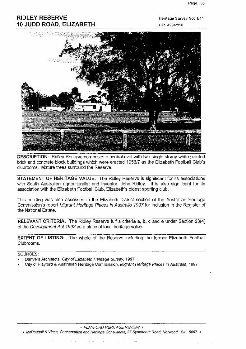
DESCRIPTION: Ridley Reserve comprises a central oval with two single storey white painted brick and concrete block buildings which were erected 1956/7 as the Elizabeth Football Club's clubrooms. Mature trees surround the Reserve.
STATEMENT OF HERITAGE VALUE: The Ridley Reserve is significant for its associations with South Australian agriculturalist and inventor, John Ridley. It is also significant for its association with the Elizabeth Football Club, Elizabeth's oldest sporting club.
This building was also assessed in the Elizabeth District section of the Australian Heritage Commission's report Migrant Heritage Places in Australia 1997 for inclusion in the Register of the National Estate.
RELEVANT CRITERIA: The Ridley Reserve fulfils criteria a, b, c and e under Section 23(4) of the Development Act 1993 as a place of local heritage value.
EXTENT OF LISTING: The whole of the Reserve including the former Elizabeth Football Clubrooms.
SOURCES: • Danvers Architects, City of Elizabeth Heritage Survey, 1997 • City of Playford & Australian Heritage Commission, Migrant Heritage Places in Australia, 1997
• PLAYFORD HERITAGE REVIEW • • McDougall & Vines, Consetvation and Heritage Consultants, 27 Sydenham Road, Norwood, SA, 5067 •
WINDSOR GREEN 11 OXENHAM DRIVE, ELIZABETH
Page 36
Heritage Survey No: E12
CT: 5091/930
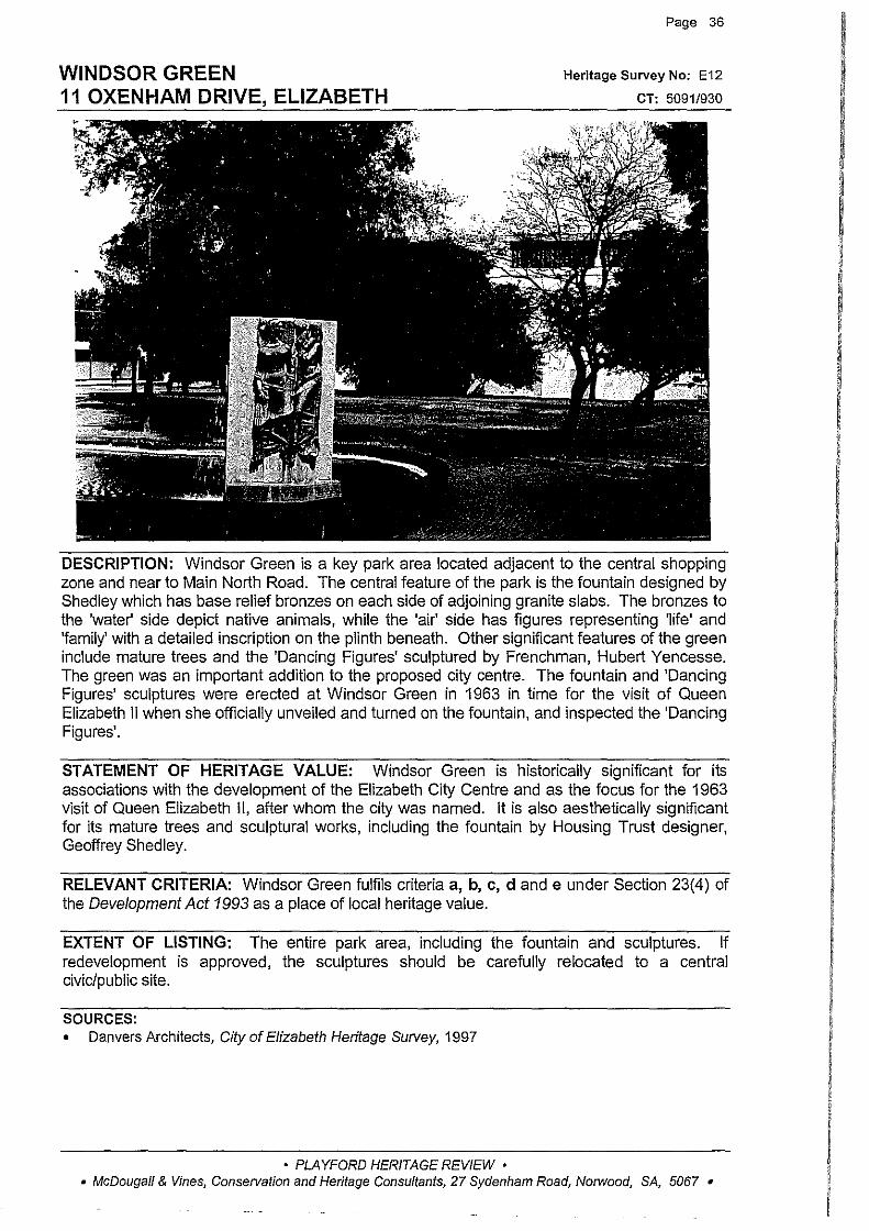
DESCRIPTION: Windsor Green is a key park area located adjacent to the central shopping zone and near to Main North Road. The central feature of the park is the fountain designed by Shedley which has base relief bronzes on each side of adjoining granite slabs. The bronzes to the 'water' side depict native animals, while the 'air' side has figures representing 'life' and 'family' with a detailed inscription on the plinth beneath. Other significant features of the green include mature trees and the 'Dancing Figures' sculptured by Frenchman, Hubert Yencesse. The green was an important addition to the proposed city centre. The fountain and 'Dancing Figures' sculptures were erected at Windsor Green in 1963 in time for the visit of Queen Elizabeth II when she officially unveiled and turned on the fountain, and inspected the 'Dancing Figures'.
STATEMENT OF HERITAGE VALUE: Windsor Green is historically significant for its associations with the development of the Elizabeth City Centre and as the focus for the 1963 visit of Queen Elizabeth II, after whom the city was named. It is also aesthetically significant for its mature trees and sculptural works, including the fountain by Housing Trust designer, Geoffrey Shed ley.
RELEVANT CRITERIA: Windsor Green fulfils criteria a, b, c, d and e under Section 23(4) of the Development Act 1993 as a place of local heritage value.
EXTENT OF LISTING: The entire park area, including the fountain and sculptures. If redevelopment is approved, the sculptures should be carefully relocated to a central civic/public site.
SOURCES: • Danvers Architects, City of Elizabeth Heritage Survey, 1997
• PLAYFORD HERITAGE REVIEW • • McDougall & Vines, Conse!Vation and Heritage Consultants, 27 Sydenham Road, Norwood, SA, 5067 •

HARRIS SCARFE DEPARTMENT STORE (FORMER JOHN MARTIN'S) 21 OXENHAM DRIVE, ELIZABETH
Page 37
Heritage Survey No: E13
CT: 5306/668
DESCRIPTION: The original1963 building was a two storey structure at the corner of Prince Charles Walk and Windsor Green, much of the original detailing to this fac;:ade, including the balcony, is now gone. The store opened as John Martins on 13 November 1963, and it flourished and a substantial three storey extension was attached to the northern side in 1973. John Martins played an important part in the lives of the local community by supporting sporting clubs, the Miss Elizabeth Quest and other social activities.
STATEMENT OF HERITAGE VALUE: This was the first department store in Elizabeth and played an important role in providing comprehensive shopping services for the local community and in establishing the town centre as the focus of retail and social activity. The company also played an important role in the community as sponsor or organiser of many important local events.
RELEVANT CRITERIA: This former John Martin's department store fulfils criteria a, band c under Section 23(4) of the Development Act 1993 as a place of local heritage value.
EXTENT OF LISTING: The external form, materials and details of the original 1963 building, and 1973 additions. If redevelopment is approved, the original use of the site should be appropriately recorded in this location.
SOURCES: • Danvers Architects, City of Elizabeth Heritage Survey, 1997
• PLAYFORD HERITAGE REVIEW • • McDougall & Vines, Conservation and Heritage Consultants, 27 Sydenham Road, Norwood, SA, 5067 •

ELIZABETH PUBLIC LIBRARY 1 PRINCE CHARLES WALK, ELIZABETH
Page 38
Heritage Survey No: E16
CT: 5346/47
DESCRIPTION: A two storey 'International Style' building with Angaston marble facing contrasting with large areas of glazing to the facade. Eaves projecting from a flat roof rest on two storey steel columns and have fixed hanging sun shades. The entrance is the south of the building and there is a niche containing a statue on the north wall. The library was completed and opened in 1969. It was designed by the South Australian Housing Trust based on a layout designed by Chief Librarian, Warwick Dunstan.
STATEMENT OF HERITAGE VALUE: The Elizabeth Public Library is important for its associations with the development of library services in Elizabeth, and for its connections with Warwick Dunstan, Chief Librarian from 1957 to 1970. The quality of the external design and materials of the building also contributes to its local significance.
RELEVANT CRITERIA: The Elizabeth Public Library fulfils criteria a, c, d and e under Section 23(4) of the Development Act 1993 as a place of local heritage value.
EXTENT OF LISTING: The external form, materials and details of the original 1969 building including the Angaston Marble cladding, fixed sun shades and the statue located in a niche.
SOURCES: • Danvers Architects, City of Elizabeth Heritage Survey, 1997
• PLAYFORD HERITAGE REVIEW • • McDougall & Vines, Conservation and Heritage Consultants, 27 Sydenham Road, Norwood, SA, 5067 •
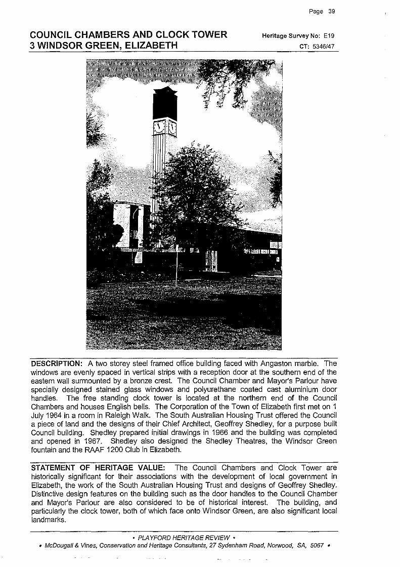
COUNCIL CHAMBERS AND CLOCK TOWER 3 WINDSOR GREEN, ELIZABETH
Page 39
Heritage Survey No: E19
CT: 5346/47
DESCRIPTION: A two storey steel framed office building faced with Angaston marble. The windows are evenly spaced in vertical strips with a reception door at the southern end of the eastern wall surmounted by a bronze crest. The Council Chamber and Mayor's Parlour have specially designed stained glass windows and polyurethane coated cast aluminium door handles. The free standing clock tower is located at the northern end of the Council Chambers and houses English bells. The Corporation of the Town of Elizabeth first met on 1 July 1964 in a room in Raleigh Walk. The South Australian Housing Trust offered the Council a piece of land and the designs of their Chief Architect, Geoffrey Shed ley, for a purpose built Council building. Shedley prepared initial drawings in 1966 and the building was completed and opened in 1967. Shedley also designed the Shedley Theatres, the Windsor Green fountain and the RAAF 1200 Club in Elizabeth.
STATEMENT OF HERITAGE VALUE: The Council Chambers and Clock Tower are historically significant for their associations with the development of local government in Elizabeth, the work of the South Australian Housing Trust and designs of Geoffrey Shedley. Distinctive design features on the building such as the door handles to the Council Chamber and Mayor's Parlour are also considered to be of historical interest. The building, and particularly the clock tower, both of which face onto Windsor Green, are also significant local landmarks.
• PLAYFORD HERITAGE REVIEW • • McDougall & Vines, Conservation and Heritage Consultants, 27 Sydenham Road, Norwood, SA, 5067 •
COUNCIL CHAMBERS AND CLOCK TOWER 3 WINDSOR GREEN, ELIZABETH (cont)
t"'age qu
RELEVANT CRITERIA: The Council Chambers and Clock Tower fulfil criteria a, c, d, e and f under Section 23(4) of the Development Act 1993 as a place of local heritage value.
EXTENT OF LISTING: The external form, materials and details of the original 1967 building including the free standing masonry Clock Tower.
SOURCES: • Danvers Architects, City of Elizabeth Heritage Survey, 1997
• PLAYFORD HERITAGE REVIEW • • McDougall & Vines, Conservation and Heritage Consultants, 27 Sydenham Road, Norwood, SA, 5067 •

GUERIN HOUSE 9/29 SPRUANCE ROAD, ELIZABETH EAST
Page 41
Heritage Survey No: E30
CT: 3898/27
DESCRIPTION: A late nineteenth century symmetrical stone cottage with brick dressings, side walls and chimneys. It retains a pitched corrugated iron roof, bull-nose verandah with turned timber posts, central front door with fan light and timber framed sash windows. Since the 1997 Survey flats have been constructed adjacent the cottage on what was originally garden. In 1911, Patrick Guerin owned several sections of land including Section 3121 on which this house stands. The land was purchased by the SA Housing Trust in 1957.
STATEMENT OF HERITAGE VALUE: This former farmhouse is significant as one of the few surviving reminders of Elizabeth's farming past and for its association with the Guerin family who owned much of the land on which Elizabeth is now built.
RELEVANT CRITERIA: This former farmhouse fulfils criteria a and b under Section 23(4) of the Development Act 1993 as a place of local heritage value.
EXTENT OF LISTING: The external form, materials and details of the original late nineteenth century cottage including bull-nose verandah, turned timber posts and original materials and detailing.
SOURCES: • Danvers Architects, City of Elizabeth Heritage Survey, 1997
• PLAYFORD HERITAGE REVIEW • • McDougall & Vines, Conservation and Heritage Consultants, 27 Sydenham Road, Norwood, SA, 5067 •
ELIZABETH GROVE UNITING CHURCH 85 FAIRFIELD ROAD, ELIZABETH GROVE
Page 42
Heritage Survey No: E33
CT: 2628/130
DESCRIPTION: A red brick hall style church constructed in 1956 which was designed as a combined church and hall. It has a corrugated iron roof, metal window frames glazed with amber glass. Internally the church retains timber floor and ceiling with steel trusses. There are two early light fittings and antique timber pews donated from an older church near Port Adelaide. The church is still used for many different activities as well as for religious services.
STATEMENT OF HERITAGE VALUE: The Elizabeth Grove Uniting Church is significant as the first church and also the first community hall to be built in the new town of Elizabeth.
RELEVANT CRITERIA: This church fulfils criteria a, b, c and d under Section 23(4) of the Development Act 1993 as a place of local heritage value.
EXTENT OF LISTING: The overall rectangular external forrn and detailing of the red brick section of the 1956 church. The besser block addition to the rear does not forrn part of this listing.
SOURCES: • Danvers Architects, City of Elizabeth Heritage Survey, 1997
• PLAYFORD HERITAGE REVIEW • • McDougall & Vines, Conservation and Heritage Consultants, 27 Sydenham Road, Norwood, SA, 5067 •
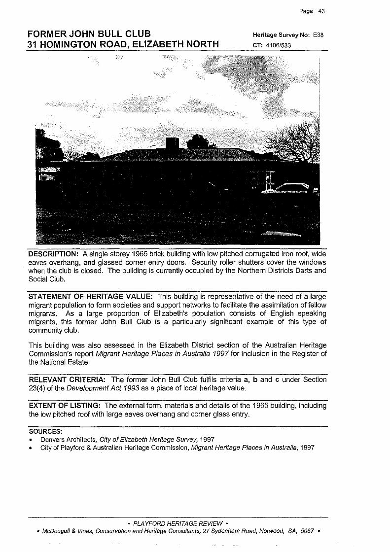
FORMERJOHNBULLCLUB 31 HOMINGTON ROAD, ELIZABETH NORTH
Page 43
Heritage Survey No: E38
CT: 4106/533
DESCRIPTION: A single storey 1965 brick building with low pitched corrugated iron roof, wide eaves overhang, and glassed corner entry doors. Security roller shutters cover the windows when the club is closed. The building is currently occupied by the Northern Districts Darts and Social Club.
STATEMENT OF HERITAGE VALUE: This building is representative of the need of a large migrant population to forrn societies and support networks to facilitate the assimilation of fellow migrants. As a large proportion of Elizabeth's population consists of English speaking migrants, this former John Bull Club is a particularly significant example of this type of community club.
This building was also assessed in the Elizabeth District section of the Australian Heritage Commission's report Migrant Heritage Places in Australia 1997 for inclusion in the Register of the National Estate.
RELEVANT CRITERIA: The former John Bull Club fulfils criteria a, b and c under Section 23(4) of the Development Act 1993 as a place of local heritage value.
EXTENT OF LISTING: The external form, materials and details of the 1965 building, including the low pitched roof with large eaves overhang and corner glass entry.
SOURCES: • Danvers Architects, City of Elizabeth Heritage Survey, 1997 • City of Playford & Australian Heritage Commission, Migrant Heritage Places in Australia, 1997
• PLAYFORD HERITAGE REVIEW • • McDougall & Vines, Conservation and Heritage Consultants, 27 Sydenham Road, Norwood, SA, 5067 •

OLIVE GROVE 40 SHILLABEER ROAD, ELIZABETH PARK
Page 44
Heritage Survey No: E48
CT: 2921/143
DESCRIPTION: An olive grove planted during the early twentieth century by Richard Judd on what was then farming land. Judd purchased the land in 1910. This olive grove covers much
·of Section 3133, and was purchased by the SA Housing Trust in 1950 and forms part of the public open space in Elizabeth Park.
STATEMENT OF HERITAGE VALUE: The Olive Grove is significant as one of the few surviving reminders of the farming activity that took place on the Elizabeth site before the city was founded.
RELEVANT CRITERIA: This Olive Grove fulfils criteria a and b under Section 23(4) of the Development Act 1993 as a place of local heritage value.
EXTENT OF LISTING: The area of land containing closely planted Olive Trees and steep sided creek.
SOURCES: • Danvers Architects, City of Elizabeth Heritage Survey, 1997 • L TO title records
• PLAYFORD HERITAGE REVIEW • • McDougall & Vines, Conservation and Heritage Consultants, 27 Sydenham Road, Norwood, SA, 5067 •

WATER TOWER 4 KETTERING ROAD, ELIZABETH SOUTH
Page 45
Heritage Survey No: E57
CT: 19353/2
DESCRIPTION: A six level circa 1940 water tower constructed of reinforced concrete, with vertical slit windows and a projecting cylindrical water tank at top. The tower was constructed to provide water for the munitions factory located near by.
STATEMENT OF HERITAGE VALUE: The Water Tower is significant as one of the few structures within the City of Elizabeth which dates from before the foundation of the City, and the only structure associated with World War Two. It is also significant for its associations with the munitions factory in Salisbury, and for its strong landmark characteristics.
RELEVANT CRITERIA: This Water Tower fulfils criteria a and f under Section 23(4) of the Development Act 1993 as a place of local heritage value.
EXTENT OF LISTING: The external forrn, materials and details of the original circa 1940 Water Tower including reinforced concrete and vertical slit windows.
SOURCES: • Danvers Architects, City of Elizabeth Heritage Survey, 1997
• PLAYFORD HERITAGE REVIEW • • McDougall & Vines, Conservation and Heritage Consultants, 27 Sydenham Road, Norwood, SA, 5067 •

GENERAL MOTORS HOLDENS OFFICE BUILDING 180 PHILIP HIGHWAY, ELIZABETH SOUTH
Page 46
Heritage Survey No: E60
CT: 5351/418
DESCRIPTION: A two storey symmetrical 1960s office building constructed of reinforced concrete, steel and glass. The east fagade has a central entrance with projecting porch at ground floor level, above which is a substantial panel carrying an enlarged version of the GMH logo. To the front elevation there is a continuous horizontal band of metal framed windows to both floors with rows of tiles applied beneath the windows. The first building at the GMH factory was erected in 1958.
STATEMENT OF HERITAGE VALUE: The General Motors Holden factory complex is Elizabeth's most significant industrial complex and has played a crucial role in the development of the city. The administrative building at the front of the General Motors Holden site is important for its representative associations with that significant site and its architectural style.
This building was also assessed in the Elizabeth District section of the Australian Heritage Commission's report Migrant Heritage Places in Australia 1997for inclusion in the Register of the National Estate.
RELEVANT CRITERIA: The General Motors Holden Office Building fulfils criteria a, b, c, d and f under Section 23(4) of the Development Act 1993 as a place of local heritage value.
EXTENT OF LISTING: The external form, materials and details of the 1960s building including tiled and glass fagade, projecting entrance with newer Holden logo, flat roof, projecting porch entry.
SOURCES: • Danvers Architects, City of Elizabeth Heritage SuNey, 1997 • City of Playford & Australian Heritage Commission, Migrant Heritage Places in Australia, 1997
• PLAYFORD HERITAGE REVIEW • • McDougall & Vines, Conservation and Heritage Consultants, 27 Sydenham Road, Norwood, SA, 5067 •
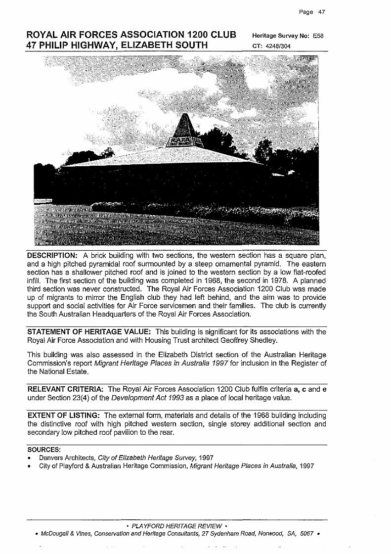
ROYAL AIR FORCES ASSOCIATION 1200 CLUB 47 PHILIP HIGHWAY, ELIZABETH SOUTH
Page 47
Heritage Survey No: E58
CT: 4248/304
DESCRIPTION: A brick building with two sections, the western section has a square plan, and a high pitched pyramidal roof surmounted by a steep ornamental pyramid. The eastern section has a shallower pitched roof and is joined to the western section by a low flat-roofed infill. The first section of the building was completed in 1968, the second in 1978. A planned third section was never constructed. The Royal Air Forces Association 1200 Club was made up of migrants to mirror the English club they had left behind, and the aim was to provide support and social activities for Air Force servicemen and their families. The club is currently the South Australian Headquarters of the Royal Air Forces Association.
STATEMENT OF HERITAGE VALUE: This building is significant for its associations with the Royal Air Force Association and with Housing Trust architect Geoffrey Shed ley.
This building was also assessed in the Elizabeth District section of the Australian Heritage Commission's report Migrant Heritage Places in Australia 1997 for inclusion in the Register of the National Estate.
RELEVANT CRITERIA: The Royal Air Forces Association 1200 Club fulfils criteria a, c and e under Section 23(4) of the Development Act 1993 as a place of local heritage value.
EXTENT OF LISTING: The external form, materials and details of the 1968 building including the distinctive roof with high pitched western section, single storey additional section and secondary low pitched roof pavilion to the rear.
SOURCES: • Danvers Architects, City of Elizabeth Heritage Survey, 1997 • City of Playford & Australian Heritage Commission, Migrant Heritage Places in Australia, 1997
• PLAYFORD HERITAGE REVIEW • • McDougall & Vines, Conservation and Heritage Consultants, 27 Sydenham Road, Norwood, SA, 5067 •

ROTUNDA, LYELL McEWIN HOSPITAL 130 HAYDOWN ROAD, ELIZABETH VALE
Page 48
Heritage Survey No: E67
CT: 5231/323
DESCRIPTION: Designed by Housing Trust architect Geoffrey Shedley as part of the Lyell McEwin hospital complex and completed c1958, this is a single storey round cement block building with projecting radiating buttress walls supporting overhanging eaves of reinforced concrete roof. The eaves project from a flat roof, which is covered by steel decking. Each bay has a row of steel framed windows, beneath which is a tiled concrete window box. The rotunda was originally built as a training area for nurses from the nearby hospital.
STATEMENT OF HERITAGE VALUE: The rotunda has been little altered since its construction as part of the original Lyell McEwin hospital complex, designed by Geoffrey Shedley. It is significant as a representative of the hospital which was a major early project of the South Australian Housing Trust, and which has been of significance to the community of Elizabeth and beyond.
RELEVANT CRITERIA: The rotunda at the Lyell McEwin Hospital fulfils criteria a, c and e under Section 23(4) of the Development Act 1993 as a place of local heritage value.
EXTENT OF LISTING: The overall circular form of the 1957-59 building including recessed windows and door entries, flat roof and tiled walls to window boxes.
SOURCES: • Danvers Architects, City of Elizabeth Heritage Survey, 1997
• PLAYFORD HERITAGE REVIEW • • McDougall & Vines, Conservation and Heritage Consultants, 27 Sydenham Road, Norwood, SA, 5067 •
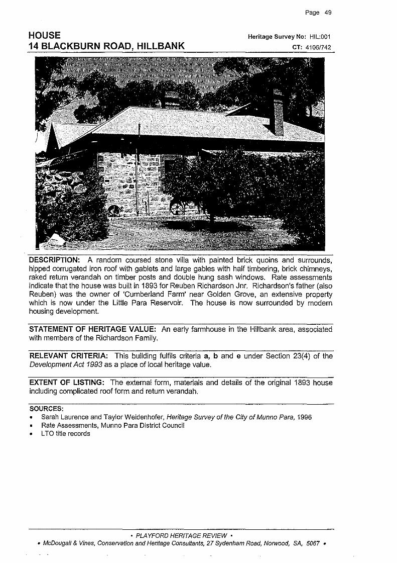
HOUSE 14 BLACKBURN ROAD, HILLBANK
Page 49
Heritage Survey No: HIL:001
CT: 4106/742
DESCRIPTION: A random coursed stone villa with painted brick quoins and surrounds, hipped corrugated iron roof with gablets and large gables with half timbering, brick chimneys, raked return verandah on timber posts and double hung sash windows. Rate assessments indicate that the house was built in 1893 for Reuben Richardson Jnr. Richardson's father (also Reuben) was the owner of 'Cumberland Farm' near Golden Grove, an extensive property which is now under the Little Para Reservoir. The house is now surrounded by modern housing development.
STATEMENT OF HERITAGE VALUE: An early farmhouse in the Hillbank area, associated with members of the Richardson Family.
RELEVANT CRITERIA: This building fulfils criteria a, b and e under Section 23(4) of the Development Act 1993 as a place of local heritage value.
EXTENT OF LISTING: The external form, materials and details of the original 1893 house including complicated roof form and return verandah.
SOURCES: • Sarah Laurence and Taylor Weidenhofer, Heritage Survey of the City of Munno Para, 1996 • Rate Assessments, Munno Para District Council • L TO title records
• PLAYFORD HERITAGE REVIEW • • McDougall & Vines, Conse!Vation and Heritage Consultants, 27 Sydenham Road, Norwood, SA, 5067 •
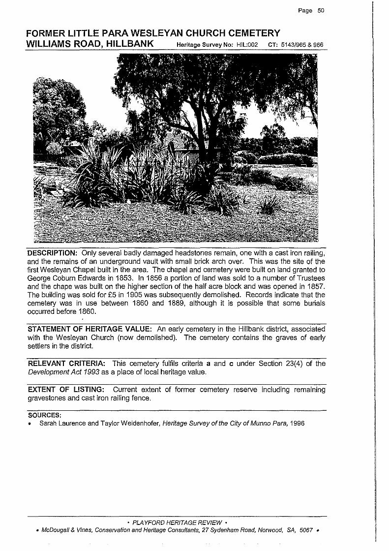
Page 50
FORMER LITTLE PARA WESLEYAN CHURCH CEMETERY WILLIAMS ROAD, HILLBANK Heritage Survey No: HIL:002 CT: 51431965 & 966
DESCRIPTION: Only several badly damaged headstones remain, one with a cast iron railing, and the remains of an underground vault with small brick arch over. This was the site of the first Wesleyan Chapel built in the area. The chapel and cemetery were built on land granted to George Coburn Edwards in 1853. In 1856 a portion of land was sold to a number of Trustees and the chape was built on the higher section of the half acre block and was opened in 1857. The building was sold for £5 in 1905 was subsequently demolished. Records indicate that the cemetery was in use between 1860 and 1889, although it is possible that some burials occurred before 1860.
STATEMENT OF HERITAGE VALUE: An early cemetery in the Hillbank district, associated with the Wesleyan Church (now demolished). The cemetery contains the graves of early settlers in the district.
RELEVANT CRITERIA: This cemetery fulfils criteria a and c under Section 23(4) of the Development Act 1993 as a place of local heritage value.
EXTENT OF LISTING: Current extent of former cemetery reserve including remaining gravestones and cast iron railing fence.
SOURCES: • Sarah Laurence and Taylor Weidenhofer, Heritage Survey of the City of Munno Para, 1996
• PLAYFORD HERITAGE REVIEW • • McDougall & Vines, Conservation and Heritage Consultants, 27 Sydenham Road, Norwood, SA, 5067 •

HOUSE 110 HILLIER ROAD, HILLIER
Page 51
Heritage Survey No: HLR:001
CT: 4091/991
DESCRIPTION: A random rubble stone house with brick quoins, surrounds and string course. There is a (originally double) gabled corrugated iron roof with brick chimneys, later bull-nose verandah on turned timber posts, double hung sash windows and associated random rubble stone outbuildings. The land on which the cottage stands was granted to Thomas Higgins in 1853. Higgins owned more than 700 acres in the Hundred of Munno Para between 1846 and 1853. In 1865 Higgins leased the land to Robert McPherson and rate assessments indicate a house on the property for the first time in that year. In 1924 the property was inherited by William Stuart Bright. This house may be the only one remaining from the Gawler Blocks subdivision in the late 19111 Century.
STATEMENT OF HERITAGE VALUE: An early farmhouse on the Gawler River, associated with members of the Higgins family, early settler and land holders in the area.
RELEVANT CRITERIA: This house fulfils criteria a, b and e under Section 23(4) of the Development Act 1993 as a place of local heritage value.
EXTENT OF LISTING: The external form, materials and details of the original1865 cottage.
SOURCES: • Sarah Laurence and Taylor Weidenhofer, Heritage Survey of the City of Munno Para, 1996 • Rate Assessments, Munno Para West District Council1854-1885
• PLAYFORD HERITAGE REVIEW • • McDougall & Vines, Conservation and Heritage Consultants, 27 Sydenham Road, Norwood, SA, 5067 •
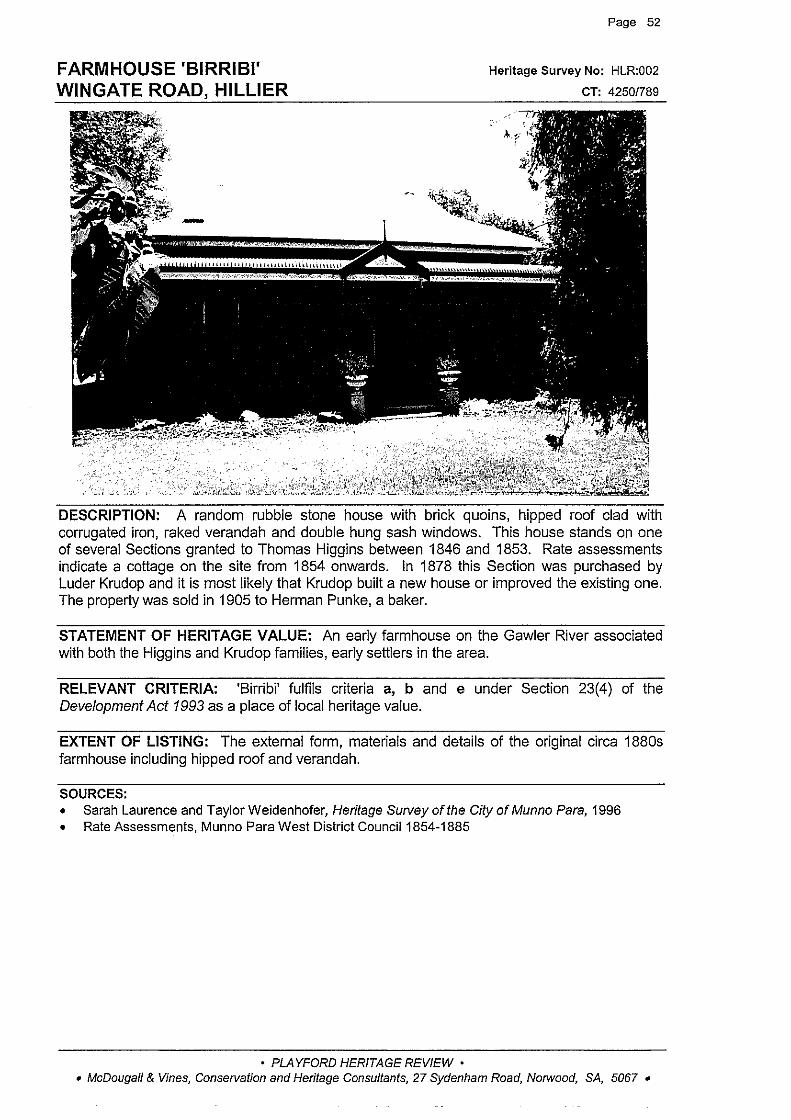
FARMHOUSE 'BIRRIBI' WINGATE ROAD, HILLIER
Page 52
Heritage Survey No: HLR:002
CT: 4250/789
DESCRIPTION: A random rubble stone house with brick quoins, hipped roof clad with corrugated iron, raked verandah and double hung sash windows. This house stands on one of several Sections granted to Thomas Higgins between 1846 and 1853. Rate assessments indicate a cottage on the site from 1854 onwards. In 1878 this Section was purchased by Luder Krudop and it is most likely that Krudop built a new house or improved the existing one. The property was sold in 1905 to Herman Punke, a baker.
STATEMENT OF HERITAGE VALUE: An early farmhouse on the Gawler River associated with both the Higgins and Krudop families, early settlers in the area.
RELEVANT CRITERIA: 'Birribi' fulfils criteria a, b and e under Section 23(4) of the Development Act 1993 as a place of local heritage value.
EXTENT OF LISTING: The external form, materials and details of the original circa 1880s farmhouse including hipped roof and verandah.
SOURCES: • Sarah Laurence and Taylor Weidenhofer, Heritage Survey of the City of Munno Para, 1996 • Rate Assessments, Munno Para West District Council1854-1885
• PLAYFORD HERITAGE REVIEW • • McDougall & Vines, Conservation and Heritage Consultants, 27 Sydenham Road, Norwood, SA, 5067 •
Page 53
STONE BARN AND OUTBUILDINGS 'TREVILLA' Heritage Survey No: HUM:001
KERSBROOK ROAD, HUMBUG SCRUB cT: 4267/824
No photograph
DESCRIPTION: This property was formerly owned by Henry Blackham, who had arrived in South Australia from Northern Ireland in 1840. He built the house 'Trevilla' in the 1850s.
STATEMENT OF HERITAGE VALUE: These outbuildings are associated with the original 'Trevilla' house and property, built and owned by Henry Hamilton Blackham, an early settler in the district. His son, also Henry, was active in the Munno Para East and Para Wirra District Councils. However the house no longer exists and the outbuildings could not be inspected.
RECOMMENDATION: These buildings are not recommended for listing.
SOURCES: • Sarah Laurence and Taylor Weidenhofer, Heritage Survey of the City of Munno Para, 1996
• PLAYFORD HERITAGE REVIEW • • McDougall & Vines, Conservation and Heritage Consultants, 27 Sydenham Road, Norwood, SA, 5067 •

HOUSE 'SUNNYBRAE' TAYLORS ROAD, HUMBUG SCRUB
Page 54
Heritage Survey No: HUM:002
CT: 4066/429
DESCRIPTION: A random coursed stone house with brick quoins and surrounds, hipped corrugated iron roof with brick chimney, bull-nose verandah on timber posts with lattice to ends, and double hung sash windows. There is a skillion addition to the rear. The land on which this house is built was once part of an Aboriginal reserve and supplies were distributed from here to the local Aboriginals. The reserve land was subsequently rented to farmers and divided up into workers blocks. The house was built by George Taylor, a horse dentist, who owned the land around the house as well as 40 to 50 acres near Uley Chapel. Taylor purchased this land in 1912, although it is likely he was associated with the property before this time.
STATEMENT OF HERITAGE VALUE: A small farmhouse in the area, associated with members of the Taylor family.
RELEVANT CRITERIA: This house fulfils criteria a, b and e under Section 23(4) of the Development Act 1993 as a place of local heritage value.
EXTENT OF LISTING: The external forrn, materials and details of the original house including low hipped roof, bull-nose verandah and rear skillion additions.
SOURCES: • Sarah Laurence and Taylor Weidenhofer, Heritage Swvey of the City of Munno Para, 1996
• PLAYFORD HERITAGE REVIEW • • McDougall & Vines, Conservation and Heritage Consultants, 27 Sydenham Road, Norwood, SA, 5067 •
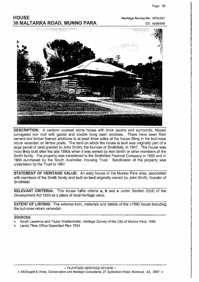
HOUSE 36 MALTARRA ROAD, MUNNO PARA
Page 55
Heritage Survey No: MPA:001
CT: 4098/695
' '
'
""' ~' ,_, fl 'I
DESCRIPTION: A random coursed stone house with brick quoins and surrounds, hipped corrugated iron roof with gablet and double hung sash windows, There have been fibre cement and timber framed additions to at least three sides of the house filling in the bull-nose return verandah on timber posts. The land on which the house is built was originally part of a large parcel of land granted to John Smith, the founder of Smithfield, in 1847. The house was most likely built after the late 1880s when it was owned by Ann Smith or other members of the Smith family. The property was transferred to the Smithfield Pastoral Company in 1955 and in 1960 purchased by the South Australian Housing Trust Subdivision of the property was undertaken by the Trust in 1967.
STATEMENT OF HERITAGE VALUE: An early house in the Munno Para area, associated with members of the Smith family and built on land originally owned by John Smith, founder of Smithfield.
RELEVANT CRITERIA: This house fulfils criteria a, b and e under Section 23(4) of the Development Act 1993 as a place of local heritage value.
EXTENT OF LISTING: The external form, materials and details of the c1890 house including the bull-nose return verandah.
SOURCES: • Sarah Laurence and TaylorWeidenhofer, Heritage Swveyofthe CityofMunno Para, 1996 • Lands Titles Office Deposited Plan 7954
• PLAYFORD HERITAGE REVIEW • • McDougall & Vines, Conservation and Heritage Consultants, 27 Sydenham Road, Norwood, SA, 5067 •
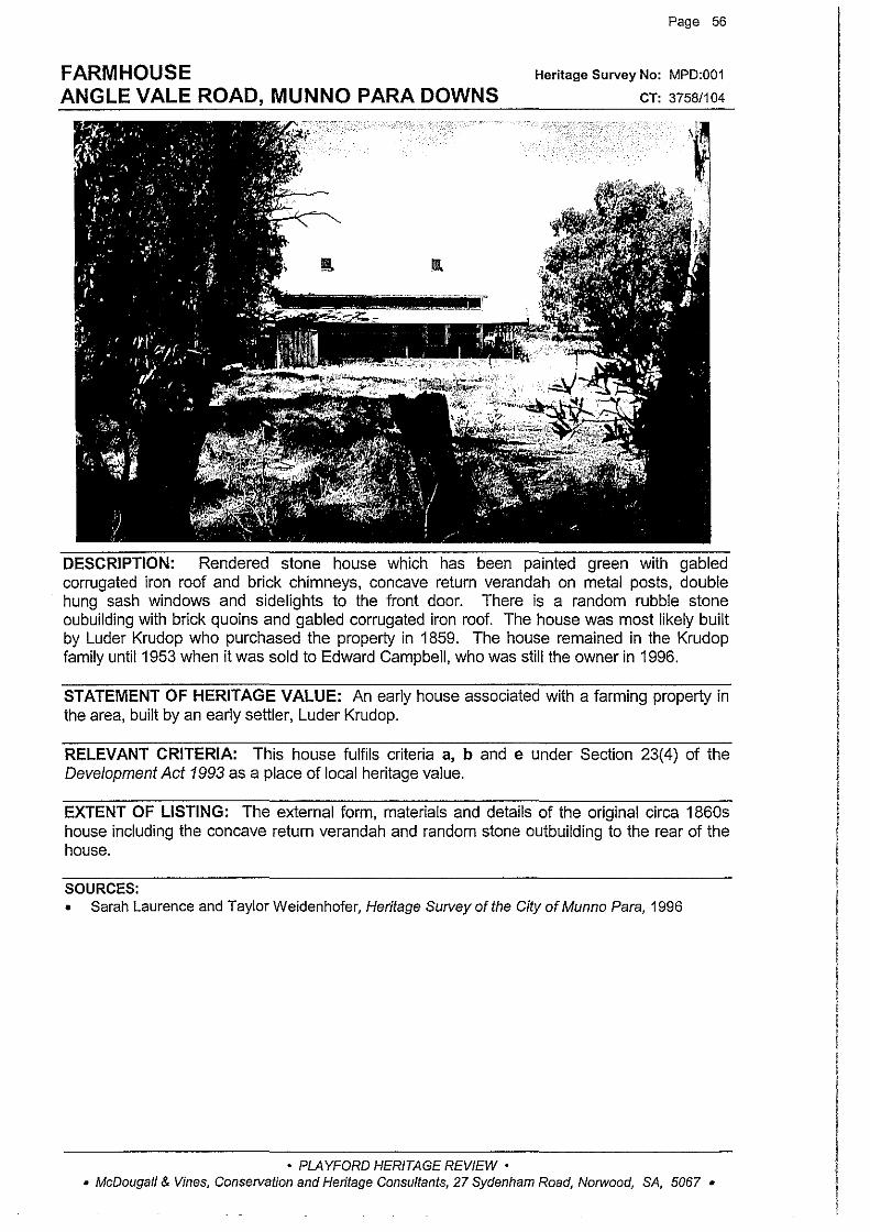
FARMHOUSE ANGLE VALE ROAD, MUNNO PARA DOWNS
Page 56
Heritage Survey No: MPD:001
CT: 3758/104
DESCRIPTION: Rendered stone house which has been painted green with gabled corrugated iron roof and brick chimneys, concave return verandah on metal posts, double hung sash windows and sidelights to the front door. There is a random rubble stone oubuilding with brick quoins and gabled corrugated iron roof. The house was most likely built by Luder Krudop who purchased the property in 1859. The house remained in the Krudop family until1953 when it was sold to Edward Campbell, who was still the owner in 1996.
STATEMENT OF HERITAGE VALUE: An early house associated with a farming property in the area, built by an early settler, Luder Krudop.
RELEVANT CRITERIA: This house fulfils criteria a, b and e under Section 23(4) of the Development Act 1993 as a place of local heritage value.
EXTENT OF LISTING: The external form, materials and details of the original circa 1860s house including the concave return verandah and random stone outbuilding to the rear of the house.
SOURCES: • Sarah Laurence and Taylor Weidenhofer, Heritage Survey of the City of Munno Para, 1996
• PLAYFORD HERITAGE REVIEW • • McDougall & Vines, Conservation and Heritage Consultants, 27 Sydenham Road, Norwood, SA, 5067 •
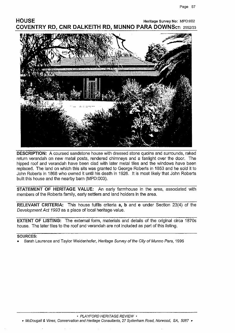
Page 57
HOUSE Heritage Survey No: MPD:002
COVENTRY RD, CNR DALKEITH RD, MUNNO PARA DOWNScT: 2552133
DESCRIPTION: A coursed sandstone house with dressed stone quoins and surrounds, raked return verandah on new metal posts, rendered chimneys and a fanlight over the door. The hipped roof and verandah have been clad with later metal tiles and the windows have been replaced. The land on which this sits was granted to George Roberts in 1853 and he sold it to John Roberts in 1868 who owned it until his death in 1926. It is most likely that John Roberts built this house and the nearby barn (MPD:003).
STATEMENT OF HERITAGE VALUE: An early farmhouse in the area, associated with members of the Roberts family, early settlers and land holders in the area.
RELEVANT CRITERIA: This house fulfils criteria a, b and e under Section 23(4) of the Development Act 1993 as a place of local heritage value.
EXTENT OF LISTING: The external form, materials and details of the original circa 1870s house. The later tiles to the roof and verandah are not included as part of this listing.
SOURCES: • Sarah Laurence and Taylor Weidenhofer, Heritage Survey of the City of Munno Para, 1996
• PLAYFORD HERITAGE REVIEW • • McDougall & Vines, Conservation and Heritage Consultants, 27 Sydenham Road, Norwood, SA, 5067 •
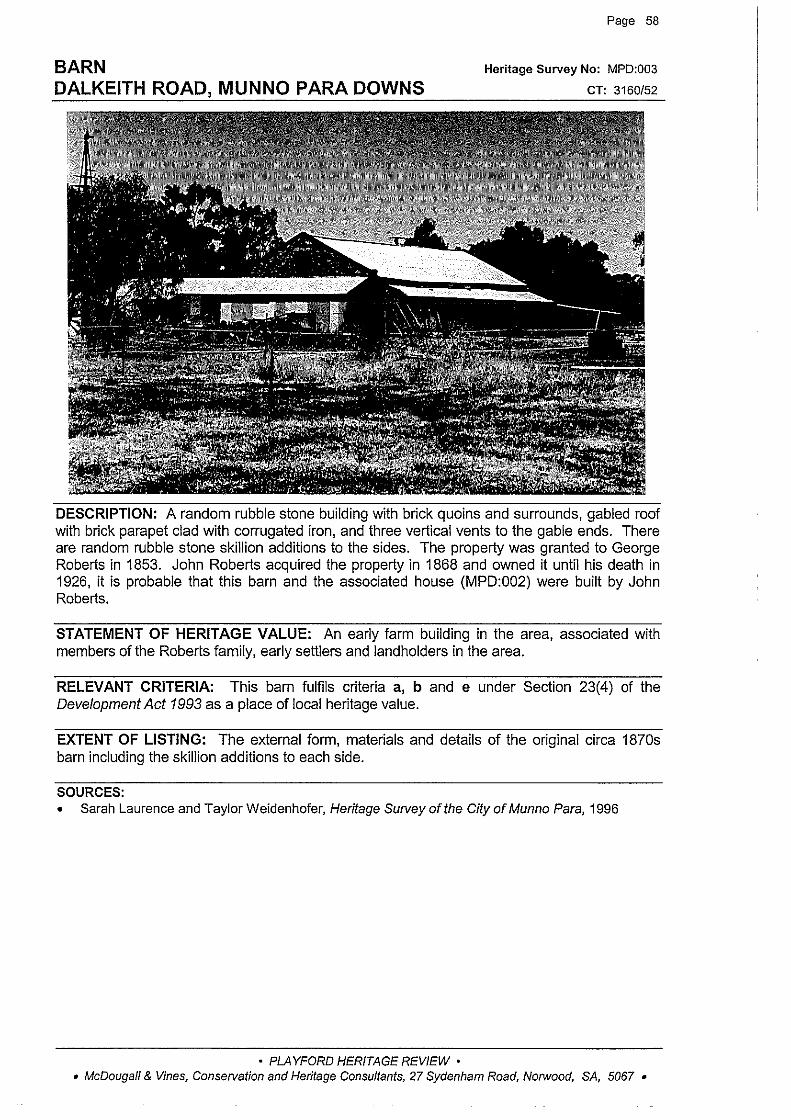
BARN DALKEITH ROAD, MUNNO PARA DOWNS
Page 58
Heritage Survey No: MPD:003
CT: 3160/52
DESCRIPTION: A random rubble stone building with brick quoins and surrounds, gabled roof with brick parapet clad with corrugated iron, and three vertical vents to the gable ends. There are random rubble stone skillion additions to the sides. The property was granted to George Roberts in 1853. John Roberts acquired the property in 1868 and owned it until his death in 1926, it is probable that this barn and the associated house (MPD:002) were built by John Roberts.
STATEMENT OF HERITAGE VALUE: An early farm building in the area, associated with members of the Roberts family, early settlers and landholders in the area.
RELEVANT CRITERIA: This barn fulfils criteria a, b and e under Section 23(4) of the Development Act 1993 as a place of local heritage value.
EXTENT OF LISTING: The external form, materials and details of the original circa 1870s barn including the skillion additions to each side.
SOURCES: • Sarah Laurence and Taylor Weidenhofer, Heritage Survey of the City of Munno Para, 1996
• PLAYFORD HERITAGE REVIEW • • McDougall & Vines, Conservation and Heritage Consultants, 27 Sydenham Road, Norwood, SA, 5067 •
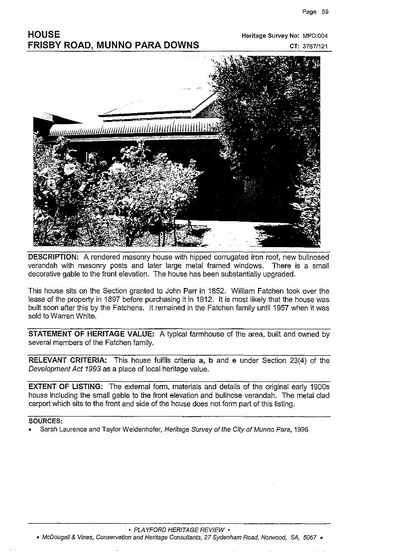
HOUSE FRISBY ROAD, MUNNO PARA DOWNS
Page 59
Heritage Survey No: MPD:004
CT: 3767/121
DESCRIPTION: A rendered masonry house with hipped corrugated iron roof, new bullnosed verandah with masonry posts and later large metal framed windows. There is a small decorative gable to the front elevation. The house has been substantially upgraded.
This house sits on the Section granted to John Parr in 1852. William Fatchen took over the lease of the property in 1897 before purchasing it in 1912. It is most likely that the house was built soon after this by the Fatchens. It remained in the Fatchen family until 1957 when it was sold to Warren White.
STATEMENT OF HERITAGE VALUE: A typical farmhouse of the area, built and owned by several members of the Fatchen family.
RELEVANT CRITERIA: This house fulfils criteria a, b and e under Section 23(4) of the Development Act 1993 as a place of local heritage value.
EXTENT OF LISTING: The external form, materials and details of the original early 1900s house including the small gable to the front elevation and bullnose verandah. The metal clad carport which sits to the front and side of the house does not form part of this listing.
SOURCES: • Sarah Laurence and Taylor Weidenhofer, Heritage Survey of the City of Munno Para, 1996
• PLAYFORD HERITAGE REVIEW • • McDougall & Vines, Conservation and Heritage Consultants, 27 Sydenham Road, No/Wood, SA, 5067 •

HOUSE FRISBY ROAD, MUNNO PARA DOWNS
Page 60
Heritage Survey No: MPD:005
CT: 4035/784
DESCRIPTION: A low-scale early house with gabled corrugated iron roof and raked verandah. The walls are rendered pise (earth and straw) construction showing typical signs of deterioration. The rear of the house extends in a distinctive skillion form in pise. There is also a circular random rubble stone tank. The building is currently uninhabited. The property belonged to John Parr in 1852 and it is most likely that the Parr's built the cottage. The property was leased from 1893 to Richard Congdon, and then to a succession of farmers until the 1920s when the property was purchased by Cecil Fatchen. The Fatchen family owned the property until 1958 when it was split up and sold.
STATEMENT OF HERITAGE VALUE: This early pise farm building is associated John Parr, one of the first settlers in the area. It is a now rare example of this early form of pioneer building construction. The property was later to become the first in the area to be owned by members of the Fatchen family.
RELEVANT CRITERIA: This house fulfils criteria a, b, d and e under Section 23(4) of the Development Act 1993 as a place of local heritage value.
EXTENT OF LISTING: The external form, materials and details of the original circa 1850s house including the verandah.
SOURCES: • Sarah Laurence and Taylor Weidenhofer, Heritage Survey of the City of Munno Para, 1996 • Playford Local History Collection -research notes
View from rear
• PLAYFORD HERITAGE REVIEW • • McDougall & Vines, Conservation and Heritage Consultants, 27 Sydenham Road, Norwood, SA, 5067 •

HOUSE & OUTBUILDINGS 'STEBONHEATH' STEBONHEATH ROAD, MUNNO PARA DOWNS
Page 61
Heritage Survey No: MPD:006
CT: 4192/579
DESCRIPTION: A rendered and painted stone house with gabled corrugated iron roof, brick chimneys, raked verandah with timber posts and lace brackets, and double hung sash windows with tapered surrounds. There are random rubble stone and brick outbuildings. Thomas Adams purchased the property in 1856 and it is likely that either Thomas or his son David built the house. The property was sold to John Barrett in 1897, and George Andrews bought it in 1918. It remained in the Andrews family unti1197 4.
STATEMENT OF HERITAGE VALUE: Built by early pioneer farmers Thomas or David Adams, the house has been owned by members of the Andrews family for many years. It is representative of early farmhouses in the district.
RELEVANT CRITERIA: This house fulfils criteria a, b and e under Section 23(4) of the Development Act 1993 as a place of local heritage value.
EXTENT OF LISTING: The external form, materials and details of the original circa 1860s cottage and the stone outbuildings to the west of the property. The later corrugated iron sheds are not included in this listing.
SOURCES: • Sarah Laurence and Taylor Weidenhofer, Heritage Survey of the City of Munno Para, 1996
• PLAYFORD HERITAGE REVIEW • • McDougall & Vines, Conservation and Heritage Consultants, 27 Sydenham Road, Norwood, SA, 5067 •

HOUSE 'PEPPER TREE FARM' BRANDIS ROAD, MUNNO PARA WEST
Page 62
Heritage Survey No: MPW:001
CT: 4078/509
DESCRIPTION: A random coursed stone house with brick quoins, surrounds and string course, hipped corrugated iron roof with brick chimneys, double hung sash windows, sidelights and fanlight to front door, and a concave verandah on timber posts. There are the remains of a random rubble stone garden wall nearby and a random rubble stone and brick outbuilding to the rear. The house was most likely built by Ephraim Teakle some time after 1853.
STATEMENT OF HERITAGE VALUE: An early farmhouse in the area, representing the rural development of the district prior to subdivision.
RELEVANT CRITERIA: This house fulfils criteria a and b under Section 23(4) of the Development Act 1993 as a place of local heritage value.
EXTENT OF LISTING: The external form, materials and details of the original circa 1860s house including the simple concave verandah form.
SOURCES: • Sarah Laurence and Taylor Weidenhofer, Heritage Survey of the City of Munno Para, 1996
• PLAYFORD HERITAGE REVIEW • • McDougall & Vines, Conservation and Heritage Consultants, 27 Sydenham Road, Norwood, SA, 5067 •
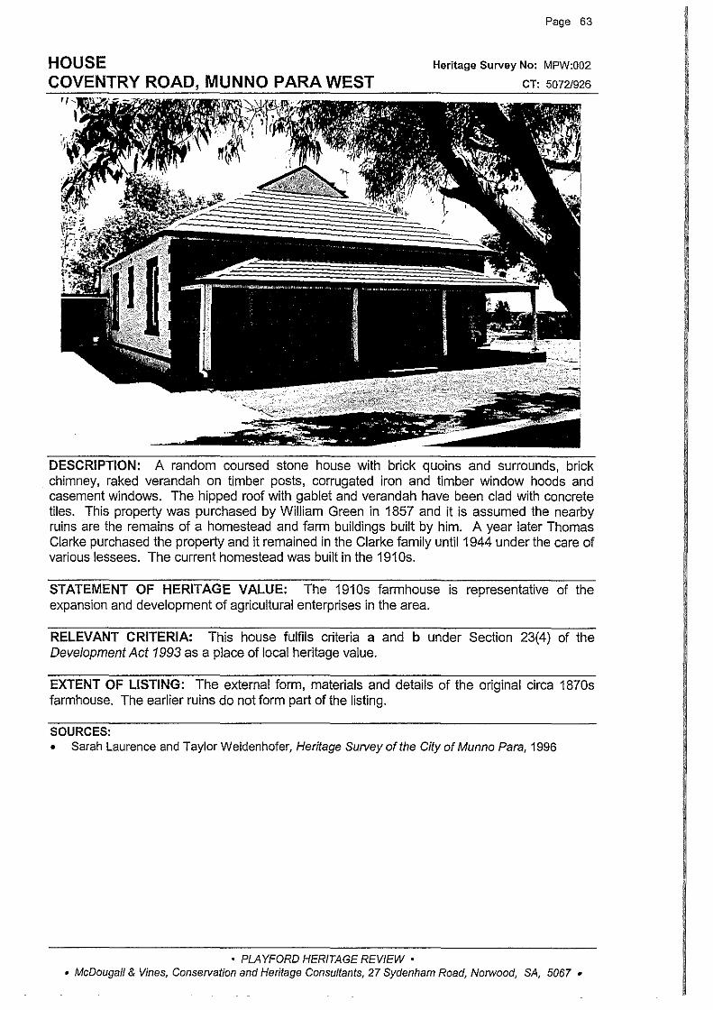
Page 63
Heritage Survey No: MPW:002
CT: 5072/926
DESCRIPTION: A random coursed stone house with brick quoins and surrounds, brick chimney, raked verandah on timber posts, corrugated iron and timber window hoods and casement windows. The hipped roof with gablet and verandah have been clad with concrete tiles. This property was purchased by William Green in 1857 and it is assumed the nearby ruins are the remains of a homestead and farm buildings built by him. A year later Thomas Clarke purchased the property and it remained in the Clarke family until 1944 under the care of various lessees. The current homestead was built in the 191 Os.
STATEMENT OF HERITAGE VALUE: The 1910s farmhouse is representative of the expansion and development of agricultural enterprises in the area.
RELEVANT CRITERIA: This house fulfils criteria a and b under Section 23(4) of the Development Act 1993 as a place of local heritage value.
EXTENT OF LISTING: The external form, materials and details of the original circa 1870s farmhouse. The earlier ruins do not form part of the listing.
SOURCES: • Sarah Laurence and Taylor Weidenhofer, Heritage Survey of the City of Munno Para, 1996
• PLAYFORD HERITAGE REVIEW • • McDougall & Vines, Conservation and Heritage Consultants, 27 Sydenham Road, Norwood, SA, 5067 •
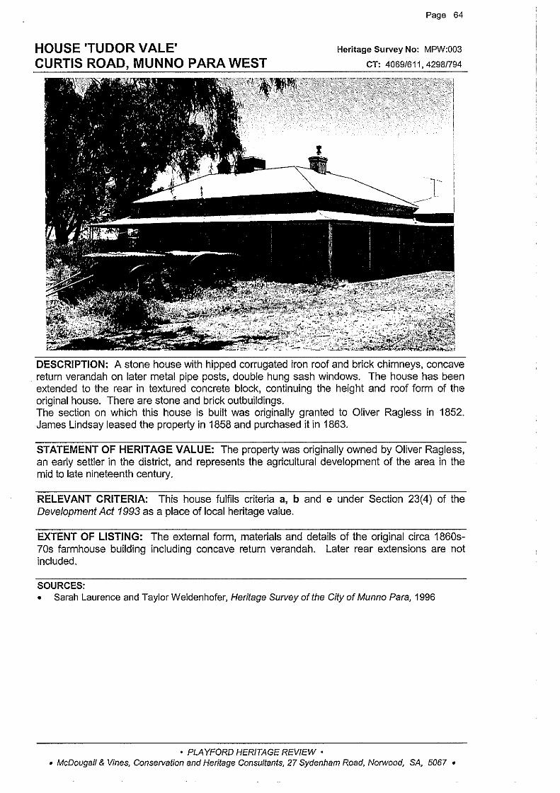
HOUSE 'TUDOR VALE' CURTIS ROAD, MUNNO PARA WEST
Page 64
Heritage Survey No: MPW:003
CT: 4069/611, 4298/794
T
DESCRIPTION: A stone house with hipped corrugated iron roof and brick chimneys, concave return verandah on later metal pipe posts, double hung sash windows. The house has been extended to the rear in textured concrete block, continuing the height and roof form of the original house. There are stone and brick outbuildings. The section on which this house is built was originally granted to Oliver Ragless in 1852. James Lindsay leased the property in 1858 and purchased it in 1863.
STATEMENT OF HERITAGE VALUE: The property was originally owned by Oliver Ragless, an early settler in the district, and represents the agricultural development of the area in the mid to late nineteenth century.
RELEVANT CRITERIA: This house fulfils criteria a, b and e under Section 23(4) of the Development Act 1993 as a place of local heritage value.
EXTENT OF LISTING: The external form, materials and details of the original circa 1860s-70s farmhouse building including concave return verandah. Later rear extensions are not included.
SOURCES: • Sarah Laurence and Taylor Weidenhofer, Heritage Survey of the City of Munno Para, 1996
• PLAYFORD HERITAGE REVIEW • • McDougall & Vines, Conservation and Heritage Consultants, 27 Sydenham Road, Norwood, SA, 5067 •
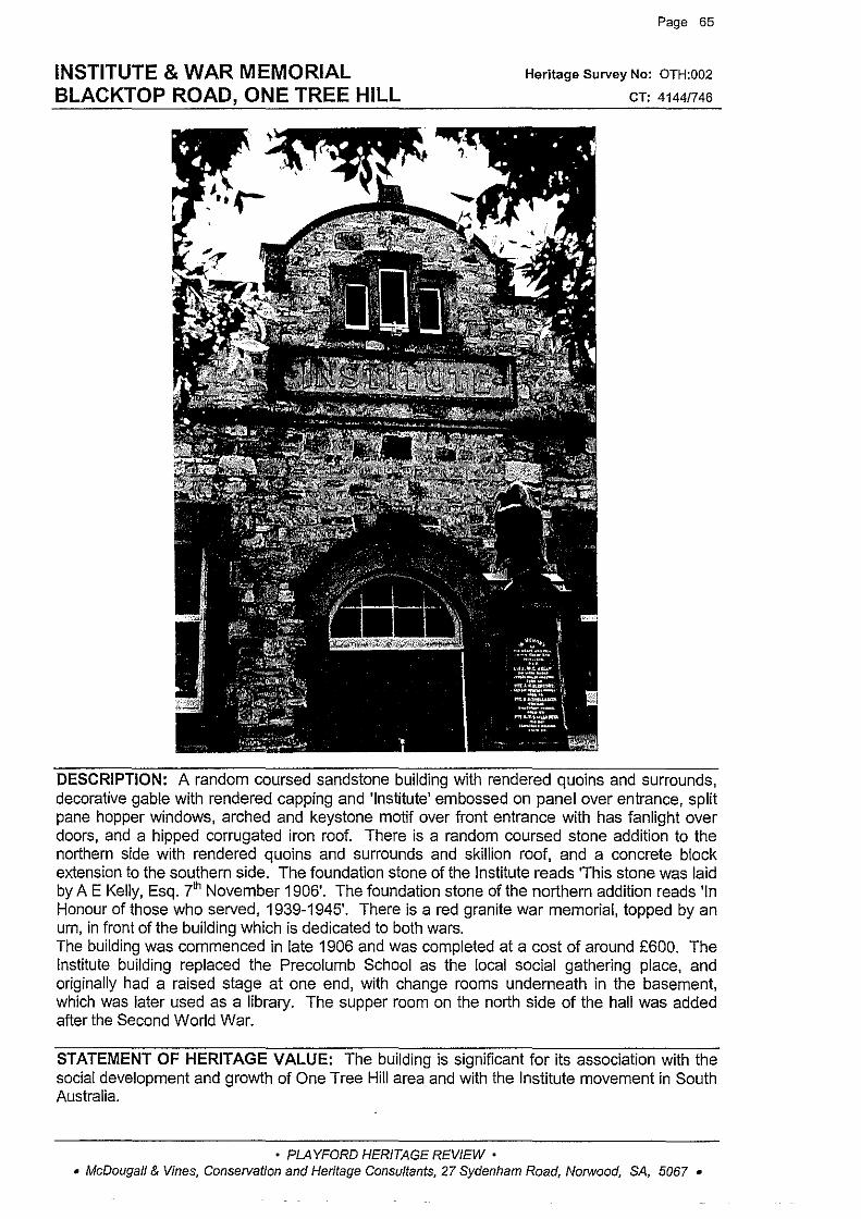
INSTITUTE & WAR MEMORIAL BLACKTOP ROAD, ONE TREE HILL
Page 65
Heritage Survey No: OTH:002
CT: 4144/746
DESCRIPTION: A random coursed sandstone building with rendered quoins and surrounds, decorative gable with rendered capping and 'Institute' embossed on panel over entrance, split pane hopper windows, arched and keystone motif over front entrance with has fanlight over doors, and a hipped corrugated iron roof. There is a random coursed stone addition to the northern side with rendered quoins and surrounds and skillion roof, and a concrete block extension to the southern side. The foundation stone of the Institute reads 'This stone was laid by A E Kelly, Esq. 7'h November 1906'. The foundation stone of the northern addition reads 'In Honour of those who served, 1939-1945'. There is a red granite war memorial, topped by an urn, in front of the building which is dedicated to both wars. The building was commenced in late 1906 and was completed at a cost of around £600. The Institute building replaced the Precolumb School as the local social gathering place, and originally had a raised stage at one end, with change rooms underneath in the basement, which was later used as a library. The supper room on the north side of the hall was added after the Second World War.
STATEMENT OF HERITAGE VALUE: The building is significant for its association with the social development and growth of One Tree Hill area and with the Institute movement in South Australia.
• PLAYFORD HERITAGE REVIEW • • McDougall & Vines, Consetvation and Heritage Consultants, 27 Sydenham Road, Norwood, SA, 5067 •
Page 66
INSTITUTE & WAR MEMORIAL BLACKTOP ROAD, ONE TREE HILL (cont)
RELEVANT CRITERIA: This Institute and War Memorial fulfils criteria a and c under Section 23( 4) of the Development Act 1993 as a place of local heritage value.
EXTENT OF LISTING: The external form, materials and details of the 1906 section of the building, the northern addition which was built after the Second World War, and the red granite War Memorial.
SOURCES: • Sarah Laurence and Taylor Weidenhofer, Heritage Survey of the City of Munno Para, 1996
• PLAYFORD HERITAGE REVIEW • • McDougall & Vines, Conservation and Heritage Consultants, 27 Sydenham Road, Norwood, SA, 5067 •
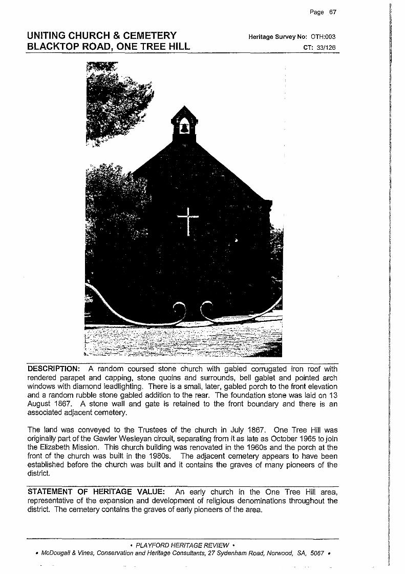
UNITING CHURCH & CEMETERY BLACKTOP ROAD, ONE TREE HILL
Page 67
Heritage Survey No: OTH:003
CT: 33/126
DESCRIPTION: A random coursed stone church with gabled corrugated iron roof with rendered parapet and capping, stone quoins and surrounds, bell gablet and pointed arch windows with diamond leadlighting. There is a small, later, gabled porch to the front elevation and a random rubble stone gabled addition to the rear. The foundation stone was laid on 13 August 1867. A stone wall and gate is retained to the front boundary and there is an associated adjacent cemetery.
The land was conveyed to the Trustees of the church in July 1867. One Tree Hill was originally part of the Gawler Wesleyan circuit, separating from it as late as October 1965 to join the Elizabeth Mission. This church building was renovated in the 1960s and the porch at the front of the church was built in the 1980s. The adjacent cemetery appears to have been established before the church was built and it contains the graves of many pioneers of the district.
STATEMENT OF HERITAGE VALUE: An early church in the One Tree Hill area, representative of the expansion and development of religious denominations throughout the district. The cemetery contains the graves of early pioneers of the area.
• PLAYFORD HERITAGE REVIEW • • McDougall & Vines, Conservation and Heritage Consultants, 27 Sydenham Road, Norwood, SA, 5067 •
UNITING CHURCH & CEMETERY BLACKTOP ROAD, ONE TREE HILL (cont)
Page 68
RELEVANT CRITERIA: This Church and cemetery fulfil criteria a and c under Section 23(4) of the Development Act 1993 as a place of local heritage value.
EXTENT OF LISTING: The external form, materials and details of the original 1860s church and the whole of the cemetery reserve.
SOURCES: • Sarah Laurence and Taylor Weidenhofer, Heritage Survey of the City of Munno Para, 1996
• PLAYFORD HERITAGE REVIEW • • McDougall & Vines, Conse!Vation and Heritage Consultants, 27 Sydenham Road, Norwood, SA, 5067 •
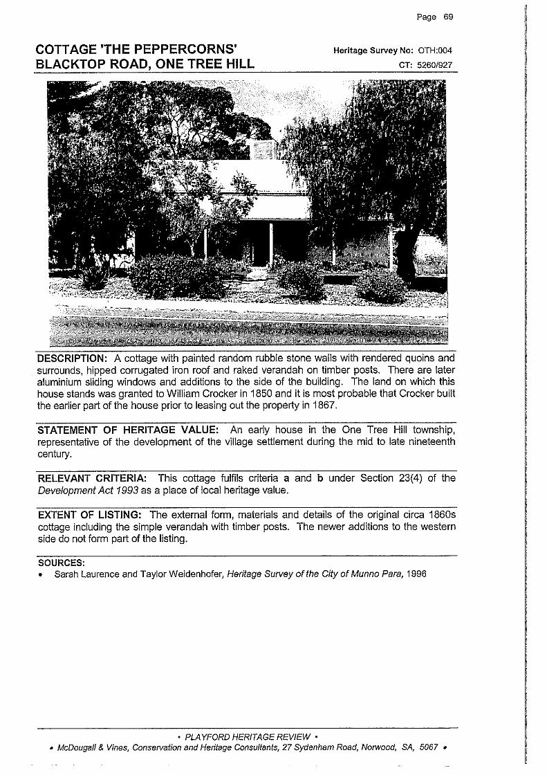
COTTAGE 'THE PEPPERCORNS' BLACKTOP ROAD, ONE TREE HILL
Page 69
Heritage Survey No: OTH:004
CT: 52601927
DESCRIPTION: A cottage with painted random rubble stone walls with rendered quoins and surrounds, hipped corrugated iron roof and raked verandah on timber posts. There are later aluminium sliding windows and additions to the side of the building. The land on which this house stands was granted to William Crocker in 1850 and it is most probable that Crocker built the earlier part of the house prior to leasing out the property in 1867.
STATEMENT OF HERITAGE VALUE: An early house in the One Tree Hill township, representative of the development of the village settlement during the mid to late nineteenth century.
RELEVANT CRITERIA: This cottage fulfils criteria a and b under Section 23(4) of the Development Act 1993 as a place of local heritage value.
EXTENT OF LISTING: The external form, materials and details of the original circa 1860s cottage including the simple verandah with timber posts. The newer additions to the western side do not form part of the listing.
SOURCES: • Sarah Laurence and Taylor Weidenhofer, Heritage Survey of the City of Munno Para, 1996
• PLAYFORD HERITAGE REVIEW • • McDougall & Vines, Conservation and Heritage Consultants, 27 Sydenham Road, Norwood, SA, 5067 •

FORMER ONE TREE HILL POST OFFICE BLACKTOP ROAD, ONE TREE HILL
Page 70
Heritage Survey No: OTH:005
CT: 5171/464
DESCRIPTION: This random rubble stone rear section of the building at this location is all that remains of the 1858 post office. The building incorporated the first Post Office in One Tree Hill and also a general store for the area. The early stone section, which has been painted, retains rendered quoins and surrounds, hipped corrugated iron roof and stone chimney. A new section was added to the front of the post office in the 1980s and the original rear section is only visible from the side of the property.
STATEMENT OF HERITAGE VALUE: The early 1850s section of the former Post Office building represents the establishment and growth of One Tree Hill as a township and the provision of communication services to the area.
RELEVANT CRITERIA: This former One Tree Hill Post Office fulfils criteria a and c under Section 23(4) of the Development Act 1993 as a place of local heritage value.
EXTENT OF LISTING: The external form, materials and details of the early rear stone section of the former Post Office including the skillion addition.
SOURCES: • Sarah Laurence and Taylor Weidenhofer, Heritage Survey of the City of Munno Para, 1996
• PLAYFORD HERITAGE REVIEW • • McDougall & Vines, Conservation and Heritage Consultants, 27 Sydenham Road, Norwood, SA, 5067 •

HOUSE 'APPLEWOOD' BLACKTOP ROAD, ONE TREE HILL
··-··-:·:-··- ·------ ···· ..... ----/ -··.
·--~
~
Page 71
Heritage Survey No: OTH:006
CT: 40121764
DESCRIPTION: A cottage with rendered masonry walls, hipped corrugated iron roof with brick chimneys, double hung sash windows and raked verandah on new metal posts. There is a later weatherboard addition to the side of the property. The property was owned by Andrew Shillabeer in 1876 and was held by the family until the 1920s
STATEMENT OF HERITAGE VALUE: An early house in the One Tree Hill village, representative of the development of the town as the social and commercial hub of the district.
RELEVANT CRITERIA: This cottage fulfils criteria a and b under Section 23(4) of the Development Act 1993 as a place of local heritage value.
EXTENT OF LISTING: The external form, materials and details of the original cottage. The weatherboard addition does not form part of the listing.
SOURCES: • Sarah Laurence and Taylor Weidenhofer, Heritage Survey of the City of Munno Para, 1996 • L TO title records
• PLAYFORD HERITAGE REVIEW • • McDougall & Vines, Conservation and Heritage Consultants, 27 Sydenham Road, Norwood, SA, 5067 •

ULEYBURY SCHOOL MUSEUM CORNISHMANS HILL ROAD, ONE TREE HILL
Page 72
Heritage Survey No: OTH:007
CT: 4401/578
DESCRIPTION: A random coursed stone building with stone quoins and brick window surrounds, gabled corrugated iron roof with small gabled porch to the front elevation, casement windows with window hoods to some windows, and narrow fanlights over the doors.
The school, which incorporated a teachers residence, was built on a parcel of land donated by the local parson, Reverend J P Buttfield and was completed in 1856. The school opened with 18 boys and 16 girls as pupils. It operated as a church school until 187 4 when it came under the jurisdiction of the government. The school functioned until 1971 and was reopened as a museum in 1979.
STATEMENT OF HERITAGE VALUE: One of the earliest schools in One Tree Hill, representative of the growth of the area and the provision of education in the district.
RELEVANT CRITERIA: The Uleybury School Museum fulfils criteria a and c under Section 23(4) of the Development Act 1993 as a place of local heritage value.
EXTENT OF LISTING: The external form, materials and details of the original circa 1856 building including gabled roof and small porch to the front elevation.
SOURCES: • Sarah Laurence and Taylor Weidenhofer, Heritage Survey of the City of Munno Para, 1996
• PLAYFORD HERITAGE REVIEW • • McDougall & Vines, Conservation and Heritage Consultants, 27 Sydenham Road, Norwood, SA, 5067 •
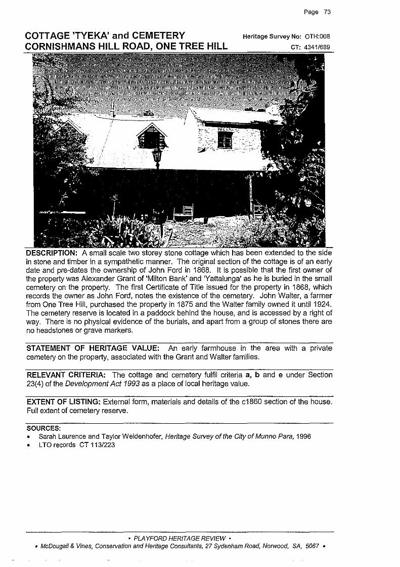
COTTAGE 'TYEKA' and CEMETERY CORNISHMANS HILL ROAD, ONE TREE HILL
Page 73
Heritage Survey No: OTH:OOB
CT: 4341/689
DESCRIPTION: A small scale two storey stone cottage which has been extended to the side in stone and timber in a sympathetic manner. The original section of the cottage is of an early date and pre-dates the ownership of John Ford in 1868. It is possible that the first owner of the property was Alexander Grant of 'Milton Bank' and 'Yattalunga' as he is buried in the small cemetery on the property. The first Certificate of Title issued for the property in 1868, which records the owner as John Ford, notes the existence of the cemetery. John Walter, a farmer from One Tree Hill, purchased the property in 1875 and the Walter family owned it until 1924. The cemetery reserve is located in a paddock behind the house, and is accessed by a right of way. There is no physical evidence of the burials, and apart from a group of stones there are no headstones or grave markers.
STATEMENT OF HERITAGE VALUE: An early farmhouse in the area with a private cemetery on the property, associated with the Grant and Walter families.
RELEVANT CRITERIA: The cottage and cemetery fulfil criteria a, b and e under Section 23(4) of the Development Act 1993 as a place of local heritage value.
EXTENT OF LISTING: External form, materials and details of the c1860 section of the house. Full extent of cemetery reserve.
SOURCES: • Sarah Laurence and Taylor Weidenhofer, Heritage Survey of the City of Munno Para, 1996 • L TO records CT 113/223
• PLAYFORD HERITAGE REVIEW • • McDougall & Vines, Conservation and Heritage Consultants, 27 Sydenham Road, Norwood, SA, 5067 •
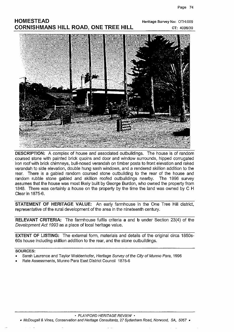
HOMESTEAD CORNISHMANS HILL ROAD, ONE TREE HILL
Page 74
Heritage Survey No: OTH:009
CT: 4096/39
DESCRIPTION: A complex of house and associated outbuildings. The house is of random coursed stone with painted brick quoins and door and window surrounds, hipped corrugated iron roof with brick chimneys, bull-nosed verandah on timber posts to front elevation and raked verandah to side elevation, double hung sash windows, and a rendered skillion addition to the rear. There is a gabled random coursed stone outbuilding to the rear of the house and random rubble stone gabled and skillion roofed outbuildings nearby. The 1996 survey assumes that the house was most likely built by George Burdon, who owned the property from 1848. There was certainly a house on the property by the time the land was owned by C H Clear in 1875-6.
STATEMENT OF HERITAGE VALUE: An early farmhouse in the One Tree Hill district, representative of the rural development of the area in the nineteenth century.
RELEVANT CRITERIA: The farmhouse fulfils criteria a and b under Section 23(4) of the Development Act 1993 as a place of local heritage value.
EXTENT OF LISTING: The external form, materials and details of the original circa 1850s-60s house including skillion addition to the rear, and the stone outbuildings.
SOURCES: • Sarah Laurence and Taylor Weidenhofer, Heritage Survey of the City of Munno Para, 1996 • Rate Assessments, Munno Para East District Council 1875-6
• PLAYFORD HERITAGE REVIEW • • McDougall & Vines, Conservation and Heritage Consultants, 27 Sydenham Road, Norwood, SA, 5067 •

HOUSE CROSSHILL ROAD, ONE TREE HILL
Page 75
Heritage Suovey No: OTH:010
CT: 4325/77
DESCRIPTION: A rendered stone house with hipped corrugated iron roof and verandah, as a continuation of the roof, on simple timber posts, brick chimney and double hung sash windows. The land on which this house stands was granted to Leonard !anson in 1851, and it was conveyed to Edward Walter in 1858 and he built the house some time before his death in 1870, as the house was part of his estate. The house has remained in the Walter family since.
STATEMENT OF HERITAGE VALUE: An early farmhouse in the One Tree Hill district, associated with the Walter family and representative of the rural development of the area.
RELEVANT CRITERIA: The house fulfils criteria a and b under Section 23(4) of the Development Act 1993 as a place of local heritage value.
EXTENT OF LISTING: The external form, materials and details of the original circa 1860s house including the verandah as an extension of the roof.
SOURCES: • Sarah Laurence and Taylor Weidenhofer, Heritage Survey of the City of Munno Para, 1996
• PLAYFORD HERITAGE REVIEW • • McDougall & Vines, Conservation and Heritage Consultants, 27 Sydenham Road, Norwood, SA, 5067 •

HOUSE 'CROSSHILL' CROSSHILL ROAD, ONE TREE HILL
Page 76
Heritage Survey No: OTH:011
CT: 2310/135
DESCRIPTION: A random coursed stone house with brick quoins and surrounds, hipped and gabled corrugated iron roof with brick chimneys, and half timbering to large gable to the front elevation. The gabled roof stone section to the rear of the house is a later addition. There is a recent bull-nosed return verandah on timber posts. Attached to the house is a random coursed stone barn with stone quoins, and adjacent is a partly underground stone walled tank, roofed with corrugated iron. The land on which this house stands was granted to Edward Cain in 1849, and it was sold to Edward Walter between 1858 and 1859. Walter died in 1871 and his will described a house and outbuildings on this land. The property was still owned by the Walter family at the time of the 1996 survey. The house has undergone some renovations over the years.
STATEMENT OF HERITAGE VALUE: An early farmhouse in the One Tree Hill area, representative of the rural development of the district. The property has belonged to members of the Walter family since the 1860s.
RELEVANT CRITERIA: The house fulfils criteria a, b and e under Section 23(4) of the Development Act 1993 as a place of local heritage value.
EXTENT OF LISTING: The external form, materials and details of the original circa 1860s house including the later stone section to the rear of the house and the associated outbuildings.
SOURCES: • Sarah Laurence and Taylor Weidenhofer, Heritage Survey of the City of Munno Para, 1996
• PLAYFORD HERITAGE REVIEW • • McDougall & Vines, Conservation and Heritage Consultants, 27 Sydenham Road, Norwood, SA, 5067 •
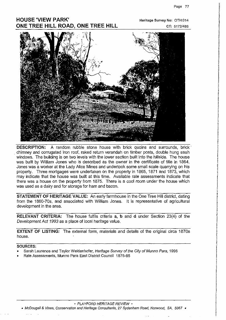
HOUSE 'VIEW PARK' ONE TREE HILL ROAD, ONE TREE HILL
Page 77
Heritage Survey No: OTH:014
CT: 5172/486
DESCRIPTION: A random rubble stone house with brick quoins and surrounds, brick· . chimney and corrugated iron roof, raked return verandah on timber posts, double hung sash windows. The building is on two levels with the lower section built into the hillside. The house was built by William Jones who is described as the owner in the certificate of title in 1864. Jones was a worker at the Lady Alice Mines and undertook some small scale quarrying on his property. Three mortgages were undertaken on the property in 1865, 1871 and 1873, which may indicate that the house was built at this time. Available rate assessments indicate that there was a house on the property from 1875. There is a cool roorn under the house which was used as a dairy and for storage for ham and bacon.
STATEMENT OF HERITAGE VALUE: An early farmhouse in the One Tree Hill district, dating from the 1860-70s, and associated with William Jones. It is representative of agricultural development in the area.
RELEVANT CRITERIA: The house fulfils criteria a, b and d under Section 23(4) of the Development Act 1993 as a place of local heritage value.
EXTENT OF LISTING: The external form, materials and details of the original circa 1870s house.
SOURCES: • Sarah Laurence and Taylor Weidenhofer, Heritage Survey of the City of Munno Para, 1996 • Rate Assessments, Munno Para East District Council 1875-85
• PLAYFORD HERITAGE REVIEW • • McDougall & Vines, Conservation and Heritage Consultants, 27 Sydenham Road, Norwood, SA, 5067 •
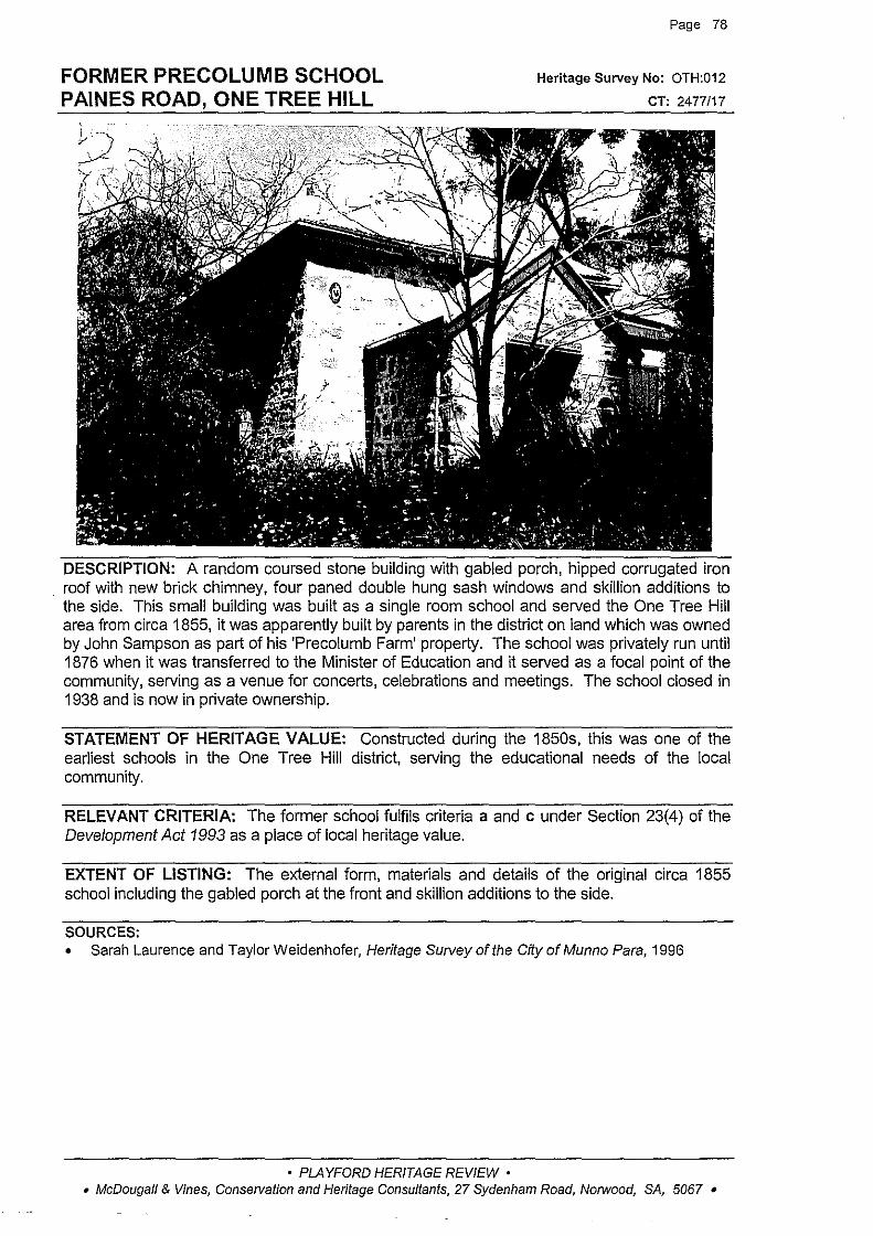
FORMER PRECOLUMB SCHOOL PAINES ROAD, ONE TREE HILL
Page 78
Heritage Survey No: OTH:012
CT: 2477/17
DESCRIPTION: A random coursed stone building with gabled porch, hipped corrugated iron . roof with new brick chimney, four paned double hung sash windows and skillion additions to
the side. This small building was built as a single room school and served the One Tree Hill area from circa 1855, it was apparently built by parents in the district on land which was owned by John Sampson as part of his 'Precolumb Farm' property. The school was privately run until 1876 when it was transferred to the Minister of Education and it served as a focal point of the community, serving as a venue for concerts, celebrations and meetings. The school closed in 1938 and is now in private ownership.
STATEMENT OF HERITAGE VALUE: Constructed during the 1850s, this was one of the earliest schools in the One Tree Hill district, serving the educational needs of the local community.
RELEVANT CRITERIA: The former school fulfils criteria a and c under Section 23(4) of the Development Act 1993 as a place of local heritage value.
EXTENT OF LISTING: The external form, materials and details of the original circa 1855 school including the gabled porch at the front and skillion additions to the side.
SOURCES: • Sarah Laurence and Taylor Weidenhofer, Heritage Survey of the City of Munno Para, 1996
• PLAYFORD HERITAGE REVIEW • • McDougall & Vines, Conservation and Heritage Consultants, 27 Sydenham Road, Norwood, SA, 5067 •
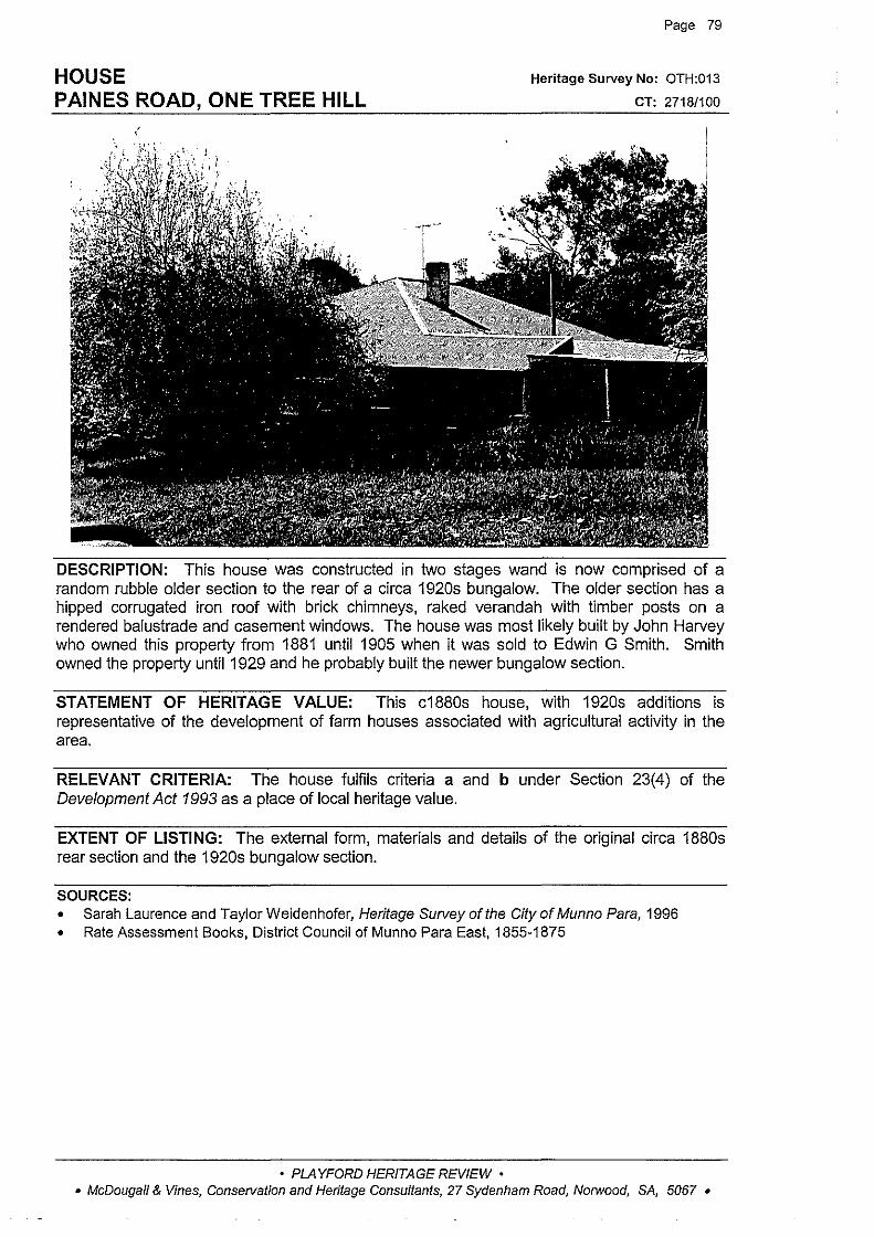
HOUSE PAINES ROAD, ONE TREE HILL
' '
Page 79
Heritage Survey No: OTH:013
CT: 2718/100
DESCRIPTION: This house was constructed in two stages wand is now comprised of a random rubble older section to the rear of a circa 1920s bungalow. The older section has a hipped corrugated iron roof with brick chimneys, raked verandah with timber posts on a rendered balustrade and casement windows. The house was most likely built by John Harvey who owned this property from 1881 until 1905 when it was sold to Edwin G Smith. Smith owned the property until 1929 and he probably built the newer bungalow section.
STATEMENT OF HERITAGE VALUE: This c1880s house, with 1920s additions is representative of the development of farm houses associated with agricultural activity in the area.
RELEVANT CRITERIA: The house fulfils criteria a and b under Section 23(4) of the Development Act 1993 as a place of local heritage value.
EXTENT OF LISTING: The external form, materials and details of the original circa 1880s rear section and the 1920s bungalow section.
SOURCES: • Sarah Laurence and Taylor Weidenhofer, Heritage Survey of the City of Munno Para, 1996 • Rate Assessment Books, District Council of Munno Para East, 1855-1875
• PLAYFORD HERITAGE REVIEW • • McDougall & Vines, Conservation and Heritage Consultants, 27 Sydenham Road, Norwood, SA, 5067 •
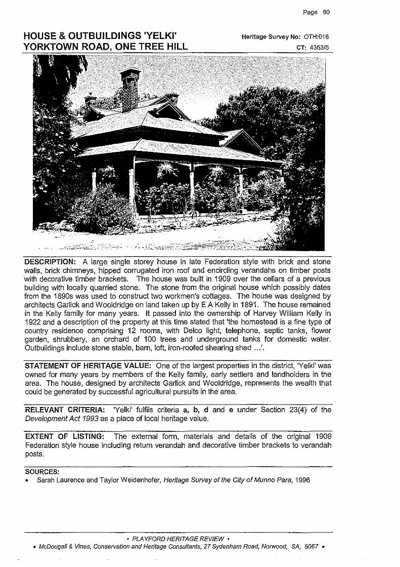
Page 80
HOUSE & OUTBUILDINGS 'YELKI' Heritage Survey No: OTH:016
YORKTOWN ONE TREE HILL
DESCRIPTION: A large single storey house in late Federation style with brick and stone walls, brick chimneys, hipped corrugated iron roof and encircling verandahs on timber posts ·with decorative timber brackets. The house was built in 1909 over the cellars of a previous building with locally quarried stone. The stone from the original house which possibly dates from the 1890s was used to construct two workmen's cottages. The house was designed by architects Garlick and Wooldridge on land taken up by E A Kelly in 1891. The house remained in the Kelly family for many years. It passed into the ownership of Harvey William Kelly in 1922 and a description of the property at this time stated that 'the homestead is a fine type of country residence comprising 12 rooms, with Delco light, telephone, septic tanks, flower garden, shrubbery, an orchard of 100 trees and underground tanks for domestic water. Outbuildings include stone stable, barn, loft, iron-roofed shearing shed .. .'.
STATEMENT OF HERITAGE VALUE: One of the largest properties in the district, 'Yelki' was owned for many years by members of the Kelly family, early settlers and landholders in the area. The house, designed by architects Garlick and Wooldridge, represents the wealth that could be generated by successful agricultural pursuits in the area.
RELEVANT CRITERIA: 'Yelki' fulfils criteria a, b, d and e under Section 23(4) of the Development Act 1993 as a place of local heritage value.
EXTENT OF LISTING: The external form, materials and details of the original 1909 Federation style house including return verandah and decorative timber brackets to verandah posts.
SOURCES: • Sarah Laurence and Taylor Weidenhofer, Heritage Survey of the City of Munno Para, 1996
• PLAYFORD HERITAGE REVIEW • • McDougall & Vines, Conservation and Heritage Consultants, 27 Sydenham Road, Norwood, SA, 5067 •
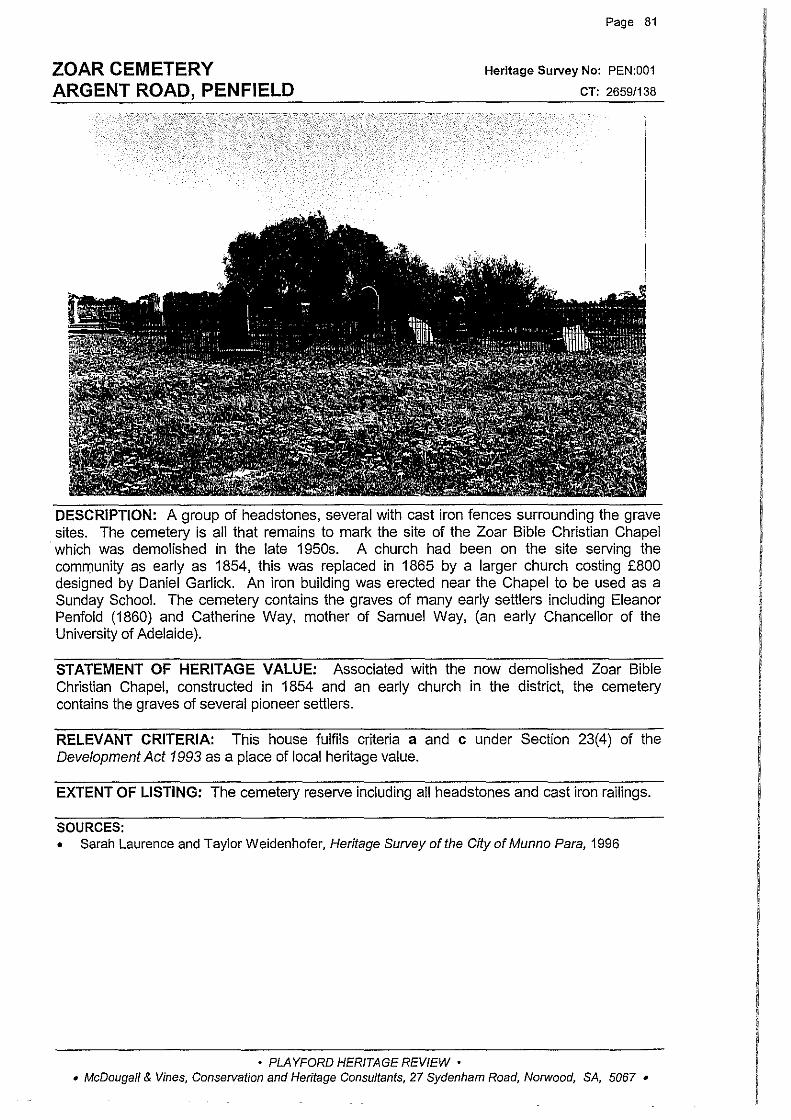
ZOAR CEMETERY ARGENT ROAD, PENFIELD
Page 81
Heritage Survey No: PEN:001
CT: 2659/138
DESCRIPTION: A group of headstones, several with cast iron fences surrounding the grave sites. The cemetery is all that remains to mark the site of the Zoar Bible Christian Chapel
·which was demolished in the late 1950s. A church had been on the site serving the community as early as 1854, this was replaced in 1865 by a larger church costing £800 designed by Daniel Garlick. An iron building was erected near the Chapel to be used as a Sunday School. The cemetery contains the graves of many early settlers including Eleanor Penfold (1860) and Catherine Way, mother of Samuel Way, (an early Chancellor of the University of Adelaide).
STATEMENT OF HERITAGE VALUE: Associated with the now demolished Zoar Bible Christian Chapel, constructed in 1854 and an early church in the district, the cemetery contains the graves of several pioneer settlers.
RELEVANT CRITERIA: This house fulfils criteria a and c under Section 23(4) of the Development Act 1993 as a place of local heritage value.
EXTENT OF LISTING: The cemetery reserve including all headstones and cast iron railings.
SOURCES: • Sarah Laurence and Taylor Weidenhofer, Heritage Survey of the City of Munno Para, 1996
• PLAYFORD HERITAGE REVIEW • • McDougall & Vines, Conservation and Heritage Consultants, 27 Sydenham Road, Norwood, SA, 5067 •

CARCLEW PRIMITIVE METHODIST CHURCH CARCLEW ROAD, PENFIELD GARDENS
Page 82
Heritage Survey No: PGN:001
CT: 3413/133
DESCRIPTION: A random coursed stone church with tuck pointed walls, dressed stone quoins and rendered surrounds, circular headed windows and a gabled roof clad with corrugated iron, a small belfry to gable end and circular opening. There are rendered remnants of a porch with 'Primitive Methodist erected AD 1870' engraved in the panel across the front. There is a small cemetery adjacent to the church which contains the graves of many early settlers in the area ..
This is the second Primitive Methodist Church to be built on the site. A brick building was erected in the early 1850s and served as the first Methodist Church on the Gawler Plains with the exception of the Wesleyan Methodist Church at Gawler. By the 1860s the original church was too small, and it was replaced in 1870 by the new stone building. Regular services at the Carclew Church ceased in 1919, although the Church and Cemetery were kept in good condition by the Trustees. The District Council of Munno Para took over ownership of the church and cemetery in 1965 and the building is currently in a dilapidated condition.
• PLAYFORD HERITAGE REVIEW • • McDougall & Vines, Conservation and Heritage Consultants, 27 Sydenham Road, Norwood, SA, 5067 •

CARCLEW PRIMITIVE METHODIST CHURCH CARCLEW ROAD, PENFIELD GARDENS (cont)
Page 83
STATEMENT OF HERITAGE VALUE: An early church and cemetery on the Gawler Plains, reflecting the pattern of settlement to the north of Adelaide in the mid 1800s and the provision of religious venues for the local community. The landmark church building was erected with the help of the pioneering settlers in the district.
RELEVANT CRITERIA: This former church, and associated cemetery, fulfils criteria a and c under Section 23(4) of the Development Act 1993 as a place of local heritage value.
EXTENT OF LISTING: The external form, materials and detailing of the original1870 church, including gabled roof and small pedimented entrance porch, and the adjacent cemetery reserve.
Note: This building requires urgent stabilisation work.
SOURCES: • Sarah Laurence and Taylor Weidenhofer, Heritage Survey of the City of Munno Para, 1996
View of the cemetery from the Church
• PLAYFORD HERITAGE REVIEW • • McDougall & Vines, Conservation and Heritage Consultants, 27 Sydenham Road, Norwood, SA, 5067 •
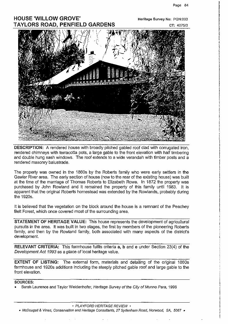
HOUSE 'WILLOW GROVE' TAYLORS ROAD, PENFIELD GARDENS
Page 84
Heritage Survey No: PGN:003
CT: 4075/3
DESCRIPTION: A rendered house with broadly pitched gabled roof clad with corrugated iron, rendered chimneys with terracotta pots, a large gable to the front elevation with half timbering and double hung sash windows. The roof extends to a wide verandah with timber posts and a rendered masonry balustrade.
The property was owned in the 1860s by the Roberts family who were early settlers in the Gawler River area. The early section of house (now to the rear of the existing house) was built at the time of the marriage of Thomas Roberts to Elizabeth Rowe. In 1872 the property was purchased by John Rowland and it remained the property of this family until 1983. It is apparent that the original Roberts homestead was extended by the Rowlands, probably during the 1920s.
It is believed that the vegetation on the block around the house is a remnant of the Peachey Belt Forest, which once covered most of the surrounding area.
STATEMENT OF HERITAGE VALUE: This house represents the development of agricultural pursuits in the area. It was built in two stages, the first by members of the pioneering Roberts family, and then by the Rowland family, both associated with many aspects of the district's development.
RELEVANT CRITERIA: This farmhouse fulfils criteria a, band e under Section 23(4) of the Development Act 1993 as a place of local heritage value.
EXTENT OF LISTING: The external form, materials and detailing of the original 1860s farmhouse and 1920s additions including the steeply pitched gable roof and large gable to the front elevation.
SOURCES: • Sarah Laurence and Taylor Weidenhofer, Heritage Survey of the City of Munno Para, 1996
• PLAYFORD HERITAGE REVIEW • • McDougall & Vines, Conservation and Heritage Consultants, 27 Sydenham Road, NoTWood, SA, 5067 •

FARMHOUSE WINIFRED ROAD, PENFIELD GARDENS
Page 85
Heritage Survey No: PGN:002
CT: 3922/17
DESCRIPTION: A farmhouse with random coursed stone walls, brick quoins and surrounds, hipped corrugated iron roof and double hung sash windows. The previous survey noted the building had a bull-nose return verandah, which is now missing. The building is in a dilapidated condition.
This land was originally granted to Thomas Butcher in 1848. Butcher was still the owner in 1875 and the first reference in the rate assessments to a house on this property was in 1871. The property on which the house stands was subdivided some time after 1961.
STATEMENT OF HERITAGE VALUE: An 1871 farmhouse on the Gawler River, representing the rural development of the plains north of Adelaide.
RELEVANT CRITERIA: This house fulfils criteria a and b under Section 23(4) of the Development Act 1993 as a place of local heritage value.
EXTENT OF LISTING: The external form, materials and detailing of the original 1871 farmhouse, (now missing its return verandah).
SOURCES: • Sarah Laurence and TaylorWeidenhofer, Heritage Surveyofthe CityofMunno Para, 1996 • Rate Assessment Books, District Council of Munno Para West, 1855-1875
• PLAYFORD HERITAGE REVIEW • • McDougall & Vines, Conservation and Heritage Consultants, 27 Sydenham Road, Norwood, SA, 5067 •
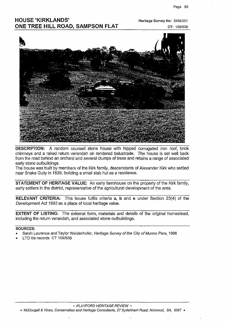
HOUSE 'KIRKLANDS' ONE TREE HILL ROAD, SAMPSON FLAT
Page 86
Heritage Survey No: SAM:001
CT: 109/539
DESCRIPTION: A random coursed stone house with hipped corrugated iron roof, brick chimneys and a raked return verandah on rendered balustrade. The house is set well back from the road behind an orchard and several clumps of trees and retains a range of associated early stone outbuildings. The house was built by members of the Kirk family, descendants of Alexander Kirk who settled near Snake Gully in 1839, building a small slab hut as a residence.
STATEMENT OF HERITAGE VALUE: An early farmhouse on the property of the Kirk family, early settlers in the district, representative of the agricultural development of the area.
RELEVANT CRITERIA: This house fulfils criteria a, b and e under Section 23(4) of the Development Act 1993 as a place of local heritage value.
EXTENT OF LISTING: The external form, materials and details of the original homestead, including the return verandah, and associated stone outbuildings.
SOURCES: • Sarah Laurence and Taylor Weidenhofer, Heritage Survey of the City of Munno Para, 1996 • L TO tile records CT 1 09/539
• PLAYFORD HERITAGE REVIEW • • McDougall & Vines, Conservation and Heritage Consultants, 27 Sydenham Road, Norwood, SA, 5067 •
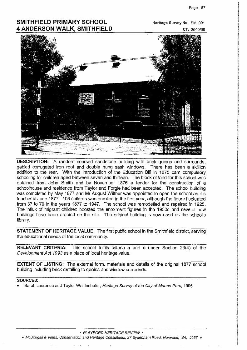
SMITHFIELD PRIMARY SCHOOL 4 ANDERSON WALK, SMITHFIELD
Page 87
Heritage Survey No: SMI:001
CT: 3540/68
DESCRIPTION: A random coursed sandstone building with brick quoins and surrounds, gabled corrugated iron roof and double hung sash windows. There has been a skillion addition to the rear. With the introduction of the Education Bill in 1875 cam compulsory schooling for children aged between seven and thirteen. The block of land for this school was obtained from John Smith and by November 1876 a tender for the construction of a schoolhouse and residence from Taylor and Forgie had been accepted. The school building was completed by May 1877 and Mr August Wittber was appointed to open the school as it s teacher in June 1877. 108 children was enrolled in the first year, although the figure fluctuated from 37 to 70 in the years 1877 to 1947. The school was remodelled and repaired in 1925. The influx of migrant children boosted the enrolment figures in the 1950s and several new buildings have been erected on the site. The original building is now used as the school's library.
STATEMENT OF HERITAGE VALUE: The first public school in the Smithfield district, serving the educational needs of the local community.
RELEVANT CRITERIA: This school fulfils criteria a and c under Section 23(4) of the Development Act 1993 as a place of local heritage value.
EXTENT OF LISTING: The external form, materials and details of the original 1877 school building including brick detailing to quoins and window surrounds.
SOURCES: • Sarah Laurence and Taylor Weidenhofer, Heritage Survey of the City of Munno Para, 1996
• PLAYFORD HERITAGE REVIEW • • McDougall & Vines, Conservation and Heritage Consultants, 27 Sydenham Road, Norwood, SA, 5067 •
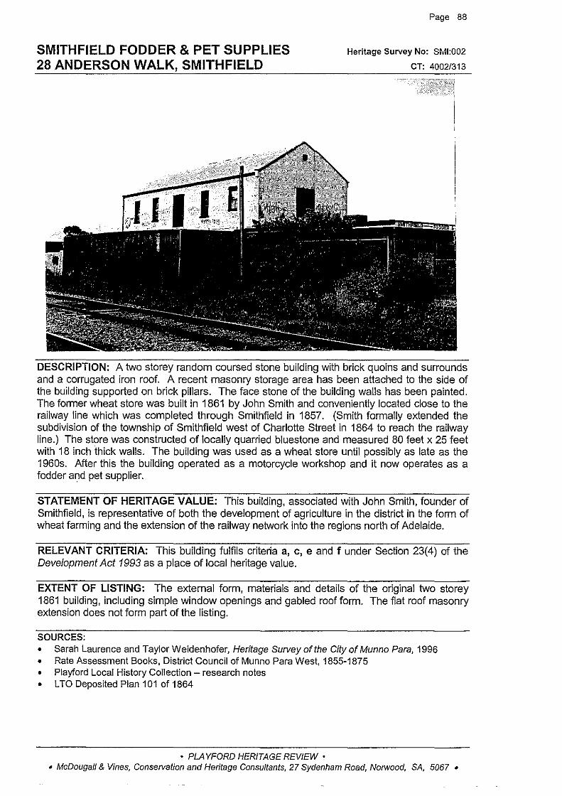
SMITHFIELD FODDER & PET SUPPLIES 28 ANDERSON WALK, SMITHFIELD
Page 88
Heritage Survey No: SMI:002
CT: 4002/313
DESCRIPTION: A two storey random coursed stone building with brick quoins and surrounds and a corrugated iron roof. A recent masonry storage area has been attached to the side of the building supported on brick pillars. The face stone of the building walls has been painted. The former wheat store was built in 1861 by John Smith and conveniently located close to the railway line which was completed through Smithfield in 1857. (Smith formally extended the subdivision of the township of Smithfield west of Charlotte Street in 1864 to reach the railway line.) The store was constructed of locally quarried bluestone and measured 80 feet x 25 feet with 18 inch thick walls. The building was used as a wheat store until possibly as late as the 1960s. After this the building operated as a motorcycle workshop and it now operates as a fodder and pet supplier.
STATEMENT OF HERITAGE VALUE: This building, associated with John Smith, founder of Smithfield, is representative of both the development of agriculture in the district in the form of wheat farming and the extension of the railway network into the regions north of Adelaide.
RELEVANT CRITERIA: This building fulfils criteria a, c, e and f under Section 23(4) of the Development Act 1993 as a place of local heritage value.
EXTENT OF LISTING: The external form, materials and details of the original two storey 1861 building, including simple window openings and gabled roof form. The fiat roof masonry extension does not form part of the listing.
SOURCES: • Sarah Laurence and TaylorWeidenhofer, Heritage Surveyofthe CityofMunno Para, 1996 • Rate Assessment Books, District Council of Munno Para West, 1855-1875 • Playford Local History Collection - research notes • L TO Deposited Plan 101 of 1864
• PLAYFORD HERITAGE REVIEW • • McDougall & Vines, Conservation and Heritage Consultants, 27 Sydenham Road, Norwood, SA, 5067 •

HOUSE 38 ANDERSON WALK, SMITHFIELD
Page 89
Heritage Survey No: SMI:003
CT: 181/203, 2814/132
DESCRIPTION: A random coursed sandstone house with brick quoins and surrounds, a hipped roof with gable! clad with concrete tiles, rendered chimneys, bull-nose verandah on simple timber posts with simple brackets and double hung sash windows. This house was most likely built by Michael McGee, a railway packer, in 1926 with finance from the State Bank. Rate assessments indicate vacant land in 1925.
STATEMENT OF HERITAGE VALUE: One of the later houses to be built in the township of Smithfield, built in the mid 1920s. It is representative of post-WW1 development in Smithfield and reflects the increase in population and prosperity to the town brought about by the railway.
RELEVANT CRITERIA: This house fulfils criteria a, b and e under Section 23(4) of the Development Act 1993 as a place of local heritage value.
EXTENT OF LISTING: The external form, materials and details of the original 1920s house including bull-nose verandah on timber posts. The roof tiles are not original and do not form part of the listing.
SOURCES: • Sarah Laurence and Taylor Weidenhofer, Heritage Survey of the City of Munno Para, 1996 • Rate Assessments, Munno Para West District Council
• PLAYFORD HERITAGE REVIEW • • McDougall & Vines, Conservation and Heritage Consultants, 27 Sydenham Road, N01wood, SA, 5067 •

HOUSE 44 ANDERSON WALK, SMITHFIELD
Page 90
Heritage Survey No: SM\:004
CT: 2146177
DESCRIPTION: A random coursed stone house with brick quoins and surrounds and string course, hipped corrugated iron roof with gable! and brick chimneys, bull-nose verandah on simple timber posts and double hung sash windows. The house is built on land which was originally part of a property owned by Samuel Crettenden. In 1883 this property was sold to Samuel Dawkins, John Martin and Charles Annels and then re-sold in 1894 to James Barshott. In 1926 the land was still vacant and owned by George McGee, and the house was built by him in 1927.
STATEMENT OF HERITAGE VALUE: This house, built in the mid 1920s, is one of the later houses to be built in the township of Smithfield. It is representative of post-WW1 development in Smithfield and reflects the increase in population and prosperity to the town brought about by the railway.
RELEVANT CRITERIA: This house fulfils criteria a, b and e under Section 23(4) of the Development Act 1993 as a place of local heritage value.
EXTENT OF LISTING: The external form, materials and details of the original c1890s house including bull-nose verandah on timber posts.
SOURCES: • Sarah Laurence and TaylorWeidenhofer, Heritage Surveyofthe CityofMunno Para, 1996 • Rate Assessments, Munno Para West District Council
• PLAYFORD HERITAGE REVIEW • • McDougall & Vines, Conservation and Hen"fage Consultants, 27 Sydenham Road, Norwood, SA, 5067 •
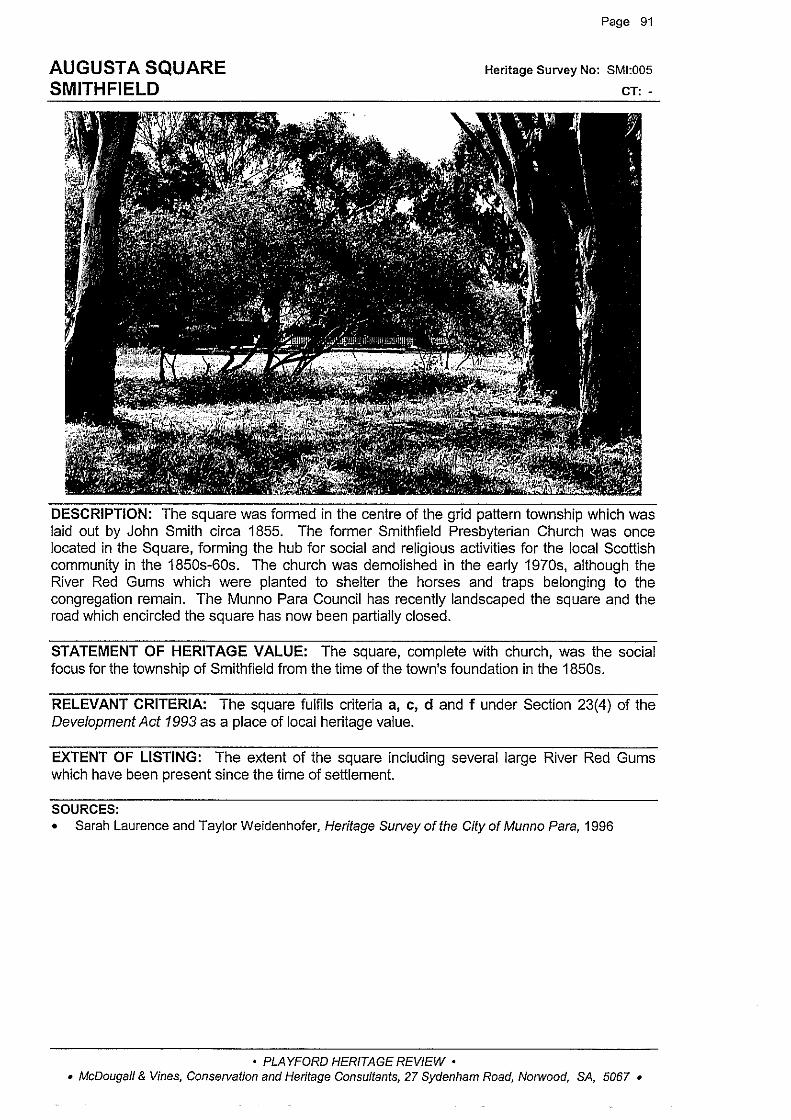
AUGUST A SQUARE SMITHFIELD
Page 91
Heritage Survey No: SMI:005
CT: -
DESCRIPTION: The square was formed in the centre of the grid pattern township which was laid out by John Smith circa 1855. The former Smithfield Presbyterian Church was once located in the Square, forming the hub for social and religious activities for the local Scottish community in the 1850s-60s. The church was demolished in the early 1970s, although the River Red Gums which were planted to shelter the horses and traps belonging to the congregation remain. The Munno Para Council has recently landscaped the square and the road which encircled the square has now been partially closed.
STATEMENT OF HERITAGE VALUE: The square, complete with church, was the social focus for the township of Smithfield from the time of the town's foundation in the 1850s.
RELEVANT CRITERIA: The square fulfils criteria a, c, d and f under Section 23(4) of the Development Act 1993 as a place of local heritage value.
EXTENT OF LISTING: The extent of the square including several large River Red Gums which have been present since the time of settlement.
SOURCES: • Sarah Laurence and Taylor Weidenhofer, Heritage Survey of the City of Munno Para, 1996
• PLAYFORD HERITAGE REVIEW • • McDougall & Vines, Conse!Vation and Heritage Consultants, 27 Sydenham Road, Notwood, SA, 5067 •

COTTAGE 5 GARDINER TERRACE, SMITHFIELD
Page 92
Heritage Survey No: SMI:006
CT: 4057/834
DESCRIPTION: A random rubble stone cottage with brick quoins and surrounds, hipped corrugated iron roof (shallow pitch) with brick chimneys and double hung sash windows. the raked return verandah is an extension of the roof on turned timber posts. There is a skillion addition to the rear. This cottage is reputed to be one of the oldest in Smithfield, serving as the first Inn in the district, before John Smith arrived in the area. The earliest records for the house date from 1883 when the property was owned by William Owen, a 'gentleman' of Smithfield. The style of the dwelling indicates that it was built well before this date, possibly as early as the 1850s.
STATEMENT OF HERITAGE VALUE: An early building in the 1850s village of Smithfield, and at one stage reputedly used as an inn, and representative of early settlement in the district. Owners or occupiers have included members of the Blake and Frisby families, both notable names in the district.
RELEVANT CRITERIA: This cottage fulfils criteria a, c and e under Section 23(4) of the Development Act 1993 as a place of local heritage value.
EXTENT OF LISTING: The external form, materials and details of the original circa 1850s cottage including shallow pitched roof with verandah incorporated into the roof, brick chimneys and skillion addition.
SOURCES: • Sarah Laurence and TaylorWeidenhofer, Heritage Sutveyofthe CityofMunno Para, 1996
• PLAYFORD HERITAGE REVIEW • • McDougall & Vines, Conservation and Heritage Consultants, 27 Sydenham Road, Norwood, SA, 5067 •

SMITHFIELD RAILWAY COTTAGES 142-145 GRAEBER ROAD, SMITHFIELD
Page 93
Heritage Survey No: SMI:007
CT: 4289/965-969
DESCRIPTION: Two pairs of attached cottages. The walls are rough cast rendered concrete with smooth rendered quoins and window and door surrounds. They have hipped corrugated iron roofs and verandahs, extensions of the roof line, supported on simple timber posts. The cottages have double hung sash windows and brick chimneys.
The railway line to Smithfield opened in June 1857, with a station building and original cottages (circa 1860s), providing the incentive for the commercial and residential development of Smithfield. The station operated 24 hours a day in the early years of the twentieth century and the cottages were provided as necessary accommodation for the workers. These cottages were built circa 1910 and replaced the original group of cottages built at the Smithfield Railway Station to house workers at the station. They are typical of railway cottages of that period, with walls constructed of reinforced concrete.
STATEMENT OF HERITAGE VALUE: The second group of railway cottages to be built at Smithfield, these are the only remaining structures of the earlier railway station buildings, reflecting the development of transport in the areas to the north of Adelaide.
RELEVANT CRITERIA: These cottages fulfil criteria a and d under Section 23(4) of the Development Act 1993 as a place of local heritage value.
EXTENT OF LISTING: The original external forrn, materials and simple details of the two pairs of circa 1910 attached cottages including roof pitch and simple detailing.
SOURCES: • Sarah Laurence and Taylor Weidenhofer, Heritage Survey of the City of Munno Para, 1996
• PLAYFORD HERITAGE REVIEW • • McDougall & Vines, Conservation and Heritage Consultants, 27 Sydenham Road, N01wood, SA, 5067 •

COTTAGE 5 HOPE STREET, SMITHFIELD
Page 94
Heritage Survey No: SMI:008
CT: 2399/176
DESCRIPTION: A random coursed stone cottage with brick quoins and surrounds, gabled corrugated iron roof and brick chimneys, concave verandah on simple timber posts and double hung sash split paned windows. There are skillion additions to the rear, the most recent being constructed of blockwork. The style of the building indicates it was built in the 1870s or 1880s. In 1893 the cottage was owned by William Smith, who sold it to Mary Huxtable in 1894. It was still owned by Henry Huxtable in 1911
STATEMENT OF HERITAGE VALUE: An early cottage in Smithfield, representative of the residential development of the township subdivided in the 1850s.
RELEVANT CRITERIA: This cottage fulfils criteria a and b under Section 23(4) of the Development Act 1993 as a place of local heritage value.
EXTENT OF LISTING: The external form, materials and details of the original 1870s-80s cottage, including the earlier of the two skillion additions to the rear and the simple form of the concave verandah with timber posts.
SOURCES: • Sarah Laurence and Taylor Weidenhofer, Heritage Survey of the City of Munno Para, 1996
• PLAYFORD HERITAGE REVIEW • • McDougall & Vines, Conservation and Heritage Consultants, 27 Sydenham Road, Norwood, SA, 5067 •

COTTAGE 24 JANE STREET, SMITHFIELD
Page 95
Heritage Survey No: SMI:009
CT: 5181/903
DESCRIPTION: A small random coursed stone single fronted cottage with brick quoins and surrounds, gabled corrugated iron roof and multi-paned casement windows. The cottage may have been built as a simple single roomed residence. The cottage was built pre 1865 when it was owned by Robert Oliver, a blacksmith. It was then owned by Alfred Blackman, a railway labourer.
STATEMENT OF HERITAGE VALUE: An early cottage in Smithfield, owned by a variety of railway workers and labourers, representing the development of the township as both a railway and rural centre.
RELEVANT CRITERIA: This house fulfils criteria a, b and e under Section 23(4) of the Development Act 1993 as a place of local heritage value.
EXTENT OF LISTING: The external form, materials and details of the original c1860 cottage including brick detailing to quoins and window surrounds.
SOURCES: • Sarah Laurence and Taylor Weidenhofer, Heritage Survey of the City of Munno Para, 1996
• PLAYFORD HERITAGE REVIEW • • McDougall & Vines, Conservation and Heritage Consultants, 27 Sydenham Road, Norwood, SA, 5067 •

SMITHFIELD HOTEL 1 MAIN NORTH ROAD, SMITHFIELD
Page 96
Heritage Survey No: SMI:01 0
CT: 4221/882
DESCRIPTION: A two storey building of random coursed stone, line pointed, with rendered quoins and window and door surrounds, hipped roof clad with slate, rendered chimneys, and multi-pane double hung sash windows. The building retains evidence of its early date in the remnant lined tuck-pointing between the stone courses. The original stonework is not now visible because of many layers of paint, but the building retains much early detailing. There are recent single storey extensions encircling the building including a drive through bottle-shop along the front elevation.
The hotel was built by John Smith in 1857 to replace the first hotel in the district known as the Wheatsheaf (also built by John Smith). The new two storey hotel was originally named 'The Railway Terminus' in acknowledgment of the arrival of the railway line to Smithfield in that year. It was then known as 'Smiths' and in the early days it was considered too large and grand by local residents who called it 'Smith's Folly'. The hotel operated as a mail stop and staging point along the Main North Road for all horse drawn transport, and continued to serve motor traffic in the later years as the only hotel between Salisbury and Gawler until the establishment of Elizabeth.
STATEMENT OF HERITAGE VALUE: The earliest remaining hotel in the Smithfield area, built by the founder of the town, John Smith, in anticipation of the increased patronage provided by the extension of the railway line to Smithfield in 1857. The two storey building, the largest in the nearby area, was located prominently on the Main North Road to attract passing trade.
RELEVANT CRITERIA: This hotel fulfils criteria a, b, c, e and f under Section 23(4) of the Development Act 1993 as a place of local heritage value.
EXTENT OF LISTING: The external form, materials and details of the original two storey 1850s hotel including hipped roof and rendered chimneys. The later single storey extensions including the drive through bottle-shop and restaurant sections do not form part of the listing.
• PLAYFORD HERITAGE REVIEW • • McDougall & Vines, Conservation and Heritage Consultants, 27 Sydenham Road, Norwood, SA, 5067 •
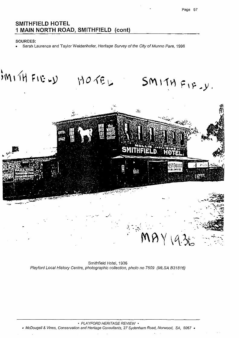
Page 97
SMITHFIELD HOTEL 1 MAIN NORTH ROAD, SMITHFIELD (cont)
SOURCES: • Sarah Laurence and Taylor Weidenhofer, Heritage Survey of the City of Munno Para, 1996
.·
Smithfield Hotel, 1936 Playford Local History Centre, photographic collection, photo no 7509 (MLSA 831816)
• PLAYFORD HERITAGE REVIEW • • McDougall & Vines, Conservation and Heritage Consultants, 27 Sydenham Road, Norwood, SA, 5067 •
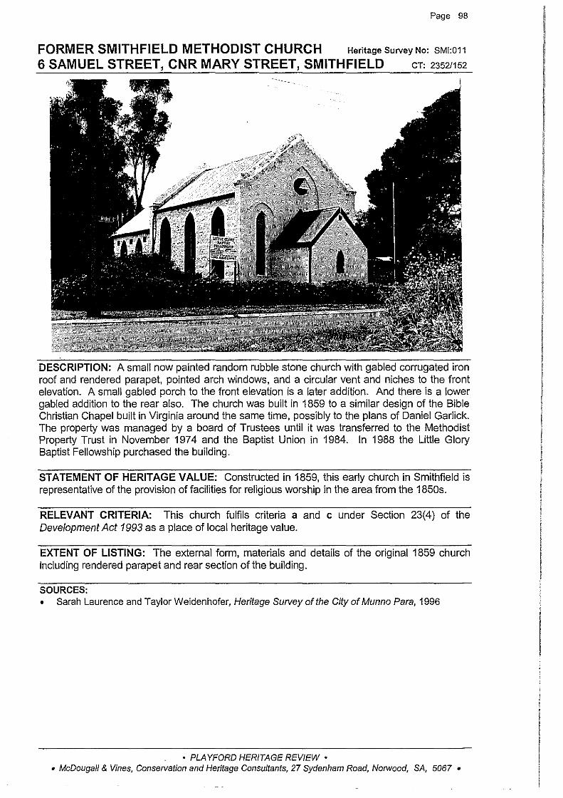
Page 98
FORMER SMITHFIELD METHODIST CHURCH Heritage Survey No: SMI:011
6 SAMUEL STREET, CNR MARY STREET, SMITHFIELD cr: 23521152
DESCRIPTION: A small now painted random rubble stone church with gabled corrugated iron roof and rendered parapet, pointed arch windows, and a circular vent and niches to the front elevation. A small gabled porch to the front elevation is a later addition. And there is a lower gabled addition to the rear also. The church was built in 1859 to a similar design of the Bible Christian Chapel built in Virginia around the same time, possibly to the plans of Daniel Garlick. The property was managed by a board of Trustees until it was transferred to the Methodist Property Trust in November 197 4 and the Baptist Union in 1984. In 1988 the Little Glory Baptist Fellowship purchased the building.
STATEMENT OF HERITAGE VALUE: Constructed in 1859, this early church in Smithfield is representative of the provision of facilities for religious worship in the area from the 1850s.
RELEVANT CRITERIA: This church fulfils criteria a and c under Section 23(4) of the Development Act 1993 as a place of local heritage value.
EXTENT OF LISTING: The external form, materials and details of the original 1859 church including rendered parapet and rear section of the building.
SOURCES: • Sarah Laurence and Taylor Weidenhofer, Heritage Survey of the City of Munno Para, 1996
• PLAYFORD HERITAGE REVIEW • • McDougall & Vines, Conservation and Heritage Consultants, 27 Sydenham Road, Norwood, SA, 5067 •

Page 99
COTTAGE Heritage Survey No: SMI:012
25 QUEEN STREET, CNR JANE STREET, SMITHFIELD cT: 43361105
DESCRIPTION: A rendered cottage with gabled corrugated iron roof, rendered chimney, raked verandah on simple timber posts and casement windows. There is a skillion addition to the rear. A later carport has been attached to the south side of the house. It is likely that this cottage was built in the late 1850s or early 1860s. The earliest available title (1892) for the land was in the name of George Beaumont (Jnr), a railway ganger, and this is confirmed by rate assessments which list Beaumont from 1880 onwards as the owner of the house. The house was then owned by a succession of railway workers.
STATEMENT OF HERITAGE VALUE: An early c1860s cottage in Smithfield, representative of the residential development of the township.
RELEVANT CRITERIA: This cottage fulfils criteria a, b and d under Section 23(4) of the Development Act 1993 as a place of local heritage value.
EXTENT OF LISTING: The external form, materials and details of the original 1850s-60s cottage including simple raked verandah on timber posts. The carport to the side of the building is not included in the listing.
SOURCES: • Sarah Laurence and Taylor Weidenhofer, Heritage Survey of the City of Munno Para, 1996 • L TO title records • Rate Assessments, Munno Para West District Council
• PLAYFORD HERITAGE REVIEW • • McDougall & Vines, Conservation and Heritage Consultants, 27 Sydenham Road, Norwood, SA, 5067 •
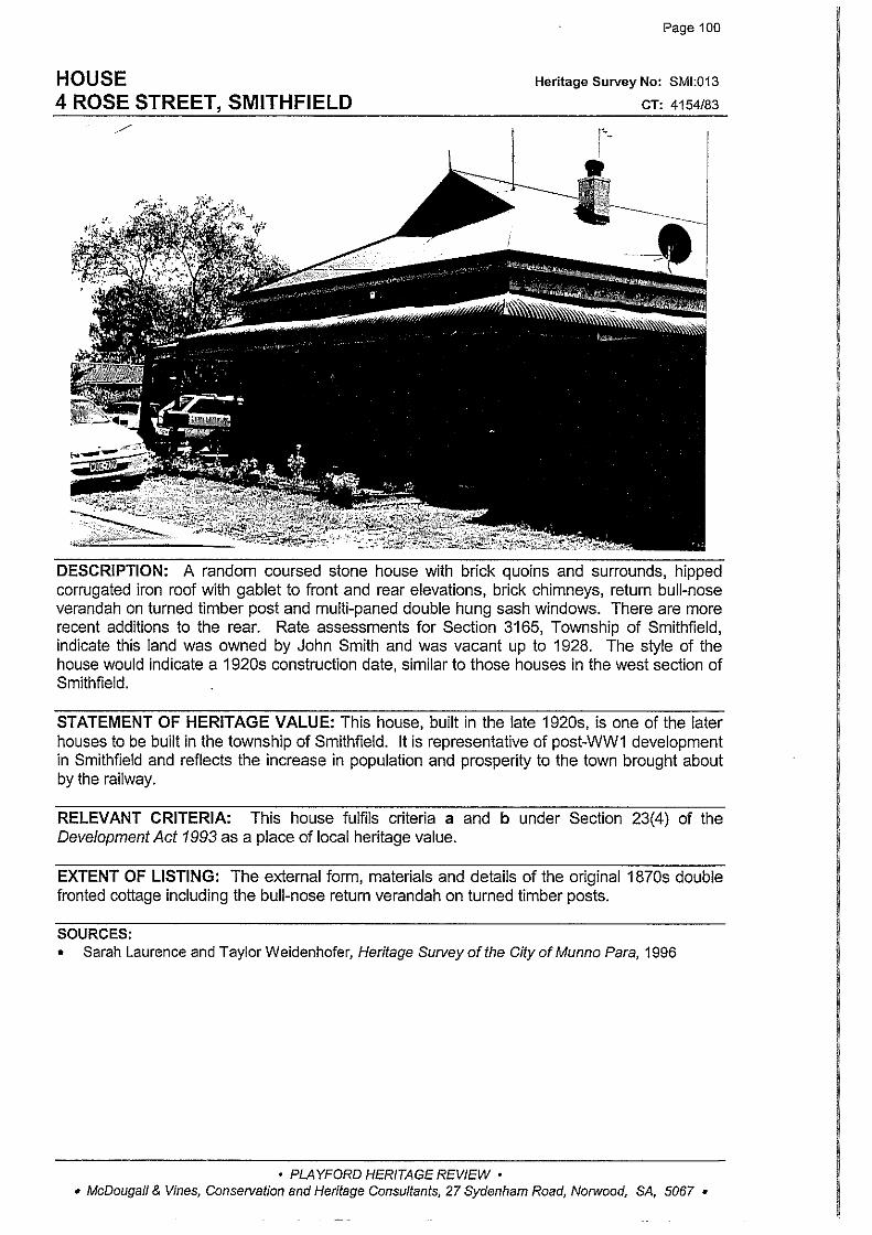
HOUSE 4 ROSE STREET, SMITHFIELD
Page 100
Heritage Survey No: SMI:013
CT: 4154/83
DESCRIPTION: A random coursed stone house with brick quoins and surrounds, hipped corrugated iron roof with gable! to front and rear elevations, brick chimneys, return bull-nose verandah on turned timber post and multi-paned double hung sash windows. There are more recent additions to the rear. Rate assessments for Section 3165, Township of Smithfield, indicate this land was owned by John Smith and was vacant up to 1928. The style of the house would indicate a 1920s construction date, similar to those houses in the west section of Smithfield.
STATEMENT OF HERITAGE VALUE: This house, built in the late 1920s, is one of the later houses to be built in the township of Smithfield. It is representative of post-WW1 development in Smithfield and reflects the increase in population and prosperity to the town brought about by the railway.
RELEVANT CRITERIA: This house fulfils criteria a and b under Section 23(4) of the Development Act 1993 as a place of local heritage value.
EXTENT OF LISTING: The external form, materials and details of the original 1870s double fronted cottage including the bull-nose return verandah on turned timber posts.
SOURCES: • Sarah Laurence and Taylor Weidenhofer, Heritage Survey of the City of Munno Para, 1996
• PLAYFORD HERITAGE REVIEW • • McDougall & Vines, Conservation and Heritage Consultants, 27 Sydenham Road, Norwood, SA, 5067 •
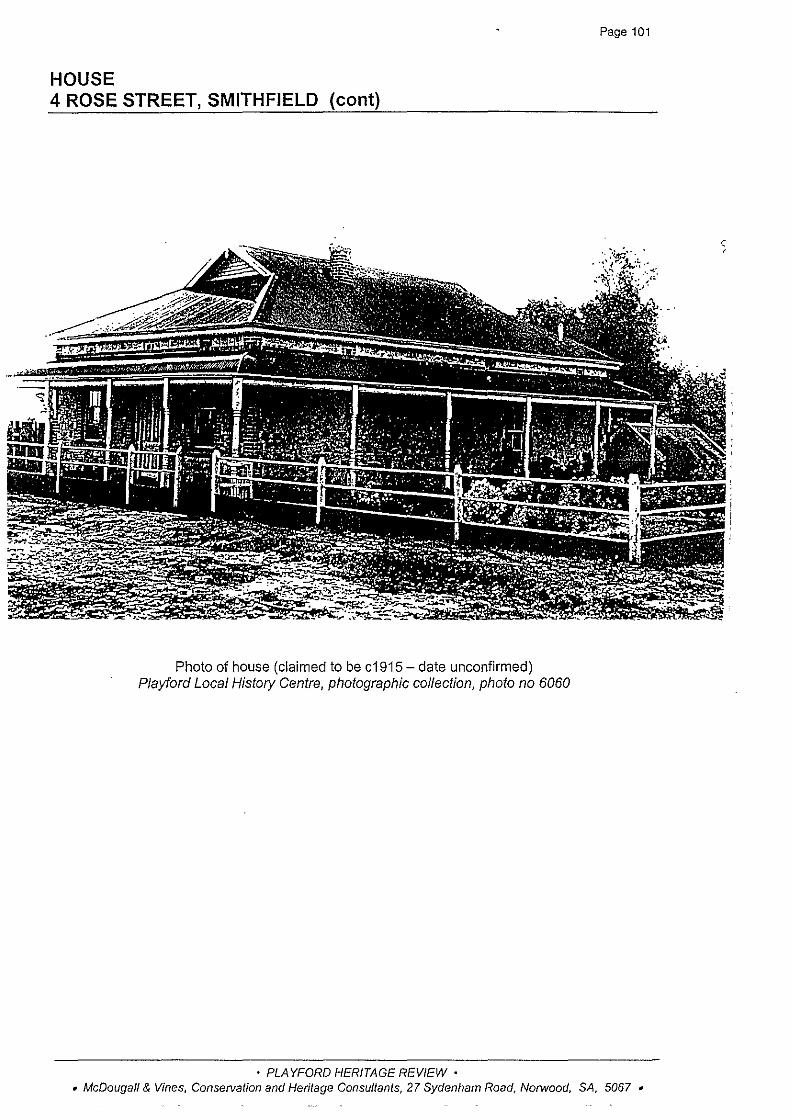
HOUSE 4 ROSE STREET, SMITHFIELD (cont)
Photo of house (claimed to be c1915- date unconfirmed) Playford Local History Centre, photographic collection, photo no 6060
• PLAYFORD HERITAGE REVIEW •
Page 101
• McDougall & Vines, Conservation and Heritage Consultants, 27 Sydenham Road, Norwood, SA, 5067 •
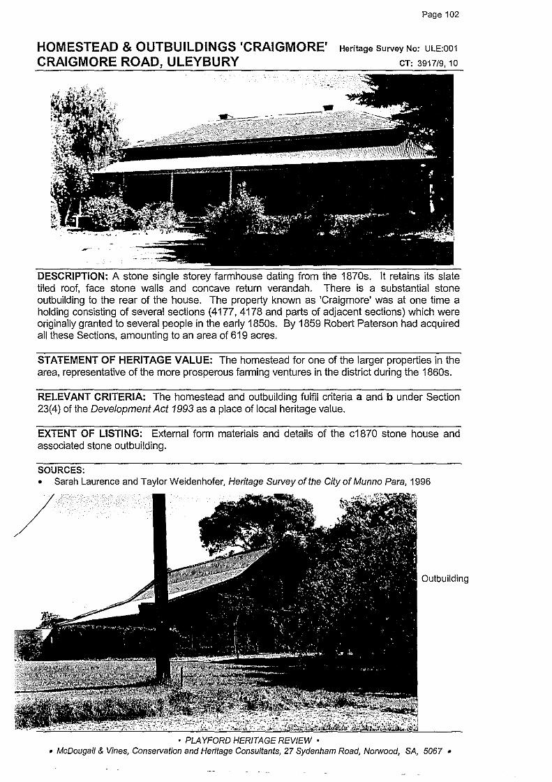
HOMESTEAD & OUTBUILDINGS 'CRAIGMORE' CRAIGMORE ROAD, ULEYBURY
·-
Page 102
Heritage Survey No: ULE:001
CT: 3917/9, 10
DESCRIPTION: A stone single storey farmhouse dating from the 1870s. It retains its slate tiled roof, face stone walls and concave return verandah. There is a substantial stone outbuilding to the rear of the house. The property known as 'Craigmore' was at one time a holding consisting of several sections (4177, 4178 and parts of adjacent sections) which were originally granted to several people in the early 1850s. By 1859 Robert Paterson had acquired all these Sections, amounting to an area of 619 acres.
STATEMENT OF HERITAGE VALUE: The homestead for one of the larger properties in the area, representative of the more prosperous farming ventures in the district during the 1860s.
RELEVANT CRITERIA: The homestead and outbuilding fulfil criteria a and b under Section 23(4) of the Development Act 1993 as a place of local heritage value.
EXTENT OF LISTING: External form materials and details of the c1870 stone house and associated stone outbuilding.
SOURCES: • Sarah Laurence and Taylor Weidenhofer, Heritage Survey of the City of Munno Para, 1996
Outbuilding
• PLAYFORD HERITAGE REVIEW • • McDougall & Vines, Conservation and Heritage Consultants, 27 Sydenham Road, Norwood, SA, 5067 •

Page 103
HOUSE, STABLES/BARN, SHEARING SHED & SHEEP DIP (FORMER 'YATTALUNGA' OUTBUILDINGS) MEDLOW ROAD, ULEYBURY
Heritage Survey No: ULE:002
CT: 5227/62, 5210/753
DESCRIPTION: These buildings are associated with 'Yattalunga' which is listed on the State Heritage Register. They were once the working buildings for that property established by Philip Butler in c1850. The property was sold to Joseph Barritt in 1878 and it remained in Barritt family ownership as a pastoral property until the mid 1950s when it was subdivided and sold.
House: painted random coursed stone house with brick quoins and surrounds, hipped corrugated iron roof with gablet and brick chimneys, bull-nosed verandah on timber posts and double hung sash windows. It is a typical symmetrical villa of the late nineteenth century. There is a recent carport to the side.
Stables/Bam: random coursed rubble stone two storey barn with stone quoins and brick surrounds to openings, gabled roof clad with corrugated iron, rendered caps and large openings to gable ends and a single storey skillion section to one elevation with corrugated iron roof supported on timber posts.
Shearing shed and sheep dip: substantial shearing shed constructed of random coursed stone with brick quoins. The walls to upper levels are clad with corrugated iron and the gabled corrugated iron roof extends to single storey side extensions. There is a concrete rendered sheep dip and associated pens nearby. The shearers' quarters would appear to pre-date the other buildings on site.
STATEMENT OF HERITAGE VALUE: This complex of buildings were the working buildings associated with the operations of the 'Yattalunga' pastoral property. They are large, fine quality buildings which are indicative of the nature and scale of the pastoral property. They reflect a period in the history of the district when this area was largely devoted to large pastoral properties. These buildings are particularly noteworthy for their scale and their quality.
RELEVANT CRITERIA: This complex fulfils criteria a, b and e under Section 23(4) of the Development Act 1993 as a place of local heritage value.
• PLAYFORD HERITAGE REVIEW • • McDougall & Vines, Conservation and Heritage Consultants, 27 Sydenham Road, No/Wood, SA, 5067 •

HOUSE, STABLES/BARN, SHEARING SHED & SHEEP DIP (FORMER 'YATTALUNGA' OUTBUILDINGS) MEDLOW ROAD, ULEYBURY (cont)
Page 104
EXTENT OF LISTING: The external forrn, materials and details of the c1900 house, circa 1860s stables/barn, shearing shed and sheep dip.
Note: The three buildings are now in separate ownership.
SOURCES: • Sarah Laurence and Taylor Weidenhofer, Heritage Survey of the City of Munno Para, 1996
• PLAYFORD HERITAGE REVIEW • • McDougall & Vines, Conservation and Heritage Consultants, 27 Sydenham Road, Norwood, SA, 5067 •
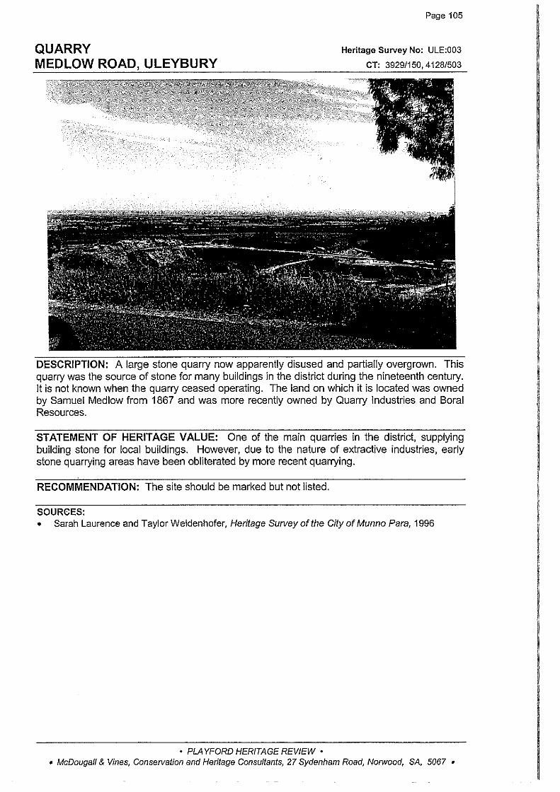
QUARRY MEDLOW ROAD, ULEYBURY
Page 105
Heritage Survey No: ULE:003
CT: 3929/150,4128/503
DESCRIPTION: A large stone quarry now apparently disused and partially overgrown. This quarry was the source of stone for many buildings in the district during the nineteenth century. It is not known when the quarry ceased operating. The land on which it is located was owned by Samuel Medlow from 1867 and was more recently owned by Quarry Industries and Bora! Resources.
STATEMENT OF HERITAGE VALUE: One of the main quarries in the district, supplying building stone for local buildings. However, due to the nature of extractive industries, early stone quarrying areas have been obliterated by more recent quarrying.
RECOMMENDATION: The site should be marked but not listed.
SOURCES: • Sarah Laurence and Taylor Weidenhofer, Heritage Survey of the City of Munno Para, 1996
• PLAYFORD HERITAGE REVIEW • • McDougall & Vines, Conservation and Heritage Consultants, 27 Sydenham Road, Norwood, SA, 5067 •

ULEY CEMETERY & CHAPEL SITE ULEY ROAD, ULEYBURY
Page 106
Heritage Survey No: ULE:004
CT: GD33 (GRO Deposit)
· DESCRIPTION: A group of gravestones partly surrounded by random coursed stone fence. Some grave sites have cast iron surrounds. There are remnant plantings of pines (yews?) remaining and also the footings of the original chapel. The cemetery was once associated with one of the earliest chapels to be built in the district. In 1851 a trusteeship of 14 people was formed to establish a Baptist Chapel, including Moses Bendle Garlick who donated a piece of land for the purpose. The chapel was completed in that year and was also used for a time as the meeting place for the District Council of Munno Para East. It was a simple stone construction which fell into disrepair in the 1960s and was subjected to active vandalism. The chapel was demolished in 1981. The adjacent cemetery contains the graves of early pioneers and it continued to be used until the mid twentieth century. Stone from the demolished chapel was used to construct a fence around the area.
STATEMENT OF HERITAGE VALUE: The site of one of the earliest chapels and cemeteries in the district, established by Moses Bendle Garlick, father of the noted architect Daniel Garlick.
RELEVANT CRITERIA: The Uley Cemetery and Chapel site fulfils criteria a, b, c, d and e under Section 23(4) of the Development Act 1993 as a place of local heritage value.
EXTENT OF LISTING: The cemetery site including the former 1850s chapel site, including the stone boundary wall which was built in the 1980s with the stone from the ruined chapel.
SOURCES: • Sarah Laurence and Taylor Weidenhofer, Heritage Survey of the City of Munno Para, 1996
• PLAYFORD HERITAGE REVIEW • • McDougall & Vines, Conservation and Heritage Consultants, 27 Sydenham Road, Norwood, SA, 5067 •
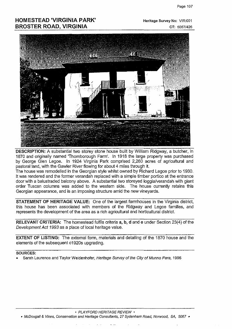
HOMESTEAD 'VIRGINIA PARK' BROSTER ROAD, VIRGINIA
Page 107
Heritage Survey No: VIR:001
CT: 5067/426
DESCRIPTION: A substantial two storey stone house built by William Ridgway, a butcher, in 1870 and originally named 'Thornborough Farm'. In 1918 the large property was purchased by George Glen Legoe. In 1924 Virginia Park comprised 2,260 acres of agricultural and pastoral land, with the Gawler River flowing for about 4 miles through it. The house was remodelled in the Georgian style whilst owned by Richard Legoe prior to 1930. It was rendered and the former verandah replaced with a simple timber portico at the entrance door with a balustraded balcony above. A substantial two storeyed loggia/verandah with giant order Tuscan columns was added to the western side. The house currently retains this Georgian appearance, and is an imposing structure amid the new vineyards.
STATEMENT OF HERITAGE VALUE: One of the largest farmhouses in the Virginia district, this house has been associated with members of the Ridgway and Legoe families, and represents the development of the area as a rich agricultural and horticultural district.
RELEVANT CRITERIA: The homestead fulfils criteria a, b, d and e under Section 23(4) of the Development Act 1993 as a place of local heritage value.
EXTENT OF LISTING: The external form, materials and detailing of the 1870 house and the elements of the subsequent c1920s upgrading.
SOURCES: • Sarah Laurence and Taylor Weidenhofer, Heritage Survey of the City of Munno Para, 1996
• PLAYFORD HERITAGE REVIEW • • McDougall & Vines, Conservation and Heritage Consultants, 27 Sydenham Road, Norwood, SA, 5067 •
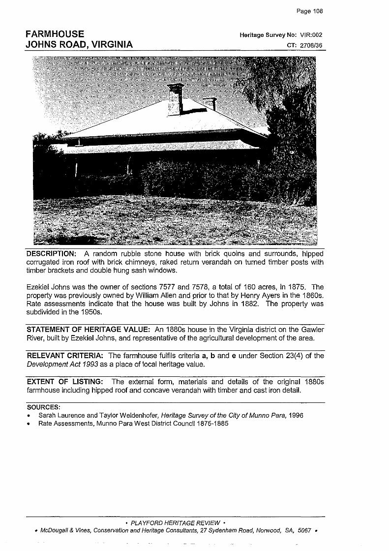
FARMHOUSE JOHNS ROAD, VIRGINIA
Page 108
Heritage Survey No: VIR:002
CT: 2708/36
DESCRIPTION: A random rubble stone house with brick quoins and surrounds, hipped corrugated iron roof with brick chimneys, raked return verandah on turned timber posts with timber brackets and double hung sash windows.
Ezekiel Johns was the owner of sections 7577 and 7578, a total of 160 acres, in 1875. The property was previously owned by William Allen and prior to that by Henry Ayers in the 1860s. Rate assessments indicate that the house was built by Johns in 1882. The property was subdivided in the 1950s.
STATEMENT OF HERITAGE VALUE: An 1880s house in the Virginia district on the Gawler River, built by Ezekiel Johns, and representative of the agricultural development of the area.
RELEVANT CRITERIA: The farmhouse fulfils criteria a, band e under Section 23(4) of the Development Act 1993 as a place of local heritage value.
EXTENT OF LISTING: The external form, materials and details of the original 1880s farmhouse including hipped roof and concave verandah with tirnber and cast iron detail.
SOURCES: • Sarah Laurence and Taylor Weidenhofer, Heritage Survey of the City of Munno Para, 1996 • Rate Assessments, Munno Para West District Council1875-1885
• PLAYFORD HERITAGE REVIEW • • McDougall & Vines, Conservation and Heritage Consultants, 27 Sydenham Road, Norwood, SA, 5067 •

Page 109
OUR LADY OF THE ASSUMPTION CATHOLIC CHURCH Hs No: VIR:oo3
PENFIELD ROAD, CNR LEACH STREET, VIRGINIA cT: 42221559
DESCRIPTION: A random rubble stone church with tuck pointing and brick quoins and surrounds, rendered base and brick caps to plinth, pilasters and parapet, circular headed windows with leadlighting, gabled roof clad with corrugated iron and decorative brickwork to gable end. A small gabled porch with slate roof is attached to the front elevation and there are gabled extensions to the rear. The land on which the church is built was donated by Daniel Brady, the founder of Virginia. The church was designed by the architect Michael McMullen and built by builders Niass and Jones. The foundation stone was laid in September 1861 (although it is no longer visible). The church cost £420 and was opened in March 1862. The church was enlarged in 1865 when the walls were raised two and a half feet and the roof eight feet. The sanctuary was also extended at this time.
STATEMENT OF HERITAGE VALUE: The first Catholic Church in Virginia, representative of development and expansion of religious denominations to the north of Adelaide in the mid nineteenth century.
RELEVANT CRITERIA: The Our Lady of the Assumption Catholic Church fulfils criteria a, b, c and d under Section 23(4) of the Development Act 1993 as a place of local heritage value.
• PLAYFORD HERITAGE REVIEW • • McDougall & Vines, Conservation and Heritage Consultants, 27 Sydenham Road, Norwood, SA, 5067 •

OUR LADY OF THE ASSUMPTION CATHOLIC CHURCH PENFIELD ROAD, CNR LEACH STREET, VIRGINIA (cant)
Page 110
EXTENT OF LISTING: The external form, materials and details of the 1860s church including decorative brick and stone vertical elements, gabled porch to the front elevation and rear gabled sections.
SOURCES: • Sarah Laurence and Taylor Weidenhofer, Heritage Survey of the City of Munno Para, 1996
• PLAYFORD HERITAGE REVIEW • • McDougall & Vines, Conservation and Heritage Consultants, 27 Sydenham Road, Norwood, SA, 5067 •
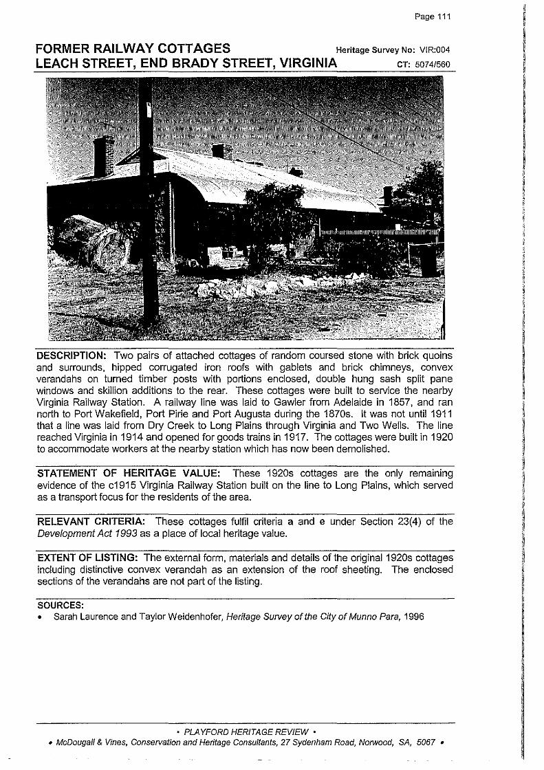
Page 111
FORMER RAILWAY COTTAGES Heritage Survey No: VIR:004
LEACH STREET, END BRADY STREET, VIRGINIA cT: 50741560
DESCRIPTION: Two pairs of attached cottages of random coursed stone with brick quoins and surrounds, hipped corrugated iron roofs with gablets and brick chimneys, convex verandahs on turned timber posts with portions enclosed, double hung sash split pane windows and skillion additions to the rear. These cottages were built to service the nearby Virginia Railway Station. A railway line was laid to Gawler from Adelaide in 1857, and ran north to Port Wakefield, Port Pirie and Port Augusta during the 1870s. It was not until 1911 that a line was laid from Dry Creek to Long Plains through Virginia and Two Wells. The line reached Virginia in 1914 and opened for goods trains in 1917. The cottages were built in 1920 to accommodate workers at the nearby station which has now been demolished.
STATEMENT OF HERITAGE VALUE: These 1920s cottages are the only rema1n1ng evidence of the c1915 Virginia Railway Station built on the line to Long Plains, which served as a transport focus for the residents of the area.
RELEVANT CRITERIA: These cottages fulfil criteria a and e under Section 23(4) of the Development Act 1993 as a place of local heritage value.
EXTENT OF LISTING: The external form, materials and details of the original 1920s cottages including distinctive convex verandah as an extension of the roof sheeting. The enclosed sections of the verandahs are not part of the listing.
SOURCES: • Sarah Laurence and Taylor Weidenhofer, Heritage Su/Vey oft he City of Munno Para, 1996
• PLAYFORD HERITAGE REVIEW • • McDougall & Vines, Conservation and Heritage Consultants, 27 Sydenham Road, Norwood, SA, 5067 •

VIRGINIA INSTITUTE OLD PORT WAKEFIELD ROAD, VIRGINIA
Page 112
Heritage Survey No: VIR:005
CT: 2/208
DESCRIPTION: A random rubble coursed stone building with hipped corrugated iron roof with gable! to front elevation with decorative bargeboard, brick quoins and surrounds to circular headed window openings, four paned windows with hopper sections to top and the name 'Institute' located under entrance gable. There is a modern glazed porch of appropriate design and recent brick extension to the rear.
The building was constructed and opened in 1908 and served as the social hub for the town of Virginia. It was used for social functions, church events as well as containing a library selection. Between 1969 and 1975 the National Bank occupied the building. With the assistance of sponsorship, Munno Para Council extensively upgraded and renovated the building, reopening it in 1987.
STATEMENT OF HERITAGE VALUE: The 1908 Institute building served as the education and social focus for the community of Virginia for more than fifty years, and is representative of the expansion of the Institute movement into rural areas in the early 20th century.
RELEVANT CRITERIA: The Institute fulfils criteria a, c and f under Section 23(4) of the Development Act 1993 as a place of local heritage value.
EXTENT OF LISTING: The external form, materials and details of the original 1908 building including hipped roof with small gable to the front elevation. The newer well designed entrance porch and rear brick extensions are not part of the listing.
SOURCES: • Sarah Laurence and Taylor Weidenhofer, Heritage Survey of the City of Munno Para, 1996
• PLAYFORD HERITAGE REVIEW • • McDougall & Vines, Conservation and Heritage Consultants, 27 Sydenham Road, N01wood, SA, 5067 •
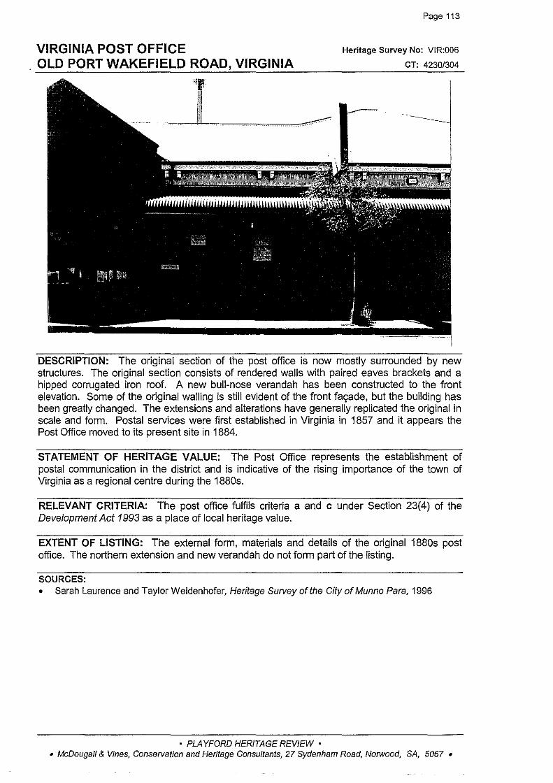
VIRGINIA POST OFFICE OLD PORT WAKEFIELD ROAD, VIRGINIA
Hi.·' ,.
ll ' f
Page 113
Heritage Survey No: VIR:006
CT: 4230/304
DESCRIPTION: The original section of the post office is now mostly surrounded by new structures. The original section consists of rendered walls with paired eaves brackets and a hipped corrugated iron roof. A new bull-nose verandah has been constructed to the front elevation. Some of the original walling is still evident of the front fagade, but the building has been greatly changed. The extensions and alterations have generally replicated the original in scale and form. Postal services were first established in Virginia in 1857 and it appears the Post Office moved to its present site in 1884.
STATEMENT OF HERITAGE VALUE: The Post Office represents the establishment of postal communication in the district and is indicative of the rising importance of the town of Virginia as a regional centre during the 1880s.
RELEVANT CRITERIA: The post office fulfils criteria a and c under Section 23(4) of the Development Act 1993 as a place of local heritage value.
EXTENT OF LISTING: The external form, materials and details of the original 1880s post office. The northern extension and new verandah do not form part of the listing.
SOURCES: • Sarah Laurence and Taylor Weidenhofer, Heritage Survey of the City of Munno Para, 1996
• PLAYFORD HERITAGE REVIEW • • McDougall & Vines, Conservation and Heritage Consultants, 27 Sydenham Road, Norwood, SA, 5067 •

Page 114
WHEATSHEAF HOTEL Heritage Survey No: VIR:007
OLD PORT WAKEFIELD RD, CNR PARK RD, VIRGINIA cr: 2615190
DESCRIPTION: The oldest section of this building is at the southern end and is constructed of random rubble stone. This building has been greatly extended and altered and has a tiled roof, metal framed windows and brick extensions. There is very little original fabric, or even fabric from the 1930s alterations remaining. There is a random rubble gabled stone barn with corrugated iron roof in the rear yard (former stables). The hotel was first licensed in 1855 to David Parker, and it was then a small stone building located on the main road from Adelaide to Port Wakefield drawing on the passing trade. In 1929 the hotel was extensively refurbished to the design of architect J S Rutter, which altered the exterior of the building to a Tudor style. Further additions were made to the building in the 1960s and in 1971 the fagade of the building was altered to its present style. Only the corner of the building on the Park Road, Old Port Wakefield Road intersection is part of the original structure. This has been severely compromised by the addition of an upper storey in an awkwardly formed roof which extends along the full frontage of both old and new structures. The building has also had its windows enlarged and changed, and the only original elements remaining are a small section of external wall and the openings for two doors. The frontage to Park Road has similarly been substantially altered and retains entry doors and one unchanged sash window.
STATEMENT OF HERITAGE VALUE: One of the earliest hotels in the district, located on the main road through the town, this hotel as served as a social focus for the community of Virginia. However, in its current form the building does not retain sufficient physical integrity to warrant listing
RECOMMENDATION: The inclusion of the Wheatsheaf hotel on the schedule of local heritage places is not recommended.
SOURCES: • Sarah Laurence and TaylorWeidenhofer, Heritage Survey of the CityofMunno Para, 1996 • Playford Local History Collection- research notes
• PLAYFORD HERITAGE REVIEW • • McDougall & Vines, Conservation and Heritage Consultants, 27 Sydenham Road, Norwood, SA, 5067 •
I I I
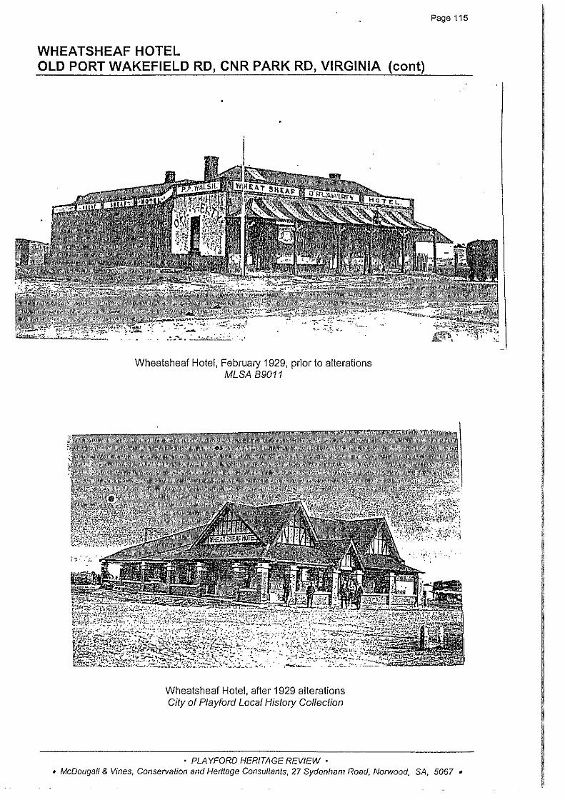
WHEATSHEAF HOTEL OLD PORT WAKEFIELD RD, CNR PARK RD, VIRGINIA (cant)
. . . _ . .. . ~~ ............ -~~·
Wheatsheaf Hotel, February 1929, prior to alterations MLSA 89011
Wheatsheaf Hotel, after 1929 alterations City of Playford Local History Collection
• PLAYFORD HERITAGE REVIEW •
Page 115
• McDougall & Vines, Conservation and Heritage Consultants, 27 Sydenham Road, Norwood, SA, 5067 •
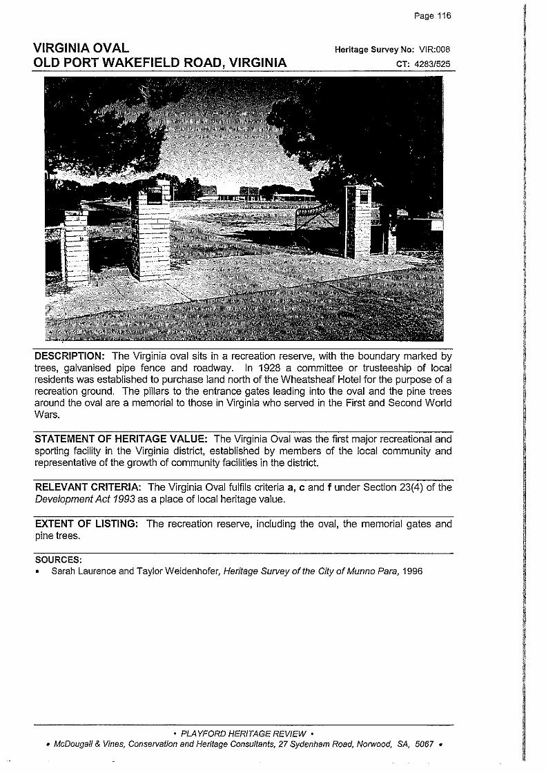
VIRGINIA OVAL OLD PORT WAKEFIELD ROAD, VIRGINIA
Page 116
Heritage Survey No: VIR:008
CT: 4283/525
DESCRIPTION: The Virginia oval sits in a recreation reserve, with the boundary marked by trees, galvanised pipe fence and roadway. In 1928 a committee or trusteeship of local residents was established to purchase land north of the Wheatsheaf Hotel for the purpose of a recreation ground. The pillars to the entrance gates leading into the oval and the pine trees around the oval are a memorial to those in Virginia who served in the First and Second World Wars.
STATEMENT OF HERITAGE VALUE: The Virginia Oval was the first major recreational and sporting facility in the Virginia district, established by members of the local community and representative of the growth of community facilities in the district.
RELEVANT CRITERIA: The Virginia Oval fulfils criteria a, c and f under Section 23(4) of the Development Act 1993 as a place of local heritage value.
EXTENT OF LISTING: The recreation reserve, including the oval, the memorial gates and pine trees.
SOURCES: • Sarah Laurence and TaylorWeidenhofer, Heritage Survey of the CityofMunno Para, 1996
• PLAYFORD HERITAGE REVIEW • • McDougall & Vines, Conservation and Heritage Consultants, 27 Sydenham Road, Norwood, SA, 5067 •

HOUSE PENFIELD ROAD, VIRGINIA
Page 118
Heritage Survey No: VIR:010
CT: 41861131
DESCRIPTION: A double fronted painted stone house with rendered quoins, surrounds and chimneys, hipped corrugated iron roof with decorative gable! to the front elevation, bull-nose verandah on turned timber posts with timber brackets and double hung sash windows.
In 1869 the owner of the property was William Baker, and rate assessments indicate that a house was constructed by Baker in 1871. The property remained in the Baker family until at least the 1960s, and the house was upgraded in the early 1900s. This property is listed as being located in the Peachey Belt in 1870.
STATEMENT OF HERITAGE VALUE: A significant early farmhouse in the area, associated with members of the Baker family, and representative of agricultural development on this section of Adelaide Plains.
RELEVANT CRITERIA: The house fulfils criteria a, b and e under Section 23(4) of the Development Act 1993 as a place of local heritage value.
EXTENT OF LISTING: The external form, materials and details of the original 1870s stone house including chimneys, and c1900 decorative gable to front elevation and bull-nose verandah.
SOURCES: • Sarah Laurence and Taylor Weidenhofer, Heritage Survey of the City of Munno Para, 1996 • Rate Assessment Books, District Council of Munno Para West, 1855-1875
• PLAYFORD HERITAGE REVIEW • • McDougall & Vines, Conservation and Heritage Consultants, 27 Sydenham Road, Norwood, SA, 5067 •
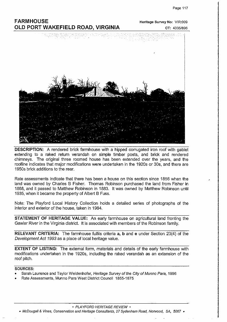
FARMHOUSE OLD PORT WAKEFIELD ROAD, VIRGINIA
Page 117
Heritage Survey No: VJR:009
CT: 4335/896
DESCRIPTION: A rendered brick farmhouse with a hipped corrugated iron roof with gablet extending to a raked return verandah on simple timber posts, and brick and rendered chimneys. The original three roomed house has been extended over the years, and the roofline indicates that major modifications were undertaken in the 1920s or 30s, and there are 1950s brick additions to the rear.
Rate assessments indicate that there has been a house on this section since 1856 when the land was owned by Charles B Fisher. Thomas Robinson purchased the land from Fisher in 1868, and it passed to Matthew Robinson in 1883. It was owned by Matthew Robinson until 1935, when it became the property of Albert B Fuss.
Note: The Playford Local History Collection holds a detailed series of photographs of the interior and exterior of the house, taken in 1984.
STATEMENT OF HERITAGE VALUE: An early farmhouse on agricultural land fronting the Gawler River in the Virginia district. It is associated with members of the Robinson family.
RELEVANT CRITERIA: The farmhouse fulfils criteria a, band e under Section 23(4) of the Development Act 1993 as a place of local heritage value.
EXTENT OF LISTING: The external form, materials and details of the early farmhouse with modifications undertaken in the 1920s, including the raked verandah as an extension of the roof pitch.
SOURCES: • Sarah Laurence and TaylorWeidenhofer, Heritage Surveyofthe CityofMunno Para, 1996 • Rate Assessments, Munno Para West District Council 1855-1875
• PLAYFORD HERITAGE REVIEW • • McDougall & Vines, Conservation and Heritage Consultants, 27 Sydenham Road, Norwood, SA, 5067 •
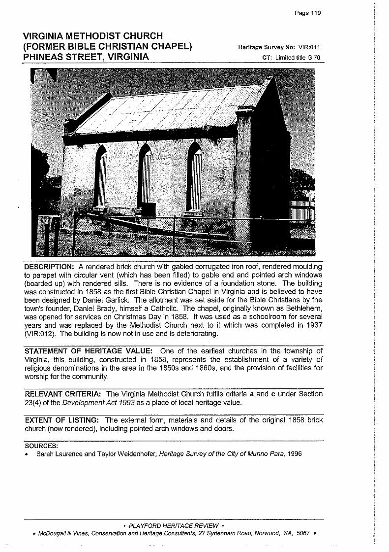
VIRGINIA METHODIST CHURCH (FORMER BIBLE CHRISTIAN CHAPEL) PHINEAS STREET, VIRGINIA
Page 119
Heritage Survey No: VIR:011
CT: Limited title G 70
DESCRIPTION: A rendered brick church with gabled corrugated iron roof, rendered moulding to parapet with circular vent (which has been filled) to gable end and pointed arch windows (boarded up) with rendered sills. There is no evidence of a foundation stone. The building was constructed in 1858 as the first Bible Christian Chapel in Virginia and is believed to have been designed by Daniel Garlick. The allotment was set aside for the Bible Christians by the town's founder, Daniel Brady, himself a Catholic. The chapel, originally known as Bethlehem, was opened for services on Christmas Day in 1858. It was used as a schoolroom for several years and was replaced by the Methodist Church next to it which was completed in 1937 (VIR:012). The building is now not in use and is deteriorating.
STATEMENT OF HERITAGE VALUE: One of the earliest churches in the township of Virginia, this building, constructed in 1858, represents the establishment of a variety of religious denominations in the area in the 1850s and 1860s, and the provision of facilities for worship for the community.
RELEVANT CRITERIA: The Virginia Methodist Church fulfils criteria a and c under Section 23(4) of the Development Act 1993 as a place of local heritage value.
EXTENT OF LISTING: The external form, materials and details of the original 1858 brick church (now rendered), including pointed arch windows and doors.
SOURCES: • Sarah Laurence and Taylor Weidenhofer, Heritage Survey of the City of Munno Para, 1996
• PLAYFORD HERITAGE REVIEW • • McDougall & Vines, Conservation and Heritage Consultants, 27 Sydenham Road, Norwood, SA, 5067 •
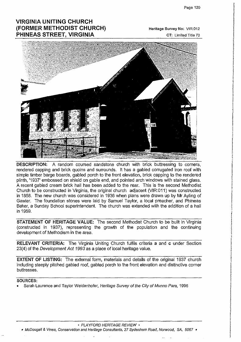
VIRGINIA UNITING CHURCH (FORMER METHODIST CHURCH) PHINEAS STREET, VIRGINIA
Page 120
Heritage Survey No: VIR:012
CT: Limited Title 70
DESCRIPTION: A random coursed sandstone church with brick buttressing to corners, rendered capping and brick quoins and surrounds. It has a gabled corrugated iron roof with simple timber barge boards, gabled porch to the front elevation, brick capping to the rendered plinth, '1937' embossed on shield on gable end, and pointed arch windows with stained glass. A recent gabled cream brick hall has been added to the rear. This is the second Methodist Church to be constructed in Virginia, the original church adjacent (VIR:011) was constructed in 1858. The new church was considered in 1936 when plans were drawn up by Mr Ayling of Gawler. The foundation stones were laid by Samuel Taylor, a local preacher, and Phineas Baker, a Sunday School superintendent. The church was extended with the addition of a hall in 1959.
STATEMENT OF HERITAGE VALUE: The second Methodist Church to be built in Virginia (constructed in 1937), representing the growth of the population and the continuing development of Methodism in the area.
RELEVANT CRITERIA: The Virginia Uniting Church fulfils criteria a and c under Section 23(4) of the Development Act 1993 as a place of local heritage value.
EXTENT OF LISTING: The external form, materials and details of the original 1937 church including steeply pitched gabled roof, gabled porch to the front elevation and distinctive corner buttresses.
SOURCES: • Sarah Laurence and Taylor Weidenhofer, Heritage Survey of the City of Munno Para, 1996
• PLAYFORD HERITAGE REVIEW • • McDougall & Vines, Conservation and Heritage Consultants, 27 Sydenham Road, Norwood, SA, 5067 •
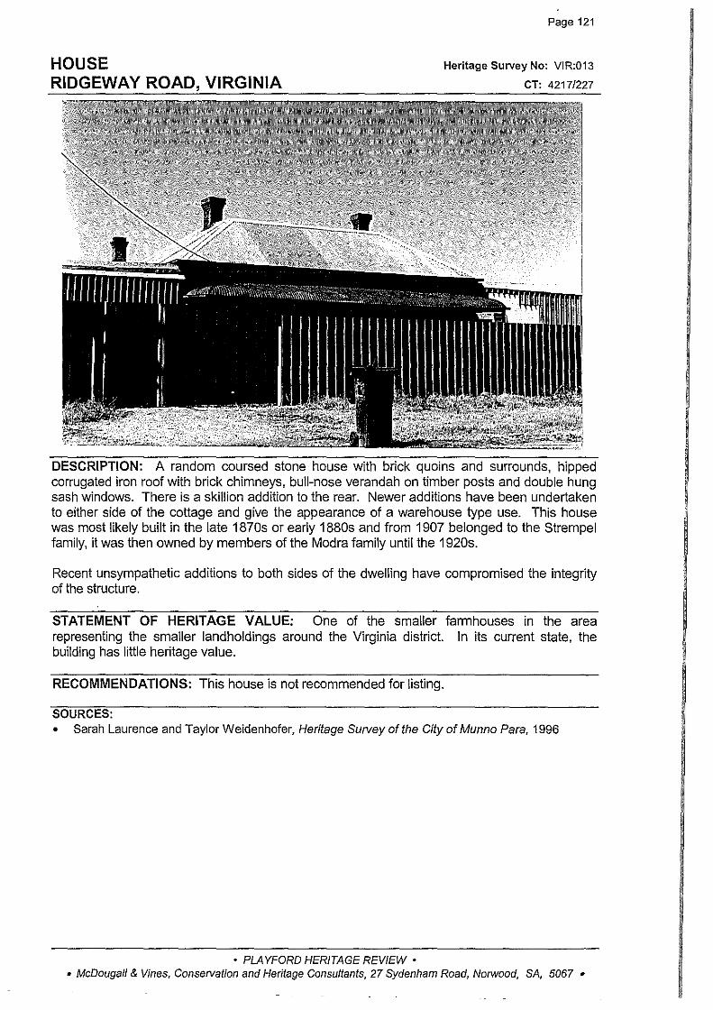
HOUSE RIDGEWAY ROAD, VIRGINIA
Page 121
Heritage Survey No: VIR:013
CT: 4217/227
DESCRIPTION: A random coursed stone house with brick quoins and surrounds, hipped corrugated iron roof with brick chimneys, bull-nose verandah on timber posts and double hung sash windows. There is a skill ion addition to the rear. Newer additions have been undertaken to either side of the cottage and give the appearance of a warehouse type use. This house was most likely built in the late 1870s or early 1880s and from 1907 belonged to the Strempel family, it was then owned by members of the Madra family until the 1920s.
Recent unsympathetic additions to both sides of the dwelling have compromised the integrity of the structure.
STATEMENT OF HERITAGE VALUE: One of the smaller farmhouses in the area representing the smaller landholdings around the Virginia district. In its current state, the building has little heritage value.
RECOMMENDATIONS: This house is not recommended for listing.
SOURCES: • Sarah Laurence and Taylor Weidenhofer, Heritage Survey of the City of Munno Para, 1996
• PLAYFORD HERITAGE REVIEW • • McDougall & Vines, Conservation and Heritage Consultants, 27 Sydenham Road, Norwood, SA, 5067 •

Page 122
HOUSE 'ALMOND GROVE' Heritage Survey No: VIR:014
ROBERT ROAD, CNR MOLONEY ROAD, VIRGINIA cr: 2764196
··~-~
DESCRIPTION: A random rubble stone house with brick quoins and surrounds, hipped corrugated iron roof with brick chimney, concave return verandah on timber posts and double hung sash windows. There is a small random rubble stone outbuilding at the rear with hipped corrugated iron roof, brick quoins and surrounds, and casement windows. The section of land on which this house sits was granted to William and Eli Jellett in 1853. By the time rate assessments began in 1856, the land was occupied by William Zimmerman and a house was recorded on the property. The first certificate of title was issued to John Rowland in 1861, for a section comprising 81 acres., It is likely that the house was rebuilt or added to during the 1870s. The property remained in the Rowland family until at least the 1950s. In the 1960s the Section was divided into four allotments and the allotment with the house was sold at that time to the Franciscan Friars Minor Conventual Inc.
STATEMENT OF HERITAGE VALUE: An c1860 farmhouse, associated with members of the Rowland family, pioneer farmers in the district, and representative of agricultural development in the area.
RELEVANT CRITERIA: The house fulfils criteria a, b and e under Section 23(4) of the Development Act 1993 as a place of local heritage value.
EXTENT OF LISTING: The external form, materials and details of the original 1860s house, including return verandah and distinctive rear section with hipped roof and casement windows.
SOURCES: • Sarah Laurence and Taylor Weidenhofer, Heritage Survey of the City of Munno Para, 1996
• PLAYFORD HERITAGE REVIEW • • McDougall & Vines, Conservation and Heritage Consultants, 27 Sydenham Road, Norwood, SA, 5067 •
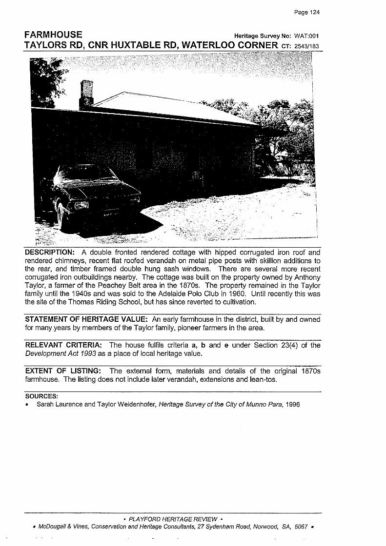
Page 124
FARMHOUSE HeritageSurveyNo: WAT:001
TAYLORS RD, CNR HUXTABLE RD, WATERLOO CORNER cr: 2543/183
'
A double fronted rendered cottage with hipped corrugated iron roof and rendered chimneys, recent flat roofed verandah on metal pipe posts with skillion additions to the rear, and timber framed double hung sash windows. There are several more recent corrugated iron outbuildings nearby. The cottage was built on the property owned by Anthony Taylor, a farmer of the Peachey Belt area in the 1870s. The property remained in the Taylor family until the 1940s and was sold to the Adelaide Polo Club in 1960. Until recently this was the site of the Thomas Riding School, but has since reverted to cultivation.
STATEMENT OF HERITAGE VALUE: An early farmhouse in the district, built by and owned for many .years by members of the Taylor family, pioneer farmers in the area.
RELEVANT CRITERIA: The house fulfils criteria a, b and e under Section 23(4) of the Development Act 1993 as a place of local heritage value.
EXTENT OF LISTING: The external form, materials and details of the original 1870s farmhouse. The listing does not include later verandah, extensions and lean-los.
SOURCES: • Sarah Laurence and Taylor Weidenhofer, Heritage Swvey of the City of Munno Para, 1996
• PLAYFORD HERITAGE REVIEW • • McDougall & Vines, Consetvation and Heritage Consultants, 27 Sydenham Road, Norwood, SA, 5067 •

Page 123
HOUSE I CALVIN GROVE' Heritage Survey No: VIR:015
T VIRGINIA CT: 4348/7 43
DESCRIPTION: A rendered double fronted house with rendered quoins Hipped corrugated iron roof with rendered chimneys, raked return verandah on sirnple tirnber posts and double hung sash windows. There is new latticework to the verandah balustrade. The property was owned by the March family from 1853 until 1863 when Anthony Taylor purchased the section. In 1866 and 1875 Taylor took out mortgages on the property, indicating that the house may have been built around this time. The property was subdivided sometime after 1952.
STATEMENT OF HERITAGE VALUE: An early farmhouse, c1870, built by and owned for many years by members of the Taylor family. It is representative of the development of agriculture in the district.
RELEVANT CRITERIA: The house fulfils criteria a, b and e under Section 23(4) of the Development Act 1993 as a place of local heritage value.
EXTENT OF LISTING: The external form, materials and details of the original 1860s-70s farmhouse, including raked return verandah on simple tirnber posts.
SOURCES: • Sarah Laurence and Taylor Weidenhofer, Heritage Survey of the City of Munno Para, 1996
• PLAYFORD HERITAGE REVIEW • • McDougall & Vines, Conservation and Heritage Consultants, 27 Sydenham Road, Norwood, SA, 5067 •

Page 125
STONE WALL 'YATTALUNGA' Heritage Survey No: YAT:001
GAWLER-ONE TREE HILL ROAD, YATTALUNGA cT: 4381/605
DESCRIPTION: A random rubble dry stone wall on road boundary of property 'Yattalunga'. The wall once formed the boundary walling for nearby Yattalunga Homestead which was established in the 1850s. The property was subdivided in the 1950s, but there is a substantial section of wall still remaining.
STATEMENT OF HERITAGE VALUE: An early and substantial dry stone wall, once associated with the nearby 'Yattalunga' property, established in the 1850s.
RELEVANT CRITERIA: The stone wall fulfils criteria a, b, d and e under Section 23(4) of the Development Act 1993 as a place of local heritage value.
EXTENT OF LISTING: The circa 1850s random dry stone wall.
SOURCES: • Sarah Laurence and Taylor Weidenhofer, Heritage Survey of the City of Munno Para, 1996
• PLAYFORD HERITAGE REVIEW • • McDougall & Vines, Conservation and Heritage Consultants, 27 Sydenham Road, Norwood, SA, 5067 •

HOUSE 'MIL TON BANK' HUMBUG SCRUB ~u.M.u.
·'''" '""~ ~
:i¥o~_::l-~'-~!.::::· ·:
Page 126
Heritage Survey No: YAT:003
CT: 4127/79
DESCRIPTION: This building was constructed by Alexander Grant, owner of the nearby 'Yattalunga' property, in the early 1860s,and it was originally intended to be a coach house. William Bowman purchased Milton Bank and reconstructed the building, converting it to a two storey stone house, with stone outbuildings and farm sheds. The house and outbuildings are currently unused and have fallen into disrepair, although the stonework appears intact.
STATEMENT OF HERITAGE VALUE: A complex of early buildings in the area, initially associated with the development of the significant 'Yattalunga' property, and also the development of pastoral activities in the area of both Alexander Grant and William Bowman.
RELEVANT CRITERIA: The house fulfils criteria a, b, d and e under Section 23(4) of the Development Act 1993 as a place of local heritage value.
EXTENT OF LISTING: External form, details and materials of the c1870 stone house, outbuildings and sheds. Note that these require substantial repair and maintenance.
SOURCES: • Sarah Laurence and Taylor Weidenhofer, Heritage Survey ofthe City of Munno Para, 1996
• PLAYFORD HERITAGE REVIEW • • McDougall & Vines, Conservation and Heritage Consultants, 27 Sydenham Road, Norwood, SA, 5067 •
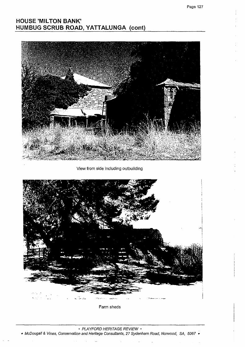
Page 127
HOUSE 'MIL TON BANK' HUMBUG SCRUB ROAD, YATTALUNGA (cant)
View from side including outbuilding
Farm sheds
• PLAYFORD HERITAGE REVIEW • • McDougall & Vines, Conservation and Heritage Consultants, 27 Sydenham Road, Norwood, SA, 5067 •

HUMBUG SCRUB COTTAGE OFF HUMBUG SCRUB ROAD, YATTALUNGA
Page 128
Heritage Survey No: YAT:004
CT: 1250/127
DESCRIPTION: A circa 1919 cottage constructed of lath and pug with gabled corrugated iron roof and brick chimney, six paned casement sash windows, and raked verandah on timber posts to the front elevation. The cottage was built circa 1919 to replace a slab hut which was located nearby. It lies in the Humbug Scrub Sanctuary which has operated since 1905 and was set up by Thomas Bellchambers.
STATEMENT OF HERITAGE VALUE: An early building in the Humbug Scrub/Hamlins Gully area, notable for its association with Thomas Bellchambers, who was an early 'conservationist' in the district and in South Australia.
RELEVANT CRITERIA: The cottage fulfils criteria e under Section 23(4) of the Development Act 1993 as a place of local heritage value.
EXTENT OF LISTING: The external form, materials and details of the original circa 1919 cottage including the raked verandah and external chimney.
SOURCES: • Sarah Laurence and Taylor Weidenhofer, Heritage Survey of the City of Munno Para, 1996
• PLAYFORD HERITAGE REVIEW • • McDougall & Vines, Conservation and Heritage Consultants, 27 Sydenham Road, Norwood, SA, 5067 •
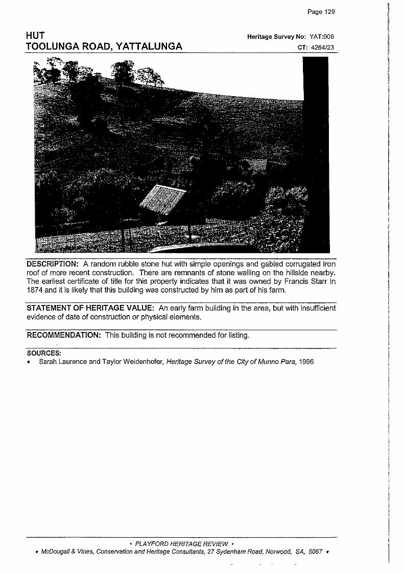
HUT TOOLUNGA ROAD, YATTALUNGA
Page 129
Heritage Survey No: YAT:006
CT: 4264/23
DESCRIPTION: A random rubble stone hut with simple openings and gabled corrugated iron roof of more recent construction. There are remnants of stone walling on the hillside nearby. The earliest certificate of title for this property indicates that it was owned by Francis Starr in 187 4 and it is likely that this building was constructed by him as part of his farm.
STATEMENT OF HERITAGE VALUE: An early farm building in the area, but with insufficient evidence of date of construction or physical elements.
RECOMMENDATION: This building is not recommended for listing.
SOURCES: • Sarah Laurence and Taylor Weidenhofer, Heritage Survey of the City of Munno Para, 1996
• PLAYFORD HERITAGE REVIEW • • McDougall & Vines, Consetvation and Heritage Consultants, 27 Sydenham Road, Norwood, SA, 5067 •
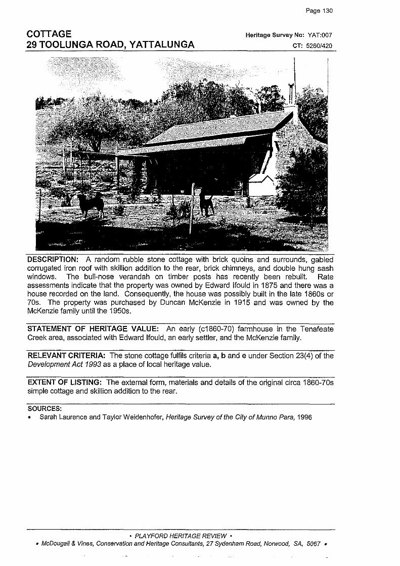
COTTAGE 29 TOOLUNGA ROAD, YATTALUNGA
Page 130
Heritage Survey No: YAT:007
CT: 5260/420
DESCRIPTION: A random rubble stone cottage with brick quoins and surrounds, gabled corrugated iron roof with skillion addition to the rear, brick chimneys, and double hung sash windows. The bull-nose verandah on timber posts has recently been rebuilt. Rate assessments indicate that the property was owned by Edward lfould in 1875 and there was a house recorded on the land. Consequently, the house was possibly built in the late 1860s or 70s. The property was purchased by Duncan McKenzie in 1915 and was owned by the McKenzie family until the 1950s.
STATEMENT OF HERITAGE VALUE: An early (c1860-70) farmhouse in the Tenafeate Creek area, associated with Edward lfould, an early settler, and the McKenzie family.
RELEVANT CRITERIA: The stone cottage fulfils criteria a, b and e under Section 23(4) of the Development Act 1993 as a place of local heritage value.
EXTENT OF LISTING: The external form, materials and details of the original circa 1860-?0s simple cottage and skillion addition to the rear.
SOURCES: • Sarah Laurence and Taylor Weidenhofer, Heritage Survey of the City of Munno Para, 1996
• PLAYFORD HERITAGE REVIEW • • McDougall & Vines, Conservation and Heritage Consultants, 27 Sydenham Road, Norwood, SA, 5067 •