city of san antonio limited purpose … us 281 north planning study and regulatory plan july 24,...
TRANSCRIPT

Draft US 281 North Planning Study and Regulatory Plan July 24, 2015 1
CITY OF SAN ANTONIO LIMITED PURPOSE ANNEXATION PLANNING STUDY for
US 281 NORTH Introduction In areas annexed for limited purposes, cities may extend planning, health and safety ordinances, including building and zoning codes. City sale and property taxes are not assessed. The City is not required to provide municipal services in areas annexed for limited purposes. Residents may vote in City Council and Charter elections but may not vote on proposals to issue bonds. Areas annexed for limited purposes must convert to full purpose jurisdiction prior to the end of the third year of limited purpose annexation. Upon full purpose annexation, an area becomes part of the city for all purposes. City property and sales taxes are assessed, all city ordinances are enforced, and the city provides services as required by state law. The City of San Antonio Department of Planning and Community Development (City) has prepared a “Planning Study” and “Regulatory Plan,” for the limited purpose annexation of US 281 North area as required by the Texas Local Government Code, (TX LGC) Section 43‐123. Area Description The US 281 North limited purpose annexation area consists of approximately 7,621 acres (12.01 square miles) in Bexar and Comal Counties. This annexation area is located along US 281 North, and falls within the City’s Extraterritorial Jurisdiction (ETJ). Currently the proposed annexation area is a mix of developed and undeveloped parcels. Land use is a mix of mostly single and some multi‐family housing, followed by farm and ranch land, and commercial uses, with less than 1% industrial uses. According to the 2010 US Census, there are approximately 24,936 residents in the proposed annexation area. This study area has experienced rapid growth in recent years, and is expected to nearly double in population to 43,940 in 20 years.
Profile of US 281 Annexation Area
US 281 Study Area Existing Projected 20 Year
Population 24,936 43,940
Single Family Units 9,053 12,299
Commercial Acres 646 1,299
Multi‐Family Acres 77 159
Median Home Value (Current) $277,365 ***
Current median single family residential property value is $227,365, with 24 Master Development Plan communities. The study area is adjacent to two existing long‐term non‐annexation agreements with both Timberwood Park and Lumbermen’s Investment Corporation. The Timberwood Park non‐annexation agreement covers 4,345 acres around the annexation area, from Camp Bullis along Borgfeld Road to Bulverde Road. This non‐annexation agreement expires in 2033. The Lumbermen’s non‐annexation area wraps from Bulverde Road around Fossil Ridge MDP, around the TPC golf course, and to the north of Indian Springs MDP. Lumbermen’s Investment Corporation consented to voluntary annexation upon the expiration of the non‐annexation agreement in 2034.
Draft US 281 North Planning Study and Regulatory Plan July 24, 2015 2
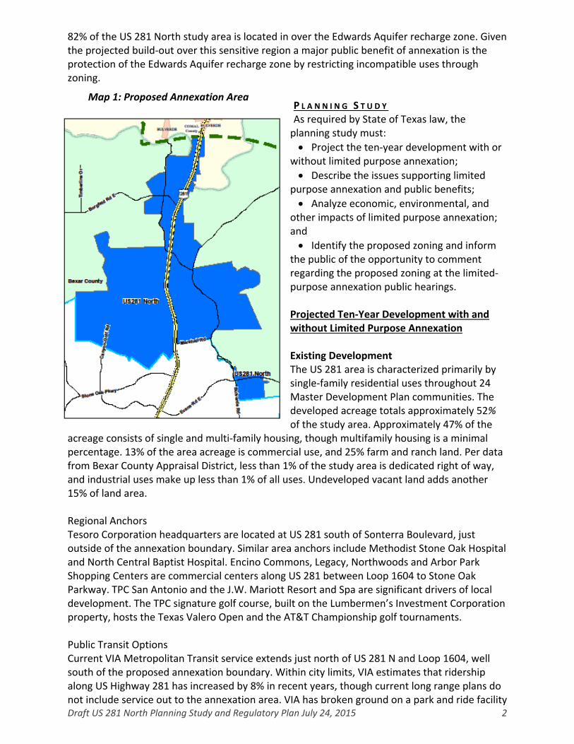
82% of the US 281 North study area is located in over the Edwards Aquifer recharge zone. Given the projected build‐out over this sensitive region a major public benefit of annexation is the protection of the Edwards Aquifer recharge zone by restricting incompatible uses through zoning.
P L A N N I N G S T U D Y As required by State of Texas law, the planning study must:
Project the ten‐year development with or without limited purpose annexation;
Describe the issues supporting limited purpose annexation and public benefits;
Analyze economic, environmental, and other impacts of limited purpose annexation; and
Identify the proposed zoning and inform the public of the opportunity to comment regarding the proposed zoning at the limited‐purpose annexation public hearings. Projected Ten‐Year Development with and without Limited Purpose Annexation Existing Development The US 281 area is characterized primarily by single‐family residential uses throughout 24 Master Development Plan communities. The developed acreage totals approximately 52% of the study area. Approximately 47% of the
acreage consists of single and multi‐family housing, though multifamily housing is a minimal percentage. 13% of the area acreage is commercial use, and 25% farm and ranch land. Per data from Bexar County Appraisal District, less than 1% of the study area is dedicated right of way, and industrial uses make up less than 1% of all uses. Undeveloped vacant land adds another 15% of land area. Regional Anchors Tesoro Corporation headquarters are located at US 281 south of Sonterra Boulevard, just outside of the annexation boundary. Similar area anchors include Methodist Stone Oak Hospital and North Central Baptist Hospital. Encino Commons, Legacy, Northwoods and Arbor Park Shopping Centers are commercial centers along US 281 between Loop 1604 to Stone Oak Parkway. TPC San Antonio and the J.W. Mariott Resort and Spa are significant drivers of local development. The TPC signature golf course, built on the Lumbermen’s Investment Corporation property, hosts the Texas Valero Open and the AT&T Championship golf tournaments. Public Transit Options Current VIA Metropolitan Transit service extends just north of US 281 N and Loop 1604, well south of the proposed annexation boundary. Within city limits, VIA estimates that ridership along US Highway 281 has increased by 8% in recent years, though current long range plans do not include service out to the annexation area. VIA has broken ground on a park and ride facility
Map 1: Proposed Annexation Area

Draft US 281 North Planning Study and Regulatory Plan July 24, 2015 3
at US 281 and Stone Oak Parkway, and will offer access to buses, carpools, and van pools in anticipation of the expansion of US 281. Schools Currently Comal Independent School District (CISD) has three elementary schools: Indian Springs, Kinder Ranch and Specht, serving the study area. Spring Branch and Smithson Valley Middle schools draw attendance from the northern US 281 area. Residents living north of Overlook Parkway and US 281 attend Smithson Valley High School. CISD’s Board of Education called a successful $147 million bond in early 2015. This bond will finance the construction of a middle school at Kinder Ranch anticipated to open in 2018. CISD also retains land in the same area with long range plans for a high school expected to open 2021. North‐East Independent School District (NEISD) currently has six elementary schools: Bulverde Creek, Roan Forest, Hardy Oak, Canyon Ridge, Cibolo Green, and Tuscany Heights; four middle schools: Lopez, Tex Hill, Tejeda, and Bush; and two high schools: Reagan and Johnson, serving the study area. There are no current plans for new school construction in the NEISD portion of the US 281 annexation area. Most NEISD schools in this area were constructed within the last 10 – 15 years, and as such, renovations are expected to be infrequent in the near term. Transportation US 281 north of Loop 1604 has been ranked among Texas’s top congested corridors. The Texas Department of Transportation (TxDOT), in partnership with the Alamo Regional Mobility Authority (RMA) has undertaken a $458 million project to expand capacity of US 281 North along eight miles between US Loop 1604 and Borgfeld Road, south of the Bexar‐Comal County Line. TxDOT and the Alamo RMA will invest $228 million in the project, leveraging revenue from managed toll lanes to cover the balance. Currently, the project is undergoing environmental review, with a bidding process loosely anticipated to begin in spring 2016. Schematics depict managed lanes, two freeway lanes, and frontage road in both north and south directions with additional plans for storm‐water management. Design specifications will follow from the bid process. The large scale of expansion is intended to mitigate the impact of rapid growth in this area and increase the capacity of this thoroughfare. As this project eases congestion and facilitates mobility to the urban core, significant residential and commercial development is anticipated in the study area. Further improvements to major arterials and roadways discussed below will work in tandem with the US 281 expansion to catalyze further commercial and residential development. The San Antonio Major Thoroughfare Plan (MTP) is a long range infrastructure plan for the City and Bexar County. It shows the future location, dimension and right‐of way dedication of major roadways. The MTP has designated Evans Road as a Primary Type A arterial with a 120’ right of way. Stone Oak Parkway, Wilderness Oak, Bulverde Road, Borgfeld Road, Marshall Road, Smithson Valley Road and Canyon Golf Road are all designated as Secondary Type A Arterials under the MTP, with a standard 86’ right of way. These MTP projects are currently at differing levels of implementation. Bexar County has many anticipated and ongoing public works and transportation plans for the US 281 annexation area. In 2009 Bexar County, in partnership with the City of San Antonio, NEISD and private developers began a five phase bond project along Bulverde Road. Phase one covered a .75 mile stretch with four lanes of travel, left turns and four foot shoulders with drainage. The second phase included 1.5 miles of two lanes, a continuous center turn lane, and
Draft US 281 North Planning Study and Regulatory Plan July 24, 2015 4
drainage improvements. Phase 3 will build on the prior phases, extending the project by 1.2 miles. Phases 4 and 5 will span Marshall Road to Wilderness Oak, and from Marshall Road to Smithson Valley Road. Construction is expected to end in the third quarter of 2015. And a more recent 2015‐2019 Transportation Improvement Project through the Alamo area Metropolitan Planning Organization will further expand Bulverde Road between Marshall Road and Wilderness Oak, from two to four lanes of traffic in fiscal year 2015. Bexar County Public Works Department is also in the preliminary design phase for pedestrian and bicycle improvements along Bulverde Road between Evans and Marshall Roads. A 2003 Bexar County Public Works Department bond reconstructed a little over a mile of Borgfeld Road into a Secondary Arterial Type “A” street, with drainage culverts. Bidding opened in 2013, and construction is expected to be complete in the third quarter of 2015. At Marshall Road along the annexation boundary, Bexar County is currently crafting plans for road reconstruction to expand from two to three lanes with drainage improvements and pedestrian amenities. This project does not yet have a timeline. Water Resources San Antonio Water System (SAWS) is the primary water and wastewater service provider in the area with The Estates at Stonegate providing service to the subdivision north of Oliver Ranch at US 281. SAWS promotes water quality by enforcing federal permit requirements for treatment of storm water runoff. The annexation area as a whole is located in the SAWS certificate of convenience and necessity (CNN) service area. Many of the US 281 residents in large lot developments rely on well water and septic systems to meet their water and wastewater needs. The Edwards Aquifer Authority and Texas Commission on Environmental Quality retain data on well and septic permits that show wells concentrated around the US 281 roadway, along the southern annexation boundary, and throughout some of the subdivided neighborhoods to the east of US 281. Septic tanks are concentrated along the US 281 roadway, and throughout Sendero Ranch, the subdivision north of Oliver Ranch, and just south of the Coronado Subdivision. The southern portion of the Goldtree MDP and area south of Evans road also features a high number of septic permits. Utility Service Agreements (USA) are in place for the Indian Springs MDP, extending into the Lumbermen’s non‐annexation area; Sendero Ranch; Coronado MDP; Marshall Road Apartments; Boulders at Canyon Springs MDP; Wilderness Oak Town Center at Moretti MDP; Overlook Town Center north of Sendero Ranch; Weekley 281 at Bulverde Road; the Bass MDP; a segment of the Indian Springs Corporation MDP; Kinder Ranch MDP; and Royal Oak Estates spanning the Annexation boundary where Bulverde Road crosses US 281. Existing USA sewer and water pipes are located between Marshall Road in Dolan Place 2 along US 281, between Indian Springs MDP and the Lumbermen’s non‐annexation boundary, along Borgfeld Road south of Willis Ranch, at Belterra on US 281, and at the annexation boundary just northwest of the Links at Canyon Springs MDP. Additional water pipes follow US 281 along Moretti Ranch MDP. SAWS has one District Special Project (DSP) capital improvement scheduled for 2017 where Canyon Golf Road meets the southern‐most boundary of the US 281 annexation area. Capital improvement sewer projects are anticipated for 2010–2015 at Bulverde Road just south of Evans Road. For 2016‐2020, improvements are planned for the Mud Creek‐way between

Draft US 281 North Planning Study and Regulatory Plan July 24, 2015 5
Canyon Springs Ranch and the western creek tributary in Oliver Ranch MDP. SAWS sewer projects in the annexation area are expected to total $3,850,000 in investment.
Anticipated 2017 water projects are planned at US 281 North along De la Vega MDP; along Borgfeld road west of 281 and into the Country Place neighborhood on the east; between Indian Springs MDP into the Lumbermen’s non‐annexation area; and along the southern border of Marshall Ranch MPD. Capital improvement projects planned for 2027 run along US 281 from Oliver Ranch to Bulverde Road, following along the Timberwood Park non‐annexation agreement. These projects are anticipated to total $6,325,520 in infrastructure investment.
New Development
There are currently 24 Master Development Plan communities in the US 281 annexation area. Most MDPs in the study area were platted over the past few decades and evidence a level of development that is expected to continue through the next 20 years.
Subdivision/Master Development Plan
Total Acres
Residential Acres
Single Fam. Res. Units
Commercial Acres
Multi‐Family
Bass 34 0 0 34 0
Bass Development 38 0 0 38 0
Belterra Subdivision 70 38 202 0 0
Bulverde Crossing 15 0 0 13 0
Canyon Springs Ranch 1,684 1,206 3,678 118 58
Coronado 116 95 337 20 0
De la Vega 190 190 621 0 0
Dolan Place 1 22 0 0 22 0
Dolan Place 2 20 0 0 20 0
Fuentes Property 76 76 237 0 0
Goldtree 180 167 85 13 0
HDS – Bulverde 14 0 0 14 0
Indian Springs 1,480 1,242 4,355 26 20
Indian Springs Corporation 238 0 0 238 0
Laredo Springs Amendment 523 519 1,111 0 0
Marshall Ranch 78 0 0 78 0
Moretti Subdivision 32 14 0 18 14
Oliver Ranch 524 376 1,241 53 0
San Miguel Subdivision Unit 1
35 35 137 0 0
Sendero Ranch 634 569 166 65 0
The Boulders at Canyon Springs
28 28 94 0 0
The Links at Canyon Springs 52 52 181 0 0
Tuscan Oaks 114 52 178 11 0
Willis Ranch 128 74 323 13 0
Total 6,269 4,787 12,946 912 92

Draft US 281 North Planning Study and Regulatory Plan July 24, 2015 6
Note: Development estimates assume a Master Development Plan has a 20 year build out. Currently approximately 10 acres of multifamily, 259 acres of commercial, and 9,700 single family units are built out.
Residential and commercial development is expected to continue over the next 10 years with or without annexation. Upcoming improvements to highway US 281 North are expected to spur commercial development along the expanded roadway. The proximity to a high density commercial center, hospitals, a corporate headquarters, the J.W. Marriott resort and spa, the TPC golf course and quality schools collectively make this an attractive area for future development. Issues supporting and Public Benefits of Limited Purpose Annexation Limited purpose annexation would extend zoning and city codes to address public health and safety, and ensure higher minimum development standards in residential and commercial development. Annexation would also protect the city’s vitality within the region as an economic center by providing certainty and predictability. In addition, annexation would allow the City of San Antonio to protect the long term viability of the Edward’s Aquifer, while also preserving U.S. military missions through land use controls. Annexation also facilitates long range planning in environmentally sensitive areas and growth centers and enhances the City’s overall regional economic position in bringing new jobs, population and investment to the area. Limited purpose annexation of the US 281 study area advances key long range planning goals articulated in the City of San Antonio’s 1997 Master Plan and 2010 North Sector plan. In particular, from the 1997 plan annexation would ensure the following:
Proposed land uses and development are
appropriate in use, character and size to the site and the surrounding areas.
Develop ordinances protecting valuable natural and cultural resources and promoting energy and water conservation.
Encourage public participation in the land‐use decision making process.
Encourage links between zoning and goals of the community by promoting neighborhood involvement.
Provide an adequate level of municipal services; protect the City of San Antonio’s long term water source.
Encourage retention of the 100 year flood plain as water drainage without permanent construction, unnecessary straightening, bank clearing or channeling.
Map 2: Edwards Aquifer and Karst Zones

Draft US 281 North Planning Study and Regulatory Plan July 24, 2015 7
The North Sector plan outlines the following desirable outcomes consistent with the City’s limited purpose annexation plans:
Encourage compatible growth patterns by focusing higher density around principal arterials and corridors.
Establish compatible economic development along major transportation routes and existing activity centers that do not interfere with the mission of Camp Bullis.
Ensure Camp Bullis’ continued significance as a component of San Antonio’s military and residential economy.
Edwards Aquifer Recharge and Contributing Zones are protected as the City’s primary potable water source.
Natural Hill Country features such as steep slopes, soils, native trees and natural vistas are protected.
Natural tree canopy is conserved and managed to provide natural storm water mitigation, shade and improved air quality.
Endangered species are protected.
Historic trails, sites, cemeteries and ridges are preserved and promoted.
Compatible land use patterns are promoted so that natural resources are preserved and the local economy remains viable.
Locate buffers between high density and intensity land uses that are potentially incompatible.
High density and intensity tiers are recommended adjacent or proximate to activity centers.
All construction and renovation efforts within corridor overlay districts must be in compliance with applicable standards
Future land uses should be compatible with the continued operation of Camp Bullis to avoid risks to civilian and military aviators, life, property and the well‐being of existing future residents from hazards associated with fixed‐wing and rotary wing aircraft operations, firing ranges, operations and training.
Limited purpose annexation will establish a regulatory framework for the area to protect public health and safety. Limited purpose annexation provides the tools to regulate the type and character of development and redevelopment through the application of zoning, site development standards, building codes and other regulatory tools not available in unincorporated Bexar County. Annexation will allow more stringent International Building Codes to apply to all construction projects in the extended city limits. In Texas, county building permits may be issued only for a commercial establishment or multifamily dwelling. The State does not permit counties to require approval prior to beginning new residential construction (Local Government Code, Sec. 233.0615). Permits are not required for single family or duplex residential construction by Bexar County. For commercial and multifamily projects, Bexar County utilizes and references the 2009 International Code Series and amendments found in the Bexar County Rules for the Enforcement of the International Fire Code and International Building Codes. References are also made to the National Fire Protection Association standards and other pertinent state laws. The application of Building Codes regulating minimum construction standards and inspections referenced in Chapter 6 and 10 of the City of San Antonio Municipal Code will ensure that new residential and non‐residential buildings are safe for habitation, meet minimum standards to secure financing from lenders, and hold value over the long term. This includes application of
Draft US 281 North Planning Study and Regulatory Plan July 24, 2015 8
the 2015 International Building Code, 2015 International Existing Building Code, 2015 International Residential Code, 2015 International Mechanical Code, the 2014 National Electric Code of the National Fire Protection Association, the 2015 International Plumbing Code, the 2015 International Fuel Gas Code, and the 2015 International Energy Conservation Code. Limited Purpose Annexation will extend the 2015 International Fire Code with local amendments referenced in Chapter 11 of the Municipal Code. Under the proposed limited purpose annexation, San Antonio would extend zoning to the study area. Zoning regulates use intensity and density and allows for the separation of incompatible uses and can provide transition areas between more intense and less intense uses. With zoning, legal nonconforming uses may continue; however, as these non‐conforming uses are vacated, incompatible uses are gradually eliminated through zoning for future development. On the other hand, counties are prohibited from regulating the use of any building or property for business, industrial, residential, or other purposes; the bulk, height, or number of buildings constructed on a particular tract of land; the size of a building that can be constructed on a particular tract of land, including without limitation and restriction on the ratio of building floor space to the land square footage; and the number of residential units that can be built per acre of land; (Local Government Code 232.101(b)). Unregulated development poses significant potential for adverse environmental impact given the sensitive nature of development over the Edwards Aquifer recharge and contributing zones. Significant development has already occurred over the Edward Aquifer recharge zone, and as the area around US 281 continues to experience growth, City of San Antonio regulations will shape the character of this development in keeping with goals of long term sustainability. The City of San Antonio has implemented municipal code that provides land use controls over the Aquifer recharge zone, with the intent of preventing pollution and degradation, and maintaining the long term viability of the Aquifer as a clean and safe drinking source. Under §35.473 of the municipal code, no development within the boundaries of the recharge zone is permitted until the developer obtains a site development protection plan, as is currently the case in the City of San Antonio’s extraterritorial jurisdiction. Any protection plan must ensure there are significant conduits for the aquifer to recharge from surface to subsurface water. Furthermore, there is a special protection overlay district extended through the City of San Antonio’s zoning and applied to the Edwards Aquifer recharge zone. Development guidelines are administered by SAWS, and restrict certain uses over the recharge zone. As stated, the application of these guidelines have the potential to create a significant positive impact for the viability of the aquifer long term, particularly as fast paced development in the US 281 area continues. In addition to the Edwards Aquifer, the southern portion of this annexation area features both a known Karst Species habitat, as well as a high probability habitat area. These habitats are the only known habitats in the world, and place these species at incredibly high risk. These two features cover the southern portion of the annexation area from current City limits to just north of where Bulverde Road crosses US 281. In addition to karst dwelling species, there is significant pressure within Camp Bullis to preserve endangered Golden‐Cheeked Warbler habitat. City of San Antonio guidelines in compliance with the Endangered Species Act, prioritizes protecting these habitats while preserving land within Camp Bullis for military mission rather than conservation of endangered species. Extension of the City of San Antonio’s codes and regulations will shape development in a way that protects the character of the US 281 area, in
Draft US 281 North Planning Study and Regulatory Plan July 24, 2015 9
particular preserving the Edwards Aquifer recharge and contributing zones, protecting endangered species in accordance with the Endangered Species Act, and protecting US military mission through land use regulation to guide compatible development between Camp Bullis and the surrounding area of influence. The overall fiscal impact of annexation would ensure areas benefiting from proximity to City amenities are contributing revenue, while working to keep economic activity and associated tax revenues within the City limits. Long term, as limited purpose annexation is completed and full purpose annexation takes effect, the 281 annexation area would be eligible for capital improvements, bond projects and full city services in addition to City economic development programs and maintenance of quality infrastructure. After an area is annexed for limited purposes, the City will begin planning for the delivery of City services in preparation for full purpose annexation. The three‐year period between limited purpose annexation and full purpose annexation will allow the City time to plan for needed capital improvements. Over the past few decades the study area has transitioned from a rural area with undeveloped greenfields to residential communities with commercial development concentrated along US highway 281. At present the area is significantly urbanized and would benefit from a corresponding level of services. Upon full purpose annexation the City would extend a comprehensive set of codes, including animal control, nuisance, health and business regulations, in addition to zoning and development codes. Public streets and parks would be maintained by the City. The City would provide police protection, fire and emergency response, and solid waste collection services such as recycling, dead animal pick up, brush and bulky item collection, and illegal dump clean ups. The boundaries of the annexation area were based on fire response travel times, and a fire station would be constructed if annexed for full purposes. Property owners in the area will have three years to plan for the financial impact of full purpose annexation. Economic, Environmental and Other Impacts of Limited Purpose Annexation Limited purpose annexation will contribute to the economic growth of the area, while protecting neighborhoods, and environmental and historical resources. Annexation would extend zoning and land development regulations and provide coordinated land use, transportation and infrastructure planning to protect public health and safety. Annexation promotes orderly development patterns and a more efficient provision of physical infrastructure and public services. Zoning in conformance with the adopted land use plan provides certainty and predictability for businesses and industry wanting to locate, operate or expand operations in the area. Lenders and insurance providers can be assured that higher standards of development are being undertaken for new development projects. Zoning also provides protection from the encroachment of incompatible uses that may negatively affect property value or the ability to continue use on the property. The adopted land use plan identifies areas that are appropriate for neighborhood and community‐level commercial uses in proximity to residential uses, and typically relegates more intense regional commercial or industrial uses to the intersections of major roadways or along highways. Traffic impact analysis guides the level of infrastructure improvements required to mitigate the impact of traffic generated by future development. Building codes will ensure a higher standard of development than would otherwise be enforced.

Draft US 281 North Planning Study and Regulatory Plan July 24, 2015 10
Limited purpose annexation will contribute to the long range planning and protection of environmental and historical resources. The extension of zoning and development codes to the area will prevent uses that could have negative impacts to surface water resources and prevent unauthorized uses and construction within the floodplain; thereby improving water quality, riparian habitat, and public safety. Parks and open space uses will be zoned to allow for the continuation of the uses as a community asset. Historic resources would be protected by historic landmark or historic district designation. Zoning regulations and building codes would be extended to improve the overall quality of development while protecting environmental and historic resources in this fast growing area within the unincorporated county. In addition, limited purpose annexation would provide area residents a voice in future development through the zoning public hearing process and public hearing notice procedures. Should this area be annexed for full purposes, property owners and residents will benefit from an urban level of public services. Limited purpose annexation will provide a three year period to prepare the area to receive full city services and provide time to identify needed public projects in the capital improvements plan. The City will not impose ad valorem tax during the limited purpose annexation period. Economic Impacts US 281 North and the surrounding area have experienced significant growth in the form of Master Development Plan communities. As the expansion of US 281 moves forward and significant infrastructure improvements are made the area will continue to see the rapid proliferation of MDP communities and an increased volume of commercial activity. The application of development standards, building codes, and zoning will help ensure quality development and protect property values by ensuring that all new development and redevelopment meets higher standards than would otherwise be enforced. Capital Improvements Public service delivery will ultimately include full fire and police service upon full purpose annexation. At least one new fire station is currently expected to be built after full purpose annexation takes effect in the US 281 area. As discussed above, the Texas Department of Transportation and Regional Mobility Authority have significant infrastructure plans for US Highway 281, and Bexar County has many capital improvements on‐line. As these developments take place, and the character of the US 281 study area changes, the City of San Antonio will continue to develop capital improvements appropriate to the character of this area. Military The US 281 Annexation area falls partially within the three mile buffer around Camp Bullis, known as the “Area of Influence.” This indicates that land uses across residential, commercial and industrial types should be consistent with compatible land use guidelines to mitigate the impact on military operations and surrounding civilian uses. The Military Lighting Overlay District (MLOD) applies to 74% of the US 281 study area, which stipulates that lighting typologies must not interfere with visibility in air operations. The City of San Antonio has adopted a dark sky ordinance, and the 5‐mile Military Zone of Influence suggests ambient light generation should be managed in most of the US 281 Annexation area. The Military Lighting Overlay would be extended further to mitigate the impact of light pollution and noise for Camp
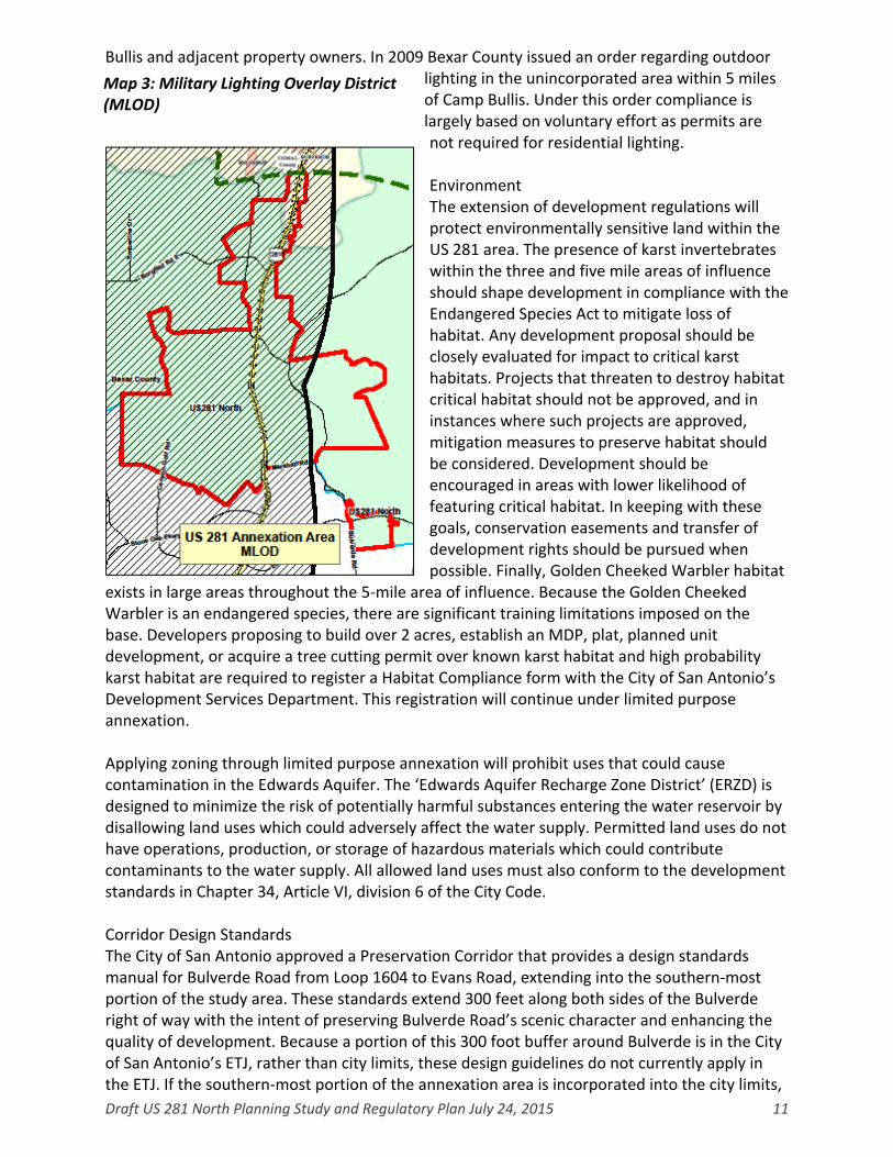
Draft US 281 North Planning Study and Regulatory Plan July 24, 2015 11
Bullis and adjacent property owners. In 2009 Bexar County issued an order regarding outdoor lighting in the unincorporated area within 5 miles of Camp Bullis. Under this order compliance is largely based on voluntary effort as permits are not required for residential lighting. Environment The extension of development regulations will protect environmentally sensitive land within the US 281 area. The presence of karst invertebrates within the three and five mile areas of influence should shape development in compliance with the Endangered Species Act to mitigate loss of habitat. Any development proposal should be closely evaluated for impact to critical karst habitats. Projects that threaten to destroy habitat critical habitat should not be approved, and in instances where such projects are approved, mitigation measures to preserve habitat should be considered. Development should be encouraged in areas with lower likelihood of featuring critical habitat. In keeping with these goals, conservation easements and transfer of development rights should be pursued when possible. Finally, Golden Cheeked Warbler habitat
exists in large areas throughout the 5‐mile area of influence. Because the Golden Cheeked Warbler is an endangered species, there are significant training limitations imposed on the base. Developers proposing to build over 2 acres, establish an MDP, plat, planned unit development, or acquire a tree cutting permit over known karst habitat and high probability karst habitat are required to register a Habitat Compliance form with the City of San Antonio’s Development Services Department. This registration will continue under limited purpose annexation. Applying zoning through limited purpose annexation will prohibit uses that could cause contamination in the Edwards Aquifer. The ‘Edwards Aquifer Recharge Zone District’ (ERZD) is designed to minimize the risk of potentially harmful substances entering the water reservoir by disallowing land uses which could adversely affect the water supply. Permitted land uses do not have operations, production, or storage of hazardous materials which could contribute contaminants to the water supply. All allowed land uses must also conform to the development standards in Chapter 34, Article VI, division 6 of the City Code. Corridor Design Standards The City of San Antonio approved a Preservation Corridor that provides a design standards manual for Bulverde Road from Loop 1604 to Evans Road, extending into the southern‐most portion of the study area. These standards extend 300 feet along both sides of the Bulverde right of way with the intent of preserving Bulverde Road’s scenic character and enhancing the quality of development. Because a portion of this 300 foot buffer around Bulverde is in the City of San Antonio’s ETJ, rather than city limits, these design guidelines do not currently apply in the ETJ. If the southern‐most portion of the annexation area is incorporated into the city limits,
Map 3: Military Lighting Overlay District (MLOD)

Draft US 281 North Planning Study and Regulatory Plan July 24, 2015 12
the extension of the 300 foot buffer is an opportunity to extend guidelines to enhance the quality of the built environment in a way that is compatible with the natural character of the area and residential development patterns. Given the expansion of the US 281 corridor and anticipated future commercial development, development fronting the roadway would benefit from a corridor overlay district similar to the Hill Country Gateway along IH‐10 West. Extending tools, such as zoning and development standards along the US 281 corridor and Bulverde Road will regulate the appearance of businesses along the roadway, protect public investments made to US 281, and preserve and enhance property values. Alamo Community College District The US 281 annexation area proposes to bring 36 parcels within Comal County into the City of San Antonio. It is important to distinguish that these residents will not be expected to contribute property taxes to the Alamo Community College District, however, should Comal County residents choose to enroll at Alamo Community College they will pay a premium over tuition for tax‐paying Bexar County residents. Agriculture and Agribusiness There are various agricultural parcels in the study area, with 25 percent of acres making up agricultural uses. Towards the north, there are some small‐scale farms and ranches. 44 parcels in the US 281 annexation study area are being offered development agreements given existing agricultural property valuations. For more information on these development agreements see the US 281 regulatory plan. Scenic, Cultural, and Historic Resource Protection The US 281 annexation area falls under the Edwards Plateau Texas Ecoregion. This ecoregion features multiple springs, stony hills and steep canyons, with rare plant and animal species found only in central Texas. The Edwards Plateau is comprised mostly of thin soil layers underlain with limestone, featuring thousands of caves. At the eastern edge of this ecoregion lies the Edwards Aquifer, a hidden world of underground lakes. Today the region is characterized by grasslands, juniper and oak woodlands, and plateau live oak or mesquite savannah. Elevation ranges from approximately 100 feet, to 3,000 feet above sea level, with several rivers cutting across the surface. Many residents choose to locate to the US 281 area for its scenic quality, with rolling hills and a rich tree canopy. As development continues, the extension of San Antonio’s city limits will allow the City to shape the character of future development, while offering residents the opportunity to engage in a public development process. Important archaeological and historical features in the US 281 annexation area include the Staudt House and Classen Ranch. The Staudt House is a representative example of 19th century German settlement in the San Antonio area. This class of historical Texas farm and ranch complex illustrates the use of indigenous building materials and the ethnic and cultural diversity of first phase settlements around present day San Antonio. The Classen Ranch, located at Canyon Springs Golf Club at Wilderness Oak is another example of 19th century German ranch settlements, and features an adjacent cemetery at the end of Wilderness Oak Road. These sites are both protected archaeological sites, as are two other cemeteries in the study area: Heinrich Voges along 281 in Comal County dating from 1895, the Leesch‐Vecker cemetery north of Borgeld Road, dating from 1860. In the interest of preserving historically significant sites the Office of Historic Preservation performs reviews prior to the issuance of approval for new

Draft US 281 North Planning Study and Regulatory Plan July 24, 2015 13
Master Development Plans, and in general different archaeological documentation may be required based on the type of private development project and location. The application of historic landmark and district designations through zoning offers protections that require development projects meet standards for the exterior rehabilitation of historic properties and appropriate site design by review of a Historic Design Review Commission. Presently, counties are unable to offer these protections related to local landmarks and districts. Tributaries of the Mud Creek flow through the US 281 Annexation area. Mustang Creek, Borgfeld Creek, Elm Waterhole Creek, and West Fork Creek also run through the study area. Cibolo Creek forms the boundary between Bexar and Comal Counties and flows through the top portion of the study area. See inset map for illustration of the 100 year floodplain. Between all land use categories, 860 acres, or 11% of the US 281 annexation area lie in the 100 year floodplain. The extension of zoning and development codes to the area will prevent uses that could have negative impacts to surface water resources and prevent unauthorized uses and
construction within the floodplain; thereby, improving water quality, riparian habitat, and public safety. There is potential that some of the vacant, natural floodplain surrounding MDPs in the watersheds discussed above could provide opportunities for conservation easements for both active and passive recreation opportunities like those found in San Antonio’s urban core. The existing Mud Creek Trail Park, east of US 281 within Loop 1604 to the south of the annexation study area is one such example. Stone Oak Park, Panther Spring Park, and Gold Canyon Park are other large scale parks just to the south of the study area within city limits. Other area outdoor amenities include eight full‐size, private, lighted soccer fields at the northern boundary of the 281 annexation area, at 29064 Bulverde Road. These are operated and managed as a party of the broader GVTC Communications Sportsplex. In addition the
private luxury TPC golf course is located just outside the study area on the Lumbermen’s Investment Corporation non‐annexation agreement land. Canyon Springs Golf Club on the western boundary of the annexation study area is a less exclusive, also private golf course surrounding the Links at Canyon Springs subdivision. Natural areas and golf courses that are annexed will be zoned so they can continue to operate as open space and recreational amenities. Proposed Zoning for the Area The zoning plan was developed based on the future land use plan for the area, and current land uses identified through Bexar County Appraisal District data, aerial maps, and field surveys. The area will be zoned in accordance with the procedures required by state law and the Unified Development Code (UDC), Chapter 35 of the City Code of Ordinances.
Map 4: Creeks and Floodplain

Draft US 281 North Planning Study and Regulatory Plan July 24, 2015 14
The proposed zoning for the annexation
area includes a range of uses based on the future land use patterns developed in the North Sector Plan. Annexation will encourage the establishment of a commercial corridor and nodal development around a future regional center in an effort to mitigate congestion and preserve regional character. As a consequence of the proximity of the annexation area to Camp Bullis, roughly 5,634 acres are covered by the Military Lighting Overlay District (MLOD‐1) in an effort to mitigate interference from lighting on Camp Bullis missions. In addition, a significant proportion of the US 281 annexation area covers the Edwards Aquifer recharge zone, and as a result has been assigned the Edwards Aquifer Recharge Zone (ERZD) overlay to shape the character over the aquifer.
The City of San Antonio approved a Preservation Corridor (PC‐1) that provides a design standards manual for Bulverde Road from Loop 1604 to Evans Road, extending into the southern‐most portion of the study area. These standards extend 300 feet along both sides of the Bulverde right of way with the intent of preserving Bulverde Road’s scenic character and enhancing the quality of development. Because a portion of this 300 foot buffer around Bulverde Road is in the City of San Antonio’s ETJ, rather than city limits, these design guidelines do not currently apply in the ETJ. If the southern‐most portion of the annexation area is incorporated into the city limits, the extension of the 300 foot buffer is an opportunity to extend guidelines to enhance the quality of the built environment in a way that is compatible with the natural character of the area and residential development patterns. A similar overlay has been proposed as a Gateway Corridor District (GC‐3) at a width of 1,000 feet along U.S. 281. The Department of Planning and Community Development would use a Gateway Corridor as a tool to enhance and shape the
Map 5: Proposed MLOD
Map 6: Proposed ERZD

Draft US 281 North Planning Study and Regulatory Plan July 24, 2015 15
built environment along this highway as conditions are likely to change dramatically with the expansion of the roadway. As the annexation area continues to develop land use, zoning, and overlay districts all stand to play a critical role in retaining the character that has made these areas so appealing to new and longtime residents.
The proposed base zoning for the annexation area is detailed on the map below. To determine the proposed zoning for a parcel, consult the City of San Antonio Planning and Community Development Department’s Proposed Annexation interactive map at: http://www.sanantonio.gov/Planning/PlanningUrbanDesign/Annexation/AnnexationProgram.aspx
Notice to property owners and by publication, public hearing or hearings and recommendation by the zoning commission shall be followed, and further, notice shall be mailed to adjacent property owners, both inside and outside the corporate limits of the city, whose property is within two hundred (200) feet of the subject property. Comments regarding the proposed zoning will be considered at the public hearings held by the Zoning Commission and City Council.
Map 7: Proposed GC‐3 and PC‐1 Corridor Overlay Districts

Draft US 281 North Planning Study and Regulatory Plan July 24, 2015 16
Map 8: Proposed Base Zoning

Draft US 281 North Planning Study and Regulatory Plan July 24, 2015 17
CITY OF SAN ANTONIO LIMITED PURPOSE ANNEXATION REGULATORY PLAN for
US 281 NORTH This section constitutes the regulatory plan, prepared in accordance with §43.123 (d) of the Local Government Code. The regulatory plan identifies:
Land Use and Development Regulations
Future Full Purpose Annexation. Land Use Existing Land Use The US 281 annexation area consists of 7,612 acres outside of Loop 1604. The annexation area is comprised largely of single‐family residential subdivisions, commercial development along the US 281 corridor, and various agricultural and vacant uses. Significant commercial growth is anticipated along the US 281 corridor as the Texas Department of Transportation undertakes a highway expansion project to accommodate traffic. Map 1: Bexar County Appraisal District Existing Land Use1
Comprehensive Plan and Future Land Use The 2010 North Sector Plan is a component of the Comprehensive Master Plan of the City of San Antonio. In an effort to guide the character of development the North Sector Plan set future land use guidelines for the US 281 annexation area. This plan document currently
1 Based on 2014 Bexar Appraisal District Data.
Existing Land Use
Acreage Percentage
Single Family
3488.91 57.5
Multi‐Family 77.25 1.3
Vacant Land 861.47 14.2
Farm and Ranch
964.83 15.9
Commercial 646.55 10.6
Industrial 9.68 .2
Utility 5.89 .2
Exempt 17.79 .3
Total 6072.37 100
Flood Plain 860.00 11%
Draft US 281 North Planning Study and Regulatory Plan July 24, 2015 18
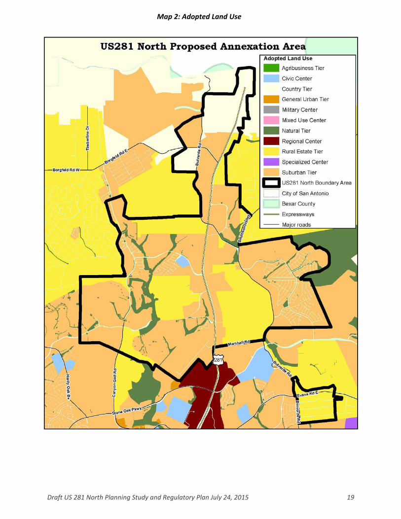
satisfies the requirements of §43.127 (b) of the Local Government Code as a land use and intensity plan and will continue to serve as a basis for services and capital improvement project planning. Thereafter, suitable zoning districts will be recommended for the area based on the amended plan. (See the Planning Study for information regarding the proposed zoning.) The North Sector Plan has designated the highest density residential and commercial uses in Regional Center, Suburban Tier, and Civic Center future land use designations. These uses are found along highways, major roadways and nodes located at several major intersections. Based on existing conditions and the rapid rate of growth in this area, the Department of Planning and Community Development will establish General Urban Tier land use in areas of dense multi‐family development. Lower density residential and commercial uses are designated in the Rural Estate Tier (> .5 acre lots), Country Tier (> 10 acre lots) and Natural Tier near floodplains and natural areas. Most development in the US 281 area is characterized by MDPs at differing levels of completion. Undeveloped MDPs fall primarily within the Suburban and Rural Estate Tier lower intensity residential land use categories. Floodplains exist in the Natural Tier Land Use category. The Adopted Land Use is depicted in the following map:
Draft US 281 North Planning Study and Regulatory Plan July 24, 2015 19
Map 2: Adopted Land Use

Draft US 281 North Planning Study and Regulatory Plan July 24, 2015 20
Proposed Land Use If a future land use amendment is required, the proposed amendment from the adopted future land use category to the proposed future land use category must be consistent with the City’s Comprehensive Plan. The City’s long range goals referenced on the Limited Purpose Annexation Planning Study for US 281 North (p. 8) were considered in developing the future land use plan. Additionally, the proposed future land use categories are complimentary to the existing land uses and future land use classifications throughout the annexation area. Several amendments to the North Sector Plan are proposed for the annexation area in keeping with current uses and expected growth. The most significant proposed changes are the expansion of the Suburban Tier land use category along US 281, and the creation of two Regional Center Land Use nodes. In Comal County, where current incompatible land uses exist side by side, proposed land use standardizes uses and establishes a node of Agribusiness Tier uses. The future land use plan amendments for the annexation area are detailed on the following map. To determine the proposed land use for a parcel, consult the City of San Antonio Planning and Community Development Department’s Proposed Annexation interactive map at: http://www.sanantonio.gov/Planning/PlanningUrbanDesign/Annexation/AnnexationProgram.aspx

Draft US 281 North Planning Study and Regulatory Plan July 24, 2015 21
Map 3: Proposed Land Use

Draft US 281 North Planning Study and Regulatory Plan July 24, 2015 22
Development Regulations The following planning, zoning, health and safety ordinances in the San Antonio, Texas, Code of Ordinances will be enforced in the areas upon completion of annexation for limited purposes:
Chapter 6 – Buildings Chapter 10 – Building Related Codes Articles II, III and IV of Chapter 11‐ Fire Prevention including references to Chapter 16 (Licenses and Business Regulations) pertaining to Hazardous Materials Permits
Article VII‐Used Automotive Parts Recyclers and Metal Recycling Entities of Chapter 16‐ Licenses and Business Regulations
Chapter 28‐Signs Chapter 34‐Water and Sewers
Chapter 35 – Unified Development Code, including, but not limited to, zoning regulations and all subsequent amendments, replacement ordinances, and related technical and illustrative manuals to these ordinances.
Notwithstanding the Municipal Code references above, the following exceptions shall be established if this area is annexed for limited purposes:
Fees will be waived for a 180 day period for property owners seeking to register existing uses as non‐conforming rights, to rezone a property, or to apply for a plan amendment associated with a proposed rezoning of a property.
Excluding services and fees for Drainage Utility Services authorized by the Texas Local Government Code, Section 552.044(4)(A) and adopted in Chapter 34 – Water and Sewers
Both the City of San Antonio and Bexar County will have dual review and will assess fees for subdivision plats in the Limited Purpose Annexation area in accordance with the procedures within the ETJ as outlined in the most recently executed Inter Local Agreement (ILA) between the City of San Antonio and Bexar County.
Bexar County will continue its procedures for streetlights (35‐506.i), continue the maintenance and acceptance of streets and drains and continue to use its own requirements and procedures for pavement design in the Limited Purpose Annexation area as outlined in the most recent ILA. Right‐of‐way permits and flood development permits will continue to be the responsibility of Bexar County during Limited Purpose Annexation.
Property owners will be allowed to erect, maintain, and repair traditional barbed wire or electric fences used in conjunction with agricultural, farming or ranching operations.
Property owners within the limited purpose annexation area will be allowed 180 days to bring their property into compliance with City Codes.
Future Full Purpose Annexation The areas subject to this Limited Purpose Annexation will be included within the City’s full purpose jurisdiction within three (3) years of the effective date of the limited purpose annexation ordinance unless the date for full purpose annexation is postponed by written agreement between the City and a majority of the affected landowners of a tract of land.

Draft US 281 North Planning Study and Regulatory Plan July 24, 2015 23
Planning Milestones State law requires specific steps be completed by the City for each of the three years after an area is annexed for limited purposes leading toward the full‐purpose annexation of the areas.
By the end of the first year, the City must prepare a land use and intensity plan to be a basis for services and capital improvement project (CIP) planning.
By the end of the second year, the City must include the area in the long‐range financial forecast and in the City’s program to identify future CIP projects.
By the end of the third year, the City must include CIP projects intended to serve the area in the adopted CIP program and identify potential sources of funding.
Development Agreement Pursuant to Section 43.035 of the Local Government Code, the City of San Antonio is obligated to offer a Development Agreement to properties appraised for ad valorem tax purposes as agricultural, wildlife management, or timber management. The properties that will be offered a Development Agreement are depicted on the map below.
Disclaimers The City has made a good‐faith effort to provide accurate references to the Municipal Code sections in which the ordinances described above are codified. In the event that a portion of the Municipal Code listed above contains a reference to a portion of the Municipal Code or another City Ordinance that is not listed above then, to the extent necessary to either provide meaning to or to carry out the meaning of the listed portions, the referenced portions of the Local Government Code, Municipal Code or other City Ordinances shall also apply. Any failure to list all relevant Municipal Code references is inadvertent and will not affect enforcement of the ordinances by the City. Further, any and all exhibits contained herein are intended for reference purposes only and shall not be construed to be final. All exhibits shall be
deemed “final” upon adoption of this draft Limited Purpose Annexation proposal. The adopted regulatory plan must be the same as the proposed regulatory plan unless the San Antonio City Council finds and states in the ordinance the reasons for adoption of a different regulatory plan. The City of San Antonio City Council, by ordinance, may change an adopted regulatory plan if, in the ordinance making the change, the City Council finds and states the reasons for the adoption of the change.
Map 4: Properties with Agricultural Valuations