city planning using integrated urban modelling€¦ · city planning using integrated urban...
TRANSCRIPT
Proceedings of the 11th Space Syntax Symposium
CITY PLANNING USING INTEGRATED URBAN MODELLINGJeddah Structure Plan 37.1
ABHIMANYU ACHARYASpace Syntax [email protected]
KAYVAN KARIMI Space Syntax [email protected]
ED PARHAM Space Syntax [email protected]
ATAKAN GUVENSpace Syntax [email protected]
GÖZDE UYARSpace Syntax [email protected]
#37CITY PLANNING USING INTEGRATED URBAN MODELLINGJeddah Structure Plan
ABSTRACT
This paper explores the use of weighted space syntax models to contribute to the process of integrated urban planning for Jeddah as part of a major planning project in the Saudi Arabia. The Municipality of Jeddah commissioned the production of an integrated suite of planning documents. These plans coordinate Strategic, Sub-Regional, Structural and Local plans across a citywide region and aim to provide a framework for sustainable urban growth and development over the next 20 years. This paper focuses on the space syntax methodologies used to aid urban planners to develop the Structure Plan and builds on the research used to develop the Sub-Regional Plan (Karimi et al, 2015). The Structure Plan studied how the urban structure of the city could accommodate the growth of population by about three million over the next 20 years. This included developing and testing a centres strategy to distribute population, employment and supporting facilities along with a public transport strategy for the city. For analysing the potential and requirements of the city, an Integrated Urban Model (IUM) was constructed to combine the spatial network with land use, population, employment and public transport. The aim of this model was to test the impact of changes in the distribution of population and employment. It also allowed the assessment of public transport alignments. The IUM is a key design tool for planning and optimising the relationships between population, employment and public transport. It was also used to provide a benchmarking methodology to compare options. Because the model links people to employment using the spatial network and public transport, the performance of options can be expressed in terms of benefits to the city’s population.
Proceedings of the 11th Space Syntax Symposium
CITY PLANNING USING INTEGRATED URBAN MODELLINGJeddah Structure Plan 37.2
KEYWORDS
Integrated urban model, Design option testing, Centre hierarchies, Public transport strategy
1.INTRODUCTION
This paper aims to establish the capability of space syntax models to inform the planning process at a metropolitan scale. The paper investigates the applicability of an Integrated Urban Model (IUM) in the planning process for large cities rather than finding correlations between the spatial network measures and socio-economic phenomena. The study described in this paper is part of planning projects undertaken over the past three years to produce a growth strategy for Jeddah, Saudi Arabia (AECOM, 2014).
The project aimed to develop the Structure plan for Jeddah working with AECOM, an international multi-disciplinary planning consultancy. The Structure plan was based on outcomes established in the Strategic and Sub-regional plans which were developed prior to this project. Space Syntax Limited have already contributed to the development of the previous stages focussing on regional growth strategy, through advanced space syntax models and analysis (Karimi, Parham, Fridrisch, & Ferguson, 2013; Karimi & Parham, 2012, Karimi et al, 2015). The Structure Plan aimed to define distributions of population and employment at a fine scale (groupings of circa 60,000 residents), propose locations for centres (using the hierarchies defined in the Strategic Plan), develop the supporting urban systems and a public transport strategy (Karimi et al, 2015, AECOM, 2015).
Previously, large-scale space syntax models have been used to identify the key spatial characteristics of cities (Hillier & Penn, 1996; Hillier, 1996, 2001; Penn, Hillier, Banister, & Xu, 1998). These studies recognised a strong relationship between vehicular movement, distribution of land use, centre hierarchies with space syntax measures, such as ‘Choice’ (betweenness) and ‘Integration’ (closeness). These strong relationships have suggested that space syntax analysis could be used as an explorative model to understand large spatial systems better and also inform the processes of urban planning and design (Hillier & Stonor, 2010; Karimi, 2012; Penn, 2008).
However, a standard space syntax model, which only analyses the spatial system based on its geometric configuration lacks the ability to highlight the nuances of a rapidly developing city like Jeddah. The existing measures also lack the ability to test the impact of proposed changes which do not involve the change of the spatial network like a change in the distribution of densities and jobs. The model also struggles to test the impact of proposed developments where data regarding the proposed spatial structure is not available.
The Integrated Urban Model (IUM) was developed to respond to these issues. The IUM is a weighted spaces syntax model which combines the spatial model of the city with other data sets like land use and public transport systems. The IUM can assess the combined impact of proposals, and inform the development of individual urban components or systems.
This paper investigates how space syntax models can be enhanced by combining the spatial model with various other datasets to create an IUM; and secondly, explores how an IUM can help planning processes like the distributing density at a fine scale, designing a hierarchy of centres and developing supporting urban systems like public transport.
The questions this paper will explore are -
• How can urban datasets (population, employment and public transport) be combined with space syntax spatial models to create an IUM?
• How can an IUM test the impact of changes to land use on activity and movement patterns of Jeddah?
• How can an IUM communicate results in a form easily understood by architects, planners and clients?
• How can an IUM assess the impact of different urban elements simultaneously rather than in silos?
Proceedings of the 11th Space Syntax Symposium
CITY PLANNING USING INTEGRATED URBAN MODELLINGJeddah Structure Plan 37.3
1.1 CONTEXT
The study is based in Jeddah, Saudi Arabia. Jeddah is a major port located on the eastern coast of the Red Sea and is fast becoming a regional economic centre. It remained a traditional Arabian city till 1950 with a population of around 35,000, living within the walled city (Daghistani, 1993). Since then the city has grown massively and the region now has a population about 3.6 million and is predicted to reach an estimated population of 6 million in 2033 (Daghistani, 1993, AECOM, 2013, 2014, 2015). The uncontrolled growth post-1950 has left the city with an extensive, poorly focused structure. This urban condition has resulted in dependence on car travel, overcrowded roads; and service infrastructure, which does not reach all citizens (El-Shafie, 2010). The overarching aim of the Structure Plan was to address the existing urban condition and ensure that urban growth can be effectively managed over time in a sustainable way.
Hillier (2009) defines ‘spatial sustainability’, through the geometry and configurational ordering of spaces in a city. The generic form of a city is defined as a foreground network of streets, centres and sub centres across scales set in a mainly residential background network. This arrangement is a by-product of the micro socio-economic forces acting on the city. This combined with the process of minimising travel time by increasing accessibility between different spaces in a city results in a self-organised sustainable spatial system (Hillier, 2009). The foreground network is shaped by microeconomic forces representing the invariable patterns found in all cities, while the background network, defined by the socio-cultural forces varies depending on the cultural and social practices prevalent in the city. The balance between the microeconomic and socio-cultural forces define the spatial growth of a city (Hillier, 2002). The spatial configuration of the street network generates movement and results in some streets being preferred as routes and destinations in the city (Hillier, Penn, Hanson, Grajewski & Xu, 1993). Hillier et al (1993) argue that high footfall-dependent functions, such as retail, locate themselves on streets with a high potential for natural movement, while streets with a lower movement attract land uses like residential, which seek low movement. In addition, functions like retail and commerce attract even more movement, contributing to the inherent high movement potential of the street. This cyclic process results in such streets or centres acting both as routes and destinations (Griffiths, Vaughan, Haklay & Jones, 2008). These patterns are found universally in most cities (Hillier, 2002).
However, these patterns are not observed in Jeddah. The growth pattern of Jeddah and other cities in the developing world have shown similar trends to the New Towns in the UK, with mono-functional land use zones, inward facing urban blocks and a motorway dominated movement network (Karimi, 2009). These trends coupled with a disregard for the existing organic spatial structure while planning has caused deterioration of parts of Jeddah and led to unorganised urban growth (Bahaydar, 2013).
Jeddah has no consistent centres hierarchy across the city, with the spatial hierarchy, activity centres fragmented across the urban area. This is compounded by the sporadic nature of planned development with major projects often permitted in isolated locations. The city structure is characterised by linear form, resultant of a dominant foreground structure as the road structure was designed to enhance vehicular travel. People have to travel significant distances to access their daily needs and employment destinations. The city’s growth is the major contributor to this condition. Small scale, high density, a walkable urban form developed organically until the 1970s was replaced by low-density, vehicle-scale, sub-divisions and unintelligible street networks. Local scale commercial centres are found in the older, denser areas (unplanned settlements). The planned parts of the city contain almost no local Centres. Larger commercial centres are formed by long, linear strip development alongside highways infrastructure. With commercial uses spread along road frontages, activity is spread out and diluted, resulting in very few nodes of commercial activity. This urban development pattern coupled with the hot and humid climatic conditions is not conducive to walking given the length of these commercial centres. (Karimi, Parham, Fridrisch, & Ferguson, 2013; Karimi & Parham, 2012, Karimi et al, 2015, AECOM, 2014).
Proceedings of the 11th Space Syntax Symposium
CITY PLANNING USING INTEGRATED URBAN MODELLINGJeddah Structure Plan 37.4
2. DATASETS AND METHODS
2.1. INTEGRATED URBAN MODEL
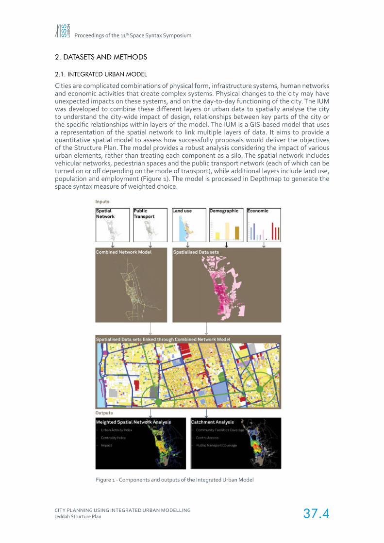
Cities are complicated combinations of physical form, infrastructure systems, human networks and economic activities that create complex systems. Physical changes to the city may have unexpected impacts on these systems, and on the day-to-day functioning of the city. The IUM was developed to combine these different layers or urban data to spatially analyse the city to understand the city-wide impact of design, relationships between key parts of the city or the specific relationships within layers of the model. The IUM is a GIS-based model that uses a representation of the spatial network to link multiple layers of data. It aims to provide a quantitative spatial model to assess how successfully proposals would deliver the objectives of the Structure Plan. The model provides a robust analysis considering the impact of various urban elements, rather than treating each component as a silo. The spatial network includes vehicular networks, pedestrian spaces and the public transport network (each of which can be turned on or off depending on the mode of transport), while additional layers include land use, population and employment (Figure 1). The model is processed in Depthmap to generate the space syntax measure of weighted choice.
Figure 1 - Components and outputs of the Integrated Urban Model
Proceedings of the 11th Space Syntax Symposium
CITY PLANNING USING INTEGRATED URBAN MODELLINGJeddah Structure Plan 37.5
2.1.1 SPATIAL NETWORK
The spatial network uses a space syntax model of the city as a base. These models have been created for the existing city and multiple proposal options. The motorway interchanges and multi-lane highways were consistently simplified to the fewest possible lines. Spaces have been categorised according to those which are accessible only to vehicles, those which are accessible to vehicles and pedestrians and those which are accessible only to pedestrians. This allows analysis to be carried out using any combination of these networks. To carry out catchment analysis and characterise the public realm, the vehicular network has had peak-time average speeds assigned in relation to their allocated hierarchy. Peak traffic speeds have been estimated using survey data on existing average journey speeds. The following speeds are the result of this process:
• Metro 90 km/h
• Highways 50 km/h
• Strategic/Arterial Routes 50 km/h
• Collector/Distributors 45 km/h
• Local Roads 35 km/h
• Pedestrian Only Routes 5km/h
2.1.2 PUBLIC TRANSPORT
The public transport network represented in a different way to the spatial network. When moving across a city, the use of public transport is based on a different type of way-finding decision to moving on foot or by car. The direct connection between stations is more important than identifying the easiest route through the street network. As a result, public transport is represented as a topological set of links that may not follow the street network but which link proposed station locations. As with the spatial network, typical speeds have been assigned to the public transport network which enables it to be included in any catchment or coverage analysis. The average speeds associated with each mode of public transport are:
• High-Speed Rail 50 km/h
• Commuter Rail 40 km/h
• Mass Rail Transit 30 km/h
• Light Rail Transit 15 km/h
2.1.3 LAND USE
Land use data was provided in GIS format. Data was combined from several surveys at the plot level:
• Qattan survey (2007)
• ZFP Unplanned Settlements survey (2004)
• ZFP Wider city survey (2004)
Data from each survey required work to become consistent with a set of overall and detailed uses. The GIS tables had varying data structures, land use distribution and overlapping data which was merged into one combined dataset. Where survey data was contradictory or unavailable but development could be seen in aerial satellite photography, missing plots were added to the GIS dataset. Land use was allocated to these blocks either based on correspondence with colleagues in Jeddah or information available online. Preliminary checks on the accuracy of land use data were made through the processes of distributing population and employment and the inaccuracies were corrected where necessary.
Proceedings of the 11th Space Syntax Symposium
CITY PLANNING USING INTEGRATED URBAN MODELLINGJeddah Structure Plan 37.6
The plots were divided under the following land uses
1. Low-Density Residential - Villas
2. High-Density Residential - Apartments
3. Unplanned Housing
4. Offices
5. Retail
6. Shopping Malls
7. Hotels
8. Light Industry
9. Heavy Industry
10. PowerStation/Refinery
11. Port
12. Warehouses
13. Educational services
14. Health Services
15. Religious services
16. Government
2.2 SPATIALISING DATA
Each data set combined in the model had a different origin format: the spatial model focused on street segments between junctions, land use data was available at the plot level across most of the city, while non-spatial demographic and economic data was available at the level of the city and the employment sector.
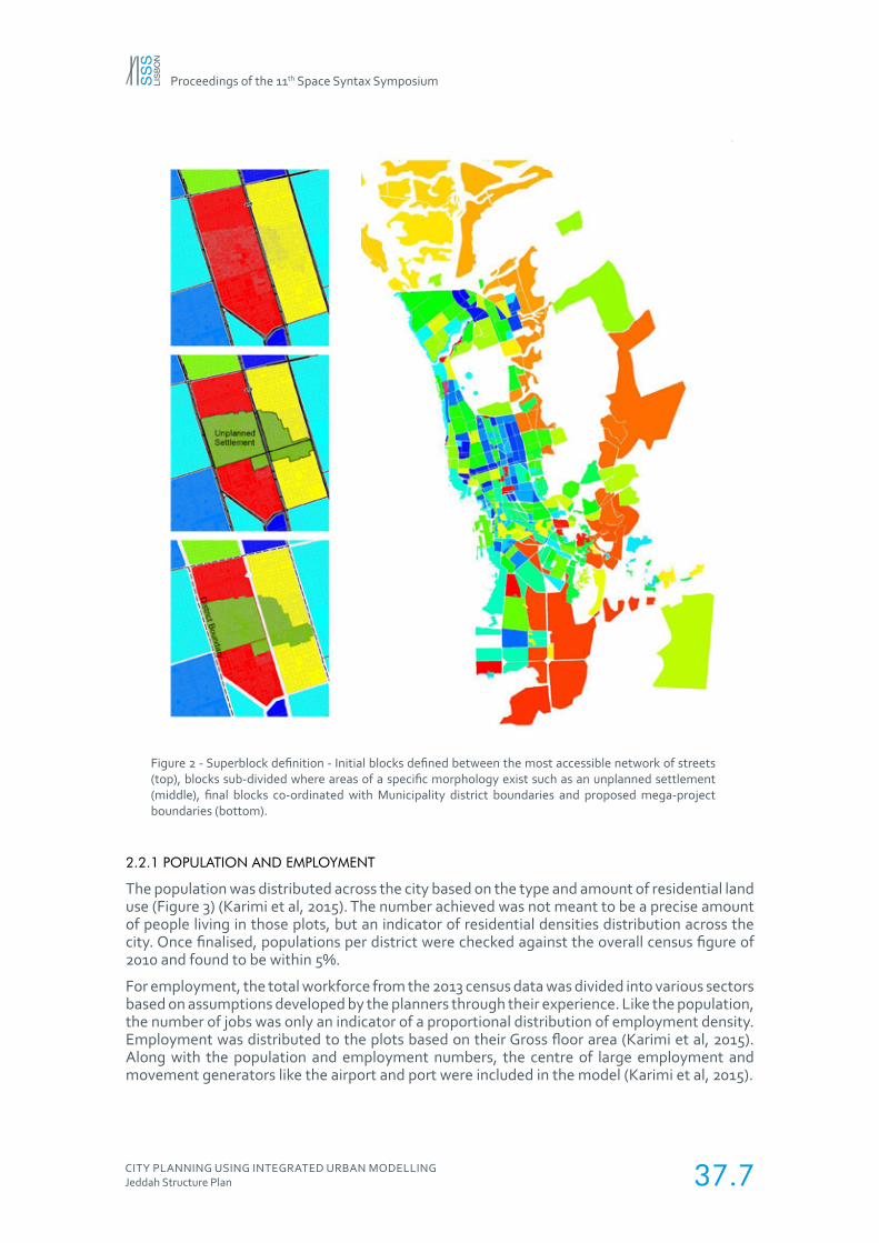
One of the key roles of the IUM is to spatialise data sets from different sources and combine them. To do this requires a consistently defined spatial element. A series of regions called “superblocks” were defined within the city and used to distribute non-spatial data, and to aggregate plot level and street segment data (Figure 2). The following urban elements were used to define superblocks:
1. Major routes or the foreground network defined by Global Normalised Choice value above 1.3 (Karimi et al, 2015).
2. Significant changes to morphology occur like the unplanned settlements or large single use plots (Figure 2).
3. Existing municipal district boundaries.
4. Mega projects being built or to be built by 2033.
The motorways and highways, which are the longest street segments, were not included within the superblocks boundaries and no weightings were applied to them. This was due to the fact that it would not be possible to access any land use from the motorways and thus they would not generate or attract any movement by themselves and only act as routes (Karimi et al, 2015).
Proceedings of the 11th Space Syntax Symposium
CITY PLANNING USING INTEGRATED URBAN MODELLINGJeddah Structure Plan 37.7
Figure 2 - Superblock definition - Initial blocks defined between the most accessible network of streets (top), blocks sub-divided where areas of a specific morphology exist such as an unplanned settlement (middle), final blocks co-ordinated with Municipality district boundaries and proposed mega-project boundaries (bottom).
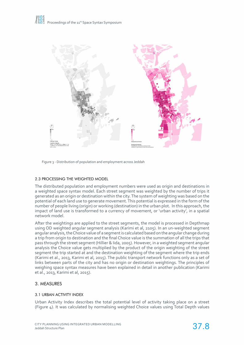
2.2.1 POPULATION AND EMPLOYMENT
The population was distributed across the city based on the type and amount of residential land use (Figure 3) (Karimi et al, 2015). The number achieved was not meant to be a precise amount of people living in those plots, but an indicator of residential densities distribution across the city. Once finalised, populations per district were checked against the overall census figure of 2010 and found to be within 5%.
For employment, the total workforce from the 2013 census data was divided into various sectors based on assumptions developed by the planners through their experience. Like the population, the number of jobs was only an indicator of a proportional distribution of employment density. Employment was distributed to the plots based on their Gross floor area (Karimi et al, 2015).Along with the population and employment numbers, the centre of large employment and movement generators like the airport and port were included in the model (Karimi et al, 2015).
Proceedings of the 11th Space Syntax Symposium
CITY PLANNING USING INTEGRATED URBAN MODELLINGJeddah Structure Plan 37.8
Figure 3 - Distribution of population and employment across Jeddah
2.3 PROCESSING THE WEIGHTED MODEL
The distributed population and employment numbers were used as origin and destinations in a weighted space syntax model. Each street segment was weighted by the number of trips it generated as an origin or destination within the city. The system of weighting was based on the potential of each land use to generate movement. This potential is expressed in the form of the number of people living (origin) or working (destination) in the urban plot. In this approach, the impact of land use is transformed to a currency of movement, or ‘urban activity’, in a spatial network model.
After the weightings are applied to the street segments, the model is processed in Depthmap using OD weighted angular segment analysis (Karimi et al, 2105). In an un-weighted segment angular analysis, the Choice value of a segment is calculated based on the angular change during a trip from origin to destination and the final Choice value is the summation of all the trips that pass through the street segment (Hillier & Iida, 2005). However, in a weighted segment angular analysis the Choice value gets multiplied by the product of the origin weighting of the street segment the trip started at and the destination weighting of the segment where the trip ends (Karimi et al., 2013, Karimi et al, 2015). The public transport network functions only as a set of links between parts of the city and has no origin or destination weightings. The principles of weighing space syntax measures have been explained in detail in another publication (Karimi et al., 2013, Karimi et al, 2015).
3. MEASURES
3.1 URBAN ACTIVITY INDEX
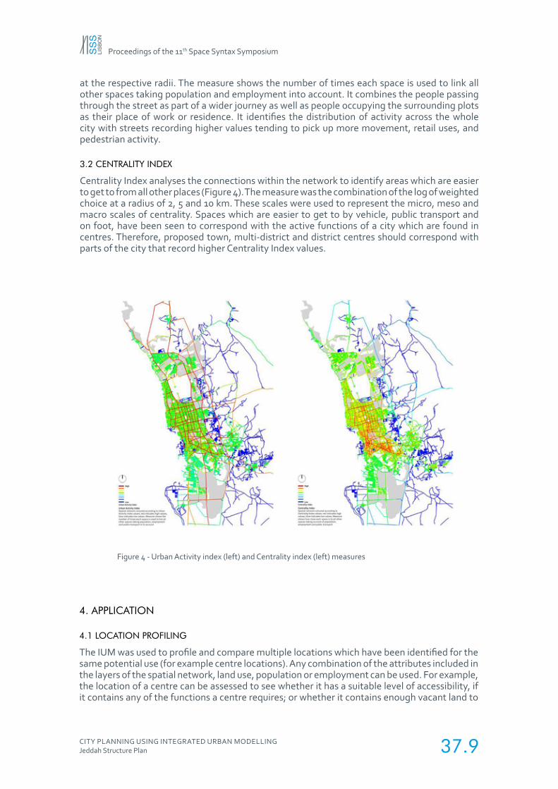
Urban Activity Index describes the total potential level of activity taking place on a street (Figure 4). It was calculated by normalising weighted Choice values using Total Depth values
Proceedings of the 11th Space Syntax Symposium
CITY PLANNING USING INTEGRATED URBAN MODELLINGJeddah Structure Plan 37.9
at the respective radii. The measure shows the number of times each space is used to link all other spaces taking population and employment into account. It combines the people passing through the street as part of a wider journey as well as people occupying the surrounding plots as their place of work or residence. It identifies the distribution of activity across the whole city with streets recording higher values tending to pick up more movement, retail uses, and pedestrian activity.
3.2 CENTRALITY INDEX
Centrality Index analyses the connections within the network to identify areas which are easier to get to from all other places (Figure 4). The measure was the combination of the log of weighted choice at a radius of 2, 5 and 10 km. These scales were used to represent the micro, meso and macro scales of centrality. Spaces which are easier to get to by vehicle, public transport and on foot, have been seen to correspond with the active functions of a city which are found in centres. Therefore, proposed town, multi-district and district centres should correspond with parts of the city that record higher Centrality Index values.
Figure 4 - Urban Activity index (left) and Centrality index (left) measures
4. APPLICATION
4.1 LOCATION PROFILING
The IUM was used to profile and compare multiple locations which have been identified for the same potential use (for example centre locations). Any combination of the attributes included in the layers of the spatial network, land use, population or employment can be used. For example, the location of a centre can be assessed to see whether it has a suitable level of accessibility, if it contains any of the functions a centre requires; or whether it contains enough vacant land to
Proceedings of the 11th Space Syntax Symposium
CITY PLANNING USING INTEGRATED URBAN MODELLINGJeddah Structure Plan 37.10
accommodate new uses. Potential multi-district and district centre locations were assessed in terms of accessibility, whether they already have any of the facilities required for that category of the centre within 400m, and how much vacant land is within 400m.
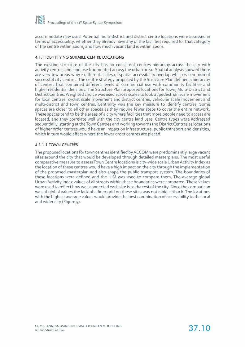
4.1.1 IDENTIFYING SUITABLE CENTRE LOCATIONS
The existing structure of the city has no consistent centres hierarchy across the city with activity centres and land use fragmented across the urban area. Spatial analysis showed there are very few areas where different scales of spatial accessibility overlap which is common of successful city centres. The centre strategy proposed by the Structure Plan defined a hierarchy of centres that combined different levels of commercial use with community facilities and higher residential densities. The Structure Plan proposed locations for Town, Multi-District and District Centres. Weighted choice was used across scales to look at pedestrian scale movement for local centres, cyclist scale movement and district centres, vehicular scale movement and multi-district and town centres. Centrality was the key measure to identify centres. Some spaces are closer to all other spaces as they require fewer steps to cover the entire network. These spaces tend to be the areas of a city where facilities that more people need to access are located, and they correlate well with the city centre land uses. Centre types were addressed sequentially, starting at the Town Centres and working towards the District Centres as locations of higher order centres would have an impact on infrastructure, public transport and densities, which in turn would affect where the lower order centres are placed.
4.1.1.1 TOWN CENTRES
The proposed locations for town centres identified by AECOM were predominantly large vacant sites around the city that would be developed through detailed masterplans. The most useful comparative measure to assess Town Centre locations is city-wide scale Urban Activity Index as the location of these centres would have a high impact on the city through the implementation of the proposed masterplan and also shape the public transport system. The boundaries of these locations were defined and the IUM was used to compare them. The average global Urban Activity Index values of all streets within these boundaries were compared. These values were used to reflect how well connected each site is to the rest of the city. Since the comparison was of global values the lack of a finer grid on these sites was not a big setback. The locations with the highest average values would provide the best combination of accessibility to the local and wider city (Figure 5).
Proceedings of the 11th Space Syntax Symposium
CITY PLANNING USING INTEGRATED URBAN MODELLINGJeddah Structure Plan 37.11
Figure 5 - Process of identifying and testing location of centres across hierarchies

Proceedings of the 11th Space Syntax Symposium
CITY PLANNING USING INTEGRATED URBAN MODELLINGJeddah Structure Plan 37.12
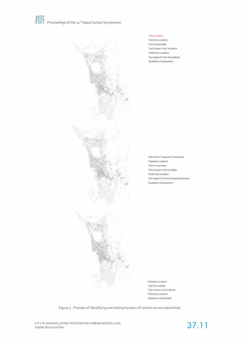
4.1.1.2 MULTI-DISTRICT AND DISTRICT CENTRES
Once the Town Centre locations were identified, major public transport alignments were identified to best link then together. These alignments influenced the ultimate routes, interchanges and modes proposed in the accompanying transport plan and also had a subsequent influence on the location of both Multi-District and District centres.
The role of Multi-District Centres and District Centres was to serve multiple “superblocks”. Thus the potential locations that covered superblocks most efficiently were located at the intersection of ‘superblocks’. These intersections were represented as a series of points in the network.
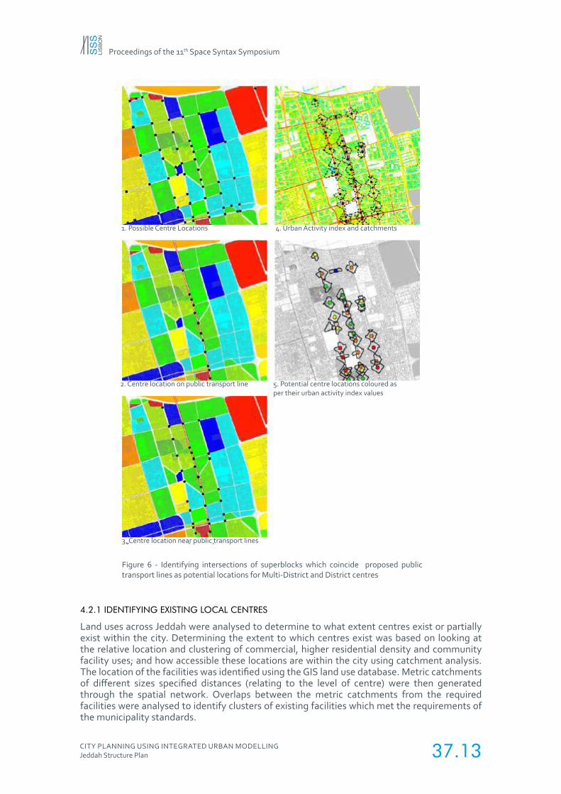
Multi-District Centres should be located in the strongest location close to the intersections of public transport lines. They were identified by plotting proposed public transport alignments and identifying the intersections between superblocks that coincided with the intersections between public transport alignments. District Centres should be located in the strongest locations along public transport alignments and were identified by plotting the intersections of the superblocks with proposed public transport alignments. To provide alternative locations, potential sites were extended to include the points where immediately adjacent superblocks meet (Figure 6).
Multi-District Centres and District Centres need to be accessible to the wider city, but also to local pedestrian and cycle scale movement. As Multi-District Centres and District Centres are smaller and will make less change, more of the existing street network will be retained. Locating these Centres requires an understanding of the existing network. To understand how these scales of access work together at each point, Urban Activity Index values were combined to include pedestrian, cycle, city-wide scale (using the vehicular network).
To analyse which locations were strongest, a 400m catchment area was defined from all potential points using plot edges. The IUM was used to extract average Urban Activity Index values within this catchment area.
4.1.1.3 MULTI-DISTRICT AND DISTRICT CENTRES: DEVELOPABLE LAND ASSESSMENT
While some Centres would develop organically due to the increases in land value from the introduction of public transport infrastructure, the availability of vacant land would also contribute to their development potential as it would attract private sector commercial development, higher density residential development and to provide community facilities.
Once potential locations were compared using the Urban Activity Index, a second comparison was carried out by looking at developable land around that location. Using the 400m catchment area from potential centre locations, all currently vacant plots were identified and the total area was calculated. The immediate priority of vacant land in Multi-District Centres and District Centres was to provide community facilities, as commercial and higher density residential development can occur over time.
Based on proposed populations, the required community facilities based on municipality standards were identified and the accompanying plot area was calculated. The total plot area needed for these facilities was subtracted from the existing vacant land to define the developable area. Each potential centre location was then plotted on a drawing showing how well connected it is locally and globally with how much developable land is present. The best locations for centres had higher Urban Activity Index values and more vacant land.
4.2 CATCHMENT ANALYSIS
Analysis of the relationships between specific land uses was carried out using a different methodology. Individual plots (containing land use, population and employment data) were linked to the nearest adjacent street segment. This allowed routes to be traced from any plot through the street or public transport network until they reached a defined destination, covered a certain distance or travelled for a set time. This analysis allowed specific land uses to be tested in terms of the number of residents they served.
Proceedings of the 11th Space Syntax Symposium
CITY PLANNING USING INTEGRATED URBAN MODELLINGJeddah Structure Plan 37.13
1. Possible Centre Locations 4. Urban Activity index and catchments
5. Potential centre locations coloured as per their urban activity index values
2. Centre location on public transport line
3. Centre location near public transport lines
Figure 6 - Identifying intersections of superblocks which coincide proposed public transport lines as potential locations for Multi-District and District centres
4.2.1 IDENTIFYING EXISTING LOCAL CENTRES
Land uses across Jeddah were analysed to determine to what extent centres exist or partially exist within the city. Determining the extent to which centres exist was based on looking at the relative location and clustering of commercial, higher residential density and community facility uses; and how accessible these locations are within the city using catchment analysis. The location of the facilities was identified using the GIS land use database. Metric catchments of different sizes specified distances (relating to the level of centre) were then generated through the spatial network. Overlaps between the metric catchments from the required facilities were analysed to identify clusters of existing facilities which met the requirements of the municipality standards.
Proceedings of the 11th Space Syntax Symposium
CITY PLANNING USING INTEGRATED URBAN MODELLINGJeddah Structure Plan 37.14
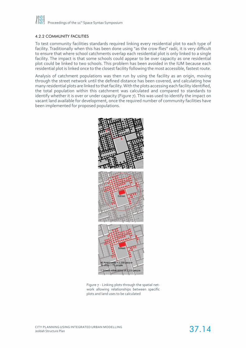
4.2.2 COMMUNITY FACILITIES
To test community facilities standards required linking every residential plot to each type of facility. Traditionally when this has been done using “as the crow flies” radii, it is very difficult to ensure that where school catchments overlap each residential plot is only linked to a single facility. The impact is that some schools could appear to be over capacity as one residential plot could be linked to two schools. This problem has been avoided in the IUM because each residential plot is linked once to the closest facility following the most accessible, fastest route.
Analysis of catchment populations was then run by using the facility as an origin, moving through the street network until the defined distance has been covered, and calculating how many residential plots are linked to that facility. With the plots accessing each facility identified, the total population within this catchment was calculated and compared to standards to identify whether it is over or under capacity (Figure 7). This was used to identify the impact on vacant land available for development, once the required number of community facilities have been implemented for proposed populations.
Figure 7 - Linking plots through the spatial net-work allowing relationships between specific plots and land uses to be calculated
Proceedings of the 11th Space Syntax Symposium
CITY PLANNING USING INTEGRATED URBAN MODELLINGJeddah Structure Plan 37.15
4.2.3 ACCESS TO PUBLIC TRANSPORT
Analysis of the coverage of public transport options was carried out using catchment analysis. 15-minute catchments (by any mode of transport) were defined from proposed public transport stations and interchanges. The plots falling within these catchments were identified and translated into a proportion of residents within a 15-minute journey of public transport.
4.2.4 ACCESS TO PROPOSED TOWN, MULTI-DISTRICT AND DISTRICT CENTRES
Catchment populations were calculated from proposed centres that provide employment (town and multi-district centres). 30 and 15-minute travel times (using any mode) were used to define these catchments. Residential plots falling within these catchments were analysed to measure how many centres, and therefore opportunities for employment each plot has access to and what proportion of the population this equates to.
5. DISCUSSION
5.1 NEED FOR A WEIGHTED SPATIAL MODEL
Jeddah offered some unique spatial challenges for space syntax analysis to address. Many parts of the city had been subdivided by a street grid but were uninhabited. Unweighted space syntax models can be used to analyse the structure of the city based on its spatial configuration. This process overestimates the movement potential of the uninhabited grids. In reality, these grids would not generate any movement. The unweighted model would struggle to highlight these nuances of the existing cities structure.
The project required Space Syntax Limited to test the impact of changes to population and employment densities, proposed developments which lack spatial data. Since the unweighted model struggles to test the impact of proposed changes which do not change the street structure, the weighted space syntax model was developed. The effect of weighting in the context of the existing city was that street segments in an uninhabited sub-division (of which there are many) would not generate or receive any trips, however, they still allow movement through them if they form part of a wider journey. The weighted model also helped test the impact of different distributions of densities and developments by weighting the respective segments with origins and destinations.
While calculating the weightings, no specific time scenario (morning or evening) was modelled. The aim was to understand the potential urban activity caused by the spatial changes rather than the amount of movement generated at specific time periods. Hence the model was weighted as if all the population and jobs were impacting the model at the same time.
5.2 HOW IUM HELPED IN THE PLANNING PROCESS?
5.2.1 IDENTIFYING THE OPPORTUNITIES AND CONSTRAINTS OF THE EXISTING CITY
The analysis of existing centres and community facilities determined that it would be very difficult to deliver the current municipality guidelines for community facility standards in the existing urban context. This was due to the large number and size of facilities required, limited amount of suitable vacant land parcels in required proximity, and the existing street network and block structure that was not conducive to developing centres. The number and various types of facilities required may also be unsuitable for some parts of the city. Accordingly, it was necessary to revise the community facility standards to the context of the city.
The catchment analysis helped identify gaps in the existing distribution of social infrastructure. By connecting schools, hospitals etc. to their respective residential catchments, parts of the city with no coverage were identified. This helped locate the parts of the city which required immediate focus and helped develop a phasing strategy.
Proceedings of the 11th Space Syntax Symposium
CITY PLANNING USING INTEGRATED URBAN MODELLINGJeddah Structure Plan 37.16
The catchment analysis also helped develop a phasing strategy for the development of the public transport system. The results of the analysis of mapping the existing and proposed population and employment catchments from the proposed public transport lines, allowed the planners convince the client to choose the line which would benefit parts of the existing city the most, rather than the line which was going to connect the proposed mega projects.
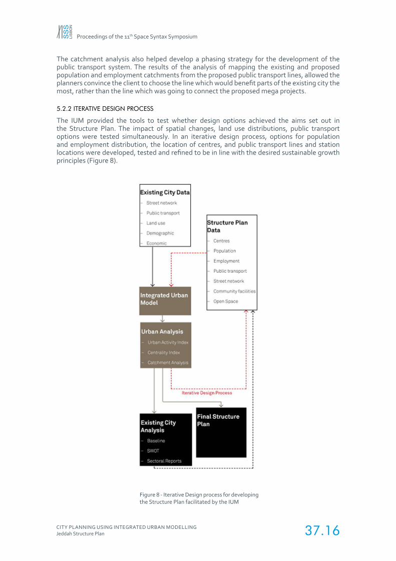
5.2.2 ITERATIVE DESIGN PROCESS
The IUM provided the tools to test whether design options achieved the aims set out in the Structure Plan. The impact of spatial changes, land use distributions, public transport options were tested simultaneously. In an iterative design process, options for population and employment distribution, the location of centres, and public transport lines and station locations were developed, tested and refined to be in line with the desired sustainable growth principles (Figure 8).
Figure 8 - Iterative Design process for developing the Structure Plan facilitated by the IUM
Proceedings of the 11th Space Syntax Symposium
CITY PLANNING USING INTEGRATED URBAN MODELLINGJeddah Structure Plan 37.17
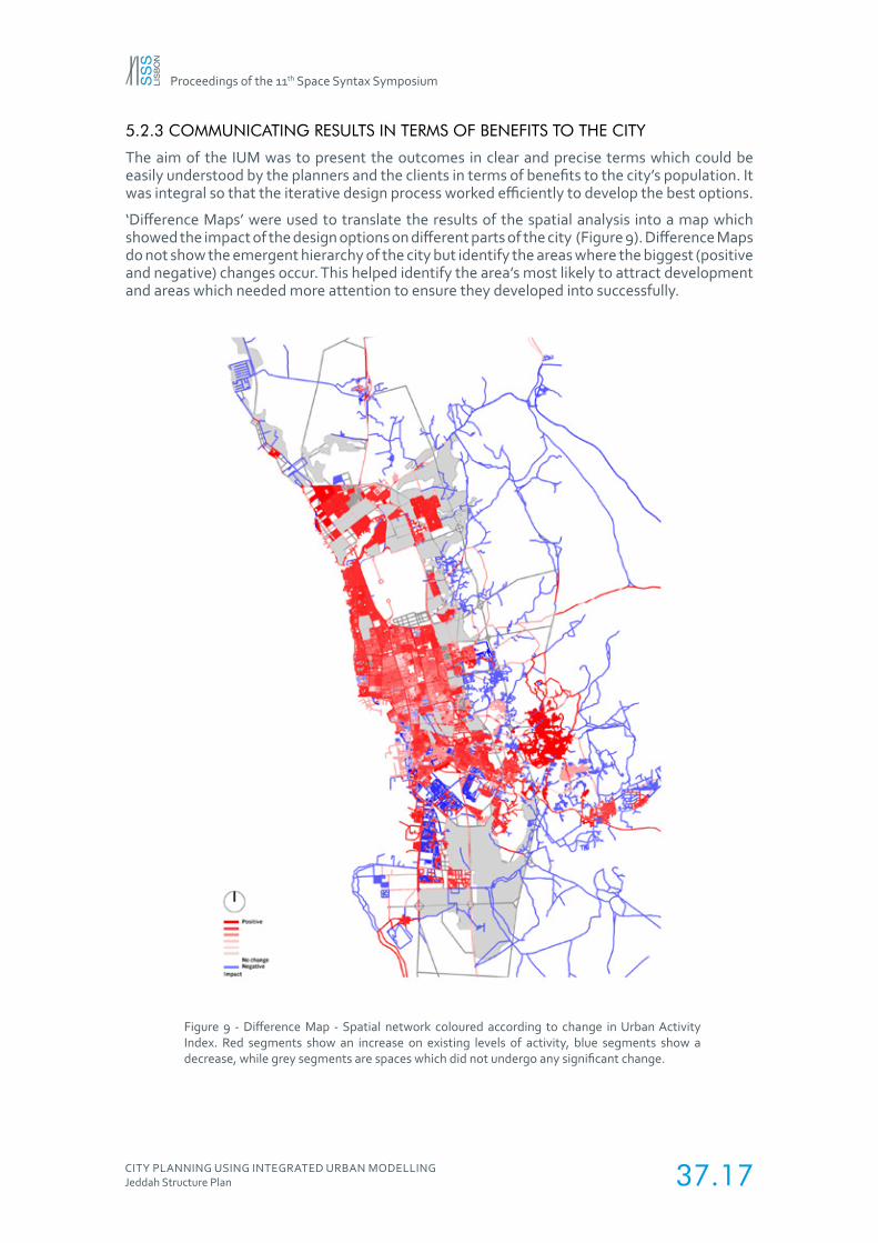
5.2.3 COMMUNICATING RESULTS IN TERMS OF BENEFITS TO THE CITY
The aim of the IUM was to present the outcomes in clear and precise terms which could be easily understood by the planners and the clients in terms of benefits to the city’s population. It was integral so that the iterative design process worked efficiently to develop the best options.
‘Difference Maps’ were used to translate the results of the spatial analysis into a map which showed the impact of the design options on different parts of the city (Figure 9). Difference Maps do not show the emergent hierarchy of the city but identify the areas where the biggest (positive and negative) changes occur. This helped identify the area’s most likely to attract development and areas which needed more attention to ensure they developed into successfully.
Figure 9 - Difference Map - Spatial network coloured according to change in Urban Activity Index. Red segments show an increase on existing levels of activity, blue segments show a decrease, while grey segments are spaces which did not undergo any significant change.
Proceedings of the 11th Space Syntax Symposium
CITY PLANNING USING INTEGRATED URBAN MODELLINGJeddah Structure Plan 37.18
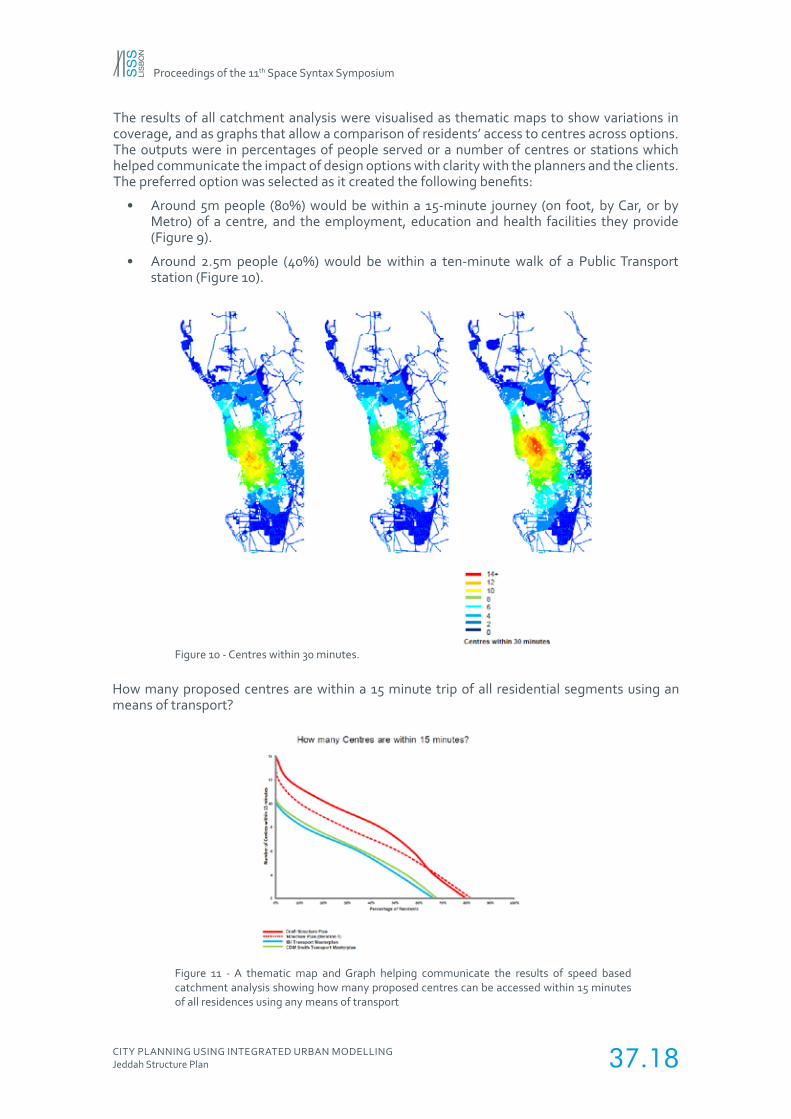
The results of all catchment analysis were visualised as thematic maps to show variations in coverage, and as graphs that allow a comparison of residents’ access to centres across options. The outputs were in percentages of people served or a number of centres or stations which helped communicate the impact of design options with clarity with the planners and the clients. The preferred option was selected as it created the following benefits:
• Around 5m people (80%) would be within a 15-minute journey (on foot, by Car, or by Metro) of a centre, and the employment, education and health facilities they provide (Figure 9).
• Around 2.5m people (40%) would be within a ten-minute walk of a Public Transport station (Figure 10).
How many proposed centres are within a 15 minute trip of all residential segments using an means of transport?
Figure 11 - A thematic map and Graph helping communicate the results of speed based catchment analysis showing how many proposed centres can be accessed within 15 minutes of all residences using any means of transport
Figure 10 - Centres within 30 minutes.
Proceedings of the 11th Space Syntax Symposium
CITY PLANNING USING INTEGRATED URBAN MODELLINGJeddah Structure Plan 37.19
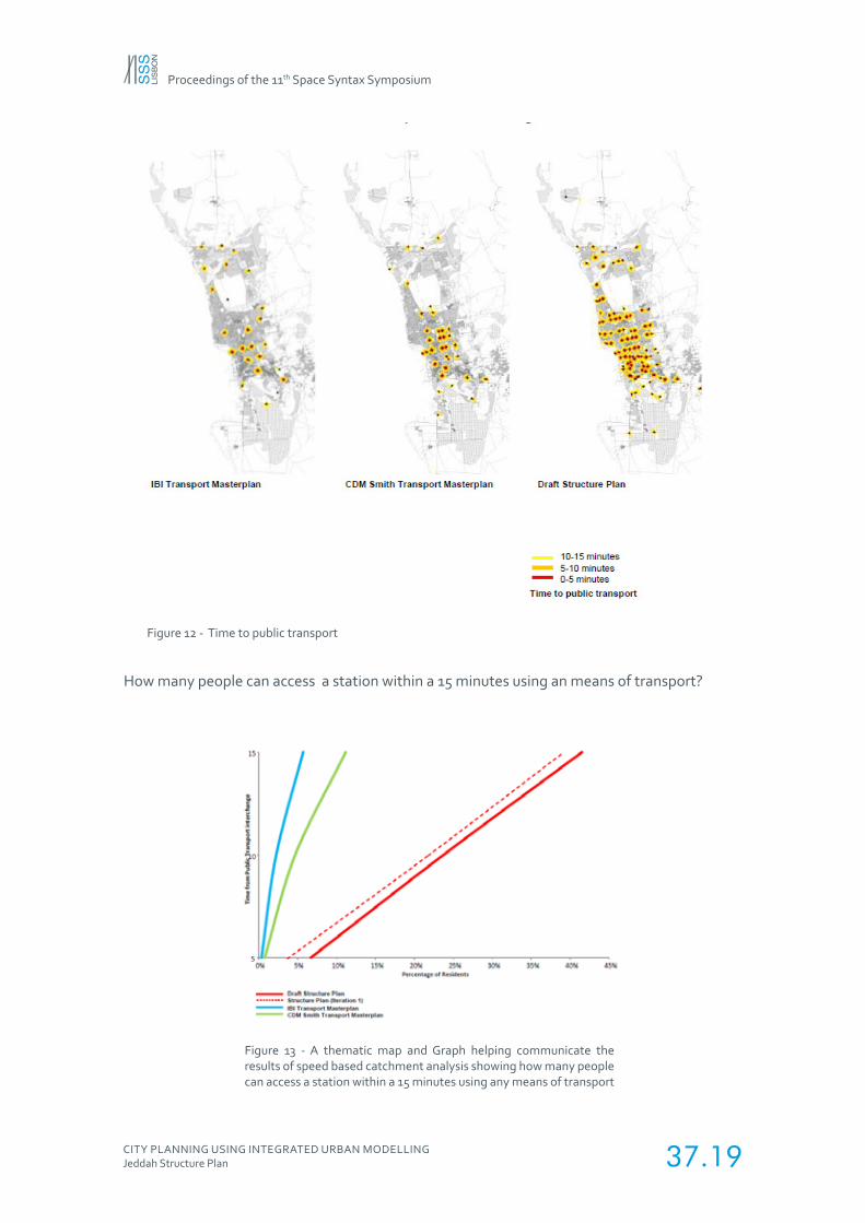
How many people can access a station within a 15 minutes using an means of transport?
Figure 13 - A thematic map and Graph helping communicate the results of speed based catchment analysis showing how many people can access a station within a 15 minutes using any means of transport
Figure 12 - Time to public transport
Proceedings of the 11th Space Syntax Symposium
CITY PLANNING USING INTEGRATED URBAN MODELLINGJeddah Structure Plan 37.20
6. ACADEMIC CONTEXT VERSUS PRACTICE / PROJECT DECISIONS
The methodologies and measures developed to test the growth scenarios were designed to aid the planners to make the best decisions to achieve the aims of the Structure plan. The methodologies may not be academically robust but tried to provide the most accurate results in light of the data available. For example, while distributing weightings to segments the data was aggregated up to the superblock level from the plots and then distribute to the segments as a proposition of their segment length. This was done as the superblocks were a useful output area for the planners to work with as they responded not only to the spatial conditions of the city but also administrative boundaries and proposed projects. This helped the planners make decisions which would be in line with the city’s municipal structure and not drastically against the proposed developments which were already approved for development. Aggregating the land use data to superblocks was also an effective way to distribute population and jobs as there was no data available regarding the entrances of the buildings.
Another example was identifying potential locations for Town, Multi-District and District centres. The hierarchy of centres and their initial locations were developed to try and respond the existing issues of the cities and the framework developed by AECOM in the Strategic, Sub-regional and Structure plans for the city. The measure and scales used were also selected to best answer the questions posed by the planners. Since there was no actual movement data available it was not possible to compare the measures with actual movement to see if they had a statistically relevant correlation.
7. CONCLUSIONS
The IUM was a key design tool in refining the plan and optimising the relationships between population, employment and public transport. Linking the spatial model to land use and public transport allowed queries of multiple conditions to be carried out simultaneously – e.g. where in the city is a potential centre location which is accessible both globally and locally has vacant land and has a specific existing population density. The IUM thus allows planners to work across departmental silos and test the impact of different urban components simultaneously.
The IUM was used to provide a benchmarking methodology to compare options in terms that a non-expert could easily interpret. For example, what is the number of jobs within 30 minutes of all residential land uses rather than accessibility values of segments. This allows the planners quickly assess the options in regards to the aims of the plan and also help communicate with clarity with the clients with clarity why an option was chosen.
Subsequently, the IUM was also used for the Jeddah Metro project where Space Syntax Limited worked with an internationally renowned architectural firm to profile the metro routes, categorise stations, and test station locations etc. Since the proposed plan for the Metro system was based on the Structure Plan the IUM helped link the outputs of the Structure plan and the detailed design of the Metro system to ensure a sustainable design of the public transport system.
Proceedings of the 11th Space Syntax Symposium
CITY PLANNING USING INTEGRATED URBAN MODELLINGJeddah Structure Plan 37.21
REFERENCES
AECOM. (2013). Jeddah Strategic Plan Revision. Jeddah, Saudi Arabia: Municipality of Jeddah.
AECOM. (2014). Jeddah Sub-Regional Plan, Sectoral reports. Jeddah, Saudi Arabia: Municipality of Jeddah.
AECOM. (2015). Jeddah Structure Plan. Jeddah, Saudi Arabia: Municipality of Jeddah.
Bahaydar, M. H. (2013). Urban Sprawl and Its Negative Effects on Jeddah. Daghistani, A.-M. (1993, November). A case study in planning implementation, Jeddah, Saudi Arabia, Newcastle.
Dhanani, A., Vaughan, L., Ellul, C., & Griffiths, S. (2012). From the axial line to the walked line: evaluating the utility of commercial and user-generated street network datasets in space syntax analysis. In Eighth International Space Syntax Symposium. Santiago, Chile.
El-Shafie, M. (2010). Human-Environment Interactions: Phenomenal Relationships. International Journal of Civil & Environmental Engineering, 10(04), 21–29.
Griffiths, S., Vaughan, L., Haklay, M. (Muki), & Emma Jones, C. (2008). The Sustainable Suburban High Street: A Review of Themes and Approaches. Geography Compass, 2(4), 1155–1188. doi:10.1111/j.1749- 8198.2008.00117.x
Hillier, B. (1996). Space is the Machine: A Configurational Theory of Architecture. Cambridge University Press.
Hillier, B. (2001). Centrality as a process: accounting for attraction inequalities in deformed grids. Urban Design International, 4(3), 107–127.
Hillier, B. (2002). A Theory of the City as Object: or, how spatial laws mediate the social construction of urban space. Urban Design International, 3-4(127), 153–179.
Hillier, B. (2009). Spatial sustainability in cities: organic patterns and sustainable forms. In Proceedings of the 7th International Space Syntax Symposium. Stockholm, Sweden.
Hillier, B., & Iida, S. (2005). Network and Psychological Effects in Urban Movement. In A. Cohn & D. Mark (Eds.), Spatial Information Theory (Vol. 3693, pp. 475–490). Springer Berlin / Heidelberg. Retrieved from http://www.springerlink.com/content/10853tquj1mpf95j/abstract/
Hillier, B., & Penn, A. (1996). Cities as Movement Economies. Urban Design International, 1(1), 49–60.
Hillier, B., Penn, A., Hanson, J., Grajewski, T., & Xu, J. (1993). Natural Movement: or configuration and attraction in urban pedestrian movement. Environment and Planning B: Planning and Design, 20, 29–66.
Hillier, B., & Stonor, T. (2010). Space Syntax - Strategic Urban Design. City Planning Review, The City Planning Institute of Japan, 59/no.3(285), 7–11.
Hillier, B., Yang, T., & Turner, A. (2012, January). Advancing Depthmap to advance our understanding of cities: comparing streets and cities and streets with cities [Proceedings paper]. Retrieved February 9, 2015, from http://www.sss8.cl/proceedings/
Karimi, K, Parham, E. Acharya, A. (2015). Integrated sub-regional planning informed by weighted spatial network models: The case of Jeddah sub-regional system. In the Tenth International Space Syntax Symposium. London, England
Karimi, K. (2009). New Towns of England in Transition: reshaping through understanding the reasons for failure. In Model Town: Using Urban Simulation in New Town Planning. Almere, Netherlands: International New Towns Institute. Karimi, K. (2012). Evidence-informed and analytical methods in urban design. Urban Design International, 17(4), 253–256. doi:10.1057/udi.2012.24
Karimi, K., & Parham, E. (2012). An evidence-informed approach to developing an adaptable regeneration programme for declining informal settlements. In Eighth International Space Syntax Symposium. Santiago, Chile.
Karimi, K., Parham, E., Fridrisch, E., & Ferguson, P. (2013). Origin-destination weighted choice model as a new tool for assessing the impact of new urban developments’. In Proceedings of the Ninth International Space Syntax Symposium.
Penn, A. (2008). Architectural Research. In A. Knight & L. Ruddock (Eds.), Advanced Research Methods in the Built Environment (pp. 14–27). Wiley-Blackwell.
Penn, A., Hillier, B., Banister, D., & Xu, J. (1998). Configurational modelling of urban movement networks. Environment and Planning B: Planning and Design, 25(1), 59–84. Space Syntax Limited. (2006). Jeddah Strategic Planning Framework.