city zoning ordinance 11-9-2010 - cmcrpc.com city zoning ordinance 11-9-2010.pdf · zoning...
TRANSCRIPT
1
ZONING ORDINANCE
OF THE CITY OF
CLARKSVILLE, TENNESSEE
PREPARED BY:
CLARKSVILLE-MONTGOMERY COUNTY REGIONAL PLANNING COMMISSION
NOVEMBER, 1974
REPRINTED: NOVEMBER 9, 2010
(Includes Amendments 1-119)

2
3
TABLE OF CONTENTS CHAPTER 1 REGIONAL PLANNING COMMISSION ................................................................1
SECTION 11-101 ............ REGIONAL COMMISSION DESIGNATED AS ......................................... CITY'S COMMISSION ......................................................................1
CHAPTER 2 GENERAL PROVISIONS RELATING TO ZONING ............................................2 SECTION 11-201 ............ TITLE (Ordinance No. 7-1974-75) .....................................................2 SECTION 11-202 ............ GENERAL REQUIREMENTS ..........................................................2 SECTION 11-203 ............ DEFINITIONS ....................................................................................2 SECTION 11-204 ............ ESTABLISHMENT OF ZONING DISTRICTS ................................13 SECTION 11-205 ............ ZONING DISTRICT MAP AND AIRPORT DISTRICT MAP .........14 SECTION 11-206 ............ BOUNDARIES OF ZONE DISTRICTS ............................................14 SECTION 11-207 ............ BOUNDARIES OF ZONE DISTRICTS AFTER VACATION .........14 SECTION 11-208 ............ ZONING FOR NEWLY INCORPORATED AREAS ........................15 SECTION 11-209 ............ SUBDIVISION PLAT APPROVAL ..................................................15
CHAPTER 3 DISTRICT REGULATIONS ......................................................................................16 SECTION 11-301 ............ E-1 SINGLE FAMILY ESTATE DISTRICT .....................................16 SECTION 11-301.1 ......... AG AGRICULTURAL DISTRICT ....................................................17 SECTION 11-302 ............ R-1 SINGLE FAMILY RESIDENTIAL DISTRICT ..........................18 SECTION 11-321 ............ R-1A SINGLE FAMILY RESIDENTIAL DISTRICT .......................85 SECTION 11-303 ............ RM-1 SINGLE FAMILY MOBILE HOME RESIDENTIAL ......................................... DISTRICT ...........................................................................................20 SECTION 11-304 ............ R-2 SINGLE FAMILY RESIDENTIAL DISTRICT ..........................22 SECTION 11-322 ............ R-2D ONE AND TWO FAMILY RESIDENTIAL DISTRICT .........86 SECTION 11-305 ............ R-3 TWO AND THREE FAMILY RESIDENTIAL DISTRICT .......23 SECTION 11-306 ............ R-4 MULTIPLE FAMILY RESIDENTIAL DISTRICT ....................25 SECTION 11-323 ............ MIXED LAND USE DISTRICT ........................................................87 SECTION 11-307 ............ PUD PLANNED UNIT DEVELOPMENT RESIDENTIAL ......................................... DISTRICT ...........................................................................................27 SECTION 11-307.1 ......... OP OFFICE, PROFESSIONAL DISTRICT .......................................40 SECTION 11-308 ............ O-1 OFFICE, MEDICAL, INSTITUTIONAL AND CIVIC ......................................... DISTRICT ...........................................................................................41 SECTION 11-309 ............ C-1 NEIGHBORHOOD COMMERCIAL DISTRICT .......................42 SECTION 11-310 ............ C-2 GENERAL COMMERCIAL DISTRICT ....................................44 SECTION 11-311 ............ C-3 SHOPPING CENTER DISTRICT ...............................................46 SECTION 11-312 ............ CBD CENTRAL BUSINESS DISTRICT ..........................................48 SECTION 11-313 ............ C-4 HIGHWAY INTERCHANGE DISTRICT ..................................49 SECTION 11-314 ............ C-5 HIGHWAY AND ARTERIAL COMMERCIAL DISTRICT .....51 SECTION 11-315 ............ H-1 HISTORICAL DISTRICT ...........................................................53 SECTION 11-316 ............ M-1 LIGHT INDUSTRIAL DISTRICT .............................................57 SECTION 11-317 ............ M-2 GENERAL INDUSTRIAL DISTRICT ......................................59 SECTION 11-318 ............ M-3 PLANNED INDUSTRIAL DISTRICT ......................................61 SECTION 11-319 ............ FW FLOODWAY DISTRICT ............................................................64 SECTION 11-320 ............ AP AIRPORT OVERLAY DISTRICT ...............................................81
CHAPTER 4 OFF-STREET PARKING, STORAGE, AND LOADING REQUIREMENTS .....95 SECTION 11-401 ............ OFF-STREET PARKING REQUIREMENTS ...................................95 SECTION 11-402 ............ STORAGE AND PARKING OF TRAILERS AND ......................................... COMMERCIAL VEHICLES .............................................................97 SECTION 11-403 ............ OFF-STREET LOADING AND UNLOADING ......................................... REQUIREMENTS ..............................................................................98
CHAPTER 5 SIGNS, BILLBOARDS, AND OTHER ADVERTISING STRUCTURES .............99 SECTION 11-501 ............ GENERAL PURPOSE........................................................................99 SECTION 11-502 ............ REGULATIONS APPLYING TO ALL DISTRICTS ........................99 SECTION 11-503 ............ RESIDENTIAL DISTRICTS ..............................................................103 SECTION 11-504 ............ OP AND O1 DISTRICTS ...................................................................103 SECTION 11-505 ............ COMMERCIAL AND SHOPPING CENTER DISTRICTS ..............104
4
SECTION 11-506 ............ H-1 DISTRICT ...................................................................................104 SECTION 11-507 ............ INDUSTRIAL AND MANUFACTURING DISTRICTS ..................105 SECTION 11-508 ............ RESERVED ........................................................................................105 SECTION 11-509 ............ CBD CENTRAL BUSINESS DISTRICT ..........................................105 SECTION 11-510 ............ DOWNTOWN SIDEWALK SIGNS ..................................................106
CHAPTER 6 SUPPLEMENTARY REGULATIONS AND MODIFICATIONS .........................108 SECTION 11-601 ............ CEMETERY .......................................................................................108 SECTION 11-602 ............ DRIVE-IN THEATER ........................................................................108 SECTION 11-603 ............ DAY CARE FACILITIES ..................................................................109 SECTION 11-604 ............ MOBILE HOME PARKS ...................................................................110 SECTION 11-605 ............ CBD – CENTRAL BUSINESS DISTRICT ......................................... RESIDENTIAL USE ..........................................................................113 SECTION 11-606 ............ AUTOMOBILE WRECKING AND JUNK YARDS .........................114 SECTION 11-607 ............ CUSTOMARY HOME OCCUPATION ............................................115 SECTION 11-608 ............ TEMPORARY USES .........................................................................115 SECTION 11-609 ............ TENTS ................................................................................................116 SECTION 11-610 ............ FALL-OUT SHELTERS ....................................................................116 SECTION 11-611 ............ HEIGHT ..............................................................................................116 SECTION 11-612 ............ YARDS, BUILDING SETBACK AND OPEN SPACE ......................................... EXCEPTIONS ....................................................................................117 SECTION 11-613 ............ SPECIAL AREA REQUIREMENTS FOR ANY LOT ......................................... WITHOUT SANITARY SEWER ......................................................125 SECTION 11-613.1 ......... SITE PLAN REQUIREMENTS .........................................................125 SECTION 11-614 ............ TOW-IN LOTS ...................................................................................130 SECTION 11-615 ............ RECYCLING COLLECTION FACILITIES ......................................130 SECTION 11-616 ............ ADULT-ORIENTED ESTABLISHMENTS ......................................132 SECTION 11-617 ............ COMMUNICATION STATIONS AND TOWERS ...........................132 SECTION 11-618 ............ OPEN-AIR MARKETS ......................................................................133 SECTION 11-619 ............ BED AND BREAKFAST ESTABLISHMENTS ...............................134 SECTION 11-620 ............ LANDSCAPE, BUFFERING AND SCREENING ......................................... REQUIREMENTS ..............................................................................135
CHAPTER 7 NON-CONFORMING BUILDINGS, STRUCTURES, AND USES OF LAND ....164 SECTION 11-701 ............ EXISTING NONCONFORMING USES, ETC. .................................164 SECTION 11-702 ............ ALTERATION OR ENLARGEMENT OF BUILDINGS AND ......................................... STRUCTURES ...................................................................................164 SECTION 11-703 ............ OUTDOOR ADVERTISING SIGNS AND STRUCTURES .............164 SECTION 11-704 ............ BUILDING VACANCY .....................................................................164 SECTION 11-705 ............ CHANGE IN USE ..............................................................................165 SECTION 11-706 ............ NONCONFORMING USES OF LAND ............................................165 SECTION 11-707 ............ DAMAGE ...........................................................................................165 SECTION 11-708 ............ MOBILE HOMES ..............................................................................166
CHAPTER 8 ADMINISTRATION AND ENFORCEMENT .........................................................167 SECTION 11-801 ............ ORGANIZATION ..............................................................................167 SECTION 11-802 ............ VARIANCES ......................................................................................169 SECTION 11-803 ............ PROCEDURE FOR USES PERMITTED ON REVIEW ...................170 SECTION 11-804 ............ AMENDMENTS ................................................................................171 SECTION 11-805 ............ FEES ...................................................................................................172 SECTION 11-806 ............ ENFORCEMENT ...............................................................................172 SECTION 11-807 ............ BUILDING PERMIT ..........................................................................172 SECTION 11-808 ............ CERTIFICATE OF OCCUPANCY ....................................................173 SECTION 11-809 ............ VIOLATIONS ....................................................................................173 SECTION 11-810 ............ INTERPRETATION ...........................................................................173 SECTION 11-811 ............ AMENDMENTS AFFECTING SAME PARCEL OF LAND ...........173
CHAPTER 9 MADISON STREET CORRIDOR DESIGN REVIEW BOARD ...........................174 SECTION 11-901 ........... CREATION AND ADOPTION OF MADISON STREET

5
CORRIDOR URBAN DESIGN OVERLAY AND DESIGN STANDARDS AND GUIDELINES ...................................................174 SECTION 11-902 ............ MADISON STREET CORRIDOR DESIGN REVIEW BOARD ......174 SECTION 11-903 ............ AUTHORIZATION TO CHARGE FEES ..........................................174

6
7
Chapter 1
REGIONAL PLANNING COMMISSION
Sec. 11-101. Regional commission designated as city's commission. Pursuant to section 13-3-301, Tennessee Code Annotated, the Clarksville-Montgomery County Regional Planning Commission created pursuant to section 13-3-101, Tennessee Code Annotated, is hereby designated as the city's planning commission.
8
Chapter 2
GENERAL PROVISIONS RELATING TO ZONING Sec. 11-201. Title. Chapters 2 through 8 of this title shall be known and may be cited as "The Zoning Ordinance of the City of Clarksville, Tennessee." They may also be known as the "Clarksville Zoning Ordinance." Sec. 11-202. General requirements. Except as hereinafter provided, no building shall be erected or structurally altered, nor shall any building or premises be used for any purpose other than permitted in the zoning district in which the building or premises is located. No land or lot area shall be so reduced or diminished that the yards or open spaces are less than prescribed herein, nor shall the lot area per family be reduced in any manner except in conformity with the area regulations hereby established for the district in which such building is located. No yard or other open space provided about any building for the purpose of complying with these regulations shall be considered as providing a yard or other open space for any other building. (Ord. No. 7-1974-75, § 30-4) Sec. 11-203. Definitions. For the purpose of chapters 2 through 8 of this title, certain terms used herein are herewith defined. When not inconsistent with the context, words used in the present tense include the future; words used in the singular include the plural; the word "person" includes a firm, partnership, or corporation as well as an individual; the word "lot" includes the word "plot," "parcel," or "site"; the word "building" includes the word "structure"; and the term "shall" is always mandatory and not directory; and the word "may" is permissive. The word "used" or "occupied" as applied to any land or building shall be construed to include the words "intended, arranged, or designed to be used or occupied." (1) Accessory building or structure: A building or structure the use of which is subordinate or incidental to that of the main building, structure, or use. Where an accessory building is an integral part of, or is joined to the main building, such accessory building shall be considered to be part of the main building. (2) Accessory use: A use customarily incidental, appropriate, and subordinate to the principal use of land or building and devoted exclusively to the main use of the premises. (2.1) Adult-oriented business establishment: An establishment defined in section 5-1200 of this Code and the provisions of section 5-1200, as adopted on September 7, 2000, and as may be amended from time to time thereafter, are adopted and incorporated by reference herein. (3) Agricultural uses: This includes the growing of crops in the open, dairying, grazing, the raising and maintenance of poultry and other livestock, horticulture, viticulture, floriculture,
9
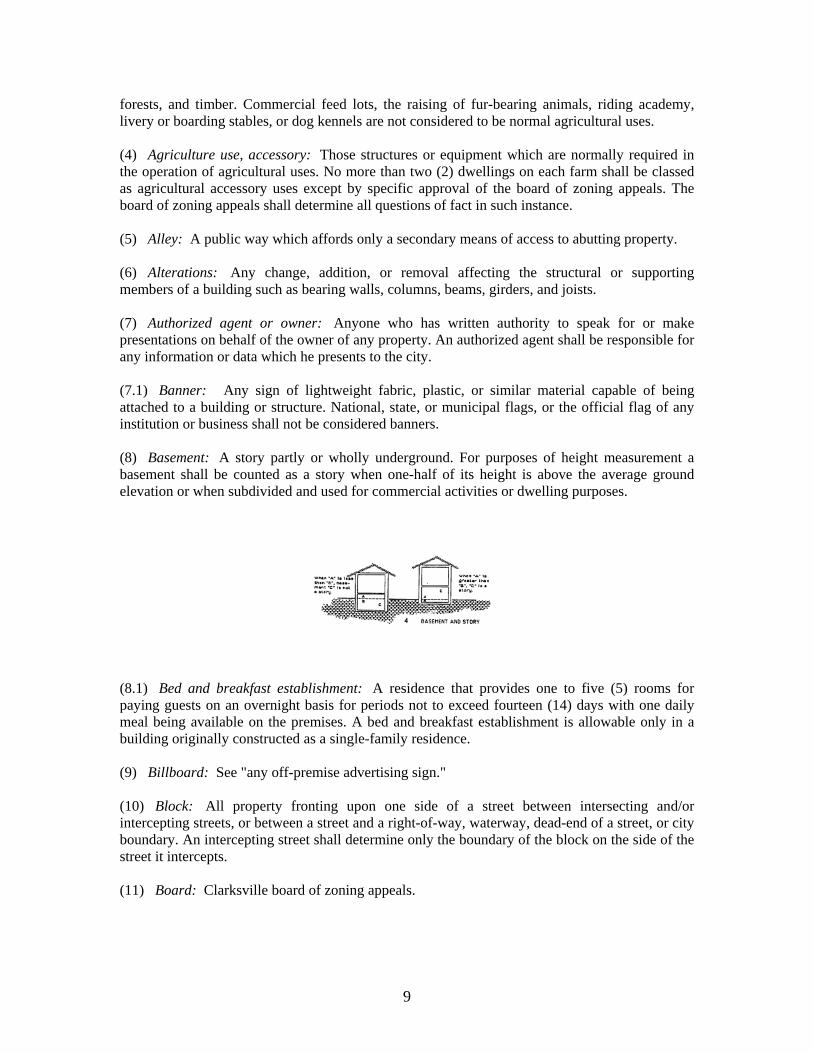
forests, and timber. Commercial feed lots, the raising of fur-bearing animals, riding academy, livery or boarding stables, or dog kennels are not considered to be normal agricultural uses. (4) Agriculture use, accessory: Those structures or equipment which are normally required in the operation of agricultural uses. No more than two (2) dwellings on each farm shall be classed as agricultural accessory uses except by specific approval of the board of zoning appeals. The board of zoning appeals shall determine all questions of fact in such instance. (5) Alley: A public way which affords only a secondary means of access to abutting property. (6) Alterations: Any change, addition, or removal affecting the structural or supporting members of a building such as bearing walls, columns, beams, girders, and joists. (7) Authorized agent or owner: Anyone who has written authority to speak for or make presentations on behalf of the owner of any property. An authorized agent shall be responsible for any information or data which he presents to the city. (7.1) Banner: Any sign of lightweight fabric, plastic, or similar material capable of being attached to a building or structure. National, state, or municipal flags, or the official flag of any institution or business shall not be considered banners. (8) Basement: A story partly or wholly underground. For purposes of height measurement a basement shall be counted as a story when one-half of its height is above the average ground elevation or when subdivided and used for commercial activities or dwelling purposes.
(8.1) Bed and breakfast establishment: A residence that provides one to five (5) rooms for paying guests on an overnight basis for periods not to exceed fourteen (14) days with one daily meal being available on the premises. A bed and breakfast establishment is allowable only in a building originally constructed as a single-family residence. (9) Billboard: See "any off-premise advertising sign." (10) Block: All property fronting upon one side of a street between intersecting and/or intercepting streets, or between a street and a right-of-way, waterway, dead-end of a street, or city boundary. An intercepting street shall determine only the boundary of the block on the side of the street it intercepts. (11) Board: Clarksville board of zoning appeals.
10
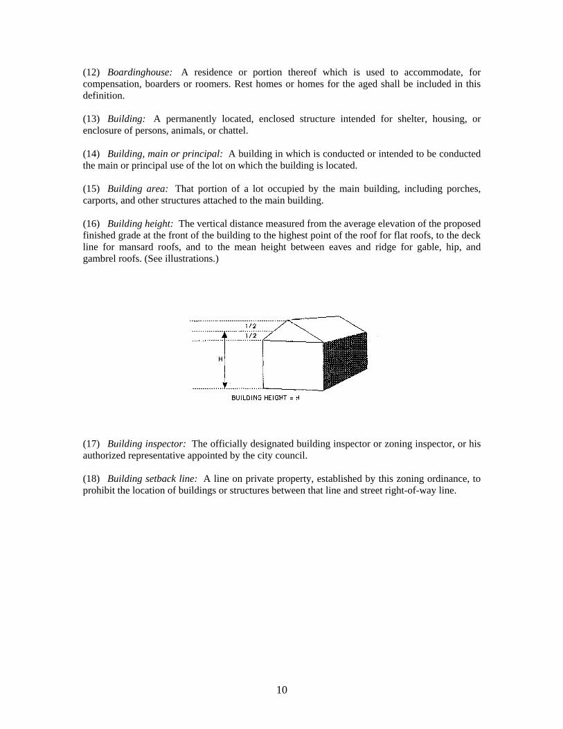
(12) Boardinghouse: A residence or portion thereof which is used to accommodate, for compensation, boarders or roomers. Rest homes or homes for the aged shall be included in this definition. (13) Building: A permanently located, enclosed structure intended for shelter, housing, or enclosure of persons, animals, or chattel. (14) Building, main or principal: A building in which is conducted or intended to be conducted the main or principal use of the lot on which the building is located. (15) Building area: That portion of a lot occupied by the main building, including porches, carports, and other structures attached to the main building. (16) Building height: The vertical distance measured from the average elevation of the proposed finished grade at the front of the building to the highest point of the roof for flat roofs, to the deck line for mansard roofs, and to the mean height between eaves and ridge for gable, hip, and gambrel roofs. (See illustrations.)
(17) Building inspector: The officially designated building inspector or zoning inspector, or his authorized representative appointed by the city council. (18) Building setback line: A line on private property, established by this zoning ordinance, to prohibit the location of buildings or structures between that line and street right-of-way line.
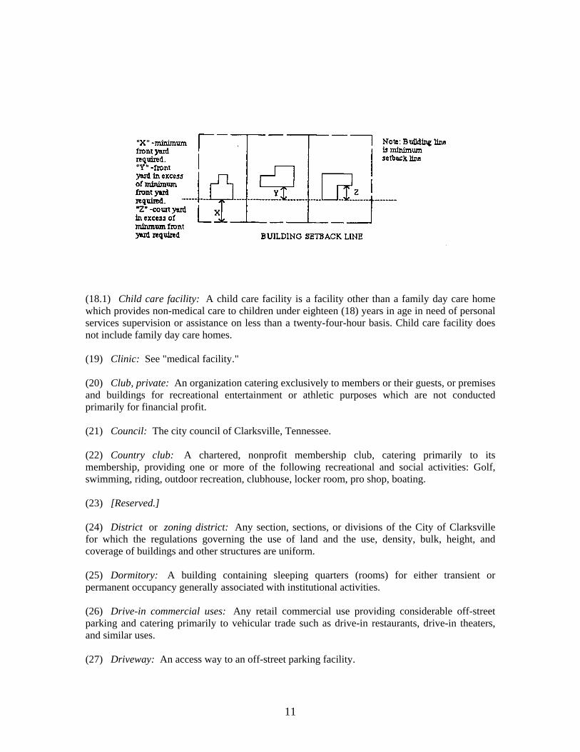
11
(18.1) Child care facility: A child care facility is a facility other than a family day care home which provides non-medical care to children under eighteen (18) years in age in need of personal services supervision or assistance on less than a twenty-four-hour basis. Child care facility does not include family day care homes. (19) Clinic: See "medical facility." (20) Club, private: An organization catering exclusively to members or their guests, or premises and buildings for recreational entertainment or athletic purposes which are not conducted primarily for financial profit. (21) Council: The city council of Clarksville, Tennessee. (22) Country club: A chartered, nonprofit membership club, catering primarily to its membership, providing one or more of the following recreational and social activities: Golf, swimming, riding, outdoor recreation, clubhouse, locker room, pro shop, boating. (23) [Reserved.] (24) District or zoning district: Any section, sections, or divisions of the City of Clarksville for which the regulations governing the use of land and the use, density, bulk, height, and coverage of buildings and other structures are uniform. (25) Dormitory: A building containing sleeping quarters (rooms) for either transient or permanent occupancy generally associated with institutional activities. (26) Drive-in commercial uses: Any retail commercial use providing considerable off-street parking and catering primarily to vehicular trade such as drive-in restaurants, drive-in theaters, and similar uses. (27) Driveway: An access way to an off-street parking facility.
12
(28) Dwelling: A building or portion thereof used for residential occupancy. (29) Dwelling, attached: A dwelling with two (2) or more party walls, or one party wall in the case of a dwelling at the end or a group of attached dwellings. (30) Dwelling, semidetached: Two (2) dwellings with a single party wall common to both. (31) Dwelling, single-family: A detached building so designed and arranged to provide sleeping, cooking, and kitchen accommodations and toilet facilities for occupancy by one family only, together with such domestic help as is necessary to service and maintain the premises and their occupants. (32) Dwelling, two-and three-family: A building so designed and arranged to provide sleeping, cooking, and kitchen accommodations and toilet facilities for occupancy of two (2) or three (3) families. (33) Dwelling unit: One or more rooms and a single kitchen designed as a unit for occupancy by one family only, for cooking, living, and sleeping purposes. (34) Family: One or more persons related by blood, marriage, or adoption, or a group of not more than five (5) persons unrelated by blood or marriage, occupying the premises and living as a single nonprofit housekeeping unit as distinguished from a group occupying a boarding or lodging house or similar dwelling for group use. A family shall be deemed to include domestic servants employed by the family. (34.1) Family day care home: A home which regularly provides care, protection, and supervision of twelve (12) or fewer children, in the providers' own home, for periods of less than twenty-four (24) hours a day, while the parents or guardians are away, and includes the following:
a. Large family day care home: A home which provides family day care to five (5) to twelve (12) children, inclusive, including children who reside at the home.
b. Small family day care home: A home which provides family day care to four (4) or fewer children, including children who reside at the home.
(35) Floor area: The sum of the gross floor area for each of the several stories under roof, measured from the interior limits of walls of a building or structure. (36) Fraternity or sorority house: A building housing the members of a fraternity or sorority group living together under a cooperative arrangement as distinguished from a boarding or lodging house. (36.1) Freestanding sign: Any sign supported by structures or supports that are placed on, or anchored in, the ground and that are independent from any building or other structure. (37) Frontage: All property on one side of a street between two (2) intersecting streets (crossing or terminating) measured along the line of the street, or if the street has a dead end, then all of the property abutting the dead end and/or turnaround of the street.
13
(38) Garage, private: An accessory building or part of a main building for which the principal use is storage of privately owned vehicles. (39) Garage, public or repair: A building in which the principal operation involves a garage used for the storage, repair, servicing, or equipping of vehicles for profit. (40) Gasoline or service station: Any building, structure, or land used primarily for the dispensing or sale of fuels, oils, accessories, or minor maintenance and repair services but not including painting, major repairs, or automatic washing facilities. (41) Grade, finished: The completed surfaces of lawns, walks, and roads brought to grades as shown on plans or designs relating thereto. (42) Guest house: See "tourist home." (43) Health department: The Clarksville-Montgomery County Health Department. (44) Health officer: The director of a city, county, or district health department having jurisdiction over the community in an area, or his duly authorized representative. (45) Historical monuments and/or structures: Any structure or building existing contemporaneously with and commonly associated with an outstanding event or period of history, and any structure or building in which the relics and/or mementoes of such event or period are housed and preserved. (46) Home occupation: See section 11-607. (46.1) Homeless shelter: A facility providing temporary housing to indigent, needy, homeless, or transient persons, and may also provide ancillary services such as counseling, religious instruction, vocational training, etc. (47) Hazardous or noxious uses: All uses which involve the storage, sale, manufacture, processing or handling of materials or activities which are highly flammable, explosive, noxious, toxic, or inherently dangerous to humans, animals, land, crops, or property. (48) Hospitals: See "medical facilities." (49) Hotel: A building or part thereof occupied as the more or less temporary abiding place of individuals, in which the rooms are usually occupied single for hire and in which rooms no provision for cooking is made, and in which building there is usually a kitchen and public dining room for the accommodation of the occupants and guests. (50) House trailer: See "mobile home." (51) House trailer park: See "mobile home park." (52) Institution: A building or activity operated by either a profit or nonprofit corporation or establishment for public use. (53) Junkyard or salvage yard: A lot, land, or structure, or part thereof, used primarily for the collecting storage, and sale of waste paper, rags, scrap metal, or discarded material; or for the
14
collecting, dismantling, storage, and salvaging of machinery or vehicles not in running condition, or for the sale of parts thereof. (54) Lot: A parcel of land occupied or intended to be occupied by a building and its accessory buildings or by a dwelling or group of dwellings and their accessory buildings, together with such open spaces as are required under the provisions of chapters 2 through 8 of this title. (55) Lot, corner: A lot abutting upon two (2) or more streets at their intersection. (56) Lot, double frontage, or through lot: A lot which is an interior lot extending from one street to another and abutting a street on two (2) ends. (57) Lot lines: The lines bounding a lot as defined herein. (58) Lot line, front: In the case of an interior lot, the line separating the lot from that street which is designated as the front street in the request for a building permit. (59) Lot line, rear: The lot boundary opposite and most distant from the front lot line. In the case of a pointed or irregular lot, it shall be an imaginary line parallel to and farthest from the front lot line, not less than ten (10) feet long and wholly within the lot. (60) Lot line, side: Any lot line other than a front or rear lot line as defined herein. (61) Lot width: The width of a lot measured at the building setback line. (61.1) Market promoter, operator or owner: All persons or other forms of business entities
operating, maintaining and promoting open-air markets.* (62) Medical facilities:
(a) Convalescent, rest or nursing home: A health facility where persons are housed and furnished with meals and continuing nursing care. (b) Dental clinic, medical clinic, or mental health clinic: A facility for examination and treatment of human out-patients where patients are not kept overnight except under emergency conditions. (c) Dental office or doctor's office: Same as "dental or medical clinic." (d) Hospital: A public or proprietary facility providing medical diagnosis, treatment, or other care of human ailments, and which, unless otherwise specified, shall be deemed to include institutions primarily for treatment of contagious diseases and the insane or feeble-minded, but not including clinics as herein defined. (e) Sanitarium or Sanatorium: An institution providing health facilities for inpatient medical treatment and recuperation;
(62.1) Mini-warehouse: A building consisting of individual, self-contained units that are leased or owned for the storage of business and household goods or contractors supplies. (63) Mobile home: A mobile home is a single-family dwelling, other than a modular home, designed for transportation on its own chassis, and arriving at the site where it is to be occupied as a dwelling unit complete and ready for occupancy, except for minor and incidental unpacking and assembly operations, located on wheels or jacks or permanent foundation and connected to utilities and the like. A mobile home is considered to be dependent on public utilities the same as conventional dwellings. All mobile homes placed in the City of Clarksville from the date of
15
passage of the provisions of chapters 2 through 8 of this title shall meet all requirements of the Standard Building Code and National Electric Code. (64) Mobile home park: Any area, tract, site, or plot of land under single ownership, whereupon mobile home spaces are located and maintained and shall include all accessory buildings used or intended to be used in connection with the operation of a mobile home park. (65) Mobile home space: A plot of ground within a mobile home park or subdivision designed for the accommodation of one mobile home. (66) Mobile home subdivision: A mobile home subdivision is a subdivision intended for individual ownership of lots and designed for residential use of mobile homes exclusively. (67) Modular home or modular unit: A factory-fabricated building which can be transported to a site where it is to be placed on a permanent foundation, designed to be used primarily as a single-family dwelling or to be incorporated with similar units at a building site into a modular structure (but not including "mobile homes" or "house trailers"). The term is intended to apply to major assemblies and does not include prefabricated panels, trusses, plumbing trees, and other prefabricated subelements which are to be incorporated in a structure at the site. The structure must meet all construction standards necessary for approval by the Standard Building Code and National Electric Code. (68) Motel: A motel or motor court is a business comprised of a building or group of buildings so arranged as to furnish overnight accommodations for transient guests. (69) Nonconforming use: The use of any building, structure, or land which was lawful at the time of the passage of the provisions of chapters 2 through 8 of this title, or amendment thereto, but which does not now conform with the use regulations of the district in which it is situated. (69.1) Off-premise advertising sign: A sign that is used to advertise or inform by directing attention to a cause, event, campaign, business, profession, commodity, product, service, or entertainment which is conducted, sold, distributed, or offered elsewhere than upon the same premise as the off-premise sign, or which directs attention to any brand name or trade name product which may be incidentally available on the same premises as the off-premise sign. (69.2) Open-air market: An outdoor commercial activity, not including shopping centers, individual retail operations, yard sales or garage sales, that is open to the general public and composed of three (3) or more semi-enclosed or outdoor stalls, rooms, stands, booths, tables or spaces used for the purpose of display and sale, exchange, or barter of merchandise and is further defined as an occasional or periodic market held in an open area or structure where goods are offered for sale to the general public by individual sellers from open or semi-open facilities or temporary structures. This definition does not apply to sales associated with events or festivals as listed under chapter 5, section 5-1102 of this Code, or to events held on property owned by a governmental entity. (70) Parking lot: An off-street facility including parking spaces along with adequate provision for drives and aisles for maneuvering and providing access, and for entrance and exit, all laid out in a way to accommodate the parking of automobiles.
16
(71) Parking space: An off-street space available for the parking of one motor vehicle and having an area of not less than one hundred eighty (180) square feet, exclusive of passageways and driveways, and having direct access to a street or alley. (72) Planning commission: The Clarksville-Montgomery County Regional Planning Commission of Clarksville and Montgomery County. (72.1) Reserved. (73) Principal use: The specific primary purpose for which land or a building is used. (73.1) Public use: Any facility or use owned, operated, or maintained by a federal, state, or local governmental entity. (74) Public utility: Any person, firm, corporation, municipal department, or board duly authorized to furnish and furnishing, to the public, under regulations, electricity, gas, steam, telephone, telegraph, transportation, drainage, water, or sewer. (75) Road: That portion of a public thoroughfare or right-of-way intended for use by motor vehicles. (76) Road or street right-of-way line: That line surveyed or approved by the appropriate government authority as the outer boundary of a road or street. Such line is identical to or contiguous with any property line abutting a road or street and is often referred to as a road line or street line. (77) Roadside stand, agricultural: A farm structure used or intended to be used for the sale of only seasonal farm products. (78) Rooming houses: A dwelling other than a hotel, motel, or apartment house where lodging for three (3) or more persons not of the immediate family is provided for compensation and by prearrangement for definite time periods. (79) School, private: An institution of learning, including colleges and universities, that is not tax supported. (80) Shopping center: A group of commercial establishments, planned and developed with off-street parking provided on the property. (81) Sign: Any structure which displays or includes any letter, word, model, banner, flag, streamer/pennant, insignia, or representation used as, or which is in the nature of announcement, direction or advertisement. The word "sign" includes billboards or any other type of advertising device, but does not include the flag, pennant, or insignia of any nation, state, city, or other political unit, school, or religion. (81.1) Sign, Sidewalk: A sign with two faces that are adjoined at the top and displayed at an angle, or of similar design, which is not permanently anchored or secured.
17
(82) Shelter, fall-out: A structure or portion of a structure intended to provide protection to human life during periods of danger to life from nuclear fallout, air raids, storms, or other emergencies. (83) Sorority house: See "fraternity." (84) Story: That portion of a building included between the surface of any floor and the surface of the next floor above it, or if there is no floor above it, then the space between the floor and the ceiling next above it. (85) Story half: A space under a sloping roof which has the line of intersection of roof decking and wall face not more than three (3) feet above the top floor level, and in which space not more than two-thirds of the floor area is finished for use. A half-story containing independent apartments or living quarters shall be counted as a full story. (85.1) Streamer/pennant: Any lightweight plastic, fabric, or other material, whether or not containing a message of any kind, suspended from a rope, wire, or string, usually in a series, designed to move in the wind. (86) Street: A thoroughfare which affords a principal means of access to abutting property and which has been accepted by the city as a public street. (87) Structure: An artificial combination of materials built, erected, attached, or maintained upon the realty by its own weight or otherwise; also including platforms, radio or television towers, swimming pools, and display signs of any height. (87.1) Temporary signs: Any sign not permanently attached to the ground or other permanent structure, or a sign designed to be transported, including, but not limited to, signs designed to be transported by means of wheels; signs converted to A- or T-frames; menu and sandwich board signs; balloons used as signs; umbrellas used for advertising; and signs attached to or painted on vehicles parked and visible from the public right-of-way, unless said vehicle is used in the normal day-to-day operations of the business or unless the vehicle displays a noncommercial message. (88) Theater, drive-in: An open lot or part thereof, with its appurtenant facilities, devoted primarily to the showing of moving pictures on a paid admission basis, to patrons seated in automobiles. (89) Tourist home: A dwelling in which overnight accommodations are offered or provided for transient guests for compensation. (90) Trailer coach, house or home: See "mobile home." (90.1) Travel Easement: The right granted by the owner of land to another party, by deed, or prescription, to allow access across one parcel of land to another. (91) Use: A use is the purpose for which land or building and structures thereon are designed, arranged, or intended to be used, occupied, or maintained. (92) Variance: A modification of the strict application of the provisions of chapters 2 through 8 of this title where owing to special conditions a literal enforcement will result in unnecessary hardship, as determined by the board of appeals in accord with procedures specified herein.
18
(92.1) Vendor or open-air market vendor: All persons or other forms of business entities of every type and character operating among collections of other open-air market vendors for sales to the public of new and used merchandise in collected marketing centers for sales from stalls, booths, tables, benches and other similar displays or marketing configurations and arrangements. (93) Yard: A ground area unoccupied and unobstructed by any portion of a structure from the ground upward, except where otherwise specifically provided in chapters 2 through 8 of this title. (94) Yard, front: An open area extending across the full width of the lot between the front lot line and the nearest line of the main buildings, other than for a permitted accessory. (95) Yard, rear: An open area extending across the full width of the lot between the rear lot line and the nearest line of the main building. (96) Yard side: An open area between the side of the lot and the nearest line of the principal building and extending from the front yard to the rear, or in the absence of either of such yards, to the front or rear lot line, as the case may be. On a corner lot, the side yard adjacent to any street shall be considered a front yard. (97) Zoning board: See "board of zoning appeals."
19
Sec. 11-204. Establishment of zoning districts. For the purpose of chapters 2 through 8 of this title, the City of Clarksville is hereby divided into land use zoning districts, as follows: Residential: E-1 single-family estate district R-1 single-family residential district R-1A single-family residential district RM-1 single-family mobile home residential district R-2 single-family residential district R-2D one- and two-family residential district R-3 two- and three-family residential district R-4 multiple-family residential district PUD planned unit development residential district MLUD Mixed Land Use District Office and related uses: OP Office, Professional District O-1 office, medical, institutional and civic district Commercial: C-1 neighborhood commercial district C-2 general commercial district C-3 regional shopping center district CBD central business district C-4 highway interchange district C-5 highway and arterial commercial district Industrial: M-1 light industrial district M-2 general industrial district M-3 planned industrial district Special: H-1 historical district F-1 floodplain district [FW Floodway District] AP airport district Madison Street Corridor Urban Design Overlay
20
Sec. 11-205. Zoning district map and airport district map.
The location and boundaries of the land use zoning districts established by chapters 2 through 8 of this title are bounded and defined as shown on the maps designated as the zoning district map of Clarksville, Tennessee. The zoning district map consists of separate sheets numbered 1 through 139 and 200 through 269.
The location and boundaries of the AP airport district zone established by chapters 2 through 8 of this title are bounded and defined as shown on the maps designated as the "Clarksville-Montgomery County Airport Outlaw Field, Clarksville, Tennessee, Airport Zoning Map."
All aforementioned maps, together with the legend, words, figures, symbols, dimensions, and explanatory material thereon, and the U.S. Army Corps of Engineers floodplain maps are hereby declared to be a part of chapters 2 through 8 of this title, and shall be referred to as the official zoning map. The official zoning map may be reviewed and inspected by the general public at all reasonable times as any other public record.
The official zoning map shall be kept by the building official, and shall be identified by the signature of the mayor attested by the city clerk.
Regardless of the existence of purported copies of the official zoning map which may from time to time be made or published, the official zoning map which shall be located in the office of the city building official shall be the final authority as to the current zoning status of land and water areas, buildings, or other structures in the city.
In the event that the official zoning map becomes damaged, destroyed, lost, or difficult to interpret because of the nature or number of changes and additions, the city council may by resolution adopt a new official zoning map which shall supersede the prior official zoning map. The new official zoning map may correct drafting or other errors or omissions in the prior official zoning map, but no such correction shall have the effect of amending the original official zoning map or any subsequent amendment thereof. The new official zoning map shall be identified by the signature of the mayor attested by the city clerk. Sec. 11-206. Boundaries of zone districts.
Unless otherwise shown, the zone district boundaries shall be, where applicable, the center lines of streets, alleys, railroad lines, streams, rivers, or other watercourses, platted lot lines or other property lines. Where there are any uncertainties, contradictions, or conflicts as to the intended location of zone boundaries due to variance in actual conditions from that as shown on the official zoning map, or due to scale or illegibility of the map, the board of zoning appeals shall have the power and duty to interpret the map so as to determine and designate the proper location for zone boundaries in accordance with the spirit and purpose of chapters 2 through 8 of this title. Sec. 11-207. Boundaries of zone district after vacation.
The boundary lines of zones affected by vacation of streets or other rights-of-way shall remain at the center lines of the street or right-of-way unless the vacation conflicts with a property line affected by the vacation, in which case the zone boundary line shall follow the property line so established by the vacation.
21
Sec. 11-208. Zoning for newly incorporated areas.
Areas and territories incorporated into the City of Clarksville are and will remain in conformity with the zoning assigned these areas by the Montgomery County Quarterly Court, Montgomery County, Tennessee, until and unless rezoned by ordinance of the City of Clarksville. Sec. 11-209. Subdivision plat approval.
No proposed plat of any new subdivision of land shall hereafter be considered for approval by the Clarksville-Montgomery County Regional Planning Commission unless the lots within the plat equal or exceed the minimum requirements specified in the applicable zone districts of chapters 2 through 8 of this title.
22
Chapter 3
DISTRICT REGULATIONS Sec. 11-301. E-1 single-family estate district. (1) General description. The E-1 single-family estate district is intended to provide for the spacious arrangement of single-family dwellings on large lots containing one acre or more, and to prevent lands currently being used in this manner from being resubdivided into lots smaller than those now in existence, thereby protecting the physical and general well being of areas already so established. (2) Permitted principal uses and structures. The following are permitted:
(a) Single-family dwellings, not including house trailers or mobile homes. (b) Noncommercial plant nurseries, gardens, and the growing of crops. (c) Publicly owned or operated parks and playgrounds. (d) Utility easements, alleys, and rights-of-way. (e) Small family day care homes.
(3) Permitted accessory uses and structures. The following are permitted as accessory uses and structures:
(a) Private garages. (b) Storage sheds. (c) Playhouses. (d) Swimming pools and bathhouses. (e) Hobby shops. (f) Workshops.
(4) Uses permitted on review (in accordance with section 11-803). The following uses are permitted on review:
(a) Home occupations as regulated in section 11-607. (b) Country clubs and golf courses, bridle clubs, parks, playgrounds, community swimming pools, and recreational areas operated by membership organizations for the benefit of their members. (c) Cemeteries as regulated in section 11-601, including mortuaries, mausoleums, and funeral homes when located within the boundaries of an established cemetery. (d) Private airports or landing fields. (e) Marinas and fairgrounds. (f) Utility substations. (g) Agriculture uses and their accessory structures, as defined in section 11-203, provided that no buildings to be used for the keeping of poultry or farm livestock shall be located closer to any property line or dwelling than two hundred (200) feet. (h) Noncommercial greenhouses. (i) Churches and similar places of worship, not including missions or revival tents. (j) Accredited elementary schools, high schools, colleges, or universities. (k) Temporary buildings in accordance with section 11-608. (l) All other accessory uses not listed in this section. (m) Large family day care homes. (n) Bed and breakfast establishments as regulated by section 11-619 of this Code.
23
(5) Minimum lot requirements. The following are minimum lot requirements: (a) Minimum lot area:
(i) One acre or forty-three thousand five hundred sixty (43,560) square feet for each dwelling and building accessory thereto. (ii) Two (2) acres for other principal uses.
(b) Minimum lot width: One hundred fifty (150) feet at the building setback line of the principal structure. Such lot shall abut on a public street for a distance of not less than fifty (50) feet. (c) Only one dwelling unit per lot.
(6) Minimum yard requirements. The following are minimum yard requirements: (a) Front yard: Forty (40) feet, except as regulated in section 11-612. (b) Side yard:
(i) Twenty (20) feet for lots with dwellings. (ii) Ten (10) feet for unattached buildings of accessory use. (iii) Thirty-five (35) feet for other principal uses.
(c) Rear yard: (i) Forty (40) feet for principal buildings. (ii) Ten (10) feet for unattached buildings of accessory use.
(d) Special yard requirement: Corner lots shall have additional width sufficient to provide equal setbacks from front and side streets.
(7) Maximum lot coverage by all buildings. Maximum lot coverage by all buildings shall be twenty-five (25) percent. (8) Maximum height of structures.
(a) Maximum height of structures shall be thirty-five (35) feet for principal buildings and (b) Fifteen (15) feet for unattached buildings of accessory use. (c) See also section 11-611.
(9) Off-street parking. Off-street parking shall be in accordance with section 11-401. Sec. 11-301.1. AG agricultural district. (1) General description. The purpose of the AG agricultural district is to provide for the proper utilization of those lands best suited for agricultural purposes. This classification is designed to preserve the rural agrarian quality of the lands so delineated. No regulations contained in this section shall be construed to in any way restrict any agricultural activity, as defined in this section. (2) Permitted uses. Property and buildings in an AG agricultural district shall be used only for the following purposes:
(a) All agricultural uses, buildings, activities, and accessory uses. (b) Single-family dwellings. (c) Roadside stands offering for sale farm products grown on premises and other related products, provided that adequate parking spaces are provided and no traffic hazards are created. (d) Any uses permitted in the E-1 single-family estate district. (e) Signs as regulated in Article VI.
24
(3) Uses permitted on review. The following uses may be permitted on review by the board of zoning appeals in accordance with provisions contained in Article IX.
(a) Any uses permitted on review in the E-1 single-family estate district. (b) Public recreation areas. (c) Private and semi-private noncommercial recreation areas and facilities, including country clubs and golf courses of fifteen (15) acres or more with approval of the regional planning commission. (d) Radio and television transmitting stations, towers and major utility lines.
(4) Prohibited uses and structures. Commercial, industrial, wholesaling and warehousing uses, except as otherwise permitted; mobile homes, mobile home parks and similar uses. (5) Area requirements.
(a) Front yard: There shall be provided a minimum front yard of forty (40) feet, or as otherwise regulated in Article VII, section 30-43. (b) Side yard: There shall be a side yard on each side of the lot extending from the front yard to the rear yard of not less than twenty (20) feet in width. (c) Rear yard: There shall be a rear yard on every lot, which shall have a minimum depth of forty (40) feet. Accessory buildings may be located in the rear yard provided such buildings come no closer than ten (10) feet to any property line. (d) Lot width: There shall be a minimum lot width of one hundred fifty (150) feet at the front building line. The lot shall front on a public road for a distance of not less than fifty (50) feet. (e) Intensity of use: Each lot shall have an area of not less than one and one-half (1 1/2) acres. (f) Lot coverage: The maximum coverage of a lot or parcel by all structures shall not exceed twenty (20) percent of the lot area.
(6) Height regulations. No building or structure shall exceed a height greater than thirty-five (35) feet, except as provided in Article VII, section 30-42. (7) Off-street parking. Off-street parking spaces shall be provided in accordance with the requirements for single uses set forth in Article V. Sec. 11-302. R-1 single-family residential district. (1) General description. The R-1 single-family residential district is intended to provide for single-family residential areas with relatively low population densities. Additional uses, permitted by review of the board of zoning appeals, include uses and facilities normally required to provide the basic elements of a balanced and attractive residential area. These areas are intended to be defined and protected from the encroachment of uses not performing a function necessary to the residential environment. (2) Permitted principal uses and structures. The following principal uses and structures are permitted:
(a) Any principal use permitted in the E-1 single-family estate district. (b) Signs as regulated in chapter 5.
25
(3) Permitted accessory uses and structures. Any accessory use permitted in the E-1 single-family estate district is permitted in this district. (4) Uses permitted on review (in accordance with section 11-803). Any use permitted on review, by the board of zoning appeals, in an E-1 single-family estate district is permitted on review in this district (5) Minimum lot requirements. Minimum lot requirements are as follows:
(a) Minimum lot area: (i) Fifteen thousand (15,000) square feet for each dwelling and building accessory thereto, except as regulated in sections 11-612(6) and 11-613. (ii) One acre of forty-three thousand five hundred sixty (43,560) square feet for other principal uses.
(b) Minimum lot width: (i) Ninety (90) feet at the building setback line of the principal structure for lots with dwellings, except for properties with underground utilities and sidewalks, as set forth in subsection 11-612(6). Such lot shall abut on a public street for a distance of not less than twenty-five (25) feet. (ii) One hundred fifty (150) feet at the building setback line for lots with other principal uses.
(6) Minimum yard requirements. Minimum yard requirements are as follows:
(a) Front yard: Forty (40) feet, except as regulated in section 11-612. Structures on property which adjoin a highway or road which has been dedicated through the subdivision process and approved by the Regional Planning Commission shall have a front yard minimum setback line of thirty (30) feet from the existing near right-of-way line. (b) Side yard:
(i) The minimum width of one side yard shall be ten (10) feet. However, the sum of the two (2) side yards required for a dwelling shall not be less than thirty (30) feet except for properties with underground utilities and sidewalks, as set forth in subsection 11-612(6). (ii) Ten (10) feet for unattached buildings of accessory use. (iii) Twenty-five (25) feet for churches and similar places of worship and other public or quasi-public buildings.
(c) Rear yard: (i) Twenty-five (25) feet for principal buildings. (ii) Ten (10) feet for unattached buildings of accessory use.
(d) Special yard requirement: Corner lots shall have additional width sufficient to provide equal setback from front and side streets.
(7) Maximum lot coverage by all buildings. Maximum lot coverage of all buildings shall be thirty (30) percent. (8) Maximum height of structures. Maximum height of structures shall be:
(a) Thirty-five (35) feet for principal buildings. (b) Fifteen (15) feet for accessory buildings. (c) See also section 11-611.

26
(9) Off-street parking. Off-street parking shall be in accordance with section 11-401. Sec. 11-303. RM-1 single-family mobile home residential district. (1) General description.
The RM-1 single-family mobile home residential district is intended to provide for platted single-family mobile home residential subdivisions, as regulated by the Clarksville-Montgomery County Subdivision Regulations. It is further intended to enable mobile home residents to establish themselves in a similar land use pattern to that developed by conventional housing subdivision. This district is not intended to provide for mobile homes on individual, unplatted parcels of land. Recognizing the unique qualities and characteristics of mobile homes, caution should be exercised to prevent the mixing of conventional housing within the mobile home subdivisions.
No RM-1 district may be created adjacent to an E-1, R-1, or R-2 district. No RM-1 district shall be created which contains less than ten (10) acres.
(2) Permitted principal uses and structures. The residential use of single-family mobile homes, with each mobile home having a minimum floor area of four hundred eighty (480) square feet shall be the principal use and structure. (3) Permitted accessory uses and structures. Permitted accessory uses and structures shall be:
(a) Those uses and structures customary to single-family dwellings, such as garages and storage buildings, but not to exceed five hundred (500) square feet. Such buildings shall have no sanitary plumbing or kitchen facilities. (b) Cabanas or screened porches, if attached to the mobile home. Such accessory structures shall have no sanitary plumbing or kitchen facilities, and shall not exceed one-half the living area inside the mobile home or five hundred (500) square feet, whichever is less. (c) Publicly or privately owned or operated park, playground or community buildings, provided that any such building shall not be less than twenty-five (25) feet from any side lot line and thirty (30) feet from any rear lot line. Any structure may not be closer to any residence than thirty (30) feet, and must be directly accessible by a street or a driveway.
(4) Uses permitted on review (in accordance with section 11-803). Utility substations are permitted on review. (5) Minimum lot requirements. Minimum lot requirements shall be as follows:
(a) Minimum lot area: Twelve thousand five hundred (12,500) square feet for lots served by sanitary sewer. Fifteen thousand (15,000) square feet for lots not served by sanitary sewer, except as regulated in section 11-613. (b) Minimum lot width: Ninety (90) feet at the building setback line.
(6) Minimum yard requirements. Minimum yard requirements shall be as follows:
(a) Front yard: Forty (40) feet, except as regulated in section 11-612. Structures on property which adjoin a highway or road which has been dedicated through the subdivision process and approved by the regional planning commission shall have a front yard minimum setback line of thirty (30) feet from the existing near right-of-way line. (b) Side yard:
27
(i) The minimum width of one side yard may be ten (10) feet. However, the sum of the two (2) side yards required for a dwelling shall not be less than thirty (30) feet. (ii) Ten (10) feet for unattached buildings of accessory use.
(c) Rear yard: (i) Twenty-five (25) feet for principal buildings. (ii) Ten (10) feet for unattached buildings of accessory use.
(d) Special yard requirement: Corner lots shall have additional width sufficient to provide equal setback from front and side streets.
(7) Maximum lot coverage for all buildings. Maximum lot coverage for all buildings shall be forty (40) percent. (8) Height regulations. Maximum height shall be not more than twenty (20) feet for all structures. (9) Off-street parking. Off-street parking shall be in accordance with section 11-401. (10) Administrative procedures for single-family mobile home residential development. The owner or owners of any tract of land zoned RM-1 wishing to develop residential mobile homes shall submit to the planning commission plan for the development and use of the tract meeting the requirements set forth in this section. No building or structure shall be erected, altered, or moved onto a site until and unless there is compliance on the part of the owner or owners or authorized agents with the following conditions:
(a) Where the property is already zoned RM-1, the conditions which apply are: (i) Preapplication conference and submission of preliminary subdivision plat to planning commission staff as per Clarksville-Montgomery County Regional Planning Commission subdivision regulations. (ii) Review of preliminary plat by planning commission staff and other appropriate governmental agencies and presentation of plat to planning commission at a regularly scheduled meeting. (iii) Decision on preliminary plat by planning commission. (iv) Develop subdivision in accordance with planning commission subdivision regulations. (v) Submission of final plat in accordance with planning commission subdivision regulations. (vi) Proper recording of subdivision, including any deed restrictions. (vii) Securing of building and other permits for structures as required by the city or any of its agencies.
(b) Where the property is not already zoned RM-1, the conditions which apply are: (i) Pre-application conference and submission of preliminary subdivision plat to planning commission staff as per Clarksville-Montgomery County Regional Planning Commission subdivision regulations. (ii) Review of preliminary plat by planning commission staff and other appropriate governmental agencies. (iii) After acceptance of preliminary plat for processing, submission of application to the planning commission for zone change. (iv) Presentation of preliminary plat and application for zone change to the planning commission at a regularly scheduled meeting. (v) Decision by planning commission on preliminary plat and recommendation on application for zone change.
28
(vi) Presentation of application for the zone change to the city council at a regularly advertised public hearing. (vii) Decision by the city council. If city council does not pass on the application on first reading, the applicant may reapply in accordance with section 11-811. If city council gives final approval, the new zone district boundaries are established. The applicant shall then proceed to develop the subdivision according to the decision of the planning commission regarding the preliminary plat including the completion of required improvements or the posting of a bond or a bank letter of credit to ensure completion. (viii) Submission of final plat in accordance with the Clarksville-Montgomery Regional Planning Commission subdivision regulations. (ix) Proper recording of subdivision, including any deed restrictions. (x) Securing of building and other permits for structures as required by the city or any of its agencies.
Sec. 11-304. R-2 single-family residential district. (1) General description. The R-2 single-family residential district is intended to preserve the character of single-family residential areas having densities higher than those found in the R-1 single-family residential district. Further, this district is intended to prevent the encroachment of the incompatible uses which tend to destroy property values in such areas and to encourage owners to maintain their properties at a high standard. (2) Permitted principal uses and structures. The following are permitted:
(a) Any principal use permitted in the R-1 single-family residential district. (b) Churches and similar places of worship, not including missions or revival tents.
(3) Permitted accessory uses and structures. The following accessory uses and structures are permitted:
(a) Any accessory use permitted in the R-1 single-family residential district. (b) Parsonages accessory to churches or similar places of worship.
(4) Uses permitted on review (in accordance with section 11-803). The following uses are permitted on review:
(a) Any use permitted on review in the R-1 single-family residential district, except agricultural uses and their accessory structures, as defined in section 11-203, and churches and similar places of worship. (b) Reserved. (c) Private day nurseries and kindergartens, as regulated in section 11-603. (d) Missions and revival tents.
(5) Minimum lot requirements. Minimum lot requirements shall be:
(a) Minimum lot area (see also section 11-613): (i) Nine thousand (9,000) square feet for each single-family dwelling and building accessory thereto except for properties with underground utilities and sidewalks, as set forth in subsection 11-612(6). (ii) Reserved.
29
(iii) Thirty thousand (30,000) square feet for other principal uses. (b) Minimum lot width:
(i) Sixty (60) feet at the building setback line of a lot with a single-family dwelling except for properties with underground utilities and sidewalks, as set forth in subsection 11-612(6). (ii) Reserved. (iii) One hundred twenty (120) feet at the building setback line of a lot with other principal uses.
(6) Minimum yard requirements. Minimum yard requirements shall be:
(a) Front yard. Forty (40) feet, except as regulated in section 11-612. Structures on property which adjoin a highway or road which has been dedicated through the subdivision process and approved by the regional planning commission shall have a front yard minimum setback line of thirty (30) feet from the existing near right-of-way line. (b) Side yard:
(i) The minimum width of one side yard shall be eight (8) feet. However, the sum of the two (2) side yards required for a dwelling shall not be less than twenty (20) feet except for properties with underground utilities and sidewalks, as set forth in subsection 11-612(6). (ii) Twenty (20) feet for each side yard for lots with other principal uses. (iii) Ten (10) feet for unattached buildings of accessory use.
(c) Rear yard: (i) Twenty-five (25) feet for principal buildings. (ii) Ten (10) feet for unattached buildings of accessory use.
(d) Special yard requirement: Corner lots shall have additional width sufficient to provide equal setback from front and side streets.
(7) Maximum lot coverage by all buildings. Maximum lot coverage by buildings shall be forty (40) percent. (8) Maximum height of structures. Maximum height of structures shall be:
(a) Thirty-five (35) feet for principal buildings. (b) Fifteen (15) feet for accessory buildings. (c) See also section 11-611.
(9) Off-street parking. Off-street parking shall be in accordance with section 11-401. Sec. 11-305. R-3 two-and three-family residential district. (1) General description. The R-3 two-and three-family residential district is intended to provide for residential areas of medium population density. The district also provides for recreational, religious, and educational facilities, and other related uses compatible with the basic residential character of the area. (2) Permitted principal uses and structures. The following are permitted:
(a) Any principal use permitted in the R-2 single-family residential district. (b) Semi-attached two-family dwelling.
30
(c) Attached three-family dwelling. (d) State approved elementary schools, high schools, colleges, and universities. (e) Country clubs and golf courses, bridle clubs, parks, playgrounds, community swimming pools, and recreational areas operated by membership organizations for the benefit of their members. (f) Attached quadruplex on individual lot.
(3) Accessory uses and structures. The following are permitted:
(a) Any accessory use permitted in the R-2 single-family residential zone. (b) Playgrounds, athletic facilities, mobile classrooms, and other uses and structures accessory to permitted schools, colleges, and universities.
(4) Uses permitted on review (in accordance with section 11-803). The following are permitted on review:
(a) Any use permitted on review in the R-2 single-family residential zone, except elementary schools, high schools, colleges and universities, country clubs, and golf courses, bridle clubs, parks, playgrounds, community swimming pools, and recreational areas operated by membership organizations. (b) Missions and revival tents. (c) Rooming houses, lodging houses, and boarding houses.
(5) Minimum lot requirements. Minimum lot requirements shall be:
(a) Minimum lot area (see also section 11-613.): (i) Eight thousand (8,000) square feet for each single-family dwelling and building accessory thereto. (ii) Ten thousand (10,000) square feet for each two-family dwelling. (iii) Twelve thousand (12,000) square feet for each three-family dwelling. (iv) Twenty thousand (20,000) square feet for each quadruplex. (v) Twenty thousand (20,000) square feet for each single-, two-, three-, and four-family dwelling not served by a sanitary sewer. A greater area may be required by the Montgomery County Health Department. (vi) Thirty thousand (30,000) square feet for any other principal use.
(b) Minimum lot width: (i) Fifty (50) feet at the building setback line of a lot with a single-family dwelling. (ii) Sixty-five (65) feet at the building setback line of a lot with a two-family dwelling. (iii) Eighty (80) feet at the building setback line of a lot with a three-family dwelling. (iv) One hundred (100) feet at the building setback line of a lot with a four-family dwelling (quadruplex). (v) One hundred (100) feet at the building setback line of a lot with other principal uses.
(6) Minimum yard requirements. Minimum yard requirements shall be:
(a) Front yard: Forty (40) feet, except as regulated in section 11-612. (b) Side yard:
(i) The minimum width of one side yard shall be eight (8) feet. However, the sum of the two (2) side yards required for a dwelling shall not be less than twenty (20) feet. (ii) Twenty-five (25) feet for each side yard for lots with other principal uses. (iii) Ten (10) feet for unattached buildings of accessory use.
31
(c) Rear yard: (i) Twenty-five (25) feet for principal buildings. (ii) Ten (10) feet for unattached buildings of accessory use.
(d) Special yard requirements: corner lots shall have additional width sufficient to provide equal setback from front and side streets.
(7) Maximum lot coverage by all buildings. Maximum lot coverage by buildings shall be forty (40) percent. (8) Maximum height of structures. Maximum height of structures shall be:
(a) Thirty-five (35) feet for principal buildings. (b) Fifteen (15) feet for accessory buildings. (c) See also section 11-611.
(9) Off-street parking. Off-street parking shall be in accordance with section 11-401. Sec. 11-306. R-4 multiple-family residential district. (1) General description. The R-4 multiple-family residential district is intended to promote and encourage the establishment and maintenance of a suitable environment for urban residence in areas which by location and character are appropriate for occupancy by high density multiple-family dwellings. At the same time, this district is intended to provide standards for this type of residential development to prevent overcrowding, traffic congestion, and overloading of public utilities. Densities are limited to provide adequate daylight, sunlight, air, and usable open space for occupants of multiple-family dwellings and provisions for all related facilities.
No new R-4 multiple-family residential district may be created which contains less than two (2) acres.
(2) Permitted principal uses and structures. The following are permitted:
(a) Any principal use permitted in the R-3 two-and three-family residential district. (b) Multiple-family dwellings. (c) Group quarters and dormitories.
(3) Permitted accessory uses and structures. Any accessory use permitted in the R-3 two-and three-family residential district is permitted. (4) Uses permitted on review (in accordance with section 11-803). The following uses are permitted on review:
(a) Any use permitted on review in the R-3 two-and three-family residential district, except those listed in subsection (2). (b) Hospitals and similar institutions. (c) Businesses conducted for the convenience of the occupants in multiple family buildings only; provided, however, that not more than twenty-five (25) percent of the floor area is used in such manner. (d) Offices and professional uses, as described in the O-1 office district, provided all requirements for permitted O-1 uses and R-4 lot, yard, height, and off-street parking requirements are met.
32
(e) Mobile home parks a [as] regulated in section 11-604. (f) Tourist homes. (g) Child care facilities. (h) Bed and breakfast establishments as regulated by section 11-619.
(5) Minimum lot requirements. Minimum lot requirements shall be:
(a) Minimum lot area (see section 11-613): (i) Eight thousand (8,000) square feet for each single-family dwelling and building accessory thereto. (ii) Nine thousand (9,000) square feet for each two-family dwelling. (iii) Ten thousand five hundred (10,500) square feet for each three-family dwelling. (iv) Five thousand (5,000) square feet plus fifteen hundred (1,500) square feet per dwelling unit for multiple-family dwellings not exceeding thirty-five (35) feet in height. (v) Five thousand (5,000) square feet plus one thousand (1,000) square feet per dwelling unit for a multiple-family dwelling exceeding thirty-five (35) feet but less than sixty (60) feet in height. (vi) Five thousand (5,000) square feet plus seven hundred fifty (750) square feet per dwelling for multiple-family dwellings exceeding sixty (60) feet in height. (vii) Two (2) acres for nursing homes and convalescent homes. (viii) Five (5) acres for hospitals and similar uses. (ix) Twenty thousand (20,000) square feet for group quarters, dormitories, rooming houses, lodging houses, and boarding houses.
(b) Minimum lot width: (i) Fifty (50) feet at the building setback line of a lot with dwellings. (ii) Two hundred (200) feet at the building setback line of a lot with hospitals and similar uses. (iii) Ninety (90) feet at the building setback line of a lot with other principal uses.
(6) Minimum yard requirements. Minimum yard requirements shall be:
(a) Front yard: Forty (40) feet for all structures. (b) Side yard: Ten (10) feet, plus one additional foot for each additional five (5) feet of height, for any structure exceeding thirty-five (35) feet in height. (c) Rear yard:
(i) Twenty (20) feet for all structures not exceeding thirty-five (35) feet in height. (ii) Thirty (30) feet for all structures exceeding thirty-five (35) feet in height.
(7) Maximum lot coverage by all buildings. Maximum lot coverage by buildings should be:
(a) Fifty (50) percent for lots with all structures not exceeding thirty-five (35) feet in height. (b) Forty (40) percent for lots with one or more structures between thirty-five (35) and sixty (60) feet in height. (c) Thirty (30) percent for lots with one or more structures exceeding sixty (60) feet in height.
(8) Maximum height of structures. Maximum height of structures is unlimited, except as regulated in section 11-611. (9) Off-street parking. Off-street parking shall be in accordance with section 11-401.
33
(10) Plan review and approval. The owner or owners of a tract of land zoned R-4 or proposed to be zoned R-4 shall submit to the regional planning commission a plan for development and use of such tract meeting the requirements set forth in this section.
(a) A site development plan defining the areas where buildings may be constructed, the areas which will be developed for parking, location of roads, driveways and walks, the points of ingress and egress, the location of utilities, the location and height of walls, the number, locations, size and character of signs, the location and character and extent of landscaping and planting. Reasonable additional requirements may be made by the Regional Planning Commission or staff for the protection of adjoining property or for avoidance of traffic congestion. (b) This site review requirement does not apply to single, two, three, or four family dwellings on individual lots.
Sec. 11-307. PUD planned unit development residential district. (1) Purpose and intent. The purpose of the residential planned unit development (PUD) district is to provide the framework for creating more desirable living environments. This is accomplished by applying, through a professional prepared comprehensive development plan, flexible and diverse standards to land development. The intent of the residential planned unit development district is to encourage applying to community development new and improved techniques which will result in superior living arrangements with lasting value. It is further intended that such a concept will achieve economics [economy] in the development and maintenance of land and street and utility networks, while utilizing building groupings that provide for privacy, usable and attractive open spaces, safe circulation of vehicles and pedestrians, and the general well being of inhabitants. (2) Consistency with the general plan. No residential planned unit development shall be approved unless the final development plan is found to be consistent with goals and objectives of the long-range comprehensive general plan for Clarksville. (3) Ownership. No tract of land may receive final approval as a residential planned unit development without being under single ownership. Unless otherwise provided as a condition of approval, the developer of an approved planned unit development may divide and transfer parts of the development. The transferee shall complete each part, and shall use and maintain it in strict conformance with the adopted final planned unit development plan. (4) Minimum size. The minimum development site for a residential planned unit development shall be one acre. (5) Classification.
(a) There shall be four (4) classifications of a residential planned unit development for areas served by the public sanitary sewer system. The classification shall be PUD-1, PUD-2, PUD-3, and PUD-4. (b) There shall be one classification of a residential planned unit development for any R-1, R-2, R-3, or R-4 zone or combination thereof not served by the public sanitary sewer system. This classification shall be termed R-PUD.
34
(6) Permitted uses. (a) Uses permitted in all residential PUD's:
(i) Single-family dwellings. (ii) Two-family dwellings. (iii) Townhouses. (iv) Apartment houses. (v) Schools. (vi) Parks, playgrounds, community buildings. (vii) Golf courses, except driving ranges, miniature courses, "par three" courses, and other similar commercial operations. (viii) Fire halls and other public buildings. (ix) Churches. (x) Neighborhood commercial activities serving only the development. (xi) Accessory uses and buildings customarily incident and subordinate to the above. (xii) Small family day care homes. Such day care homes shall not be subject to the limitations on neighborhood commercial activities listed elsewhere in the section.
(b) Special provisions governing uses: (i) Townhouses:
a. No more than eight (8) single-family attached dwellings, "townhouses," may be attached to one another. b. Each townhouse unit must be a minimum of sixteen (16) feet wide. c. No front, side, or rear yard as such is required in connection with any townhouse, but each townhouse shall, as a portion of its individual fee simple lot, have one yard containing not less than three hundred twenty (320) square feet, no more than 50% of the 320 square feet can contain any type of structure to include deck, patio, sidewalks, other impervious surfaces. This area shall not be used for off-street parking or for any accessory building.
(ii) Neighborhood commercial activities: Neighborhood commercial activities may include limited convenience commercial uses as specifically limited below:
a. No commercial activities are permitted within any PUD containing fewer than two hundred (200) dwelling units. b. Any commercial facility must be designed as an integral part of the development; external advertising or other characteristics which would alter the residential scenic quality, noise level, or traffic load shall not be permitted. c. The commercial activities permitted within a residential PUD shall not in the aggregate exceed more than four (4) percent of the total floor area within the development. The maximum floor area devoted to any single activity shall not exceed three thousand (3,000) square feet. d. Any commercial facility authorized must be for the exclusive use and convenience of residents of the development and their guests.
(c) Uses permitted on review, in accordance with section 11-803: (i) Large family day care homes. Such day care homes shall not be subject to the limitations on neighborhood commercial activities listed elsewhere in this section. (ii) Reserved.
(7) Density.
(a) Areas served by a sanitary sewer system: (i) The maximum number of dwelling units in a PUD-1 residential zone shall be computed by multiplying the gross acreage to be developed by five (5), excluding any area to be developed as a church or school.
35
(ii) The maximum number of dwelling units in a PUD-2 residential zone shall be computed by multiplying the gross acreage to be developed by seven (7), excluding any area to be developed as a church or school. (iii) The maximum number of dwelling units in a PUD-3 residential zone shall be computed by multiplying the gross acreage to be developed by fifteen (15), excluding any area to be developed as a church or school. (iv) The maximum number of dwelling units in a PUD-4 residential zone shall be computed by multiplying the gross acreage to be developed by forty (40), excluding any area to be developed as a church or school.
(b) Areas served by special sewage treatment package: The maximum number of dwelling units in a residential PUD to be located in any R-1, R-2, R-3, or R-4 zone not served by a sanitary sewer system shall be computed by multiplying the gross acreage to be developed by seven (7), excluding an area to be developed as a church or school.
(8) Area and bulk regulations. There shall be no minimum lot size, no minimum setback lines (except from the perimeter of the development area as provided in subsection (12) of this section), and no maximum percentage of lot coverage in any residential planned unit development. The maximum overall densities for residential planned unit development shall be established by the planning commission in accordance with the procedures established in subsection (7) of this section.
(a) Ground coverage ratio: Within any residential planned unit development, no more than thirty (30) percent of the development area shall be occupied by structures, including accessory structures. (b) Spacing of structures:
(i) The location of all structures shall be as shown on the final planned unit development plan. (ii) The proposed location of all structures shall not be detrimental to existing or prospective adjacent dwellings or to the existing or prospective development of the neighborhood. (iii) There shall be a minimum distance between detached structures as follows:
a. Fifteen (15) feet for the first two (2) stories. b. Twenty (20) feet for three (3) stories. c. Twenty-four (24) feet for four (4) stories. d. Four (4) additional feet for each story above four (4) stories. in no instance shall any one structure extend more than two hundred (200) feet in length without being separated by a break of open space of at least twenty (20) feet.
(iv) For structures exceeding three (3) stories or thirty-five (35) feet in height, the planning commission shall be consulted concerning the location and proper spacing for these units.
(c) Height of buildings:
(i) Building height restrictions in any residential planning unit development shall be thirty-five (35) feet for any building located within two hundred (200) feet of a perimeter adjacent to any R-1, R-2, or R-3 district. (ii) Elsewhere within the planned unit development, there are no height restrictions on any residential structure. However, the plans for any structure which exceeds thirty-five (35) feet or three (3) stories in height shall be reviewed by the planning commission in order to establish:
a. That proper fire protection is provided;
36
b. That the location and spacing of the structures is adequate to provide proper light and air; c. That the privacy of the occupants of adjacent low-rise dwellings is not invaded by the location of high-rise structures.
(9) Common open space.
(a) Quantity of common open space: (i) A minimum of twenty-five (25) percent of the acreage within the residential PUD shall be set aside for use as common open space. (ii) In any instance where it can be established by the landowner that this twenty-five (25) percent common open space requirement would preclude the development of a proposed PUD, this requirement may be varied. However, any such variance granted must be for the express purpose of alleviating any hardship and any reduction actually granted must not go beyond that which is needed to alleviate the hardship. (iii) As an alternative to the provision of some of the common pen space which is required by this section, the developer may, upon approval of the planning commission, provide funds which the city shall use for the acquisition of public open space adjoining or within one thousand five hundred (1,500) feet of the perimeter of the PUD. The city shall have the right to concur in the fee to be set aside; the fee required being equal to the fair market value of the amount of land otherwise required.
(b) Quality and improvement of common open space: (i) No open area may be accepted as common open space under the provisions of this section unless the location, shape, size, and character of the open area is suitable for use of residents in the PUD. (ii) Common open space must be for amenity or recreational purposes. The uses authorized for the common open space must be appropriate to the scale and character of the PUD considering its size, density, topography, and the number and type of dwelling units to be provided. (iii) Common open space must be suitable for its intended use. Improvement by the developer shall be the usual procedure for achieving suitability; however, where natural areas worthy of preservation may be found, such common open space may be left unimproved. (iv) The development schedule, which is a part of the preliminary PUD plan, must coordinate improvement of common open space with construction of residential dwellings in the PUD so that such space becomes available as dwelling units are occupied. (v) If, for the common open space the final PUD plan provides for buildings, structures, and improvements of a value in excess of twenty-five thousand dollars ($25,000.00), the developer must provide a bond or other adequate assurance that the buildings, structures, and improvements will be completed.
(c) Coordination of open space: The use and improvements of the common open space must be planned in relation to any existing or proposed public or semipublic open space which adjoins or which is within one thousand five hundred (1,500) feet of the perimeter of the PUD. (d) Maintenance of common open space: All common open space shall be preserved for its intended purpose as expressed in the final PUD plan. The developer shall choose one or a combination of the following three (3) methods of administering common open space:
(i) Public dedication to the city of the common open space. This method is subject to formal acceptance by the city.
37
(ii) Establishment of an association or nonprofit corporation of all individuals or corporations owning property within the planned unit development to ensure the maintenance of all common open space. (iii) Retention of ownership, control, and maintenance of all common open space by the developer. (iv) All privately owned common open space shall continue to conform to its intended use and remain as expressed in the final PUD plan through the inclusion in all deeds or appropriate restrictions to ensure that the common open space is permanently preserved according to the final PUD plan. The deed restrictions shall run with the land and be for the benefit of present as well as future property owners and shall contain a prohibition against partition. (v) If the developer elects to administer common open space through an association or nonprofit corporation, the organization shall conform to the following requirements:
a. The developer must establish the association or nonprofit corporation prior to the sale of any lots. b. Membership in the association or nonprofit corporation shall be mandatory for all residential property owners within the planned unit development and the association or corporation shall not discriminate in its members or shareholders. c. The association or nonprofit corporation shall manage all common open space and recreational and cultural facilities that are not dedicated to the public, shall provide for the maintenance, administration, and operation of the land and any other land within the planned unit development not publicly or privately owned, and shall secure adequate liability insurance on the land. If the developer elects an association or nonprofit corporation as a method of administering common open space, the title to all residential property owners shall include an undivided fee simple estate in all common open space.
(10) Access. Access to each dwelling unit shall be provided via a public right-of-way or a private vehicular or pedestrian way owned by the individual lot owner in fee or in common ownership with the other residents of the planned unit development. Private roads are to be allowed within the PUD if they meet the minimum subdivision regulation standards and are of a design which meets the approval of the city engineer. Private roads shall not be permitted along the perimeter of the PUD unless approved by the planning commission. Access and circulation shall adequately provide for fire-fighting and police equipment, furniture moving vans, fuel trucks, refuse collection, and deliveries. (11) Off-street parking. Off-street parking shall be provided on a site convenient to the building it is designed to serve. At least one parking space per dwelling unit shall be located so as to provide a maximum walking distance of two hundred (200) feet from the nearest entrance of the space it is to serve. Where appropriate, common driveways, parking areas, walks, steps shall be provided, maintained, and lighted for night use. Screening of parking and service areas may be required through ample use of trees, shrubs, hedges, and screening walls. Each parking space shall have an area of not less than one hundred eighty (180) square feet.
(a) There shall be at least two (2) spaces per dwelling unit for apartment houses, townhouses, duplexes, and single-family dwellings. (b) There shall be at least one space for every three (3) seats in the main auditorium of churches and other public buildings. (c) Parking spaces for parks, playgrounds, community buildings, and any commercial or other nonresidential activities may be as required by the planning commission according to the design of the planned unit development.
38
(12) Perimeter requirements.
(a) At the perimeter of any residential area, PUD buildings shall generally be designed to harmonize in scale, setback, and mass with adjacent buildings outside the boundary of the PUD. Setbacks of the zone which the PUD borders shall be used as a guide. (b) If topographical or other barriers do not provide adequate privacy for existing residential uses adjacent to the PUD, the planning commission shall impose one and may impose both of the following:
(i) Structures located on the perimeter of the PUD must be set back by a distance sufficient to protect the privacy and amenity of adjacent existing uses. (ii) Structures located on the perimeter of the PUD must be permanently screened in a manner which is sufficient to protect the privacy and amenity of adjacent existing uses.
(13) Privacy. The planned unit development shall provide reasonable visual and acoustical privacy for each dwelling unit. Fences, insulation, walls, barriers, and landscaping shall be used, as appropriate, for the protection and aesthetic enhancement of property and the privacy of its occupants, the screening of objectionable views and uses, and the reduction of noise. High-rise buildings shall be located within a PUD in such a way as to dissipate any adverse impact or adjoining low-rise buildings and shall not invade the privacy of the occupants of low-rise buildings. (14) Site improvement.
(a) Streets. (i) Public streets: All dedicated public streets shall be constructed in a manner that generally complies with standards set forth in the subdivision regulations. However, the uniqueness of each proposal for a residential PUD may require that specifications for the width and surfacing of streets, public ways, public utility right-of-way, curbs, and other standards may be subject to modification from the specifications established in the subdivision regulations. Upon application by the developer and with good cause shown, the planning commission may permit changes or alterations of such standards which are consistent with the spirit and intent of this section. (ii) Private streets:
a. Common drives: A cross-section shall be required showing the common drive to be a minimum thirty (30) feet wide from back of curb with roll-type or "L" type curb and gutter. If a roll-type curb is used, the curb shall be so constructed so as to create a valley of six (6) inches to eight (8) inches to carry run-off water. b. Vehicular access; cul-de-sac: These private streets shall have a minimum of forty (40) feet from the back of curb and be constructed with an "L" type curb and gutter. No sidewalks shall be required; however, an easement of four (4) feet shall be provided on both sides behind the curb. A minimum turning radius of forty (40) feet shall be provided at the termination of a cul-de-sac.
(b) Pedestrian circulation: There shall be constructed sidewalks or an equivalent paved internal pedestrian circulation system. The minimum width of sidewalks shall be four (4) feet. The pedestrian circulation system shall be reasonably insulated from the vehicular street system in order to provide separation of pedestrian and vehicular movement. This shall include, when deemed necessary by the planning commission, pedestrian underpasses and overpasses in the vicinity of schools, playgrounds, local shopping areas, and other neighborhood uses which generate considerable pedestrian traffic.
39
(c) Utilities: Whenever possible, underground utilities (including electricity and telephone) will normally be considered a requirement in connection with a residential PUD. Whenever more than one dwelling unit is contained within a building and ownership of the separate dwelling units will be in fee simple or in any ownership other than joint ownership, separate services such as water, power, and sanitary sewer shall be provided to each dwelling unit.
(i) Sanitary sewers: a. Each PUD shall be connected to a public sanitary sewer system if the system adjoins the proposed PUD or is run by a public authority (or district utility system) to the proposed PUD. The developer shall supply to the regional planning commission a written statement from the applicable public authority stating that a public sewerage system is available adjacent to the property or that it will or will not extend the system to the property. b. Reserved. c. All principal sanitary sewer lines shall be located within the street right-of-way or public easements.
(ii) Storm sewers: Storm drainage structures shall be constructed in accordance with standard plans and specifications furnished in the subdivision regulations with approval of the city engineer. (iii) Fire hydrants: Fire hydrants shall be in a location approved by the Clarksville fire department. Fire hydrants must be located in such a manner that no dwelling unit is more than four hundred (400) feet away from the nearest hydrant.
(15) Staging. Each stage within a residential planned unit development shall be so planned and so related to existing surroundings and available facilities and services that failure to proceed to the subsequent stages will not have an adverse impact on the planned unit development or its surroundings at any stage of the development.
(a) Staging by the developer: The developer can elect to develop the site in successive stages in a manner indicated in the final PUD plan; however, each stage must be substantially complete within itself. (b) Staging by the planning commission: The planning commission may recommend that the developer be required to develop the site in stages if public facilities are not adequate to service the entire development initially.
(16) Changes and modifications.
(a) Major changes to the planned unit development after it has been adopted shall be considered the same as a new application and shall be made in accordance with the procedures specified in the following subsection (17). (b) Minor changes in the planned unit development may be approved by the planning commission provided that such changes:
(i) Do not increase the density; (ii) Do not change the perimeter (exterior boundaries); (iii) Do not change any use; (iv) Do not materially change the location or amount of land devoted to specific land uses; (v) Do not significantly change the exterior appearance from those shown on any plans which may be submitted or presented by the developer. Minor changes may include, but are not limited to, minor shifting of the location of buildings, proposed streets, public or private ways, utility easements, parks or other public open spaces, or other features of the plan.
40
(17) Application procedure.
(a) Pre-application conference: Prior to actual submission of the preliminary planned unit development plan and before any site improvements are made, the developer may confer with the planning commission and its staff to obtain information and guidance before entering into binding commitments or incurring substantial expenses in the preparation of plans, surveys, and other data. This discussion shall concern, but not be limited to the following:
(i) Site: a. Placement of structures in floodable areas. b. Location. c. Existing zoning. d. Surrounding type of development and land use. e. Size. f. Accessibility. g. General topography and physiographic character.
(ii) Development: a. Density. b. Quantity and location of parking areas. c. Location, type, and method of maintenance of open space. d. Proposed landscaping or other treatment of the tract. e. Proposed internal circulation system.
(iii) Community facility consideration: a. Effect of the proposed development on schools, fire, and police services, etc. b. Proximity and adequacy of utilities, fire protection, major traffic arteries, etc.
(iv) Development schedule: Estimated time span for construction of the proposed development including any anticipated staging.
(b) Preliminary PUD plan: The developer of a planned unit development shall submit a preliminary planned unit development plan to the Clarksville-Montgomery County Regional Planning Commission for its review and recommendation to the city council of the City of Clarksville. The preliminary PUD plan shall contain a schematic plan and written statement which will give the approving agencies and neighboring property owners enough information to inform them of the basic policy decisions required by the proposal. The preliminary PUD plan shall be prepared by a qualified design team combining at least two (2) of the following professionals: Registered land surveyor, civil engineer, architect, landscape architect, or urban planner.
(i) The schematic plan must cover all property which is to be included in the total proposed development and should be sufficiently detailed to allow for effective review. Detailed site plans are not necessary at this stage of the application process, and residential and other areas may be shown schematically. Maps which are a part of the preliminary PUD plan shall contain as a minimum the following information:
a. Name of the proposed development, name and address of the landowner, and name and address of the designers of the development. b. Location, accessibility, and existing zoning of the proposed site. c. Tabulation of total number of acres in the proposed development and percentage designated for various uses. d. The physical characteristics, type of development, and land use of the surrounding area. e. Adjacent streets and proposed points of access. f. Density and character of the proposed development. g. Existing topographic character of the land and existing natural features.
41
h. Property lines and names of adjacent owners. i. Location and description of any existing utilities or easements in the area encompassed by the proposed development. j. Existing and proposed land uses and the approximate location of buildings and other structures. k. Proposed circulation system. l. Public uses, including schools, parks, playgrounds, and other open spaces. m. North arrow and graphic scale.
(ii) The written statement, in addition to providing necessary information, affords the developer an opportunity to express his intentions and to elaborate on his plan. The written statement may offer any additional supportive information which the applicant was unable to present graphically; however, it shall contain as a minimum the following information:
a. An explanation of the character of the PUD and the manner in which it has been planned to take advantage of the planned unit development regulations. b. General statement of expected financing. c. Statement of present ownership. d. Expected development schedule. e. Substance of proposed covenants, grants, or easements or other restrictions to be imposed upon the use of the land.
(c) Preliminary application: (i) An applicant shall make initial application for approval of a PUD by filing the required application and seven (7) copies of the preliminary PUD plan with the regional planning commission not less than twenty (20) days prior to any regularly scheduled meeting of the committee or commission. The regional planning commission shall forward one of these copies to the city engineer, the Southern Telephone Company, and the city electric department or Cumberland Electric Membership Corporation, all of whom shall submit any recommendation in writing to the commission prior to the initial hearing on the preliminary PUD plan. There shall be a filing fee of fifty dollars ($50.00) payable to the Clarksville-Montgomery County Regional Planning Commission for processing and public hearing notice in a newspaper of local general circulation. (ii) Notice of hearing shall be sent by mail not less than three (3) days before the date set thereof to the developer and by mail to the owners of the land immediately adjoining the proposed subdivision. (iii) Within sixty (60) days after the formal filing of the preliminary PUD plan, the planning commission shall forward the plan to the city council along with a written report recommending, when appropriate, that the plan be approved and the zoning map amended to show the PUD district. The planning commission recommendation shall refer, but not be limited to, the following conditions:
a. That the property adjacent to the area included in the plan will not be adversely affected; b. That the plan is consistent with the intent and purpose of this section to promote public health, safety, morals, and general welfare; c. That there is a need for such development in the proposed location; d. That there is reasonable assurance that development will proceed according to the spirit and letter of the approved plans.
(iv) Upon receipt of the written report prepared in accordance with paragraph (iii) above, the city council shall consider the report, the preliminary PUD plan, and other such data as may be required. Prior to the enactment of any amendment to the zoning map, a required public hearing shall be held. This hearing may be held jointly with the
42
planning commission. The planning commission report must be made available to the public at least three (3) days prior to the public hearing. (v) Within forty (40) days after the public hearing, the city council shall either approve the plan and grant the necessary rezoning, or disapprove the plan. (vi) Should a preliminary PUD plan be disapproved by the city council, the council shall submit in writing detailed reasons for its action to the developer within ten (10) days after action by the council. A copy of these comments shall be forwarded to the planning commission. (vii) No building permits may be issued and no final plat may be approved on land within the PUD district until the final PUD plan has been approved.
(d) Final PUD plan: Upon approval of the city council, the developer shall then complete a final PUD plan for review by the Clarksville-Montgomery County Regional Planning Commission. The final PUD plan shall conform to the preliminary PUD plan and shall be sufficiently detailed to indicate fully the ultimate operation and appearance of the development, or portion thereof, and shall include, but not be limited to, all the following:
(i) Final PUD plan drawings at a scale of one inch equals one hundred (100) feet that include:
a. Anticipated finished topography of the area involved (contours at vertical intervals of not more than five (5) feet). b. Circulation diagram indicating the proposed movement of vehicles, goods, and pedestrians within the PUD and to and from existing thoroughfares. This shall specifically include:
i. Width of proposed streets; ii. A plan of any sidewalks or proposed pedestrian ways; iii. Any special engineering features and traffic regulation devices needed to facilitate or ensure the safety of the circulation pattern.
c. Off-street parking and loading plan showing ground coverage of parking areas. d. Areas proposed to be conveyed, dedicated, or reserved for parks, parkways, and other public or semipublic open space uses including any improvements which are to be deeded as part of any common use area. e. Information regarding the physical characteristics of the surrounding area and development within three hundred (300) feet. f. Plot plan for each building site and common open space, showing the approximate location of all buildings, structures, and improvements, and indicating the open spaces around buildings and structures. g. Plan for proposed utilities including sanitary sewers, storm sewers, gas lines, water lines, and electric lines and showing proposed connections to existing utility system.
(ii) Plan showing the use, approximate height, bulk, and location of all buildings and other structures. Any drawings used to meet this requirement need not be the result of final architectural decisions and need not be in detail. (iii) Generalized land use map and a tabulation of land area to be devoted to various uses and activities. (iv) Tabulation of proposed densities to be allocated to various parts of the area to be developed. This tabulation is to be both in numbers of dwelling units and in projected population. (v) Plan which indicates location, function, and ownership of all open spaces, excepting those open spaces included in fee simple lots. (vi) Final drafts of all proposed covenants and grants of easement (particularly those pertaining to common open space).
(e) Final application:
43
(i) Within eighteen (18) months following the approval of the preliminary PUD plan, the applicant shall file with the regional planning commission a final PUD plan containing in final form the information required. At its discretion and for good cause shown, the planning commission may extend the time period for filing the final PUD plan. (ii) In the event the planning commission finds that conditions which supported approval of the preliminary PUD plan have changed so as to raise reasonable question regarding the developer's ability to continue with the plan, it may withdraw its approval of the plan; a report of this action shall be sent immediately to the city council along with a recommendation that the PUD district be changed back to the original zone classification. (iii) In accordance with the schedule presented in the preliminary PUD plat, the developer may elect to seek final approval of only a geographic section or sections of the land included within the total development.
(f) Relationship to the subdivision regulations: In any instance where land is to be subdivided or streets are to be dedicated, the following procedure will be utilized. At the time application is made for approval of a final planned unit development plan, application shall also be made for preliminary approval of a subdivision plan. Both the final planned unit development plan and preliminary plat will be considered by the planning commission simultaneously. A final planned unit development plan approved by the planning commission may form the sole basis for granting modifications with respect to the subdivision regulations. Final subdivision plats may be submitted to the planning commission on any portion of a development which lies within the area encompassed by an approved final planned unit development plan and which consists of all or a portion of the property within the area encompassed by an approved preliminary subdivision plat. (g) Final review of PUD plan:
(i) The developer shall establish by reasonable evidence that he is of sufficient financial stature or that adequate financing is available to assure completion of the proposed project. The developer shall further assure that all land within the portion of the development proposed for final approval is owned by the applicant.
(h) Final PUD plan approval: (i) Within thirty (30) days after formal submission, the planning commission shall either approve or disapprove the final planned unit development plan. (ii) In the course of its consideration and prior to any final approval, the planning commission shall give notice and provide each of the following an opportunity to be heard:
a. Any person who is on record as having appeared at the formal public hearing on the preliminary planned unit development plan. b. Any other person who has indicated to the planning commission in writing that he wished to be notified.
(iii) The planning commission may approve the final planned unit development plan if it finds:
a. The final planned unit development plan is in substantial compliance with the preliminary planned development plan; and b. That the plan complies with all other standards for review which were not considered when the preliminary planned unit development was approved.
(iv) If the planning commission finds that the final planned unit development plan is not in substantial compliance with the preliminary planned unit development plan or does not comply with all other standards of review, then it shall disapprove the plan. In the event of disapproval, a written report shall be prepared by the planning commission and sent to the applicant. This report shall detail the grounds on which the plan was denied to specifically include ways in which the final planned unit development plan was not in
44
substantial compliance with the preliminary planned unit development plan or other standards of review which the final planned unit development plan failed to meet. (v) In the event a final planned unit development plan is disapproved, the planning commission may allow the applicant to resubmit a revised plan within thirty (30) days.
(i) Filing of an approved final plan: Upon approval of a final planned unit development plan, the plan and all maps, covenants, and other portions thereof shall be filed with the following agencies:
The county register of deeds, The planning commission, The city building commissioner.
(j) Failure to begin planned development: If no construction has begun or no use established in the planned unit development within one year from the date of approval of the final planned unit development plan, the planning commission may require the landowner to appear before it and to present evidence substantiating that he has not abandoned the project and possesses the willingness and ability to continue its development. In the event the planning commission finds that conditions which supported approval of the final planned unit development plan have changed so as to raise reasonable questions regarding the landowner's ability to continue with the plan, it may withdraw its approval of the plan. Should the planning commission withdraw its approval of the plan, a report of this action shall be sent immediately to the city council along with a recommendation that the planned unit development zone be changed back to the original zone classification. At its discretion and for good cause shown, the planning commission may extend the period for initiation of the development, but at least annually it must again require the landowner to demonstrate that he has not abandoned the project. (k) Enforcement of the development schedule: The construction and provision of all common open spaces and public and recreation facilities which are shown on the final planned unit development plan must proceed at no slower rate than the construction of dwelling units. From time to time the planning commission shall compare the actual development accomplished with the approved schedule for development. If the commission finds that the rate of construction of dwelling units or other commercial structures is substantially greater than the rate at which common open spaces and public and recreational facilities have been constructed and provided, the planning commission may take either or both of the following actions:
(i) Cease to approve any additional final plats. (ii) Instruct the building commissioner to discontinue issuance of building permits. In any instance where the above actions are taken, the planning commission shall gain assurance that the relationship between the construction of dwellings or other structures of a commercial nature and the provision of common open spaces and public and recreational facilities is brought into adequate balance prior to the continuance of construction.
(18) Definitions applicable to PUD. (a) Accessory use or buildings: A use or building subordinate to the main buildings in the PUD and intended for purposes customarily incidental to those of the main buildings. (b) Apartment house: A building or portion thereof used or designed as a residence for three (3) or more families living independently of each other. (c) City council (council): The chief legislative body of the City of Clarksville, Tennessee. (d) City: The City of Clarksville, Tennessee, together with any extraterritorial planning jurisdiction. (e) Common drive: A private street which serves as access to parking areas and is connected to a vehicular access street or a public street.
45
(f) Common open space: A parcel or parcels of land and/or water within a site designated as a planned unit development, designed and intended for the collective use and enjoyment of residents of a planned unit development. Common open space shall be improved to the extent necessary to complement the residential uses and may contain compatible and complementary structures for the benefit and enjoyment of the residents of the planned unit development. (g) Comprehensive plan: The official plan for the Clarksville-Montgomery County Planning Region adopted in accordance with the provisions of title 13, Tennessee Code Annotated. (h) Cul-de-sac: A street having one end open to traffic and one terminating in a vehicular turnaround. (i) Developer: Any person, firm, association, syndicate, partnership, or corporation who owns land which is developed into a planned unit development and who is actually involved in the construction and creation of a planned unit development. (j) Development plan: The total site plan of a planned unit development drawn in conformity with the requirements of this section. The development plan shall specify and clearly illustrate the location, relationship, design, nature, and character of all primary and secondary uses, public and private easements, structures, parking areas, public and private roads, and common open space. (k) Development schedule: A comprehensive statement showing the type and extent of development to be completed within the various practicable time limits and the order in which development is to be undertaken. A development schedule shall contain an exact description of the buildings, facilities, common open space, and other improvements to be developed within each time period. (l) Dwelling unit: Any room or group of rooms located within a dwelling and forming a single habitable unit with facilities which are used or intended to be used for living, cooking, sleeping, and eating. (m) Easement: A grant by the property owner of the use of designated land for specified purposes. (n) Final application: The application for approval of the final PUD plan and for approval of the required exhibits as specified in this section. (o) Final PUD plan: The development plan approved by the city council and the planning commission and recorded with the city clerk according to the provisions of this section. (p) Neighborhood commercial: Limited convenience sales and services that are compatible with the primary residential use of a planned unit development. (q) Planned unit development (PUD): An area of land developed as a single entity or in approved stages in conformity with a final development plan by a developer which is totally planned to provide for a variety of residential and compatible uses and common open space. (r) Preliminary application: The application for approval of the use of a site as a planned unit development and for approval of the required exhibits as specified in this section. (s) Preliminary PUD plan: The development plan approved by the city council and filed with the city clerk in conjunction with approval by the city of a planned unit development district. (t) Single-family dwelling: A building occupied or intended to be occupied as an abode of one family. (u) Site: The actual physical area to be developed as a planned unit development, including the natural and man-made characteristics of the area. (v) Stage: A specified portion of a planned unit development that may be developed as an independent entity as delineated in the preliminary PUD plan and the final PUD plan, and specified within the development schedule.

46
(w) Story: That portion of a building included between the surface of any floor and the surface of the next floor above it, or if there is no floor above it, then the space between the floor and the ceiling next above it. In computing the height of a building, the height of a basement shall not be included if below grade. (x) Townhouse: A single-family dwelling unit attached by fireproof common walls to other similar type units, each unit having an open space for light, air, and access in the front and rear. (y) Two-family dwelling (duplex): A detached building designed for or occupied exclusively by two (2) families, independently of each other. (z) Vehicular access street: A street adjacent to a major street which provides access to abutting properties.
Sec. 11-307.1. OP office and professional district. (1) General description. This district is intended to provide a low intensity office and professional area for appropriate locations and a transitional zone between residential and more intense commercial areas. Permitted uses are those which tend to attract small numbers of people and generate lower volumes of traffic. Less building bulk is permitted and more open space is required. (2) Permitted principal uses and structures. [The following are permitted:]
(a) Professional and business offices for lawyers, architects, engineers, insurance agencies, real estate agencies, and the like. (b) Medical and dental offices (outpatient services only). (c) Churches and similar places of worship, but not including missions or revival tents. (d) Accounting, auditing, and bookkeeping services. (e) Consulting services. (f) Signs as regulated in title 11, chapter 5. (g) Single-family residential occupancy in connection with a principal nonresidential activity on the same parcel of property, but only if:
(i) No more than one dwelling or rooming unit is permitted. (ii) The unit is occupied by person(s) employed in the principal nonresidential activity located on the same parcel of property.
(h) Barber shops and beauty shops. (i) Small family day care homes.
(3) Permitted accessory uses and structures. [The following are permitted:] (a) Uses and structures which are customarily accessory and clearly incidental and subordinate to permitted uses or structures. (b) Reserved.
(4) Uses permitted on review (in accordance with section 11-803). [The following are permitted:]
(a) Large family day care home. (b) Reserved.
(5) Area regulations. [Area regulations shall be as follows:]
47
(a) Front yard: Forty (40) feet, except as regulated in section 11-612. (b) Side yard: Where the side year is adjacent to a residential district, no buildings shall be located closer than twenty (20) feet to the side lot line. In all other cases, no building shall be located closer than fifteen (15) feet to the side lot line. (c) Rear yard: No building shall be located closer than twenty-five (25) feet to the rear lot line. (d) Minimum lot width: Seventy-five (75) feet at the front building setback line. (e) Maximum lot coverage: Forty (40) percent.
(6) Maximum height of structures. Thirty-five (35) feet [shall be the maximum height of structures.] (7) Off-street parking. [Off-street parking shall be] in accordance with section 11-401. (8) Plan review and approval. The owner or owners of a tract of land zoned OP shall submit to the regional planning commission a site plan for the development and use of such tract, meeting the requirements as set forth in section 11-613.1. No building or structure shall be erected or enlarged until and unless the required site plan has been submitted and approved. Reasonable additional requirements may be made by the planning commission or staff for the protection of adjoining property or for avoidance of traffic congestion. Sec. 11-308. O-1 office, medical, institutional, and civic district. (1) General description. The O-1 office, medical, institutional, and civic district is intended to provide areas for professional and business offices and related activities that require separate buildings and building groups surrounded by landscaped yard and open areas. It is also the purpose of this district to reserve areas for governmental operations, and other cultural and civic uses, and to provide centralized locations for business, offices, clinics, medical offices, and other professional offices within or near residential areas. No new O-1 district may be created which contains less than one acre.
(2) Permitted principal uses and structures. The following are permitted:
(a) All uses permitted in the R-4 zone except single-family dwellings, two-family dwellings, and three-family dwellings on individual lots. (b) Auditoriums, libraries, and museums operated by nonprofit organizations. (c) Sororities, fraternities, and denominational student headquarters. (d) Group quarters and dormitories. (e) Professional and business offices for lawyers, architects, engineers, insurance agencies, real estate agencies, and the like. (f) Business colleges. (g) Research or testing laboratories compatible with other permitted uses. (h) Hospitals and similar institutions, nursing homes, homes for the aged, clinics, and medical and dental offices. (i) Governmental administration buildings and offices.
(3) Permitted accessory uses and structures. The following are permitted:
48
(a) Uses and structures which are customarily accessory and clearly incidental and subordinate to permitted principal uses or structures. (b) Nameplate and signs relating to the principal use as regulated in chapter 5.
(4) Uses permitted on review (in accordance with section 11-803). The following are permitted on review:
(a) Banks and savings and loan institutions. (b) Establishments rendering business or related services directly associated with the uses listed above, such as restaurants, sales of office supplies, business firms and business machines, barbershops, beauty shops, and the like. (c) Private clubs and lodges. (d) Utility substations. (e) Child care facilities.
(5) Area regulations. Area regulations shall be as follows:
(a) Front yard: Forty (40) feet, except as regulated in section 11-612. (b) Side yard: Where the side yard is adjacent to a residential district, no nonresidential buildings shall be located closer than twenty (20) feet to the side lot line. In all other cases no building shall be located closer than fifteen (15) feet to the side lot line. (c) Rear yard: No building shall be located closer than twenty-five (25) feet to the rear lot line. (d) Lot width: None required except as needed to meet other requirements herein. (e) Maximum lot coverage: Forty (40) percent.
(6) Maximum height of structures. Thirty-five (35) feet shall be the maximum height unless a greater height is approved by the board of zoning appeals. See also section 11-611. (7) Off-street parking. Off-street parking shall be in accordance with section 11-401. (8) Plan review and approval. The owner or owners of a tract of land zoned OP shall submit to the regional planning commission a site plan for the development and use of such tract, meeting the requirements as set forth in section 11-613.1. No building or structure shall be erected or enlarged until and unless the required site plan has been submitted and approved. Reasonable additional requirements may be made by the planning commission or staff for the protection of adjoining property or for avoidance of traffic congestion. Sec. 11-309. C-1 neighborhood commercial district. (1) General description. The C-1 neighborhood commercial district is intended to provide areas for groups of small establishments designed and intended to serve the frequent trade or service needs of residents within convenient traveling distance. This district is not intended to permit major commercial or service establishments, but rather individual clustered proprietary stores that are convenient and compatible to the surrounding residential neighborhood.
No new C-1 neighborhood commercial district shall be created which contains more than two (2) acres.
(2) Permitted principal uses and structures. The following are permitted:
49
(a) Grocery stores up to three thousand (3,000) square feet including specialty food stores such as bakery goods, delicatessens, meat markets, and quick shops. (b) Retail stores, hardware stores, and gift shops and variety stores containing up to five thousand (5,000) square feet. (c) Drugstores or pharmacies limited in size to that which is of service to the immediately surrounding neighborhood only. (d) Coin-operated laundry and dry cleaning agencies, and pick-up and delivery services. (e) Tailoring and dressmaking shops. (f) Beauty shops. (g) Barbershops. (h) Medical and dental offices. (i) Cafes and coffee shops, without service to patrons in parked automobiles. (j) Shoe repair. (k) Utility substations, telephone exchanges, telephone booths, utility easements, and public rights-of-way. (l) Small recycling collection facilities as regulate in section 11-615.
(3) Permitted accessory uses. The following are permitted:
(a) Uses and structures which are customarily accessory and clearly incidental and subordinate to permitted principal uses and structures. (b) Signs relating to principal uses and structures subject to the following conditions:
(i) Signs shall pertain to the goods, products, or services sold or offered on the premises. (ii) Signs attached to the vertical surface of the building shall not extend more than eighteen (18) inches therefrom. One freestanding, on-premise sign, not to exceed thirty-five (35) feet in height from the ground elevation on which it is placed, shall be permitted. (iii) Such signs shall not exceed in the aggregate fifty (50) square feet of gross surface area for any lot having fifty (50) square feet or less of street frontage. On lots having a frontage greater than fifty (50) feet, such signs shall not exceed in the aggregate one square foot in area for each linear foot of principal street frontage, but in no case shall the aggregate surface area of such sign or signs exceed seventy (70) square feet.
(4) Uses permitted on review (in accordance with section 11-803). The following are permitted on review:
(a) Household appliance repair. (b) Professional and business offices. (c) Cold storage lockers. (d) Dwelling or lodging units as accessory uses only, for occupancy by owners or employees of principal uses only, and provided that the dwelling or lodging units shall be located above or behind principal uses in such a way that they do not interrupt commercial frontage. (e) Private clubs, lodges, social centers, athletic clubs, and the like. (f) Taverns. (g) Gasoline service stations may be permitted by the board of zoning appeals; provided, however, that no pump shall be located within fifty (50) feet of a residential district, nor any portion of a structure within twenty-five (25) feet of a residential district. All pumps shall be set back from the street right-of-way at least fifteen (15) feet. (h) Child care facilities.
(5) Area regulations. Area regulations shall be as follows:
50
(a) Front yard: Forty (40) feet, except as regulated in section 11-612. (b) Side yard: Twenty-five (25) feet for the side of a lot adjoining a residential district. (c) Rear yard: There shall be a rear yard, alley, service court, or combination thereof, of not less than twenty-five (25) feet in depth. (d) Minimum lot width: Fifty (50) feet. (e) Minimum lot requirement: Five thousand (5,000) square feet, except as regulated in section 11-613. (f) Maximum lot coverage: Sixty (60) percent.
(6) Maximum height of structures. Thirty-five (35) feet shall be the maximum height of structures except as regulated in section 11-611. (7) Off-street parking. Off-street parking shall be as regulated in section 11-401. (8) Off-street loading and unloading. Off-street loading and unloading shall be as regulated in section 11-403. (9) Plan review and approval. The owner or owners of a tract of land zoned C-1 shall submit to the regional planning commission a site plan for the development and use of such tract meeting the requirements as set forth in section 11-613.1. No building or structure shall be erected or enlarged until and unless the required site plan has been submitted and approved. Reasonable additional requirements may be made by the regional planning commission or staff for the protection of adjoining property or avoidance of traffic congestion. Sec. 11-310. C-2 general commercial district. (1) General description. The C-2 general commercial district is for personal and business services and general retail business. Districts in this category are intended to include areas where commercial development has displaced or is displacing residential development, or is moving in on vacant lands. This section is designed to guide future change so as to discourage the formation of future commercial slums, to preserve the carrying capacity of the streets and to provide for off-street parking and loading. It is not the intent of this district to encourage the extension of existing strip commercial areas, but rather to provide concentrations of general commercial activities. (2) Uses permitted. The following are permitted:
(a) Retail establishments including manufacturing of goods for sale at retail on the premises; provided, however, that the space devoted to manufacturing does not exceed twenty (20) percent of the gross floor area and provided further that all materials are stored and all work that is done on the premises is done within a building. (b) Automobile sales and service establishments, repair garages, used car lots, and automatic automobile washing establishments. (c) Motorcycle sales, repair, and services. (d) Tire recapping or retreading. (e) Farm implement display and service. (f) Commercial parking lots and garages. (g) Service stations including bulk storage facilities placed underground and not in the excess of forty thousand (40,000) gallons; except no pump shall be located within fifty (50) feet of a residential district nor less than fifteen (15) feet of any street right-of-way line; nor
51
shall any portion of a structure be located closer than twenty-five (25) feet to a residential district. (h) Personal service establishments, including barber and beauty shops, shoe repair shops, camera shops, funeral homes, cleaning, dyeing, laundry, pressing, dressmaking, tailoring, and garment repair shops with processing on the premises. (i) Hotel, motel, or motor court. (j) Hospital or clinic for animals, but not including open kennels. (k) Commercial recreational structures and uses such as theaters, but not including drive-in theaters, bowling alleys, poolrooms, par three golf course or practice golf driving range, and similar uses. (l) Offices, studios, clinics, laboratories, and financial establishments. (m) Radio or television broadcasting station, studio, or office. (n) Printing or engraving concerns. (o) Milk and similar distribution stations and bottling works. (p) Carpentry, painting, plumbing, tinsmithing, machine and electrical shops, and outdoor advertising sign establishments, provided all work on the premises is done within a building and all materials are stored in a building. (q) Bus terminals. (r) Private clubs and lodges. (s) Utility installations and service buildings, easements, alleys, and other public rights-of-way. (t) Outdoor advertising signs as regulated in chapter 5. (u) Public buildings and grounds other than elementary or high schools. (v) Churches, hospitals, or other institutions, but not including mental institutions. (w) Business and vocational schools. (x) Wholesale and warehouse center, to include mini-warehouses with accommodations for single residential unit for resident managers on site. (y) Any other manufacturing, processing, fabricating, or assembling operations which do not create any danger to health or safety in surrounding areas and which do not create any objectionable noise, vibration, smoke, dust, odor, heat, or glare, but only when the manufacturing, processing, fabricating, or assembling is incidental to a retail business conducted on the premises. (z) Tow-in lots. (aa) Small recycling collection facilities as regulated in section 11-615.
(3) Uses permitted on review:
(a) Child care facilities. (b) Homeless shelters.
(4) Prohibited uses and structures. The following are prohibited:
(a) All residential uses with the exception of homeless shelters. (b) Manufacturing of goods except as provided under "uses permitted." (c) Public or private elementary or high schools. (d) Yards for storage of new and used building materials, or for scrap or salvage operations or for storage or display of any scrap. (e) Truck terminals, storage warehouses containing over five thousand (5,000) square feet of storage space. (f) Bulk petroleum products and distribution in the excess of that provided for under "uses permitted."
52
(g) Outdoor display of merchandise on any public right-of-way. (h) All uses and structures not of a nature specifically permitted herein. (i) Any use which the board of zoning appeals, upon appeal and after investigating similar uses elsewhere finds to be potentially noxious, dangerous, or offensive to adjacent occupancies in the same or neighboring districts by reason of odor, smoke, noise, glare, fumes, gas, vibration, threat of fire or explosion, or likely for other reasons to be incompatible with the character of the district.
(5) Area regulations in accordance with section 11-613. The following requirements shall apply to all uses permitted in this district.
(a) Front yard: Forty (40) feet, except as regulated in section 11-612, for all buildings including mobile homes and/or trailers which are located on a particular lot or sales lot for the purpose of mobile home sales. Nor shall any fence, wall, or vehicle higher than three and one-half (3 1/2) feet nor any other obstruction of vision between the height of three and one-half (3 1/2) feet and the height of ten (10) feet above the average elevation of the existing surface of the street be allowed. (b) Side yard: Twenty-five (25) feet for the side of a lot adjoining a residential district. In all other cases no side yard is required. (c) Rear yard: There shall be a rear yard, alley, service court, or combination thereof, of not less than twenty-five (25) feet in depth.
(6) Maximum height of structures. Fifty-five (55) feet shall be the maximum height of structures except as regulated in section 11-611. (7) Off-street parking. Off-street parking shall be in accordance with section 11-401. (8) Off-street loading and unloading. Off-street loading and unloading shall in accordance with section 11-403. (9) Plan review and approval. The owner or owners of a tract of land zoned C-2 shall submit to the regional planning commission a site plan for the development and use of such tract meeting the requirements as set forth in section 11-613.1. No building or structure shall be erected or enlarged until and unless the required site plan has been submitted and approved. Reasonable additional requirements may be made by the regional planning commission or staff for the protection of adjoining property or avoidance of traffic congestion. Sec. 11-311. C-3 shopping center district. (1) General description. The C-3 shopping center district is intended to provide for a unified grouping in one or more buildings of retail shops and stores that provide goods and services for more than one neighborhood. Such a center is to be developed as a unit with adequate off-street parking for customers and employees, and with appropriate landscaping and screening materials.
No new C-3 Shopping Center District shall be created which contains less than two (2) acres.
(2) Permitted principal uses and structures. The following are permitted:
(a) Any store or shop used for retail trade or for rendering personal or professional service which, in the opinion of the planning commission, will be compatible with other areas in the
53
district, will not be harmful to adjacent property, and will not create traffic congestion or other undesirable conditions. Such uses shall include professional offices, provided that the total gross floor area of all office uses shall not exceed twenty (20) percent of the gross floor area of the shopping center. (b) Signs, as regulated in chapter 5, relating to the shopping center, the stores and shops and products sold therein. All business signs and structures shall be designed as an integral part of the shopping center development and shall be harmonious with the other design features of the center. (c) Small recycling collection facilities as regulated in section 11-615.
(3) Permitted accessory uses and structures. Uses and structures which are customarily accessory and clearly incidental and subordinate to permitted uses and structures are permitted as accessory uses and structures. (4) Uses permitted on review (in accordance with section 11-803).
(a) Utility easements, alleys, and rights-of-way are permitted on review. (b) Child care facilities.
(5) Area regulations. Area regulations shall be as follows:
(a) Front yard: Fifty (50) feet, except as regulated in section 11-612. (b) Side yard: Forty (40) feet for the side of a lot adjoining a residential district. (c) Rear yard: There shall be a rear yard, alley, service court, or combination thereof, of not less than twenty-five (25) feet in depth. (d) Maximum lot coverage: Forty (40) percent.
(6) Maximum height of structures. Forty-five (45) feet except as regulated in section 11-611 shall be the maximum height of structures. (7) Off-street parking. Off-street parking shall be in accordance with section 11-401. (8) Off-street loading and unloading. Off-street loading and unloading shall be in accordance with section 11-403. (9) Special district requirements. Permitted uses shall be located in a unified shopping center which shall have at least one store having not less than ten thousand (10,000) square feet of gross floor area. The shopping center shall be located on a tract of land not less than two (2) acres. (10) Administrative procedures for shopping center development.
(a) For any proposed shopping center or proposed expansion of any existing center in a C-3 zone, the developer shall submit site plans of the proposed development to the planning commission, which shall be in adequate detail to determine compliance with the provisions of this section, and which shall show the arrangement of buildings, types of shops and stores, design landscaping and circulation pattern of the off-street parking area, landscaped yards, ornamental screening, service courts, utility and drainage easements, and the relationship of the shopping center development to adjacent areas which it may affect. Reasonable additional requirements may be made by the planning commission or staff for the protection of adjoining property or for avoidance of traffic congestion.
54
(b) Any deviation from the plans submitted or any expansion of a proposed or existing shopping center in the C-3 zone shall be submitted to the planning commission to ensure compliance with the requirements, purpose, and intent of this district. No building permit shall be issued for any construction which is not in conformity with the approved plan. Any deviation from the plans submitted shall constitute a violation of the building permit authorizing construction or expansion of the shopping center. (c) Any change in the use of any store, shop, or office of an existing shopping center must be approved by the planning commission.
Sec. 11-312. CBD central business district. (1) General description. The CBD central business district, with complementary office and related uses, forms the center for commercial, financial, professional, governmental, and cultural activities. These regulations are intended to protect and upgrade the central business district for the performance of its primary functions. Uses are discouraged which do not require a central location that would create friction in the performance of functions which should be centralized. Pedestrian-oriented uses are encouraged, while uses related to automobiles and vehicular traffic are discouraged. (2) Uses permitted. The following are permitted:
(a) Professional and government offices. (b) Hotels and motels. (c) Banks and financial institutions without drive-in facilities. (d) Cafes and restaurants, not including drive-in restaurants. (e) Taverns. (f) Personal service establishments. (g) Business service establishments. (h) Commercial and job printing, including newspapers. (i) Repair services for such items as radios, televisions, shoes, watches or jewelry, and office machines. (j) Indoor amusement and recreation establishments. (k) Business schools, studios, and vocational schools not involving processes of light or heavy industrial nature. (l) Radio or television broadcasting station, studio, or office, not including transmitting towers. (m) Private clubs and lodges. (n) Public buildings and lands other than elementary or high schools. (o) Churches. (p) Parking garages and lots. (q) Laundry, dry cleaning, or dyeing plant. (r) Retail stores and shops with no drive-in facilities. (s) Utility easements, alleys, and rights-of-way. (t) Outdoor advertising signs as regulated in chapter 5. (u) Any principal uses permitted in the R-4 multiple-family residential district as regulated in section 11-605.
(3) Uses permitted on review (in accordance with section 11-803). The following are permitted on review:
55
(a) Utilities substations. (b) Bank drive-in facilities. (c) Bus terminals. (d) Child care facilities.
(4) Prohibited uses and structures. The following are prohibited:
(a) Manufacturing or fabricating of materials, except for the production of articles included under permitted uses. (b) Warehousing and storage except as necessary to a permitted principal use. (c) Truck terminals. (d) Any use which the board of zoning appeals, upon appeal and after investigating similar uses elsewhere, shall find to be potentially noxious, dangerous, or offensive to adjacent occupancies, or likely for other reasons to be incompatible with the character of the district.
(5) Area regulations. Area regulations shall be as follows:
(a) Front yard: 1. On parcels where structures existed prior to January 22, 1999, structures may be built to the front property line or to the near edge of any existing sidewalk which enfronted the property on the above date, whichever provides for the greater setback. 2. On parcels where structures did not exist prior to January 22, 1999, the front setback shall be the greater of the following:
(a) The front property line. (b) The near edge of any existing sidewalk, or (c) Eight (8) feet from the top of the vertical face of the street side of any existing curb, or if curbs do not exist, from the near edge of existing street pavement.
(b) Side yard: None. (c) Rear yard: Twenty-five (25) feet for the back of any building adjoining a residential zone. Otherwise, no rear yard is required.
(6) Maximum height of structures. Seventy-five (75) feet shall be the maximum height of structures. (7) Off-street parking. No off-street parking is required. (8) Off-street loading and unloading. Off-street loading and unloading shall be in accordance with section 11-403. Sec. 11-313. C-4 highway interchange district. (1) General description. The C-4 highway interchange district is designed to provide highway-oriented services at interstate highway interchanges, while avoiding traffic conflicts and incompatible land use mixtures often associated with this type of commercial development. The regulations for this district are intended to encourage development compatible with surrounding districts, with suitable, landscaping and parking areas. The district is intended primarily for automobile and other vehicular service establishments, transient sleeping accommodations, and eating and drinking establishments. (2) Uses permitted. Property and buildings in a C-4 highway interchange district shall be used only for the following purposes:
56
(a) Gasoline service stations and truck stops. (b) Camping grounds. (c) Motor hotels and motels. (d) Truck terminals. (e) Gift shops, souvenir shops, and curio shops. (f) Restaurants and cafes. (g) Truck rental and trailer rentals. (h) Recreation equipment sales and service. (i) Other compatible and appropriate commercial or light industrial activity, if included within an overall plan of development within which most of the activity is of the uses listed above. (j) Other similar retail businesses or services which are essential to the convenience of the motoring public. (k) Outdoor advertising signs as regulated in chapter 5. (l) Small recycling collection facilities as regulated in section 11-615.
(3) Uses permitted on review:
(a) Child care facilities.
(4) Area regulations. Any C-4 highway interchange district shall have a minimum area of at least two (2) acres. In addition, the following requirements apply:
(a) Lot area: Individual building sites shall be of such size that all space requirements enumerated in this section are complied with. (b) Front yard: Fifty (50) feet, except as regulated in section 11-612. (c) Side yard: No building or accessory building shall be located closer than twenty-five (25) feet to a side lot line. The width of a side yard which abuts a residential district shall be not less than forty (40) feet. (d) Rear yard: No building shall be located closer than thirty (30) feet to the rear lot line. The depth of any rear yard which abuts a residential district shall be not less than forty (40) feet. (e) Minimum lot requirement:
(i) Ten thousand (10,000) square feet for those areas served by a sanitary sewer system. (ii) For those areas not served by a sanitary sewer system, the lot area requirements shall be determined by the planning commission based or recommendations of the health department.
(f) Maximum lot coverage: Forty (40) percent.
(5) Height regulation. Except as provided for in section 11-611, no building or accessory structure shall exceed three (3) stories in height. Notwithstanding this provision, each sign in this district shall have a maximum height of fifty (50) feet above the grade level of the road to which it is oriented, or thirty-five (35) feet above the grade upon which the sign is placed, whichever is greater. No sign shall exceed, from the ground elevation on which it is placed, one hundred (100) feet in height when placed at the rear of the property and when such sign is located no further than two thousand five hundred (2,500) feet from the center point of the intersection of the Interstate Highway and its adjoining roadway. (6) Off-street parking, driveway and loading requirement. All required off-street parking and loading facilities as well as all access driveways and vehicle storage areas leading thereto shall be
57
paved with asphalt, concrete, brick or other properly bound surface, as to be durable and dustless and shall meet the requirements of section 11-401. Each parking space shall be physically delineated on the surface of the parking area. (7) Plan review and approval. The owner or owners of a tract of land zoned C-4 or proposed to be zoned C-4 shall submit to the regional planning commission a plan for development and use of the tract meeting the requirements set forth in this section. Reasonable additional requirements may be made by the planning commission or staff for the protection of adjoining property or for avoidance of traffic congestion. A site development plan defining the areas where buildings may be constructed; the areas which will be developed for parking location of roads, driveways, and walks, and the points of ingress and egress; the location and height of walls; spaces for loading; the locations, size, character, and number of signs; the location and character and extent of landscaping and planting. Reasonable additional requirements may be made by the planning commission for the protection of adjoining property or for avoidance of traffic congestion. (8) Delay in construction. In the event construction is not begun within one year from the date of approval of the rezoning, the planning commission shall review the status of development and the reasons for the delay to the city council. The city council may, at its discretion, rezone the parcel affected to its previous zone classification. Sec. 11-314. C-5 highway and arterial commercial district. (1) General description. The C-5 highway and arterial commercial district is intended to provide areas in which the principal use of land is devoted to commercial establishments which cater specifically to motor-vehicle-oriented trade. It is further intended to provide appropriate space and sufficient depth from the street to provide for the orderly development and concentration of appropriate highway and arterial commercial uses at suitable locations, and to encourage the clustered development of such uses to minimize traffic hazards and interference with other uses in the vicinity, rather than to encourage the spread of strip commercial development. (2) Permitted uses. The following are permitted:
(a) Drive-in commercial uses such as restaurants, outdoor theaters, banking facilities, grocery stores, and laundry and dry cleaning facilities. (b) Roadside stands. (c) Garden centers, greenhouses, and nurseries. (d) New and used car and truck rental and sales, service establishments, repair garages, and used car lots, provided that all servicing of vehicles is conducted within a completely enclosed building. (e) Farm implement and machinery sales, new and used, provided that all servicing of implements and machinery is conducted within a completely enclosed building. (f) Automobile washing establishments. (g) Trailer rental and sales. (h) Metal and wood fencing and ornamental grillwork. (i) Monument sales. (j) Animal hospitals, kennels, and pet shops. (k) Prefabricated and shell houses and mobile home sales. (l) Auction houses.
58
(m) Marinas; bait shops; boat sales, rentals, and storage provided that all servicing of boats is conducted within a completely enclosed building. (n) Recreational uses such as amusement parks, bowling alleys, roller skating rinks, archery ranges, miniature golf courses, par three golf courses, golf driving ranges, and other similar outdoor recreational uses. (o) Motorcycle sales, repair, and services, provided the repair and services are conducted within a completely enclosed building. (p) Tire recapping or retreading. (q) Commercial parking lots and garages. (r) Motels and motor courts. (s) Financial institutions and lending agencies. (t) Discount stores and surplus stores. (u) Printing or engraving concerns. (v) Milk and similar retail distribution stations. (w) Bus terminals. (x) Utility installations and service buildings, easements, alleys, and other public rights-of-way. (y) Service stations and truck stops including bulk storage facilities placed underground and with a maximum capacity of forty thousand (40,000) gallons. No pump shall be located within fifty (50) feet of a residential district nor within twenty-five (25) feet of any street right-of-way line. (z) Tow-in lots. (aa) Small recycling collection facilities as regulated in section 11-615. (bb) Wholesale and warehouse center, to include mini-warehouses with accommodations for a single residential unit for resident managers on site. (cc) Adult-oriented business establishments, as defined in section 11-203 and subject to the following additional restrictions:
(i) No adult-oriented establishment shall be operated or maintained in the city within fifteen hundred (1,500) feet, measured from property line to property line, of a school, church, public recreation facility, or day care facility. (ii) No adult-oriented establishment shall be operated or maintained in the city within one thousand (1,000) feet, measured from property line to property line, of a boundary of a residential zone (E-1, AG, R-1, R-1A, RM-1, R-2, R-2D, R-3, R-4, PUD, O-1, CBD) or a lot devoted to residential use. (iii) No adult-oriented business establishment shall be operated or maintained in the city within one thousand (1,000) feet, measured from property line to property line, of another adult-oriented business establishment.
(3) Permitted accessory uses and structures. The following are permitted as accessory uses and structures:
(a) Open storage uses shall comply with the following provisions: (i) All open storage of merchandise, material, and equipment shall be screened by adequate ornamental fencing or evergreen planting at the side and rear of the lot abutting a residence district on which said open storage or display occurs; provided, however, that screening shall not be required in the excess of seven (7) feet in height. (ii) All servicing of vehicles carried on as incidental part of the sales operation shall be conducted within a completely enclosed building. (iii) Outdoor lighting, when provided, shall have an arrangement of reflectors and an intensity of lighting which will not interfere with adjacent land uses of the use of adjacent streets.
59
(b) Other uses and structures which are customarily accessory and clearly incidental and subordinate to permitted principal uses and structures.
(4) Uses permitted or review (in accordance with section 11-803).
(a) Other uses similar in character to those enumerated above and which, in the opinion of the board of zoning appeals, will not be injurious to the district or to adjoining properties will be permitted or review. (b) Child care facilities. (c) Open-air markets.
(5) Area regulations. The following area regulations shall apply:
(a) Front yard: Fifty (50) feet, except as regulated in section 11-612. (b) Side yard: Fifteen (15) feet, except when any side yard abuts a residential district. The width shall be not less than twenty-five (25) feet. (c) Rear yard: Twenty-five (25) feet. (d) Minimum lot width: Seventy-five (75) feet. (e) Minimum lot requirement:
(i) Ten thousand (10,000) square feet for those areas served by a sanitary sewer system. (ii) For those areas not served by a sanitary sewer system, the lot area requirements shall be determined by the planning commission based on recommendations of the health department, but in no case shall be less than fifteen thousand (15,000) square feet.
(f) Maximum lot coverage: Forty (40) percent. (g) [Reserved.]
(6) Maximum height of structures. Thirty-five (35) feet, except as regulated in section 11-611 shall be the maximum height of structures. (7) Off-street parking. Off-street parking shall be in accordance with section 11-401. (8) Off-street loading and unloading. Off-street loading and unloading shall be in accordance with section 11-403. (9) Plan review and approval. The owner or owners of a tract of land zoned C-5 shall submit to the regional planning commission a site plan for the development and use of such tract meeting the requirements as set forth in section 11-613.1. No building or structure shall be erected or enlarged until and unless the required site plan has been submitted and approved. Reasonable additional requirements may be made by the regional planning commission or staff for the protection of adjoining property or avoidance of traffic congestion. Sec. 11-315. H-1 historical district. (a) General description and purposes. The historic district provisions are established in order that appropriate measures may be taken to ensure preservation of structures of historic and/or cultural value to the City of Clarksville, Tennessee, pursuant to the authority contained in section 13-7-409, title 13, of the Tennessee Code Annotated. The general intent includes, among others, the following specific purposes:
60
(1) To preserve and protect the historic and/or architectural value of buildings or other structures; (2) To protect the historic buildings or other structures from encroachment of surrounding uses which diminish or lessen their significance; (3) To regulate exterior design, arrangement, texture, and materials proposed to be used within the historic district to ensure compatibility; (4) To create an aesthetic appearance which complements the historic buildings or other structures; (5) To stabilize and improve property values; (6) To foster civic beauty; (7) To strengthen the local economy; and (8) To promote the use of historic districts for the education, pleasure, and welfare of the present and future citizens of Clarksville and Montgomery County.
(b) Creation of historic districts. Upon the creation of an historic district, the boundaries shall be shown on the zoning map or on special overlays thereto which are made a part of this section and may be viewed upon request at the office of the regional planning commission. No structure shall be constructed, altered, repaired, moved, or demolished in any historic district unless the action complies with the requirements set forth in this section. (c) Creation of a regional historic zoning commission. A regional historic zoning commission is hereby created for the City of Clarksville, Tennessee, and it shall consist of seven (7) members who shall have been bona fide residents of the area of jurisdiction of Montgomery County for not less than three (3) years immediately prior to appointment and who shall continue to be so eligible as long as they serve. (d) Appeals from decision of the regional historic zoning Commission. Any one who may be aggrieved by any final order or judgment of the historic zoning commission may have such order or judgment reviewed by the courts by procedure of statutory certiorari as provided for in Tennessee Code Annotated § 27, Chapter 8 (Acts 1982, ch. 814 and 1; 1987, ch. 40 and 6).
(1) A representative of a local patriotic or historical organization; (2) An architect, if available; (3) One representative of the city council; (4) One representative of the county commission; (5) One representative of the regional planning commission; (6) The remaining members shall be appointed from the general public.
(e) Appointment to the regional historic zoning commission. The mayor of the City of Clarksville shall appoint the representative of the local patriotic or historical organization, the member of the city council, and one member from the general public, all subject to confirmation by the city council. The county executive of Montgomery County shall appoint the architect, the member of the board of county commissioners, and one member from the general public, all subject to confirmation by the county commission. The regional planning commission shall nominate the member of that commission and that member shall be confirmed by both legislative bodies of the city and county. (f) Term of appointment, removal, and vacancies. The members of the regional historic zoning commission shall serve for five-year terms, except that the members appointed initially shall be appointed for staggered terms so that the terms of at least one member, but not more than two (2) members shall expire each year. The term of the member nominated from the regional planning
61
commission shall be concurrent with the term on the planning commission, and the term of members from the local legislative bodies shall be concurrent with the terms on the local legislative body. All members shall serve without compensation and may be removed from membership by the appointing authority for just causes. Any member being so removed shall be provided, upon request, a public hearing on the removal decision before the city council and county commission. Vacancies on the regional historic zoning commission shall be filled for the unexpired term of those members whose position has become vacant in the manner herein provided for the appointment of such member. Vacancies shall be filled within a period of sixty (60) days following their occurrence. The commission may adopt rules and regulations consistent with the provisions of this part. (g) Election of officers, rules and meetings. The regional historic zoning commission shall elect from its members its own chairman and other officers deemed appropriate to carry out its purpose. The commission shall adopt rules of order for conducting meetings and establish regular meeting dates. (h) Conflict of interest. Any member of the regional historic commission who shall have a direct or indirect interest in any property which is the subject matter of, or affected by, a decision of said commission shall be disqualified from participating in the discussion, decision, or proceedings of the regional historic zoning commission in connection therewith. (i) Powers and duties of the regional historic zoning commission. The regional historic zoning commission may submit and it shall review applications for amendments to this section designating historic sites or buildings for special historic districts. A historic district or zone shall be defined as a geographically definable area which possesses a significant concentration, linkage or continuity of sites, buildings, structures or objects which are united by past events or aesthetically by plan or physical development, and which meets one or more of the following criteria:
(1) That it is associated with an event which has made a significant contribution to local, state, or national history; (2) That it includes structures associated with the lives of persons significant in local state or national history; (3) That it contains structures or groups of structures which embody the distinctive characteristics of a type, period, or method of construction, or that represent the work of a master, or that possess high artistic values, or that represent a significant and distinguishable entity whose components may lack individual distinction; (4) That it has yielded or may be likely to yield archaeological information important in history or prehistory; (5) That it is listed in the National Register of Historic Places; (Acts 1982 (Adj. S.), ch. 814, 1.); or (6) That it addresses the cost of acquisition by city and/or county governments, restoration, maintenance and repair, as applicable.
(j) Additional powers and duties of the historic zoning commission. (1) It shall be the duty of the regional historic zoning commission to make the following determination with respect to historic districts:
a. Appropriateness of altering or demolishing any building or structure within the historic district. The commission may require interior and exterior photographs, architectural measured drawings of the exterior, or other notations of architectural features to be used for historical documentation as a condition of any permission to demolish a building or structure.
62
b. Appropriateness of exterior architectural features including signs and other exterior fixtures of any new buildings and structures to be constructed within the historic district. c. Appropriateness of front yards, side yards, rear yards, off-street parking spaces, location of entrance drives into the property, sidewalks along the public right-of-way, which might affect the character of any building or structure within the historic district. d. The general exterior design, arrangement, texture, material, color of the building or other structure in question and the relation of such factors to similar features of buildings in the immediate surroundings. However, the regional historic zoning commission shall not consider interior arrangement or design, nor shall it make any requirements except for the purpose of preventing extensions incongruous to the historic aspects of the surroundings.
(2) It shall also be the responsibility of the commission to review all proposed nominations to the National Register of Historic Places for properties within the jurisdiction of Montgomery County. A report of the commission's recommendations in this regard will then be forwarded to the Tennessee Historical Commission/State Historic Preservation Office. (3) The commission shall also have the authority to conduct surveys of local historical and cultural resources and will maintain a list of districts and individual properties that have been designated historic pursuant to local legislation. (4) The commission shall also have the authority to establish reasonable fees in regard to applications for certificates of appropriateness.
(k) Right of entry upon land. The commission, its members and employees, in the performance of its work, may enter upon any land within its jurisdiction and make examinations and surveys and place or remove public notices as required by this section, but there shall be no right of entry into any building without the consent of the owner. (l) Liability of regional historic zoning commission members. Any regional historic zoning commission member acting within the powers granted by this section is relieved from all personal liability for any damage and shall be held harmless by the city and county governments. Any suit brought against any member of the commission shall be defended by a legal representative furnished by the City of Clarksville or Montgomery County, until the final termination of the procedure. (m) Submittal of building permit to the historic zoning commission. The city building official and the county building commissioner shall not issue any permit for the construction, reconstruction, alteration, or extension of building or other structure within any historic zone district, nor shall any other agency issue a permit for the demolition or removal of any building or other structure within said district without first submitting the application for such permit together with all exterior plans, elevations, and other information necessary to determine the appropriateness of the features to be passed upon by the regional historic zoning commission. In the case of applications for demolition, no plans or other information shall be required to be submitted by the applicant. (n) Meetings on application. The regional historic zoning commission shall meet at quarterly meetings scheduled for January, April, July, and October, or within ten (10) days after notification by the city building official or the county building commissioner of the filing of an application relating to a historic district or a nomination to the National Register. (o) Approval by the regional historic zoning commission. Upon approval of any application, the historic zoning commission shall forthwith transmit a report to the city building official or the county building commissioner stating the basis upon which such approval was made, and cause a
63
certificate of appropriateness to be issued to the applicant. Upon failure of the historical zoning commission to take final action within thirty (30) days after receipt of the application, the case shall be deemed approved, except when mutual agreement has been made for an extension of the time limit. When a certificate of appropriateness has been issued, a copy thereof shall be transmitted to the city building official or the county building commissioner who shall, from time to time, inspect the construction or alteration of the exterior approved by such certificate, and report to the regional historic zoning commission any work not in accordance with such certificate before issuing a certificate of zoning compliance. (p) Disapproval by the regional historic zoning commission. In the case of disapproval of any application, the regional historic zoning commission shall state the reasons therefore in a written statement to the applicant, in terms of design, arrangement, texture, color, material, and the like of the property involved. Notice of such disapproval and a copy of the written statement of reasons therefore shall also be transmitted to the city building official or the county building commissioner. (q) Approval of removal or demolition. In the event an application for removal or demolition or redevelopment of a building or other structure within an historic district is submitted or such demolition is required, the governmental agency receiving such request or initiating such action shall transmit a copy thereof to the regional historic zoning commission, and said commission shall have a period of one hundred twenty (120) days from the date the application was filed to acquire such property. Upon failure of the regional historic zoning commission to take final action within one hundred twenty (120) days after the filing of the application, the case shall be deemed approved, except when mutual agreement has been made for an extension of the time limit. (r) Appeals from decision of the regional historic zoning commission. Appeals from any decision of the historic zoning commission may be made to the city council or the county commission by the filing of an appropriate resolution. Nothing in this section shall be interpreted as giving the regional historic zoning commission any authority to consider, review, examine or control the use of property classified as an historic zoning district. Use shall be controlled solely by the zoning controlling such property prior to its classification as an historic district or as may be rezoned by subsequent amendments. (s) Public comment. All meetings of the commission shall adhere to the Tennessee Open Meetings Act (TCA sec. 8-44-101, et seq.) Further, the commission will provide opportunity for public comment during the press of the commission's review of the National Register nominations as well as its consideration of local zoning applications. (t) Further reporting. The commission shall send all annual reports of its activities to the Tennessee Historical Commission/State Historic Preservation Office. Sec. 11-316. M-1 light industrial district. (1) General description. The M-1 light industrial district is established to provide areas in which the principal use of land is for light manufacturing and assembly plants, processing, storage, warehousing, wholesaling, and distribution. It is the intent that permitted uses are conducted so that most of the noise, odor, dust, and glare of each operation is confined within an enclosed building. These industries may require direct access to rail or street transportation routes; however, the size and volume of the raw materials and finished products involved should
64
not produce the volume of freight generated by uses of the heavy industrial district. These regulations are intended to prevent friction between uses within the district and also between adjoining commercial or residential uses.
No new M-1 light industrial district may be created which contains less than one acre.
(2) Uses permitted. The following are permitted:
(a) Any use permitted or use permitted on review in a C-2 general commercial district. (b) Contractor's or construction equipment dealer's yard. (c) Grain and feed storage. (d) Heating fuel or building material storage or wholesaling. (e) Building materials yard. (f) Radio or television tower. (g) Truck terminals. (h) Railroad installation or receiving yard. (i) Wholesale or warehouse enterprise. (j) Bottling plant and milk distribution station or packaging works. (k) Assembly of parts for production of finished equipment. (l) Manufacturing, fabricating, processing, or assembling processes which do not create any danger to health or safety in surrounding areas, and which do not create any objectionable noise, vibration, smoke, dust, odor, heat, or glare, such as the following:
(i) Boats (less than five (5) tons). (ii) Bolts, nuts, screws, washers, rivets, nails, and similar items. (iii) Clothing. (iv) Food products. (v) Pharmaceuticals. (vi) Furniture and wood products. (vii) Glass products, but not including glass manufacturing. (viii) Hand tool and hardware products. (ix) Ice. (x) Leather goods. (xi) Musical instruments, games, or toys. (xii) Machine, welding, and electrical shops. (xiii) Office machines. (xiv) Optical goods. (xv) Paper products. (xvi) Public utility service yard or electrical receiving or transforming station. (xvii) Signs. (xviii) Sporting goods. (xix) Tobacco processing or treatment.
(m) Signs and billboards as regulated in chapter 5. (n) Accessory structures and uses. (o) Other uses of the same general character as those listed above deemed appropriate by the board of zoning appeals. (p) Small recycling collection facilities as regulated in section 11-615. (q) Large recycling collection facilities as regulated in section 11-615.
(3) Uses permitted on review.
(a) Open-air markets. (b) Homeless shelters.
65
(4) Prohibited uses and structures. The following are prohibited: Residential structures with the exception of homeless shelters; elementary or high schools, public or private; yards or lots for scrap or salvage operations or processing, storage, display, or sales of any scrap, salvage, or secondhand building materials, wrecked automobiles, secondhand automobile parts; salvage yards or junkyards; and all uses or structures not of a nature specifically permitted herein. (5) Area regulations. Area regulations shall be as follows:
(a) Lot area (see section 11-613): No minimum lot area shall be required except that any principal building, together with all accessory uses, shall be governed by the yard requirements herein. (b) Front yard: Forty (40) feet, except as regulated in section 11-612. (c) Side yard:
(i) A minimum side yard of fifteen (15) feet on each side shall be provided except where buildings abut a railroad, in which case no side yard is required. (ii) For buildings and accessory structures siding on a major highway or arterial street, a side yard of twenty-five (25) feet shall be provided.
(d) Rear yard: No building or accessory structure shall be located closer than twenty (20) feet to a rear lot line. Where an M-1 district abuts a residence district, a rear yard of at least twenty-five (25) feet shall be provided, excluding loading and docking facilities.
(6) Maximum height of structures. Maximum height of structures shall be sixty (60) feet, except as regulated in section 11-611. (7) Off-street parking. Off-street parking shall be in accordance with section 11-401. (8) Off-street loading and unloading. Off-street loading and unloading shall be in accordance with section 11-403. (9) Plan review and approval. The owner or owners of a tract of land zoned M-1 shall submit to the regional planning commission a site plan for the development and use of such tract meeting the requirements as set forth in section 11-613.1. No building or structure shall be erected or enlarged until and unless the required site plan has been submitted and approved. Reasonable additional requirements may be made by the regional planning commission or staff for the protection of adjoining property or avoidance of traffic congestion. Sec. 11-317. M-2 general industrial district. (1) General description. The M-2 general industrial district is established to provide areas in which the principal use of the land is for manufacturing, and other heavy industrial uses that could possibly have an adverse affect on surrounding property. Such uses are not properly associated with nor compatible with residential, institutional, retail business, or light industrial uses.
As such, these uses are intended to be confined to a specific location or area where their existence will not adversely affect surrounding uses.
No new M-2 general industrial district may be created which contains less than ten (10) acres.
(2) Uses permitted. The following are permitted:
66
(a) Any use permitted in an M-1 light industrial district. (b) Any of the following uses:
(i) Bulk storage of petroleum products in containers established either above or below ground. (ii) A retail or service use only when it services directly or is auxiliary to the needs of industrial plants or employees thereof. (iii) Alcohol manufacture. (iv) Asphalt manufacture or refining. (v) Boiler works and tank manufacture. (vi) Central mixing plant for mortar or cement and concrete or cement products manufacture. (vii) Iron, steel, brass, or copper foundry or fabrication of metals. (viii) Railroad freight terminal. (ix) Paint, oil, shellac, turpentine, varnish, or enamel manufacture. (x) Plastic manufacture. (xi) Power plant. (xii) Rolling mills. (xiii) Manufacture and fabrication of rubber and related products. (xiv) Soap manufacture. (xv) Tar distillation or tar products manufacture.
(c) In general those uses which may be noxious or offensive by reason of emission of odor, dust, smoke, gas, noise, vibration, and the like, and not allowed in any other district; provided, however, that any use not specified herein shall be approved by the board of zoning appeals. (d) Buildings, structures, and accessory uses customarily incidental to any of the above uses. (e) Signs and billboards as regulated in chapter 5. (f) Small recycling collection facilities as regulated in section 11-615. (g) Large recycling collection facilities as regulated in section 11-615.
(3) Uses permitted on review (in accordance with section 11-803). The following uses are permitted on review:
(a) Acid manufacture. (b) Cement, lime, gypsum, or plaster of paris manufacture. (c) Distillation of bones. (d) Drop forge industries manufacturing forging with power. (e) Explosive manufacture or storage. (f) Fat rendering, except as an incidental use. (g) Fertilizer manufacture. (h) Garbage, offal, or dead animals reduction or dumping. (i) Glue manufacture. (j) Extraction, reduction, and storage of mineral resources. (k) Paper and pulp manufacture. (l) Petroleum refining. (m) Processing or storing of junk, waste, discarded, or salvaged materials, machinery, or equipment, including automobile wrecking or dismantling, as regulated in section 11-606. (n) Refuse dump. (o) Rock, sand, or gravel or earth extraction, crushing or distribution. (p) Saw mill. (q) Slaughter of animals, including poultry killing or dressing.
67
(r) Smelting of tin, copper, zinc, or iron ores. (s) Stockyards or feeding pens. (t) Tannery or the curing or storage of raw hides. (u) All other similar uses which the board of zoning appeals, after investigating a similar use elsewhere, declares the use to be a special use. (v) Ammonia, bleaching powder, or chlorine manufacture. (w) Chemical manufacture. (x) Homeless shelters.
(4) Prohibited uses and structures. The following are prohibited: Dwelling units (with the exception of homeless shelters) including hotels; motels; mobile homes; elementary or high schools, public or private; and any retail use or service unless it serves or is auxiliary to the needs of the industrial plant or employees thereof. Nothing herein shall prevent living quarters from being established within the complex for temporary use by individuals having direct business relations with that primary established operation. (5) Area regulations. Area regulations shall be as follows:
(a) Lot area (see section 11-613): No specific area required; provided, however, that any principal use, together with all accessory uses, shall meet the yard requirements enumerated in this section. (b) Front yard: Forty (40) feet, except as regulated in section 11-612. (c) Side yard: Except for office buildings, which shall provide a side yard of at least twenty-five (25) feet from a side lot line, no other buildings shall be located closer than fifty (50) feet to a side lot line. (d) Rear yard: No building shall be located closer than thirty (30) feet to the rear lot line. The depth of any rear yard which abuts a residential district shall not be less than fifty (50) feet; provided, however, that no rear yard is required where the lot abuts an existing or proposed railroad right-of-way or spur.
(6) Maximum height of structures. Maximum height of structures shall be seventy (70) feet, except as regulated in section 11-611. (7) Off-street parking. Off-street parking shall be in accordance with section 11-401. (8) Off-street loading and unloading. Off-street loading and unloading shall be in accordance with section 11-403. (9) Plan review and approval. The owner or owners of a tract of land zoned M-2 shall submit to the regional planning commission a site plan for the development and use of such tract meeting the requirements as set forth in section 11-613.1. No building or structure shall be erected or enlarged until and unless the required site plan has been submitted and approved. Reasonable additional requirements may be made by the regional planning commission or staff for the protection of adjoining property or avoidance of traffic congestion. Sec. 11-318. M-3 planned industrial district. (1) General description. The M-3 Planned Industrial District is intended to be located near or adjacent to residential areas or in locations which are served by major roads but are not feasible for light or heavy industrial developments because of proximity to residential uses. The
68
regulations for this district are intended to encourage development compatible with surrounding or abutting residential districts, with suitable open spaces, landscaping, and parking areas. Thus, it is intended that development be limited to low concentration; limited external effects; and permitted uses confined to those administrative, wholesaling, and manufacturing activities that can be carried on in an unobtrusive manner, and to certain facilities that are necessary to serve the employees of the district.
No new M-3 planned industrial district may be created which contains less than fifteen (15) acres. An application for zone change to the M-3 District shall be accompanied by a site plan meeting the requirements of subsection (8) of this section.
(2) Uses permitted. The following uses are permitted:
(a) A retail or service use only when it directly serves or is auxiliary to the needs of industrial plants or employees thereof. (b) Business signs as regulated in chapter 5. (c) Research, experimental, or testing laboratories. (d) Offices. (e) Printing or engraving plant. (f) Radio or television broadcasting station or studio, but not including towers. (g) Manufacturing, fabricating, assembling, or processing of the following:
Small electrical or electronic equipment. Jewelry. Cosmetics. Pharmaceuticals. Medical, dental, or drafting instruments. Musical instruments, games, or toys. Optical equipment, clocks, watches, or similar precision instruments. Clay, ceramics, fabrics, metal, glass, leather, cellophane, or wood (except planing mill) and yarns. Clothing. Fur goods, except tanning or dyeing. Sporting goods. Furniture. Plastic products, not including processing of raw materials. Utility substations, easements, right-of-way, and alleys.
(h) Other uses similar to those listed in this section which do not create any objectionable noise, vibration, smoke, dust, odor, heat, or glare, and when located and arranged according to a plan providing for conditions in harmony with the neighborhood and approved by the board of zoning appeals. (i) Accessory structures and uses. (j) Small recycling collection facilities as regulated in section 11-615. (k) Large recycling collection facilities as regulated in section 11-615.
(3) Prohibited uses and structures. The following are prohibited: Dwelling units, including hotels, motels, and mobile homes; elementary or high schools, public or private; churches; yards or lots for scrap or salvage operations, including secondhand building materials, wrecked automobiles, and secondhand automobile parts; and all uses or structures not of a nature specifically permitted herein. (4) Area regulations. Area regulations shall be as follows:
69
(a) Lot area (see section 11-613): Individual building sites shall be of such size that all space requirements enumerated in this section are complied with. (b) Front yard: Forty (40) feet, except as regulated in section 11-612. (c) Side yard: No building or accessory building shall be located closer than twenty (20) feet to a side lot line. The width of a side yard which abuts a residential district shall be not less than forty (40) feet. (d) Rear yard: No building shall be located closer than thirty (30) feet to the rear lot line. The depth of any rear yard which abuts a residential district shall not be less than forty (40) feet; provided, however, that no rear yard is required where the lot abuts on an existing or proposed railroad right-of-way or spur.
(5) Maximum height of structures. Maximum height of structures shall be forty (40) feet, except as regulated in section 11-611. (6) Off-street parking. Paved off-street parking facilities shall be provided in amounts sufficient to meet the needs of all persons associated with the development, either as employees, customers, suppliers, or visitors and as regulated in section 11-401. (7) Off-street loading and unloading. Paved off-street loading facilities shall be provided in amounts sufficient to meet the needs of all persons associated with the development, either as employees, customers, suppliers, or visitors and as regulated in section 11-403. (8) Administrative procedures for planned industrial development. The owner or owners of any tract of land zoned M-3, or requesting a zone change to M-3, shall submit to the regional planning commission a site plan for the development and use of such tract meeting the requirements set forth in this section. No building or structure shall be erected or altered until and unless the following conditions have been complied with:
(a) A site plan meeting the requirements as set forth in section 11-613.1 shall be submitted to the regional planning commission. (b) An estimate of the number of employees expected to be employed and the number of shifts worked. Also, a description of the industrial operations proposed in sufficient detail to indicate the effects of those operations in producing excessive vehicular traffic congestion or problems of noise, glare, odor, sewerage, air pollution, water pollution, fire or safety hazards, or other factors detrimental to the health, safety, and welfare of the area. The site plan must also contain an estimate of...
(9) Review and approval. Before any action thereon, the proposed planned industrial district, together with the required supplementary information, shall be referred to the planning commission for study and report. Reasonable additional requirements may be recommended by the planning commission for the protection of adjoining residential property. The planning commission shall report its recommendations for approval or disapproval, together with the reasons therefor, and additional requirements, if any, to the city council for action according to the procedure specified herein. If no report is transmitted by the planning commission within sixty (60) days of referral, the city council may take action without further awaiting such report. Reasonable additional requirements may be made by the regional planning commission or staff for the protection of adjoining property or avoidance of traffic congestion. (10) Delay in construction. In the event construction is not begun within one year from the date of approval of the zoning by the city council, the planning commission, shall review the status of
70
development and the reasons for the delay to the city council. The city council may, at its discretion, rezone the parcel affected to its previous zone classification. (11) Changes and modifications.
(a) Major changes to an approved site plan after it has been adopted shall be considered the same as a new application and shall be made in accordance with the procedures specified in paragraph (10). (b) Minor changes in the site plan may be approved by the planning commission provided that such changes:
(i) Do not change the perimeter (exterior boundaries). (ii) Do not change the use. (iii) Do not significantly increase the work force at the site. (iv) Do not significantly alter the size or appearance of the development.
(c) Minor changes may include, but are not limited to, minor shifting or additions to building and parking areas, construction of small accessory buildings, or minor additions to main buildings or changes to landscaping and plantings.
Sec. 11-319. FW floodway district. (1) Purpose. It is the purpose of this section to promote the public health, safety and general welfare, and to minimize public and private losses due to flood conditions in specific areas. This section is designed to:
a. Restrict or prohibit uses which are vulnerable to water or erosion hazards, or which cause damaging increases in erosion, flood heights, or velocities; b. Require that uses vulnerable to floods, including community facilities, be protected against flood damage at the time of initial construction. c. Control the alteration of natural floodplains, stream channels, and natural protective barriers, which accommodate flood waters; d. Control filling, grading, dredging and other development which may increase erosion or flood damage, and; e. Prevent or regulate the construction of flood barriers which will unnaturally divert flood waters or which may increase flood hazards to other lands.
(2) Application. This section shall apply to all areas within the planning region of the city.
a. Basis for establishing the areas of special flood hazard. b. The areas of special flood hazard identified on the City of Clarksville/Montgomery County, Tennessee, Federal Emergency Management Agency, Flood Insurance Rate Maps, Community - Panel Numbers 47125C0040D through 47125C0491D. c. Effective date. March 18, 2008, and any subsequent amendments or revisions, are adopted by reference and declared to be a part of this section. These areas shall be incorporated into the city regional zoning map.
(3) Objectives. The objectives of this section are:
a. To protect human life, health and property; b. To minimize expenditure of public funds for costly flood control projects;
71
c. To minimize the need for rescue and relief efforts associated with flooding and generally undertaken at the expense of the general public; d. To minimize prolonged business interruptions; e. To minimize damage to public facilities and utilities such as water and gas mains, electric, telephone and sewer lines, street and bridges located in floodable areas; f. To help maintain a stable tax base by providing for the sound use and development of flood prone areas in such a manner as to minimize damage in flood areas; g. To ensure that potential buyers are notified that property is in a floodable area; and, h. To establish/maintain eligibility for participation in the National Flood Insurance Program.
(4) Definitions. Unless specifically defined below, words or phrases used in this section shall be interpreted as to give them the meaning they have in common usage and to give this section its most reasonable application given its stated purpose and objectives. Accessory structure shall represent a subordinate structure to the principal structure and, for the purpose of this section, shall conform to the following:
a. Accessory structures shall not be used for human habitation. b. Accessory structures shall be designed to have low flood damage potential. c. Accessory structures shall be constructed and placed on the building site so as to offer the minimum resistance to the flow of floodwaters. d. Accessory structures shall be firmly anchored to prevent flotation which may result in damage to other structures. e. Service facilities such as electrical and heating equipment shall be elevated or floodproofed.
Act means the statutes authorizing the National Flood Insurance Program that are incorporated in 42 U.S.C. 4001-4128. Addition (to an existing building) means any walled and roofed expansion to the perimeter of a building in which the addition is connected by a common load bearing wall other than a fire wall. Any walled and roofed addition which is connected by a fire wall or is separated by independent perimeter load-bearing walls shall be considered new construction. Appeal means a request for a review of the building official's and/or street department's interpretation of any provision of this section or a request for a variance. Area of shallow flooding means a designated AO or AH zone on a community's flood insurance rate map (FIRM) with one percent or greater annual chance of flooding to an average depth of one to three (3) feet where a clearly defined channel does not exist, where the path of flooding is unpredictable and where velocity flow may be evident. Such flooding is characterized by ponding or sheet flow. Area of special flood-related erosion hazard is the land within a community which is most likely to be subject to severe flood-related erosion losses. The area may be designated as zone E on the flood hazard boundary map (FHBM). After the detailed evaluation of the special flood-related erosion hazard area in preparation for publication of the FIRM, zone E may be further refined. Area of special flood hazard is the land in the floodplain within a community subject to a one percent or greater chance of flooding in any given year. The area may be designated as zone A on
72
the FHBM. After detailed ratemaking has been completed in preparation for publication of the FIRM, zone A usually is refined into zones A, AO, AH, AR, A1-30, AE or A99. Base flood means the flood having a one percent chance of being equaled or exceeded in any given year. Basement means that portion of a building having its floor subgrade below ground level. Breakaway wall means a wall that is not part of the structural support of the building and is intended through its design and construction to collapse under specific lateral loading forces, without causing damage to the elevated portion of the building or supporting foundation system. Building, for purposes of this section, means any structure built for support, shelter, or enclosure for any occupancy or storage. (See structure. ) Building permit means the permit required under the city building code. Development means any man-made change to improved or unimproved real estate, including but not limited to buildings or other structures, mining, dredging, filling, grading, paving, excavation or drilling operations or permanent storage of equipment or materials. Development permit means any written approval or decision by the local authority under its land development regulations that gives authorization to undertake some category of development, including, but not limited to a building permit, grading permit, subdivision plat, variance, appeal, planned unit development and site plan. Elevated building means a non-basement building:
(i) Built to have the lowest floor of the lowest enclosed area elevated above the ground level by means of pilings, fill, solid foundation perimeter walls with openings sufficient to facilitate the unimpeded movement of floodwater, columns, posts, piers or shear walls. (ii) Adequately anchored so as not to impair the structural integrity of the building during a flood of up to the magnitude of the base flood event.
Emergency flood insurance program or emergency program means the program as implemented on an emergency basis in accordance with section 1336 of the Act. It is intended as a program to provide a first layer amount of insurance on all insurable structures before the effective date of the initial FIRM. Erosion means the process of the gradual wearing away of land masses. This peril is not per se covered under the program. Exception means a waiver from the provisions of this section which relieves the applicant from the requirements of a rule, regulation, order or other determination made or issued pursuant to this section. Existing construction is any structure for which the "start of construction" commenced before the effective date of the first floodplain management code or ordinance adopted by the community as a basis for that community’s participation in the National Flood Insurance Program (NFIP). Existing manufactured home park or subdivision means a manufactured home park or subdivision for which the construction of facilities for servicing the lots on which the manufactured homes
73
are to be affixed (including, at a minimum, the installation of utilities, the construction of streets, and either final site grading or the pouring of concrete pads) is completed before the effective date of the ordinance from which this section derives as a basis for that community’s participation in the National Flood Insurance Program (NFIP). Existing structures. See Existing construction. Expansion to an existing manufactured home park or subdivision means the preparation of additional sites by the construction of facilities for servicing the lots on which the manufactured homes are to be affixed (including the installation of utilities, the construction of streets, and either final site grading or the pouring of concrete pads). Flood or flooding means a general and temporary condition of partial or complete inundation of normally dry land areas from: a. The overflow of inland or tidal waters; b. The unusual and rapid accumulation or runoff of surface waters from any source. Flood elevation determination means a determination by the administrator of the water surface elevations of the base flood, that is, the flood level that has a one percent or greater chance of occurrence in any given year. Flood elevation study means an examination, evaluation and determination of flood hazards and, if appropriate, corresponding water surface elevations, or an examination, evaluation and determination of mudslide (i.e., mudflow) and/or flood-related erosion hazards. Flood hazard boundary map (FHBM) means an official map of a community, issued by the Federal Emergency Management Agency, where the boundaries of the flood related erosion areas having special hazards have been designated as zone A. Flood insurance rate map (FIRM) means an official map of a community, on which the Federal Emergency Management Agency has delineated both the areas of special flood hazard and the risk premium zones applicable to the community. Flood insurance study is the official report provided by the Federal Emergency Management Agency. The report contains flood profiles as well as the flood boundary map and the water surface elevation of the base flood. Floodplain means the relatively flat or lowland area adjoining a river, stream, watercourse, lake, or other body of standing water which has been or may be covered temporarily by floodwater. Unless otherwise stated, the floodplain is defined as the 100-year floodplain having a one percent chance of being equaled or exceeded in any given year. Floodplain management means the operation of an overall program of corrective and preventive measures for reducing flood damage, including but not limited to emergency preparedness plans, flood control works and floodplain management regulations. Flood prone area means any land area susceptible to being inundated by water from any source (see definition of "flooding"). Flood protection system means those physical structural works for which funds have been authorized, appropriated, and expended and which have been constructed specifically to modify
74
flooding in order to reduce the extent of the area within a community subject to a "special flood hazard" and the extent of the depths of associated flooding. Such a system typically includes hurricane tidal barriers, dams, reservoirs, levees or dikes. These specialized flood modifying works are those constructed in conformance with sound engineering standards. Floodproofing means any combination of structural and nonstructural additions, changes, or adjustments to structures which reduce or eliminate flood damage to real estate or improved real property, water and sanitary facilities, structures and their contents. Flood-related erosion means the collapse or subsidence of land along the shore of a lake or other body of water as a result of undermining caused by waves or currents of water exceeding anticipated cyclical levels or suddenly caused by an unusually high water level in a natural body of water, accompanied by a severe storm, or by an unanticipated force of nature, such as a flash flood or an abnormal tidal surge, or by some similarly unusual and unforeseeable event which results in flooding. Flood-related erosion area or flood-related erosion prone area means a land area adjoining the shore of a lake or other body of water, which due to the composition of the shoreline or bank and high water levels or wind-driven currents, is likely to suffer flood-related erosion damage. Flood-related erosion area management means the operation of an overall program of corrective and preventive measures for reducing flood-related erosion damage, including but not limited to emergency preparedness plans, flood-related erosion control works and floodplain management regulations. Floodway means the portion of the stream channel and adjacent floodplain required for the passage or conveyance of a 100-year flood discharge. The floodway boundaries are placed to limit encroachment in the floodplain so that a 100-year flood discharge can be conveyed through the floodplain without materially increasing (less than one foot) the water surface elevation at any point and without producing hazardous velocities or conditions. Floor means the top surface of an enclosed area in a building (including basement), i.e., top of slab in concrete slab construction or top of wood flooring in wood frame construction. The term does not include the floor of a garage used solely for parking vehicles. Freeboard means a factor of safety usually expressed in feet above a flood level for purposes of floodplain management. Freeboard tends to compensate for the many unknown factors that could contribute to flood heights greater than the height calculated for a selected size flood and floodway conditions, such as wave action, bridge openings and the hydrological effect of urbanization of the watershed. Functionally dependent use means a use which cannot perform its intended purpose unless it is located or carried out in close proximity to water. The term includes only docking facilities, port facilities that are necessary for the loading and unloading of cargo or passengers, and ship building and ship repair facilities, but does not include long-term storage or related manufacturing facilities. Grading permit means a permit issued to authorize excavation or fill to be performed under the provisions of the storm water management ordinance.
75
Highest adjacent grade means the highest natural elevation of the ground surface, prior to construction, next to the proposed walls of a structure. Historic structure means any structure that is:
a. Listed individually in the National Register of Historic Places (a listing maintained by the department of interior) or preliminary determined by the secretary of the interior as meeting the requirements for individual listing on the National Register; b. Certified or preliminarily determined by the secretary of the interior as contributing to the historical significance of a registered historic district or a district preliminarily determined by the secretary to qualify as a registered historic district; c. Individually listed on the Tennessee inventory of historic places and determined as eligible by states with historic preservation programs which have been approved by the Secretary of the Interior; or d. Individually listed on a local inventory of historic places and determined as eligible by communities with historic preservation programs that have been certified either:
i. By an approved state program as determined by the secretary of the interior, or ii. Directly by the secretary of the interior in states without approved programs.
Levee means a man-made structure, usually an earthen embankment, designed and constructed in accordance with sound engineering practices to contain, control, or divert the flow of water so as to provide protection from temporary flooding. Levee system means a flood protection system which consists of a levee, or levees, and associated structures, such as closure and drainage devices, which are constructed and operated in accordance with sound engineering practices. Lowest floor means the lowest floor of the lowest enclosed area (including basement). An unfinished or flood resistant enclosure, usable solely for parking of vehicles, building access or storage in an area other than a basement area is not considered a building's lowest floor; provided, that such enclosure is not built so as to render the structure in violation of the applicable non-elevation design requirements of this section. Manufactured home means a structure, transportable in one or more sections, which is built on a permanent chassis and designed for use with or without a permanent foundation when attached to the required utilities. The term "manufactured home" does not include a "recreational vehicle", unless such transportable structures are placed on a site for one hundred-eighty (180) consecutive days or longer. Manufactured home park or subdivision means a parcel (or contiguous parcels) of land divided into two or more manufactured home lots for rent or sale. Map means the flood hazard boundary map (FHBM), flood boundary and floodway map (FBFM) or the flood insurance rate map (FIRM) for a community issued by the agency. Mean-sea-level means the average height of the sea for all stages of the tide. It is used as a reference for establishing various elevations within the floodplain. For purposes of this section, the term is synonymous with National Geodetic Vertical Datum (NGVD) or other datum, to which base flood elevations shown on a community's flood insurance rate map are referenced. National Geodetic Vertical Datum (NGVD) as corrected in 1929 is a vertical control used as a reference for establishing varying elevations within the floodplain.
76
New construction means any structure for which the "start of construction" commenced on or after the effective date of the ordinance or the effective date of the first floodplain management ordinance and includes any subsequent improvements to such structure. New manufactured home park or subdivision means a manufactured home park or subdivision for which the construction of facilities for servicing the lots on which the manufactured homes are to be affixed (including at a minimum, the installation of utilities, the construction of streets, and either final site grading or the pouring of concrete pads) is completed on or after the effective date of the ordinance or the effective date of the first floodplain management ordinance and includes any subsequent improvements to such structure. North American Vertical Datum (NAVD) as corrected in 1988 is a vertical control used as a reference for establishing varying elevations within the floodplain. 100-year flood. See Base flood. Person includes any individual or group of individuals, corporation, partnership, association, or any other entity, including state and local governments and agencies. Recreational vehicle means a vehicle which is:
a. Built on a single chassis; b. Four hundred (400) square feet or less when measured at the largest horizontal projections; c. Designed to be self-propelled or permanently towable by a light duty truck; and d. Designed primarily not for use as a permanent dwelling but as temporary living quarters for recreational, camping, travel, or seasonal use.
Regulatory floodway means the channel of a river or other watercourse and the adjacent land areas that must be reserved in order to discharge the base flood without cumulatively increasing the water surface elevation more than a designated height. Riverine means relating to, formed by, or resembling a river (including tributaries), stream, brook, etc. Special hazard area means an area having special flood, mudslide (i.e., mudflow) and/or flood-related erosion hazards, and shown on an FHBM or FIRM as zone A, AO, AR, A1-30, AE, A99, or AH. Start of construction includes substantial improvement, and means the date the building permit was issued, provided the actual start of construction, repair, reconstruction, rehabilitation, addition, placement, or other improvement was within one hundred eighty (180) days of the permit date. The actual start means either the first placement of permanent construction of a structure (including a manufactured home) on a site, such as the pouring of slabs or footings, the installation of piles, the construction of columns, or any work beyond the stage of excavation; or the placement of a manufactured home on a foundation. Permanent construction does not include land preparation, such as clearing, grading and filling; nor does it include the installation of streets and/or walkways; nor does it include excavation for a basement, footings, piers, or foundations or the erection of temporary forms; nor does it include the installation on the property of accessory buildings, such as garages or sheds not occupied as dwelling units or not part of the main structure. For a substantial improvement, the actual start of construction means the first
77
alteration of any wall, ceiling, floor, or other structural part of a building, whether or not that alteration affects the external dimensions of the building. State coordinating agency (Tennessee Department of Economic and Community Development, Local Planning Assistance Office) means the agency of the state government, or other office designated by the governor of the state or by state statute at the request of the administrator to assist in the implementation of the National Flood Insurance Program in that state. Structure, for purposes of this section, means a walled and roofed building that is principally above ground, a manufactured home, a gas or liquid storage tank, or other man-made facilities or infrastructures. Substantial damage means damage of any origin sustained by a structure whereby the cost of restoring the structure to its before damaged condition would equal or exceed fifty (50) percent of the market value of the structure before the damage occurred. Substantial improvement means any repairs, reconstruction, rehabilitation, additions, alterations or other improvement of a structure, Taking place during a 5 year period, in which the cumulative cost equals or exceeds fifty (50) percent of the market value of the structure before the “start of construction” of the improvement. The market value of the structure should be: (1) The appraised value of the structure prior to the start of the initial repair or improvements, or (2) In the case of damage, the value of the structure prior to the damage occurring. This term includes structures which have incurred “substantial damage”, regardless of the actual repair work performed. For the purpose of the definition, “Substantial Improvement” is considered to occur when the first alteration of any wall, ceiling, floor or other structural part of the building commences, whether or not that alteration affects the external dimension of the building. The term does not, however, include either: (1) Any project for improvement of a structure to correct existing violations of state or local health, sanitary, or safety code specifications which have been pre-identified by the local code enforcement official and which are the minimum necessary to assure safe living conditions and not solely triggered by an improvement or repair project or; (2) Any alteration of a “historic structure”, provided that the alteration will not preclude the structure’s continued designation as a “historic structure”. Substantially improved existing manufactured home parks or subdivisions is where the repair, reconstruction, rehabilitation or improvement of the streets, utilities and pads equals or exceeds fifty (50) percent of the value of the streets, utilities and pads before the repair, reconstruction or improvement commenced. Variance is a grant of relief from the requirements of this section which permits construction in a manner otherwise prohibited by this section where specific enforcement would result in unnecessary hardship. Violation means the failure of a structure or other development to be fully compliant with the community's floodplain management regulations. A structure or other development without the elevation certificate, other certification, or other evidence of compliance required in this section is presumed to be in violation until such time as that documentation is provided.
78
Water surface elevation means the height, in relation to the National Geodetic Vertical Datum (NGVD) of 1988, (or other datum, where specified) of floods of various magnitudes and frequencies in the floodplains of coastal or riverine areas. (5) Requirement for development permit. A development permit shall be required in conformity with this Code prior to the commencement of any development activity. (6) Compliance. No structure or use shall hereafter be located, extended, converted or structurally altered without full compliance with the terms of this section and other applicable regulations. (7) Abrogation and greater restrictions. This section is not intended to repeal, abrogate, or impair any existing easement, covenant, or deed restriction. However, where this section conflicts or overlaps with another, whichever imposes the more stringent restrictions shall prevail. (8) Interpretation. In the interpretation and application of this section, all provisions shall be:
(a) Considered as minimum requirements; (b) Liberally construed in favor of the governing body; and (c) Deemed neither to limit nor repeal any other powers granted under state statutes.
(9) Warning and disclaimer of liability. The degree of flood protection required by this section is considered reasonable for regulatory purposes and is based on scientific and engineering considerations. Larger floods can and will occur on rare occasions. Flood heights may be increased by man-made or natural causes. This section does not imply that land outside the flood hazard areas or uses permitted within such areas will be free from flooding or flood damages. This section shall not create liability on the part of the city or by any officer or employee thereof for any flood damages that result from reliance on this section or any administrative decision lawfully made hereunder. (10) Penalties for violation. Violation of the provisions of this section or failure to comply with any of its requirements, including violation of conditions and safeguards established in connection with grants of variance or special exceptions, shall be punishable as provided by law. Each day such violation continues shall be considered a separate offense. Nothing herein contained shall prevent the city from taking such other lawful actions to prevent or remedy any violation. (11) Administration; designation of building commissioner and director of streets. The building commissioner and director of streets are hereby appointed to administer and implement the provisions of this section. (12) Permit procedures. Application for a development permit shall be made to the appropriate city agency on forms furnished prior to any development activity. The development permit may include, but is not limited to the following: plans in duplicate drawn to scale, showing the nature, location, dimensions, and elevations of the area in question; existing or proposed structures, earthen fill, placement storage of materials or equipment, drainage facilities. Specifically, the following information is required to the appropriate agency:
a. Application stage. i. Elevation in relation to mean-sea-level of the proposed lowest floor (including basement, heating and cooling units, and ductwork) of all buildings.
79
ii. Elevation in relation to mean-sea-level to which any non-residential building will be floodproofed or to the highest adjacent grade when applicable under this section. iii. Certificate from a registered professional engineer or architect that the non-residential floodproofed building will meet the floodproofing criteria in subsection 12. iv. Description of the extent to which any watercourse will be altered or relocated as a result of proposed development.
b. Construction stage. Within unnumbered A zones, where flood elevation data are not available, the building commissioner and/or director of streets shall record the elevation of the lowest floor on the development permit. The elevation of the lowest floor shall be determined as the measurement of the lowest floor of the building relative to the highest adjacent grade.
For all new construction and substantial improvements, the permit holder shall provide to the building commissioner and/or director of streets an as-built certification of the regulatory floor elevation or floodproofing level upon the completion of the lowest floor or floodproofing. Within unnumbered A Zones, where flood elevation data is not available, the elevation of the lowest floor shall be determined as the measurement of the lowest floor of the building relative to the highest adjacent grade. Any lowest floor certification made relative to mean-sea-level shall be prepared by or under the direct supervision of, a registered land surveyor and certified by same. When floodproofing is utilized for a non-residential building said certification shall be prepared by or under the direct supervision of, a professional engineer or architect and certified by same. Any work undertaken prior to submission of the certification shall be at the permit holder’s risk. The building commissioner and/or director of streets shall review the above-referenced certification data. Deficiencies detected by such review shall be corrected by the permit holder immediately and prior to further work being allowed to proceed. Failure to submit the certification or failure to make said corrections required hereby, shall be cause to issue a stop-work order for the project. (13) Duties and responsibilities of the building commissioner and director of streets. Duties of the building commissioner and director of streets shall include, but not be limited to:
a. Review of all development permit applications to assure that the permit requirements of this section have been satisfied, and that proposed building sites will be reasonably safe from flooding. b. Advice to permittee that additional federal, state and or local permits may be required, and if specific federal or state permit requirements are known, require that copies of such permits and or applications be provided and maintained on filed with the appropriate development permit. This shall include Section 404, of the Federal Water Pollution Control Act Amendments of 1972, 33 U. S. C. 1334. c. Notification to adjacent communities and the Tennessee Department of Economic and Community Development, Local Planning Assistance Office, prior to any alteration or relocation of a watercourse, and submission of evidence of such notification to the Federal Emergency Management Agency. d. For any altered or relocated watercourse, the property owner/developer shall submit engineering data/analysis within six (6) months to the Federal Emergency Management Agency to ensure accuracy of community flood maps through the Letter of Map Revision process. Assure that the flood carrying capacity within an altered or relocated portion of any watercourse is maintained.
80
e. Record the elevation, in relation to mean-sea-level or the highest adjacent grade, where applicable of the lowest floor including basement, heating and cooling units, and ductwork of all new or substantially improved buildings, in accordance with subsection (12). f. Record the actual elevation (in relation to mean-sea-level or highest adjacent grade, whichever is applicable) to which the new or substantially improved buildings have been floodproofed, in accordance with subsection (12).b. g. When floodproofing is utilized, the building commissioner and/or director of streets shall obtain certification from a registered professional engineer or architect, in accordance with subsection (12). h. Where interpretation is needed as to the exact location of boundaries of the areas of special flood hazard (for example, where there appears to be a conflict between a mapped boundary and actual field conditions) the director of streets shall make the necessary interpretation. The person contesting the location of the boundary shall be given a reasonable opportunity to appeal the interpretation as provided in section. i. When base flood elevation data or floodway data have not been provided by the Federal Emergency Management Agency then the director of streets shall obtain, review and reasonably utilize any base flood elevation and floodway data available from a federal, state, or other source, including data developed as a result of these regulations, as criteria for requiring that new construction, substantial improvements, or other development in zone A on the community FHBM or FIRM meet the requirements of this section. Within unnumbered A zones, where base flood elevations have not been established and where alternative data is not available, the building commissioner and/or director of streets shall require the lowest floor of a building to be elevated or floodproofed to a level of at least (3) three feet above the highest adjacent grade (lowest floor and highest adjacent grade being defined in subsection (4). All applicable data including the highest adjacent grade elevation and the elevations of the lowest floor of floodproofing shall be recorded as set forth in subsection (12). j. All records pertaining to the provisions of this section shall be maintained in the office of the building commissioner and/or director of streets and shall be open for public inspection. Permits issued under the provisions of this section shall be maintained in a separate file or marked for expedited retrieval within combined files.
(14) Provisions for flood hazard reduction. General standards in all flood prone areas the following provisions are required:
a. New construction and substantial improvements shall be anchored to prevent flotation, collapse or lateral movement of the structure; b. Manufactured homes shall be elevated and anchored to prevent flotation, collapse, or lateral movement. Methods of anchoring may include, but are not limited to, use of over-the-top or frame ties to ground anchors. This standard shall be in addition to and consistent with applicable state requirements for resisting wind forces; c. New construction and substantial improvements shall be constructed with materials and utility equipment resistant to flood damage; d. New construction or substantial improvements shall be constructed by methods and practices that minimize flood damage; e. Electrical, heating, ventilation, plumbing, air conditioning equipment, and other service facilities shall be designed and/or located so as to prevent water from entering or accumulating within the components during conditions of flooding; f. New and replacement water supply systems shall be designed to minimize or eliminate infiltration of flood waters into the system;
81
g. New and replacement sanitary sewage systems shall be designed to minimize or eliminate infiltration of flood waters into the systems and discharges from the systems into flood waters; h. On-site waste disposal systems shall be located and constructed to avoid impairment to them or contamination from them during flooding; i. Any alteration, repair, reconstruction or improvements to a building which is in compliance with the provisions of this section, shall meet the requirements of "new construction" as contained in this section; and, j. Any alteration, repair, reconstruction or improvements to a building which is not in compliance with the provision of this section, shall be undertaken only if said non-conformity is not extended.
(15) Specific standards. These provisions shall apply to ALL Areas of Special Flood Hazard as provided herein:
a. Residential construction. New construction or substantial improvement of any residential building (or manufactured home) shall have the lowest floor, including basement, all heating and cooling units, and ductwork elevated no lower than one foot above the base flood elevation. Should solid foundation perimeter walls be used to elevate a structure, openings sufficient to facilitate the unimpeded movements of flood waters shall be provided in accordance with standards of subsection (15). b. Non-residential construction. New construction or substantial improvement of any commercial, industrial, or non-residential building shall have the lowest floor, including basement, all heating and cooling units, and ductwork elevated no lower than one foot above the level of the base flood elevation. Buildings located in all A-zones may be floodproofed in lieu of being elevated provided that all areas of the building below the required elevation are watertight with walls substantially impermeable to the passage of water, and are built with structural components having the capability of resisting hydrostatic and hydrodynamic loads and the effects of buoyancy. A registered professional engineer or architect shall certify that the standards of this subsection are satisfied. Such certification shall be provided to the building commissioner as set forth in subsection (12). c. Elevated building. All new construction or substantial improvements to existing building that include any fully enclosed areas formed by foundation and other exterior walls below the base flood elevation, shall be designed to preclude finished living space and designed to allow for the entry and exit of flood waters to automatically equalize hydrostatic flood forces on exterior walls. 1. Designs for complying with this requirement must either be certified by a professional engineer or architect or meet the following minimum criteria.
i. Provide a minimum of two (2) openings having a total net area of not less than one square inch for every square foot of enclosed area subject to flooding; ii. The bottom of all openings shall be no higher than one foot above grade; and iii. Openings may be equipped with screens, louvers, valves or other coverings or devices provided they permit the automatic flow of floodwaters in both directions.
2. Access to the enclosed area shall be the minimum necessary to allow for parking of vehicles (garage door) or limited storage of maintenance equipment used in connection with the premises (standard exterior door) or entry to the living area (stairway or elevator); and 3. The interior portion of such enclosed area shall not be partitioned or finished into separate rooms in such a way as to impede the movement of floodwaters and all such petitions shall comply with the provisions of subsection (15).
82
(16) Standards for manufactured homes and recreational vehicles.
a. All manufactured homes placed, or substantially improved, on individual lots or parcels, in expansions of existing manufactured home parks or subdivisions, or in substantially improved manufactured home parks or subdivisions, must meet all the requirements of new construction, including elevations and anchoring. b. All manufactured homes placed or substantially improved in an existing manufactured home park or subdivision must be elevated so that:
i. When base flood elevations are available the lowest floor of the manufactured home is elevated no lower than one foot above the level of the base flood elevation on a permanent foundation; ii. The manufactured home must be securely anchored to an adequately anchored foundation system to resist flotation, collapse and lateral movement; and iii. Any manufactured home which has incurred "substantial damage" as the result of a flood, any manufactured home placed or substantially improved must meet the standards of subsections (16).
c. All recreational vehicles placed on sites must either: i. Be on the site for fewer than one hundred eighty (180) consecutive days; ii. Be fully licensed and ready for highway use. A recreational vehicle is ready for highway use if it is licenses, on its wheels or jacking system, attached to the site only by quick disconnect type utilities and security devices, and has no permanently attached structures or additions; or iii. The recreational vehicle must meet all the requirements for new construction, including anchoring and elevation requirements of above if on the site for longer than one hundred-eighty (180) consecutive days.
(17) In all areas of special flood hazard where base flood elevation data or floodway data have not been provided, the provisions of subsection (13), Items h. and i., shall be utilized for all requirements relative to the base flood elevation or floodways. (18) Standards for areas of special flood hazard zone AE with established base flood elevation, but without floodways designated. Located within the areas of special flood hazard established in subsection (2), where streams exist with base flood data provided but where no floodways have been designated, (Zones AE) the following provisions apply:
a. No encroachments, including fill material, new structures or substantial improvements shall be located within areas of special flood hazard, unless certification by a registered professional engineer is provided demonstrating that the cumulative effect of the proposed development, when combined with all other existing and anticipated development, will not increase the water surface elevation of the base flood more than one (1) foot at any point within the community. The engineering certification should be supported by technical data that conforms to standard hydraulic engineering principles. b. New construction or substantial improvements of buildings shall be elevated or floodproofed to elevations established in accordance with subsection (14) and (15).
(19) Standards For Areas of Shallow Flooding (AO and AH Zones). Located within the areas of special flood hazard established in Section (2), are areas designated as shallow flooding areas. These areas have special flood hazards associated with base flood depths of one to three feet (1' - 3') where a clearly defined channel does not exist and where the path of flooding is unpredictable and indeterminate; therefore, the following provisions apply:
83
a. When base flood elevation data or floodway data have not been provided in accordance with the City Storm Water Ordinance, then the building official and/or director of streets shall obtain, review and reasonably utilize any scientific or historic base flood elevation and floodway data available from a Federal, State or other source, in order to administer the provisions of Subsection (14) and (15). ONLY if data is not available from these sources, then the following provisions (b and c) shall apply: b. All new construction and substantial improvements of residential and non-residential buildings shall have the lowest floor, including basement, heating and cooling units and ductwork elevated to at least one (1) foot above the flood depth number specified on the Flood Insurance Rate Map, in feet, above the highest adjacent grade. If no depth number is specified, the lowest floor, including basement, heating and cooling units, and ductwork, shall be elevated, at least three (3) feet above the highest adjacent grade. Openings sufficient to facilitate the unimpeded movements of floodwaters shall be provided in accordance with standards of Subsection (15) and “Elevated Buildings”. c. All new construction and substantial improvements of nonresidential buildings: may be floodproofed in lieu of elevation. The structure together with attendant utility and sanitary facilities must be floodproofed and designed watertight to be completely floodproofed to at least one (1) foot above the specified FIRM flood level, with walls substantially impermeable to the passage of water and with structural components having the capability of resisting hydrostatic and hydrodynamic loads and the effects of buoyancy. If no depth number is specified, the lower floor, including basement, heating and cooling units and ductwork, shall be floodproofed to at least three (3) feet above the highest adjacent grade. A registered professional engineer or architect shall certify that the design and methods of construction are in accordance with accepted standards of practice for meeting the provisions of this ordinance and shall provide such certification to the building official as set forth above and as required in Subsection (2). d. Adequate drainage paths shall be provided around slopes to guide floodwaters around and away from proposed structures. e. The building official shall certify the elevation or the highest adjacent grade, where applicable, and the record shall become a permanent part of the permit file.
(20). Standards For Areas Protected by Flood Protection System (A-99 Zones). Located within the areas of special flood hazard established in Section (2), are areas of the 100-year floodplain protected by a flood protection system but where base flood elevations and flood hazard factors have not been determined. Within these areas (A-99 Zones) the following provisions shall apply:
a. All provisions of Section 11, and Section 14 shall apply. (21) Standards for areas of special flood hazard zones with established base flood elevation, but with floodways designated. Located within the areas of special flood hazard established in subsection (2), are areas designated as floodways. A floodway may be an extremely hazardous area due to the velocity of floodwaters, debris or erosion potential. In addition, the area must remain free of encroachment in order to allow for the discharge of the base flood without increased flood heights and velocities. Therefore, the following provisions shall apply:
a. Encroachments are prohibited, including earthen fill material, new construction, substantial improvements or other developments within the regulatory floodway. Development may be permitted however, provided it is demonstrated through hydrologic and hydraulic analyses performed in accordance with standard engineering practices that the cumulative effect of the proposed encroachments or new development, when combined with all other existing and anticipated development, shall not result in ANY increase of the water
84
surface elevation of the base flood level, velocities or floodway widths during the occurrence of a base flood discharge at any point within the community. A registered professional engineer must provide supporting technical data and certification thereof. b. New construction or substantial improvements of buildings shall comply with all applicable flood hazard reduction provisions of subsection 14.
(22). Standards for Unmapped Streams. Located within Clarksville, Tennessee are unmapped streams where areas of special flood hazard are neither indicated nor identified. Adjacent to such streams the following provisions shall apply:
a. In areas adjacent to such unmapped streams, no encroachments including fill material or structures shall be located within an area at least equal to twice the width of the stream along, measured from the top of each stream bank, unless certification by a registered professional engineer is provided demonstrating that the cumulative effect of the proposed development, when combined with all other existing and anticipated development, will not increase the water surface elevation of the base flood more than one foot at any point within the locality. b. When new elevation data is available, new construction or substantial improvements of buildings shall be elevated or floodproofed to elevations established in accordance with subsection 11 through subsection 13.
(23). Standards for Streams Without Established Base Flood Elevations or Floodways (A-Zones). Located within the areas of special flood hazard where streams exist, but no base flood data has been provided (A-Zones), OR where a Floodway has not been delineated, the following provisions shall apply:
a. When base flood elevation data or floodway data have not been provided in accordance with the City Storm Water Ordinance, then the building official and/or director of streets shall obtain, review and reasonably utilize any scientific or historic base flood elevation and floodway data available from a Federal, State or other source, in order to administer the provisions of Subsection (14) and (15). ONLY if data is not available from these sources, then the following provisions (b and c) shall apply: b. No encroachments, including structures or fill material, shall be located within an area equal to the width of the stream or twenty feet, whichever is greater, measure from the top of the stream bank, unless certification by registered professional engineer is provided demonstrating that the cumulative effect of the proposed development, when combined with all other existing and anticipated development, will not increase the water surface elevation of the base flood more than one (1) foot at any point within the community. The engineering certification should be supported by technical data that conforms to standard hydraulic engineering principles. c. In special flood hazard areas without base flood elevation data, new construction or substantial improvements of existing shall have the lowest floor of the lowest enclosed area (including basement, heating and cooling units, and ductwork) elevated no less than three (3) feet above the highest adjacent grade at the building site. Openings sufficient to facilitate the unimpeded movements of floodwaters shall be provided in accordance with the standards of Subsection (15) and “Elevated Builidings”.
(24) Standards for Subdivision Proposals. Subdivision proposals and other proposed new development, including manufactured home parks or subdivisions, shall be reviewed to determine whether such proposals will be reasonably safe from flooding. If a subdivision proposal or other
85
proposed new development is in a flood prone area, any such proposals shall be reviewed to ensure that:
a. All subdivision proposals shall be consistent with the need to minimize flood damage. b. All subdivision proposals shall have public utilities and facilities such as sewer, gas, electrical and water systems located and constructed to minimize or eliminate flood damage. c. All subdivision proposals shall have adequate drainage provided to reduce exposure to flood hazards. d. Base flood elevation data shall be provided for subdivision proposals and other proposed development (including manufactured home parks and subdivisions) which is greater than fifty (50) lots and/or five (5) acres.
(25) Conditions Attached to Permitted Approvals. Upon consideration of the flood hazards of a proposed development, structure, or use of land and its site, the agency required to review or make a final decision on building permits, special permits, subdivision approvals, site plan approvals, and amendments to this Section may recommend, if the reviewing authority, and may impose, if the final authority, conditions upon the granting of use permits and approvals to further the purposes of this Section, which conditions may include:
a. Requirements for waste collection and disposal facilities. b. Requirements for water supply facilities. c. Requirements for construction of dikes, levees, and other protective measures. d. Flood proofing measures required for flood protection of nonresidential structures taking into consideration the elevation of a site compared to the flood base elevation and the elevation of adjacent sites, and the flood velocities, duration, rates of rise, hydrostatic and hydrodynamic forces, and any other relevant flood conditions on the site. e. The flood proofing measures which may be required may include, without limitation:
i. Installation of watertight doors, bulkheads, shutters, or similar methods of construction. ii. Reinforcement of walls to resist water pressures. iii. Use of paints, membranes, or mortars to reduce seepage of water through walls. iv. Addition of mass or weight to structures to resist flotation. v. Installation of pumps to lower water levels in structures.
f. Installation of pumping facilities or comparable practices for subsurface drainage systems for structures to relieve external foundation wall and basement floor pressures. g. Construction to resist rupture or collapse caused by water pressure or floating debris. h. Installation of valves or controls on sanitary and storm drain which will permit the drains to be closed to prevent backup of sewage and storm waters into structures. i. Location of all electrical equipment, circuits, and installed electrical appliances in a manner which will assure they are not subject to flooding.
(26) Variance Procedures. The provisions of this section shall apply exclusively to areas of special flood hazard within the Montgomery County Planning Region.
a. The City of Clarksville Board of Zoning Appeals and/or the Storm Water Board of Appeals shall hear and decide appeals and requests for variances from the requirements of this Article depending on the type of appeal requested. b. Variances may be issued for the repair or rehabilitation of historic structures (see definition) upon a determination that the proposed repair or rehabilitation will not preclude the structure's continued designation as a historic structure and the variance is the minimum to preserve the historic character and design of the structure.
86
c. In passing upon such applications, the Board of Zoning Appeals and/or the Storm Water Board of Appeals shall consider all technical evaluations, all relevant factors, all standards specified in other sections of this Ordinance, and:
i. The danger that materials may be swept onto other property to the injury of others; ii. The danger to life and property due to flooding or erosion; iii. The susceptibility of the proposed facility and its contents to flood damage; vi. The importance of the services provided by the proposed facility to the community; v. The necessity of the facility to a waterfront location, in the case of a functionally dependent facility; vi. The availability of alternative locations, not subject to flooding or erosion damage, for the proposed use; vii. The relationship of the proposed use to the comprehensive plan and floodplain management program for that area; viii. The safety of access to the property in times of flood for ordinary and emergency vehicles; ix. The expected heights, velocity, duration, rate of rise and sediment transport of the flood waters and the effects of wave action, if applicable, expected at the site, and; x. The costs of providing governmental services during and after flood conditions including maintenance and repair of public utilities and facilities such as sewer, gas, electrical, and water systems, and streets and bridges.
d. Upon consideration of the factors listed above, and the purposes of this Ordinance, the Board of Zoning Appeals and/or the Storm Water Board of Appeals may attach such conditions to the granting of variances as it deems necessary to effectuate the purposes of this Ordinance. e. Variances shall not be issued within any designated floodway if any increase in flood levels during the base flood discharge would result.
(26) Conditions for Variances.
a. Variances may be issued upon a determination that the variance is the minimum relief necessary, considering the flood hazard; and in the instance of a historical building, a determination that the variance is the minimum relief necessary so as not to destroy the historic character and design of the building. b. Variances shall only be issued upon:
(i) a showing of good and sufficient cause, (ii) a determination that failure to grant the variance would result in exceptional hardship; and (iii) a determination that the granting of a variance will not result in increased flood heights, additional threats to public safety, extraordinary public expense, create nuisance, cause fraud on or victimization of the public, or conflict with existing local laws or Ordinances.
c. Any applicant to whom a variance is granted shall be given written notice that the issuance of a variance to construct a structure below the base flood level will result in increased premium rates for flood insurance, and that such construction below the base flood level increases risks to life and property. d. The Building Commissioner and/or Director of Streets shall maintain the records of all appeal actions and report any variances to the Federal Emergency Management Agency upon request.

87
(27) Legal Status Provisions.
a. Conflict with Other Ordinances: In case of conflict between this Ordinance or any part thereof, and the whole or part of any existing or future Ordinance of Clarksville, Tennessee, the most restrictive shall in all cases apply. b. Validity: If any section, clause, provision, or portion of this Ordinance shall be held to be invalid or unconstitutional by any court of competent jurisdiction, such holding shall not affect any other section, clause, provision, or portion of this Ordinance which is not of itself invalid or unconstitutional.
Sec. 11-320. AP airport overlay district. (a) General description. The purpose of this district classification is to regulate and restrict the height of structures and objects of natural growth, and otherwise regulate the use of property, in the vicinity of Outlaw Field by creating airport approach surfaces, primary surfaces, transition surfaces, horizontal surfaces, and conical surfaces and establishing the boundaries thereof. The locations and boundaries of the airport district surfaces established by this section and bounded and defined on the airport zoning map, which is part of this section and is kept by the city building official. This section is adopted pursuant to the authority conferred by Sections 42-6-101 through 42-6-115 of the Tennessee Code Annotated. It is hereby found that an airport obstruction which is determined to be a hazard if it endangers the lives and properties of users of Outlaw Airport and of occupants of land or to property in its vicinity; and also, if the obstruction type, in effect reduces the size of the area available for the landing, taking off and maneuvering of aircraft thus tending to destroy or impair the utility of the airport. Accordingly it is declared:
(1) That the creation or establishment of an airport hazard is a public nuisance and an injury to the region served by Outlaw Airport; (2) That it is necessary in the interest of the public health, public safety and general welfare that the creation or establishment of airport hazards be prevented; and, (3) That the prevention of these hazards should be accomplished, to the extent legally possible, by the exercise of police power without compensation. It is further declared that both the prevention of the creation or establishment of airport hazards and the elimination, removal, alteration, mitigation, or marking and lighting of airport hazards are public purposes for which political subdivisions may raise and expend public funds and acquire land or interests therein.
(b) Application of regulations. (1) This district shall overlay land within the airport hazard areas shown on the zoning map. The regulations contained in this section shall apply to the land in addition to the regulations in the underlying district for the land. Where there is a conflict between the provisions of this section and those of the underlying zoning district, the zone containing the more restrictive height regulations shall apply. (2) Except as hereinafter provided in paragraph (h) of this section, the provisions of this section shall apply to any new and substantial improvement to an existing structure, when such uses and structures are located in a airport hazard area established by this section. (3) If a structure or a tree is located in more than one of the airport surfaces established by this section, the surface with the more restrictive regulations shall apply to such structure or tree.
(c) Definitions. As used in this section, unless the context otherwise requires: (1) Airport: Outlaw Field, Clarksville, Tennessee. (2) Airport elevation: Five hundred fifty (550) feet above mean sea level.
88
(3) Airport hazard: Any structure, tree or use of land which obstructs the airspace required for or is otherwise hazardous to the flight of aircraft in landing or taking off at the airport. (4) Nonprecision instrument runway: A runway other than an instrument runway. (5) Precision instrument runway: A runway equipped or to be equipped with a precision electronic navigation aid or other air navigation facilities suitable to permit the landing of aircraft by an instrument approach under restricted visibility conditions. (6) Runway: The paved surface of an airport landing strip.
(d) Airport imaginary surfaces. The following airport imaginary surfaces are established with relation to the airport and to each runway. The size of each such imaginary surface is based on the type of approach or planned approach for that runway. The slope and dimensions of the approach surface are determined by the most precise approach existing or planned for that runway end. The various surfaces are hereby established and defined as follows:
(1) Horizontal surface: A horizontal plane one hundred fifty (150) feet above the established runway elevation, the perimeter of which is constructed by swinging arcs of specified radii from the center of each end of the primary surface of each runway and connecting the adjacent arcs by lines tangent to those arcs. The radius of the arc is:
a. Five thousand (5,000) feet for all runways designated as utility or visual. b. Ten thousand (10,000) feet for all other runways.
(2) Conical surface: A conical surface is hereby established as the area that commences at the periphery of the horizontal surface and extends outward therefrom a distance of five thousand (5,000) feet. The conical surface does not include the approach surface or the transition surface. (3) Primary surface: A primary surface is hereby established as the surface longitudinally centered on the runway which extends two hundred (200) feet beyond the end of each runway. The width of the primary surface is:
a. Two hundred fifty (250) feet for utility runways having only visual approaches. b. One thousand (1,000) feet for non-precision instrument runways with visibility minimums less than three-fourths ( 3/4) of a statute mile and for all precision instrument runways.
(4) Approach surface: An approach surface is hereby established as the surface longitudinally centered on the extended runway centerline and extending outward from each end of the primary surface. The inner edge of the approach surface is the same width as the primary surface and it expands uniformly to a width of:
a. One thousand two hundred fifty (1,250) feet for utility runways having only visual approaches. b. Four thousand (4,000) feet for all non-precision instrument runways other than utility with visibility minimums as low as three-fourths ( 3/4) statute mile. c. Sixteen thousand (16,000) feet for precision instrument runways.
The approach surface extends for a horizontal distance of: a. Five thousand (5,000) feet for all utility and visual runways. b. Ten thousand (10,000) feet for all non-precision instrument runways other than utility with visibility minimums as low as three-fourths ( 3/4) statute mile. c. Fifty thousand (50,000) feet for all precision instrument runways.
(5) Clear zone surface: A clear zone surface is hereby established at each end of the primary surface. The clear zone surface overlaps the approach surface and extends for a width of:
a. Four hundred fifty (450) feet for all utility and visual runways. b. One thousand five hundred ten (1,510) feet for all non-precision instrument runways other than utility. c. One thousand seven hundred fifty (1,750) feet for all precision instrument runways.
The clear zone surface extends for a distance of:
89
a. One thousand (1,000) feet for all utility and visual runways. b. One thousand seven hundred (1,700) feet for all non-precision instrument runways other than utility. c. Two thousand five hundred (2,500) feet for all precision instrument runways.
(6) Transition surface: A transition surface is hereby established adjacent to the approach surface extending outward at right angles to the runway centerline. Transition surfaces for those portions of the precision approach surface which project through the conical surface, extend for a distance of five thousand (5,000) feet measured horizontally from the edge of the approach surface and at right angles to the runway centerline.
(e) Height limitations. Except as otherwise provided in the section, no structure or tree shall be erected, altered, allowed to grow, or maintained in any surface created by this section to a height in excess of the height limits herein established for such surface. Such height limitations are hereby established for each of the surfaces in questions as follows:
(1) Horizontal surface: One hundred fifty (150) feet above the airport elevation or at a height seven hundred (700) feet above mean sea level. (2) Conical surface: One foot in height for each twenty (20) feet in horizontal distance beginning at the periphery of the horizontal surface extending for a horizontal distance of five thousand (5,000) feet. (3) Approach surfaces: The height limitations for the approach surfaces differ according to the runway classification for each approach. The height limitations for the different runways are as follows:
a. Utility and visual runways: One foot in height for each twenty (20) feet in horizontal distance beginning at the end of the primary surface extending for a distance of five thousand (5,000) feet from the end of the runway. b. Non-precision instrument runways (with visibility minimums as low as three-fourths ( 3/4) of a statute mile): One foot in height for each thirty-four (34) feet in horizontal distance beginning at the end of the primary surface extending for a distance of ten thousand (10,000) feet from the end of the runway. c. Precision instrument runways: One foot in height for each fifty (50) feet in horizontal distance beginning at the end of the primary surface extending for a distance of ten thousand two hundred (10,200) feet from the end of the runway, thence one foot in height for each forty (40) feet in horizontal distance to a point fifty thousand (50,000) feet from the end of the runway.
(4) Transition surface: One foot in height for each seven (7) feet in horizontal distance from the sides of the primary surface and from the sides of the approach surfaces. Transition surfaces for those portions of the precision approach surface which project through and beyond the limits of the conical surface, extend for a distance of five thousand (5,000) feet measured horizontally from the edge of the approach surface and at right angles to the runway centerline. Where an area is covered by more than one height limitation, the more restrictive limitation shall prevail.
(f) Use restrictions. Notwithstanding any other provisions of this section, no use may be made of land within any surface established by this section in such a manner as to create electrical interference with radio communication between the airport and aircraft, make it difficult for aircraft or make it difficult for flyers to distinguish between airport lights and others, result in glare in the eyes of flyers using the airport, impair visibility in the vicinity of the airport or otherwise endanger the landing, taking off, or maneuvering of aircraft. Except as otherwise provided in this section, it shall be unlawful to put land located within the airport clear zone surface to any use, whether it be residential, commercial, industrial, recreational, or public services, which involve the concentrations of people. Such prohibited uses shall include but are not limited to the following:
90
(1) Hospitals. (2) Hotels. (3) Institutions of a religious, educational, philanthropic, penal or corrective nature. (4) Single-family dwellings. (5) Multiple dwellings. (6) Nursing or convalescent homes. (7) Places of public assemblage. (8) Radio or television transmitting stations. (9) Theaters. (10) Schools.
Any use not involving the concentration of people shall be approved, provided that said use is not deemed an airport hazard by the board of zoning appeals and the Federal Aviation Administration. Nothing contained in the foregoing exceptions shall be construed as permitting or intending to permit any construction, alteration or growth of any structure or tree in the clear zone surface in excess of the height limits set forth in paragraph (e). (g) Nonconforming uses.
(1) Regulations not retroactive: The regulations prescribed by this section shall not be construed to require the removal, lowering, or other changes or alterations of any structure or tree not conforming to the regulations as of the effective date of this section, or otherwise interfere with the continuance of any nonconforming use. Nothing herein contained shall require any change in the construction, alteration, or intended use of any structure, the construction, alteration, of which was begun prior to the effective date of this section and is diligently pursued. (2) Marking and lighting: Notwithstanding the preceding provision of this section, the owner of any nonconforming structure or tree is hereby required to permit the installation, operation and maintenance thereon of such markers and lights as shall be deemed necessary by the airport authority to indicate to the operators of aircraft in the vicinity of the airport, the presence of such airport hazards. Such markers and lights shall be installed, operated, and maintained at the expense of the airport.
(h) Administrative procedures. Except as specifically provided in subsection (1), (2), and (3) hereunder, no material change shall be made in the use of land and no structure or tree erected, altered, planted or otherwise established in any surface hereby created unless a permit shall have been applied for and granted. Each application for a permit shall indicate the purpose for which the permit is desired, with sufficient particularity to permit it to be determined whether the resulting use, structure or tree would conform to the regulations herein prescribed. If such determination is in the affirmative, the permit shall be granted.
(1) In the area lying within the limits of the horizontal surface and the conical surface, no permit shall be required for any tree or structure less than seventy-five (75) feet of vertical height above the ground, except when because of terrain, land contour or topographic features such tree or structure would extend above the limits prescribed for such surface. (2) In the area lying within the limits of the approach surfaces but at a horizontal distance of not less than four thousand two hundred (4,200) feet from each end of the runways, no permit shall be required for any tree or structure less than seventy-five (75) feet of vertical height above the ground, except when such tree or structure would extend above the height limits prescribed for such approach surfaces. (3) In the areas lying within the limits of the transition surfaces beyond the perimeter of the horizontal surface, no permit shall be required for any tree or structure less than seventy-five (75) feet of vertical height above the ground, except when because of terrain, land contour or topographic features such tree or structure would extend above the limits prescribed for such surface.
91
(i) Variances. Any person desiring to erect or increase the height of any tree or structure or use property, not in accordance with the regulations prescribed in this section may apply to the board of zoning appeals for a variance from such regulations. The application for variance shall be accompanied by a determination from the Federal Aviation Administration as to the effect of the proposal on the operation of air navigational facilities and the safe efficient use of navigable airspace. Such variances shall be allowed where it is duly found that a literal application or enforcement of the regulations will result in unnecessary hardship and relief granted, will not be contrary to the public interest, will not create a hazard to air navigation, will do substantial justice, and will be in accordance with this spirit of this section. Additionally, no application shall be considered by the board of zoning appeals unless a copy of the application has been furnished to the Clarksville-Montgomery County Airport Authority for review and approval. Nothing contained in any of the foregoing exceptions shall be construed as permitting or intending to permit any construction, alteration or growth of any structure or tree in excess of the height limits established by this section except as set forth in paragraph (e). Sec. 11-321. R-1A single-family residential district. (1) General description. This district is intended to permit the development and maintenance of single-family residential areas characterized by relatively low over all density with lots of at least twelve thousand (12,000) square feet, except for properties with underground utilities and sidewalks, as set forth in subsection 11-612(6). (2) Permitted principal uses and structures. Any principal use permitted in the R-1 single-family residential district is permitted (3) Permitted accessory uses and structures. Any accessory use permitted in the R-1 single-family residential district is permitted. (4) Uses permitted on review (in accordance with section 11-803). Any use permitted on review, by the board of zoning appeals, in the R-1 single-family residential district is permitted. (5) Minimum lot requirements.
(a) Minimum lot area (see also section 11-613): (i) Twelve thousand (12,000) square feet for each dwelling and building accessory thereto except for properties with underground utilities and sidewalks, as set forth in subsection 11-612(6). (ii) One acre or forty-three thousand five hundred sixty (43,560) square feet for other principal uses.
(b) Minimum lot width: (i) Eighty (80) feet at the building setback line of a lot with a single family dwelling except for properties with underground utilities and sidewalks, as set forth in subsection 11-612(6). All lots shall abut on a public street for a distance of not less than twenty-five (25) feet. (ii) One hundred fifty (150) feet at the building setback line for lots with other principal uses.
(6) Minimum yard requirements. Minimum yard requirements shall be: (a) Front yard: Forty (40) feet, except as regulated in section 11-612. Structures on property which adjoin a highway or road which has been dedicated through the subdivision process and approved by the regional planning commission shall have a front yard minimum setback line of thirty (30) feet from the existing near right-of-way line. (b) Side yard:
(i) Ten (10) feet for a lot with a single family dwelling and unattached buildings of accessory use except for properties with underground utilities and sidewalks, as set forth in subsection 11-612(6).
92
(ii) Twenty-five (25) feet for lots with other permitted principal uses and uses permitted on review.
(c) Rear yard: (i) Twenty-five (25) feet for principal buildings. (ii) Ten (10) feet for unattached buildings of accessory use.
(d) Special yard requirements: Corner lots shall have additional width sufficient to provide equal setback from front and side streets.
(7) Maximum lot coverage by all buildings. Maximum lot coverage by all buildings shall be thirty-five (35) percent. (8) Maximum heights of structures. Maximum height of structures shall be:
(a) Thirty-five (35) feet for principal buildings. (b) Fifteen (15) feet for accessory buildings. (c) See also section 11-611.
(9) Off-street parking. Off-street parking shall be in accordance with section 11-401. Sec. 11-322. R-2D one-and two-family residential district. (1) General description. This district is intended to be a single-family and two-family residential district providing low to medium population densities. (2) Permitted principal uses and structures. The following are permitted:
(a) Any principal use permitted in the R-2 single-family residential district. (b) Two-family dwelling on individual lot.
(3) Permitted accessory uses and structures. Any accessory use permitted in the R-2 single-family residential district is permitted. (4) Uses permitted on review (in accordance with section 11-803). Any use permitted on review in the R-2 single-family residential district is permitted on review. (5) Minimum lot requirements. Minimum lot requirements shall be:
(a) Minimum lot size shall be: (i) Nine thousand (9,000) square feet for each single-family dwelling and building accessory thereto. (ii) Fifteen thousand (15,000) square feet for each two-family dwelling. (iii) Thirty thousand (30,000) square feet for other principal uses.
(b) Minimum lot width: (i) Sixty (60) feet at the building setback line of a lot with a single-family dwelling. (ii) One hundred (100) feet at the building setback line of a lot with a two-story dwelling. (iii) One hundred twenty (120) feet at the building setback line of a lot with other principal uses.
(6) Minimum yard requirements. Minimum yard requirements shall be: (a) Front yard: Forty (40) feet, except as regulated in section 11-612. (b) Side yard:
(i) The minimum width of one side yard shall be eight (8) feet. However, the sum of the two (2) sides required for a dwelling shall not be less than twenty (20) feet. (ii) Twenty (20) feet for each side yard for lots with other principal uses. (iii) Ten (10) feet for unattached buildings of accessory use.
(c) Rear yard: (i) Twenty-five (25) feet for principal buildings. (ii) Ten (10) feet for unattached buildings of accessory use.
(d) Special yard requirement: Corner lots shall have additional width sufficient to provide equal setback from front and side streets.
93
(7) Maximum lot coverage by all buildings. Maximum lot coverage by all buildings shall be forty (40) percent. (8) Maximum height of structures. Maximum height of structures shall be:
(a) Thirty-five (35) feet for principal buildings. (b) Fifteen (15) feet for accessory buildings. (c) See also section 11-611.
(9) Off-street parking. Off-street parking shall be in accordance with section 11-401. Sec. 11-323. Mixed land use district (MLUD). (1) Purpose and Intent. The purpose of the (MLUD) Mixed Land Use District is to create
pedestrian oriented neighborhoods, to increase opportunities for infill housing, and to encourage new housing with retail, office, restaurants and public entertainment that is less automobile dependent. The district is intended to promote flexibility in design and planned diversification in relationships between location of, and types of uses and structures. This is accomplished by applying a professionally prepared comprehensive development plan, and to promote the advantages of site planning for community development through the efficient use of land, facilitating a more economic arrangement of buildings, circulation systems, land uses, and utilities.
(2) Ownership. No tract of land may receive final approval as a mixed land use development
without being under single ownership. The developer of an approved mixed land use development plan may divide and transfer parts of the development. The transferee shall complete each part, and shall use and maintain it in strict conformance with the adopted final development plan.
(3) Minimum Size. None (4) Permitted uses.
(a). Single-family, two family, and multifamily residential. (b). Parks, playgrounds, community buildings. (c). Offices for brokers, businesses, computer sales and repairs, data processing,
credit agencies, finance, government, law, medical, photography, real estate and travel agencies.
(d). Retail establishments including manufacturing of goods for sale at retail on premises; provided, however, that the space devoted to manufacturing does not exceed twenty (20) percent of the gross floor area of the owned and/or leased space, provided further that all materials are stored and all work that is done on the premises is done within a building.
(e). Restaurants, private clubs, lodges, social centers, taverns and athletic clubs. (f). Day care facilities. (g). Churches, religious institutions and other similar places of worship. (h). Barber and beauty shops. (i). Coin-operated laundry and dry cleaning agencies, and pick-up and delivery
services. (j). Tailoring and dressmaking shops. (k). Cafes and coffee shops. (l). Drugstores and pharmacies. (m). Grocery stores up to three thousand (3,000) square feet including specialty food
stores such as bakery goods, delicatessens, meat markets, and quick shops.
94
(n). Assisted Care Living. (o). Art Gallery. (p). Business Schools and Community Education. (q). Institutional and Cultural Centers. (r). Multi-story commercial parking structures; provided at least fifty (50) percent of
the ground floor space is occupied by one of the permitted uses described above and that those uses are located along the building façade.
(5) Uses Permitted on Review. (in accordance with section 11-803) (a). Garage Sales. (b). Home Occupation. (c). Bed and Breakfast. (d). Day Care Home. (e). School Day Care. (f). Boarding Houses. (6) Permitted Accessory Uses and Structures. The following are permitted as accessory uses
and structures. (a). Monastery/Convent. (b). Orphanage. (c). School Day Care.
(7) Prohibited uses and structures.
(a). Automobile gas stations. (b). Automobile repair shops, automotive body repair and paint shops, tire stores,
care sales or similar related auto repair or auto equipment installation businesses. (c). Commercial parking lots or parking garages not associated with a permitted use,
except as described in Section (4)(r). (d). Public or private elementary, middle or high schools. (e). Yards for storage of new and used building materials, or for scrap or salvage
operations or for storage or display of any scrap. (f). Outdoor display of merchandise on any public right-of-way.
(8) Area Regulations.
(a). Front Yard: 30 feet minimum unless regulated in section 11-612 or in which case said overlay district guidelines shall prevail.
(b). Side Yard: 15 feet for any subject tract. (c). Read Yard: There shall be a rear yard, alley, service court, or combination
thereof, of not less than twenty-five (25) feet in depth for any subject tract. (d). Maximum lot coverage: None.
(9) Maximum height of structures: None.
(10) Off-street parking. Off-street parking shall be in accordance with Chapter 4, unless regulated by overlay district guidelines.
95
(11) Off-street loading and unloading. Off-street loading and unloading shall be in accordance with section 11-403.
(12) Landscaping. In accordance with section 11-620. Landscape buffering requirements along the perimeter of a MLUD development shall be determined by the planning staff. Buffering requirements shall be based upon the use(s) proposed along the perimeter of the MLUD development and the adjacent zone district. The Buffer Yard Matrix shall be used as a guide in this determination.
(13) Access. Each lot or tract shall have a minimum of 25 feet of public road frontage or frontage on a private dedicated easement.
(14) Staging. Each stage within a MLUD shall be so planned and so related to existing surroundings and available facilities and services that failure to proceed to the subsequent stages will not have an adverse impact on the Mixed Land Use development or its surroundings at any stage of the development.
(a). Staging by the developer: The developer can elect to develop the site in successive stages in a manner indicated in the final Mixed Use Plan; however, each stage must be substantially complete within itself.
(b). Staging by the Planning Commission: The Planning Commission may recommend that the developer be required to develop the site in stages if public facilities are not adequate to service the entire development initially.
(13) Changes and Modifications.
(a). Major changes to the Mixed Land Use Development after it has been adopted shall be considered the same as a new application and shall be made in accordance with the procedures specified in the following subsection (14).
(b). Minor changes in the Mixed Land Use Development may be approved by the Regional Planning Commission provided that such changes:
(i) Do not increase the residential density; (ii) Do not change the perimeter (exterior) boundaries;
(iii) Do not materially change the location or amount of land devoted to specific land uses;
(iv) Do not significantly change the exterior appearance from those shown on any plans which were submitted or presented by the developer. Minor changes may include, but are not limited to, minor shifting of the location of buildings, proposed streets, public and/or private ways, utility easements, parks or other public open spaces, or other features of the plan.
(14) Application procedure.
(a). Pre-application conference: Prior to actual submission of the preliminary Mixed Land Use Development plan and before any site improvements are made, the developer shall confer with the Regional Planning Commission staff to obtain information and guidance before entering into binding commitments or incurring substantial expenses in the preparation of plans, surveys, and other data. This discussion shall concern, but not be limited to the following:
96
(i) Site: a. Placement of structure(s). b. Location. c. Existing and surrounding zoning classifications. d. Surrounding type of development and land use. e. Size. f. Accessibility. g. Topography. (ii) Development:
a. Density. b. Quantity and location of parking areas. c. Location, type, and method of maintenance of public and/or
private right-of-ways and open space(s). d. Proposed landscaping. e. Proposed internal circulation system.
(iii) Community facility consideration: Proximity and adequacy of utilities, fire protection, major traffic arteries, etc.
(iv) Development schedule: Estimated time span for construction of the proposed development including any anticipated staging.
(b). Preliminary Mix Land Use plan: At the time of the submission of a rezoning application, the developer of a Mixed Land Use Development shall submit a preliminary Mixed Land Use Development plan to the Clarksville-Montgomery County Regional Planning Commission for its review and recommendation to the city council of the City of Clarksville. The preliminary MLUD plan shall contain a schematic and written statement which will give the approving agencies and neighboring property owners enough information to fully describe the proposal. The preliminary MLUD plan shall be prepared by a qualified design team combining at least two (2) of the following professionals: Registered land surveyor, civil engineer, architect, landscape architect, or urban planner.
(i) The schematic plan must cover all property which is to be included in the total proposed development and should be sufficiently detailed to allow for effective review. Maps which are a part of the preliminary MLUD plan shall contain as a minimum the following information:
a. Name of the proposed development, name and address of the landowner, and name and address of the designers of the development.
b. Location, accessibility, and existing zoning of the proposed site. c. Tabulation of total number of acres in the proposed
development. d. The physical characteristics, type of development, and land use
of the surrounding area. e. Adjacent streets and proposed points of access. f. Density and character of the proposed development. g. Existing topographic character of the land and existing natural
features. h. Property lines and names of adjacent owners. i. Location and description of any existing utilities or easements in
the area encompassed by the proposed development. j. Existing and proposed land uses and the approximate location of
buildings and other structures. k. Proposed circulation system.
97
l. Public uses and other open spaces. m. North arrow and graphic scale.
(ii) A written statement, in addition to providing necessary information, affords the developer an opportunity to express his intentions and to elaborate on his plan. The written statement may offer any additional supportive information which the applicant was unable to present graphically; however, it shall contain as a minimum the following information: a. An explanation of the character of the MLUD and the manner in
which it has been planned to take advantage of the MLUD regulations.
b. General statement of expected financing. c. Statement of present ownership. d. Expected development schedule. e. Substance of proposed covenants, grants, or easements or other
restrictions to be imposed upon the use of the land. (c) Preliminary Application:
(i) An applicant shall make initial application and pay a filing fee for approval of a MLUD by filing the required application, to include a rezoning application, if necessary, with the Regional Planning Commission and provide (13) copies of the MLUD plan. The Regional Planning Commission shall forward these copies to the appropriate City Departments and Agencies, all of whom shall submit any recommendation in writing to the commission prior to the initial hearing on the preliminary MLUD plan.
(ii) The Regional Planning Commission shall forward the plan to the City Council along with a written report recommending that the plan be approved or disapproved and the zoning map amended to show the MLUD district. The Regional Planning Commission shall determine, but are not be limited to, the following conditions: a. That the property adjacent to the area included in the plan will
not be adversely affected; b. That the plan is consistent with the intent and purpose of this
section to promote public health, safety, morals, and general welfare;
c. That there is a need for such development in the proposed location;
d. That there is reasonable assurance that development will proceed according to the spirit and letter of the approved plans.
(iii) Should the preliminary MLUD plan be disapproved by the City Council, the Council shall submit in writing detailed reasons for its action to the developer/applicant within ten (10) days after action by the Council. A copy of these comments shall be forwarded to the Regional Planning Commission.
(iv) No building permits may be issued and no final plat or site plan may be approved on land within the MLUD district until the final MLUD plan has been approved.
(d) Final Mixed Land Use Plan: Upon approval of the City Council, the developer shall then complete a final MLUD plan for review by the Clarksville-Montgomery County Regional Planning Commission. The final MLUD plan shall conform to the preliminary MLUD plan and shall be sufficiently detailed to
98
indicate fully the ultimate operation and appearance of the development, or portion thereof, and shall include, but not be limited to, all the following: (i) Final MLUD plan drawings at a scale of one inch equals one hundred
(100) feet that include: a. Anticipated finished topography of the area involved (contours
at vertical intervals of not more that five (5) feet). b. Circulation diagram indicating the proposed movement of
vehicles, goods, and pedestrians within the MLUD and to and from existing thoroughfares. This shall specifically include: i. Width of proposed public and/or private streets; ii. A plan of any sidewalks or proposed pedestrian ways; iii. Any special engineering features and traffic regulation
devices needed to facilitate or ensure the safety of the circulation pattern.
c. Off-street parking and loading plan showing ground coverage of parking areas.
d. Areas proposed to be conveyed, dedicated, or reserved for parks, parkways, and other public or semipublic open space uses including any improvements which are to be deeded as part of any common use area.
e. Information regarding the physical characteristics of the surrounding area and development within three hundred (300) feet.
f. Plot plan for each building site and common open space, showing the approximate location of all buildings, structures, and improvements, and indicating the open spaces around buildings and structures.
g. Plan for proposed utilities including sanitary sewers, storm sewers, gas lines, water lines, and electric lines and showing proposed connections to existing utility system.
(ii) Plan and elevation plan showing the use, approximate height, bulk, and location of all buildings and other structures. Any drawings used to meet this requirement need not be the result of final architectural decisions.
(iii) Generalized land use map and a tabulation of land area to be devoted to various uses and activities.
(iv) Tabulation of proposed densities to be allocated to various parts of the area to be developed. This tabulation is to be both in numbers of dwelling units and in projected population.
(v) Plan which indicates location, function, and ownership of all proposed uses.
(vi) Final drafts of all proposed covenants and grants of easement. (e) Final application.
(i) Within twelve (12) months following the approval of the preliminary MLUD plan, the applicant shall file with the Regional Planning Commission a final MLUD plan containing, in final form, the information required. At is discretion and for good cause shown, the Regional Planning Commission may extend the time period for filing the final MLUD plan.
(ii) In the event the Regional Planning Commission finds that conditions which supported approval of the preliminary MLUD plan have changed
99
so as to raise reasonable question regarding the developer’s ability to continue with the plan, it may withdraw its approval of the MLUD plan and a report of this action shall be sent immediately to the City Council.
(f) Relationship to the subdivision regulations and site plan requirements: In any instance where land is to be subdivided or streets are to be dedicated, the following procedure will be utilized. At the time application is made for approval of a final MLUD plan, application shall also be made for preliminary approval of a subdivision plan and/or site plan. Both the final MLUD plan and preliminary plat and/or site plan will be considered by the Regional Planning Commission simultaneously. Final subdivision plats may be submitted to the Regional Planning Commission on any portion of a development which lies within the area encompassed by an approved final MLUD plan and which consists of all or a portion of the property within the area encompassed by an approved preliminary subdivision plat.
(g) Final review of MLUD plan: The developer shall establish by reasonable evidence that he is of sufficient financial stature or that adequate financing is available to assure completion of the proposed project. The developer shall further assure that all land within the portion of the development proposed for final approval is owned by the applicant.
(h) Final MLUD plan approval: (i) Within sixty (60) days after formal submission, the Regional Planning
Commission shall either approve or disapprove the final MLUD plan. Such time may be extended with the concurrence of the applicant.
(ii) In the course of its consideration and prior to any final approval, the Regional Planning Commission shall give notice and provide each of the following an opportunity to be heard: a. All adjacent property owners of the subject tract.
(iii) The Regional Planning Commission may approve the final MLUD plan if it finds: a. The final MLUD plan is in substantial compliance with the
preliminary MLUD plan; and b. That the plan complies with all other standards for review which
were not considered when the preliminary MLUD was approved. (iv) If the Regional Planning Commission finds that the final MLUD plan is
not in substantial compliance with the preliminary MLUD plan or does not comply with all other standards of review, then it shall disapprove the plan. In the event of disapproval, a written report shall be prepared by the Regional Planning Commission and sent to the applicant. This report shall detail the grounds on which the plan was denied to specifically include ways in which the final MLUD plan was not in substantial compliance with the preliminary MLUD plan or other standards of review which the final MLUD plan failed to meet.
(v) In the event a final MLUD plan is disapproved, the Regional Planning Commission may allow the applicant to resubmit a revised plan within thirty (30) days. a. Filing of an approved final plan: Upon approval of a final
MLUD plan, the plan and all maps, covenants, and other portions thereof shall be filed with the following agencies: The County Register of Deeds; The Regional Planning Commission.
100
(j) Failure to begin MLUD: If no construction has begun or no use established in the MLUD within one year from the date of approval of the final MLUD plan, the Regional Planning Commission may require the landowner to appear before it and to present evidence substantiating that he has not abandoned the project and possesses the willingness and ability to continue its development. In the event the Regional Planning Commission finds that conditions which supported approval of the final planned unit development plan have changed so as to raise reasonable questions regarding the landowner's and/or developers ability to continue with the plan, it may withdraw its approval of the plan. Should the planning commission withdraw its approval of the plan, a report of this action shall be sent immediately to the City Council. At its discretion and for good cause shown, the Regional Planning Commission may extend the period for initiation of the development, but at least annually it must again require the landowner to demonstrate that he has not abandoned the project.
Enforcement of the development schedule: The construction and provision which are shown on the final MLUD plan must proceed at no slower rate than the construction of dwelling units. From time to time the Regional Planning Commission shall compare the actual development
accomplished with the approved schedule for development.
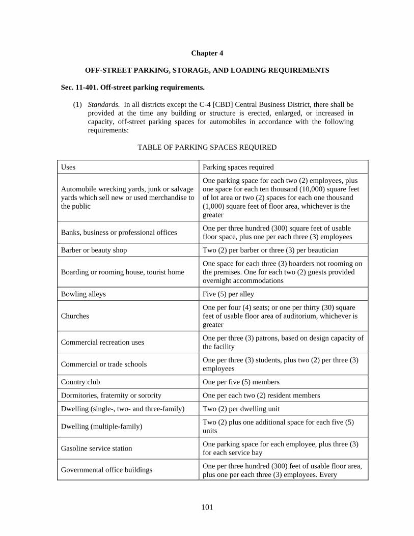
101
Chapter 4
OFF-STREET PARKING, STORAGE, AND LOADING REQUIREMENTS Sec. 11-401. Off-street parking requirements.
(1) Standards. In all districts except the C-4 [CBD] Central Business District, there shall be provided at the time any building or structure is erected, enlarged, or increased in capacity, off-street parking spaces for automobiles in accordance with the following requirements:
TABLE OF PARKING SPACES REQUIRED
Uses Parking spaces required
Automobile wrecking yards, junk or salvage yards which sell new or used merchandise to the public
One parking space for each two (2) employees, plus one space for each ten thousand (10,000) square feet of lot area or two (2) spaces for each one thousand (1,000) square feet of floor area, whichever is the greater
Banks, business or professional offices One per three hundred (300) square feet of usable floor space, plus one per each three (3) employees
Barber or beauty shop Two (2) per barber or three (3) per beautician
Boarding or rooming house, tourist home One space for each three (3) boarders not rooming on the premises. One for each two (2) guests provided overnight accommodations
Bowling alleys Five (5) per alley
Churches One per four (4) seats; or one per thirty (30) square feet of usable floor area of auditorium, whichever is greater
Commercial recreation uses One per three (3) patrons, based on design capacity of the facility
Commercial or trade schools One per three (3) students, plus two (2) per three (3) employees
Country club One per five (5) members
Dormitories, fraternity or sorority One per each two (2) resident members
Dwelling (single-, two- and three-family) Two (2) per dwelling unit
Dwelling (multiple-family) Two (2) plus one additional space for each five (5) units
Gasoline service station One parking space for each employee, plus three (3) for each service bay
Governmental office buildings One per three hundred (300) feet of usable floor area, plus one per each three (3) employees. Every
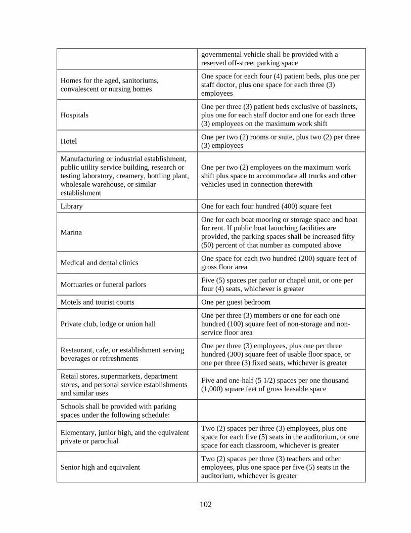
102
governmental vehicle shall be provided with a reserved off-street parking space
Homes for the aged, sanitoriums, convalescent or nursing homes
One space for each four (4) patient beds, plus one per staff doctor, plus one space for each three (3) employees
Hospitals One per three (3) patient beds exclusive of bassinets, plus one for each staff doctor and one for each three (3) employees on the maximum work shift
Hotel One per two (2) rooms or suite, plus two (2) per three (3) employees
Manufacturing or industrial establishment, public utility service building, research or testing laboratory, creamery, bottling plant, wholesale warehouse, or similar establishment
One per two (2) employees on the maximum work shift plus space to accommodate all trucks and other vehicles used in connection therewith
Library One for each four hundred (400) square feet
Marina
One for each boat mooring or storage space and boat for rent. If public boat launching facilities are provided, the parking spaces shall be increased fifty (50) percent of that number as computed above
Medical and dental clinics One space for each two hundred (200) square feet of gross floor area
Mortuaries or funeral parlors Five (5) spaces per parlor or chapel unit, or one per four (4) seats, whichever is greater
Motels and tourist courts One per guest bedroom
Private club, lodge or union hall One per three (3) members or one for each one hundred (100) square feet of non-storage and non-service floor area
Restaurant, cafe, or establishment serving beverages or refreshments
One per three (3) employees, plus one per three hundred (300) square feet of usable floor space, or one per three (3) fixed seats, whichever is greater
Retail stores, supermarkets, department stores, and personal service establishments and similar uses
Five and one-half (5 1/2) spaces per one thousand (1,000) square feet of gross leasable space
Schools shall be provided with parking spaces under the following schedule:
Elementary, junior high, and the equivalent private or parochial
Two (2) spaces per three (3) employees, plus one space for each five (5) seats in the auditorium, or one space for each classroom, whichever is greater
Senior high and equivalent Two (2) spaces per three (3) teachers and other employees, plus one space per five (5) seats in the auditorium, whichever is greater
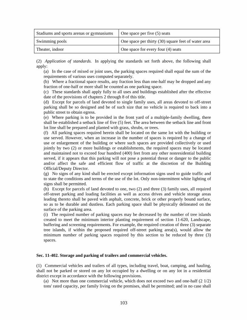
103
Stadiums and sports arenas or gymnasiums One space per five (5) seats
Swimming pools One space per thirty (30) square feet of water area
Theater, indoor One space for every four (4) seats
(2) Application of standards. In applying the standards set forth above, the following shall apply:
(a) In the case of mixed or joint uses, the parking spaces required shall equal the sum of the requirements of various uses computed separately. (b) Where a fractional space results, any fraction less than one-half may be dropped and any fraction of one-half or more shall be counted as one parking space. (c) These standards shall apply fully to all uses and buildings established after the effective date of the provisions of chapters 2 through 8 of this title. (d) Except for parcels of land devoted to single family uses, all areas devoted to off-street parking shall be so designed and be of such size that no vehicle is required to back into a public street to obtain egress. (e) Where parking is to be provided in the front yard of a multiple-family dwelling, there shall be established a setback line of five (5) feet. The area between the setback line and front lot line shall be prepared and planted with grass, shrubs, or trees. (f) All parking spaces required herein shall be located on the same lot with the building or use served. However, when an increase in the number of spaces is required by a change of use or enlargement of the building or where such spaces are provided collectively or used jointly by two (2) or more buildings or establishments, the required spaces may be located and maintained not to exceed four hundred (400) feet from any other nonresidential building served, if it appears that this parking will not pose a potential threat or danger to the public and/or affect the safe and efficient flow of traffic at the discretion of the Building Official/Deputy Director. (g) No signs of any kind shall be erected except information signs used to guide traffic and to state the conditions and terms of the use of the lot. Only non-intermittent white lighting of signs shall be permitted. (h) Except for parcels of land devoted to one, two (2) and three (3) family uses, all required off-street parking and loading facilities as well as access drives and vehicle storage areas leading thereto shall be paved with asphalt, concrete, brick or other properly bound surface, so as to be durable and dustless. Each parking space shall be physically delineated on the surface of the parking area. (i) The required number of parking spaces may be decreased by the number of tree islands created to meet the minimum interior planting requirement of section 11-620, Landscape, buffering and screening requirements. For example, the required creation of three (3) separate tree islands, if within the proposed required off-street parking area(s), would allow the minimum number of parking spaces required by this section to be reduced by three (3) spaces.
Sec. 11-402. Storage and parking of trailers and commercial vehicles. (1) Commercial vehicles and trailers of all types, including travel, boat, camping, and hauling, shall not be parked or stored on any lot occupied by a dwelling or on any lot in a residential district except in accordance with the following provisions.
(a) Not more than one commercial vehicle, which does not exceed two and one-half (2 1/2) tons' rated capacity, per family living on the premises, shall be permitted; and in no case shall
104
a commercial vehicle used for hauling explosives, gasoline, or liquefied petroleum products be permitted. (b) Camping or travel trailer, hauling trailer, or boat trailer are all permitted to be parked on the premises. A camping or travel trailer shall not be parked or stored for more than seventy-two (72) hours unless it is located behind the front building line, nor shall such trailer be occupied permanently while it is parked or stored in any area except in a mobile home park as authorized by this or other ordinances.
(2) In any commercial zone, tractor trailers which are not being used for normal loading or unloading purposes, or for activities directly associated with normal trucking operations, shall not be parked or stored on a lot unless they are located behind the front setback line created by the building located closest to the street right-of-way. Any existing violations shall be brought into compliance within thirty (30) days after [May 2, 1991,] the effective date of this subsection. This subsection is intended to minimize undesirable and unsightly conditions and to ensure compliance with intended advertising regulations. Sec. 11-403. Off-street loading and unloading requirements.
The following rules and regulations shall apply to off-street loading and unloading facilities:
(a) A building whose dominant use is handling and selling goods at retail shall provide one off-street loading and unloading space for buildings up to and including ten thousand (10,000) square feet of floor area, plus one additional space for each additional ten thousand (10,000) square feet of gross floor space. (b) Manufacturing, repair, wholesale, and similar uses shall provide one off-street loading and unloading space for building containing ten thousand (10,000) square feet of floor space plus one space for each forty thousand (40,000) square feet of floor area in the excess of ten thousand (10,000) square feet. (c) Where trailer trucks are involved, such loading and unloading space shall be an area twelve (12) by fifty (50) feet with a fourteen-foot height clearance and shall be designed with appropriate means of truck access to a street or alley, as well as having adequate maneuvering area. (d) All required off-street loading and unloading facilities as well as access drives leading thereto shall be paved with asphalt, concrete, brick or other properly bound surface, so as to be durable and dustless.
105
Chapter 5
SIGNS, BILLBOARDS, AND OTHER ADVERTISING STRUCTURES* Sec. 11-501. General purpose; exemptions. (a) These conditions are established as a reasonable method of regulating advertising structures in order to ensure light, air, and open space; to reduce hazards at intersections; to prevent accumulation of trash; to preclude the establishment of structures which would afford hiding places for activities characterized as criminal; and to protect property values of the entire community.
The regulations for signs, billboards, and other advertising structures are indicated below. The interpretation of nomenclature in this section shall be as defined in section 11-203.
(b) The following signs shall be exempt from regulation under this chapter:
(1) Any public notice or warning required by a valid and applicable federal, state, or local law, regulation, or ordinance; (2) Any sign inside a building, not attached to a window or door, that is not legible from a distance of more than three (3) feet beyond the lot line of the zone lot or parcel on which such sign is located; (3) Works of art that do not include a commercial message; (4) Holiday signs and decoration with no commercial message; and (5) Traffic control signs on private property, such as Stop, Yield, and similar signs, the face of which meet department of transportation standards and which contain no commercial message of any sort. (6) Signs placed upon buses utilized in conjunction with, and authorized by, the Clarksville Transit System. (7) Signs of any kind displayed within the geographic boundaries of, and in conjunction with, public functions, festivals, street fairs or other similar celebrations conducted pursuant to title 5, chapter 10 of this Code.
Sec. 11-502. Regulations applying to all districts. In any zoning district, the following general regulations shall apply:
(1) No sign shall be erected or maintained at any location where, by reason of its position, wording, illumination, size, shape, or color it may obstruct, impair, obscure, interfere with the view of, or be confused with any authorized traffic control sign, signal, or device. (2) No sign shall contain or make use of any word, phrase, symbol, shape, form, or character in such manner as to interfere with, mislead, or confuse traffic. (3) No illuminated sign shall be permitted within twenty-five (25) feet of property in any residential district unless the illumination of the sign is so designed that it does not shine or reflect light onto the property. (4) No business or advertising sign shall be erected to exceed fifty (50) feet in length. No sign shall be erected to exceed the height of the district in which it is located. (5) All outdoor advertising structures, including billboards, shall be erected in conformity with the side and rear yard requirements of the district in which located, and shall be set back
106
from the established street right-of-way line so as not to block the view of an adjacent building. (6) No off-premise advertising sign shall be located in any area designated by the city, county or planning commission as one of scenic beauty and/or scenic route. (7) [Temporary signs.]
a. Temporary signs are prohibited in all areas except in the following cases: Temporary signs not exceeding thirty-two (32) square feet in area, are allowed to advertise drives or events of civic, philanthropic, educational, or religious organizations, provided that said signs are posted only during said drive or no more than thirty (30) days before said event and are removed no more than five (5) days after an event. b. Signs not exceeding twenty-four (24) square feet in area and containing a commercial message are allowed on private property only upon the issuance of a temporary sign permit, which shall authorize the use of such a sign for a specified ten-day period. Only one such permit shall be issued to the same business license holder on the same lot more than once each calendar quarter. The fee for a temporary permit shall be established by the building inspector. Such signs shall not be considered billboards, outdoor advertising devices, or off-premise advertising devices, relative to the prohibition of such structures contained in sections 11-503 through 11-507. c. The following section applies only to the aforementioned allowable temporary signs: temporary signs shall not be erected or otherwise fixed to any pole, tree, stone, fence, building, structure, or any object within the right-of-way of any street. No temporary sign shall be erected at the intersection of any street in such a manner as to obstruct vision or be confused with any authorized traffic sign, signal, or device. All such signs shall be erected in accordance with the provisions of Sections 2302 and 2303 of the Southern Building Code, 1988 Edition.
(8) Except as provided in section (7) above, all temporary signs are prohibited after a period of thirty (30) days from the effective date of this subsection. (9) At any location deemed a safety hazard by the building and codes department, a clear zone of vision shall be established between three and one-half (3 1/2) feet to ten (10) feet above grade level. Sign clearance shall be measured from grade level. (10) Professional signs for home occupations shall comply with the requirements of section 11-503. (11) No rotating sign shall exceed eight (8) rounds per minute (rpm's). No direct beam of light shall revolve. (12) All abandoned signs or signs relating to an abandoned use must be removed within thirty (30) days after abandonment. Removal is the responsibility of the owner of the sign. (13) All signs shall be constructed, connected, operated and maintained according to the specifications of the Standard Building Code. (14) All signs shall be maintained in a good state of repair. Painted faces or structural members shall be repainted whenever peeling or fading occurs. Neon tubes, lamps, ballasts, and transformers shall be kept in a good state of repair and in safe condition. Open sign cabinets are prohibited. Open cabinets shall be repaired by installing sign faces consisting of a panel material that is approved by the Department of Building Codes or other designated department or official. The city may order the removal of any sign which becomes a public hazard due to lack of maintenance or repair. (15) Signs may be illuminated provided the illumination is effectively shielded so as to prevent beams or rays of light from being directed at any portion of the traveled ways of any road or street. Illumination which is of such intensity and brilliance as to cause glare or to impair the vision of the driver of any motor vehicle or which otherwise interferes with any driver's operation of a motor vehicle is prohibited.
107
(16) No sign shall be allowed if the changeable copy area of the sign exceeds eighty (80) percent of the total sign area. (17) (a) Except as herein provided in subsection (17) (b) below, upon the effective date of Ordinance No. 13-1996-97, no new off-premise advertising structures shall be erected within the city limits of the City of Clarksville. Any off-premise advertising structure which is legally permitted on the effective date of Ordinance No. 13-1996-97 shall be considered to be nonconforming and is subject to the following regulations:
(i) The maximum area for any one sign face shall be seven hundred (700) square feet on all interstate and controlled access highways, and four hundred (400) square feet on all other streets of the city of Clarksville, plus a maximum of thirty (30) percent additional for embellishments. Embellishments shall be considered to be any type of border or decorative trim. The thirty (30) percent factor shall be calculated proportionally for each individual sign face in question. The total sign face area may not exceed the maximum square footage as regulated above; however, sign faces may be placed back-to-back or v-type at a thirty-degree angle or less. (ii) Sign face: The total area of a surface used to convey the message. (iii) The maximum sign face height shall be thirty (30) feet and the maximum sign face length shall be sixty (60) feet, inclusive of any border and trim, but excluding ornamental base or apron support and other structural members. (iv) On all highways or streets, including interstate highways and controlled access highways, no two (2) structures shall be spaced less than one thousand (1,000) lineal feet apart on the same side of such highway or street. The minimum distance between sign structures shall be measured between points on each structure closest to the other, projected perpendicular to the nearest edge of the pavement (or traveled portion of such right-of-way). (v) No two (2) structures shall be placed on any highway or street (including interstate highways and controlled access highways) spaced less than five hundred (500) feet apart in any direction. The minimum distance shall be measured along a straight line between the point on each structure closest to the other. vi) Outdoor advertising structures shall not exceed fifty (50) feet in height above the roadway grade level to which the sign is oriented.
(b) Notwithstanding the provisions of subsection 17(a) above, the City Council, with the permission of the concerned permit holder, may approve by resolution the relocation of any existing off-premise advertising structure when in the best interest of the City, provided that the replacement off-premise advertising structure complies with all City ordinance and other general law requirements pertaining to such structures, and provided further that a site plan application has been previously submitted by the permit holder and approved by the Regional Planning Commission, and that the Clarksville Department of Building and Codes has recommended approval of a building permit for the replacement off-premise advertising structure. The employment of the provisions of this subparagraph are solely at the election of the City and for the sole benefit of the City and shall not be construed to grant any permit holder the right to relocate any off-premise advertising structure without City Council approval, or to seek relief hereunder upon their own motion. (18) Banners shall be allowed only when attached at all corners to the principal structure, including any enclosed area containing merchandise for sale and attached to the principal structure. (19) Pennants/streamers shall maintain a ten-foot clearance from the bottom of the pennants/streamers to the ground. (20) Strings of lights shall be required to have electrical permits, be inspected, and approved by UL or a major testing laboratory. Strings of lights must also meet the ten (10) foot minimum clearance required for pennants and streamers.
108
(21) [Public signs.] a. No signs shall be allowed in the public right-of-way, except for the following:
1. Public signs erected by or on behalf of a governmental body to post legal notices, identify public property, convey public information, and direct or regulate pedestrian or vehicular traffic. 2. Bus stop signs erected by a public transit company. 3. Informational signs of a public utility regarding its poles, lines, pipes, or facilities. 4. Emergency warning signs erected by a governmental agency, a public utility company, or a contractor doing authorized or permitted work in the public right-of-way. 5. Sidewalk signs as permitted in Section 11-510.
b. Any sign not specified above which is installed or placed on public property, except in conformance with the requirements of this section, shall be forfeited to the public and subject to immediate confiscation without notice to the owner. In addition to other remedies hereunder, the city shall have the right to recover from the owner or person placing such sign the full costs of removal or disposal of such sign.
(22) Nothing in this ordinance shall prohibit the use of advertising signs within the confines of athletic facilities, civic halls, or within the confines of parks in conjunction with sporting events. Such allowance shall be at the discretion of the Building and Codes Department. (23) Address signs, not more than one for each lot frontage or one for each principal entrance of the building and not exceeding seventy-two (72) square inches in surface area, showing only the numerical address designations of the premises upon which they are situated, are required. The area of such signs shall not be used in calculating any maximum area limitations on signage containing herein. (24) If it is determined by the appropriate department or building official or such official's designee that any owner of record of real property has violated the provisions of this chapter, or permitted violations of this chapter to occur on their property, the appropriate department or building official or other designated official shall provide notice to the owner of record of the violation and ordering the immediate removal of any sign in violation of the provisions of this chapter in order to remedy the condition as provided by state law. The notice shall be given by United States mail, addressed to the last known address of the owner of record. The notice shall state that the owner of the property is entitled to a hearing. The notice shall be written in plain language and shall also include, but not be limited to, the following elements:
a. A brief statement of this section which shall contain the consequences of failing to remedy the noted condition. b. The person, office, address, and telephone number of the department or person giving notice. c. Cost estimate for remedying the noted condition which shall be in conformity with the standards of cost in the community. d. A place wherein the notified party may return a copy of the notice indicating the desire for a hearing. If the person fails or refuses to remedy the condition within thirty (30) days after receiving the notice, the appropriate department or building official or other designated official shall immediately cause the condition to be remedied or removed at a cost in conformity with reasonable standards and the cost thereof shall be assessed against the owner of the property. The city may collect the costs assessed against the owner through an action for debt filed in any court of competent jurisdiction. The city may bring one action for debt against more than one or all of the owners of properties against whom
109
such costs have been assessed, and the fact that multiple owners have been joined in one action shall not be considered by the court as a misjoinder of parties. The appropriate department or building official or other designated official may make any rules and regulations necessary for the administration and enforcement of this section. A hearing shall be provided upon request of the person aggrieved by the determination made pursuant to this chapter. A request for a hearing shall be made within ten (10) days following the receipt of the notice issued pursuant to this chapter. Failure to make the request within this time shall without exception constitute a waiver of the right to a hearing. In addition to the costs incurred by the city to remedy the condition, an administrative fee of one hundred fifty dollars ($150.00) shall be assessed to any owner of property who fails to remedy the condition for which notice was given to defray the cost to the city to administer this regulatory program.
(25) Parcels sharing a recorded travel easement that has been approved by the Regional Planning Commission, shall share one (1) common freestanding sign per public right-of-way frontage and is subject to the following regulations: (a) The common sign shall not exceed height limitations specified elsewhere in this chaper
and shall not exceed twenty (20) feet in length; (b) Each parcel shall be allowed one nameplate on each side per common sign; (c) Such signs shall be maintained by property owners' association established by the
recorded travel easement; (d) A sign easement shall be shown on the final recorded travel easement plat and approved
site plan. (e) One sign may be allowed on the common sign for each parcel sharing the approved travel
easement.
Sec. 11-503. Residential districts. In residential districts, the following regulations shall apply: (1) For single-family, two- and three-family, and multiple-family dwellings, nameplates not to exceed two (2) square feet in area shall be permitted for each dwelling unit. The nameplate shall indicate nothing other than name and/or address of occupants, premises, or announcement of boarders or roomers. In such residential districts, unlighted, freestanding permanent or temporary signs of six (6) square feet in area or less are permitted. The use of such signs to advertise any commercial enterprise not permitted and actually conducted on the same lot is prohibited. (2) Reserved. (3) For multiple-family and group dwellings, identification signs, not to exceed twelve (12) square feet in area, shall be permitted. The sign shall indicate nothing other than name and/or address of premises and name of the management. (4) For all permitted uses not listed in this section, signs not to exceed thirty (30) square feet in area shall be permitted. Such signs shall not be located in a manner so as to obscure or impair vision of persons operating vehicles entering or leaving the premises.
110
(5) Signs permitted in subsections (3) and (4) shall be limited to one sign per street frontage. (6) Identification signs containing only the name of the public use or institution shall be permitted but shall not exceed one hundred fifty (150) square feet of area. (7) Flashing or intermittent illumination is prohibited. (8) Subdivisions may erect no more than two (2) permanent identification signs at subdivision entrances on every major connector street entering the subdivision, with an aggregate maximum square footage not to exceed sixty-four (64) square feet. Such signs may identify the name of the subdivision, the primary developer or builders of dwelling units in the subdivision; however, the use of such signs to advertise any commercial enterprise is prohibited. Sec. 11-504. OP and O-1 districts. In an OP office and professional district and in an O-1 office, medical, institutional, and civic district, the following regulations shall apply:
(1) For residential uses permitted, the regulation of signs shall be the same as in the residential regulations above. (2) The total area of all signs on each parcel shall not exceed one square foot of surface area for each one linear foot of lot adjoining a public street or permanent easement, as regulated in subsection 11-612, (4)(f). (3) No signs, except "low profile signs," may be placed within twenty (20) feet of the front property line and shall comply with all rear and side yard setback requirements. (4) "Low profile signs" are signs which do not exceed three and one-half (3 1/2) feet in height. These signs may be placed up to the front property line, provided they are placed outside of any street right-of-way and so as to not obstruct vision for moving traffic, as determined by the building official. Normal side yard setbacks must be met. (5) Signs shall not exceed fifteen (15) feet in height, except those attached to the face of the building. Signs attached to buildings shall not extend above the roof line. (6) Flashing or intermittent illumination signs are prohibited.
Sec. 11-505. Commercial and shopping center districts. In commercial and shopping center districts, the following regulations shall apply:
(1) There shall be permitted for public uses, utilities, hospitals, and clinics bulletin boards not exceeding forty (40) square feet in area. (2) Billboards and other outdoor advertising structures are permitted in C-2, C-4 and C-5 commercial districts. (3) No sign shall exceed, from the ground elevation on which it is placed, thirty-five (35) feet in height in the C-1 zone and fifty (50) feet in height in the C-2, C-3, C-4 and C-5 zones with the exception of signs as controlled in the following item (5). (4) In the C-4 Highway Interchange District, no sign shall exceed from the ground elevation on which it is placed, one hundred (100) feet in height when placed at the rear of the property and when such sign is located no further than two thousand five hundred (2,500) feet from the center point of the intersection of the Interstate Highway and its adjoining roadway.
111
Sec. 11-506. H-1 district. In an H-1 historical district, the following regulations shall apply:
(1) Informational signs may be displayed in connection with such use, but the total area of each sign shall not exceed nine (9) square feet and signs may have indirect lighting. (2) Flashing or intermittent illumination is prohibited.
Sec. 11-507. Industrial and manufacturing districts. In industrial or manufacturing districts, the following regulations shall apply:
(1) In an M-3 planned industrial district, business signs shall be permitted not exceeding two (2) square feet per one lineal foot of street frontage. Such signs shall be located not closer than one-half the required setback from all property lines. (2) Flashing or intermittent illumination is prohibited.
Sec. 11-508. Reserved. Sec. 11-509. CBD central business district. In the CBD district, the following regulations shall apply, and if the same subject matter is regulated elsewhere in the title, the more restrictive regulation shall apply:
(1) The total square footage for all wall and awning signs is one square foot per linear foot of the structure's primary entrance frontage, and shall not exceed ten (10) percent of the surface to which it is affixed, whichever is lesser. (2a) All projecting signs shall maintain a clear height of at least seven (7) feet above the finished elevation of the sidewalk. Such sign shall not project upon or over any sidewalk for more than four (4) feet, and shall not extend over a public street. For signs within (7) seven to ten (10) feet of the finished elevation of the sidewalk, the size of the projecting sign shall not exceed six (6) square feet in area. For signs within ten (10) to twelve (12) feet of the finished elevation of the sidewalk, the size of the projecting sign shall not exceed twelve (12) square feet in area. For signs twelve (12) feet and above the finished elevation of the sidewalk, the size of the projecting sign shall not exceed sixteen (16) square feet in area. (2b) All awnings shall maintain a clear height of seven (7) feet above the finish elevation of the sidewalk and shall not project over any sidewalk more than six (6) feet, and shall not extend over a public street. (3) After the effective date of this ordinance, all new signs for which a permit is required must be reviewed and approved by the central business improvement district's design review board, upon a determination that the proposed signage is in conformance with the design guidelines as adopted by the downtown district partnership, or any amendment thereto. (4) In addition to all wall and awning signs, all window signs shall not exceed more than twenty-five (25) percent of the total window area of the primary entrance frontage.
112
(5) Except as permitted in Section 11-510, all freestanding signs shall not exceed thirty-two (32) square feet and shall not encroach upon any public right-of-way. (6) Flags, as defined and authorized in section 11-203(7.1) of the City Code, shall have a seven-foot clearance from the finish elevation of the sidewalk and shall not exceed more than fifteen (15) square feet each. No principal structure shall be allowed more than two (2) flags. (7) Banners shall be allowed only when attached at all corners to the principal structure and shall obtain a temporary sign permit, which shall authorize the use of such a banner for a specified ten-day period. Banners shall provide for a ten-foot clearance and shall have only one such permit issued to the same business license holder per calendar quarter. The fee for a temporary permit shall be established by the building inspector. (8) Entrance and exit signs, for parking or directions, shall be four (4) square feet or less. (9) Signs must be illuminated in a manner that does not impair the visibility of motorists or pedestrians. Light sources shall be shielded to minimize the visibility of lamps and prevent overspray beyond the sign perimeter. (10) Reserved. (11) Exposed bulb signs are prohibited. No flashing, chasing, running or sequential lighting is permitted. (12) Except as provided in Section 11-510, all portable signs are prohibited. (13) With the exception of projecting signs and awnings as described in this section and except as provided in Section 11-510, no private advertising signs shall be placed on or overhanging the public right-of-way. (14) No private sign shall be attached to a utility pole. (15) All pennants/streamers are prohibited. Provided, however, that any business use continuously displaying pennants or streamers on or before July 1, 2001, may continue to display such pennants/streamers in accordance with Title 11, Chapter 5, on all parcels employed for such business use. (16) Address signs, not more than one for each lot frontage or one for each principal entrance of the building and not exceeding seventy-two (72) square inches in surface area, showing only the numerical address designations of the premises upon which they are situated, are required. The area of such signs shall not be used in calculating any maximum area limitations on signage contained herein. (17) One sign not to exceed forty (40) square feet in area, indicating the name of the contractors, engineers, and/or architects of a project, during a construction period for which a building permit is required, is allowed. (18) (a) Signs identifying or advertising relocated, permanently closed or non-existent businesses shall not be permitted. Owners may maintain legally permitted sign boards, enclosures and supports by removing or "painting out" obsolete lettering and logos to match the sign background for a uniform "blank" appearance. Open sign enclosures shall not be permitted. (18) (b) Signs that are not properly maintained, deteriorated signs and abandoned signs shall be removed in their entirety. (19) Preservation of the cultural and historic character of downtown Clarksville is a valid object of zoning by the Clarksville City Council. Therefore, for the purpose of maintaining the historical character of the Clarksville Central Business District, the following signs shall be exempt from the regulations contained herein:
(a) Signs which are a part of the original construction of any building constructed before 1970; (b) Signs which have been displayed continuously before 1970 at a location within the Central Business District.
113
Section 11-510. Downtown Sidewalk Signs.
Non-residential properties located within the shaded area defined in Figure 510-1 may display sidewalk signs under the following provisions: (1) One sidewalk sign is permitted for each business. Multiple signs are allowed
for multi-tenant buildings. (2) Sidewalk signs may be displayed only during the business hours of operation. (3) Sidewalk signs must be placed outside of required Americans with Disabilities Act
(ADA) walkways, outside of any required exits and/or entrances, and outside driveways.
(4) The maximum size of each display face of a sidewalk sign is six (6) square feet. (5) The maximum height of a sidewalk sign is 36 inches, as measured above the
sidewalk, and the maximum width is 24 inches. (6) Prior to placement, any proposed sidewalk sign design must be approved by the
Downtown District Partnership Design Review Board.
(7) The owner shall propose methods to care for signs during windy weather to ensure the sign does not blow over, block walkways, and/or interfere with pedestrian or vehicular traffic. Measures may include approved weighting material or removal during such conditions.
(8) Sidewalk signs may be allowed in the public right-of-way if the proposed location does not inhibit the free flow of pedestrian or vehicular traffic and meets the provisions of subsection (3) above.
114
Chapter 6
SUPPLEMENTARY REGULATIONS AND MODIFICATIONS Sec. 11-601. Cemeteries. The following regulations apply to cemeteries in zone districts where such uses are permitted on review:
(1) The site proposed for a cemetery shall not interfere with the development of a system of collector and larger streets in the vicinity of such site. In addition, such site shall have direct access to a thoroughfare. (2) No cemetery shall be established on a site containing less than twenty (20) acres. (3) All other structures except permanent monuments including, but not limited to, mausoleum, mortuary, or maintenance building shall be set back not less than fifty (50) feet from any property line or street right-of-way line. (4) All graves or burial lots shall be set back not less than twenty-five (25) feet from any property line or street right-of-way line. (5) All required yards shall be landscaped and maintained.
Sec. 11-602. Drive-in theaters. The following standards shall apply for drive-in theaters:
(1) The site must have access to a major public road. (2) The screen of a drive-in theater shall be placed a minimum of one hundred (100) feet from the public right-of-way and be located so as to be hidden from the view of traffic contiguous to the entrance and exits of the site. (3) The ingress and egress from the highway shall be designed to permit only one-way traffic. (4) Vehicle standing space shall be provided between the ticket office and the public right-of-way line, for patrons awaiting admission, equal in quantity to not less that twenty (20) percent of the capacity of the theater. (5) All ground areas accessible to vehicles shall be treated with suitable material to prevent the formation of dust. (6) An opaque wall or fence shall be provided of adequate height to screen the patrons and cars in attendance at the drive-in theater from the view of surrounding properties. (7) All parking areas and access ways shall be adequately lighted; provided, however, that such lighting shall be shielded to prevent any glare or reflection onto a public street or onto neighboring properties. (8) The vehicular approach to the drive-in theater site from the public thoroughfare or highway should be so designed that uncontrolled left-hand turns from the public thoroughfare or highway to the site are eliminated or reduced by either a frontage roadway or other suitable means. (9) Sight distances at all points of ingress and egress shall be not less than one thousand (1,000) feet, except where a traffic signal light is installed at the entrance or exit of the site.
115
Sec. 11-603. Day care facilities. For the purpose of this ordinance [title], day care facilities are classified into two (2) types as defined elsewhere in this ordinance [title]. The two (2) types are the family day care homes, further divided into small family day care homes and large day care homes, and child care facilities. In the zone districts where such uses are permitted on review by the board of zoning appeals, the following standards for large family day care homes and child care facilities shall apply: (1) Large family day care homes:
(a) The required lot size, yard, and bulk regulations of the district shall apply. No variances shall be permitted for lots on which such use is to be located. (b) All public utilities and sanitary sewer shall be available and connected to the site. (c) The facility shall meet the requirements of the Tennessee Department of Human Services pertaining to day care. (d) [Reserved.] (e) Fencing, screening, and landscaping shall be provided as required by the building department to protect the surrounding area. (f) One accessory off-street parking space for each attendant or teacher, plus one off-street loading space for each six (6) children accommodated shall be provided. (g) A site plan shall be submitted to the building department in conjunction with the application for review.
(2) Child care facilities:
(a) The required lot size, yard, and bulk regulations of the district shall apply. No variances shall be permitted for lots on which such use is to be located. (b) In commercial and industrial districts where the property in question is adjacent to a residential district, the side and rear yard requirements of the adjoining residential district shall apply. (c) All public utilities and sanitary sewers shall be available at and connected to the site. (d) The facility shall meet the requirements of the Tennessee Department of Human Services pertaining to day care. (e) [Reserved.] (f) Fencing, screening, and landscaping shall be provided as required by the building department to protect the surrounding area. (g) Two (2) accessory off-street parking spaces for each attendant or teacher, plus one off-street loading space for each six (6) children accommodated shall be provided. (h) Special passenger loading and unloading facilities shall be provided on the same zone lot for vehicles to pick up or deliver children. Such facilities shall provide for driveways that do not require vehicle to back out onto a public street. (i) A site plan shall be submitted to the building department in conjunction with the application for review.
116
Sec. 11-604. Mobile home parks. (1) Location.
(a) The location of mobile home parks, as defined herein, shall be approved by the board of zoning appeals. (b) Mobile home parks are permitted to be located in the R-4 multiple-family district. (c) The boundary of the park must be at least one hundred (100) feet from any permanent residential building located outside the park, separated therefrom by a natural or artificial buffer zone of at least fifty (50) feet.
(2) Mobile home park standards. The following property development standards shall apply for all mobile home parks hereinafter established or altered:
(a) No parcel of land containing less than five (5) acres and less than fifteen (15) mobile home spaces, available at the time of first occupancy, shall be used for a mobile home park; however, the plans submitted for approval, as required under application for permit, shall be designed for a minimum of twenty-five (25) mobile home units. (b) The mobile home park shall be subject to the density provisions in which it is located; provided, however, there shall be not less than three thousand (3,000) square feet of lot area for each space provided on the site. This space ratio shall include access roads, automobile parking, accessory building space, and recreation area. (c) The mobile home park shall be located on a well drained site, shall be so located that its drainage will not endanger any water supply, and shall be in conformity with all applicable health and sanitation regulations in force by the Montgomery County Health Department. (d) Yards:
(i) Each mobile home park shall have a front yard of twenty-five (25) feet extending for the full width of the parcel devoted to that use. (ii) Each mobile home park shall have a rear yard and a side yard on both sides of the parcel devoted to that use of not less than ten (10) feet. (iii) Where a side or rear yard abuts a street, the yard shall not be less than twenty-five (25) feet and all yards shall be landscaped and maintained.
(e) No building or structure erected or stationed in the park shall have a height greater than one story or fifteen (15) feet, except a management office, which may have a maximum height of thirty (30) feet. (f) A mobile home park shall be entirely enclosed, exclusive of driveways, at its external boundaries by a solid wall, fence, or evergreen hedge not less than four (4) feet in height. (g) Each mobile home park shall be permitted to display on each street frontage, one identifying sign of a maximum size of twelve (12) square feet. The sign shall contain only the name and address of the mobile home park and may be lighted by indirect lighting only. (h) Each mobile home space shall be of sufficient size that, in addition to the trailer, the following areas shall be provided.
(i) Each mobile home space shall be at least thirty (30) feet wide and sixty (60) feet deep, and such space shall be clearly defined by permanent markers. (ii) There shall be a front yard setback of at least ten (10) feet from all access roads within the mobile home park. (iii) Mobile homes shall be so harbored on each space that there shall be at least fifteen (15) feet clearance between mobile homes or any attachments thereto. No mobile home shall be located closer than twenty (20) feet from any building within the park.
117
(iv) There shall be at least one paved off-street parking space for each trailer space which shall be on the same site or located in grouped parking bays specifically designed for such purpose close to the site served. (v) Each mobile home space shall be provided with a paved patio or wooden deck of at lease one hundred (100) square feet, exclusive of any other walkways or parking spaces; and may provide a metal storage locker or locker fabricated of some suitable material such as concrete blocks or brick, but shall not contain wood siding. Storage lockers may be located in locker compounds established in the rear of the mobile home spaces. Such lockers shall be located at least fifteen (15) feet from trailer coaches. (vi) A docking pad containing a minimum of four (4) inches of compacted gravel, or other suitable pavement material, shall be provided for each trailer space. (vii) All mobile homes shall be properly secured to withstand severe weather conditions.
(3) General provisions.
(a) There shall be established and maintained within each park an automobile parking area for the use of guests. The number of parking spaces within the area shall be equal to one for every four (4) trailer sites. (b) Access roads within a mobile home park shall be paved to a width of not less than twenty (20) feet. Where access roads are paved to a width of twenty-eight (28) feet or more, the required off-street parking spaces shall be waived. (c) Each trailer court that accepts a dependent trailer for parking shall be provided with one or more service buildings complying with state and local laws and as approved by the health officer and building inspector. (d) Walkways not less than two (2) feet wide shall be provided from the mobile home spaces to service buildings. (e) Each mobile home space shall be provided with a connection to a sanitary sewer line or to a sewer system approved by the health department. (f) An accessible, adequate, safe, and potable supply of water approved by the health officer shall be provided in each mobile home park. (g) Refuse storage, collection, and disposal shall be in conformity with the laws and regulations prescribed by the health department. (h) There shall be provided a park and recreation area having a minimum of one hundred fifty (150) square feet for each mobile home space. Areas shall be consolidated into usable areas with minimum dimensions of not less than thirty (30) feet. (i) Each mobile home park containing more than five (5) mobile home spaces shall be provided with a management office and such service buildings as necessary to provide facilities for mail distribution, storage space for supplies, maintenance materials and equipment and coin-operated laundry facilities for tenants only; provided, however, persons or corporations owning or operating more than one mobile home park may provide a management office and related facilities at a central location on the premises near one of the parks so established. Such office may be contained in a residence, mobile home, or in a separate office building. (j) Prefabricated portable attachments or awnings may be attached to or become a part of any mobile home. No permanent addition of any kind shall be built onto, nor become a part of any trailer coach. Complete skirting of mobile homes may be required by the park owner, but such skirting shall not permanently attach the trailer to the ground. (k) Mobile homes shall not be used for commercial, industrial, or other nonresidential uses within the mobile home park, except for customary home occupations as regulated in section 11-607 and with the permission of the board of zoning appeals.
118
(4) Reserved. (5) Application for permits.
(a) An application for a permit to establish a mobile home park shall be as regulated hereunder and as in sections 68-24-101 through 68-24-120, Tennessee Code Annotated. (b) The application for a permit shall be filed with and issued by the Montgomery County Health Department. Each application shall be accompanied by three (3) copies of the plot plan drawn to a scale no smaller than one inch equals one hundred (100) feet. (c) Such copies shall be reviewed and approved by the planning commission, the board of zoning appeals, the health department, and the building inspector. The following information shall be submitted:
(i) The location and legal description of the proposed mobile home park; (ii) Plans and specifications of all buildings, improvements, and facilities constructed or to be constructed within the mobile home park; (iii) The proposed use of buildings shown on the site; (iv) The location and size of all mobile homes spaces; (v) The location of all points of entry and exit for vehicles and internal circulation pattern; (vi) The location of all landscaping to be provided; (vii) The location of all lighting to be provided; (viii) The location of all walls and fences and the indication of their height and materials of construction; (ix) The location of all off-street parking facilities; (x) Such other architectural and engineering data as may be required to permit the health officer, board of zoning appeals, and building inspector to determine if the provisions of this section are being complied with.
(d) A time schedule for development shall be prepared with shall demonstrate the applicant's readiness and ability to provide the proposed services. The time shall be for a period of not more than one year.
(6) Additions or alterations. Any additions or alterations to existing mobile home parks or parks hereinafter established shall be in conformity with the provisions of chapters 2 through 8 of this title. (7) Conformance.
(a) Every mobile home park in existence upon the effective date of the provisions of chapters 2 through 8 of this title may be maintained and operated for an indefinite period without being subject to the provisions hereof; provided, however, that such parks comply with the applicable health regulations and specifications in force and as regulated by sections 68-24-101 through 68-24-120, Tennessee Code Annotated. Failure to make the existing park conform fully to such provisions and specifications shall be due cause for the revocation of permit. (b) All mobile home parks created or established after the effective date of chapters 2 and 8 of this title shall conform to the specifications and requirements as set forth herein.
(8) Supervision. The owner of permittee, or a duly authorized attendant or caretaker, shall be in charge at all times to keep the mobile home park, its facilities and equipment in a clean, orderly, sanitary condition. The attendant or caretaker shall be answerable, with the licensee or permittee,
119
for the violation of any provision of chapters 2 through 8 of this title to which the licensee or permittee is subject. (9) Maintenance of register. Every mobile home park owner or operator shall maintain a register containing a record of all trailer coaches and occupants using the trailer court. Such register shall be available to any authorized person inspecting the court, and shall be preserved for the period required by the health officer. Such register shall contain (1) the names and addresses of all trailer coach occupants stopping in the court, (2) the make, model and license number of each motor vehicle, and (3) the dates of arrival and departure of each trailer coach. (10) Revocation of permit. The health officer may revoke any permit to maintain and operate a park when the permittee has been found guilty by a court of competent jurisdiction of violating any provision of chapters 2 through 8 of this title or sections 68-24-101 through 68-24-120, Tennessee Code Annotated. After such conviction, the permit may be reissued if the circumstances leading to convicting have been remedied and the park is being maintained in full compliance with the law.
Sec. 11-605. CBD central business district residential usage. (1) Purpose.
(a) Residential use is permitted for the purpose of aiding in the revitalization of the central business district by encouraging the development of underutilized properties and buildings. (b) It is further the purpose of this section to promote the development of needed residential units in a manner that creates decent, safe, and suitable living environments. (c) Finally, it is the purpose of this section to promote additional demand for CBD services and facilities through creation of nearby user population.
(2) CBD residential standards. The requirements of Section 11-312 (5) a shall apply.
(3) Off-street parking. Provisions of off-street parking shall be encouraged but not mandated. Applicants shall show evidence of lease or ownership agreements for the parking spaces as required in section 11-401. (4) General provisions.
(a) Refuse storage, collection, and disposal shall be in conformity with the laws and regulations prescribed by the Montgomery County Health Department. (b) All new construction, reconstruction, and remodeling shall conform to all building, housing, and fire codes as adopted by the City of Clarksville.
(5) Application for permits.
(a) The application for a permit shall be filed with and issued by the building official. Each application shall be accompanied by three (3) copies of all plans and specifications drawn to a scale no smaller than one-fourth inch equals one foot. (b) Such copies shall be reviewed and approved by the building inspector.
(i) The location of the units and legal description of the proposed residential lot. (ii) Plans and specifications for all buildings, improvements, and facilities constructed, remodeled, or to be constructed or remodeled on the proposed site.
120
(iii) The proposed use of all areas on the site and within the buildings. (iv) The location of all required parking spaces as associated with the development. (v) Plans for storage and disposal of all immediate and future solid waste as generated by the development. (vi) Any other such architectural and engineering data as may be required to permit the building inspector and the fire prevention officer to determine if the provisions of this section are being followed.
(c) A time schedule for development shall be prepared which shall demonstrate the applicant's readiness and ability to provide the proposed services. The time shall be for a period of not more than one year.
Sec. 11-606. Automobile wrecking and junkyards. Because of the nature and character of their operation, automobile wrecking and salvage yards, junkyards, and similar uses of land can have a decidedly detrimental effect upon surrounding properties. Salvage and wrecking yards tend to create problems of noise, dust, traffic, and health hazards and may adversely affect property values by their general appearance. The following standards shall be used as a guide in evaluating whether proposed land uses, such as those outlined herein, will have properly minimized their objectionable characteristics. (1) License required. All salvage yards must be licensed. An application to establish a salvage yard in Clarksville shall be filed with the planning commission and approved by the board of zoning appeals. For the purpose of this section, junkyards, automobile wrecking yards, and other similar operations shall be known as "salvage yards." (2) Location. Because of the tendency for salvage yards to promote the breeding of vermin, no such operation shall be permitted closer than five hundred (500) feet from any established residential district. All storage of three (3) or more unlicensed abandoned vehicles and salvaged vehicles must be in an approved and licensed salvage yard. All abandoned and junked motor vehicles and other similar large salvage articles that can be seen from any public right-of-way shall be moved to a licensed salvage yard within one year of the effective date of the provisions of chapters 2 through 8 of this title. (3) Screening. All outdoor storage of salvage yards or junk yards shall be conducted entirely within an area which is screened by natural objects, plantings, fences, or other appropriate means so as not to be visible from the main traveled roads or way of the system, or they will otherwise be removed from sight. Storage outside such screening is expressly prohibited. Such screening shall be properly maintained in good condition. (4) Ingress and egress. The maximum number of vehicular access driveways for salvage yards having frontage on a state or federal highway shall be as regulated by the State of Tennessee, Department of Highways. The maximum number of vehicular access driveways for salvage yards having frontage on a city street shall be as regulated by the city council. (5) Submission of plans. All persons operating or intending to operate salvage yards must apply to and submit plans to the planning commission for review and recommendation for approval by the city council. All salvage yards in existence upon the effective date of the provisions of chapters 2 through 8 of this title shall have two (2) years from that date to be licensed and be in compliance with all provisions contained herein.
121
(6) Off-street parking. As regulated in section 11-401. Sec. 11-607. Customary home occupations. This section defines customary home occupations and prescribes the conditions under which such occupations shall be permitted. (1) A customary home occupation is a gainful business or profession conducted by members of a family residing on the premises, conducting entirely within the dwelling. In connection with a home occupation, no stock in trade shall be displayed outside the dwelling, and no alteration of any building shall indicate from the exterior that the building is being utilized in whole or in part for any purpose other than a residential unit, including permitted accessory buildings. (2) The following occupations, subject to the above paragraph, are permitted as customary home occupations:
(a) Antique sales; provided, however, that outdoor display is prohibited; (b) Artist, sculptor, and similar occupations of the arts; (c) Dressmaker, milliner, seamstress, tailor, interior decorator; (d) Professional office of a physician, realtor, dentist, lawyer, engineer, architect, photographer, or accountant within a dwelling occupied by same, provided that no more than two (2) paid assistants shall be employed; (e) Teaching, including tutoring, musical instruction, or dancing; (f) Any other similar use which the board of zoning appeals deems to be a home occupation.
(3) Prohibited: Dancing institutions and band instrument instructions in groups, tea rooms, tourist homes, convalescent homes, mortuary establishments, animal hospitals, and stores, trades, or business of any kind not included herein or authorized by the board of zoning appeals. Sec. 11-608. Temporary use. The regulations contained in this section are necessary to govern the operation of certain transitory or seasonal uses, nonpermanent in nature. (1) Application for a temporary use permit shall be made to the building official and shall contain the following information:
(a) A survey or legal description of the property to be used, rented, or leased for a temporary use, including enough information to specifically identify the property; (b) A description of the proposed use; and (c) Sufficient information to determine the yard requirements, setbacks, sanitary facilities, and availability of parking space to service the proposed use.
(2) The following uses are classified as temporary uses and shall be subject to the specific regulations and time limits which follow and to the regulations of any district in which such use is located:
(a) Carnival or circus. As regulated by city ordinance; provided, however, that the erection of temporary structures in conjunction with public functions, festivals, street fairs or other
122
similar celebrations being conducted pursuant to section 5-1002 shall be in accordance with regulations imposed by the agency designated in section 5-1002(2). (b) Christmas tree sale. In any commercial or industrial district, a temporary use permit may be issued for the display and open lot sales of Christmas trees, but such permit shall be issued for a period of not longer than thirty (30) days. (c) Temporary buildings or mobile trailer units. In any district, a temporary use permit may be issued for a contractor's temporary office and equipment sheds incidental to a construction project. However, such office or shed shall be removed upon completion of the construction project. (d) Real estate sales office. In any district a temporary use permit may be issued for a temporary real estate sales office in any new subdivision. Such office may be temporarily contained in a dwelling unit or in a portable unit such as a trailer. Such use shall be discontinued after all real property in the subdivision has been sold. (e) Religious tent meeting. In any nonresidential district, a temporary use permit may be issued for a tent or other temporary structure to house religious meetings. The permit shall be valid for not more than thirty (30) days, but is subject to renewal prior to the terminal date. (f) Seasonal sale of farm products. In any district a temporary use permit may be issued for the sale of farm products grown on the premises. The sales space shall be of portable or sectional construction, and shall not exceed an area of three hundred (300) square feet and the stands shall be removed when not in use. A permit shall be valid for not more than four (4) months per year. A temporary structure used for this purpose shall be set back from all public rights-of-way a distance of not less than fifteen (15) feet. (g) Prohibited. Sales of fireworks.
Sec. 11-609. Tents.
No tents shall be used, erected, or maintained as permanent living quarters for more than thirty (30) days. Tents used in commercial or industrial districts shall be of a temporary nature, as for the protection of surplus goods, for the housing of seasonal farm produce sales, or as temporary uses incidental to an established business or industry. Sec. 11-610. Fallout shelters.
Fallout shelters are permitted as principal or accessory uses and structures in any district, subject to the building setbacks and yard requirements of the district established therein. These shelters may contain or be contained in other structures or may be used for any principal or accessory use permitted in the use district, but shall not be used for principal or accessory uses prohibited expressly or by implication in the district. Sec. 11-611. Height. The following requirements are intended to provide exceptions or qualify and supplement the specific regulations set forth in chapter 3 of this title. None of these exceptions, however, shall apply in the airport district. (1) In measuring heights, a basement or attic shall be counted as a story.
123
(2) The following structures or parts thereof are hereby exempt from the height limitations set forth in the zoning districts:
(a) Agricultural buildings, barns, silos, windmills, but not including dwellings. (b) Chimneys, smokestacks, spires, flagpoles, ventilators, skylights, derricks, conveyors, and cooling towers. (c) Radio and television antennae and towers, observation towers, and power transmission towers directly related or accessory to governmental operations or commercial businesses and broadcasting or television stations. (d) Water tanks and standpipes. (e) Other similar and necessary mechanical appurtenances pertaining to and necessary to the permitted uses of the districts in which they are located.
(3) Churches, schools, hospitals, sanitariums, and other public and semipublic buildings may exceed the height limitations of the district if the minimum depth of the front, side, and rear yards required in the district is increased one foot for each two (2) feet by which the height of such public or semipublic structure exceeds the prescribed height limit. (4) Notwithstanding the exceptions provided in this section, height regulations contained in the airport district must be complied with by all structures and buildings. (5) Exceptions to the height limitations required in the various zone districts may be granted by the Clarksville-Montgomery County Regional Planning Commission upon formal review and approval of specific design plans. Sec. 11-612. Yards, building setback, and open space exceptions. The following requirements are intended to provide exceptions and supplement the specific district regulations set forth in chapter 3 herein: (1) No yard, open space, or lot area required for a building or structure shall, during its life, be occupied by, or counted as open space for, any other building or structure.
(2) The following shall be allowed to project or be constructed in any required yard or beyond the building setback line subject to the limitations set forth hereunder.
(a) Awnings and canopies, not to exceed three (3) feet. (b) Bay windows and chimneys, not to exceed four (4) feet. (c) Fences, walls, hedges, subject to the regulations as set forth in this section. (d) Flagpoles. (e) Landscape features, planting boxes, and recreational equipment. (f) Overhanging roof, eaves, gutters, cornices, or other architectural features, not to exceed three (3) feet. Open fire escapes may extend into any required yard not more than six (6) feet. (g) Porches and steps not to exceed six (6) feet. (h) Benches, shelters, or other similar equipment or facilities utilized in conjunction with a public transportation system. (i) Utility poles, fire hydrants, pump shelters, and other similar and related utility structures. (j) Gasoline pumps, to include canopy coverings, may be placed no less than fifteen (15) feet from the street right-of-way. All other required side and rear yard requirements must be met. Gasoline canopies shall be placed at least ten (10) feet above grade.
124
(3) The following regulations provide for the maximum safety of persons and for prevention of obstructions to vision at street intersections.
(a) On a corner lot, within the area formed by the center line of intersection or intercepting streets, and a line joining points on the center lines at a distance from their intersection as provided below, there shall be no fence or wall higher than three and one-half (3 1/2) feet, except in case of a retaining wall, nor any obstruction to vision between the height of three and one-half (3 1/2) feet and a height of ten (10) feet above the average elevation of the existing surfaces of each street at the centerline thereof:
(i) In all residential districts, one hundred (100) feet. (ii) In all other districts, except in the Central Business District, eighty (80) feet. (iii) Specific sight triangle standards regulating the placement of required landscape plantings are described in section 11-620, Landscape, buffering and screening requirements.
(b) In any required front yard, except as provided in paragraph (a) above, no fence, wall, hedge, or yard ornament shall be permitted which materially impedes vision across such yard above the height of three and one-half (3 1/2) feet.
(4) The following is to clarify certain conditions pertaining to the use of lots and access points.
(a) In residential districts, if forty (40) percent more of the lots on one side of the street between two (2) intersecting streets are improved with buildings that have (with a variation of five (5) feet or less) a front yard greater or lesser in depth than herein required, new buildings shall not be erected closer to the street line than the minimum setback so established by existing buildings; but this regulation shall not require a front yard of greater than fifty (50) feet. (b) Double frontage or through lots shall provide the required front yard setbacks along both streets. (c) Corner lots shall have additional width sufficient to provide equal building setback lines from front and side streets. However, residentially zoned corner lots shall provide any increased front yard setback required along state or federal highways, but may provide the normal front yard setback as stated within their respective sections from intersecting local streets. All buildings located on corner lots shall provide a front and side yard setback only. The interior side yard shall be the same as required for interior lots. (d) Division of a lot. No recorded lot shall be divided into two (2) or more lots unless such division results in the creation of lots each of which conforms to all of the applicable regulations of the district in which property is located. Except when a portion of a lot is acquired for public purpose, no reduction in the size of a lot below the minimum requirements of chapters 2 through 8 of this title shall be permitted. (e) Lots of record. Where a lot of record at the time of the effective date of the provisions of chapters 2 through 8 of this title had less area or less width than herein required for the district in which it is located, the lot may nonetheless be used for a single-family dwelling; provided, however, that a side yard of no less than five (5) feet is provided, and the sum of the two (2) shall not be less than twelve (12) feet. (f) No building shall be erected on a lot which does not abut on at least one accepted public street for a distance of not less than fifteen (15) feet unless such lot fronts upon a permanent easement which conforms to all rules, regulations and specifications applicable to said permanent easement as controlled by the Subdivision Regulations for Clarksville and Montgomery County. Such permanent easement shall have access to an existing public street
125
and shall have been approved by the regional planning commission. The above required frontage must be usable as driveway access to the lot. Not withstanding the above, a building(s) may be erected on a lot that does not have direct frontage to a public street but has direct frontage to a travel easement. Travel easements shall exist only within commercial or industrial zoned subdivisions and travel easements must conform to all rules and regulations of the Clarksville-Montgomery County Subdivision Regulations regarding such easements. All travel easements shall be shown and labeled on the site plan, to include pedestrian circulation within the proposed development.
(i) In approving commercial or industrial easements, the planning staff shall consider such factors as circulation (vehicular and pedestrian), access, ingress and egress, parking, as well as maintenance of said easement and other subdivision and zoning requirements of any lots(s) affected by said easement(s). The Planning Director shall have the authorization to determine whether such travel easement may be utilized within a development.
(ii) The parcels involved in the easement agreement shall be served internally by a common parking lot, no parking shall be allowed in said easement.
(iii) Site plan shall be submitted prior to, or concurrently with the platting of lots being served by said travel easement.
(iv) All travel easements shall have direct usable access to a public roadway. (g) Accessory buildings shall not be located in any required yard. (h) Except where greater front yard setbacks are specified in other chapters of this title, all new structures shall be set back from all government maintained roads and highways a minimum distance compatible with established right-of-way as follows, the term "structures" being defined elsewhere:
(i) Where property adjoins a state or federal highway, the setback shall be at least one hundred (100) feet from the center line of the existing right-of-way, or at least fifty (50) feet from the existing near right-of-way line, whichever provides the greater setback from the highway. (ii) With the exception of the CBD and the PUD districts, where property adjoins a highway or road maintained solely by the city, the setback shall be at least sixty (60) feet from the center line of the existing city right-of-way, or at least forty (40) feet from the existing near right-of-way line, whichever provides the greater setback from the city maintained road or highway. Front yard setbacks in the CBD and PUD shall be controlled by setbacks as stated within their respective sections. (iii) With the exception of highways or roads as described in subparagraphs (i) and (ii) above, in R-1 Single Family Residential Districts, R-1A Single Family Residential Districts, R-M1 Single Family Mobile Home Residential Districts, and R-2 Single Family Residential Districts, the following setbacks shall apply: Structures on property which adjoin a highway or road which has been dedicated through the subdivision process and approved by the regional planning commission shall have a front yard minimum setback line of thirty (30) feet from the existing near right-of-way line.
(i) During any public function, festival, street fair or other similar celebration conducted pursuant to section 5-1002, that area of any government-maintained road or highway which has been closed to traffic for the event shall not be included in calculating the setbacks required by this title. Additionally, setback requirements off of Riverside Drive shall not apply during any such function held at McGregor Park or any other portion of the RiverWalk;
126
provided, however, that no structure shall be located in such proximity to Riverside Drive so as to create a safety hazard. (j) Greater setbacks may be required in order to meet the requirements of section 11-620, Landscape, buffering and screening requirements. In such cases, the greater of the two will prevail and take precedence.
(5) Procedure for approval (Cluster Option).
A. Initial sketch and consultation. Before preparing a formal proposal for cluster residential development, the applicant shall submit a sketch of the proposed development to the planning commission Staff as a basis for reaching general agreement on major aspects of the project. The sketch shall indicate, at a scale no smaller than one inch = one hundred (100) feet, and shall include the following:
1. Boundaries and acreage of the site; 2. Number of proposed dwelling units; 3. Acreage available for open space and prospective uses of open space; 4. Arrangement of streets, structures, and lots; 5. Access to existing streets; 6. Show any proposed improvements to the open space; 7. State intended minimum lot size.
B. Plat approval procedure. Proposals for cluster residential developments shall be subject to the Clarksville/Montgomery County Subdivision Regulations, and shall be prepared and reviewed under the plat approval of the regulation, and shall be in accordance with the provisions of this section.
1. The preliminary plat shall indicate that the clustering is proposed and display the layout and area of all lots and common areas and all phasing boundaries. Within a preliminary plan of subdivision, large contiguous areas may be proposed for development of single-family lots that contain less land area than normally required by the base zone classification of the subject tract. 2. A master plan for the entire subject tract shall be required for preliminary plat approval. 3. If an approved cluster development is abandoned before completion, no new preliminary plat for the tract will be approved until the minimum required open space for the completed portion of the cluster subdivision is dedicated. 4. The developer shall submit a written and/or graphic documentation that describes how the required open space will be developed; such statement will be adopted with the preliminary plat and shall be enforced by the Regional Planning Commission. 5. Draft copies shall of restrictive covenants and a homeowners association agreement shall be submitted prior to preliminary plat approval.
C. Development requirements.
1. Only detached single family residential structures may be constructed in a cluster development. 2. Buffering of Perimeter Lots shall meet the perimeter lot requirements unless the following has been met.
127
a. A landscape buffer, adjacent to the perimeter boundary of the subject tract, shall have a minimum width of 25 feet and a maximum width of 35 feet. The existing landscape buffer must consist of a minimum of 16 trees with a caliber size of 6 inches or greater every 100 liner feet, or;
b. If supplemental plantings are required to meet the minimum density, additional plantings shall consist of the following:
i. A minimum of 2” caliber at the time of planting; ii. 6 feet in height at the time of planting; iii. 50% evergreen. Perimeter Lot Requirements 3. Perimeter lots that adjoin an existing street that is maintained by the city street
department, the county highway department, or state department of transportation shall have driveway access from an internal street only.
4. Perimeter lots may be reduced in size the equivalent of one zoning classification of the subject tract or equal to the adjacent lots whichever is less.
5. The lot width for perimeter lots may be reduced the equivalent of one zoning classification of the subject tract or equal to the adjacent lots whichever is less.
Open Space Requirements 6. The determination of lot yield shall be determined by deducting fifteen (15) percent
from the gross land area and dividing the remaining eighty-five (85) percent of the gross land area by the minimum lot area of the base zone classification of the subject tract.
7. Utilization of alternative lot sizes includes a requirement for the creation of common open space. Open space shall be provided at the rate of fifteen (15) percent for entire master plan. Open space must be for the common use of all residents within a residential cluster development, and shall be for amenity or recreational purposes and may include sidewalks, and walking trails, but will not include streets and parking areas as part of the (15) percent for open space.
8. No more than (50) percent of the required open space may include areas located within a 100 yr floodplain and/or drainage easement created by the development, this excludes FEMA designated floodplains.
9. Open space must be provided within each phase of the development. 10. The minimum width of open space including all points of access to the public right
of way shall not be less than 25. Where greater road frontage is required by the subject tracts base zone classification, the greater amount shall apply.
Lot Requirements 12. Minimum lot size requirements, excluding perimeter lots in a cluster development: AG (Agricultural District): Thirty thousand (30,000) square feet.
E-1 (Estates District): Twenty-five thousand (25,000) square feet. E-1A (Single Family Estates District): Twenty thousand (20,000) square feet. R-1 (Single Family Residential District): Five thousand (5,000) square feet. R-1A (Single Family Residential District): Five thousand (5,000) square feet. R-2 (Single Family Residential District): Five thousand (5,000) square feet.
128
13. Minimum lot width requirements, excluding perimeter lots in a cluster development: AG (Agricultural District): Seventy-five (75) feet at front setback line.
E-1 (Estate District): Seventy-five (75) feet at front setback line. E-1A (Single Family Estates District): Sixty (60) feet at front setback line. R-1 (Single Family Residential District): No minimum. R-1A (Single Family Residential District): No minimum. R-2 (Single Family Residential District): No minimum.
14. With the exceptions of existing rights-of-way the minimum front yard setback may be twenty-five (25)* feet from the nearest right-of-way. *unless a greater setback(s) is shown on the final recorded plat, due to the required drainage and/or utility easement.
15. The minimum side yard setback requirements, for principal uses and unattached buildings of accessory use, excluding perimeter lots: AG (Agricultural District): Same as respective districts. E-1 (Estate District): Same as respective districts. E-1A (Single Family Estates District): Same as respective districts. R-1 (Single Family Residential District): Five-foot minimum on both sides.* R-1A (Single Family Residential District): Five-foot minimum on both sides.* R-2 (Single Family Residential District): Five-foot minimum on both sides.* *unless a greater setback(s) is shown on the final recorded plat, due to the required drainage and/or utility easement.
16. Unless a greater setback(s) is shown on the final recorded plat, due to the required drainage and/or utility easement, the minimum rear yard setback requirements, for principal uses, excluding perimeter lots: AG (Agricultural District): Twenty (20) minimum. E-1 (Estate District): Twenty (20) minimum. E-1A (Single Family Estates District): Twenty (20) minimum. R-1 (Single Family Residential District): Twenty (20) minimum. R-1A (Single Family Residential District): Twenty (20) minimum. R-2 (Single Family Residential District): Twenty (20) minimum.
17. For developments located in more than one zoning district, the density shall be computed separately for that portion of the development lying within each district. No developmental density may be transferred across zoning district boundaries.
18. Flag lots are prohibited. A flag lot generally contains a narrow strip of property leading from a right-of-way to the building site which is generally located to the rear of other lot(s) fronting along same right-of-way.
19. All meters, HVAC units, and other structures and attachments are prohibited within the side yard drainage/utility easement.
20. All driveways must be constructed of dustless materials. 21. If determination cannot be made concerning setback compliance, the building and
codes department may require sufficient evidence from the builder that foundations are in compliance.
22. The minimum public road frontage requirements shall be as stated in their respective districts.
Sidewalks and Underground Utility Requirements 23. Sidewalks shall be required and shall be in accordance with title 12, chapter 1. 24. The city street department will inspect the installation of sidewalks for compliance of
all minimum standards.
129
25. Sidewalks shall be shown and labeled on the construction plans and the final recorded plat.
26. Underground utilities are mandatory. Fire Protection Requirements 27. Within cluster developments, fire hydrants shall be spaced a maximum of three
hundred (300) to eight hundred (800) feet apart. Spacing of fire hydrants shall be determined by the city fire marshal, on a case by case basis.
28. The exceptions allowed by subsection 11-612(2) shall not apply to this section with the exception of subsection (f). Overhanging roof, eaves, gutters, cornices, or other architectural features, not to exceed eighteen (18) inches.
29. Exterior walls located less than six and one-half (6.5) feet from the property line will have a water resistant gypsum wall board of a minimum 5/8” Type X (or equivalent) on the outside of the exterior wall. This wall board will serve as an underlayment for the exterior siding material. Homes that have continuous exterior soffit will have the wall board run continuous to the roof deck (or fire blocked) and be sealed against the deck to prevent the movement of air into the attic space.
Final Plat Requirements 30. The following information shall be shown on the final recorded plat, but not limited
to: a. Responsible entity for the maintenance of the open space(s); b. Prior to obtaining the signature of the regional planning commission's secretary, the volume and page number for the covenants and homeowners association agreement shall be added to the final recorded plat within the certificate of ownership and dedication block.
D. Legal requirements for operation and maintenance.
1. Open space must be deeded to a homeowners association of the development and the developer shall provide the following recorded documentation before final plat approval. In the event final plat approval is not granted by the regional planning commission, the following recorded documentation will become null and void:
a. That the homeowners association will be responsible for liability insurance, local taxes, and maintenance of recreational, drainage structures, or other facilities pertaining to the open space. b. Restrictive covenants shall require mandatory membership in the homeowners association, and include as a minimum the following provisions:
(1) Responsibility for paying a pro-rated share of the cost of the homeowner's association operation. (2) Agreement that the assessment levied by the association can become a lien on the property if not paid. (3) Agreement that the association shall be able to adjust the assessment to meet changing needs. (4) Guarantee of permanent unrestricted right to utilize lands and facilities owned by the association.
c. The Homeowners Association shall be incorporated. d. In the event of dissolution of the homeowners association for any reason whether administrative or otherwise, responsibility for maintenance of all common areas shall
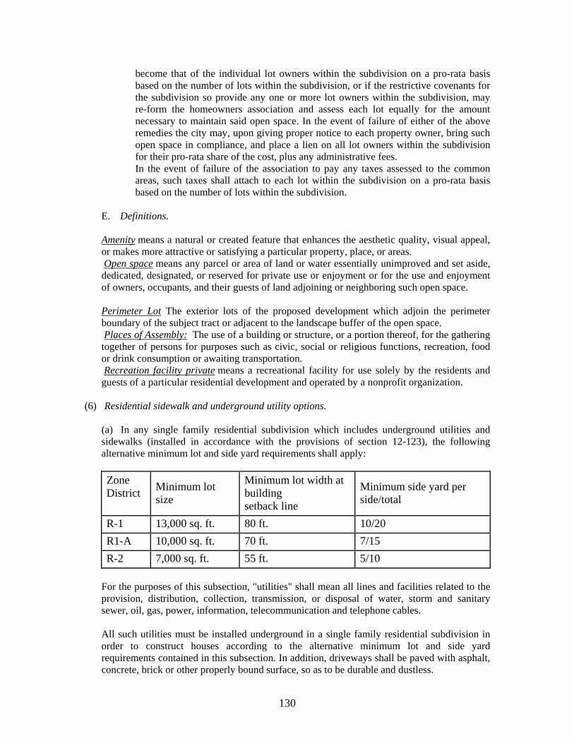
130
become that of the individual lot owners within the subdivision on a pro-rata basis based on the number of lots within the subdivision, or if the restrictive covenants for the subdivision so provide any one or more lot owners within the subdivision, may re-form the homeowners association and assess each lot equally for the amount necessary to maintain said open space. In the event of failure of either of the above remedies the city may, upon giving proper notice to each property owner, bring such open space in compliance, and place a lien on all lot owners within the subdivision for their pro-rata share of the cost, plus any administrative fees. In the event of failure of the association to pay any taxes assessed to the common areas, such taxes shall attach to each lot within the subdivision on a pro-rata basis based on the number of lots within the subdivision.
E. Definitions. Amenity means a natural or created feature that enhances the aesthetic quality, visual appeal, or makes more attractive or satisfying a particular property, place, or areas. Open space means any parcel or area of land or water essentially unimproved and set aside, dedicated, designated, or reserved for private use or enjoyment or for the use and enjoyment of owners, occupants, and their guests of land adjoining or neighboring such open space. Perimeter Lot The exterior lots of the proposed development which adjoin the perimeter boundary of the subject tract or adjacent to the landscape buffer of the open space. Places of Assembly: The use of a building or structure, or a portion thereof, for the gathering together of persons for purposes such as civic, social or religious functions, recreation, food or drink consumption or awaiting transportation. Recreation facility private means a recreational facility for use solely by the residents and guests of a particular residential development and operated by a nonprofit organization.
(6) Residential sidewalk and underground utility options.
(a) In any single family residential subdivision which includes underground utilities and sidewalks (installed in accordance with the provisions of section 12-123), the following alternative minimum lot and side yard requirements shall apply:
Zone District
Minimum lot size
Minimum lot width at building setback line
Minimum side yard per side/total
R-1 13,000 sq. ft. 80 ft. 10/20
R1-A 10,000 sq. ft. 70 ft. 7/15
R-2 7,000 sq. ft. 55 ft. 5/10
For the purposes of this subsection, "utilities" shall mean all lines and facilities related to the provision, distribution, collection, transmission, or disposal of water, storm and sanitary sewer, oil, gas, power, information, telecommunication and telephone cables. All such utilities must be installed underground in a single family residential subdivision in order to construct houses according to the alternative minimum lot and side yard requirements contained in this subsection. In addition, driveways shall be paved with asphalt, concrete, brick or other properly bound surface, so as to be durable and dustless.
131
(b) The exemptions allowed by subsection 11-612(2) shall not apply to this section with the exception of subsection (f). Overhanging roof, eaves, gutters, cornices, or other architectural features shall project not more than eighteen (18) inches from the structure. (c) Exterior walls located less than six and one-half (6.5) feet from the property line must have a water resistant gypsum wall board of a minimum 5/8" Type X (or equivalent) on the outside of the exterior wall. This wall board will serve as an underlayment for the exterior siding material. Homes that have continuous exterior soffitts must have the wall board run continuous to the roof deck (or fire blocked) and be sealed against the deck to prevent the movement of air into the attic space. These requirements apply notwithstanding any provision of the Standard Building Code to the contrary. (d) Reserved. (e) Reserved. (f) Perimeter lots that adjoin an existing street that is maintained by the city street department, the county highway department, or the state department of transportation shall have driveway access from an internal street only. Sidewalks shall be required along existing streets described above. In the event that scheduled improvements to these roadways would displace newly constructed sidewalks, upon determination by the city street superintendent, in lieu of construction along these existing roadways, the developer shall be required to pay the cash equivalent of the construction costs of these sidewalks to the city street department. (g) If a determination cannot be made concerning setback compliance of a structure under construction, the building and codes department may require sufficient evidence from the builder that foundations are in compliance with all setback requirements.
Sec. 11-613. Special area requirements for any lot without sanitary sewer. For those areas not served by a sanitary sewer system, the lot area requirements shall be determined by the planning commission based on recommendations of the health department, but in no case shall be less than the minimum area required in the district in which it is located. Sec. 11-613.1. Site plan requirements. Whenever regulations contained in this section are different from regulations contained in other city ordinances, the most restrictive regulations shall prevail. 1. Applicability.
A. The provisions of this section shall apply to all uses except single-family, two-family, three-family, and four-family dwellings on individual lots. With the exception of properties located within the CBD Central Business District, no building or structure shall be erected in any zone district until and unless a site plan meeting the requirements of this section has been submitted and approved by the Regional Planning Commission. B. Exemptions. This section shall not apply to:
(1) Building additions when:
132
• The addition is under 800 (eight hundred) square feet and the total maximum lot coverage is not exceeded or • The existing building's gross square footage is expanded by three percent (3%) or less and the total maximum lot coverage is not exceeded
(2) New signs for existing buildings when: • The new sign replaces an old sign of the same size and type, and in the same location. • Only the sign face is changed. • Any new sign in a new location for an existing building, unless it is over 50' in height.
(3) Canopies, awnings or decks added to existing buildings. (4) Temporary tents, structures or uses as regulated by section 11-608 and section 11-609. (5) Temporary signs as regulated by section 11-501, signs billboards and other outdoor advertising. (6) All residential permitted and accessory uses and structures. (7) Home occupations as regulated in Section 11-607. (8) Private airports or landing fields, with no structures. (9) All agricultural uses, buildings, activities, and their accessory uses. (10) Roadside stands offering for sale, farm products grown on the premises and other related products. (11) Non-commercial greenhouses and plant nurseries. (12) Small and large family day care homes. (13) Bed and breakfast establishments as regulated by section 11-619. (14) Publicly-owned or operated parks and playgrounds.
C. Staff level review. Site plan review and approval may be handled at the planning commission staff level and may not require regional planning commission approval under the following circumstances:
(1) Any one parcel site in a platted subdivision. (2) Any building addition where the existing building's gross square footage is expanded by less than twenty-five percent (25%) but greater than three percent (3%). (3) Any new sign over 50' in height in a new location for an existing building. For staff level site review, subsections 2 B, C, D and E shall not apply. All other subsections of this section shall apply to the staff level review process. Staff shall forward copies of plans to applicable departments and agencies. These departments and agencies shall have seven calendar days to notify planning commission staff of any site plan concerns or deficiencies that would require either plan resubmittal or formal regional planning commission approval. The developer or owner of the property whose specific activities as listed above are either exempted from this section or permitted to obtain staff level approval shall nevertheless be responsible for complying with all other sections of the ordinance from which this section derives, and/or any other provisions or permits that may apply to the specific activity. Developments that require site plan review shall show all signage information as described in subsection 3 of this section. The director of planning reserves the right to revoke any of the above exemptions of this section.
2. Procedure. A. Filing of application and plans. An application for site plan review shall be submitted together with fourteen (14) prints of the proposed site plan and a simplified 8 1/2" X 11" reduction of the proposed site plan to the planning commission staff at least twenty-two (22) days prior to consideration of the plan by the planning commission. The planning
133
commission staff shall acknowledge receipt of the application by the signing and dating of said application by any person so authorized. The planning commission staff shall forward one of said copies to the city engineer, the city street department, AT&T, the department of electricity, the city fire department, the city building department, the director of schools and where applicable, the Tennessee Department of Environment and Conservation and the Tennessee Department of Transportation. B. Informational review. The planning staff shall determine whether all information pertinent to the review has been provided and within seven (7) calendar days of receipt of the application shall notify the applicant that either:
(1) The application has been accepted for consideration or, (2) Additional information is required. If additional information is required, the applicant has until the time of the departmental review meeting to furnish the staff with a designated number of copies of the corrected site plan. If such information is not furnished before said time, the site plan may not be placed on the agenda for the planning commission meeting the following week.
C. Departmental review. The planning staff, affected agencies, and applicant and/or developer shall meet the week before the scheduled planning commission meeting to review and discuss development plans. The applicant will be notified of the time, date and location of this review. The applicant is encouraged but not required to attend this meeting. During the meeting, departmental staff may request site plan changes, additional information or clarification of items pertinent to the site plan. If changes or additional information is required, the applicant has until noon on the Monday immediately prior to the planning commission meeting to furnish the staff with a designated number of copies of the corrected site plan. If such information is not furnished before said time, the site plan may not be placed on the agenda for the planning commission meeting. D. Notice. A notice of hearing shall be sent by mail not less than seven days before the date of the scheduled planning commission meeting to the applicant and to adjacent landowners. E. Planning commission action. The regional planning commission shall approve, approve with conditions or disapprove each site plan. Action may be deferred on any site plan if the planning commission needs additional study or information prior to taking action. If approved conditionally, the conditions shall be stated; and if necessary, the commission may require the applicant to submit a revised site plan. If disapproved, the reasons for such action shall be stated; and if possible, recommendations made as to the basis on which the site plan would be approved. F. Effect of approval. Site plan approval or conditional approval shall be authorization for the applicant to proceed with the development of the construction documents required for review and approval prior to the issuance of any required permits. Prior to the issuance of a building permit, evidence must be provided to the planning commission verifying that any required site plan conditions have been met. Construction documents may include, but may not be limited to, site layout, landscape and buffer, grading, erosion control, stormwater, utility and building plans. Upon receipt of required permits, the developer may proceed under the supervision of the city street department, the city building department, the regional planning commission, and/or the city engineer with the construction of any improvements. Site plan approval does not constitute acceptance of the project for permitting. Any approved site plan that is modified during the development of the construction documents shall be submitted to the planning commission staff for review. Staff shall review the submitted plan within 7 calendar days to ascertain the degree of modification and shall notify the applicant if the revised site plan will require regional planning commission approval. Major changes to the approved site plan shall be considered the same as a new application and made in accordance with the procedures specified in this section. The
134
planning commission staff may approve minor changes to the approved site plan provided that such changes:
(1) Do not increase the density. (2) Do not change the property lines or setbacks. (3) Do not change the proposed use. (4) Do not significantly change the location or amount of land devoted to principal or auxiliary buildings, parking, pedestrian and vehicular circulation, storage, loading or landscaping and buffers. (5) Do not significantly change the development from any plans submitted or presented by the developer. Minor changes may include, but are not limited to, minor shifting of the location of building(s), parking, circulation, storage and loading areas, proposed utilities or other features of the plan. Upon site plan approval, the applicant will provide the planning commission staff with a copy of the approved site plan in a digital format as required by the staff. Approval of a site plan, conditions stipulated, and variances granted shall become void after a period of two years unless a building permit has been issued for the project. Developments for which a permit is not issued within this time limit must be resubmitted for approval as new site plans. In the event that a building permit is issued for only a portion of the area originally approved on a site plan, the remaining portion of the approved site plan shall automatically be extended for a period of two years. Site plan approval, or the extension of site plan approval, is not a guarantee that all applicable requirements have been met. Unless otherwise stated elsewhere, all developments must comply with all applicable requirements, policies or regulations that are in effect at the time a building or grading permit is obtained.
3. Content. Whenever reasonable, the site plan shall be drawn at a scale of no less than one inch equals fifty feet (1" = 50'-0"). All site plans shall be submitted on a minimum sheet size of 11"X 17" and a maximum sheet size of 30"X 42". All plans or sets of plans are to be submitted individually folded, not rolled, to a size no greater than 8 1/2" X 11". A licensed professional as required by the State shall prepare the site plan. The site plan shall include:
a. Project Name. b. Developer's name, address and phone number. c. Owner's name, address and phone number if other than the developer. Engineer/land surveyor/landscape architect's name, address and phone number. d. Location/vicinity map at a scale of 1 inch equals 2000 feet showing the relation of the proposed site to the adjoining area. e. Tax map number and parcel number. f. North arrow. g. Graphic and written scale. h. Date, including any dates of revisions. i. Closed property boundary indicating bearings and distances on all property lines. j. State site review case number (once issued). k. State current zoning of the site and zoning case number. l. State acreage of the site and the current and proposed use of the site. m. Adjacent property information including subdivision name, lot numbers, property owners, zoning, land uses, etc. n. Indicate all existing conditions, structures, pavement widths, etc. o. Existing topography at not greater than five foot intervals and list source of data. p. Location of existing and proposed bodies of water, the location of natural drains, proposed major drainage system features, and method of discharging storm water.
135
q. Location of all sinkholes within the site itself and for a distance of 200 feet outside the property. If any portion of the development drains toward an outside area show or note the route of water runoff. r. Location of existing and proposed open spaces or recreational amenities; s. Location and extent of all land subject to flooding by the overflow or ponding of storm water. t. Proposed means and direction of surface drainage. u. For any site subject to flooding, the limits of floodway areas, the regulatory flood elevation and regulatory flood protection elevation, and the minimum first floor elevation. v. Proposed grading. w. Indicate all existing and proposed easements, setbacks, landscape strips and buffers. x. Indicate all proposed site improvements, including buildings (including for all residential activities, the number of dwelling units the building is intended to accommodate), parking (including layout of facilities, number of spaces, location of driveways, entrances and walks), signage (including type and material), dumpsters and dumpster pads, loading/service and storage areas, fences and walls (including type and material), etc. y. Proposed floor area, building heights, finished floor elevations, lot coverage ratio and percent impervious surfaces. z. Indicate location of existing and proposed utilities, sewers (including size and invert elevations where pertinent), and fire hydrants within or adjacent to the site. aa. Where subsurface sewage disposal is anticipated, certification from the division of ground water protection office approving the lot for use. bb. All adjoining roadways, with names and pavement and right-of-way widths. cc. Site plan shall include a pedestrian circulation plan to include a combination of internal sidewalks, crosswalks, and/or access ramps, etc. and shall meet American with Disabilities Act regulations at the time of construction. dd. All parcels of land intended to be dedicated or reserved for public use. ee. All travel easements shall be shown and labeled on the site plan, to include pedestrian circulation within the proposed development.
(1) In approving commercial or industrial easements, the planning staff shall consider such factors as circulation (vehicular and pedestrian), access, ingress and egress, parking, as well as maintenance of said easement and other subdivision and zoning requirements of any lots(s) affected by said easement(s). The Planning Director shall have the authorization to determine whether such travel easement may be utilized within a development.
(2) The parcels involved in the easement agreement shall be served internally by a common parking lot, no parking shall be allowed in said easement.
(3) Site plan shall be submitted prior to, or concurrently with the platting of lots being served by said travel easement.
(4). All travel easements shall have direct usable access to a public roadway. ff. Indicate limits of construction. gg. City of Clarksville General Site Notes. hh. Any other information that may be necessary for the full and proper consideration of the proposed site plan.
4. Variances, modification, and waivers. Each modification, variance, or waiver of any minimum requirement of the zoning ordinance sought by a developer/applicant shall be obtained from the appropriate agency or board prior to the filing of an application for site plan review. Evidence of any variance obtained shall be submitted as part of the site plan application.
136
5. Field inspection. Prior to the issuance of a certificate of occupancy, a staff person of the building department shall conduct a final field inspection of the project. This inspection will ensure compliance with the approved site plan. Sec. 11-614. Tow-in lots.
A tow-in-lot is defined as a commercial lot to which any motorized vehicle is towed and stored for a specified storage fee, and no substantial work is performed on such vehicle. Tow-in-lots may be operated either as a principal use or as an accessory use in C-2, C-5, M-1 and M-2 districts.
Such vehicles shall not be stored on the lot for more than ninety (90) days; all unclaimed vehicles will be granted additional storage time with applicable documentation from the state, and the owner or operator of the facility shall maintain a register listing the owner of each vehicle, date of arrival and date of departure, and description (year, make, VIN). The register shall at all times be kept open for the inspection and examination by authorized persons such as police, insurance investigators, and city officials.
Dismantling or demolition of said vehicles for the salvage of parts is not permitted on the lot.
The storage and parking lot for all such vehicles shall be screened from off-site view by placement in an enclosed building or behind a wall or fence at least six (6) feet in height. Barbed wire may be added to the top of such fencing, pursuant to Sec. 10-203 of this Code. Any fence used to satisfy the requirements of this subsection shall contain slats at least one-fourth ( 1/4) inch thick, which shall be installed over no less than 2/3 of the surface area of the fence. Slats shall be made of plastic, vinyl, or metal. Natural objects such as trees or other plantings may also be used to satisfy the screening requirements, with the written approval of the building official. Fences and screening shall be maintained in good condition. Up to one hundred twenty-eight (128) square feet of fence area in a single location may remain unscreened for security purposes.
The above required screening may be varied on a case-by-case basis upon application to the board of zoning appeals. In considering variances from the screening requirements of this section, the board shall consider the following:
(1) A reduction in the required screening will not adversely affect adjacent properties and other properties in the area, taking into account existing uses and zoning of properties. (2) Proposed screening shall reasonably protect persons and property from noise, vibration, glare, and similar hazards. (3) Visibility from public rights-of-way shall be reasonably protected.
All tow-in-lots in existence upon the effective date of the ordinance from which this section derives shall have ninety (90) days from that date to be in compliance with all provisions contained herein.
Sec. 11-615. Recycling collection facilities. (a) Definition. "Recycling collection facility" means a center for the acceptance by donation, redemption, or purchase or recyclable materials from the public. Such a facility shall not use power processing equipment. (b) Small recycling collection facility. Small recycling facilities shall be permitted in all commercial (C1, C2, C3, C4, C5) and industrial (M1, M2, M3) districts only when issued a small recycling collection facility placement permit from the building and codes department. They shall be operated only in conjunction with an existing principal facility. Small recycling collection
137
facility sites shall not occupy more than one thousand (1,000) square feet of the parcel on which they are placed, and the collection containers shall not occupy more than two hundred (200) square feet. There shall be only one collection facility per parcel of land.
(1) Permit; inspection; violation. No small collection facility shall be established until a small recycling collection facility placement permit has been issued by the building and codes department. Subsequent to issuing the placement permit the building and codes department shall inspect the facility to insure compliance with this section. Any person, firm, corporation, or agent who violates any provision of this section, or fails to comply herewith, or with any of the requirements thereof, shall be guilty of a misdemeanor. (2) Operation requirements. A small recycling collection facility shall meet the following requirements to operate:
a. Small recycling collection facility shall be set back at least ten (10) feet from any street right-of-way line and shall not obstruct pedestrian or vehicular circulation. b. Side and rear yard setback requirements shall be those that are provided for the zoning district in which the facility is located. c. Facilities shall accept only glass, metals, plastic containers, papers, and/or other similar items which may be used for remanufacturing or reprocessing of similar materials. d. Containers must be covered and secured from unauthorized entry or removal of materials. e. Facility shall be maintained free of litter and any other undesirable materials on a daily basis. f. Containers shall be clearly marked to identify the type of material which may be deposited in each container. A notice shall be posted stating that no material shall be left outside the collection containers. g. The facility shall be clearly marked to identify the name and phone number of the party responsible for maintaining the facility and ensuring compliance with all established requirements. h. The hours of operation shall be clearly posted. i. Occupation of parking spaces by the facility and by an attendant shall not reduce the number of available parking spaces below the minimum number required for the primary host. j. Maximum signage for the facility shall be ten (10) square feet and used for advertising or directional purposes only. The location of any signs must be approved by the building and codes department.
(c) Large recycling collection facilities. Large recycling collection facilities shall be permitted in all industrial districts (M1, M2, M3) only when issued a large collection facility placement permit from the building and codes department. A large collection facility is not required to operate in conjunction with an existing principal facility, and it may have a permanent building. A large collection facility site shall not occupy more than twenty thousand (20,000) square feet of the panel on which it is placed, and the containers shall not occupy more than one thousand (1,000) square feet.
(1) Permit; inspection; violation. No large recycling collection facility shall be established until a large recycling collection facility placement permit has been issued by the building and codes department. Subsequent to issuing the placement permit the building and codes department shall inspect the facility to insure compliance with this section. Any person, firm, corporation, or agent who violates any provision of this section, or fails to comply herewith, or with any of the requirements thereof, shall be guilty of a misdemeanor.
138
(2) Operation requirements. A large collection facility shall meet the following requirements to operate:
a. Facility shall be screened from the public right-of-way by operating in an enclosed building or within an area enclosed by a fence at least six (6) feet in height. b. Facility shall be located at least five hundred (500) feet from property zoned for residential use. c. Setback requirements shall be those that are provided for the zoning district in which the facility is located. d. All storage of materials shall be in sturdy containers or enclosures which are covered, secured, and maintained in good condition. e. Site shall be maintained free of litter and any other undesirable materials, and will be cleaned of loose debris on a daily basis. f. An area for adequate traffic circulation and off-street, short-term parking shall be provided. g. Containers shall be clearly marked to identify the type of material that may be deposited. h. Facility shall be clearly marked to identify the name and phone number of the party responsible for maintaining the facility and ensuring compliance with all established requirements. i. The hours of operation shall be clearly posted. j. Notice shall be posted that no materials shall be left outside the collection containers or enclosures. k. Signs shall be as regulated in title 11, chapter 5.
(d) Processing facility. A processing facility is a building or enclosed space used for the collection and processing of recyclable materials. Processing means the preparation of materials for efficient shipment, or to an end user's specifications. Any facility that is larger than a large collection facility is included in this category. Processing facilities shall be located in a general industrial district (M2) and meet the requirements of that district (see section 11-317 subsection (3)(m)). Sec. 11-616. Adult-oriented establishments.
Notwithstanding any other provisions of this title, no adult-oriented establishment shall be located on any property with a zone classification other than C-5 Highway and Arterial Commercial District. Sec. 11-617. Communication stations and towers.
Pursuant to Tennessee Code Annotated Sections 13-24-301 through 13-24-303, communication stations, including towers and operating equipment, which furnish utility services to the public are allowed in any zone district and shall adhere to the following standards:
a. All towers shall be constructed in accordance with Electronic Industries Association ("EIA") Standard 222E-1991, utilizing a wind rating of eighty (80) miles per hour plus ice loading for Montgomery County, Tennessee. Each application for a building permit shall be accompanied by a certification by a professional engineer licensed in the State of Tennessee and competent in such design, attesting to the fact that all applicable standards have been met.
139
b. A plot plan in compliance with this section shall be submitted to the building and codes director prior to the issuance of a building permit. The director may require any other documentation or information deemed necessary to complete the permit application. c. All towers shall be set back from all property lines by a distance that is equal to the height of the tower. d. All applications for permits to build towers in the City of Clarksville must be accompanied with a "Determination of No Hazard" from the Federal Aviation Administration, as well as all required Federal Communications Commission permit information, and any other documentation as required herein. e. All structures regulated herein shall be subject to the height restrictions and requirements of the AP Airport Overlay District, and applications for permits must contain documentations from the manager of Outlaw Field and from the manager of the Fort Campbell Air Traffic Control Division that such structures do not constitute a hazard to their airport facilities. f. The entire site containing the tower and equipment shall be enclosed with a fence not less than six (6) feet in height. Access gates will be locked at all times when the site is not occupied. g. All tower sites shall be provided with continuous, solid screening around the outside of the required fencing, and it shall be of such plant material as will provide a year-round evergreen screening. Screening, as required herein, shall not be less than six (6) feet in height at the time of planting, and shall be permanently maintained. h. Any outside lighting shall be arranged so as to minimize glare and reflection on adjacent properties and public streets. All towers that require marking or lighting shall be done in compliance with Federal Aviation Administration regulations, but no tower shall be lighted from dusk to dawn by any form of white flashing light, unless required by the Federal Aviation Administration. i. Satellite dishes, and television antenna which are not attached to a tower that provides utility services to the public shall be exempt from the provisions of this section. With the exception of subsections b, d, e, and j of this section, private ham radio towers which are not attached to a tower that provides utility services to the public shall be exempt from the provisions of this section. j. This section shall apply to any new structure as well as any existing structure to which the height is proposed to be increased. k. Any communication device which is proposed to be attached to an existing municipal or utility district water tank shall be exempt from the setback and screening requirements of this section. Sec. 11-618. Open-air markets.
No open-air market shall be operated upon any realty or upon personal property located within the city without approval of the board of zoning appeals, and only in C-5 highway and arterial commercial district and M-1 light industrial district.
140
(a) Plans submittal and approval. The board should not approve the operation of any open-air market until a proper site plan has been submitted showing compliance with the following minimum requirements:
(1) Each open-air market shall provide 5.5 parking spaces per one thousand (1,000) square feet of gross sales area. (Sales area shall be designated on the site plan.) (2) Each open-air market shall provide bathroom facilities in accordance with the 1997 Standard Plumbing Code for mercantile occupancies. (Calculations shall be made using the gross square footage of the sales area as designated on the site plan.) (3) No temporary bathroom facilities shall be permitted. (4) No person, including but not limited to open-air market promoter, operator, owner, employee, manager, vendor, shall be allowed to camp or reside overnight with or without a recreational vehicle, tent, vehicle or other structure at an open-air market, except that the owner may allow no more than two (2) overnight security personnel who may be either the owner or agent of the owner. (5) All sales areas shall be permanently covered by a roof and completely floored by a concrete floor of minimum thickness of four (4) inches, except that sales shall be allowed from sheds, stalls, or booths which have been approved by the building and codes department and meet the minimum requirements of the standard codes. All such structures shall require building permits and inspections by the city, the same as for other construction. No sales shall take place outside the designated sales area. (6) All open-air markets shall be conducted entirely within an area, which is screened, by natural objects, plantings, fences, or other appropriate means. Screening shall be a minimum of seven (7) feet in height. (7) All signs must be permitted in accordance with the zoning ordinance of the city. (8) All temporary tents and shelters shall require placement permits and inspections. (9) All booths and stalls shall meet the minimum setbacks as set forth in the zoning ordinance, except that the board of zoning appeals can approve variances where applicable. (10) The board of zoning appeals may impose any other reasonable conditions upon the operation of open-air markets in accordance with section 11-803 of this Code.
Sec. 11-619. Bed and breakfast establishments. The following standards shall apply to bed and breakfast establishments: (1) The only required meal to be provided to guests shall be breakfast, and it shall only be served to guests taking lodging in the establishment. (2) Individual rooms which are rented shall not contain cooking facilities. (3) The owner or manager must reside on the premises or on an immediately adjacent parcel of property. (4) The bed and breakfast establishment shall not create noise, light or traffic conditions detrimental to neighboring properties. (5) No exterior alterations to the residential structure shall be made that will change its character as a residential structure.
141
(6) Off-street parking shall be provided, however no off-street parking is permitted in the front yard area. (7) Off-street parking spaces shall be one for each quest/rental room in addition to the spaces required for the dwelling. (8) Screening shall be required of off-street parking areas to minimize any detrimental impact to adjoining properties. (9) No bed and breakfast establishment shall be permitted within two hundred fifty (250) feet of another bed and breakfast establishment measured from property line to property line. Sec. 11-620. Landscape, buffering and screening requirements.*
a. Purpose and intent. The general purpose of this section is to set standards for landscaping, buffering and screening in order to lessen air pollution, to reduce noise, heat, glare and erosion, to control storm water and minimize flooding, and to enhance the aesthetic appeal and economic value of properties subject to the requirements herein. This section further establishes standards for the protection and replacement of trees to insure their continued presence and associated benefits; establishes standards for screening and landscaping parking areas to reduce their impact on adjacent properties and public thoroughfares, as well as to mitigate the environmental impacts of large areas of unbroken pavement; establishes standards for buffering between different zone districts or selected land uses to mitigate the results of differing activities; and sets standards for plant materials, maintenance of required plants, and standards for the screening of unsightly areas.
In their interpretation and application the provisions of this section shall be considered minimum requirements adopted for the promotion of public health, safety, morals, convenience, order, prosperity, and general welfare of the community. Where other ordinances or regulations which may exist or be adopted hereinafter, impose greater restrictions than those specified herein, compliance with such ordinances or regulations shall be mandatory. (b) Applicability. The provisions of this section shall apply to all uses, except single-family and two-family dwellings on individual lots. Any proposed residential development in an R-3 or R-4 zone with a site plan approved by the regional planning commission prior to the enactment of this section is exempt from the provisions of this section. If the vehicular use area required for this construction exists prior to the construction of a new building or structure, that area must meet the requirements of this section. Properties within the Central Business Improvement District (CBID) shall not be required to submit and have approved by the regional planning commission landscape and tree preservation plans prior to the issuance of a building permit, as long as the CBID Design Review Board is in existence and is performing this review and approval process.
(1) New developments: No new building, structure or development shall hereafter be constructed, or parking area created, unless landscaping is provided as required by this section. (2) Changes to existing buildings, structures and developments: The requirements of this section shall be applicable to existing buildings, structures and developments as of the effective date of the ordinance from which this section derives.
a. If an existing building's gross floor area of the ground floor is expanded by fifty (50) percent or more, as determined by the building official, then the entire building, structure or development shall comply with the requirements of this section.
142
b. If there is change in use of an existing building, structure or development, which requires rezoning of the property to allow the new use, then the entire building, structure, or development including parking area shall comply with the requirements of this section. c. If the number of existing parking spaces for an existing building, structure or development is expanded by twenty-five (25) percent to forty-nine (49) percent, then the area of expansion shall comply with the requirements of this section. d. If the number of existing parking spaces for an existing building, structure or development is expanded by fifty (50) percent or more, then the entire parking lot shall comply with the requirements of this section. e. If a new and separate building, structure or development is constructed on the same lot of record as an existing building, structure or development, only the separate and new building, structure or development must meet the requirements of this section. f. Trees and shrubs should not be planted so as to obstruct access to fire hydrants or utility transformers. Alternative designs, to include reduction of required plantings, may be considered in areas where documented public safety issues have been identified.
(3) Allowance for small lots of record. If the imposition of the buffering requirements, in conjunction with the perimeter planting requirements, would result in the elimination of an otherwise legal utilization of a lot of record upon the effective date of this subsection, then the buffer yard criteria may be modified to the extent necessary to ensure development, to include such measures as fencing, decreased planting, etc.
(c) Definitions. The following definitions shall apply to the regulation and control of landscaping within this section:
(1) Access way: A paved area intended to provide ingress and egress of vehicular traffic from a public right-of-way to an off street parking area. (2) Bond: Money or a form of monetary security issued to the City of Clarksville by an owner to insure that the required site work will be performed completely and correctly within a certain time frame. This bond shall be in the form of a cashiers check, letter of credit from a banking institution, certificate of deposit, or performance bond from an insurance company. The posting of a bond satisfactory to the city will be a condition for the issuance of a temporary certificate of occupancy. (3) Buffer zone: The required installation of landscaping between land uses. (4) Buffering: The use of landscaping (other than mere grass on flat terrain), or the use of landscaping with berms, walls, or decorative fences, that at least partially obstructs the view from the street or adjoining properties of vehicular use areas, parking lots and their parked cars, loading areas, and refuse containers. (5) Building official: Person within the building and codes department, which is determined by the City of Clarksville to have authority for enforcement of this section. (6) Caliper: A standard trunk diameter measurement for nursery grown trees taken six (6) inches above the ground for up to and including four-inch caliper size, and twelve (12) inches above the ground for larger sizes. (7) Certificate of landscape compliance: A document that the contractor or installer and the owner shall submit to the City of Clarksville before final inspection that certifies that the landscape plan has been substantially implemented in its entirety. (8) Certificate of occupancy: A document issued by the building official allowing the occupancy or use of a building and certifying that the structure or use has been inspected for compliance with all the applicable municipal codes and ordinances. A temporary certificate of occupancy may be issued by the building official allowing the occupancy or use of a building, although all required work has not been completed, if the owner posts a bond.
143
(9) Critical root zone (CRZ): A circular region measured outward from a tree trunk representing the essential area of the roots that must be maintained in order for the tree's survival. The critical root zone is one foot of radial distance for every inch of tree DBH, with a minimum of eight (8) feet. (10) DBH: Diameter-at-breast-height is the tree trunk diameter measured in inches at a height of four and one-half (4 1/2) feet above the ground. (11) Deciduous: Those plants that annually lose their foliage. (12) Designer: Person, persons, or firms responsible for the preparation of the landscape plan. (13) Detention area: Area used for temporary storage and controlled release of stored storm water. (14) Director of planning: The director, or acting director, of the Clarksville-Montgomery County Regional Planning Commission and parties designated by the director, or acting director, of the Clarksville-Montgomery County Regional Planning Commission to act on their behalf. (15) Drip line: A vertical line extending from the outermost edge of the tree canopy or shrub branch to the ground. (16) Evergreen: Those plants that retain their foliage throughout the year. (17) Evergreen screen: Plants that retain their foliage year round that are planted to provide a dense vegetative screen for purposes of visual mitigation between zoning districts. (18) Ground cover: A prostrate plant growing less than two (2) feet in height at maturity that is grown for ornamental purposes. Ground covers are used as an alternative to grasses. On slopes, ground covers control erosion while eliminating the maintenance of mowing. (19) Island: In road and parking area design, a raised planting area, usually curbed, and placed to guide traffic, separate lanes, limit paving (impervious surface), preserve existing vegetation and increase aesthetic quality. (20) Land clearing: Operations where trees and vegetation are removed and which occur prior to construction of buildings, road right-of-way excavation, utility excavation, grubbing, and any other necessary clearing operation. (21) Landscape ordinance: The sections of the zoning ordinance, which regulate landscape design, landscaping, and landscape installation and maintenance. (22) Landscape plan: The preparation of graphic and written criteria, specifications, and detailed plans to arrange and modify the effects of natural features with plantings, ground and water forms, circulation, walks and other landscaping features to comply with the provisions of this section. (23) Landscape strip: An area required by this section which is reserved for the installation and/or maintenance of plant materials. (24) Landscaping: The process or product of site development including grading, installation of plant materials, and seeding of turf or ground cover. Includes any combination of living plants, such as trees, shrubs, vines, ground covers or grass; natural features such as rock, stone, bark chips or shavings; and structural features, including but not limited to, fountains, reflecting pools, outdoor art work, screen walls, fences, benches. (25) Loading areas: An area which contains trash collection areas of dumpster type refuse containers, outdoor loading and unloading spaces, recycling bins, docks, outdoor shipping and receiving areas, outdoor bulk storage of materials or parts thereof, or outdoor repair areas of any service stations, safety equipment, inspection stations or dealers. (26) Off street parking and other vehicular use area: Any area, excluding public right-of-way, used for the purpose of driving, maneuvering, parking, storing or display of motor vehicles, boats, trailers, mobile homes and recreational vehicles, including new and used automobile lots, and other parking lot uses, excluding minimum parking requirements for single family residences or duplexes.
144
(27) Owner: Any individual, corporation, partnership or entity, which owns property that is subject to the provisions of this section and any individual, corporation, partnership or entity which succeeds to such ownership. The obligations of an owner under this section, including perpetual maintenance in accordance with an approved landscape plan, are binding on any successor owner. (28) Parking lot island: An area of ground within the boundary of any parking lot, which has curbing adjacent to all paved areas. Parking lot islands are used for traffic control and as planting areas to screen and shade parking lots to minimize the detrimental environmental impacts of large paved areas. (29) Plant: A combination of vegetation in a designed, specific application which meets the purpose of this ordinance. Vegetation may include: trees, shrubs, groundcovers, vines and grasses. For purposes of this section it does not include flowers or weeds. (30) Planting area: The area prepared for the purpose of accommodating the planting of plants. (31) Planting yard: A planting area around the perimeter of a property separating the access way and vehicular use area from adjoining property and/or public right-of-way. Its purpose is to enhance the visual appearance of the site and to provide screening of the vehicular use area and certain other activities from the public right-of-way and abutting property. (32) Public street: For the purpose of this section, any public street or dedicated roadway easement. (33) Retention area: Area used for storage of storm water without controlled release of stored water. (34) Shrub, large: An upright plant growing ten (10) feet to twenty (20) feet in height at maturity planted for ornamental or screening purposes. (35) Shrub, medium: A plant growing five (5) feet to nine (9) feet in height at maturity planted for ornamental or screening purposes. (36) Shrub, small: A plant growing to less than five (5) feet in height at maturity planted for ornamental or screening purposes. (37) Sight triangle: Area at the intersection of the road right-of-way and an access point to property where driver visibility must be maintained as required in this section. (See subsection (m) of this section for further explanations). (38) Travel lanes: That part of the roadway provided for the movement of vehicles, exclusive of shoulders and auxiliary lands. (39) Tree credit: A unit of measurement used in determining a site's landscape requirements when existing trees are preserved and a tree preservation plan is submitted for approval. (See subsection (j) of this section) (40) Tree, ornamental or understory: A small to medium tree, growing fifteen (15) feet to forty (40) feet at maturity often used for aesthetic purposes such as colorful flowers, interesting bark, or fall foliage. Understory trees must be used for planting under or near overhead utility lines. (41) Tree preservation plan: A plan to preserve existing trees on a site for the purpose of receiving tree credits. (42) Tree protection zone: The area around a tree corresponding to the drip line or ten (10) feet, whichever is greater, in all directions from the trunk. (43) Tree, shade or canopy: A large tree growing to over forty (40) feet in height at maturity, usually deciduous, planted to provide canopy cover shade. (44) Vehicular use areas: All areas subject to vehicular traffic including access ways, driveways, loading areas, service areas, bicycle lanes and parking stalls for all types of vehicles. This definition does not include covered parking structures or underground parking lots.
145
(45) Vines: A woody plant that has a spreading pattern of growth. Vines may be used on the ground, on walls and on trellises. (46) Wash out area: Area where construction machinery may have concrete, or other material that may be harmful to trees, washed out or off the equipment. This area should be away from and not drain toward any existing trees.
(d.) Submittal of landscape plan. Landscape and tree preservation plans, along with support documentation meeting all specified requirements, must be submitted to the director of planning or his designee, reviewed and approved prior to the issuance of a building permit. A building permit may be issued prior to approval of a landscape plan if the proposed development has received site plan approval by the regional planning commission, and the site plan reflects adequate provisions for compliance with the landscape ordinance, as determined by the director of planning or his designee. The director of planning or his designee first conducts a review of the plans to determine if all basic information has been included. Should the plans be determined to be incomplete, they will be returned to the applicant along with a request for any additional information. The review for completeness will be made within five (5) working days of the receipt of plans. When all basic information has been supplied, the director of planning shall have fifteen (15) days to review the plans and issue a decision approving, rejecting, or conditionally approving the plans. If the plan is not approved by the director of planning it will then be reviewed by the regional planning commission within the specified time frame at its next regularly scheduled meeting. Failure to submit a complete landscape plan will result in the denial of building permits until such plan is submitted, reviewed and approved.
All submitted landscape and tree preservation plans must meet current Tennessee State Laws regarding preparation and sealing of drawings and details.
(1) Landscape plan requirements. A separate landscape plan must be submitted; provided that, if the site plan is for a building of less than fifteen thousand (15,000) square feet of ground floor area (area obscured to the sky), and is on a lot of less than two (2) acres, then the landscape plan may be combined with the site plan if the scale of the site plan is not smaller than one inch = thirty (30) feet. The landscape plan must not be of a lesser scale than the site plan. All items on the following checklist which are applicable shall be depicted on the landscape plan or the combined site and landscape plan.
a. A plant schedule. The plant schedule must contain: 1. Quantity of each plant material; 2. Common and botanical name of plant material; 3. Size and spacing of all proposed landscape material at time of planting; 4. General plant comments;
b. Plant calculations including total linear feet of frontage and buffers; c. Sight triangle shown and labeled; d. Existing plant materials to be left in natural state (non disturbed areas only); e. Methods and details for protecting existing plants (tree protection zones must be designated and established in order to receive credit for required landscaping); f. All building setback lines, landscape strips, and buffers shown and labeled; g. Location and description of required landscape improvements, including perimeter landscaping, landscaping within parking lots, and buffer zones (the description shall include the size of the parking area and the actual percentage of the parking area used for landscaping);
146
h. Location and description of other landscape improvements, such as earth berms, walls, fences, screens, sculptures, fountains, street furniture, lights, courtyards or paved areas, construction details for landscape improvements; i. Planting and installation details to ensure conformance with all required standards; j. Location and type of irrigation system compliance; k. Location of existing and proposed buildings; l. Layout of parking and traffic patterns; m. Plan drawn to scale with north arrow and any interpretative legends; n. Location and size of all overhead and underground utilities, existing and proposed; o. Location and size of all public or private easements, existing and proposed; p. Location of all existing and proposed ground signage. (Note: Approval of the landscaping plan shall not constitute any approval as to location that may be required under the sign ordinance.); q. Connections to existing streets; and, r. Zoning designation of the subject property and the adjacent properties.
(2) Support documentation. Support documentation, if required, shall include but may not be limited to, copies of the grading, drainage and erosion control plans when required by and submitted to the city street department. Plans shall meet all requirements as specified in the city stormwater management ordinance. (3) Changes and resubmittals. A change to a previously approved landscape plan requires resubmittal and reapproval before the installation of plant materials. Such changes may occur as a result of, but are not limited to a:
a. Reduction in the quantity of required landscape materials. b. Reduction in the size of plant materials (if adding larger plant materials of the same category, resubmittal and reapproval are not necessary). c. Change in location of plant materials (no revisions are necessary if minor field adjustments, not to exceed three (3) feet, must occur). d. Change in design, layout or location of design elements such as: earth berms, buffer zones, walls, fences etc. e. Change in location of overhead or underground utilities. Changes to a previously approved landscape plan will not require resubmittal and reapproval before the installation of plant materials if such changes occur as a result of change in species due to lack of plant availability. However, the new plants must be of the same general category, i.e. shade tree, ornamental tree, evergreen tree, deciduous shrub, or evergreen shrub, and shall maintain the same general design characteristics, such as form, mature height, crown spread and intent, as the plants on the originally approved landscape plan.
(e) Exceptions and appeals. (1) Submittal and approval of alternative methods of compliance. If application of these landscape requirements to a particular lot would be unreasonable or impractical, or would damage or eliminate existing vegetation, a landscape plan may be submitted with a request for approval of an alternate and equivalent means of providing landscaping. The need for alternative means of landscaping might arise from unusual site conditions, including streams, natural rock formations or topography; or for the preservation of significant landscape features or wetlands or from an unusual lot configuration or development design; or, from the presence of utility easements. The request for approval of an alternative to the landscape requirements must specify the reason for requesting the alternative and the landscape plan must demonstrate the equivalency of the proposed alternative to the requirements. The planning director or his designee will determine if the proposed alternative is equivalent and whether it meets the intent and purpose of the ordinance. The regional planning commission
147
may consider appeals from this decision and the decision of this body shall be final. This determination may take into account the land use classification of adjacent properties; the number of plantings, species, arrangement and coverage proposed; the location of the plantings on the lot; and the level of screening, height, spread, and canopy of the plantings at maturity. (2) Each applicant for a variance shall have the burden of proving that compliance with the landscape requirements would be extraordinarily difficult because of one or more unusual characteristics of the property. Generally such characteristic may not have been created by deliberate action of the owner or the owner's representative. Each applicant for a variance must prove that an alternative and equivalent means of landscaping is not viable. In considering a variance request, cost alone is not an extraordinary difficulty and it does not justify granting a variance.
(f) Installation. All landscaping materials shown and listed on the approved plans shall be installed in a sound, workmanship like manner and according to accepted, good construction and planting procedures. Plants installed shall meet the standards for size, form and quality set out in the American Standard for Nursery Stock, latest edition. Any landscape material, which fails to meet the minimum requirements of this section at the time of installation, shall be removed and replaced with acceptable materials. All trees and shrubs shall be tagged according to species. Tags shall not be removed until after inspection. (g) Inspections for certificate of occupancy. Site inspections for the issuance of a certificate of occupancy will occur only after the contractor or installer and the owner have submitted a landscape certificate of compliance to the building official or his designee. No certificate of occupancy for any development on a site subject to the landscaping requirements of this section shall be issued until all landscaping materials are in place in substantial compliance with the approved landscape plan. However, should conditions occur beyond the reasonable control of owner that would delay the installation of the landscaping, the owner may submit an installation bond or other financial instrument acceptable to the city and in an amount set by the building official to cover the cost of incomplete work. The amount of installation bond required shall be set by a schedule adopted by the building official or his designee. A permanent certificate of occupancy will be issued by the building official or his designee when it is verified that the plantings are correct as to their location, size, number, and species; all required planting yards, parking lot plantings, and buffer zones have been installed; the installed system meets the irrigation requirements and the site does not violate the sight triangle prohibitions. (h) Maintenance. The person in charge of or in control of the property whether as owner, lessee, tenant, occupant, or otherwise shall be responsible for the continued proper maintenance of all landscaping materials and shall keep them in proper, neat and orderly appearance, free from refuse and debris at all times. All required landscaping shall be watered by one of the following methods: an underground sprinkling system or a hose attachment within two hundred feet of all landscaping. The use of plants which are naturally adapted to the climatic conditions of Clarksville, and which can survive drought in the opinion of the director of planning or his designee is recommended. Undisturbed areas of natural vegetation retained in fulfillment of the requirements of this code shall not require irrigation. All unhealthy or dead plant material shall be replaced within one year, or by the next planting period, whichever comes first; while other defective landscape material shall be replaced or repaired within three (3) months. Violation of these installation and maintenance provisions shall be grounds for the building official or his designee to refuse a building occupancy permit, require replacement of landscape material or institute legal proceedings to enforce the provisions of this section.
148
(i) Administration and enforcement.
(1) The director of planning or his designee shall be the person responsible for review and approval of landscape plans and tree preservation plans. (2) Decisions regarding landscape plans may be the subject of an administrative appeal to the Clarksville-Montgomery County Regional Planning Commission whose decision shall be final. (3) All further enforcement of an approved landscape plan or tree preservation plan and the continued maintenance thereof will be the responsibility of the building official or his designee.
(j) Credit toward landscaping for preserved trees.
(1) Credits for preserved trees are offered when a tree preservation plan is submitted and approved along with the site plan prior to commencing any grading or construction activity on a site. A tree preservation plan may be submitted as part of the landscape plan. A tree preservation plan must show that there will be no substantial disturbance in the critical root zone (CRZ). A substantial disturbance is considered compaction of soil, trenching, placing backfill in the CRZ, grading or dumping of trash, oil, paint, or other materials detrimental to plant health in close proximity of the tree(s). (2) Only those trees that are determined to be viable and savable will receive tree credits. A tree(s) that is determined to be hazardous, diseased or severely injured will not receive tree credits. Likewise, if it is determined that a large portion of the root system of a tree(s) will be disturbed or destroyed by grading, trenching etc. then no tree credits will be granted. Only those trees that exhibit a reasonable chance of survival will receive tree credits. Should the owner of the property wish to receive credit for a tree that did not initially qualify for credit, then said owner may provide documentation regarding the particular tree's health and survivability. This documentation shall include any and all corrective measures, including long-term maintenance that would be effective toward saving the tree(s). The planning director or his designee will review any such additional documentation. (3) Protective barricades or tree fence shall be placed around all trees designated in the tree preservation plan prior to the start of development activities, and shall remain in place until development activities are complete. The area within the protective barricade shall remain free of all building materials, dirt or other construction debris, vehicles and development activities. Failure to comply with this requirement will result in the denial of tree credits and the landscape plan will have to be modified to include new tree plantings. (4) Decisions regarding tree credits may be the subject of an administrative appeal to the regional planning commission whose decision shall be final. (5) The following information shall be submitted and/or indicated on the tree preservation plan:
a. Tree survey at the same scale as the site plan or landscape plan, showing location of each existing tree(s) to be preserved that is six (6) inches in diameter or larger; b. Groups of trees in close proximity (those within five (5) feet of each other) may be designated as a clump of trees, with the predominant species, estimated number and average diameter indicated. Any tree greater than twenty-four (24) inches DBH must be identified individually; c. Tree inventory including location, species, size and condition of each tree; d. Trees which are noteworthy due to size, age, historic, cultural or aesthetic value; e. Trees to be removed; f. Location and type of tree protection barrier with tree save area labeled; g. Existing and proposed grades;
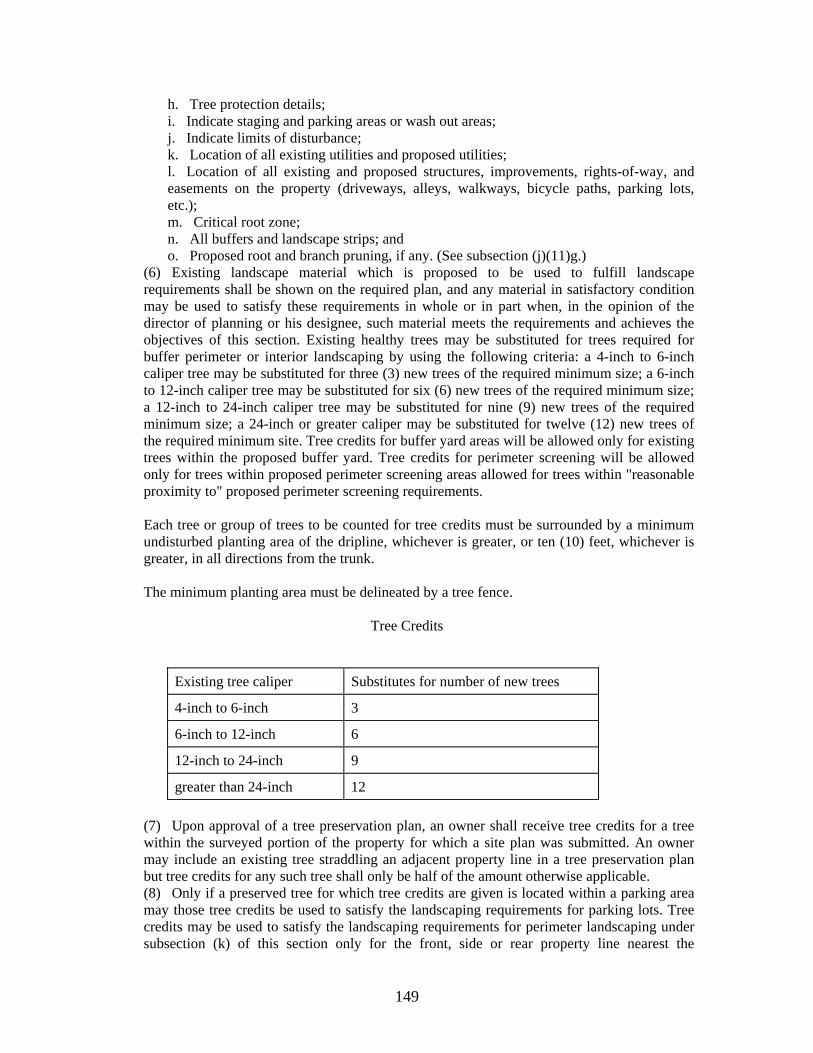
149
h. Tree protection details; i. Indicate staging and parking areas or wash out areas; j. Indicate limits of disturbance; k. Location of all existing utilities and proposed utilities; l. Location of all existing and proposed structures, improvements, rights-of-way, and easements on the property (driveways, alleys, walkways, bicycle paths, parking lots, etc.); m. Critical root zone; n. All buffers and landscape strips; and o. Proposed root and branch pruning, if any. (See subsection (j)(11)g.)
(6) Existing landscape material which is proposed to be used to fulfill landscape requirements shall be shown on the required plan, and any material in satisfactory condition may be used to satisfy these requirements in whole or in part when, in the opinion of the director of planning or his designee, such material meets the requirements and achieves the objectives of this section. Existing healthy trees may be substituted for trees required for buffer perimeter or interior landscaping by using the following criteria: a 4-inch to 6-inch caliper tree may be substituted for three (3) new trees of the required minimum size; a 6-inch to 12-inch caliper tree may be substituted for six (6) new trees of the required minimum size; a 12-inch to 24-inch caliper tree may be substituted for nine (9) new trees of the required minimum size; a 24-inch or greater caliper may be substituted for twelve (12) new trees of the required minimum site. Tree credits for buffer yard areas will be allowed only for existing trees within the proposed buffer yard. Tree credits for perimeter screening will be allowed only for trees within proposed perimeter screening areas allowed for trees within "reasonable proximity to" proposed perimeter screening requirements. Each tree or group of trees to be counted for tree credits must be surrounded by a minimum undisturbed planting area of the dripline, whichever is greater, or ten (10) feet, whichever is greater, in all directions from the trunk. The minimum planting area must be delineated by a tree fence.
Tree Credits
Existing tree caliper Substitutes for number of new trees
4-inch to 6-inch 3
6-inch to 12-inch 6
12-inch to 24-inch 9
greater than 24-inch 12
(7) Upon approval of a tree preservation plan, an owner shall receive tree credits for a tree within the surveyed portion of the property for which a site plan was submitted. An owner may include an existing tree straddling an adjacent property line in a tree preservation plan but tree credits for any such tree shall only be half of the amount otherwise applicable. (8) Only if a preserved tree for which tree credits are given is located within a parking area may those tree credits be used to satisfy the landscaping requirements for parking lots. Tree credits may be used to satisfy the landscaping requirements for perimeter landscaping under subsection (k) of this section only for the front, side or rear property line nearest the
150
preserved trees; e.g. preserved trees in a fence row on a rear property line may be used to satisfy the perimeter landscaping requirement for the rear but not the front or side property lines. (9) Should any tree designated on the tree preservation plan die or be removed at anytime after approval of the plan or issuance of a certificate of occupancy, the owner shall replace sufficient landscaping equal to the tree preservation credit within six (6) months. The owner shall notify the city in writing and submit plans to the regional planning commission for approval showing the location of the tree(s) lost and the number, size, species and location of replacement tree(s). The replacement tree(s) shall be a minimum of two (2) inches in caliper for a deciduous tree, a minimum of six (6) feet in height for an evergreen tree. (10) If it is determined that a tree proposed for credit on a development site is undesirable due to visible weakness, limited life span, susceptibility to disease, and/or overpopulation of the species, such tree shall not be eligible for credit. Such species may include, but are not limited to, Box Elder (female), Silver Maple, Bradford Pear, Hackberry, American Elm, Osage Orange (female), Cottonwood (except hybrids), Siberian Elm, Tree of Heaven, Mimosa, Gingko (female), Mulberry, and Empress trees. (11) Trees offered for credit are to be protected on or adjacent to a development site. The following procedures shall be followed to adequately protect the trees during construction.
a. A protection barrier or tree fence shall be installed at a minimum of four (4) feet in height around the tree that is identified to be protected. The tree fence shall be constructed before the issuance of any permits, and shall remain intact throughout the entire period of construction. b. The tree fence shall be constructed of a barrier material securely fastened to a wood or metal frame properly braced by two-by-four inch minimum structural members with cross braces, or another form of substantial barrier approved by the building official. c. The tree fence shall be installed to whichever is greater, either the drip line, as measured from the trunk of the protected tree [i.e., if the radius of the drip line is twenty (20) feet, the radius of the tree fence shall be installed at a minimum distance of twenty (20) feet] or ten (10) feet, whichever is greater, in all directions measured from the trunk. d. Any required excavation in or around the protection zone to accommodate underground services, footings, etc. shall be indicated on the plan, and shall be excavated by hand. In addition, related root pruning shall be accomplished via ANSI (American National Standards Institute) A-300-95 standard so as to minimize impact on the general root system. e. The storage of building materials or stockpiling shall not be permitted within the limits of or against the protection barriers. f. Trees within the protection barriers must be adequately cared for throughout the construction process (i.e., they must be watered sufficiently, particularly if the tree's root system has been disturbed by excavation.) Fill shall not be placed upon the root system in such a manner as to endanger the health or life of the affected tree. g. Proposed root and branch pruning, where necessary, shall be noted on the tree preservation plan and shall be accomplished in accordance with standard tree pruning practices, as established by ANSI (American National Standards Institute) A-300-995 standards. Tree topping shall not be permitted.
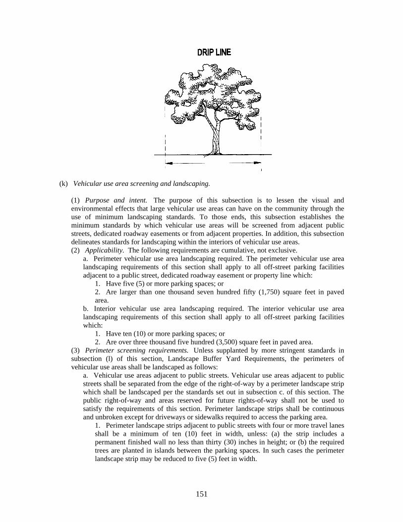
151
(k) Vehicular use area screening and landscaping.
(1) Purpose and intent. The purpose of this subsection is to lessen the visual and environmental effects that large vehicular use areas can have on the community through the use of minimum landscaping standards. To those ends, this subsection establishes the minimum standards by which vehicular use areas will be screened from adjacent public streets, dedicated roadway easements or from adjacent properties. In addition, this subsection delineates standards for landscaping within the interiors of vehicular use areas. (2) Applicability. The following requirements are cumulative, not exclusive.
a. Perimeter vehicular use area landscaping required. The perimeter vehicular use area landscaping requirements of this section shall apply to all off-street parking facilities adjacent to a public street, dedicated roadway easement or property line which:
1. Have five (5) or more parking spaces; or 2. Are larger than one thousand seven hundred fifty (1,750) square feet in paved area.
b. Interior vehicular use area landscaping required. The interior vehicular use area landscaping requirements of this section shall apply to all off-street parking facilities which:
1. Have ten (10) or more parking spaces; or 2. Are over three thousand five hundred (3,500) square feet in paved area.
(3) Perimeter screening requirements. Unless supplanted by more stringent standards in subsection (l) of this section, Landscape Buffer Yard Requirements, the perimeters of vehicular use areas shall be landscaped as follows:
a. Vehicular use areas adjacent to public streets. Vehicular use areas adjacent to public streets shall be separated from the edge of the right-of-way by a perimeter landscape strip which shall be landscaped per the standards set out in subsection c. of this section. The public right-of-way and areas reserved for future rights-of-way shall not be used to satisfy the requirements of this section. Perimeter landscape strips shall be continuous and unbroken except for driveways or sidewalks required to access the parking area.
1. Perimeter landscape strips adjacent to public streets with four or more travel lanes shall be a minimum of ten (10) feet in width, unless: (a) the strip includes a permanent finished wall no less than thirty (30) inches in height; or (b) the required trees are planted in islands between the parking spaces. In such cases the perimeter landscape strip may be reduced to five (5) feet in width.
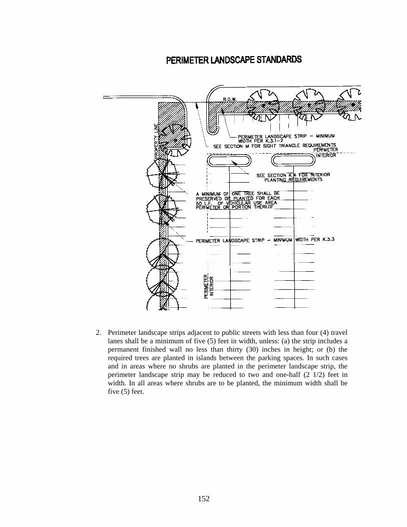
152
2. Perimeter landscape strips adjacent to public streets with less than four (4) travel
lanes shall be a minimum of five (5) feet in width, unless: (a) the strip includes a permanent finished wall no less than thirty (30) inches in height; or (b) the required trees are planted in islands between the parking spaces. In such cases and in areas where no shrubs are planted in the perimeter landscape strip, the perimeter landscape strip may be reduced to two and one-half (2 1/2) feet in width. In all areas where shrubs are to be planted, the minimum width shall be five (5) feet.
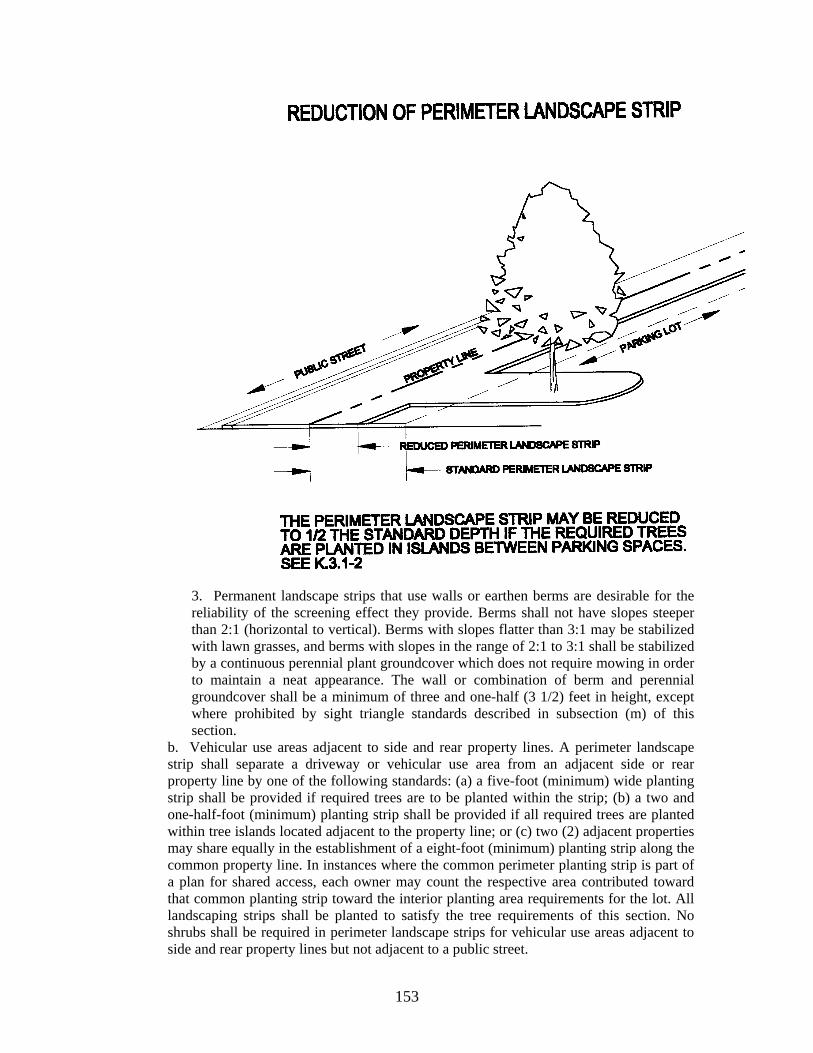
153
3. Permanent landscape strips that use walls or earthen berms are desirable for the reliability of the screening effect they provide. Berms shall not have slopes steeper than 2:1 (horizontal to vertical). Berms with slopes flatter than 3:1 may be stabilized with lawn grasses, and berms with slopes in the range of 2:1 to 3:1 shall be stabilized by a continuous perennial plant groundcover which does not require mowing in order to maintain a neat appearance. The wall or combination of berm and perennial groundcover shall be a minimum of three and one-half (3 1/2) feet in height, except where prohibited by sight triangle standards described in subsection (m) of this section.
b. Vehicular use areas adjacent to side and rear property lines. A perimeter landscape strip shall separate a driveway or vehicular use area from an adjacent side or rear property line by one of the following standards: (a) a five-foot (minimum) wide planting strip shall be provided if required trees are to be planted within the strip; (b) a two and one-half-foot (minimum) planting strip shall be provided if all required trees are planted within tree islands located adjacent to the property line; or (c) two (2) adjacent properties may share equally in the establishment of a eight-foot (minimum) planting strip along the common property line. In instances where the common perimeter planting strip is part of a plan for shared access, each owner may count the respective area contributed toward that common planting strip toward the interior planting area requirements for the lot. All landscaping strips shall be planted to satisfy the tree requirements of this section. No shrubs shall be required in perimeter landscape strips for vehicular use areas adjacent to side and rear property lines but not adjacent to a public street.
154
c. Landscape materials. A minimum of one tree shall be preserved or planted for each fifty (50) feet of vehicular use area perimeter, or portion thereof. This does not mean trees are to be planted fifty-foot on center. Trees planted to meet this requirement shall measure a minimum of two (2) inches in caliper for a deciduous tree, and six (6) feet in height for an evergreen tree. The area within the perimeter landscape strip which fronts on a street right-of way shall be planted with evergreen shrubs at a standard of ten (10) shrubs per one hundred (100) linear feet of frontage, i.e., for two hundred fifty (250) linear feet of frontage, twenty-five (25) shrubs would be required. Shrubs shall be a minimum of eighteen (18) inches high at planting. No more than forty (40) percent of any one genus (trees and shrubs) may be included in any planting. The remainder of the area within all perimeter strips not occupied by required trees or evergreen shrubs shall be covered by organic or mineral mulches, other shrubs, groundcover plants or grassed lawns. Trees, shrubs and ground covers may be massed to create a more naturalistic planting. The use of concrete, asphalt or other impervious surfaces shall be prohibited. A list of recommended and prohibited trees is available from the regional planning commission. This list will periodically be updated as needed. d. Corner visibility. Trees and other landscaping required in the perimeter strip shall be planted and maintained to assure unobstructed corner visibility pursuant to sight triangle requirements of this section. For developments where the entire road frontage is within a sight triangle, the required perimeter landscape strip trees for this frontage shall be planted in an adjacent perimeter landscape strip; or in lieu of the frontage trees, the frontage landscape strip will be significantly enhanced with shrub and ground cover planting above and beyond the required planting. e. Adjacent vehicular use areas with shared access. Vehicular use areas on adjacent properties, which are designed to share a common access from the public right-of-way and a vehicular travel way along their common property line shall be exempt from the requirement for a vehicular use area perimeter landscape strip along their common property line, upon the recording of an easement agreement which provides for the mutual right of ingress and egress for both property owners.
(4) Interior planting requirements.
a. General requirements. At least five (5) percent of the gross area of the vehicular use area shall be landscaped. But in no case shall the combined perimeter and interior landscape area requirement exceed fifteen (15) percent of the total land area. Interior planting areas are to be located within or adjacent to the parking area as tree islands, at the end of parking bays or inside eight-foot wide or greater medians (where the median area is to be included as a part of the calculations for the interior planting area) or five-foot if concrete bumper blocks are provided. Interior planting areas shall be located so as not to impede storm-water runoff and provide shade in large expanses of paving and contribute to orderly circulation of vehicular and pedestrian traffic. The required number of parking spaces may be decreased by the number of tree islands created to meet the minimum interior planting requirement of this section. For example, the required creation of three (3) separate tree islands, if within the proposed required off-street parking area(s), would allow the minimum number of parking spaces required by section 11-401 to be reduced by three (3) spaces.
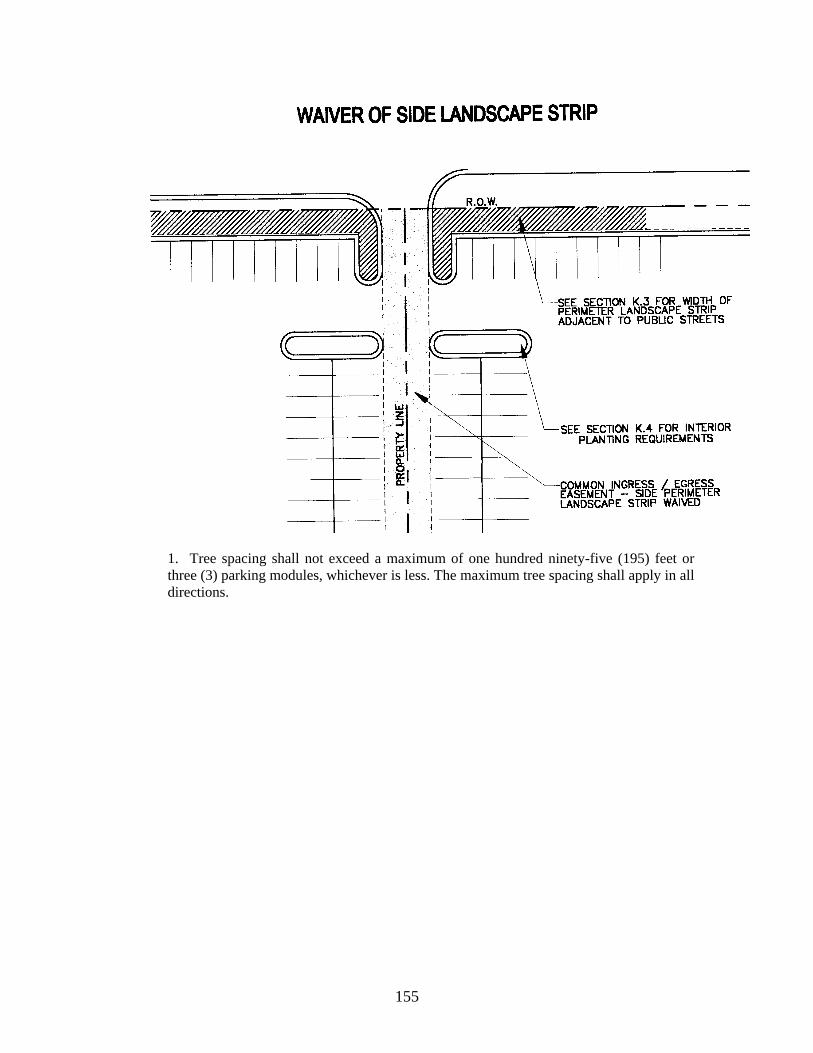
155
1. Tree spacing shall not exceed a maximum of one hundred ninety-five (195) feet or three (3) parking modules, whichever is less. The maximum tree spacing shall apply in all directions.
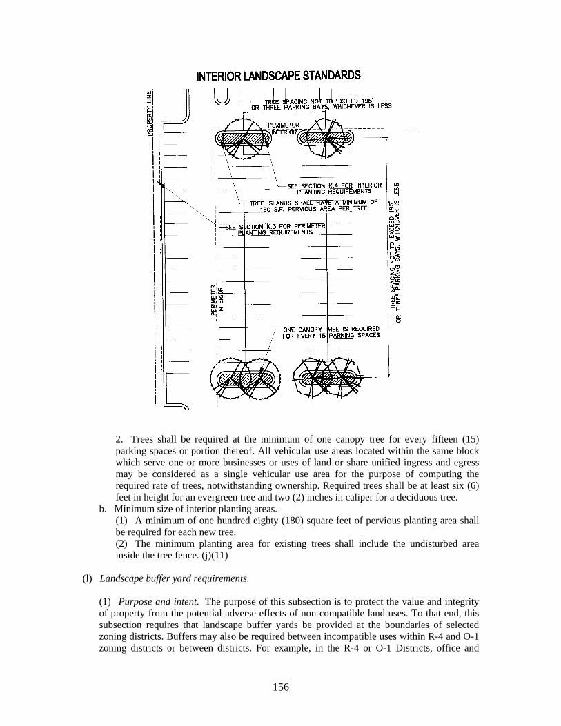
156
2. Trees shall be required at the minimum of one canopy tree for every fifteen (15) parking spaces or portion thereof. All vehicular use areas located within the same block which serve one or more businesses or uses of land or share unified ingress and egress may be considered as a single vehicular use area for the purpose of computing the required rate of trees, notwithstanding ownership. Required trees shall be at least six (6) feet in height for an evergreen tree and two (2) inches in caliper for a deciduous tree.
b. Minimum size of interior planting areas. (1) A minimum of one hundred eighty (180) square feet of pervious planting area shall be required for each new tree. (2) The minimum planting area for existing trees shall include the undisturbed area inside the tree fence. (j)(11)
(l) Landscape buffer yard requirements.
(1) Purpose and intent. The purpose of this subsection is to protect the value and integrity of property from the potential adverse effects of non-compatible land uses. To that end, this subsection requires that landscape buffer yards be provided at the boundaries of selected zoning districts. Buffers may also be required between incompatible uses within R-4 and O-1 zoning districts or between districts. For example, in the R-4 or O-1 Districts, office and
157
professional uses will be required to provide an "A buffer" when adjacent toR-4 or O-1 residential uses. The landscape buffer yard standards of this subsection are also employed by other subsections to accomplish special screening and buffering objectives. The width of the landscape buffer yard and the intensity of plantings required may vary depending upon the relative intensities of the abutting zone districts or the activity itself. In most cases, the property owner may choose among a number of buffer yard widths and plantings to satisfy the requirement. In some cases, minimum buffer widths may be set by the director of planning or his designee. Buffering requirements may be reduced or eliminated if it is determined by the planning staff, that the proposed use would have a minimal impact on the immediate surrounding area; or if it is determined that the likelihood exists of similar development occurring within a reasonable amount of time. (2) Landscape buffer yard required for double frontage lot. In cases where residential lots in zoning districts covered by this section are developed with frontage and access to a street within the subdivision and the rear of the lot is oriented toward a public right-of-way, the rear of such double frontage lots shall be screened from the public right-of-way by a landscape buffer yard according to the following standards:
Street Type Buffer Standard
Local street Standard A
Collector street Standard B
Arterial street Standard C
(3) Exemptions. No landscape buffer yard shall be required in the following situations:
a. When a zoning boundary falls along a public street or along an elevated railroad bed, navigable river, controlled access highway, or other natural topographic or man made feature which provides adequate buffer in the opinion of the director of planning.
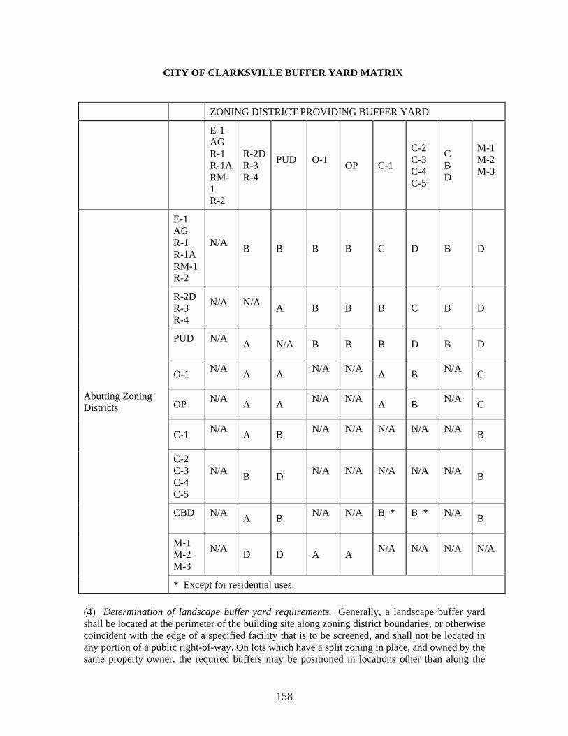
158
CITY OF CLARKSVILLE BUFFER YARD MATRIX
ZONING DISTRICT PROVIDING BUFFER YARD
E-1 AG R-1 R-1ARM-1 R-2
R-2DR-3 R-4
PUD
O-1
OP C-1
C-2 C-3 C-4 C-5
C B D
M-1 M-2 M-3
Abutting Zoning Districts
E-1 AG R-1 R-1A RM-1 R-2
N/A
B B B B C D B D
R-2D R-3 R-4
N/A
N/A
A B B B C B D
PUD
N/A
A N/A B B B D B D
O-1 N/A
A A N/A
N/A
A B N/A
C
OP N/A
A A N/A
N/A
A B N/A
C
C-1 N/A
A B N/A
N/A
N/A
N/A
N/A
B
C-2 C-3 C-4 C-5
N/A
B D N/A
N/A
N/A
N/A
N/A
B
CBD
N/A
A B N/A
N/A
B *
B *
N/A
B
M-1 M-2 M-3
N/A
D D A A N/A
N/A
N/A
N/A
* Except for residential uses.
(4) Determination of landscape buffer yard requirements. Generally, a landscape buffer yard shall be located at the perimeter of the building site along zoning district boundaries, or otherwise coincident with the edge of a specified facility that is to be screened, and shall not be located in any portion of a public right-of-way. On lots which have a split zoning in place, and owned by the same property owner, the required buffers may be positioned in locations other than along the
159
zone district boundaries, as long as the intended effect is achieved. Where the building setback line and the width of landscape buffer differs, the greater of the two will prevail and take precedence. When the gross floor area of a building legally existing on the effective date of the ordinance is expanded by fifty (50) percent or more, that perimeter portion of the property in proximity to the area of expansion shall be brought into conformance with the landscaping buffer yards standard of this code. When incremental expansions occur over time, the total of all expansions shall be used in applying the provisions of this section. If the requirements of this section have been fully complied with on an adjoining property, additional buffer areas may not be required. The following procedure shall be followed to determine the standard of landscape buffer yard required along a zoning district boundary:
a. Identify the zone district for the proposed site as well as for the abutting site(s); b. Determine the landscape buffer yard standard required on each building site boundary (or portion thereof) by referring to the buffer yard matrix. c. Select the desired width/screening option from those listed in the illustrations at the end of this section, landscape buffer yard standards. Any of the listed width or screening variations shall satisfy the requirement between abutting zone districts.
(5) Landscape buffer yard design and materials. a. Existing native plant material. The use of existing plant material is strongly encouraged in landscape buffer yards. Existing natural groundcover shall be retained where possible by avoiding scraping, grading and sodding within the landscape buffer yard. Where the planting requirements of the landscape buffer yard standards require additional trees or shrubs to be installed in an existing natural area, installation shall minimize disturbances to native species. b. Trees. Where the planting requirements of the landscape buffer yard standards indicate that additional trees shall be installed, required trees shall be a minimum of six (6) feet in height for an evergreen tree or two (2) inches in caliper for a deciduous tree, as appropriate. No more than forty (40) percent of any one genus may be included in any planting. At least one-half ( 1/2) of the required trees shall be locally adapted natural evergreen species. Trees shall be distributed throughout the yards, so that there are no horizontal gaps between trees greater than thirty (30) feet as measured parallel to the property line except in A-1 or A-2. Required canopy trees shall have an expected mature height of forty (40) feet or greater. Required understory trees shall have an expected mature height of at least fifteen (15) feet. A list of recommended and prohibited trees is available from the regional planning commission. This list will periodically be updated as needed. c. Shrubs. No more than forty (40) percent of any one genus may be included in any planting. At least one-half (1/2) of the required shrubs shall be locally adapted natural evergreen species. Evergreen shrubs planted to meet the minimum standards of this section shall be a minimum of one and one-half (1 1/2) feet in height when planted and at least one-half ( 1/2) shall be expected to reach five (5) feet or greater in height within five (5) years of planting. Shrubs planted on berms may have a lesser mature height provided that the combined height of the berm and plantings after five (5) years is at least five (5) feet. Shrubs may be planted in staggered rows or any other pattern. Pedestrian areas and other places where surveillance for the purpose of preventing crime is a design objective may be planted with the smaller of the required shrubs. Required shrubs may be replaced with approved evergreen trees at a ration of one (1) evergreen tree per four (4) shrubs. Evergreen trees shall be a minimum of six feet in height at time of planting. d. Utility and drainage easements. Required landscape buffer yards shall not be used for utility or drainage easements unless approved by the entity controlling the easement. If such an easement exists along the perimeter of the site or if there is no alternative in locating the easement, the full landscape buffer yard shall be placed inward (toward the interior of the site) from the easement.
160
e. Vehicular use area landscaping. Perimeter plantings required for vehicular use area landscaping may be allowed to be counted toward satisfying landscape buffer yard requirements when the perimeter planting area coincides with the buffer yard. f. Compatibility of landscaping materials. Supplemental plantings shall be chosen to enhance the existing vegetation within the landscape buffer yard. The species used in the supplemental plantings shall be species that occur naturally in the landscape, and shall be selected for their noninvasive properties. g. Opaque fences. When utilized to satisfy a screening requirement of this section, opaque fences shall be constructed of permanently affixed materials that comprise an integral part of the fence itself. The use of nonrigid plastic or fabric material shall not qualify as an opaque fence. Walls shall be constructed of natural stone, brick or other weatherproof materials arranged in a linear, serpentine, or other alignment; fences shall be constructed of wood or other weatherproof, durable materials generally used in the exterior construction of buildings. Fence posts shall be structurally stable based on the material used and shall have a maximum spacing of eight (8) feet on center. If wood is used, the posts shall be four (4) inches by four (4) inches minimum. Posts shall be set in or anchored to crowned concrete footers at least six (6) inches larger in each direction than the post it supports. The base of the footer shall be at least twenty-four (24) inches below finished grade. If wood is used for any member, it shall be softwood treated with water-borne preservative to the American Wood Preservers Institute standard LP-2 for above ground use or LP-22 for ground contact use, or all-heart redwood, or all-heart cedar. All cut surfaces of pressure treated lumber shall be waterproofed. If another material is used, it shall be weatherproofed. Slats, pickets or panels are to be placed on the outside of the fence unless the design is two-sided (e.g. shadow box). All hardware is to be galvanized or otherwise rustproofed. Wood horizontal members shall be installed bark-side up. Chain link fencing may not be used. There shall be a six-foot height restriction for walls or fences in front yards and side street side yards, and an eight-foot height restriction in side and rear yards. All walls or fences shall have a minimum opacity of eighty (80) percent. Walls and fences allowed to meet the requirements of this section shall not be used for the erection or display of any sign or other advertising device. Walls and fences shall be horizontally level as opposed to following the topography of the site where said topography is other than level. In this situation, the height restriction shall apply to a reasonable average height above the grade between step-downs.
(6) Other uses within landscape buffer yards. a. Trails. Sidewalks or bike trails may occur within landscape buffer yards provided that the required effect of the yard is not compromised. In no event, however, shall the following uses be permitted in landscape buffer yards: playfields, stables, swimming pools, golf courses, tennis courts, and other recreational facilities; parking areas and other vehicular use areas; dumpsters, equipment storage and other open storage; buildings or overhangs. b. Subterranean stormwater retention/detention facilities which are designed in a manner so as not to interfere with the proper installation and maintenance of the yard are allowed. c. Buffer yards shall be continuous and unbroken except for driveways or sidewalks required to access parking areas or streets. Driveway/sidewalk penetrations shall cross the buffer yard as close to perpendicular as possible and shall not exceed twenty-five (25) percent of the entire buffer yard, with no single penetration to exceed thirty-five (35) feet.
(7) Landscape buffer yard standards. a. Application of landscape buffer yard standards. The specifications contained in the illustrations set out at the end of this section, shall be used to select the desired landscape buffer yard option for the building site. These yard requirements are stated in terms of minimum yard width and the density of required plant material per linear foot of yard. To
161
determine the total number of plants required, the length of each side of property requiring a landscape buffer yard shall be divided by one hundred (100) and multiplied by the number of plants shown in the illustration. b. Allowable design variations. The landscape buffer yard is normally calculated as parallel to the property line. However, design variations, especially when used to incorporate native vegetation into the yard area, shall be considered. The edges of the landscape buffer yard may meander provided that:
1. The total area of the yard is equal to or greater than the total area of the required landscape buffer yard; and 2. The yard measures no less than the minimum width permitted by the applicable landscape buffer yard standard at all points along the perimeter of the property line requiring a landscape buffer yard.
c. Fractional requirements. When the requirements of this section result in a fractional number of plantings, any fraction less than one-half (1/2) may be dropped and any fraction of one-half (1/2) or more shall be counted as one planting. d. Planned unit development districts. Notwithstanding any other provision of this section to the contrary, the landscaping buffer yard requirements for a PUD originally under previous zoning shall be provided as required by this code or as required in the originally approved PUD, whichever is greater. e. Yard exceeds twenty (20) percent of lot area. In circumstances where the ground area required for the landscape buffer yard exceeds twenty (20) percent of the total lot area, the width and the number of trees and shrubs within the yard may be reduced up to fifty (50) percent provided that a solid wall or closed wooden fence at least six (6) feet in height is provided along the length of the reduced landscape buffer yard. f. Grading and use of berms. Proposals for the use of berms within a landscape buffer yard shall demonstrate superior enhancement of the buffer function compared to retention of the existing grades. Grading shall not endanger or remove existing trees which occur within a landscape buffer yard, unless the proposal clearly demonstrates an enhanced buffer. The use of earthen berms within a landscape buffer yard is encouraged when disturbance to existing vegetation can be minimized. Where berms are incorporated into the yard, the required plantings may have a lesser mature height, provided that the combined height of the berm and plantings will equal the required mature heights of plantings as set forth in this section. g. Waiver of landscape buffer yard. Landscape buffer yard requirements may be waived by a demonstration of unusual site grade conditions which would clearly negate the effects of the required yard. The applicant shall furnish sections or profiles (drawn to scale) through the property line along the yard which is proposed for waiver. These drawings shall demonstrate the existing and proposed grades on both sides of the property line, as well as the principal structures on both properties. The sections or profiles shall show the line of sight for a pedestrian (taken at four and one-half (4 1/2) feet above grade) from principal entrances and from the highest point on the site to be buffered. Such profiles or sections shall clearly demonstrate that the effect of the change in grade would negate the effect of a mature landscape buffer yard thirty (30) feet in height.
(m) Landscape restrictions--sight triangle standards.
(1) A sight triangle is that area located at the intersection of two public streets or a public street and private driveway through which an unobstructed view of approaching traffic is necessary for motorists. Except as permitted in this subsection, no landscaping or vegetation, or fence, structure, or object shall be included in a sight triangle, nor shall any such landscaping or object be planted, erected or maintained within a sight triangle. A sight triangle shall be defined by the table and illustration below:
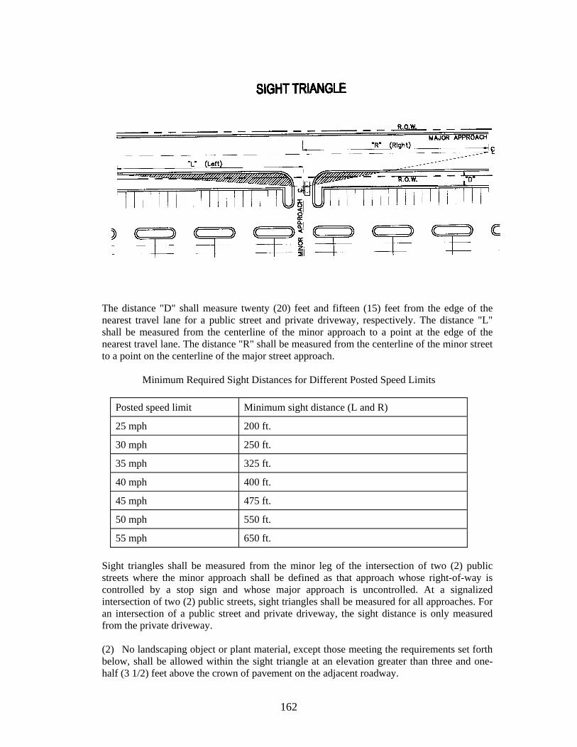
162
The distance "D" shall measure twenty (20) feet and fifteen (15) feet from the edge of the nearest travel lane for a public street and private driveway, respectively. The distance "L" shall be measured from the centerline of the minor approach to a point at the edge of the nearest travel lane. The distance "R" shall be measured from the centerline of the minor street to a point on the centerline of the major street approach.
Minimum Required Sight Distances for Different Posted Speed Limits
Posted speed limit Minimum sight distance (L and R)
25 mph 200 ft.
30 mph 250 ft.
35 mph 325 ft.
40 mph 400 ft.
45 mph 475 ft.
50 mph 550 ft.
55 mph 650 ft.
Sight triangles shall be measured from the minor leg of the intersection of two (2) public streets where the minor approach shall be defined as that approach whose right-of-way is controlled by a stop sign and whose major approach is uncontrolled. At a signalized intersection of two (2) public streets, sight triangles shall be measured for all approaches. For an intersection of a public street and private driveway, the sight distance is only measured from the private driveway.
(2) No landscaping object or plant material, except those meeting the requirements set forth below, shall be allowed within the sight triangle at an elevation greater than three and one-half (3 1/2) feet above the crown of pavement on the adjacent roadway.
163
For developments where the entire road frontage is within a sight triangle, the required perimeter landscape strip trees for this frontage will be planted in an adjacent perimeter landscape strip; or in lieu of the frontage trees, the frontage landscape strip will be significantly enhanced with shrub and ground cover planting above and beyond the required planting. (3) Notwithstanding the table and illustration provided in this section, the director of planning or his designee with concurrence from the director of streets or his designee may recommend variances of this section to the regional planning commission, which shall have the authority to grant variances upon application by the owner. Any variance for landscaping shall take into account roadway conditions as they relate to traffic control devices, alignments, geometrics, or other unique circumstances that are supported by generally accepted engineering practices or principles, or actual on site studies. (4) No landscape plan shall be approved if the landscaping proposed for the intersection of a public street and a vehicular use area would create an unsafe obstruction in the opinion of the director of planning or his designee. No landscaping or vegetation, or fence, structure, or object, shall be planted, erected, or maintained by an owner at the intersection of a public street and a vehicular use area if it creates a safety hazard by obstructing the view of a motorist.
(n) Special screening requirements. Screening of unsightly areas shall be accomplished as follows:
(1) Dumpsters and other trash receptacles for all structures other than single-family or two-family residences shall be screened from public streets or properties which are zoned or policed for residential use. Receptacles shall be placed on a concrete pad and shall be enclosed by an opaque fence or wall at least six (6) feet in height. An enclosure shall have an opaque gate unless the service opening is oriented away from public streets or adjacent residential properties. The enclosure shall be built of wood, masonry or other permanent materials and evergreen plants may be used in part to meet the requirement of opacity. (2) Mechanical equipment, terminals, satellite dishes, etc. located at grade shall be screened from all abutting public streets and residential properties by opaque fences or evergreen screens with eight (80) percent opacity at maturity in five (5) years to equal or exceed the height of equipment. Screening installed around utility equipment, including pad-mounted switchgear, transformers or junction boxes shall be installed so as not to interfere with the operation or accessibility to the equipment. (3) The exterior service areas of commercial or industrial buildings, including loading docks and outdoor storage areas, if oriented toward a public street or residential uses, shall be screened twelve (12) foot deep with evergreen trees planted in two (2) rows, offset six (6) foot on center, six (6) foot high at planting; or as approved by the director of planning or his designee. (4) Other areas, natural or manmade, may be considered unsightly and also require screening from public roads and properties zoned or policed for residential uses. These areas might include, but are not limited to, detention basins.
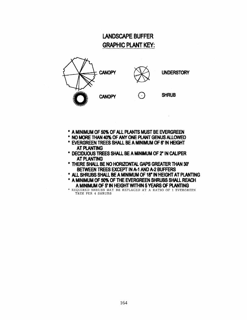
164

165
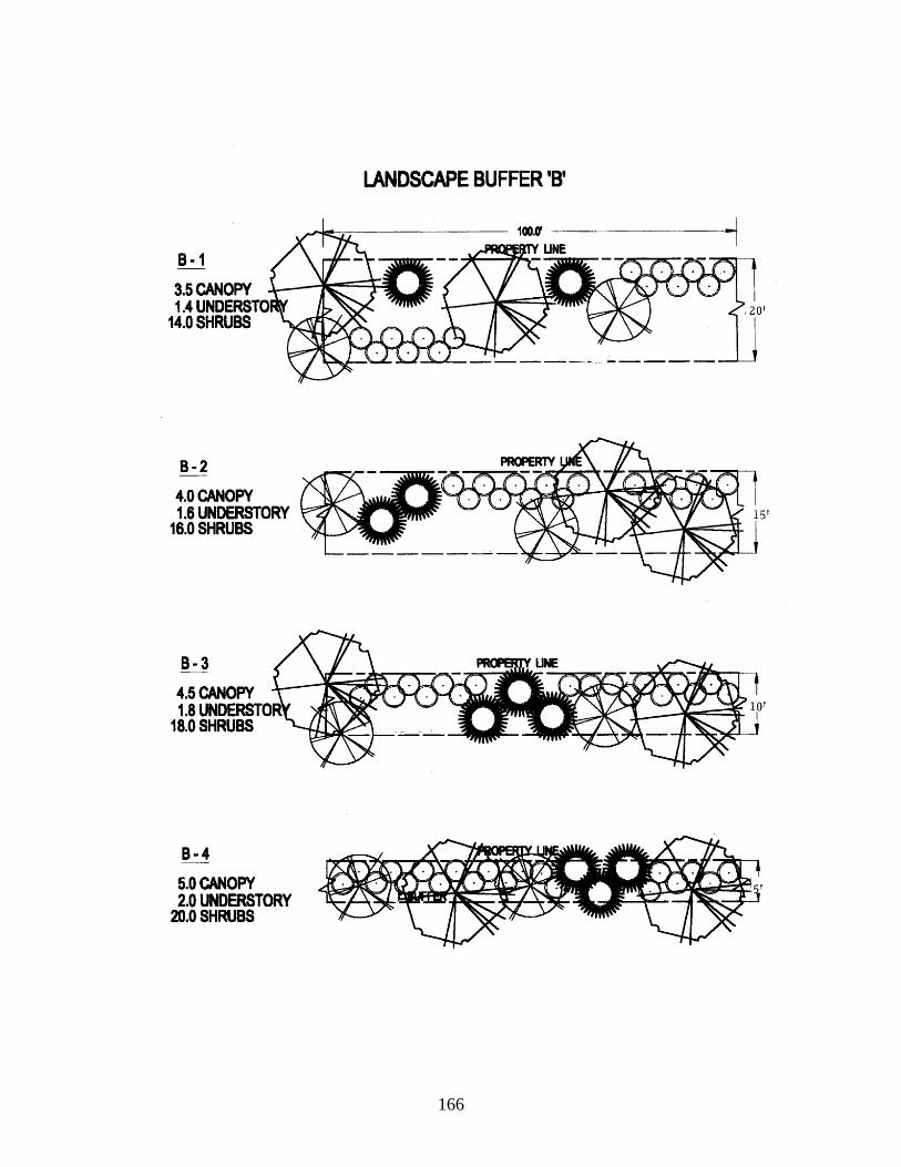
166
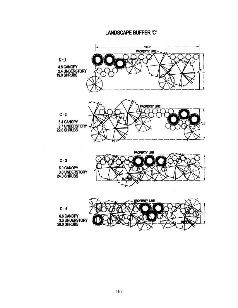
167
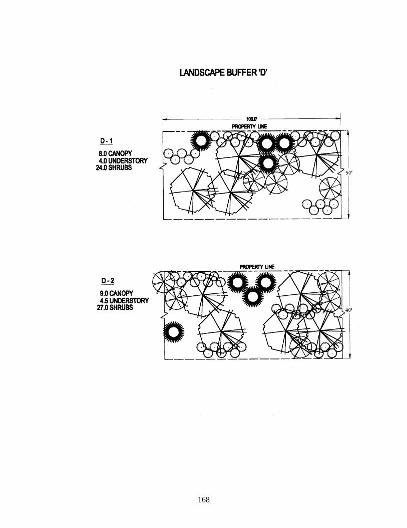
168
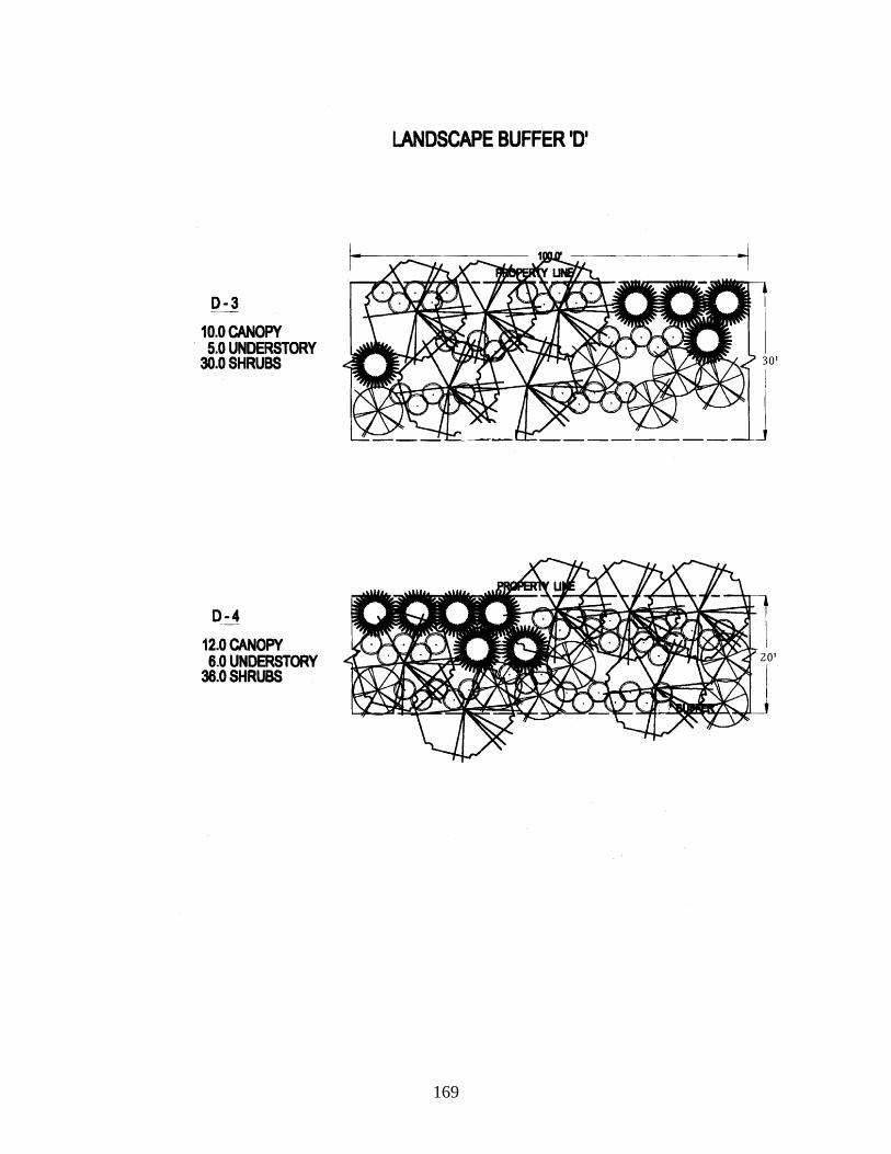
169
170
Chapter 7
NONCONFORMING BUILDINGS, STRUCTURES, AND USES
Sec. 11-701. Existing nonconforming uses, etc. A nonconforming building, structure, use of land, or a combination thereof lawfully existing at the time of the adoption of the provisions of chapters 2 through 8 of this title may be continued and maintained, except as otherwise provided in this chapter; provided, however, that nothing herein shall be construed to authorize the continuation of any illegal or nonconforming use which was illegal prior to the adoption of the provisions of chapters 2 through 8 of this title. Sec. 11-702. Alteration or enlargement of buildings and structures. A nonconforming building or structure shall not be added to or enlarged in any manner unless the building or structure, including additions and enlargements, is made to conform to all of the regulations of the district in which it is located. However, if a building or structure is conforming as to use, but nonconforming as to yards or height or off-street parking space, the building or structure may be enlarged or added to, provided that the enlargement or addition complies with the off-street parking requirements of the district in which the building or structure is located. Sec. 11-703. Outdoor advertising signs and structures. (a) All banners shall comply with the provisions of section 11-502(18) beginning November 15, 1993. All streamers/pennants shall comply with the provisions of Section 11-502(19) beginning November 15, 1993. All lights shall comply with the provisions of section 11-502(20) beginning November 15, 1993. Temporary signs are prohibited, except as provided in section 11-502(7) beginning November 15, 1993. (b) Any outdoor sign or outdoor advertising structure or billboard which, after the adoption of the provisions of chapters 2 through 8 of this title, becomes nonconforming for any reason, shall be removed or changed to conform to the regulations of the district within which it is located, either upon final depreciation of the value of the sign based upon a schedule approved by the Internal Revenue Service, or within a period of two (2) years from the date the sign becomes nonconforming, or upon expiration of the lease of the sign, whichever period is greater. However, this provision does not exempt any sign from compliance with all applicable state and federal laws, including provisions for removal contained therein. Sec. 11-704. Building vacancy. A nonconforming building, structure, or portion thereof which is or hereafter becomes unused or for which the use is suspended for a continuous period of one year shall not thereafter be occupied except by a use which conforms to the use regulations of the district in which it is located.
171
Sec. 11-705. Change in use. The use of a nonconforming building or structure may be changed to a use of the same or a more restrictive classification or to a conforming use, but such use shall not thereafter be changed to a less restrictive classification. Sec. 11-706. Nonconforming uses of land. (1) Any nonconforming use of a structure or lot which legally existed prior to the effective date of the provisions of chapters 2 through 8 of this title or any use of a structure or lot which has been rendered nonconforming by the provisions hereof, may continue to be utilized in the same fashion as existed prior to the adoption of these regulations, subject, however, to the other stated requirements under this chapter and, provided:
(a) The nonconforming use may not be extended or expanded. (b) If the nonconforming use or any portion thereof is discontinued for a period of six (6) months, or changed, any future use of the land shall be in conformity with the provisions of the district in which it is located.
(2) The following regulations shall apply to any automobile wrecking, junk, or salvage yard, building material storage yard, contractor's yard, sawmill, or any similar temporary use of land when located as a nonconforming use in any residential district. Any such use is hereby declared to be a public nuisance in any residential district established by chapters 2 through 8 of this title and shall be abated, removed, or changed to a conforming use within a period of two (2) years after the effective date of the provisions of chapters 2 through 8 of this title. (3) Any nonconforming automobile wrecking, junk, or salvage yard in any nonresidential district shall be after the adoption of the provisions of chapters 2 through 8 of this title, abated, removed or changed to a conforming use within two (2) years. Sec. 11-707. Damage. A building which, by reason of the passage of the provisions of chapters 2 through 8 of this title, has becoming nonconforming, which has been damaged by fire, explosion, act of God, or the public enemy to the extent of more than fifty (50) percent of its value at the time of damage, shall not be restored except as provided for herein below, unless the restored building is in conformity with the regulations of the district in which it is located. However, if an unusual hardship results from the damage, such as the denial of the occupant thereof of his main source of livelihood. The structure may be restored upon approval by the zoning board of appeals. When damaged by less than fifty (50) percent of its value, a nonconforming building may be repaired or reconstructed, and used as before the time of damage, provided the repairs or reconstructions are completed within one year of the date of the damage.
172
Sec. 11-708. Mobile homes. (1) Individual mobile homes within the corporate limits are prohibited except as permitted in the RM-1 zone district and within approved mobile home parks as regulated in section 11-604. (2) Where nonconforming status applies to the premises, removal or destruction of the mobile home shall eliminate the nonconforming status of the land, and an individual mobile home shall not be reestablished on the premises affected.
173
Chapter 8
ADMINISTRATION AND ENFORCEMENT Sec. 11-801. Organization. (1) Administration. The building official shall administer chapters 2 through 8 of this title and in addition shall:
(a) Issue all building permits and make and maintain records thereof; (b) Issue all certificates of occupancy and make and maintain records thereof; (c) Issue and renew, where applicable, all temporary use permits and make and maintain records thereof; and (d) Maintain and keep current zoning maps and records of amendments thereto.
(2) Board of zoning appeals. A board of zoning appeals is hereby established in accordance with title 13, chapter 7, Tennessee Code Annotated. The board of appeals shall consist of five (5) members. The members shall be appointed by the mayor and confirmed by a majority vote of the city council. The term of membership shall be five (5) years, except that the initial individual appointments to the board shall be terms of one, two (2), three (3), four (4), and five (5) years, respectively. Vacancies shall be filed for any unexpired term by appointment by the mayor and confirmation by the city council. The board of zoning appeals, City of Clarksville, Tennessee, for the purpose of this chapter, shall be referred to as the board. The board shall:
(a) Establish such rules of procedures as are necessary to the performance of its functions hereunder. (b) Function as the board of zoning appeals as defined by title 13, chapter 7, Tennessee Code Annotated, and shall have the following powers:
(i) To hear and decide appeals where it is alleged there is an error in any order, requirement, decision, or determination made by an administrative official in carrying out any provision of chapters 2 through 8 of this title. (ii) To hear and decide in accordance with the provisions of chapters 2 through 8 of this title, requests for interpretation of the zoning district map. (iii) Where there are practical difficulties or unnecessary hardships in carrying out the strict letter of chapters 2 through 8 of this title, to authorize such variance from the terms hereof as will not be contrary to the public interest. (iv) To review and decide all applications for uses permitted on review in accordance with the applicable chapters and sections of chapters 2 through 8 of this title. (v) To compel the attendance of witnesses at hearings and to administer oaths. (vi) To call on any city department for assistance in its duties. (vii) To authorize the reconstruction of a building, the use of which is nonconforming, which has been partially destroyed by explosion, fire, act of God, or the public enemy. (viii) Reduction in the parking and loading requirements of chapters 2 through 8 of this title whenever the character or use of a building or premises is such as to make unnecessary the full provisions of parking and loading facilities, or where such regulations would impose an unreasonable hardship such as extreme financial difficulty, structural difficulty, or similar condition upon the use of the property.
(3) Meetings. Meetings of the board shall be held at the call of the chairman and at such other times as the board may determine. All meetings shall be open to the public. The board shall keep
174
minutes of its proceedings, showing the vote of each member upon each question, or if absent, or if failing to vote, indicating such fact; shall take all evidence necessary to justify or explain its actions, all of which shall be immediately filed in the office of the board and shall be a public record. (4) Public hearing. Upon receipt of application for a variance, use permitted on review, an interpretation of the zoning district map, or an interpretation of any provision of chapters 2 through 8 of this title, the board shall hold a public hearing. Notification of the hearing shall appear in the newspaper of general circulation in Clarksville at least ten (10) days before the date set for the hearing. Notice also shall be mailed to the owner or his agent and to property owners directly affected at least five (5) days prior to the date set for the hearing. Upon the hearing, any person or party may appear and be heard in person, by agent, or attorney. (5) Board of adjustment and appeals.
(a) Appointment: There is hereby established a board to be called the board of adjustment and appeals, which shall consist of five (5) members. The board shall be composed of one architect, one general contractor or engineer, and three (3) members at large from the building industry. The board shall be appointed by the mayor and ratified by the city council. (b) Term of office: Of the members first appointed, two (2) shall be appointed for a term of one year, two (2) for a term of two (2) years, one for a term of three (3) years, and thereafter they shall be appointed for terms of four (4) years. Vacancies shall be filled for an unexpired term in the manner in which original appointments are required to be made. Continued absence of any member from regular meetings of the board shall, at the discretion of the mayor, render any such member liable to immediate removal from office. (c) Quorum: Three (3) members of the board shall constitute a quorum. In varying the application of any provisions of this code or in modifying an order of the building official, affirmative votes of the majority present, but not less than three (3) affirmative votes, shall be required. A board member shall not act in a case in which he has a personal interest. (d) Records: The building official or his designated agent shall act as secretary of the board of adjustment and appeals and shall make a detailed record of all its proceedings, which shall set forth the reasons for its decisions, the vote of each member participating therein, the absence of a member, and any failure of a member to vote. (e) Procedure: The board shall establish rules and regulations for its own procedure not inconsistent with the provisions of the Official Code of the City of Clarksville. The board shall meet at regular intervals, to be determined by the chairman, or in any event, the board shall meet within ten (10) days after notice of appeal has been received. (f) Appeals:
(i) Time limit: Whenever the building official rejects or refuses to approve the mode or manner of construction proposed to be followed, or materials to be used in the erection or alteration of a building or structure, or when it is claimed that the provisions of this code do not apply, or that an equally good or more desirable form of construction can be employed in any specific case, or when it is claimed that the true intent and meaning of the Standard Building Code or the Standard Housing Code or the Official Code of the City of Clarksville, or any of the regulations thereunder, have been misconstrued or wrongly interpreted, the owner of such building or structure, or his duly authorized agent, may appeal from the decision of the building official to the board of adjustment and appeals. Notice of appeal shall be in writing and filed with the building official within ninety (90) days after the decision is rendered by the building official. In case of a building or structure which, in the opinion of the building official, is unsafe or dangerous, the building official may, in his order, limit the time for the appeal to a shorter period. Appeals hereunder shall be on forms provided by the building official.
175
(ii) Decision of the board of adjustment and appeals: Every decision of the board of adjustment and appeals shall be final, subject, however, to such remedy as any aggrieved party might have at law or in equity. It shall be in writing and shall indicate the vote upon the decision. Every decision shall be promptly filed in the office of the building official, and shall be open to public inspection. A certified copy shall be sent by mail or otherwise to the appellant and a copy shall be kept publicly posted in the office of the building official for two (2) weeks after filing. The board of adjustment and appeals shall, in every case, reach a decision without unreasonable or unnecessary delay. If a decision of the board of adjustment and appeals reverses or modifies a refusal, order, or disallowance of the building official, or varies the application of any provision of city codes, the building official shall immediately take action in accordance with the decision.
(g) Applicability of board: The hereinabove established board of adjustment and appeals shall serve and be one and the same for decisions relative to the Standard Building Code, Standard Housing Code, and Official Code of the City of Clarksville. (h) Violations and penalties: Any person, firm, corporation, or agent who violates a provision of this section or fails to comply therewith, or with any of the requirements thereof, or who erects, constructs, alters, demolishes or moves any structure, or has erected, constructed, altered, repaired, moved, or demolished a building or structure in violation of a detailed statement or drawing submitted and approved thereunder, shall be guilty of a misdemeanor. Each such person shall be deemed guilty of a separate offense for each day or portion thereof during which any violation of any of the provisions of this Code is committed or continued, and upon conviction of any such violation such person shall be punished within the limits and as provided by state laws.
Sec. 11-802. Variances. The purpose of the variance is to modify the strict application of the requirements of chapters 2 through 8 of this title in the case of exceptionally irregular, narrow, shallow, or steep lots, or other exceptional physical conditions, whereby the strict application would result in practical difficulty or unnecessary hardship which would deprive an owner of the reasonable use of his land. (1) Application. After written denial of a building permit from the building inspector, a property owner may make application for a variance using forms supplied by the building department. (2) Standards for granting variances. In granting a variance, the board shall ascertain that the following criteria are met:
(a) That the granting of the permit will not be contrary to the public interest; (b) That the literal enforcement of chapters 2 through 8 of this title will result in unnecessary hardship; (c) That by granting the permit, contrary to the provisions of chapters 2 through 8 of this title, the spirit will be observed; and (d) That by granting the permit, substantial justice will be done. (e) In addition to the above established criteria, the board may grant variances from any required building setbacks on a lot containing an existing structure if the applicant demonstrates that the following criteria have been met:
(i) A variance was not obtained prior to construction due to excusable neglect or the building was constructed in violation of applicable setbacks due to excusable neglect; and (ii) No irreparable harm will be caused by the granting of the variance.
176
(3) Reserved. (4) Expiration dates. The board may establish expiration dates as a condition or as a part of the variances. Sec. 11-803. Procedure for uses permitted on review. (a) The board of zoning appeals is authorized to hear and decide upon uses permitted on review by this section, to decide such questions as are involved in determining whether uses permitted on review should be granted, and to grant uses permitted on review with such conditions and safeguards as are appropriate under this section; or to deny uses permitted on review when not in harmony with the purpose and intent of this section. (b) A use permitted on review shall not be granted by the board of zoning appeals unless and until:
(1) An application shall be filed with the director of the building and codes department or his/her designee for review. Such application shall show the location and intended use of the site, the names of the property owners and any other material pertinent to the request which the board or the director of the building and codes department may require. (2) A public hearing shall be held as provided for in this chapter. (3) In the exercise of its approval, the board may impose such conditions upon the proposed uses of buildings or land as it may deem necessary, based upon information presented at the hearing, to prevent or minimize any adverse effects of the proposed use upon, and to insure the compatibility of such uses with, other property in the vicinity. (4) The board may establish expiration dates for any use; establish hours of operation; require greater setbacks; require adequate screening and buffering; and impose other reasonable conditions as necessitated by the general criteria listed below in order to protect the public health, safety, and welfare on any use permitted on review as a condition of approval.
(c) General criteria. General requirements are hereby established which shall apply to all applications for uses permitted on review. A use permitted on review shall not be granted by the board of zoning appeals unless and until the following determinations have been made:
(1) The proposed use is compatible with, and will not adversely affect, adjacent properties and other properties in the area. (2) Adequate public facilities, such as highways, streets, parking spaces, drainage structures, fire protection, and water and sewer services, are available to accommodate the proposed use. (3) The proposed use will not adversely affect the safety of vehicular and pedestrian circulation in the area. (4) The proposed use shall provide off-street parking and loading facilities as required by the parking requirements of this section. (5) The proposed use shall reasonably protect persons and property from erosion, flooding, fire, noise, vibration, glare, odor, or similar hazards, except in such zone district where such are allowed. (6) The proposed use is so designed, located, and proposed to be operated that the health, safety, and welfare of persons in the neighborhood will be protected.
177
(7) The request is within the provisions of uses permitted on review as set forth in this section. (8) The proposed use conforms to all applicable provisions of this section for the district in which it is to be located.
Sec. 11-804. Amendments. The regulations and zone district boundaries set forth in chapters 2 through 8 of this title may be amended, supplemented, revised, or repealed from time to time as conditions warrant, as hereinafter set forth. (1) Application. A proposed change of zoning district boundaries or of the regulations may be initiated by the city council, the planning commission, or by petition of one or more owners or authorized agents of the owner or owners of property within the area proposed to be changed. Amendments introduced shall be initiated by the filing of an application with the Clarksville-Montgomery County Regional Planning Commission. The application shall contain:
(a) The name and address of the owner and/or owners of the subject property, and the written certification of the authorized agent. (b) A written legal description of the subject property including the Montgomery County tax plat number and acreage. (c) A description of the proposed zone change, modification, or repeal together with written justifications for the request zone change. (d) The names and addresses of the adjacent property owners including those property owners across streets, roads, highways, and/or railways, and waterways which border the applicant's property. (e) Two (2) copies of a map depicting the property requested for rezoning. These maps shall be at a scale of no less than one inch equals one hundred (100) feet and no larger than one inch equals thirty (30) feet and show the following information:
(i) Title, north arrow, graphic scale, date, civil district, and the acreage of the property to be rezoned. (ii) Dimensions in feet of property to be rezoned. (iii) All roads and easements within or adjoining property to be rezoned. (iv) Location, size, type, and current use of any building on the property requested for rezoning. (v) Location of the adjoining property owners in relation to the property to be rezoned.
(2) Public hearing. Upon receipt of the approved application, the Clarksville-Montgomery County Regional Planning Commission shall schedule a hearing, having first given fifteen (15) days' notice thereof by one publication in a newspaper of general circulation. (3) Action on petition. Any proposed amendment, supplement, modification, or change shall first be submitted to the Clarksville-Montgomery County Regional Planning Commission for its recommendation. The planning commission's report shall be transmitted to the city council within thirty (30) days after receipt, unless the city council or the petitioner grants an extension of such period; otherwise, the supplement, amendment, or change shall be considered to have been recommended by the planning commission. If the city council takes no final action upon the proposed amendment, supplement, or change within ninety (90) days following the public hearing provided for in this section, the failure to act shall be deemed to be a denial.
178
Sec. 11-805. Fees. Fees required for filing appeals, fees for applications for amendments to Chapters 2 through 8 of this title, and fees for review of site plans are established as follows: Appeals or uses permitted on review - $200.00 Amendments to zone district map or text: To AG/Single-Family Residential Zone District - $364.65 To Any Other Zoning Classification (including Multi-family, office, commercial, PUD, industrial, etc.) - $607.75 Site Plans: Residential - $303.75 + $12.15 per unit Non-Residential - $303.75 + $0.024 per sq. ft. Staff Level - $243.00 Abandonments $243.00 The above fees for amendments to zone district map and text and for site plan reviews shall automatically increase by 5% on July 1 of each year, beginning July 1, 2007 through July 1, 2011. Under no conditions shall the fee, or any part thereof, be refunded for failure of the proposed amendment, appeal, or change to be enacted into law. Sec. 11-806. Enforcement. The provisions of chapters 2 through 8 of this title shall be administered by the building inspector of the city. This official shall have the right to enter upon any premises at any reasonable time for the purpose of making inspections of buildings or premises necessary to carry out his duties in the enforcement of chapters 2 through 8 of this title. Sec. 11-807. Building permit. (1) Building permit required. An application for a building permit shall be obtained from the building department. It shall be unlawful to commence the excavation or construction of any building, including accessory buildings, or to commence the moving or alteration of any building, including accessory buildings, until the building inspector has issued a building permit for the work. (2) Issuance of building permit. In applying to the building inspector for a building permit, the applicant shall submit a dimensional sketch or scale plan showing the shape, size, height, and locational arrangement of all buildings to be erected, altered, or moved and any buildings in place on the lot or parcel. The applicant shall also submit a statement that the existing and intended use of all such buildings and supply such other information as may be required by the building inspector for determining whether the provisions of chapters 2 through 8 of this title are being observed. If the proposed excavation or construction, as set forth in the application, is in conformity with the provisions of chapters 2 through 8 of this title and other ordinances of the City of Clarksville currently in force, the building inspector shall issue a building permit for the
179
excavation or construction. If a building permit is refused, the building inspector shall state the refusal in writing.
(a) The issuance of a permit shall in no case be construed as waiving any provision of chapters 2 through 8 of this title. (b) Every permit issued shall become invalid unless the work authorized by such permit is commenced within six (6) months after its issuance.
Sec. 11-808. Certificate of occupancy. No land or building shall be occupied and no change in occupancy of land, a building, or part of a building shall be made until the building inspector has issued a certificate of occupancy stating that the land, building, or part thereof, and the proposed use thereof, are found to be in conformity with the provisions of chapters 2 through 8 of this title and other applicable ordinances of the City of Clarksville related to the use of land and/or occupancy of buildings. Within five (5) days after notification that a building or premises or part thereof is ready for occupancy or use, it shall be the duty of the building inspector to make a final inspection thereof and to issue a certificate of occupancy of the land, building, or part thereof and the proposed use thereof are found to conform with chapters 2 through 8 of this title and other ordinances and codes of the City of Clarksville in force; or, if the certificate is refused, to state the grounds for the refusal in writing. Sec. 11-809. Violations. It shall be unlawful to erect, construct, reconstruct, alter, maintain, or use any building or structure, or to use any land in violation of any regulation in chapters 2 through 8 of this title. In addition to pecuniary penalties, compliance therewith may also be enforced by injunctive process at the suit of the city or the owner or owners of real estate within the district affected by the regulations of chapters 2 through 8 of this title. Sec. 11-810. Interpretation. In their interpretation and application, the provisions of chapters 2 through 8 of this title shall be considered minimum requirements adopted for the promotion of public health, safety, morals, convenience, order, prosperity, and general welfare of the community. Where other ordinances or regulations which may exist or be adopted hereafter impose greater restrictions than those specified herein, compliance with those ordinances or regulations shall be mandatory. Sec. 11-811. Amendments affecting same parcel of land. No action shall be initiated for a zoning amendment affecting the same parcel of land more often than once every twelve (12) months; provided, however, by resolution approved by a 3/4 majority of members present of the city council, that the action may be initiated at any time.
180
Chapter 9
MADISON STREET CORRIDOR DESIGN REVIEW BOARD* *Cross references: Madison Street Corridor Urban Design Overlay and Design Standards and Guidelines, App. I (under separate cover – cannot incorporate here due to drawings) Sec. 11-901. Creation and adoption of Madison Street Corridor Urban Design Overlay and Design Standards and Guidelines. The Madison Street Corridor Urban Design Overlay and Design Standards and Guidelines as prepared by Gresham Smith and Partners are hereby created and adopted. Sec. 11-902. Madison Street Corridor design review board. There is hereby created a Madison Street Corridor design review board which shall be responsible for reviewing and approving all projects within the overlay district that require demolition, building and sign permits, and that make modifications to the exterior appearance of buildings, landscaping and parking, in order to insure compliance with the above referenced design standards and guidelines. The board shall consist of five (5) members recommended by the mayor of the city and ratified by the city council. The board shall consist of two (2) design professionals, one owner of a business located within the overlay district, one member of the city council, and one attorney. The terms of the board members shall be three (3) years after the initial terms established below. No member may serve more then two (2) consecutive three-year terms. Vacancies on the board shall be filled by the city council, based on the recommendation of the mayor. Any member may be removed for cause by a majority vote of the city council. The initial terms of the initial board shall be as follows: Initial one-year term: A design professional. Initial two-year term: A member of the city council and a design professional. Initial three-year term: An attorney and a business owner. Sec. 11-903. Authorization to charge fees. The Clarksville-Montgomery County Regional Planning is authorized to charge fees as they deem appropriate for the administration of plans review required by this chapter.