civic center station area plan rafael civic center... · prepared by: 332 pine street, floor 4 san...
TRANSCRIPT

Prepared by:
332 Pine Street, Floor 4
San Francisco, CA 94104
August 2012
Final Report
San RafaelCivic Center Station Area Plan

This project is funded in part through the Metropolitan Transportation Commission’s Station Area Planning Program. The preparation of this report has been financed in part by grants from the U.S. Department of Transportation. The contents of this report do not necessarily reflect the official views or policy of the U.S. Department of Transportation.
Prepared By:
332 Pine Street 4th Floor
San Francisco, CA 94104
- AND –
414 Jackson Street Suite 404
San Francisco, CA 94111
ADVISORY COMMITTEE MEMBERS:
Emily Dean Michael Fryer (Co-chair) Elissa Giambastiani Nicholas Kapas Greg Knell Marcus Lee Casey Mazzoni Richard McGrath Brigitte Moran Andrew Patterson Jeff Schoppert (Co-chair) Roger Smith Jean Starkweather Tammy Taylor
Gayle Theard Craig Thomas Yates
Ex-officio members: Damon Connolly, City Council Barbara Heller, City Council Bob Huntsberry, Design Review Board Stanton Klose, Golden Gate Bus Passenger Advisory Committee Preston McCoy, Bicycle and Pedestrian Advisory Committee Larry Paul, Planning Commission Judy Schriebman, Las Gallinas Valley Sanitary District
�
AUGUST 2012
View online at: http://www.cityofsanrafael.org/stationareaplans

TABLE OF CONTENTS
CHAPTER 1.� Introduction ..................................................................................................................... 1�1.1� SMART ........................................................................................................................................ 1�
1.1.1� SMART System ............................................................................................................ 1�1.1.2� Civic Center Station ...................................................................................................... 2�
1.2� Purpose of the Station Area Plan ................................................................................................ 2�1.3� The Civic Center Area ................................................................................................................. 5�
1.3.1� Circulation and Station Access ..................................................................................... 5�1.3.2� Land Uses .................................................................................................................... 6�1.3.3� Population and Jobs ..................................................................................................... 8�
1.4� Relationship to Other Plans ......................................................................................................... 8�1.4.1� San Rafael General Plan 2020 ..................................................................................... 9�1.4.2� Vision North San Rafael ............................................................................................... 9�1.4.3� North San Rafael Vision Promenade Conceptual Plan ................................................ 9�1.4.4� Marin County Civic Center Master Design Guidelines ............................................... 10�1.4.5� Marin Center Master Plan ........................................................................................... 10�1.4.6� City of San Rafael Bicycle and Pedestrian Master Plan ............................................ 12�1.4.7� Summary .................................................................................................................... 12�
1.5� Plan Development Process ....................................................................................................... 13�1.5.1� Public Involvement ..................................................................................................... 13�
CHAPTER 2.� Vision for the Station Area ........................................................................................... 14�
CHAPTER 3.� Station Access and Connectivity ................................................................................ 16�3.1� Complete Streets ....................................................................................................................... 16�
3.1.1� Complete Street Prototype ......................................................................................... 16�3.1.2� Complete Streets Applications to the Civic Center Station Area................................ 16�
3.2� The Promenade ......................................................................................................................... 19�3.2.1� Near Term Recommendations ................................................................................... 19�3.2.2� Long-Term Recommendations ................................................................................... 24�
3.3� Other Pedestrian Improvements ................................................................................................ 24�3.3.1� Complete Sidewalk Network ....................................................................................... 26�3.3.2� Neighborhood Connectivity ........................................................................................ 26�
3.4� Bicycle Improvements ................................................................................................................ 29�3.4.1� Implementation of Planned Improvements ................................................................. 29�3.4.2� Connectivity with Regional Facilities .......................................................................... 31�3.4.3� Bicycle Parking ........................................................................................................... 32�
3.5� Transit Access ........................................................................................................................... 34�3.5.1� Marin Transit/Golden Gate Transit ............................................................................. 34�3.5.2� New Shuttle Service ................................................................................................... 36�3.5.3� Station Bus Facilities .................................................................................................. 38�
3.6� Vehicular Access and Circulation .............................................................................................. 38�3.6.1� Station Access ............................................................................................................ 38�3.6.2� Improvements to Accommodate Development .......................................................... 40�
3.7� Summary of Recommended Changes ...................................................................................... 41�

CHAPTER 4.� Parking ........................................................................................................................... 45�4.1� Existing Parking Conditions ....................................................................................................... 45�4.2� Parking Requirements for new Land Uses ................................................................................ 45�4.3� Parking Issues ........................................................................................................................... 47�
4.3.1� How Much SMART Parking is Needed ...................................................................... 47�4.3.2� Potential Additional Parking for SMART Patrons ....................................................... 47�4.3.3� Coordination Among Jurisdictions .............................................................................. 49�4.3.4� Parking Requirements for New Development ............................................................ 49�4.3.5� Bike Parking for Station and in New Development .................................................... 51�4.3.6� Residential Permit Parking ......................................................................................... 51�
4.4� Recommendations ..................................................................................................................... 52�
CHAPTER 5.� Land Use and Urban Design ........................................................................................ 53�5.1� Transit- Oriented Development ................................................................................................. 53�5.2� A Balanced Approach ................................................................................................................ 53�5.3� Affordable Housing .................................................................................................................... 54�5.4� Traffic Capacity .......................................................................................................................... 54�5.5� Regulatory Considerations ........................................................................................................ 54�5.6� Land Use Concepts ................................................................................................................... 57�5.7� East of US 101 Area .................................................................................................................. 59�
5.7.1� Existing Conditions ..................................................................................................... 59�5.7.2� General Plan and Zoning ............................................................................................ 60�5.7.3� Opportunities .............................................................................................................. 60�5.7.4� Recommendation ....................................................................................................... 60�
5.8� Redwood Highway Area ............................................................................................................ 61�5.8.1� Existing Conditions ..................................................................................................... 61�5.8.2� General Plan and Zoning ............................................................................................ 62�5.8.3� Opportunities .............................................................................................................. 62�5.8.4� Recommendation ....................................................................................................... 63�
5.9� Northgate Area .......................................................................................................................... 64�5.9.1� Existing Conditions ..................................................................................................... 64�5.9.2� General Plan and Zoning ............................................................................................ 65�5.9.3� Opportunities .............................................................................................................. 65�5.9.4� Recommendation ....................................................................................................... 65�
5.10� Natural Environment .................................................................................................................. 65�5.10.1� Natural Environment Actions ...................................................................................... 66�
5.11� Design Guidelines ...................................................................................................................... 66�5.11.1� General Transit-oriented Design Guidelines .............................................................. 66�5.11.2� Specific Building Design Guidelines ........................................................................... 67�5.11.3� Public Environment Design ........................................................................................ 70�
5.12� Summary of Recommendations ................................................................................................ 72�
CHAPTER 6.� Implementation .............................................................................................................. 77�6.1� Key Implementation Considerations .......................................................................................... 77�
6.1.1� Take Advantage of Previous Extensive Planning Efforts ........................................... 77�6.1.2� Station Access and Neighborhood Connectivity for Bicycles and Pedestrians .......... 77�6.1.3� Ensure that Station Parking Does Not Overwhelm Neighborhoods ........................... 78�6.1.4� Limited New Development Near Station Should Preserve Character of Area ........... 78�
6.2� Implementation Actions ............................................................................................................. 78�

LIST OF FIGURES
Figure 1 – Civic Center Area ......................................................................................................................... 3�
Figure 2 – Civic Center Station ..................................................................................................................... 4�
Figure 3 – Existing Land Use ........................................................................................................................ 7�
Figure 4 – North San Rafael Promenade Plan ........................................................................................... 11�
Figure 5 – Promenade – North Section ...................................................................................................... 21�
Figure 6 – Promenade – Civic Center Station Section ............................................................................... 23�
Figure 7 – Potential Long-Term Promenade Improvements ....................................................................... 25�
Figure 8 – Areawide Pedestrian Improvements .......................................................................................... 27�
Figure 9 – Bicycle Classifications ............................................................................................................... 30�
Figure 10 – Proposed Bicycle Connections ................................................................................................ 33�
Figure 11 – Existing Transit Service ........................................................................................................... 35�
Figure 12 – Proposed SMART Shuttle Routes ........................................................................................... 37�
Figure 13 – Station Vehicular Access ......................................................................................................... 39�
Figure 14 – Potential Additional Parking Supply ......................................................................................... 48�
Figure 15 – Potential New Parking Site ...................................................................................................... 50�
Figure 16 – Zoning Map .............................................................................................................................. 56�
Figure 17 – Planning Areas......................................................................................................................... 58�
Figure 18A – No Change Alternative .......................................................................................................... 74�
Figure 18B – Four-Story Alternative ........................................................................................................... 75�

LIST OF TABLES
Table 1 Demographic Information for the Civic Center Priority Development Area ..................................... 8�
Table 2 Current San Rafael Parking Requirements (Selected Uses) ......................................................... 46�
Table 3 General Plan 2020 Assumed Land Use Capacity ......................................................................... 54�
Table 4 Allowable Densities per San Rafael Zoning Code ......................................................................... 55�
Table 5 Implementation Plan ...................................................................................................................... 79�
JOINT PROJECT TEAM MEMBERS:
City of San Rafael: Katie Korzun, Rebecca Woodbury, Paul Jensen, Stephanie Lovette, Nader Mansourian, Kevin McGowan, Vince Guarino, Linda Jackson*
Golden Gate: Maurice Palumbo, Ron Downing
County of Marin: David Speer
Marin Transit: Amy Van Doren, David Rzepinski
SMART: John Nemeth, Alan Zahradnik, Linda Meckel
TAM: Dianne Steinhauser, John Eells
ABAG: Jackie Reinhart * Former
The Joint Project Team (JPT) consists of staff from multiple agencies that have come together to facilitate a discussion of facts related to the issues surrounding the future SMART station at the Civic Center. The recommendations in this report are from the Advisory Committee and JPT agency review is not yet complete.
San Rafael Civic Center Station Area Plan August 2012
Final Plan
1
CHAPTER 1. INTRODUCTION
The San Rafael Civic Center Station Area Plan is the culmination of nearly two years of work to identify a community vision for the area around the future Civic Center SMART station in North San Rafael. The Plan builds on previous planning efforts, and sets out a conceptual framework for development and circulation improvements in the area. No environmental review has been done as part of this conceptual planning effort. Future, detailed plans will be needed to further develop and implement the concepts in the plan and conduct environmental analysis. The Plan’s ultimate goal is supporting ridership on the Sonoma Marin Area Rail Transit (SMART) system, as well as encouraging travel within the Study Area by foot, bicycle, and transit. This chapter elaborates on the purpose of this Station Area Plan, describes the Civic Center area, summarizes the process by which the Plan was developed, and explains how this Plan relates to other adopted plans in the Study Area.
1.1 SMART
This section includes a description of proposed rail service through the area, as well as a detailed description of the planned station at the Civic Center.
1.1.1 SMART System
The SMART District is proposing implementation of passenger rail service along a 70-mile rail corridor extending from Cloverdale in Sonoma County to a station located near the Golden Gate Bridge Highway and Transit District Larkspur ferry terminal. SMART would utilize an existing rail corridor, commonly known as the Northwestern Pacific Railroad (NWP). The NWP corridor generally parallels US 101 through Sonoma and Marin Counties.
The first phase of the SMART project will connect the Downtown San Rafael station to the North Santa Rosa Station, at Jennings Avenue, and will include the Civic Center station. The latest details regarding SMART’s operating and service plans are published in Sonoma-Marin Area Rail Transit District, Passenger Rail & Pathway Project Description (Project Description; SMART, May 2010). At this time, the hours have not been set, but are generally anticipated to be between 6 AM and 8 PM weekdays during the morning and evening peak periods, with one midday service. Four trains are expected to run on weekends. SMART will plan and operate the train and construct an adjacent multi-use path. Public improvements, such as sidewalks, in the surrounding area are under City or County jurisdiction. Major components of the proposed system include:
� Operating two-way “single-track” passenger rail service, with strategically placed sidings (double-tracked segments).�
� Rehabilitation of existing tracks and at-grade crossings (there are approximately 73 public at-grade crossings and numerous private crossings)�
� Construction of 14 rail stations (9 in Sonoma and 5 in Marin)�
� Provision of park and ride lots at some station locations, including the Civic Center station�
� Operation of shuttle service at selected stations, including the Civic Center station�

San Rafael Civic Center Station Area Plan August 2012
Final Plan
2
� Provision of a Multi-use Pathway (MUP) for bicycles and pedestrians generally located within or adjacent to the rail corridor and connecting the rail stations, including 54 miles of a separate multi-use pathway and 16 miles of Class II pathway (striped bike lanes)�
� Use of heavy diesel multiple unit (DMU) trains�
SMART plans to operate two to three car DMU train sets depending on passenger demand.
1.1.2 Civic Center Station
The proposed Civic Center SMART station is located underneath US 101, just north of the Marin County Civic Center and fairgrounds along Civic Center Drive. SMART’s currently-proposed weekday service includes 15 southbound and 15 northbound trains (30 total stops per weekday), while weekend service includes 4 southbound and 4 northbound trains (8 total stops per weekday). During peak commute periods, SMART will operate two trains per hour in each direction.
The project’s EIR reported 2025 ridership forecasts for the Civic Center SMART station. These forecasts predict nearly 400 total daily boardings at the station, with approximately 100 boardings occurring during the morning peak hour. The peak parking demand for the Civic Center SMART station was predicted to be 60 parking stalls. Updated 2011 SMART ridership forecasts, estimate 468 boardings at Civic Center in 2015 for SMART’s current initial segment from Santa Rosa to San Rafael.
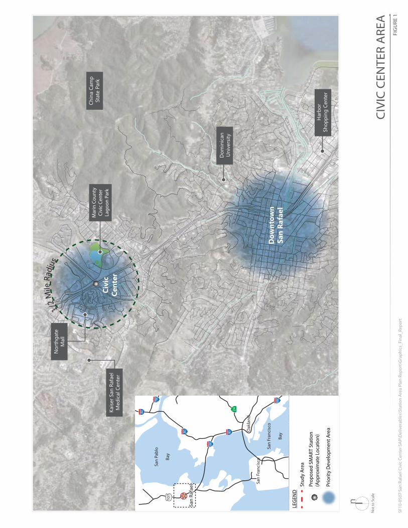
Figure 1 identifies the Study Area location, and Figure 2 illustrates a conceptual layout of the planned Civic Center station, as provided by SMART. The station will be located under an existing US 101 overpass, with connections to Civic Center Drive, to the east. The platform area is currently planned for the north side of the tracks. The MUP will generally travel along the north side of the tracks, interfacingwith the rail platform; however, a trail connection will be provided on the south side of the rail to accommodate connections from the Civic Center Drive to Merrydale Road, south of the rails.
1.2 PURPOSE OF THE STATION AREA PLAN
The SMART project is the culmination of an extensive multi-jurisdictional effort to implement passenger/commuter rail service in the North Bay. This particular planning effort at the Civic Center Station Area was largely funded by a grant from the Metropolitan Transportation Commission (MTC), the Bay Area’s regional transportation planning, coordinating, and funding agency. An Advisory Committee appointed by the City Council to represent all aspects of the Station Area community developed the recommendations in this Plan representing community desires. It focuses on key pedestrian and bicycle connections and critical transit connections. Additionally, the Plan identifies transit-oriented land use opportunities to leverage rail ridership.
This conceptual plan sets a vision for the area around the future SMART station. It will be used to inform future planning decisions and obtain grant funding for these projects. More detailed planning efforts will be necessary to further refine the ideas in this plan.
1/2
Mile
Rad
ius
Dow
ntow
nSa
n Ra
fael
Civi
cCe
nter
Chin
a Ca
mp
Stat
e Pa
rk
Nor
thga
teM
all
Kais
er S
an R
afae
lM
edic
al C
ente
r
Dom
inic
anU
nive
rsity
Mar
in C
ount
yCi
vic
Cent
erLa
goon
Par
k
Har
bor
Shop
ping
Cen
ter
San
Fran
cisc
o
Oak
land
San
Fran
cisc
o
Bay
San
Pabl
o
Bay
24
101
880
780
580
8080
80
San
Rafa
elSa
n Ra
fael
NN
ot to
Sca
le
LEG
END
Prio
rity
Dev
elop
men
t Are
a
Stud
y A
rea
Prop
osed
SM
ART
Sta
tion
(App
roxi
mat
e Lo
catio
n)
Prio
rity
D
Stud
y A
r
Prop
osed
(App
roxi
CIV
IC C
ENTE
R A
REA
FIG
URE
1
Not
to S
cale
SF10
-050
7 Sa
n Ra
fael
Civ
ic C
ente
r SA
P\D
eliv
erab
les\
Stat
ion
Are
a Pl
an R
epor
t\G
raph
ics_
Fina
l_Re
port
n

SMA
RT
CO
MM
UTE
R R
AIL
PR
OJE
Thes
e co
ncep
tual
dra
win
gs a
re in
tend
edfo
r cos
t est
imat
ion
and
valu
e en
gine
erin
gpu
rpos
es. T
hey
are
not i
nten
ded
for
bidd
ing
or c
onst
ruct
ion.
323
Gea
ry S
treet
, #60
2S
an F
ranc
isco
, CA
941
0241
5.86
1.79
00
225
Mill
er A
venu
eM
ill V
alle
y, C
A 9
4941
415.
383.
7900
R O
Y S
T O
N H
A N
A M
O T
O
A L
L E
Y
&
A B
E Y
�
�
�
�
6’12’12’ 6’
6’12’12’ 6’ CIV
IC C
ENTE
R ST
ATIO
NFI
GU
RE 2
Not
to S
cale
SF10
-050
7 Sa
n Ra
fael
Civ
ic C
ente
r SA
P\D
eliv
erab
les\
Stat
ion
Are
a Pl
an R
epor
t\G
raph
ics_
Fina
l_Re
port
n
MU
LTI-
USE
PAT
HW
AYPL
ATFO
RM
PED
ESTR
IAN
CO
NN
ECTO
R
PED
ESTR
IAN
RAI
LCR
OSS
ING
Civic Center Drive
McI
nnis
Par
kway

San Rafael Civic Center Station Area Plan August 2012
Final Plan
5
1.3 THE CIVIC CENTER AREA
This section describes the circulation, land use, and demographic context of the Study Area.
1.3.1 Circulation and Station Access
The Study Area was developed in a suburban pattern, with the resulting orientation toward automobile travel and lack of pedestrian connectivity. There are many relatively wide roadways in the area, several of which lack complete sidewalks. Those that do provide bicycle and pedestrian facilities tend to offer minimal accommodations. One exception to this is the North San Rafael Promenade, a dedicated bicycle
and pedestrian pathway planned between the Terra Linda Recreational Center, the Northgate Mall, the Civic Center Station, and the Marin County Civic Center. A portion of this facility adjacent to the Northgate Mall has already been constructed, providing a higher quality of bicycle and pedestrian facility than typically characterizes this area, and future portions of this facility will offer connections to major destinations throughout the area, including the planned SMART Station.
Overall, connectivity in the area is difficult due to 1) the major infrastructure that divides the Study Area, especially the US 101 right-of-way and the rail corridor, and 2) several large land uses that present barriers to pedestrian movement, particularly the Mt. Olivet Cemetery and Guide Dogs for the Blind sites, but also the large office complexes and the Northgate Mall.
Despite the automobile-orientation of the area, there are many office and residential areas within a reasonable walk of the station. The Marin County Civic Center offers the largest ridership opportunity, while 3900 Civic Center Drive, Sutter Terra Linda Urgent Care, Northgate Mall, Kaiser Hospital, and other nearby offices, banks, retail, and residences are also potential sources of transit riders. Access between the Station and these uses will be critical to maximizing the potential ridership.
Station access is good for some uses, such as 3900 Civic Center Drive, given its proximity to the station, but improvements to the pedestrian circulation system (including sidewalk and walkway improvements and connectivity) may be required to support ridership from other area employers. Similarly, there is a range of residential densities, especially on the west side of US 101; however, pedestrian connections to the station are not complete, are poorly lit, and/or lack sidewalks, crosswalks and other amenities. In addition, direct access to the station from the Northgate Mall is limited by large sites occupied by Mt. Olivet Cemetery and Guide Dogs for the Blind.
The Study Area is bisected by US 101, a major regional freeway
San Rafael Civic Center Station Area Plan August 2012
Final Plan
6
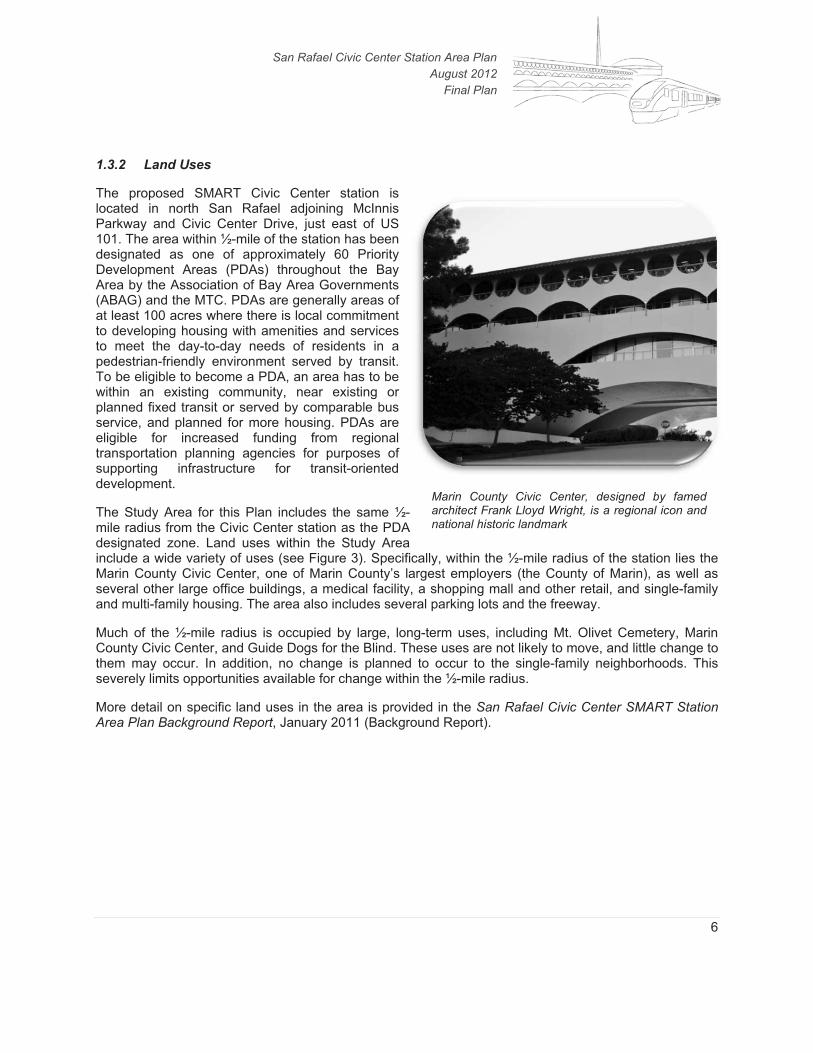
1.3.2 Land Uses
The proposed SMART Civic Center station is located in north San Rafael adjoining McInnis Parkway and Civic Center Drive, just east of US 101. The area within ½-mile of the station has been designated as one of approximately 60 Priority Development Areas (PDAs) throughout the Bay Area by the Association of Bay Area Governments (ABAG) and the MTC. PDAs are generally areas of at least 100 acres where there is local commitment to developing housing with amenities and services to meet the day-to-day needs of residents in a pedestrian-friendly environment served by transit. To be eligible to become a PDA, an area has to be within an existing community, near existing or planned fixed transit or served by comparable bus service, and planned for more housing. PDAs are eligible for increased funding from regional transportation planning agencies for purposes of supporting infrastructure for transit-oriented development.
The Study Area for this Plan includes the same ½-mile radius from the Civic Center station as the PDA designated zone. Land uses within the Study Area include a wide variety of uses (see Figure 3). Specifically, within the ½-mile radius of the station lies the Marin County Civic Center, one of Marin County’s largest employers (the County of Marin), as well as several other large office buildings, a medical facility, a shopping mall and other retail, and single-family and multi-family housing. The area also includes several parking lots and the freeway.
Much of the ½-mile radius is occupied by large, long-term uses, including Mt. Olivet Cemetery, Marin County Civic Center, and Guide Dogs for the Blind. These uses are not likely to move, and little change to them may occur. In addition, no change is planned to occur to the single-family neighborhoods. This severely limits opportunities available for change within the ½-mile radius.
More detail on specific land uses in the area is provided in the San Rafael Civic Center SMART Station Area Plan Background Report, January 2011 (Background Report).
Marin County Civic Center, designed by famed architect Frank Lloyd Wright, is a regional icon and national historic landmark

FIG
UR
E 1
Janu
ary
2012
EXIS
TIN
G L
AN
D U
SEFI
GU
RE 3
Not
to S
cale
SF10
-050
7 Sa
n Ra
fael
Civ
ic C
ente
r SA
P\D
eliv
erab
les\
Stat
ion
Are
a Pl
an R
epor
t\G
raph
ics_
Fina
l_Re
port
n
San Rafael Civic Center Station Area Plan August 2012
Final Plan
8
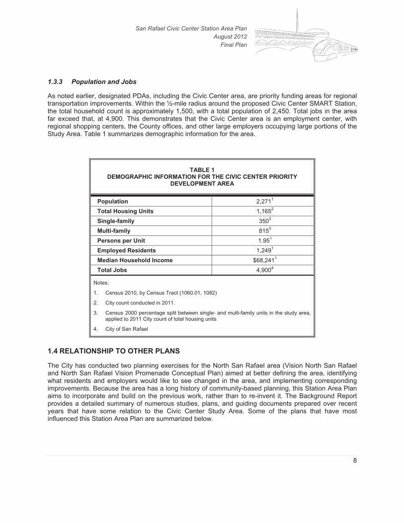
1.3.3 Population and Jobs
As noted earlier, designated PDAs, including the Civic Center area, are priority funding areas for regional transportation improvements. Within the ½-mile radius around the proposed Civic Center SMART Station, the total household count is approximately 1,500, with a total population of 2,450. Total jobs in the area far exceed that, at 4,900. This demonstrates that the Civic Center area is an employment center, with regional shopping centers, the County offices, and other large employers occupying large portions of the Study Area. Table 1 summarizes demographic information for the area.
TABLE 1 DEMOGRAPHIC INFORMATION FOR THE CIVIC CENTER PRIORITY
DEVELOPMENT AREA
Population 2,2711
Total Housing Units 1,1652
Single-family 3503
Multi-family 8153
Persons per Unit 1.951
Employed Residents 1,2491
Median Household Income $68,2411
Total Jobs 4,9004
Notes:
1. Census 2010, by Census Tract (1060.01, 1082)
2. City count conducted in 2011.
3. Census 2000 percentage split between single- and multi-family units in the study area, applied to 2011 City count of total housing units
4. City of San Rafael
1.4 RELATIONSHIP TO OTHER PLANS
The City has conducted two planning exercises for the North San Rafael area (Vision North San Rafael and North San Rafael Vision Promenade Conceptual Plan) aimed at better defining the area, identifying what residents and employers would like to see changed in the area, and implementing corresponding improvements. Because the area has a long history of community-based planning, this Station Area Plan aims to incorporate and build on the previous work, rather than to re-invent it. The Background Report provides a detailed summary of numerous studies, plans, and guiding documents prepared over recent years that have some relation to the Civic Center Study Area. Some of the plans that have most influenced this Station Area Plan are summarized below.

San Rafael Civic Center Station Area Plan August 2012
Final Plan
9
1.4.1 San Rafael General Plan 2020
The San Rafael 2020 General Plan serves as the comprehensive long-term plan for the community’s growth and development. The General Plan includes some goals and policies relevant to the Civic Center Station, including:
� In the Housing Element (H-22), the General Plan encourages infill near transit, allowing higher densities at transfer points.
� In the Neighborhoods Element (NH-88), the General Plan supports construction of the Civic Center SMART station, encouraging “a plan that provides higher density housing, bus transit connections, a parking lot, and incorporates pedestrian facilities and bicycle access (including bicycle storage facilities) consistent with the San Rafael Bike and Pedestrian Master Plan.”
� The Neighborhoods Element (NH-105) also encourages use of the unused portions of the SMART right-of-way “to facilitate desired redevelopment of adjacent parcels and an easement for the North-South bikeway.”
The Civic Center Station Study Area generally has a floor area ratio (FAR) designation of 0.30 for commercial uses, meaning that total building floor area can be no more than 30 percent of the parcel size. Residential uses, with a density of 44 units per acre, are also allowed in areas with General Commercial General Plan designations. The General Plan also includes a building height limit of 36 feet in Commercial areas and 30 feet for single-family residential in the Study Area.
1.4.2 Vision North San Rafael
In the spring of 1996, the City of San Rafael initiated a community visioning process to plan for the future of City areas in North San Rafael, defined as being north of Puerto Suello Hill. The City Council and citizens started the effort to learn more about what the people who live, work, and play in North San Rafael would like for their community in the year 2010. Vision North San Rafael is a description of what the community would like North San Rafael to be like in the future. People who live, work, shop or own property in the area helped shape the vision described in this document.
The document identifies various actions and implementation strategies that guide the community in achieving their goals. The community-identified vision concepts for the area were included in this Station Area Plan, especially the desire to complete a bicycle and pedestrian pathway through the area, connecting major destinations.
1.4.3 North San Rafael Vision Promenade Conceptual Plan
The North San Rafael Vision Promenade Conceptual Plan was adopted in November 2002. The plan proposes the following:
� Improved bicycle and pedestrian linkages between the Terra Linda Recreation Center and Lagoon Park at the Marin County Civic Center
� Amenities such as improved public parks and new plazas
� A repeating and unifying theme which reflects cultural elements, people, local natural history and expresses the community identity of North San Rafael through use of consistent "theme details"

San Rafael Civic Center Station Area Plan August 2012
Final Plan
10
The plan presents a detailed list of pedestrian paths and bikeways, amenities, and unifying themes with specific cross-sections and design elements proposed. The report was a result of an extensive public outreach effort and represents a community consensus. The mission of the plan reads as follows:
To develop a bicycle/pedestrian Promenade that connects the east and west sides of North San Rafael and offers new recreational opportunities and enhanced community identity.
This mission has been incorporated into the Station Area Plan.
Specifically, the North San Rafael Promenade proposes to improve the pedestrian and bicycle route that runs east/west through Terra Linda from Freitas Parkway to the Marin Civic Center lagoon. The promenade varies from an on-street bicycle lane and sidewalk to a landscaped dedicated multi-use path. The design features present a unified plan for enhancing the pedestrian and bicycle experience. Figure 4 illustrates the plan for completion of the Promenade.
1.4.4 Marin County Civic Center Master Design Guidelines
The Civic Center Master Design Guidelines were created to provide a framework for future development at the Civic Center. A key component was analysis and recommendations of sites for future development. The guidelines recommend that several sites remain in consideration as locations for possible future development and for further evaluation. The Guidelines also outline approaches to enhance pedestrian and bicycle circulation, public transportation, vehicular circulation and parking within the Civic Center. Recommendations include:
� Striped bike lanes on Civic Center Drive and other primary streets
� Additional bus service to the Civic Center on evenings and weekends
� Coordination with and support of the SMART project
� Restriping of Civic Center Drive / Peter Behr Drive
1.4.5 Marin Center Master Plan
The Marin Center Master Plan is also known as a “Vision” plan as it was completed through a public-private group called the Marin Center Renaissance Partnership. The Marin County Board of Supervisors never formally adopted this Vision, no funding has ever been identified (estimated at the time to be $130-150 million), and no environmental review has been completed. While the Marin Center Master Plan does not impose any requirements on the area, its recommendations and findings were considered as this Station Area Plan was developed.
The Marin Center is located within the Marin County Civic Center, and is comprised of the Marin Veterans’ Memorial Auditorium, Exhibit Hall, Showcase Theater, Fairgrounds and Lagoon Park. This 80-acre site is bound by Gallinas Creek to the north and the Civic Center Lagoon to the south. Gallinas Creek flows eastward to the San Francisco Bay.

NO
RTH
SA
N R
AFA
EL P
ROM
ENA
DE
PLA
NFI
GU
RE 4
Not
to S
cale
SF10
-050
7 Sa
n Ra
fael
Civ
ic C
ente
r SA
P\D
eliv
erab
les\
Stat
ion
Are
a Pl
an R
epor
t\G
raph
ics_
Fina
l_Re
port
n

San Rafael Civic Center Station Area Plan August 2012
Final Plan
12
The Marin Center Master Plan was completed in 2005 with the goal of establishing the Marin Center as the community center of the county. The preferred conceptual design discussed in the Master Plan proposes to eliminate the drop off area by the Auditorium building in order to increase the open space around the lagoon. The Avenue of the Flags would become the main entry to the site, and a new vehicular drop off area would be located adjacent to the auditorium and exhibit hall. The Master Plan also proposes to connect the Marin Veterans’ Memorial Auditorium with the Exhibit Hall building with a new building.
1.4.6 City of San Rafael Bicycle and Pedestrian Master Plan
The San Rafael Bicycle and Pedestrian Master Plan was developed in order to both lay out general goals for the City with respect to promoting bicycle and pedestrian activity, but also as a detailed roadmap for implementing the larger vision. The Plan identified three primary goals:
1. Goal 1 - Bicycle Transportation: Make the bicycle an integral part of daily life in San Rafael, particularly for trips of less than five miles, by implementing and maintaining a bicycle facilities network, providing end-of-trip facilities, improving bicycle/transit integration, encouraging bicycle use, and making bicycling safer.
2. Goal 2 - Pedestrian Transportation: Encourage walking as a daily form of transportation in San Rafael by completing a pedestrian network that accommodates short trips and transit, improves the quality of the pedestrian environment, and increases pedestrian safety and convenience.
3. Goal 3 - Model Community: Make San Rafael a model community for nonmotorized transportation. Aim for an increase from the current estimated five percent mode share to a twenty percent mode share of all utilitarian trips to be made by bicycling and walking by the year 2030.
Each of these goals reflects an overarching desire to greatly increase the percentage of trips made by bicycling and walking, thereby reducing automobile use. The Plan recognizes that achieving these goals will require strategic investment in bicycle and pedestrian infrastructure, and identifies a series of improvements that the City intends to pursue. The Plan proposes a continuous network of bikeways for travel within San Rafael and to surrounding communities. Routes are designated either “north-south” or “east-west.” North-south routes have odd numbers, and east-west routes have even numbers. Detailed discussion of specific proposals in the North San Rafael area is provided in Chapter 3.
1.4.7 Summary
The Station Area Plan respects the vast amount of input and visioning already provided by the community in the North San Rafael area. The plans described above are some of the major sources of community input already gathered in this area. To that end, specific recommendations, such as the desire to improve bicycle and pedestrian connections, specifically including the Promenade, were incorporated to the extent possible. The Station Area Plan is consistent with and builds upon already adopted plans.
San Rafael Civic Center Station Area Plan August 2012
Final Plan
13
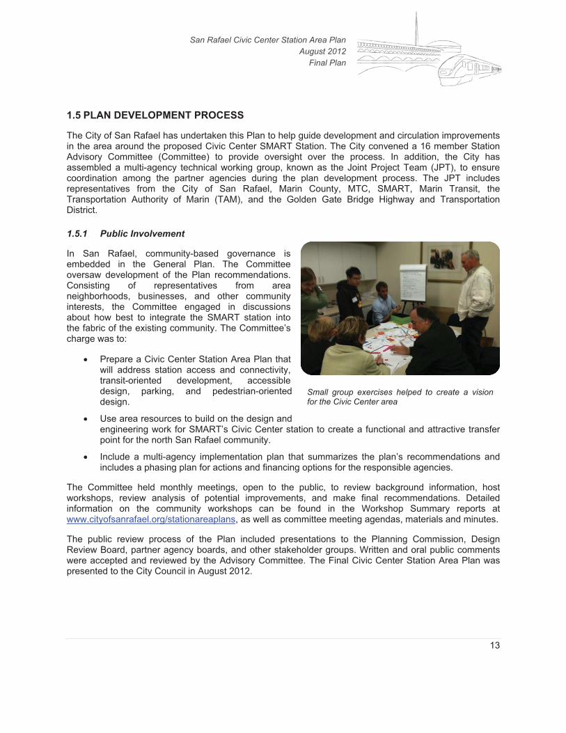
1.5 PLAN DEVELOPMENT PROCESS
The City of San Rafael has undertaken this Plan to help guide development and circulation improvements in the area around the proposed Civic Center SMART Station. The City convened a 16 member Station Advisory Committee (Committee) to provide oversight over the process. In addition, the City has assembled a multi-agency technical working group, known as the Joint Project Team (JPT), to ensure coordination among the partner agencies during the plan development process. The JPT includes representatives from the City of San Rafael, Marin County, MTC, SMART, Marin Transit, the Transportation Authority of Marin (TAM), and the Golden Gate Bridge Highway and Transportation District.
1.5.1 Public Involvement
In San Rafael, community-based governance is embedded in the General Plan. The Committee oversaw development of the Plan recommendations. Consisting of representatives from area neighborhoods, businesses, and other community interests, the Committee engaged in discussions about how best to integrate the SMART station into the fabric of the existing community. The Committee’s charge was to:
� Prepare a Civic Center Station Area Plan that will address station access and connectivity,transit-oriented development, accessible design, parking, and pedestrian-oriented design.
� Use area resources to build on the design and engineering work for SMART’s Civic Center station to create a functional and attractive transfer point for the north San Rafael community.
� Include a multi-agency implementation plan that summarizes the plan’s recommendations and includes a phasing plan for actions and financing options for the responsible agencies.
The Committee held monthly meetings, open to the public, to review background information, host workshops, review analysis of potential improvements, and make final recommendations. Detailed information on the community workshops can be found in the Workshop Summary reports at www.cityofsanrafael.org/stationareaplans, as well as committee meeting agendas, materials and minutes.
The public review process of the Plan included presentations to the Planning Commission, Design Review Board, partner agency boards, and other stakeholder groups. Written and oral public comments were accepted and reviewed by the Advisory Committee. The Final Civic Center Station Area Plan was presented to the City Council in August 2012.
Small group exercises helped to create a vision for the Civic Center area

San Rafael Civic Center Station Area Plan August 2012
Final Plan
14
CHAPTER 2. VISION FOR THE STATION AREA
The Committee developed their vision for the Civic Center Station Area. It states the community desires for the Station Area, and agreement on what the future of the area could be when SMART is in operation. It is the basis for detailed use, design and connectivity plans and projects to be developed in the future to move toward the desired Station Area. And it is the framework for the many public and private actions needed to achieve the vision.
Meet me at the station!
It’s 2035, over twenty years after the completion of the Civic Center Station Area Plan. This area is a vibrant and popular destination for North San Rafael residents and visitors. The station is a central hub for connecting to a wide variety of local activities, cultural and natural, including the seat of Marin County government at the landmark Frank Lloyd Wright Civic Center building, Veterans’ Memorial Auditorium, lagoon and grounds.
The train station fits well into its niche below the freeway and adjacent to the surrounding neighborhoods. Connecting paths, sidewalks and streets are comfortable, beautifully landscaped and artfully well-lit. There are places to park cars, scooters and bicycles, charge electric vehicles, and rent a bike. People are waiting in comfort for a train or bus, or just enjoying a cup of coffee and the great views of the distinctive rolling hills. There is housing nearby for people who work in the community. A public plaza near the station is a lively local gathering place.
With respect for Marin’s landscape, the area is planted with a wide variety of native plants and trees. A small fork of Gallinas Creek that flows through the station delights everyone with its ever-changing parade of wildlife. The whole area feels open and park-like; it’s easy to tell that the natural environment is appreciated and important to the community.
The station is at the center of a culturally and economically thriving and diverse community. The new jobs in the transit oriented development are filled by employees who walk, bike, and take the train to work and no longer have to drive. The Marin Farmer’s Market has grown into a full-scale daily shopping market, where fresh, locally grown organic produce, crafted cheeses, and quality goods of all kinds can be quickly picked up on the way home from the train.
While the station area is bustling with activity and land uses have become more intensive, it still maintains a hometown feel. New development has been carefully constructed to enhance sightlines and views of the Civic Center campus and the surrounding hills and to co-exist with established neighborhoods. There are shops, coffee houses, restaurants, and convenience stores in the station area. Residents and businesses both benefit from having people and needed services within walking distance.
It is safe and easy to get from place to place. Multiple ways to travel are fully integrated and cars no longer dominate. Frequent bus and shuttle services help keep distant areas connected. Bikes, moms with strollers, and pedestrians enjoy easy access to their destinations thanks to thoughtful design changes. The North San Pedro Road underpass, the Merrydale Overcrossing, and the station crossing are all pleasant places to experience views of the community and the hills.
To the west, the completed Promenade is an important connection for pedestrian and cyclists from the Station to the Northgate Mall and on to the heart of Terra Linda. Folk of all ages enjoy stopping to relax

San Rafael Civic Center Station Area Plan August 2012
Final Plan
15
and watch the steelhead salmon that have returned to the beautifully restored Gallinas Creek. To the east, walkways and bikeways stretch all the way to the Civic Center.
The area also offers a variety of housing types for all incomes including housing affordable for the local workforce. The simple, elegantly-designed affordable units have allowed young people to remain in Marin, bringing a new vibrancy into the social fabric. Seniors also find these smaller homes near services and transit especially convenient and desirable.
The changes made to this neighborhood center around North San Rafael’s new train center have made it an even more enjoyable place.