clarke county historical association
TRANSCRIPT

Clarke County Historical Association
PROCEEDINGS
Volume XXVIII
2012

2
Proceedings is published by the Clarke County Historical Association (CCHA), a
non‐profit organization founded in 1938 to preserve the history of Clarke County.
Proceedings is mailed to the members of the Association and is shared with sub‐
scribing libraries. Current and available previous issues are available on sale at the
CCHA Museum in Berryville, VA.
The mission of the Clarke County Historical Association is to foster, encourage,
and support the stewardship and use of Clarke County's significant historical re‐
sources, to include the discovery, collection, preservation, and publication of the his‐
tory, historical records, and data pertaining to Clarke County.
Membership in the Association is open to all. Dues and contributions are tax
deductible. Inquiries regarding membership, publications, and activities of the CCHA
should be directed to Clarke County Historical Association, PO Box 306, Berryville,
VA 22611; by phone (540)955‐2600, or email [email protected]. For more
information visit our website at www.clarkehistory.org.
The CCHA welcomes submissions to future editions of Proceedings. Submis‐
sions must relate to the history of Clarke County, Virginia.
Copyright 2012, Clarke County Historical Association, Inc.
Proceedings XXVIII, 2012

3
Contents
Officers, Board of Directors of the Association ………………………….. 4
Membership ……………………..…………………………………………….………...5
Report for 2012 ……………………………...…………….…………..……………… 7
Patriot Graves:
Final Resting Places of Our Revolutionary War Heroes….…….……8
By E. Ralph Pierce
Mount Weather:
The Long and Winding History of a Blue Ridge Landmark ……...23
By Maral S. Kalbian and Margaret T. Peters
Roots of a Clarke County Treasure………..………....…….....…………...45
Adapted from the Blandy Experimental Farm
“Phase 1 Archeological Investigations” conducted and
prepared by Rivanna Archeological Services of Charlottesville, Virginia

4
Clarke County Historical Association
Board of Directors
Howard Means – President
Douglas Bartley – Vice‐President
Maral Kalbian ‐ Secretary
Lucia Henderson – Treasurer
John Lincoln
Board Members Emeriti
Donald Cady Herman Lloyd
Suzanne McKown Mary Shockey
Historians Laureate
Matthew Mackay‐Smith Nancy St. Clair Talley
Don & Mary Royston
Staff
Laura Christiansen, Director
Mary Thomason Morris, Archivist
Don Wallace, Mill Manager
Carl Maples J.C. Moore
Joe Guenther Dev Morrison
Jon Joyce E. Ralph Pierce
Geraldine Kiefer Will Robinson
James Klenkar Don Wallace

5
Membership
(*=Life Member) Ms. Kory Apton
Mr. Ralph Apton
Mr. and Mrs. Thomas K. Armstrong * Mr. and Mrs. Edward Ashby Ms. Kathleen Ault Mr. James Avis Ms. Susan Bailey* Mr. Robert Ballard Mr. & Mrs. James E. Barb*
Mr. Richard E. Barnsback
Dr. Doug Bartley and Mr. Chris Bates* Mr. & Mrs. Hobart B. Bauhan* Mr. & Mrs. Tom Bazar Dr. and Mrs. Gerald Bechamps Mr. Stafford A. Bell Mrs. Katherine Tennery Bennett* Mr. and Mrs. John R. Berg* Mr. and Mrs. John Bieschke* Mr. Lewis T. Boxwell* Ms. Ledra Gordon Brady* Mr. Carl L. Brady Mr. Robert Brawley Mrs. Katharine C. Brown* Ms. Ann Barton Brown* Dr. and Mrs. Stuart E. Brown III* Mrs. Stuart E. Brown, Jr.* Mr. Jeremiah S. Buckley Ms. Kathy Burd Mr. & Mrs. Edward C. Burks
Mr. John F. Burridge Jr.*
Mrs. George W. Burton*
Mr. Charles Lee Burwell*
Dr. Belinda Burwell &
Mr. James Klenkar*
Ms. Nada Jill Butler*
Ms. Beverley Byrd &
Mr. Keith Harrington*
Mr. and Mrs. Harry F. Byrd III
Mr. and Mrs. Donald H. Cady*
Dr. David Connolly, Jr. Mr. & Mrs. James Coumes Mr. Fred S Crown, Jr., Ms. Barbara Digges Mr. & Mrs. Thomas Digges Mr. & Mrs. William H. Drury* Mr. & Mrs. Robinson M. Duncan* Mr. Victor S. Dunn* Mr. & Mrs. H. Robert Edwards* Mr. & Mrs. Robert A. Edwards*
Capt. James N. Edwards, Jr. Ms. Janet W. Eltinge Mr. Peter Elzer &
Ms. Anne Caldwell Mrs. Carol Everly* Mr. & Mrs. John F. Ewing*
Mr. & Mrs. Tim Farmer Mr. & Mrs. Patrick Farris Mr. & Mrs. Andrew U. Ferrari Mr. & Mrs. Brian Ferrell* Ms. Snow Fielding*
Harriett & David Condon
Ms. Mary H. Claycomb* Ms. Rebecca Rice‐Clay* Ms. Anne M. Clagett
Mrs. Ann Finch
Mr. & Mrs. Norman K. Fine
Dr. Martin P. Fleming
& Ms. Sarah French*
Mr. Mitch Franklin
Judge Carle F. Germelman Jr.*
Mr. Delio E Gianturco
Mr. Bruce Gilbert
Mr. Richard T. Gillespie
Mr. & Mrs. Thomas T. Gilpin
Mrs. McGhee Tyson Gilpin
Mr. & Mrs. Robert Calhoun
Mrs. Fritzie Carper
Ms. Mary O. Chatfield‐Taylor
Dr. & Mrs. Lionel Chisholm
Ms. Barbara Clagett
Mr. & Mrs. William Johnston* Mr. & Mrs. Joseph Johnston Mr. Peter M. Joost* Mr. & Mrs. Jon Joyce* Ms. Maral Kalbian* Mr. Edward J. Keenan* Mr. & Mrs. James Kelly Sr. Mr. & Mrs. Ken Kempson* Geraldine W. Kiefer, Ph.D* Mr. & Mrs. Kelly Kincannon*
Mrs. Jean King*
Mr. Robert Johnston*
Mr. & Mrs. Joseph W. Henderson*
Mr. Matt Hoff Mr. J. Michael Hobert, Esq.* Mr. & Mrs. Thomas Hill Ms. Marty Hiatt* Mr. Kimber S. Herron*
Mr. James Klenkar Mr. & Mrs. Gary Konkel* Mr. Daniel Koski‐Karell Ms. Mary Jane Lee* Ms. Jennifer Lee Mr. Stephen Lee* Mr. Edward A. Lee &
Ms. Monica Villegas* Mr. and Mrs. William H. Leedy* Mr. & Mrs. Stanley Legum* Mr. & Mrs. Robert G. Lesman Ms. Irmengard Lewis Mr. & Mrs. John P. Lewis Mr. Harry Lewis* Mr. & Mrs. John Lincoln* Ms. Celia S. Liner
Ms. Mary Grothe
Mr. & Mrs. F. Joseph Guenther*
Mr. & Mrs. Jimmie Harp* Ms. Jane Harris* Ms. Janna A. Hartsock
Mrs. Mack S. Headley Mr. & Mrs. Hugh Heclo Mr. Richard W. Hedges
Ms. Lavan Gray

6
Membership
(*=Life Member) Mr. Clinton Piper Mr. & Mrs. David Plater Mr. Arthur K. Pope Mr. David Ramsburg Mr. & Mrs. Robert Randolph Mrs. Catherine Page Raphael Mrs. Kay Reaume‐Johnson Mr. & Mrs. David Roberts Mr. Will Robinson Mr. Sam Robinson &
Ms. Marilu O'Byrne Mr. Mark Royston Mr. and Mrs. George Schember*
Mr. And Mrs. Bill Smith
Dr. Nicholas D. Snow &
Dr. Cathleen McCoy
Mr. Randy Sprouse*
Mr. & Mrs. John Staelin*
Colonel and Mrs. Duke Stanton
Mrs. Page Thomson Steele
Mr. William Steinmetz II*
Mr. and Mrs. Carl Stephanus*
Mr. and Mrs. Sidney L. Stern*
Mr. David Stickels*
Mr. Richard G. Stickels Jr.*
Mr. and Mrs. Scott Straub
Miss Scout Sullivan‐Fielding
Mr. and Mrs. Phillip Swing Thomas*
Mr. and Mrs. Dennis Tomsey*
Mr. and Mrs. Carl Tribble
Dr. Mary Triplette*
Mr. E. Hawley Van Wyck III*
Ms. Mary M. Bathory Vidaver
Mr. & Mrs. John Schutte
Mr. & Mrs. Charles H. Schutte Jr.
Mr. & Mrs. Robert Sellery, Jr.* Mr. John F. Sengewalt
Mr. & Mrs. John Sherman
Mr. John R. Milleson Ms. Mary Ann Milosavich Mr. J.C. Moore
Mrs. Norman deVere Morrison &
Family Mr. Reginald C. Morrison, Jr. Mr. Wolfgang Neudorfer Mr. Alex Newhart Mr. and Mrs. John Byrd Norris IV* Mr. & Mrs. George Ohrstrom II* Mrs. Romine Overbey Mrs. Sharon Painter Mr. George F. Patterson Mr. W. W. Peters* Ms. Kate Petranech Ms. Barbara Ann Petrov*
Mr. & Mrs. William McIntosh Mr. Branson McKay &
Mrs. Maral Kalbian Capt. Patsy McKelvy [Ret.] Mr. Michael J. McKenney Mrs. Suzanne McKown* Mr. & Mrs. William P. McLean Jr. Mr. & Mrs. Howard Means
Mrs. T. Haliburton McCoy* Dr. and Mrs. Martin Mayfield Mr. and Mrs. John Matticks
Ms. Marilyn J. Lister Mr. Herman B. Lloyd Mr. Russell Lloyd* Mr. & Mrs. Phil R. Lloyd Mr. & Mrs. Rudolf K. Loeser Mr. Jack R. Louthan*
Mr. Alastair S. MacDonald* Dr. and Mrs. Matthew Mackay‐
Smith* Ms. Adelaide G. MacLeod Ms. Jane B. Mandelbaum* Mr. & Mrs. Carl Maples
Mr. and Mrs. Tom L. Peyton, Jr.*
Mr. & Mrs. Edwin R. Pierce*
Mr. Doug Pifer
Ms. Laurie Volk* Mr. & Mrs. Robert Michael Walker* Mr. & Mrs. Don Wallace Mrs. Arthur Weiss* Mrs. Eugene V. White* Ms. Kenlynne K. White Mrs. Orme Wilson* Mr. & Mrs. Jim Wink
Mr. & Mrs. Thomas R. Wiseman II* Mr. Winston S. Wood Mr. Frank W. Wurzlow* Dr. & Mrs. James R. York* Mr. & Mrs. Paul T. Zeisset Thomas Balch Library

7
2012: Year in Review
At the beginning of 2012, CCHA set a goal of publishing the long‐overdue Volume
XXVIII of Proceedings, with the hope of returning to regular annual publication. Here is
that volume – filled with excellent, well‐researched, and useful articles. Much as the
first volume of Proceedings, published in 1941, continues to be of use to researchers
today, this volume is a lasting contribution to the preservation of the history of Clarke
county, one that will continue to be of use far into the future.
2012 also saw other goals of the Association achieved through the combined ef‐
forts of our dedicated members, directors, staff, and others. A successful capital cam‐
paign raised funds that enabled long overdue work on the Burwell‐Morgan Mill, includ‐
ing the installation of much‐needed gutters and repair work on the windows. Our ar‐
chives and artifact collections grew by leaps and bounds with the accession of a fantas‐
tic collection of Civil War and Paleo‐Indian artifacts collected by Brother James of Holy
Cross Abbey as well as over 200 other items. Doug Bartley and Maral Kalbian collabo‐
rated on an excellent exhibition, The Barns of Clarke County. Our annual Art at the Mill
shows drew record numbers both in the spring and in the fall, and along with the sec‐
ond annual celebration of Heritage day, introduced hundreds of new visitors to the
Mill.
CCHA now looks forward to new opportunities. In the coming year, we plan not
only to see the publication of Volume XXIX of Proceedings, but also to renew a portion
of our excellent museum space to enable changing exhibitions. We hope, too, to ex‐
pand educational programming and offer new opportunities to engage others in pre‐
serving and learning about our shared history. As we have done with this volume of
Proceedings, we hope to renew our dedication to our mission and to continue to make
lasting contributions to the stewardship of Clarke County’s significant historical re‐
sources.
Join us as we work toward these goals in 2013. There are many ways you can
support CCHA : donate, volunteer, visit the museum and the Mill, or consider submit‐
ting work for a future volume of Proceedings. Your membership and support are neces‐
sary and appreciated.
Thank you.

8
Grave of Peter Hunsicker, Stones Chapel
An appendix to Patriot Graves: Final Resting Places of Our Revolutionary War He-roes featuring photographs, location, and additional information for each grave listed is available online. To access the appendix, or for more information, please visit the Clarke County Historical Association website at www.clarkehistory.org.

9
Patriot Graves
Final Resting Places of
Our Revolutionary War Heroes
By E. Ralph Pierce
Clarke County Historical Association
Approximately 65,000 Virginians served in the American Revolution.1 Many other Virginians in some way
provided material support to the Revolution. Many residents of Frederick County served the patriotic cause. The
connection of General Daniel Morgan to the area is well known; his organization of the Morgan Riflemen and
their march to Boston to help the patriotic cause, is well documented. 2 Many of those patriots, including
Morgan, were from the area that now comprises Clarke County.
Support for the Revolution was indeed very strong in old Frederick County. A measure of that support is
preserved in a diary entry made by Philip Fithian, an itinerant Presbyterian clergyman. On June 6, 1775, while
visiting Winchester, Fithian wrote,
“… Mars, the great God of Battle, is now honored in every part of this spacious
Colony , but here every Presence is war‐like, every Sound is martial! Drums beating,
Pipes and Bag‐Pipes playing, and only sonorous and heroic Tunes == Every man
Has a hunting‐shirt, which is the Uniform of each Company == Almost all have a
Cockade and bucks‐tale in their Hats to represent that they are hardy, resolute,
and invincible Natives of the Woods of America.” 3
Those men indeed went off to engage in a long and hard, almost unwinnable, struggle for freedom.
Many of the men, who answered the call to serve, returned to their homes after the war. They resumed
their lives as farmers, as merchants, as husbands and fathers. Upon their deaths, they were buried in the locality
where they lived; either in church or private cemeteries. Many of those patriot gravesites are located in Clarke
County. This article will examine the history regarding what is known about the location of these gravesites, as
well as the service the patriots buried there performed for the cause of freedom.
10
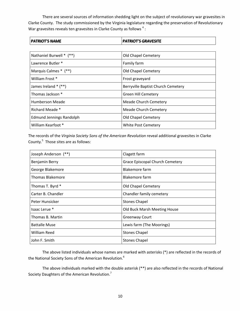
There are several sources of information shedding light on the subject of revolutionary war gravesites in
Clarke County. The study commissioned by the Virginia legislature regarding the preservation of Revolutionary
War gravesites reveals ten gravesites in Clarke County as follows 4 :
The records of the Virginia Society Sons of the American Revolution reveal additional gravesites in Clarke
County.5 Those sites are as follows:
The above listed individuals whose names are marked with asterisks (*) are reflected in the records of
the National Society Sons of the American Revolution.6
The above individuals marked with the double asterisk (**) are also reflected in the records of National
Society Daughters of the American Revolution.7
PATRIOT’S NAME PATRIOT’S GRAVESITE
Joseph Anderson (**) Clagett farm
Benjamin Berry Grace Episcopal Church Cemetery
George Blakemore Blakemore farm
Thomas Blakemore Blakemore farm
Thomas T. Byrd * Old Chapel Cemetery
Carter B. Chandler Chandler family cemetery
Peter Hunsicker Stones Chapel
Isaac Lerue * Old Buck Marsh Meeting House
Thomas B. Martin Greenway Court
Battalle Muse Lewis farm (The Moorings)
William Reed Stones Chapel
John F. Smith Stones Chapel
Nathaniel Burwell * (**) Old Chapel Cemetery
Lawrence Butler * Family farm
Marquis Calmes * (**) Old Chapel Cemetery
William Frost * Frost graveyard
James Ireland * (**) Berryville Baptist Church Cemetery
Thomas Jackson * Green Hill Cemetery
Humberson Meade Meade Church Cemetery
Richard Meade * Meade Church Cemetery
Edmund Jennings Randolph Old Chapel Cemetery
William Kearfoot * White Post Cemetery
PATRIOT’S NAME PATRIOT’S GRAVESITE
11
The organizations accumulating the above lists used records of local historical associations, pension and
land grant records and other sources. Some of the information supporting the above lists of patriots is very old;
this article will endeavor to update the lists with current information. It is the writer’s intention to build upon the
conscientious work done by others in the past to locate and preserve these Revolutionary War patriot graves. The
writer, moreover, does not represent that the above listings are a complete listing of revolutionary war patriots
buried in Clarke County.
If any inaccuracies in the above list are found they will be corrected. In the event the writer makes
mistakes in his conclusions, or omits significant information, he apologizes in advance. The writer, moreover, will
not attempt a detailed biographical sketch of each patriot, but will confine comment to what services the patriot
rendered the cause of freedom. It should be noted an Appendix to this paper contains GPS readings for most of
the graves herein discussed; there are also, where appropriate, photographs of these graves. 8
At the onset, several of the above listed graves will not be considered In this article. There is no grave
marker in the Old Chapel Cemetery for MARQUIS CALMES, who died just prior to the French and Indian War. Both
he and his wife, Winifred, were buried on the family plantation, the Vineyard. A flood destroyed Marquis’s grave
ledger, and his wife’s stone was later moved to the Old Chapel Cemetery. 9
There are no other CALMES buried at Old Chapel. MARQUIS CALMES IV was the Revolutionary War
patriot most likely considered by the persons who developed the above list of patriot. MARQUIS CALMES IV,
however, left Virginia after the war, and migrated to Kentucky where he is buried. 10 The listing of MARQUIS
CALMES as a patriot buried in Clarke County therefore appears to be in error.
Similarly, the grave of THOMAS TAYLOR BYRD is eliminated from consideration because he was not a
patriot during the Revolutionary War. The patriot graves listed above erroneously included him in the listing of
patriots; BYRD actually served as a Captain in the British Army during the Revolutionary War. 11
Two additional names will also not be considered further. The writer neither could find the grave of
HUMBERSON MEADE in the cemetery at the Meade Memorial Church in White Post, nor was the name familiar to
the Clarke County Historical Association.12 Finally, further investigation revealed, the grave of BATTAILLE MUSE is
physically located in Jefferson County West Virginia, 13 and therefore will not be addressed in this article.
Old Chapel
Colonel Nathaniel Burwell – Appendix, #5 (App., #5)
There are two very significant Revolutionary War patriot gravesites in Old Chapel. The first such
gravesite is that of COLONEL NATHANIEL BURWELL, the builder of Carter Hall, and along with General Morgan, the
Burwell‐Morgan Mill in Millwood, Virginia. The BURWELL grave, which is readily accessible, reveals COLONEL
BURWELL was born in 1750 and died in 1814.14 COLONEL BURWELL’S original grave ledger had been damaged and
was replaced with a new one in 2010.
12
In 1774, COLONEL BURWELL, who was originally from the area around Williamsburg, became a member
of the James City County Committee of Safety. In November 1776, he was appointed Chief Military Officer of
James City County in command of 190 militiamen. COLONEL BURWELL also saw to it his county’s “full proportion”
of recruits was supplied the continental army.15
COLONEL BURWELL may have seen action when the British invaded the “Tidewater” area. He also was
probably at Yorktown with his men as part of the 4000 militiamen serving in General Washington’s army.16 He
further demonstrated support for the Revolutionary by supplying the Continental Army with the use of wagons,
and 3972 lbs of beef.17
Edmund Jennings Randolph – App., #14
The second patriot grave at Old Chapel is that of EDMUND JENNINGS RANDOLPH. The RANDOLPH grave
is, also well marked. It reveals he was born in 1753 and died in 1813.18 RANDOLPH served as an aide‐de‐camp to
General Washington for a short time after the Battle of Bunker Hill.19 Upon his return to Virginia he served the
patriot cause in a civilian capacity.
RANDOLPH served on the Committee that drafted the Virginia Declaration of Rights and the first Virginia
Constitution; during the Revolution he also served as state attorney general. After the Revolution, he served as
Governor of Virginia, and as a member of the Continental Congress. RANDOLPH was the first Attorney General of
the United States, and served as well as Secretary of State. 20
Meade Memorial Episcopal Church Cemetery, White Post
Colonel Richard Kidder Meade – App., #13
COLONEL RICHARD KIDDER MEADE now rests at the Meade Memorial Episcopal Church Cemetery. His
monument reveals he was born July 11, 1746 and died February 9, 1805.21 It is noted that MEADE is said to have
originally been buried at his plantation home “Lucky Hit,” which home be built after the revolution, and was later
moved to the cemetery in White Post.22 His monument is easily found in the cemetery, and is cared for well.
MEADE served the cause for freedom from October 24, 1775 until the end of the Revolution. He served
as a captain in the 2nd Virginia Regiment; he later was appointed to General Washington’s staff and served in all
the important battles of the war. He concluded his war service assisting General von Steuben in the Virginia
theatre of operations until the end of the war. 23

13
Stones Chapel
William Reed – App., #15
Many of the citizen soldiers of the Revolution were just ordinary settlers of the lands west of the Blue
Ridge. WILLIAM REED was such a person. REED’S gravestone in the Stones Chapel Cemetery reveals he died on
September 4th, 1839 at the age of 77.24 The cemetery cares for his gravesite and maintains it well.
REED served as a sergeant in the 8th Virginia Regiment. He was in the company called Buck’s Minute
Men, after the company commander Captain Thomas Buck.25 The non‐commissioned officers and privates of the
company in which REED served carried a rifle, bayonet, powder horn, cartouche and tomahawk. The same
weapons they used to settle the land for which they then fought.
John Fredrick Smith – App., #16
JOHN FREDERICK SMITH is another citizen soldier buried at Stones Chapel Cemetery. SMITH’S
gravestone reveals he died at age 54 years, on October 29, 1812.26 His name is apparent on his gravestone, and
the Chapel maintains his gravesite well. It is believed SMITH was born in Frederick County, Virginia in 1761.
SMITH enlisted as a private in Capt. Peter Byron Bruin’s company, 11th Virginia Regiment, commanded
by Col. Daniel Morgan.27
Peter Hunsicker – App., #8
PETER HUNSICKER gravestone reveals only that he died at the age of 55, in 1816.28 HUNSICKER’S
gravestone is in need of repair, but the Chapel has preserved all parts of the monument for needed maintenance.
PETER’S father, DANIEL HUNSICKER, is probably also buried Stones Chapel, but his grave is lost to time.29
DANIEL HUNSICKER served as a Lieutenant Colonel during the French and Indian War. PETER lived with
his father on the farm of the later during the time of the Revolution.30
During the conflict, however, the HUNSICKERS did not serve in the military. They rather provided
material support to the fight for freedom by providing provisions to support the Continental Army, which included
261 pounds of Flour.31
14
Private Cemeteries
Joseph Anderson – App., #1
There are several private cemeteries in Clarke County where Revolutionary War patriots are buried.
One such gravesite is in the Anderson Graveyard on the Clagett farm, “Springfield,” where patriot JOSEPH
ANDERSON is buried. Unfortunately, this patriot’s gravestone is no longer visible.
We know from records dating to 1941 that the inscription on ANDERSON’S stone read “Sacred to the
memory of JOSEPH ANDERSON who departed this life Jan. 23, 1825, aged 78 years, 10 mos. And 27das.” 31
Public Service claims reveal JOSEPH ANDERSON was a patriot and furnished material aid to the revolutionary
war in the form of 18 gallons of whiskey. 32
George Blakemore & Thomas Blakemore – App., #s 3 & 4
Another private cemetery is located on the old Blakemore property. This property is now part of the
Byrd farm. This well maintained cemetery is reputed to be the largest private cemetery in Clarke County. Of the
several visible grave markers, one is that of GEORGE BLAKEMORE. The lettering on the stone is difficult to read,
but GEORGE BLAKEMORE’S name is clearly discernible. We know from past recording that BLAKEMORE was born
May 23, 1759 and died July 23, 1813.33
GEORGE BLAKEMORE’S military service during the American Revolution is quite interesting. He enlisted
in the 2nd Virginia Regiment when he was seventeen years old on December 19, 1776. During his time in service
he rose in rank from private, to corporal, to sergeant, to ensign and finally to lieutenant. He separated from the
army on April 5, 1782. 34
BLAKEM0RE served in both the Mid Atlantic and Southern theaters. He was at Germantown where his
fifteen‐year old brother, THOMAS BLAKEMORE, was mortally wounded; he was among the sick at Valley Forge;
and participated in other campaigns in that area.35 His regiment was sent South with General Green and he was
captured by the British in South Carolina. After being held captive on a British prison ship for approximately
thirteen months,’ BLAKEMORE was released and paroled. He was with his regiment at Yorktown when
Cornwallis surrendered.36
GEORGE BLAKEMORE became acquainted with General Lafayette during the Battle of Monmouth. He
subsequently served on Lafayette’s staff, and developed a life‐long friendship with the General. In 1824, on
Lafayette’s last visit to the United States, they visited with one another in Richmond. At that time, BLAKEMORE
informed the general that his family had named their eldest grandson Thomas Fayette Buck after the General.37
A final word is appropriate regarding GEORGE BLAKEMORE. A year before his death he returned to the
battlefield at Germantown where his younger brother THOMAS died. He met one of the men who had buried
THOMAS in a common grave along with four other continental soldiers; this man gave GEORGE a bullet from the
battlefield he later had encased in silver and attached to his watch chain. 38
15
The THOMAS BLAKEMORE listed in the sources above is not GEORGE’S brother THOMAS. The
Revolutionary War soldier, THOMAS BLAKEMORE, still lies buried on the Germantown Battlefield.39 Of the two
THOMAS BLAKEMORE gravesites in the Blakemore Cemetery, one belongs to the patriot soldiers’ father.
THOMAS BLAKEMORE SR. is also a patriot. In addition to giving his sons to the revolution, THOMAS
BLAKEMORE also gave material support to the cause of freedom by supplying the army with 144 lbs of mutton.40
Major Lawrence Butler – App., #6
Another private cemetery with a patriot grave is on the Dearmont farm. It is here that MAJOR
LAWRENCE BUTLER is buried. The BUTLER grave was “re‐found,” cleaned and restored in 2002.41 The grave
ledger reveals MAJOR BUTLER “D 4 May 1811, in the 56th year of his age.” MAJOR BUTLER was distinguished for
his philanthropy, integrity and an ardent patriotism.”42
BUTLER’S ledger also states that this patriot “During the entire period of the Revolutionary War …. held
a commission in the Army of the U.S. and was an intrepid and active defender of his’ country’s rights until he
became a prisoner at the memorable siege and capitulation of Charleston in S. C.” 43 He served first in the 15th
Virginia and later in the 11th Virginia; his ranking ranged from lieutenant, to captain and finally major.
There is independent corroboration of MAJOR BUTLERS’ service. Pension Records, as well as other
publications confirm his service during the Revolution but show him actually discharged from the Army in
1800.44 This retirement date conflicts with the statement on his ledger that after the peace treaty with Great
Britain “… he returned to the tranquil walks of private life.” 45 In any case, regardless of MAJOR BUTLER’S length
of military service he served his country during the Revolutionary War.
Carter B. Chandler – App., #7
CARTER B. CHANDLER is buried on the Helvestine farm. In 1941, his grave marker was observed to read
“Sacred to the memory of CARTER B. CHANDLER who departed this life Aug. the 16th A.D. 1813 in the79th year
of his age.”46 At that time, the cemetery was not well cared for, and the stones were nearly fallen over. Today,
the cemetery, which is in a remote part of the farm, is substantially overgrown, and the grave markers have
been moved to the side of a nearby barn. These markers are difficult to read. The Appendix contains the GPS
reading from the center of the cemetery.
CARTER B. CHANDLER’s exact military service during the Revolution is not known. In 1835, however,
relatives proved his service to the satisfaction of the County Court of Frederick County to allow for the issuance
of a land bounty.47
William Kearfoot – App., #11
WILLIAM KEARFOOT’S grave is on part of the old Wheeler farm, now called Deerfield. This patriots’
gravestone is now readable, at least to the extent of his name.48 The graveyard, now fenced and cared for by
the current property owners, is situated in a grove of trees near the house.

16
KEARFOOT served the full eight years of the war. He was a 1st Sergeant in Captains Stith’s Company, 4th
Virginia Regiment of the Continental Line.49 At one point during the war, either KEARFOOT or his father also
supplied the army with mutton.50
William Smith – App., #17
Another patriot said to be buried in the cemetery on the old Wheeler farm is WILLIAM SMITH. The
sources the writer used as a starting point for this article did not list SMITH, but his role as a patriot was
uncovered during research for this article. There is a very weathered gravestone in the cemetery that appears
to bear the initials “W. S.” Accordingly, this marker may well memorialize a long forgotten patriot of the
Revolution.
According to a record at the Handley Regional Library, WILLIAM SMITH served as a private in the
Frederick Militia, was a member of the expedition against Claypoole and at the siege of Yorktown. 51
Lost to the Ages
Thomas Jackson – App., #10
Some Revolutionary War patriot graves have been lost to the ages. The grave of THOMAS JACKSON is
an example of this type of patriot grave. JACKSON originally was buried in a private cemetery on the “Cherry
Hill” farm. In 1942, the graveyard was “… fenced, clean and well cared for, all stones clear and in position.”
Thereafter, JACKSON’S gravestone, along with others, was moved to Green Hill Cemetery in Berryville.
JACKSON’S gravestone still stands where it was placed in its new location in Berryville. It is inscribed, “In
memory of THOMAS JACKSON who departed this life Aug. 14, 1843, in the 84th year of his life.” The location of
the original cemetery where he was buried, and where his remains still rest, has been lost to time.
JACKSON was reputed to be a “… soldier of the Revolution, serving under Col. Gibson in the Companies
of Benjamin Biggs and Uriah Springer.”52 The writer, however, has not found corroboration for this contention.
Benjamin Berry – App., #2
Another grave lost to the ages is that of BENJAMIN BERRY. Purportedly, BERRY, the founder of
Berryville, is buried in the cemetery at Grace Episcopal Church. BERRY was commemorated by the placement of
a memorial stone in that church’s cemetery.53 However, it is not known where BERRY is exactly buried. The
historic marker on Main Street in Berryville states he is buried in the Northeast corner of the Grace Episcopal
Church cemetery (See, App. #2).54

17
Even if we are not sure of BERRY’S actual place of burial, we do know that he supported the
revolutionary cause by supplying the army with 375 lbs of beef.55
James Ireland – App., #9
The above source records show JAMES IRELAND buried in the Berryville Baptist Church Cemetery. This
contention, however, is in error. IRELAND is buried in the old Buck Marsh Baptist Church Cemetery, where he
served as pastor. His grave is neither marked, nor is its exact location known. A stone marker is in the field
marking where the church is believed to have been, with the cemetery nearby. (See, App. #9)
As an early Baptist preacher IRELAND was much persecuted for his preaching of the Gospel. In the
early years of the 1770’s, the established religious authorities with the assistance of the local sheriff imprisoned
him in Culpepper.56 After his release, IRELAND served as pastor of several churches, including the Buck Marsh
Baptist Church.
During the Revolution IRELAND was a patriot. The writer does not know the exact service IRELAND
provided the Revolution. IRELAND, however, is the patriot ancestor supporting the membership of two
members of the DAR.57 Perhaps he provided religious comfort to the troops, or provided material support to the
cause. Regardless of what he did, IRELAND stands as a symbol of the religious freedom the Revolution secured
for us.
Isaac Lerue – App., #12
Another patriot gave site has been lost to time in the Buck Marsh Baptist Church Cemetery. ISAAC
LERUE was buried at that location when he died at 83 years of age. His gravestone is lost to time and his
remains lay in a field outside of Berryville. 58
ISAAC LERUE is a patriot because he supplied the army with substantial material support. This patriot
furnished 2419 lbs of beef, 1756 lbs of flour, more than 150 lbs of bacon and pasturage for livestock.59
Thomas B. Martin
Another lost gravesite is that of THOMAS B. MARTIN. This patriot was purported buried in the
cemetery at Greenway Court. The Greenway Court Cemetery, of course, is nearby the home of Lord Fairfax in
White Post. To support the conclusion that MARTIN was buried at Greenway Court cemetery there was an 1879
letter (now lost in the annuls of time) that stated THOMAS BRYAN MARTIN (D 9/4/1798) was buried there.60
THOMAS B. MARTIN was also a patriot of the Revolution. He supplied material support to the army,
including among other supplies horses, corn, 24244 lbs of flour, 50 lbs of beef, the use of wagons and 121
gallons of whiskey.61
18
William Frost
From available records, WILLIAM FROST apparently was buried in the Frost Family Graveyard. That
cemetery was on the “Middle Farm” owned by Mrs. Lorenzo Lewis in 1941. At that time, “… nothing [was] left
to mark the spot [of the cemetery] except a few trees.” 62
WILLIAM FROST served as a captain in the Frederick County militia.63 He also supported the
revolutionary cause by supplying the army with substantial resource assistance. The commodities furnished by
FROST included, hay, bushels of corn and 880 lbs of beef.64
Conclusion
As we have seen, Clarke County indeed has a rich history during the era of the Revolutionary War.
While the combatants fought no battles in this area, its citizens widely supported the fight for independence.
Some citizens served the cause for freedom by serving in the military; some of these patriots gave their
life for that cause. Other citizens supported the cause by providing material support to the war effort.
Regardless of the service provided, these individuals are part of that heroic generation that gave us our
freedom.
The memory of those individuals contribution to our freedom in blood, sweat and fortune is still present
today in the form of their gravesites. It is our duty to these patriots to respect their sacrifices by preserving
these graves, as best we can. It is also our duty to be ever vigilant for the gravesite of any forgotten patriots.
We must never allow the passage of time to blur the contribution these patriots made with their service to our
country and their contribution to the freedom we now enjoy because of their sacrifices.
We need to ask, how many of our patriots served, or supported the cause for freedom; how many of
these patriots were buried in this county; and how many of their gravesites can we find and preserve? To find
those patriot graves and preserve them, as well as continue to preserve those we already know of, is the
greatest honor we can pay to our heritage.

19
Endnotes
1 Joint Legislative Audit and Review Commission of the Virginia General Assembly, Preservation of Revolutionary War Veteran
Gravesites, Commonwealth of Virginia, 2000, p. 1
2 T.K. Cartmell, Shenandoah Valley Pioneers and Their Descendants, (1909 reprint: The Apple Manor Press), pgs. 98 – 101. 3 Everard Kidder Meade, Notes On The History Of The Lower Shenandoah Valley, Proceedings of the Clarke County Historical
Association, Vol. XIV, 1956‐1957, (1958: The Carr Publishing Co. Inc.) , p. 56 4 JLAC Report, Appendix B‐2, pgs. 28‐29 5 Virginia Society Sons of the American Revolution, http://www.Virginia‐sar.org/vassar/revwargraves.htm 7/24/2012 6 National Society Sons of the American Revolution, “Patriot & Graves Index,” http://www.sar.org/search/node/patriot%20%2526%
20grave%20index 7/24/2012 7 Daughter of the American Revolution, Genealogical Research Databases, http://services.dar.org/public/dar_research/search/?
tab_id‐0 7/24/2012 8 The Appendix is available online. Please visit www.clarkehistory.org for access and more information. 9 Walter H. Buck, A Short Sketch Of The Calmes Family, Proceedings of the Clarke County Historical Association, Vol. X, 1950, pgs. 66‐
67 10 Buck, pgs. 69‐72 11 Report of the Graveyard Committee, Proceedings of the Clarke County Historical Association (CCHA), Vol. II, 1942, p. 6 12 The Clarke County Historical Association’s archivist, Mary Morris, was unfamiliar with the name HUMBERSON MEADE 13 Tombstone Inscriptions and Burial Lots compiled by Bee Lee Chapter, National Society Daughters of the American Revolution,
Tombstone Inscriptions Jefferson County West Virginia, (1981: Walsworth Publishing Co., Marceline, Mo.) 14 The Index of Old Chapel Cemetery, Proceedings of the Clarke County Historical Association, Vol. XVIII, (1976: Carr Publishing Co.
Inc., Boyce, Va.), p. 80 15 Stuart E. Brown, Jr. and Ann Barton, Carter Hall, (1978: Virginia Book Company), p. 3 16 Ibid. 17 Janice L. Abercrombie and Richard Slatten, Virginia Revolutionary “Publick” Claims, Volumes I I, (1992: Iberian Publishing Co.,
Athens, Ga.), pgs. 380 & 383 18 The Index of Old Chapel Cemetery, p. 95 19 Merrill Peterson, Edmund Randolph and His Times, Proceedings of the Clarke County Historical Association, Vol. XXI, 1979 – 1980,
(1980: The Blue Ridge Press, Berryville, Va.), pgs. 4‐5; See also, J.H. Gwathmey Historical Register, Virginia in Revolution 1775‐1783,
(2010 Reprint: Genealogical Publishing Co. Inc., Baltimore, Maryland), p. 649 20 Peterson, p. 6 ‐ 7 21 Don Royston & Mary Royston, Cemeteries of Clarke County, (2005: New Papyrus Publishing, Athens, Georgia), p. 55 22Rose M. E.MacDonald, Clarke County A Daughter of Frederick, Proceedings of the Clarke County Historical Association, Vol. XXIII,
1983‐1984, (1985: Commercial Press, Stephens City, Va.), p. 11 23 Valley Forge National Historical Park, Lt. Col. Richard Kidder Meade, http://www.nps.gov/vafo/historyculture/
richardkiddermeade.htm, 6/14/2012; and Gwathmey, p 54 24 Royston, p. 94 25 T.K. Cartmell, p. 101; See also, J.H. Gwathmey, p. 658 26 Royston, p. 95 27 Gwathmey, p. 722 28 Royston, p. 92

20
29 Richard Hopper, Hunsicker, Hunsucker, Hunsuker, Hunsecker, Hunsicker, Hansucker, Honsaker, and Huntsacie Family History, July
1997, p. 6 30 Ibid. pgs, 2‐6 31 Abercrombie and Slatten, p. 382 32 Report of the Graveyard Committee, Proceedings of the Clarke County Historical Association, Vol. I, 1941, p. 18 33 Abercrombie and Slatten, p. 378 34 Royston, p. 4 35 Heritage Quest Online, Blakemore, George, http://persi.heritagequestonline.com/hqoweb/library/do/revwar, 5/22/2012
Virginia Sullivan Bruch, PROUD WANDERS, My Mother’s Family ‐ ‐ HELM with Allied Lines: BLAKEMORE, BUCK. NEVILLE, Alexandria,
Virginia, 1988, p. 119 36 Ibid., pgs. 120‐121 37 Ibid., pgs. 121‐122 38 Ibid., p. 120 39 Ibid. 40 Abercrombie and Slatten, p. 382 41 Royston, p. 6
42 Report of the Graveyard Committee, Proceedings of the Clarke County Historical Association, Vol. II, 1942, p. 11 43 Ibid. 44 Ancestry.com, Revolutionary War Officers, Lawrence Butler, http://search.ancestry.com/cgi‐d11?
db=army&rank1&MSAV=1&msT=1, 6/23/2012 45 Proceedings of the Clarke County Historical Association, Vol. II, p. 11 46 Proceedings of the Clarke County Historical Association, Vol. I, p. 22 47 T.K. Cartmell, p. 114 48 Royston, p. 11 49 Ancestry.com ‐ Historical Register of Virginians in the Revolution, http://search.com/content/viewerpf.aspx?h=338664&db=FLHG‐
RegisterVARev... , 7/12/2012; See also, Julian Baker Papers, Revolutionary War and War of 1812, Soldiers Abstracts From Frederick
County Court Records, complied by Julian Baker, undated, Steward Bell Jr. Archives, Handley Regional Library, Winchester. VA 50Abercrombie and Slatten, p. 375 51 Handley Regional Library, Archives, Revolutionary War – Graves Sites in Frederick, Clarke and Warren Counties, undated, 575THL/
WFCHS 52 Proceedings of the Clarke County Historical Association, Vol. II, p.13 53 Royston, p. 34 54 The CCHA archivist, Mary Morris, stated no one is sure where BERRY is actually buried. 55 Abercrombie and Slatten, p. 382 56 Samuel Kercheval, A History of the Valley of Virginia, 6th edition, (1981: C. J. Carrier Co., Harrisonburg, VA.), p. 65 57 Daughters of the American Revolution, Genealogical Research Databases, http://services dar.org/public/dar_research/
search_adb/default.cfm, 7/16/2012 58 Mather, Otis M., Six Generations of LaRues And Allied Families, (1921: Press of C. T. Dearing Printing Company, Inc., Louisville,
Kentucky), p. 33 59 Abercrombie and Slatten, pgs. 383 & 386 60 Royston, p. 10 61Abercrombie and Slatten, pgs. 374, 379 & 381 62 Proceedings of the Clarke County Historical Association, Vol. I, p. 22 63 Julian Baker Papers, Revolutionary War and War of 1812, Soldiers Abstracts From Frederick County Court Records, complied by
Julian Baker, undated, Steward Bell Jr. Archives, Handley Regional Library, Winchester. VA,, p. 70 64 Abercrombie and Slatten, pgs. 378, 381, 382 & 383
21
Bibliography
Abercrombie, Janice L. and Slatten, Richard, Virginia Revolutionary “Publick” Claims, Volumes I – III, Iberian Publishing
Co., Athens, Ga. 1992
Ancestry.com, “Revolutionary War Officers”, Lawrence Butler, http://search.ancestry.com/cgi‐d11?
db=army&rank1&MSAV=1&msT=1, 6/23/2012
Brown, Stuart E., Jr. and Ann Barton, Carter Hall, Virginia Book Company, 1978
Bruch, Virginia Sullivan, PROUD WANDERS, My Mother’s Family ‐ ‐ HELM with Allied Lines: BLAKEMORE, BUCK. NEVILLE,
Alexandria, Virginia, 1988
Buck, Walter H., “A Short Sketch Of The Calmes Family”, Proceedings of the Clarke County Historical Association, Vol. X,
1950
Cartmell T.K., Shenandoah Valley Pioneers and Their Descendants, The Apple Manor Press, reprint of 1909 copy.
Crampton, Benjamin, “Report of the Graveyard Committee”, Proceedings of the Clarke County Historical Association,
Vol. I, 1941
Crampton, Benjamin, “Report of the Graveyard Committee”, Proceedings of the Clarke County Historical Association,
Vol. II, 1942
Daughter of the American Revolution, Genealogical Research Databases,
http://services dar.org/public/dar_research/search
Gwathmey, J.H., Historical Register, Virginia in Revolution 1775‐1783, Reprinted: Genealogical Publishing Co. Inc.,
Baltimore, Maryland, 2010
Heritage Quest Online, “Blakemore, George”, http://persi.heritagequestonline.com/hqoweb/library/do/revwar,
5/22/2012
Hopper, Richard, Hunsicker, Hunsucker, Hunsuker, Hunsecker, Hunsicker, Hansucker, Honsaker, and Huntsacie Family
History, July 1997
“The Index of Old Chapel Cemetery”, Proceedings of the Clarke County Historical Association, Vol. XVIII, Carr Publishing
Co. Inc., Boyce, Va. 1976
Joint Legislative Audit and Review Commission of the Virginia General Assembly (JLAC Report), Preservation of
Revolutionary War Veteran Gravesites, Commonwealth of Virginia, 2000
Julian Baker Papers, Revolutionary War and War of 1812, Soldiers Abstracts From Frederick County Court Records,
complied by Julian Baker, undated, Steward Bell Jr. Archives, Handley Regional Library, Winchester. VA
Kercheval, Samuel, A History of the Valley of Virginia, 6th edition, C. J. Carrier Co., Harrisonburg, VA, 1981
MacDonald, Rose M. E., “Clarke County A Daughter of Frederick” Proceedings of the Clarke County Historical Association,
Vol. XXIII, 1983‐1984, Commercial Press, Stephens City, Va. 1985, p. 8 – 14.
Mather, Otis M., Six Generations of LaRues And Allied Families, Press of C. T. Dearing Printing Company, Inc., Louisville,
Kentucky, 1921

22
Meade, Everard Kidder, “Notes On The History Of The Lower Shenandoah Valley”, Proceedings of the Clarke County
Historical Association, Vol. XIV, 1956‐1957, The Carr Publishing Co. Inc., Boyce Va., 1958
National Society Sons of the American Revolution, “Patriot & Graves Index,” http://patriot.SAR.Org
Peterson, Merrill, “Edmund Randolph and His Times”, Proceedings of the Clarke County Historical Association, Vol. XXI,
1979 – 1980, The Blue Ridge Press, Berryville, Va. 1980
Revolutionary War – Graves Sites in Frederick, Clarke and Warren Counties, 575THL/WFCHS, Stewart Bell Jr. Archives,
Handley Regional Library, Winchester, VA
Royston, Don & Mary, Cemeteries of Clarke County, New Papyrus Publishing, Athens, Georgia, 2005
Shenandoah Valley Military Records, 575 THL/WFCHS, Stewart Bell Jr. Archives, Handley Regional Library, Winchester,
VA
Tombstone Inscriptions and Burial Lots compiled by Bee Lee Chapter, National Society Daughters of the American
Revolution, Tombstone Inscriptions Jefferson County West Virginia, Walsworth Publishing Co., Marceline, Mo.
1981
Valley Forge National Historical Park, “Lt. Col. Richard Kidder Meade”, http://www.nps.gov/vafo/historyculture/
richardkiddermeade.htm, 6/14/2012
Virginia Society Sons of the American Revolution, http://www.Virginia‐ SAR.Org./VASSAR/revwargraves.htm

23
Mount Weather
The Long and Winding History of a
Blue Ridge Landmark
By Maral S. Kalbian and Margaret T. Peters
This article has been summarized from a historic survey report prepared for FEMA/DHS.
The history of Mt. Weather reaches back to 1890 when on October 1 of that year the U. S. Weather Bureau
was established by an Act of Congress. The new federal agency was located within the U. S. Department of Agricul‐
ture, which itself dates to the period immediately following the Civil War. Prior to 1890, official meteorological func‐
tions were under the purview of the Smithsonian Institution (1818‐1870) and the Office of the Chief Signal officer in
the U. S. Army Signal Corps (1870‐1890). According to the first bulletin of the U. S. Weather Bureau published in
1908, it was in 1870 that the U. S. Government officially assumed the responsibility of weather forecasting. Willis
Moore, then chief of the U. S. Weather Bureau, describes in great detail the functions fulfilled by the Weather Bu‐
reau.1 It is generally acknowledged that the name Mt. Weather was assigned to the present location when the land
was transferred to the U. S. government from private landholders in 1902‐03 for use as a weather station.
An act of Congress making appropriations for the Department of Agriculture for the fiscal year ending June 3, 1903,
and dated June 30, 1902, states:
Weather Bureau: For the purchase of sites and erection of not less than six buildings, for use as
Weather Bureau observatories, and for all necessary labor, materials, and expenses; plans and specifi‐
cations to be prepared, and approved by the Secretary of Agriculture, and work done under the super‐
vision of the Chief of the Weather Bureau, including the purchase of instruments, furniture, supplies,
flagstaffs, and storm warning towers, to properly equip these stations, fifty thousand dollars.2

24
On September 22, 1902, a deed3 for the 96‐acre property that became known as Mt. Weather was recorded
from Herbert F. L. Allen and his wife, Mavin, to the United States of America.4 This deed provides metes and bounds
for the property and a plat showing both the configuration of the parcel and the physical features associated with it.
The selling price was $1,375.50. The deed specifies that the property includes “a spring near to and S.W. of the house
on the land.” A dwelling house, stable, spring house, and garden are rendered on the plat and appear to have been
located on the southern boundary of the property. The plat was drawn on September 17, 1902, by J. C. Fletcher, Sur‐
veyor. Also recorded on the plat are the “road to Trapp,” and adjacent property owners T. Ross, Dr. George E. Plaster,
William Kelley, and Sam Wiley. Various physical boundary markers appear on the plan, including several “stone piles,”
a stump, a stake, and a walnut tree. The house is likely the same one referenced in the inventory of buildings as the
“Farm Cottage” on the property in the Report of the Secretary of Agriculture dated December 9, 1914, to the Speaker
of the House of Representatives. That same report also records the stables and a second dwelling constructed in
1909.5 The farm cottage was used as a residence for Weather Bureau caretaker staff and later for various resident fed‐
eral employees at the facility. Both the farm cottage and the stables have been demolished.
The 1902 deed excluded a 30‐foot roadway, which in a subsequent deed recorded December 22, 1903, was
conveyed by Allen to the United States of America for $250. The caveat recorded in the deed is that the U. S. govern‐
ment would “dedicate and set aside for public purpose a roadway 30 feet wide along the entire west and south side” of
the 96‐acre parcel conveyed in the earlier deed. Another deed from William H. Michael, recorded at the same time,
conveys his interest in the same roadway to the United States of America for $200.6
At the same time, a deed to the U. S. government from George W. Kelly was recorded on September 11, 1903,
for a 127‐acre parcel in Clarke County, Virginia on the western boundary of the parcel in Loudoun County. The selling
price was $625.7 This deed confirms that the Kelley family (also spelled Kelly) owned substantial lands in both Loudoun
and Clarke counties on the ridge of the mountain. The parcel is described as located on the road from Morgan’s Mill to
the community of Trapp, and being part of a larger parcel of 254 acres purchased by Kelly from Thomas Humphrey in
1896.8 This parcel, also roughly square, has a hand‐drawn plat attached but does not reflect any buildings on the prop‐
erty.
It can be presumed that although the grantee in all these deeds was the United States of America, it was the
Department of Agriculture that received this property to construct facilities for the newly created U. S. Weather Bu‐
reau. Plans for the property called for the establishment of a meteorological balloon and kite launching facility. The
elevation of the site that was to be called Mt. Weather would provide an excellent location for weather observations as
well as an ideal site for launching the large balloons and kites. The first buildings completed were the machine shop,
the balloon shed, and gas storage tanks. A 1904 photograph confirms this that these structures were in place by that
date. Newspaper articles of the time confirm that by July 13, 1904, a county road from Paris in Fauquier County to Mt.
Weather was nearly completed. The remoteness of the Mt. Weather site would have necessitated improving the road
system to reach the facility.9
The dwelling referred to as the “farm dwelling” was remodeled in 1905, undoubtedly to provide living facilities
for the Weather Bureau staff. This would have been the same building that appeared on the plat with the 1903 deed
referenced above and dates to the mid‐ to late 19th century. A news story in the New York Times on July 5, 1905,
states, “The Government, in the course of the next few months, will place in position in the weather college at Mount
Weather, Bluemont, Virginia, some of the finest instruments to be obtained connection with the meteorological work
to be done there.” The reported costs were estimated to be $200,000. The facility was to be staffed by eight scien‐
tists.

25
1927 Interior view of Balloon Shed showing narrow balcony
View of Kite Reel House that stood west of balloon shed
26
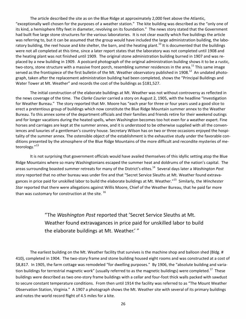
The article described the site as on the Blue Ridge at approximately 2,000 feet above the Atlantic, “exceptionally well chosen for the purposes of a weather station.” The kite building was described as the “only one of its kind, a hemisphere fifty feet in diameter, revolving on its foundation.” The news story stated that the Government had built five large stone structures for the various laboratories. It is not clear exactly which five buildings the article was referring to, but it can be assumed that the group would have included the large administration building, the labo‐ratory building, the reel house and kite shelter, the barn, and the heating plant.10 It is documented that the buildings were not all completed at this time, since a later report states that the laboratory was not completed until 1908 and the heating plant was not finished until 1909. The original stone administration building burned in 1907 and was re‐placed by a new building in 1909. A postcard photograph of the original administration building shows it to be a rustic, two‐story, stone structure with a massive front porch, resembling summer residences in the area.11 This same image served as the frontispiece of the first bulletin of the Mt. Weather observatory published in 1908.12 An undated photo‐graph, taken after the replacement administration building had been completed, shows the “Principal Buildings and Water Tower at Mt. Weather” and records the cost of the buildings as $181,527.
The initial construction of the elaborate buildings at Mt. Weather was not without controversy as reflected in the news coverage of the time. The Clarke Courier carried a story on August 2, 1905, with the headline “Investigation for Weather Bureau.” The story reported that Mr. Moore has “each year for three or four years used a good slice to erect a pretentious group of buildings which now constitute the Blue Ridge Mountain summer annex to the Weather Bureau. To this annex some of the department officials and their families and friends retire for their weekend outings and for longer vacations during the heated spells, when Washington becomes too hot even for a weather expert. Fine horses and carriages are kept at the summer annex, and it is understood to be otherwise supplied with all the conven‐iences and luxuries of a gentleman’s country house. Secretary Wilson has on two or three occasions enjoyed the hospi‐tality of the summer annex. The ostensible object of the establishment is the exhaustive study under the favorable con‐ditions presented by the atmosphere of the Blue Ridge Mountains of the more difficult and recondite mysteries of me‐teorology.”13
It is not surprising that government officials would have availed themselves of this idyllic setting atop the Blue
Ridge Mountains where so many Washingtonians escaped the summer heat and doldrums of the nation’s capital. The
areas surrounding boasted summer retreats for many of the District’s elites.14 Several days later a Washington Post
story reported that no other bureau was under fire and that “Secret Service Sleuths at Mt. Weather found extrava‐
gances in price paid for unskilled labor to build the elaborate buildings at Mt. Weather.”15 Similarly, the Winchester
Star reported that there were allegations against Willis Moore, Chief of the Weather Bureau, that he paid far more
than was customary for construction at the site. 16
“The Washington Post reported that ’Secret Service Sleuths at Mt.
Weather found extravagances in price paid for unskilled labor to build
the elaborate buildings at Mt. Weather.’ ”
The earliest building on the Mt. Weather facility that survives is the machine shop and balloon shed (Bldg. #
410), completed in 1904. The two‐story frame and stone building housed eight rooms and was constructed at a cost of
$8,817. In 1905, the farm cottage was remodeled “for dwelling purposes.” By 1906, the “absolute building and varia‐
tion buildings for terrestrial magnetic work” (usually referred to as the magnetic buildings) were completed.17 These
buildings were described as two one‐story frame buildings with a cellar and four‐foot thick walls packed with sawdust
to secure constant temperature conditions. From then until 1914 the facility was referred to as “The Mount Weather
Observation Station, Virginia.” A 1907 a photograph shows the Mt. Weather site with several of its primary buildings
and notes the world record flight of 4.5 miles for a kite.

27
Two magnetic buildings constructed in 1906 used in connection with “investigations in terrestrial magnetism”
The year 1907 saw the exoneration of Professor Moore after days of lengthy testimony before the House of
Representatives. The New York Times reported that Professor Moore was deemed to have acted properly in his au‐
thorization to build the facilities at Mt. Weather.18 Several days later, the Clarke Courier in great detail reported in a
story entitled “Harsh Criticism of Mt. Weather,” on the acrimonious hearings. The lengthy news story relied heavily on
the coverage of the House Committee on Expenditures of the Department of Agriculture chaired by Maine Representa‐
tive Littlefield. Mr. Littlefield contended that the expenditures were not justified, had been illegally diverted from
other expenditures, and had been based on erroneous testimony presented by Mr. Moore. “Responsibility for the in‐
ception of the Mount Weather project is placed squarely on Prof. Moore and the House Committee on Agriculture is
excused from blame…” according to Mr. Littlefield’s report. However, the majority of the committee did not concur,
and Mr. Mr. Littlefield’s report was submitted as a minority report, thereby exonerating Professor Moore.19
On October 23, 1907, the New York Times reported that a “bad fire” had destroyed the administrative building
at Mt. Weather. The loss was reported as $25,000 to the building where “important scientific experiments are in pro‐
gress,” and concluded that “fire [would] cripple that work.20 The Washington Post reported on October 26 that serious
injuries resulted from the fire, and several of the 16 residents in the building had to leap to safety.21 Two days later the
Clarke Courier reported that the losses were valued at between $25,000 and $30,000, with instruments and records
completely lost. The paper speculated that prompt reconstruction of the property would be ordered as soon as Con‐
gress reconvened.22
The Mt. Weather stables were built at a cost of $2,800 in 1908. The following year, a second residence, de‐
scribed as “a cottage for dwelling…a three‐story frame building [with] 15 rooms” at a cost of $1,738.69 was com‐
pleted.23 The sophisticated and imposing laboratory building was completed in 1909, as well as the reconstructed,
brick administration building. Both were designed by Frank H. Jackson of Washington, D.C. Jackson, a native of New
York, was an active architect in Washington between 1899 and 1918. His name appears on plans for both buildings.
He was a member of the Boston Society of Architects, (The Boston Chapter of the American Institute of Architects).
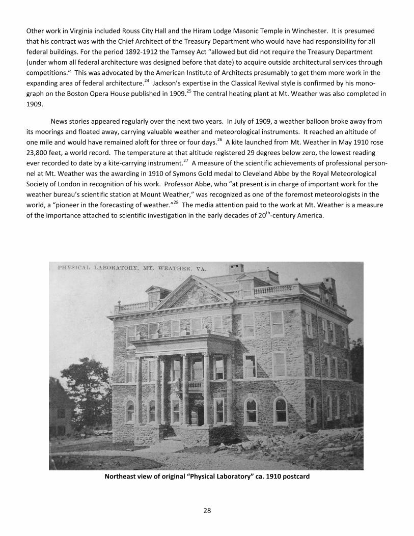
28
Other work in Virginia included Rouss City Hall and the Hiram Lodge Masonic Temple in Winchester. It is presumed
that his contract was with the Chief Architect of the Treasury Department who would have had responsibility for all
federal buildings. For the period 1892‐1912 the Tarnsey Act “allowed but did not require the Treasury Department
(under whom all federal architecture was designed before that date) to acquire outside architectural services through
competitions.” This was advocated by the American Institute of Architects presumably to get them more work in the
expanding area of federal architecture.24 Jackson’s expertise in the Classical Revival style is confirmed by his mono‐
graph on the Boston Opera House published in 1909.25 The central heating plant at Mt. Weather was also completed in
1909.
News stories appeared regularly over the next two years. In July of 1909, a weather balloon broke away from
its moorings and floated away, carrying valuable weather and meteorological instruments. It reached an altitude of
one mile and would have remained aloft for three or four days.26 A kite launched from Mt. Weather in May 1910 rose
23,800 feet, a world record. The temperature at that altitude registered 29 degrees below zero, the lowest reading
ever recorded to date by a kite‐carrying instrument.27 A measure of the scientific achievements of professional person‐
nel at Mt. Weather was the awarding in 1910 of Symons Gold medal to Cleveland Abbe by the Royal Meteorological
Society of London in recognition of his work. Professor Abbe, who “at present is in charge of important work for the
weather bureau’s scientific station at Mount Weather,” was recognized as one of the foremost meteorologists in the
world, a “pioneer in the forecasting of weather.”28 The media attention paid to the work at Mt. Weather is a measure
of the importance attached to scientific investigation in the early decades of 20th‐century America.
Northeast view of original “Physical Laboratory” ca. 1910 postcard

29
The presence of these two monumental government buildings – the Administration Building and the Physical
Laboratory building — on a remote mountain top in Virginia provides stunning confirmation of Professor Moore’s suc‐
cess in convincing the Congress and the Department of Agriculture of the significance of his work. It is ironic that within
less than four years of the completion of the two primary buildings, much of the work at Mt. Weather would become
obsolete. With the birth of the airplane and the capacity to measure and record weather conditions at greater alti‐
tudes, the need for Mt. Weather for launching balloons and kites and maintaining laboratories and administrative
buildings was greatly diminished. Weather research and recording functions were transferred to Omaha, Nebraska.
1927 East view of Administration and Observatory Building
The first public record of the search for a new use for the buildings at Mt. Weather appeared in May of 1914.
In a story entitled “Bill Offered to Create Summer White House in Virginia,” the Washington Post reported that Repre‐
sentative Charles C. Carlin of Virginia introduced a bill to establish a summer residence for the President at Mt.
Weather. It would not be the last time that such a suggestion was proposed. Carlin said that the “bureau [U. S.
Weather Bureau] buildings in Shenandoah and Loudoun valleys are admirably suited for the Residences. The President
and his family could enjoy complete privacy.” He declared that the area enjoyed great climate advantages along with
ready accessibility, coupled with privacy for the first family. He contended that both telegraph and telephone lines al‐
ready ran into the grounds.
Carlin referred to a bill already introduced to abandon Mt. Weather as “a station of the Weather Bureau.” One
building, he said, would be suited for offices, and the other could be converted into a “commodious residence.”29
Three weeks later, Virginia Senator Swanson offered a bill to do the same thing. There is no evidence that either bill
made any headway in either the House or the Senate. The only discrepancy reported in the news story was that the
acreage at Mt. Weather was “84 acres.” The total acreage deeded to the government in 1902 and 1903 totaled about
108 acres according to deeds in Loudoun and Clarke Counties. However, in the report from Secretary of Agriculture D.
F. Houston in 1914, it is stated that a total of 84.81 acres were acquired in two parcels, one of 67.25 acres and one of
17.56 acres. There do not seem to be any deeds recorded in which the government sold 24 acres of its holdings ac‐
quired in 1902‐1903, and the discrepancy may in fact be attributed to a mistake in the original plat.

30
The 1914 Report presented by the Secretary of Agriculture to the Speaker of the House of Representatives pro‐
vides a very detailed description of Mt. Weather and its historic grounds and buildings. The report describes the prop‐
erty including its location and relationship to rail lines and the city of Washington. It delineates all the buildings that
were then standing along with their building dates, condition, and value. The report points out that the entire tract
was “well enclosed, partly by a stone‐wall fence and wire fencing.” By the date of this report, December 14, 1914, the
weather investigations that had taken place at Mt. Weather had been transferred to Omaha, Nebraska. The report
indicated that the primary obstacle to the continued use of Mt. Weather by the Department of Agriculture “is the pre‐
sent poor condition of the road from Bluemont (the nearest rail terminus). Apparently weather observations were still
being conducted at Mount Weather; the care of all buildings and grounds was estimated to be $2,000 annually. The
buildings and grounds were deemed appropriate for a summer hotel or country club, a sanitarium, or a school, all pur‐
poses that were proposed in succeeding years. The report observed that the location “is such as neither the buildings
nor grounds could be leased.”30
Bldg. # 413, with 1909 cottage dwelling in background.
Aside from the comprehensive report on the conditions, buildings, and costs included in the 1914 report, there
was little consideration of the future for Mt. Weather for the next five years. A memorandum from the Secretary of
Agriculture dated November 10, 1920, states: “During the period of the war every effort was made to find some legiti‐
mate Government use to which this institution could be placed. It was examined by a number of Government repre‐
sentatives tentatively interested therein, but the uniform result was that the site was considered unacceptable for any
practical purposes.”31 The 1920 memorandum states that seven years earlier in 1913 it had become fully apparent that
the “weather observing” station’s maintenance was unduly expensive because of its “comparative inaccessibility and
isolation.” The memorandum acknowledged the importance of the weather observations and research conducted at
Mt. Weather for the short period between 1903 and 1914, but justifies the discontinuance of the Mt. Weather activi‐
ties. Again, the report extols the “delightful character of the climate and atmospheric conditions” and suggests that it
is “peculiarly fit (as the) location for a summer resort for tourists, boarders or the like.” The recommendation was that
the property be sold.32
31
The next report relating to the disposition of Mt. Weather was filed in November 1926. For the most part, this
memorandum reiterates information from the two earlier comprehensive reports.
A number of proposals had been offered for use of Mt. Weather during the decade after 1914. Its salubrious
climate and isolated location made it particularly appropriate for a number of functions not directly related to govern‐
ment functions. A news article in the Washington Post in February, 1914, announced that “Congress will shortly offer
this fine estate for sale,” since it “has ceased to be useful” as a weather station.33 Another Washington Post article in
May of the same year reported that Representative Carlin from Virginia had offered a bill to make Mt. Weather a sum‐
mer White House.
But it was not until the decade of the 1920s that serious consideration was given to converting the property for
use by the U. S. President. President Coolidge asked Congress to appropriate $48,000 to repair Mt. Weather. Photo‐
graphs of the two primary buildings on the property – the original laboratory and the rebuilt administration building
accompanied the news article. Coolidge proposed that the property be transferred from the Department of Agricul‐
ture to Lt. Col. U. S. Grant III, director of the public buildings and public parks. Coolidge had earlier suggested that
there was a need for a summer residence for the president in an article published in the St. Louis Post Dispatch, which
led to a number of states offering sites for the summer getaway for the chief executive.34 It is interesting to note that
Washington Post article reports that the size of the Mt. Weather tract was 184 acres.
The New York Times reported the story as well, but provided somewhat more detail.35 It states, for example,
that President‐elect Hoover also approved the request for the appropriation, a curious endorsement given that Hoover
later objected to Mt. Weather’s selection as a location for a summer White House. Articles published in the New York
Times on March 15 and 17, after Hoover’s inauguration, reported that Hoover opposed acquiring Mt. Weather for such
a use and spending $25,000 on the refurbishment of the buildings for residential use. Hoover said that “the place is
hot and offers nothing but scenery.” He preferred to go deep‐sea fishing, using the presidential yacht Mayflower. He
wanted a place that offered good fishing and seclusion, and Mt. Weather, although enjoying a high level of seclusion,
provided few opportunities for fishing.36 Ironically, in anticipation of locating the summer White House at Mt.
Weather, the Commonwealth of Virginia appropriated $102,000 for widening and improving roadways between Wash‐
ington and Mt. Weather.37
“Herbert Hoover said that ‘the place is hot
and offers nothing but scenery.’ ”
A letter from the Secretary of Agriculture to the House Agriculture Committee in December of 1923 reiterates
the claim that the Mt. Weather property was too expensive for the government to maintain and that the nearest rail
transportation was nearly seven miles away. An insertion was made to the Agriculture Appropriations Bill for that year
directing that the property be sold to the highest bidder. A letter in the Agriculture department records from a Wash‐
ington attorney dated November 24, 1923, expressed interest in acquiring the property, presumably for an unnamed
client, but no sale resulted. In 1924, the local paper reported that Mt. Weather would not be used as a prison facility, a
proposal that was included in a bill offered in the House of Representatives.38 The bill had called for the use of the
property for a woman’s penal institution or a reformatory. Arguing before the House Judiciary Committee, the assis‐
tant attorney general, Mabel Walker Wellebrandt, strenuously opposed such a move, which effectively killed the pro‐
posal.39
32
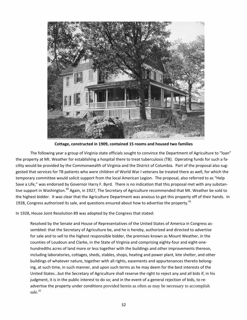
Cottage, constructed in 1909, contained 15 rooms and housed two families
The following year a group of Virginia state officials sought to convince the Department of Agriculture to “loan”
the property at Mt. Weather for establishing a hospital there to treat tuberculosis (TB). Operating funds for such a fa‐
cility would be provided by the Commonwealth of Virginia and the District of Columbia. Part of the proposal also sug‐
gested that services for TB patients who were children of World War I veterans be treated there as well, for which the
temporary committee would solicit support from the local American Legion. The proposal, also referred to as “Help
Save a Life,” was endorsed by Governor Harry F. Byrd. There is no indication that this proposal met with any substan‐
tive support in Washington.40 Again, in 1927, The Secretary of Agriculture recommended that Mt. Weather be sold to
the highest bidder. It was clear that the Agriculture Department was anxious to get this property off of their hands. In
1928, Congress authorized its sale, and questions ensured about how to advertise the property.41
In 1928, House Joint Resolution 89 was adopted by the Congress that stated:
Resolved by the Senate and House of Representatives of the United States of America in Congress as‐
sembled: that the Secretary of Agriculture be, and he is hereby, authorized and directed to advertise
for sale and to sell to the highest responsible bidder, the premises known as Mount Weather, in the
counties of Loudoun and Clarke, in the State of Virginia and comprising eighty‐four and eight‐one‐
hundredths acres of land more or less together with the buildings and other improvements thereon,
including laboratories, cottages, sheds, stables, shops, heating and power plant, kite shelter, and other
buildings of whatever nature, together with all rights, easements and appurtenances thereto belong‐
ing, at such time, in such manner, and upon such terms as he may deem for the best interests of the
United States…but the Secretary of Agriculture shall reserve the right to reject any and all bids if, in his
judgment, it is in the public interest to do so; and in the event of a general rejection of bids, to re‐
advertise the property under conditions provided herein as often as may be necessary to accomplish
sale.42
33
There do not appear to have been any satisfactory bids submitted over the next four years, and a memoran‐
dum in the Department of Agriculture files at the National Archives for the year 1932 stated unequivocally that the Mt.
Weather property was no longer available for sale. However, there were still efforts to find a use for the property when
the Washington Post reported that the Loudoun County Post of the American Legion adopted a resolution in 1931 urg‐
ing the use of Mt. Weather as a site for a U. S. Veterans Hospital. There is no indication that the proposal was seriously
considered.43
On December 5, 1933, early in the Roosevelt administration, a permit was issued by Secretary of Agriculture
Henry A. Wallace to the Federal Emergency Relief Administration. On December 13, 1933, the Washington Post re‐
ported that “Mount Weather will be used as Work Camp.” The story indicates that “85 acres of land” with buildings
would be turned over to the relief agency by the Agriculture Department. President Roosevelt’s plans called for em‐
ployment by the federal government of many who had lost jobs during the Great Depression. The property was re‐
ferred to as a “transient camp,” indicating that no alternative large scale operations were contemplated. The newspa‐
per article states that the property had been occupied only by a caretaker for many years.44 It can be presumed that
the caretaker likely lived in one of the two residential buildings on the property: either the farm cottage that the
Weather Bureau had restored in 1905 or the larger 1909 frame dwelling.
The search for a practical use for the Mt. Weather property continued. In 1934, a request came to the Agricul‐
ture Department from the Poet League, Incorporated, to use the mountain top property for a retreat for poets. There
is no indication that proposal was ever considered. Another proposal called for Mt. Weather to serve as a tuberculosis
hospital for the District of Columbia, echoing a similar suggestion from the state of Virginia a decade earlier. Some lo‐
cal records indicate that WPA and CCC workers may have occupied the buildings at Mt. Weather on a temporary basis
during the mid‐1930s, perhaps while they were employed in various federal projects in the area. There is some indica‐
tion that the property was farmed by so‐called “hobos”, but it is unlikely that much farming was conducted since there
was so little arable land appropriate for agriculture on the property.
“In 1934, a request came to the Agriculture Department from the
Poet League, Incorporated, to use the mountain top property for a re‐
treat for poets. Another proposal called for Mt. Weather to serve as a
tuberculosis hospital for the District of Columbia.”
In 1936, the Department of Agriculture was finally able to find a practical governmental use for Mt. Weather.
In that year, under a cooperative arrangement between the Weather Bureau and the Department of Agriculture, pri‐
mary responsibility for the buildings and land was transferred to the U. S. Bureau of Mines, which had only two years
earlier been returned to the Department of the Interior.45 On November 19, 1936, the chief of the Bureau of Mines, W.
R. Gregg, requested permission to conduct research on fundamental mining practices and problems. He specified that
the mine would be located near the south fence of the grounds as least 1,500 feet from other buildings on the prop‐
erty. Mr. Gregg stated that the mine would be a maximum of 20 feet deep and that care would be taken to keep an
adequate distance from the Mt. Weather reservation pumping station. He also indicated that members of a CCC camp
at Front Royal, Virginia would help clear the roads to facilitate better access to the property. He stated that the “farm
house” would be improved for use by the Engineer in Charge, Mr. [Wing] Agnew. Permission was granted by Secretary
of Agriculture, Henry A. Wallace.46
The local press provides the best description of what went on at Mt. Weather during this period. In a news
article of April 1, 1937, entitled “Research Tunnel at Mt. Weather: United States Bureau of Mines conducting Experi‐
ments in Drilling and Blasting,” it was reported that a “research tunnel, or adit, has been established by the United

34
States Bureau of Mines…at Mt. Weather.” The article goes on to say: “The site was selected as being the most desir‐
able among many considered because it is on government‐owned land and because the prevailing rock is especially
suitable for conducting drilling tests.”47
The experimental tunnel was constructed under the direct supervision of Wing G. Agnew, who became a long‐
time employee of Mt. Weather. “The object of the research at Mt. Weather is to increase the knowledge of the details
of the various steps in metal mining and to improve the underground working conditions affecting the health of min‐
ers,” the story reports. Beyond that, drilling was used to test the relative efficiency of various types of drills. Different
blasting methods and techniques were tried that would provide adequate ventilation to underground mines. The news
article also relates that members of the nearby CCC camp at Front Royal assisted in clearing the grounds and upgrading
the roadways for the test mining operations at Mt. Weather. After 25 years of essentially lying fallow, Mt. Weather
was finally being used for highly practical purposes. A vivid photograph taken in 1939 shows the striking mine opening
and carries the following revealing captive:
When work first started on this mountain tunnel three years ago, native mountaineers had visions that
workers were digging for gold. But such is not the case. Under the direction of Wing G. Agnew, the
Bureau of Mines is conducting tests under mining conditions of explosives, rock formations, and other
mining conditions. The adit is located on the government‐owned property at Mt. Weather. The above
picture shows a general view of the entrance, track and cars. Four workers are laboring over 600 feet
back in the tunnel…48
According to the story, the miners were recruited from neighboring farms, and although they had no experi‐
ence, “they have developed into satisfactory miners.” Apparently, the Bureau of Mines investigated several other sites
in the eastern U. S., but found that the quality of the rock at Mt. Weather was particularly well suited for testing both
mining equipment and mining conditions.
The only other use for Mt. Weather and its buildings in the 1930s was as a site for meetings of the Soil Conser‐
vation Service. The announcement for a meeting in June 1937 included maps of the area. Various “bureau chiefs” of
the Conservation Service gathered in that year. It is likely that the Mt. Weather facility may have been used for other
government retreats or conferences, but it is not reflected in any of the official records of the time.
During the period of World War II, from 1942 to 1947, Mt. Weather was the site of a Civilian Public Service
(CPS) Camp, operated by the Brethren Service Committee. Public Service camps provided conscientious objectors an
alternative to service during the War. “Nearly 12,000 draftees, willing to serve their country in some capacity but un‐
willing to do any type of military service, performed work of national importance in 152 CPS camps throughout the U.
S.” Those who participated were supported by various churches and the Brethrens were among the various “peace
churches” that chose to participate.
Led by the American Friends Service Committee (Quakers), the Selective Service Act of 1940 included a section
stating that “Any such person claiming such exemption from combatant training and service can in lieu of such induc‐
tion, be assigned to work of national importance under civilian direction.”49 Although there is no specific record, a
World War II‐era photograph shows some of the participants recording weather conditions at Mt. Weather as part of
their service. It is also possible that some work was conducted for the Soil Conservation Service. The only newspaper
coverage of the conscientious objectors housed at Mt. Weather appeared in the Washington Post in 1945 reporting on
the indictment by a federal grand jury of Robert Evans Poole, charged with “deserting a Civilian Public Service Camp at
Mt. Weather, Bluemont, in Loudoun County, VA on June 6, 1945, where he was serving as a conscientious objector.”
Apparently Poole had served at several other camps in Georgia, North Carolina, and Tennessee, before being trans‐
ferred to Virginia. 50

35
There is no record of any new structures built on the property between the completion of the original Weather
Bureau complex in 1910 and 1954. Beginning in 1955 and continuing in 1956, the Federal Government obtained
through “Declarations of Taking” additional land totaling about 533 acres in Clarke and Loudoun counties. These tak‐
ings, filed in the Federal District court in Lynchburg, Virginia, were signed by the then‐Secretary of the Army, Robert T.
Stevens. All landowners were compensated for their property. Among the landowners were families who names were
well‐known in Clarke and Loudoun, including Kenneth N. Gilpin, Earl W. Wiley, and J. E. Fowler.51
During this decade of the 1950s and 1960s, there were a number of federal agencies whose responsibilities
included Mount Weather. The massive construction campaign that took place in the late 1950s was carried out by the
Army Corps of Engineers and it appears that Mount Weather remained in the Department of Defense for most of the
period. Various predecessor federal agencies with jurisdictions included the Federal Civil Defense Administration, the
Office for Emergency Management, the Executive Office of the President (1950‐58), the Office of Defense and Civilian
Mobilization (1958), the Office of Civil and Defense Mobilization (1958‐61), the Office of Civil Defense (1961‐64), and
the Department of the Army (1964‐72). The current agency operating the site is FEMA, part of the Department of
Homeland Security.52
The largest number of buildings constructed at Mt. Weather was during the 1950s. The majority of the new
structures, all designed and constructed by the Army Corps of Engineers, were dormitories that resembled barracks in
their size and configuration. These buildings, all of which were constructed in 1958, were primarily used to house civil
defense workers who traveled to Mt. Weather for training. Government personnel from various emergency response
agencies came to Mt. Weather to be trained. Residential facilities were required for all training instructors as well.
Civilian and military personnel receiving training in how to respond to both natural disasters, like hurricanes and fires,
and later disasters related to terrorism and other threats to national security. A number of buildings functioning as
support structures for personnel and operations were built at Mt. Weather such during the closing years of the decade
of the 1950s including a sewage treatment plant (1957); a water treatment plant (1958); a café/dining facility (1958); a
motor pool building (1958); a health unit (1958) and a fire department (1958). More than a dozen buildings used as
offices or as combination office and residential units were also constructed in 1958‐59. Warehouses and maintenance
shops make up the balance of the buildings from this period.53
Construction continued at Mt. Weather during the decades after the massive building campaign of the late
1950s. During the 1960s and 1970s several warehouse and office buildings (1960, 1971, 1976), a storage facility
(1970); a training building (1977) and a control tower (1970) were constructed. Only three existing buildings date to
the 1980s: an office/storage building (1984); and two warehouses (1986, 1989). Additional office training buildings
were erected in 1990 and 1999; and an office/warehouse and two storage buildings, one described as a “salt/stone
storage building” and the other as a “pole” building in 1992 and 1998. Mt. Weather’s importance as a critical commu‐
nications center is attested by the construction of two new office/data centers in 2004 and 2009, with several ancillary
support buildings constructed in 2000, 2005, and 2006. A Visitor’s Center was built in 2004. None of these buildings
that contribute functionally to the facility is historic, but continue to fulfill the requirements for the facility.
Mt. Weather is a rare historic government facility whose functions have varied greatly over the 100 years since
its beginnings as a weather station. All of its historic structures that retain architectural integrity pre‐date 1909. Gov‐
ernment officials and politicians tried to find a permanent use for the remote site for nearly 50 years.
Today, Mt. Weather provides FEMA and other government agencies space for offices, operations, and storage,
and is a hub of our Nation’s emergency response activity. Its mission is to manage, operate, and maintain the Mt.
Weather Emergency Operations Center to support Department of Homeland Security (DHS) and other Federal Depart‐
ments' and Agencies' emergency management programs at all times and under all conditions.54

36
Mount Weather Timeline
History Year Construction Event
U.S. Weather Bureau established by Act of Congress (within the U.S. Department of Agriculture). 1890
Money appropriated to the Weather Bureau to purchase land and construct necessary buildings ($50,000). 1902‐1903
Purchase of land from private property owners Herbert F. L. Allen and George W. Kelley in Loudoun County. 1902‐1903
Acreage acquired included a farmhouse, springhouse, and stable.
First buildings constructed for the Weather Bureau facility at Mt. Weather. 1904
Stone administration building, machine shop, balloon shed, and gas storage units constructed.
1904 Route 601 completed from Paris, Virginia, to Mt. Weather.
1905 Existing farm cottage remodeled.
1906 Magnetic buildings completed.
1907 Fire destroys stone administra‐tion building.
1908 Laboratory, reel house, stables, and kite shelter completed.
1909
Stone Physical Laboratory, stone heating plant, frame dwelling, and brick Administration building constructed.
1914
No longer used as a weather sta‐tion; Secretary of Agriculture presents comprehensive report to Congress delineating construc‐tion history at Mt. Weather.

37
History Year Construction Event
Rep. Charles C. Carlin (VA) and Senator Swanson (VA) offer bills to use aban‐doned buildings at Mt. Weather for a summer “White House.” 1914
No construction at Mt. Weather between 1910 and 1936.
Weather Bureau Chief C. W. Marvin states that Mt. Weather inappropriate for use as a home for disabled soldiers in a letter dated Nov. 12, 1920. 1920
U. S. House of Representatives Resolu‐tion to auction Mt. Weather. 1921
Report for the Weather Bureau: two caretakers; annual maintenance cost $2,000. 1922
Buildings unused for eight years (1914‐1922).
House Bill 2869 calls for establishment of U. S. Reformatory for Males at Mt. Weather.
1923
Appropriations bill for Agriculture De‐partment calls for sale of Mt. Weather to highest bidder. 1923
House Resolution calls for establish‐ment of a women’s industrial farm at Mt. Weather. 1924
Proposal reported in local newspaper that Mt. Weather become a state tuber‐culosis hospital. 1925
Recommended by the Secretary of Agri‐culture that Mt. Weather be sold to highest bidder. 1927
President Coolidge requests $48,000 to establish a summer White House at Mt. Weather. Denied by Congress. 1928
Mount Weather Timeline, continued
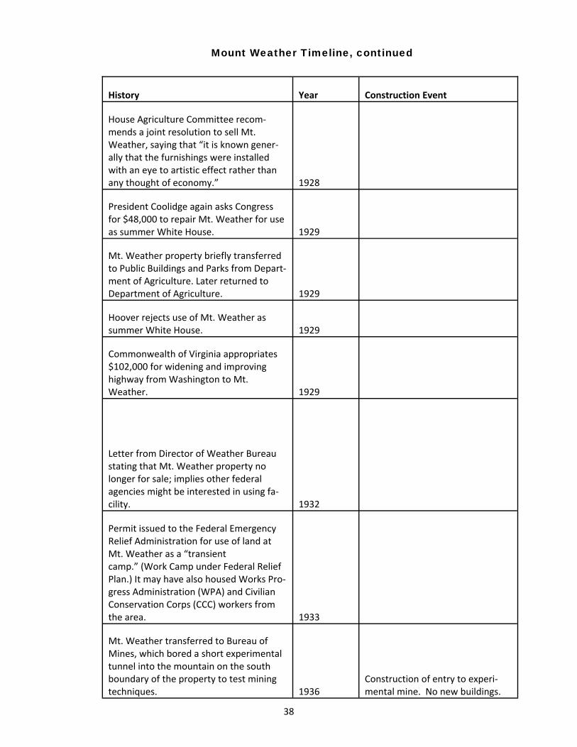
38
House Agriculture Committee recom‐mends a joint resolution to sell Mt. Weather, saying that “it is known gener‐ally that the furnishings were installed with an eye to artistic effect rather than any thought of economy.” 1928
President Coolidge again asks Congress for $48,000 to repair Mt. Weather for use as summer White House. 1929
Mt. Weather property briefly transferred to Public Buildings and Parks from Depart‐ment of Agriculture. Later returned to Department of Agriculture. 1929
Hoover rejects use of Mt. Weather as summer White House. 1929
Commonwealth of Virginia appropriates $102,000 for widening and improving highway from Washington to Mt. Weather. 1929
Letter from Director of Weather Bureau stating that Mt. Weather property no longer for sale; implies other federal agencies might be interested in using fa‐cility.
1932
Permit issued to the Federal Emergency Relief Administration for use of land at Mt. Weather as a “transient camp.” (Work Camp under Federal Relief Plan.) It may have also housed Works Pro‐gress Administration (WPA) and Civilian Conservation Corps (CCC) workers from the area. 1933
Mt. Weather transferred to Bureau of Mines, which bored a short experimental tunnel into the mountain on the south boundary of the property to test mining techniques. 1936
Construction of entry to experi‐mental mine. No new buildings.
History Year Construction Event
Mount Weather Timeline, continued
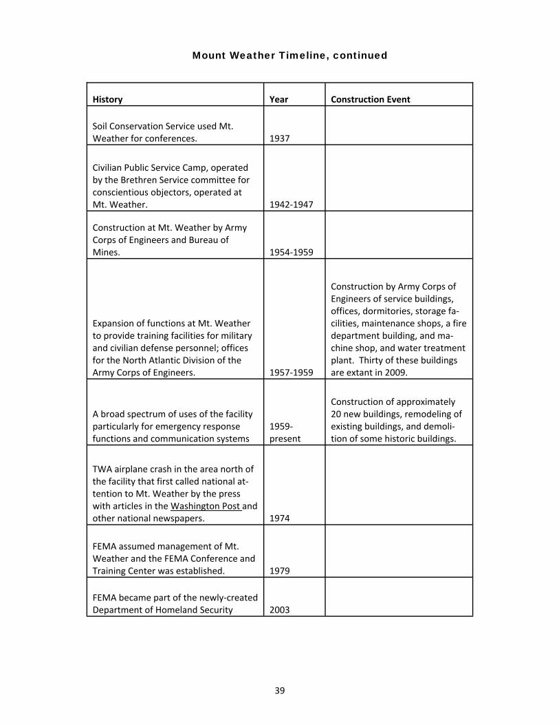
39
Soil Conservation Service used Mt. Weather for conferences. 1937
Civilian Public Service Camp, operated by the Brethren Service committee for conscientious objectors, operated at Mt. Weather. 1942‐1947
Construction at Mt. Weather by Army Corps of Engineers and Bureau of Mines. 1954‐1959
Expansion of functions at Mt. Weather to provide training facilities for military and civilian defense personnel; offices for the North Atlantic Division of the Army Corps of Engineers. 1957‐1959
Construction by Army Corps of Engineers of service buildings, offices, dormitories, storage fa‐cilities, maintenance shops, a fire department building, and ma‐chine shop, and water treatment plant. Thirty of these buildings are extant in 2009.
A broad spectrum of uses of the facility particularly for emergency response functions and communication systems
1959‐present
Construction of approximately 20 new buildings, remodeling of existing buildings, and demoli‐tion of some historic buildings.
TWA airplane crash in the area north of the facility that first called national at‐tention to Mt. Weather by the press with articles in the Washington Post and other national newspapers. 1974
FEMA assumed management of Mt. Weather and the FEMA Conference and Training Center was established. 1979
FEMA became part of the newly‐created Department of Homeland Security 2003
History Year Construction Event
Mount Weather Timeline, continued

40
Endnotes 1 Bulletin of he Mount Weather Observatory. Volume I. [Washington: U. S. Weather Bureau, 1908]. Prepared under the direction of
Willis L. Moore, Chief, U. S. Weather Bureau. 2 Cited in a Memorandum for the Secretary in re: Legal status of the Mount Weather Station of the Weather Bureau. November 29,
1933. 3 A deed for the core acreage that comprises Mount Weather was recorded in Loudoun County in 1888 from the Special Commis‐
sioner G. B. Gibson to Robert N. Kelly for 96 acres for which Mr. Kelly paid $600. The deed was made under the authority of a de‐
cree of the Circuit Court for the County that had been handed down in August of 1885. The property was described as being lo‐
cated near the community of Trapp and being adjacent to the lands of John T. Ross and described as being the same parcel that
Jeremiah Trapnell owned when he died. The property had been the subject of a Chancery suit filed in the county in 1885. In 1900,
Robert Kelley [sic] and his wife Labelia deeded this same 96‐acre parcel to Herbert F. L. Allen who was a resident of Washington, D.
C. The selling price was listed as $1,000. The property was again described as adjacent to the lands of the late John T. Ross. A plat
prepared by George T. Norris is referenced but not attached to the deed. It can be presumed that the detailed plat is the same as
appears in the subsequent deed from Allen to the U. S. Government in 1902. Loudoun County Deed Book 7A, page 61 (1888); Lou‐
doun county Deed Book 7T, page 59 (1900). 4 Loudoun County Deed Book 7Y, pages 74‐76 (1902). 5 Report by the Secretary of Agriculture D. F. Houston to the Speaker of the House of Representatives pursuant to the instructions
contained in the act of Congress dated June 24, 1914 (Public Law No. 122, 63rd Congress, HR 13679 entitled “An act making appro‐
priations for the Department of Agriculture for the fiscal year ending June 30, 1915.” Records Group 16, Records of the Secretary of
Agriculture General Correspondence Box 1070, Stack Area 170. National Archives, College Park, Maryland. 6 Loudoun County Deed Book 7Y, pages 78‐81 (1903). 7 Clarke County Deed Book 2, page 100‐102, (1903). 8 Clarke County Deed Book Y, page 416 (1896). 9 Report by the Secretary of Agriculture (1914)…; Clarke Courier, July 13, 1904. 10 The New York Times, July 8, 1905. 11“Bear’s Den Rural Historic District,” National Register Nomination, 2008. 12 Bulletin of the Mount Weather Observatory. Volume I. [Washington: U. S. Weather Bureau, 1908]. Prepared under the direction
of Willis L. Moore, Chief, U. S. Weather Bureau. 13 Clarke Courier, August 2, 1905. 14 See the National Register nomination for the “Bear’s Den Historic District,” 2008. 15 Washington Post, August 8, 1905. 16 Winchester Star, August 11, 1905. 17 Report by the Secretary of Agriculture (1914) 18 New York Times, March 3, 1907. 19 Clarke Courier, March 6, 1907, quoting from a news article in the Washington Post. 20 New York Times, October 2, 1907. 21 “Their Injuries Serious,” Washington Post, October 26, 1907. 22 Clarke Courier, October 30, 1907. 23 Report by the Secretary of Agriculture…June 24, 1914. 24 Craig, Lois A. and the staff of the Federal Architecture Project. The Federal Presence: Architecture, politics, and symbols in United
States Government Building. [Cambridge, MA: MIT Press, 1978]. 149. 25 American Federation of Arts. American Arts Directory [Ann Arbor, Michigan: R. R. Bowker, Company, 1900, 1914], 137; Frank H.
Jackson. Monograph of the Boston Opera House. [Boston: W.A. Butterfield, 1909]. 26 Washington Post, July 23, 1909. 27The New York Times, May 6, 1910. 28 Washington Post, November 18, 1911, 3.

41
29 Washington Post, May 7, 1914. 30 Report by the Secretary of Agriculture, 1914…, p. 3. 31 “Memorandum for the Secretary (of Agriculture) Concerning the Disposal of Mount Weather.” November 10, 1920. 32 Ibid. 5. 33 Washington Post, February 5, 1914. 34 Washington Post, February 14, 1929. 35 New York Times, February 14, 1929. 36 New York Times, March 15 and March 17, 1929. 37 Clarke Courier, June 6, 1929. “$102,000 Granted for Mt. Weather Highway.” 38 House Bill 3266 (1924). 39 Clarke Courier, January 24, 1924. “Mt. Weather Site for Prison Facility Unlikely.” 40 Clarke Courier, December 17, 1925. “Propose Mt. Weather for TB Hospital: “Help Save A Life” Slogan of Committee Seeking Con‐
version of Former Observation Station into Sanitarium for Treatment of Incipient Cases.” 41 All citations for this period are included in loose papers and correspondence in the official records for the Department of Agricul‐
ture housed at the National Archives, College Park, Maryland. 42“Hearings Before the Committee on Agriculture House of Representatives. Seventieth Congress (First Session)” February 2, 1928.
[Washington: Government Printing Office, 1928], 16‐18. 43 Washington Post, August 12, 1931. 44 Records of the Department of Agriculture for 1933 in the National Archives, College Park, Maryland; Washington Post, December
13, 1933. 45 Records Group 70, Records of the U. S. Bureau of Mines. “Administrative History (70.1).” [NARA Mid‐ Atlantic Region, Philadel‐
phia, PA]. 46 Official Records and correspondence for the U. S. Department of Agriculture, Records Group 16. [National Archives, College Park,
MD], 1936. 47 Clarke Courier, April 1, 1937. 48 Clarke Courier, “Testing Adit on Mountain Reaches 600 Feet Underground as Work Continues,” May 4, 1939. 49 Cornelius Krahn et. Al The Mennonite Encyclopedia, Volume I. [Scottsburg, PA: Mennonite Publishing Company], 604; Civilian
Public Service Camp Publication Database [http://130.58.64.153/fmi/xsl/SCPC_CPS…] 50 Washington Post, October 4, 1945, 14. 51 Loudoun and Clarke County Deed books (1955, 1956). 52 Records of the Defense Civil Preparedness Agency. http://www.archives.gov/research/guide‐fed‐records/groups/397.html. 53 See also Office of Civil and Defense Mobilization, Records Group 304. College Park, MD: National Archives. The administrative
history records that this agency “administered the national civil defense program; coordinated military, industrial, and civilian mo‐
bilization. Civil defense functions transferred to the Office of the Secretary of Defense by Executive Order 10952, July 20, 1961.”
Successor agencies were the Office of Civil Defense (1961‐72) in the Department of Defense, and on July 20, 1979, under Executive
Order 12148 became the Federal Emergency Management Agency (FEMA). See Records Group 397, “Records of the Defense Civil
Preparedness Agency.” This agency “coordinated and directed federal, state and local civil defense program activities, including
fallout shelters; chemical, biological, and radiological warfare defense; emergency communications and warning systems; post‐
attack assistance and damage assessment, preparedness planning, and government continuity. FEMA is now part of the Depart‐
ment of Homeland Security as of 2003. For earlier history of these government functions, see also Executive Order 10222,
“Providing for certain transfers to the Federal Civil Defense Administration,” March 8, 1951. (www.archives.gov/federal‐register/
codification/executive‐order/10222.html/) 54www.fema.gov
42
Bibliography
Books/Articles: American Friends Service Committee. Civilian Public Service. Testimony by Workers; A report of the Friends Civilian
Public Service. [Philadelphia PA: Civilian Public Service of the American Friends Service Committee, 1942].
Craig, Lois and the staff of the Federal Architecture Project. Architecture, Politics and Symbols in United States Govern‐
ment Building. [Cambridge, MA: MIT Press, 1978].
“Establishment of a United States Industrial Home for Women at Mt. Weather, Va.” Hearings, Sixty‐Seventh Congress,
fourth session, on sb. 4452, a bill for the establishment… [Washington, D. C.: government Printing Office,
1923].
“Inside Loudoun: The Way It Was.” (News in the 1930s.) Leesburg: Thomas Balch Memorial Library. Examined April,
2009.
Keim, Albert N. The CPS Story: an illustrated History of Civilian Public Service. [Intercourse, PA: Good books, 1990].
United States Congress (House), Committee on Agriculture. “Mt. Weather Property Disposal.” Hearings before the
Committee on Agriculture, House of Representatives, Seventieth Congress, first session, on H.R. 7942. H.J. Res.
89, February 2, 1928. [Washington, DC: U. S. Government Printing Office, 1928].
U. S. Department of Agriculture. Bulletin of the Mt. Weather Observatory. 6 vols. [Washington, DC: U. S. Department
of Agriculture, 1908‐1914].
Web Sites visited: Civilian Public Service Camp Publications Database: Swarthmore College Peace Collection. http://130.58.64.153..
(Visited 6/10/2009).
Federal Emergency Management Agency. Mt. Weather Emergency Assistance Center Home Page. http://
www.fema.gov/pte/weather.htm.
“Mt. Weather Emergency Operations Center (MWEOC)” FEMA Fact Sheet.
U. S. Army Corp of Engineers. “Who We Are.” http://www.tac.usace.army.mil/Organization/tac_overview.html.
(Visited June 29, 2009).
Electronic communication from Michael J. Brodhead, PhD. Historian, Office of History. U. S. Army Corps of Engineers.
Alexandria, Va. June 10, 2009. See also [email protected].
Pictures and Other Images: “Mt. Weather.” (Loudoun Co, Va. U. S. Weather Bureau, wall and entrance gate). Virginia State Chamber of Commerce
Collection. [Richmond, VA: Library of Virginia. c. 1922].
“Coolidge’s Choice for Summer White House.” Mt. Weather (1928). [Washington, DC: Library of Congress, Prints and
Photographs, Digital ID cph3c37488].

43
Records of the United States Weather Bureau. Records Group 27. Box 8 [College Park, MD: National Archives]. This
collection includes the building plans for the Laboratory and the Administration building by Frank H. Jackson
dated 1908. Also included in this record group is a bound book entitled: Mt. Weather Station of the Weather
Bureau, U.S. Department of Agriculture. January 1, 1928. It was prepared by William R. Thickstun under the
supervision of Charles C. Clarke, Assistant Chief, and the photographs in the publication were taken by Frank M.
Blake in 1927. Also included is a keyed site map locating the individual buildings and a brief description of each
of them.
Newspapers: Clarke Courier. July 13, 1904; August 2, 1905; March 6, 1907; October 30, 1907; January 24, 1924; December 17, 1925;
June 6, 1929; April 1, 1937; May 4, 1939.
New York Times. July 8, 1905; March 3, 1907; October 24, 1907; July 23, 1909; May 6, 1910; February 14, 1929; March
15, 1929; March 17, 1929; March 27, 1937; December 2, 1974.
Washington Post. August 8, 1905; October 26, 1907; July 23, 1909; November 18, 1911; February 5, 1914; May 7, 1914;
February 25, 1928; May 4, 1928; May 27, 1914; February 14, 1929; August 12, 1931; April 12, 1933; December
13, 1933; October 4, 1945; December 2, 1974; May 26, 1984.
Winchester Star. August 10, 2005.
Deeds in Loudoun and Clarke Counties: Clarke County Deed Books Y (1896); 2 (1903); 6(1910); 17(1927); 49(1955);
Loudoun County Deed Books 7A (1888); 7F (1903); 7T (1900); 7Y (1902, 1903); 350(1955); 354 (1956); 358 (1956); 359
(1956)
Loudoun County Will Book 4B (1948).
Other Sources: “An Act Making Appropriations for the Department of Agriculture for the Fiscal Year Ending June 30, 1903, approved
June 3, 1902. (also Appropriation Act for 1904).
Weather Bureau. For the purchase of sites and erection of not less than six buildings for use as Weather Bu‐
reau observatories, and for all necessary labor, materials, and expenses; plans and specifications to be pre‐
pared and approved by the Secretary of Agriculture, and work done under the supervision of the Chief of the
Weather Bureau…
Executive Order 10222 Providing for certain transfers to the Federal Civil Defense Administration. (1951) 16 FR 2247,
3, CFR 1949‐1953 Comp. p. 736. See http://www.archives.gov/federal‐register/codification/executive‐
order/10222.html.
Fourteenth Census of the United States (1920) Accessed through http://www.ancestry.com. June, 2009.
Kalbian, Maral and Peters, Margaret T. “Bears Den Rural Historic District.” National Register of Historic Places, DHR File
# 021‐5010. Entered in National Register, June, 2009.
44
Loudoun County Postal Map, (1926) www.loudoun.gov/controls. Visited March 18, 2009.
Records of the Defense Civil Preparedness Agency (DCPA). Administrative History. Records Group 397. [College Park,
MD: National Archives]. Visited June 5, 2009.
Records of the Office of Civil Defense Mobilization (OCDM) Records Group 304, 1947‐1962. http://www.archives.gov/
research/guide‐fed‐records/groups/304.html. Visited June 8, 2009.
Records of the U. S. bureau of Mines. Records Group 70. [Philadelphia, PA: NARA Mid‐Atlantic Region. 1917‐1957].
Records of the U. S. Department of Agriculture. Records Group 16. Box 1070, General Correspondence. [College Park,
MD: National Archives, 1914‐1937]. This collection includes the 1914 Report from the Secretary of Agriculture to
the House of Representatives that summarizes all of the construction at Mt. Weather as of that date. It is identi‐
fied as “Exhibit “A” and was signed D. F. Houston, Secretary of Agriculture. Other papers in the collection in‐
clude a memorandum from C. W. Marvin, Chief of the Weather Bureau, to the Secretary of Agriculture date No‐
vember 10, 1920 “Concerning the Disposal of Mt. Weather,” and a memorandum dated 1933 concerning the
Legal Status of the Mt. Weather Station of the Weather Bureau. See http://arcweb/archives.gov/arc/action/
ShowArchivalDescriptions... Archival Descriptions: 19 Results for “Mt. Weather” 1905‐1938.
Records of the United States Weather Bureau. Records Group 27. Box 8 [College Park, MD: National Archives]. This
collection includes the building plans for the Laboratory and the Administration building by Frank H. Jackson
dated 1908. Also included in this record group is a bound book entitled: Mt. Weather Station of the Weather
Bureau, U.S. Department of Agriculture. January 1, 1928. It was prepared by William R. Thickstun under the
supervision of Charles C. Clarke, Assistant Chief, and the photographs in the publication were taken by Frank M.
Blake in 1927. Also included is a keyed site map locating the individual buildings and a brief description of each
of them.
Plans provided by Engineering Division at Mt. Weather, for “Bachelor Quarters,” “Barracks,” and “Executive Quarters,”
dated 1956. Parsons, Brinckerhoff, Hall & Macdonald (Architects – Engineers) New York, NY and Corps of Engi‐
neers, U. S. Army Office of the District Engineer, Washington District, Washington, D.C.
Frontispiece only of plans provided by Engineering Division at Mt. Weather, for “Sewage Treatment Plant”, “Water
Treatment Plant”, and “Building 420 Fire Station” dated 1957 Parsons, Brinckerhoff, Hall & Macdonald
(Architects – Engineers) New York, NY and Corps of Engineers, U. S. Army Office of the District Engineer, Wash‐
ington District, Washington, D.C.

45
Roots of a Clarke County Treasure
From Alexander Henderson to Joseph Tuley and
Graham Blandy, the Virginia State Arboretum and
Blandy Experimental Farm Have Been
225 Years in the Making
This article has been adapted from the Blandy Experimental Farm “Phase 1 Archeological Investigations,” conducted and prepared by Rivanna Archeo-logical Services of Charlottesville, Virginia, and submitted in May 2008 to Facilities Management at the University of Virginia.
By the third quarter of the eighteenth century, the property now known as Tuleyries had descended from the
heirs of Robert “King” Carter, to Robert Burwell, and then to his son Nathaniel Burwell via a moiety given to him as part
of a marriage contract. Sometime prior to the American Revolution, Nathaniel Burwell sold his moiety of land in Fre‐
derick County, approximately 1,678 acres, to a John Hattley Norton. In 1777, an agent for John Hattley Norton, Edward
Snickers, entered into an agreement with Alexander Henderson for the sale of this land to him.
Records document that soon thereafter Henderson began working the land and established two plantations or
farms, one known as the Long Branch, and a second known as Rattlesnake Spring. Title to the lands were formally con‐
veyed by Norton to Alexander Henderson in 1791 after a protracted suit that resulted in a 1788 decree against Nathan‐
iel Burwell and his son Robert C. Burwell. Five years later in 1796, Robert C. Burwell also conveyed his title and interest
to the lands, “the same being now in possession of the said Alexander Henderson and the land on which his plantation
or farms at the Long Branch and Rattlesnake Springs are settled.”1
It is not clear that Alexander Henderson lived on the land himself during the last quarter of the eighteenth cen‐
tury. Rather it is more likely that he leased his lands or portions of it, or hired an overseer and used slaves to farm the
more productive portions of the land.
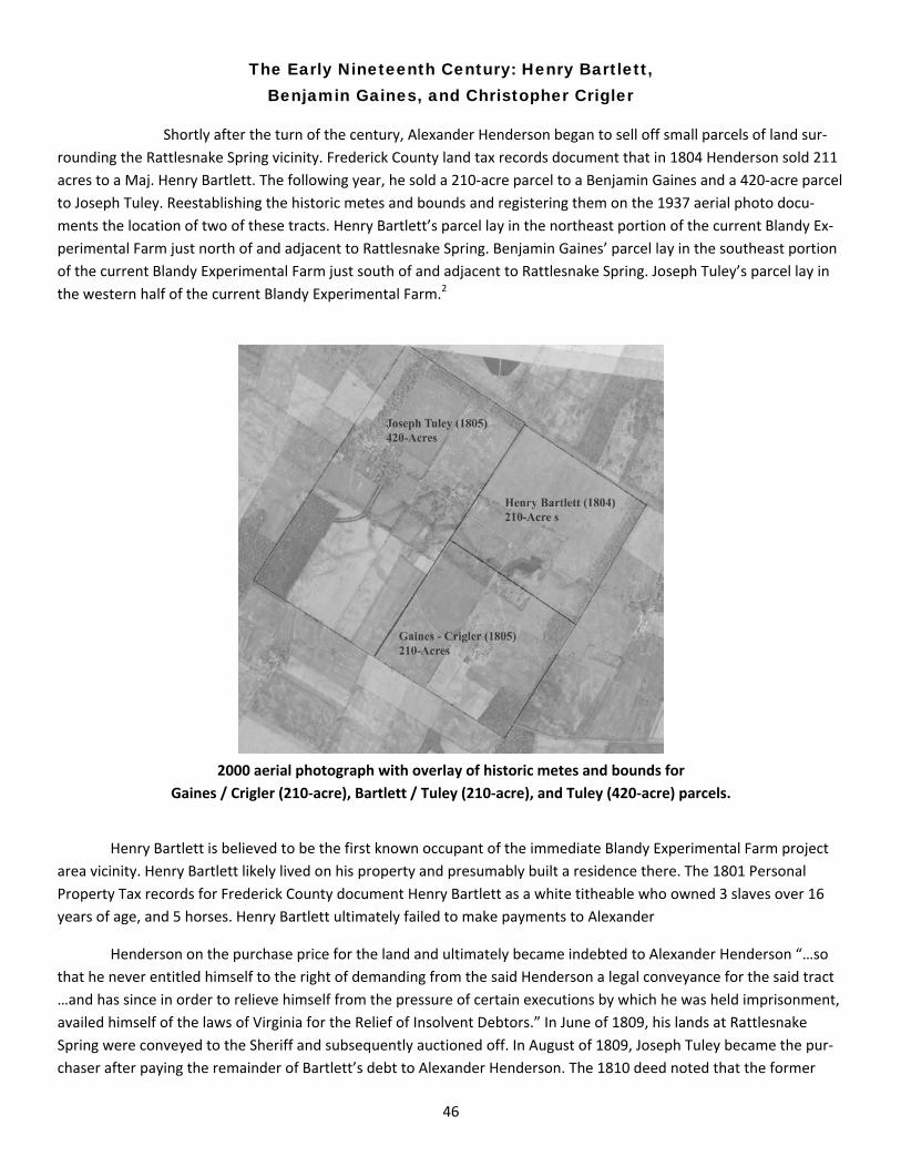
46
The Early Nineteenth Century: Henry Bartlett, Benjamin Gaines, and Christopher Crigler
Shortly after the turn of the century, Alexander Henderson began to sell off small parcels of land sur‐
rounding the Rattlesnake Spring vicinity. Frederick County land tax records document that in 1804 Henderson sold 211
acres to a Maj. Henry Bartlett. The following year, he sold a 210‐acre parcel to a Benjamin Gaines and a 420‐acre parcel
to Joseph Tuley. Reestablishing the historic metes and bounds and registering them on the 1937 aerial photo docu‐
ments the location of two of these tracts. Henry Bartlett’s parcel lay in the northeast portion of the current Blandy Ex‐
perimental Farm just north of and adjacent to Rattlesnake Spring. Benjamin Gaines’ parcel lay in the southeast portion
of the current Blandy Experimental Farm just south of and adjacent to Rattlesnake Spring. Joseph Tuley’s parcel lay in
the western half of the current Blandy Experimental Farm.2
2000 aerial photograph with overlay of historic metes and bounds for
Gaines / Crigler (210‐acre), Bartlett / Tuley (210‐acre), and Tuley (420‐acre) parcels.
Henry Bartlett is believed to be the first known occupant of the immediate Blandy Experimental Farm project
area vicinity. Henry Bartlett likely lived on his property and presumably built a residence there. The 1801 Personal
Property Tax records for Frederick County document Henry Bartlett as a white titheable who owned 3 slaves over 16
years of age, and 5 horses. Henry Bartlett ultimately failed to make payments to Alexander
Henderson on the purchase price for the land and ultimately became indebted to Alexander Henderson “…so
that he never entitled himself to the right of demanding from the said Henderson a legal conveyance for the said tract
…and has since in order to relieve himself from the pressure of certain executions by which he was held imprisonment,
availed himself of the laws of Virginia for the Relief of Insolvent Debtors.” In June of 1809, his lands at Rattlesnake
Spring were conveyed to the Sheriff and subsequently auctioned off. In August of 1809, Joseph Tuley became the pur‐
chaser after paying the remainder of Bartlett’s debt to Alexander Henderson. The 1810 deed noted that the former

47
Bartlett lands were “part of a larger tract known by the name of Rattlesnake Spring tract, or Tanner’s Retreat.”
The metes and bounds of the tract described a line running “through the center of the spring and well,” most likely Rat‐
tlesnake Spring.3
Alexander Henderson formally conveyed the 210‐acre parcel to both Benjamin Gaines and Christopher Crigler
in 1809 only four years after Gaines began to occupy and work the land. Christopher Crigler was Benjamin Gaines son‐
in‐law, married to his daughter Ann Gaines. It is assumed that one or more residences were constructed on the
Gaines / Crigler property shortly after 1805. Benjamin Gaines and Christopher Crigler are both documented in the per‐
sonal property records of the last few years of the first decade of the nineteenth century. These records document that
Benjamin Gaines was a farmer who held four slaves in 1805 and five slaves in 1809. He also had enough horses to work
his land efficiently. These same records show that Christopher Crigler owned no more than one slave and one horse
through 1809. In late 1809 Benjamin Gaines died. His will of October 1808 records that he left all of his real and per‐
sonal property to Christopher Crigler and his heirs, paying “each of my brothers and sisters $100 at the expiration of
twelve months after my decease.” The 1810 personal property records record this inheritance and document a sub‐
stantial personal property increase for Christopher Crigler of six slaves and eight horses.4
Federal census records document that Crigler owned fifteen slaves in 1810 and thirteen in 1820. Apparently
Crigler did not increase the acreage of his small farm during his lifetime. Christopher Crigler died sometime prior to
March of 1822 leaving significant real estate and nineteen slaves. His estate was divided between his wife and at least
seven children. An appraisal of his estate in this year noted twenty‐three slaves, including five men, six women, and
twelve children, and furniture “in the house at Rattlesnake.” The appraisal also documented furniture and furnishings
for possibly more than one residence including five separate bedsteads.5
During the second quarter of the nineteenth century the majority interest in the Crigler property was subse‐
quently acquired by Jemima A. Crigler, a daughter, and her husband John Alexander. Between 1822 and 1836, John
Alexander acquired the interests of Richard, Benjamin, Rheuben and Christopher (Jr.) in the Christopher Crigler (Sr.)
estate.6
John Alexander farmed the Crigler estate from approximately the 1830s to the 1870s. During his tenure the
Crigler – Alexander farm expanded acquiring additional acreage adjacent to his property. Population Statistics docu‐
ment that he held twenty slaves in 1840. Productions of Agriculture records for 1850 document that he worked 450
acres of improved land and 175 acres of unimproved land. His farm was worth $21,741 and included $725 worth of
farm machinery and equipment. Among the livestock he held in 1850 were twenty‐three horses, fourteen milch cows,
thirty‐five cattle, seventy‐five sheep and one hundred pigs, worth approximately $1,900. Ten years later Alexander
owned 800 improved acres and 200 unimproved acres and his livestock was worth $3,575. In 1850, the Crigler – Alex‐
ander farm produced 3,700 bushels of wheat, 1,500 bushels of corn, and eight tons of hay. Productions in 1860 in‐
cluded 3,000 bushels of wheat, 4,000 bushels of corn, 7,000 bushels of oats, and thirty tons of hay.7
Joseph Tuley and “The Grove”
Joseph Tuley first appears in Frederick County records in 1786. During that year he was recorded on a survey as
“Joseph Tuley, tanner of the County of Frederick.” By then, Millwood had a growing commercial center including the
Burwell‐Morgan Mill, a store, blacksmith shop, and distillery. Tuley established his tannery just south of the mill, includ‐
ing the small residence locally referred to as the Tanner’s House, or Toll House. A year later, in 1787, Tuley married Ann
Brownley.8 Within three years, he had constructed a house, now known as “Three Pounds,” on the high bluff across
Spout Run from the mill. Six years later, in 1793, Tuley agreed to a formal 98‐year lease on this two‐acre property from
Col. Nathaniel Burwell. The lease, which refers to the property as a “tanyard,” was effective as of January 1, 1788.9

48
Three Pounds, the Tuley house on the hill behind the Burwell‐Morgan mill at Millwood, as it appeared around 1900.
Personal property tax records for 1801 record Joseph Tuley as owning five slaves and three horses. It is as‐
sumed that the slaves worked for Tuley in his tannery in some domestic capacity and not in agricultural pursuits. In
1802, Joseph Tuley’s father‐in‐law died and he and his wife received a significant amount of cash and additional slaves
at the settlement of John Brownley’s estate in 1805. It is more than likely that this inheritance, and the subsequent sale
of additional lands, assisted in the purchase of land in the Blandy Experimental Farm project area. 10
In 1805, Joseph Tuley purchased a 420‐acre tract, part of the Rattlesnake Spring tract from Alexander Hender‐
son. Five years later in 1810, Joseph Tuley purchased an additional 210 acres, the former Henry Bartlett tract, from
Alexander Henderson. Sometime after 1805, Joseph Tuley immediately set to farming his new lands and within a short
period had built up a considerable fortune. Personal property tax records for the last few years of the first decade of
the nineteenth century document that Tuley owned 10 slaves in 1805 and 1806, 9 in 1809, and 14 in 1810. Federal
Census records for 1810 list a “Joseph Tuley’s Quarter” and documents 1 white male and 11 slaves present. These
same records document that Joseph Tuley owned 40 slaves in 1820. Tuley clearly used his wealth and land to become
one of the region’s leading agricultural producers. By the end of the first quarter of the nineteenth century agricultural
production records show that Frederick County had become the leading producer of wheat and flour in the Common‐
wealth. 11
A limestone double flue central chimney, the remains of a domestic structure located within the southeast cor‐
ner of the 420‐acre Joseph Tuley tract, has been dated from between the late eighteenth to the early nineteenth cen‐
tury. The site and former dwelling may possibly be the residence of an overseer, farm manager, or perhaps a tempo‐
rary pre‐Tuleyries dwelling for Joseph Tuley. Its location on a limestone outcropping on non‐arable land just north of
and adjacent to Rattlesnake Spring make it a likely area for settlement in the first decade of the nineteenth century.12
Sometime between February 1823 and December of 1825, Joseph Tuley died. His will divide his estate between
his wife, several daughters, and only son Joseph Tuley Jr. His wife Nancy received the former 211‐acre Henry Bartlett
Rattlesnake Spring parcel for her natural life, a property that he had named “the Grove.” In addition, she was given sev‐
eral slaves and agricultural produce and equipment. His three daughters, Mary, Belinda, and Sarah were given Virginia
and Kentucky lands, slaves, and stock in the Ashby Gap Turnpike. Joseph Tuley Jr., Tuley’s only son, inherited all of the
residue of his real and personal property including his wife’s 211‐acre Grove parcel after her death.13

49
An appraisal of Tuley’s will in late 1825 documents that he died a man of considerable property. In addition to
numerous farming utensils and equipment he owned fifty‐five slaves, four teams of oxen, twenty‐four cattle, a cow and
calves, seventy‐two sheep, 123 young hogs, one sow with forty‐two pigs, numerous horses, and a significant amount of
agricultural equipment and tools. In addition, his residential furnishings document queensware (Wedgewood em‐
bossed creamware) ceramics, various glassware, a decanter, pitchers, a case of bottles, a mahogany table, a walnut
side board, a bureau, tables, a cherry chest, chairs, a walnut chair, a carpet, six maps and a “prodigal son,” six bed‐
steads and bedding, and a library containing “a number of volumes.” 14
Limestone double flue chimney on the grounds of the Virginia State Arboretum
Joseph Tuley Jr. and Tuleyries
Joseph Tuley Jr. worked to gradually increase his landholdings at Tanner’s Retreat throughout the second quar‐
ter of the nineteenth century. In April of 1826, Joseph Tuley Jr. acquired and additional twenty‐one acres of land to the
southeast of his inheritance entailing portions of the Christopher Crigler estate that was given to Crigler’s daughters
Catharine and Ann. In 1836, he purchased an additional sixty acres from Samuel Bryarly, part of the adjacent “Walnut
Grove” tract. In 1849 he purchased 130 acres from Philip N. Meade, part of the adjacent “Lucky Hit” tract. By mid‐
century, the Tuleyries estate comprised approximately 845 contiguous acres.15
A major phase of construction was initiated by Joseph Tuley Jr. during the second quarter of the nineteenth
century. Sometime between 1825‐1830, the brick ‘Quarters’ structure was likely built. This two story, five bay brick
building in five course American bond possessed two interior end and two interior brick chimneys. It also had a two‐
story porch on its east side. Although there is no evidence to support the possibility that this structure was built to
temporarily house Tuley and his family during the construction of his much larger mansion, the structure is reported to
have subsequently functioned as a slave residence, or quarters, through the antebellum period.16
Sometime after 1825 the construction of the Tuley mansion house was commenced. The large, Federal man‐
sion was built of white painted brick and crowned with an octagonal cupola and dome. The residence was completed
ca. 1833 shortly after Joseph Tuley Jr.’s marriage. Shortly after this, the mansion and larger estate became known as
the Tuleyries.17

50
By the second quarter of the nineteenth century Tuley continued to expand the agricultural potential of his
land holdings creating an expansive and efficient farm centered around the production of wheat and mixed grains. Cen‐
sus records document that he owned 46 slaves in 1830 and 79 in 1840. In 1836 Clarke County was formed from Freder‐
ick County. 18
A visitor to Tuleyries described the extensive property and its unique agricultural system in an 1844 agricultural
farm journal.
The Tuleyries ‐ … The wheat which Col. Tuley has in cultivation is another curiosity. The astonishing
breadth of 800 acres has to be harvested. And such wheat as it is only equaled in this garden spot of the
earth, Clarke County.… The Col. has over 12 miles of stone fencing on his farm, and continues to con‐
struct. This he considers an important operation in as much as it clears farm of rock, saves the timbers
and avoids the necessity of making rails.19
Director’s House, showing ca. late‐nineteenth century brick addition (foreground),
and ca. mid‐nineteenth century stone stable (background).
Federal agricultural production records for Clarke County document that in 1850 Joseph Tuley Jr. had 716 acres
of improved and 150 acres of unimproved land. His farm was worth $44,492, and he possessed $1,000 in farm machin‐
ery and equipment. Among the livestock he held were twenty horses, six asses / mules, twenty‐two milch cows, eight
oxen, thirty cattle, eighty sheep and one hundred pigs, worth approximately $3,500. In 1850, Tuley’s plantation pro‐
duced 7,000 bushels of wheat, 1,750 bushels of corn, 2,000 bushels of oats, and 8 tons of hay. Ten years later, Tuley
had increased his improved land to 800 acres and his plantation produced 6,000 bushels of wheat, 3,000 bushels of
corn, and 100 bushels of oats.20
Sometime during the mid‐nineteenth century the southern portion of the extant Director’s House on the
Blandy Experimental Farm property is believed to have been constructed. Originally built as a stable, this limestone
structure had a brick residence added to its northern end in the late nineteenth century. The stone stable was most
likely converted to a dwelling in early twentieth century. The exterior of the dwelling now contains Craftsman details.21
In 1860 Joseph Tuley Jr. died. An inventory and appraisal of the Joseph Tuley Jr. estate documents an extensive
agricultural system including fifty‐three slaves (32 male, 21 female), thirty‐two cattle and oxen, twenty‐four milch
cows, ninety‐five hogs, eighty‐seven sheep, seventy‐five deer and one elk located in a deer park, a threshing machine
and carriage, three wheat fans, a 3‐horse McCormick reaper, eight wagons, one ox cart, and six ploughs. Shortly after
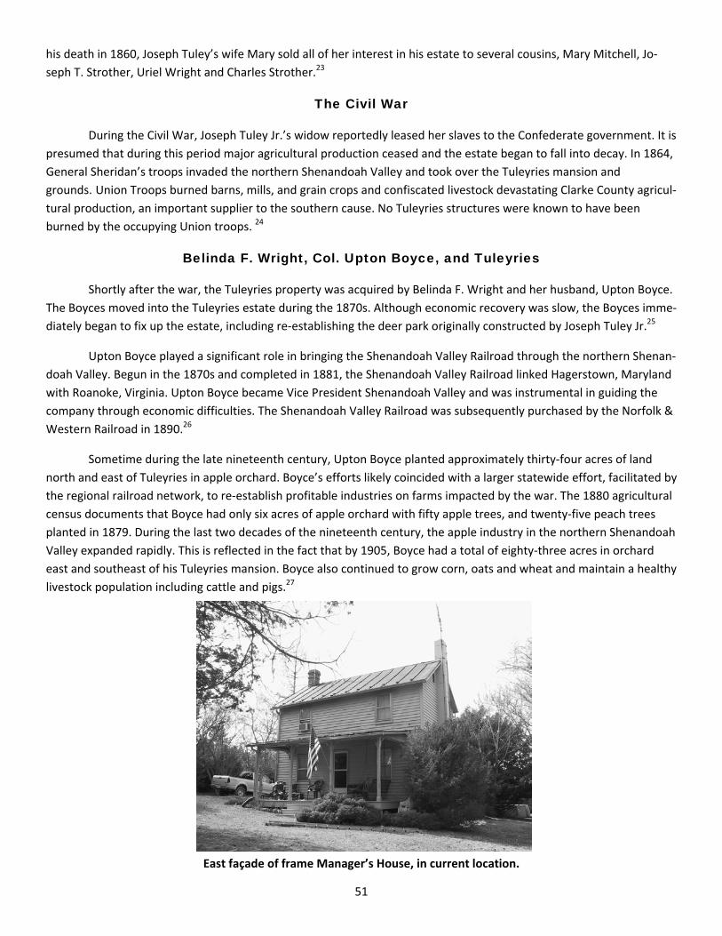
51
his death in 1860, Joseph Tuley’s wife Mary sold all of her interest in his estate to several cousins, Mary Mitchell, Jo‐
seph T. Strother, Uriel Wright and Charles Strother.23
The Civil War
During the Civil War, Joseph Tuley Jr.’s widow reportedly leased her slaves to the Confederate government. It is
presumed that during this period major agricultural production ceased and the estate began to fall into decay. In 1864,
General Sheridan’s troops invaded the northern Shenandoah Valley and took over the Tuleyries mansion and
grounds..Union Troops burned barns, mills, and grain crops and confiscated livestock devastating Clarke County agricul‐
tural production, an important supplier to the southern cause. No Tuleyries structures were known to have been
burned by the occupying Union troops. 24
Belinda F. Wright, Col. Upton Boyce, and Tuleyries
Shortly after the war, the Tuleyries property was acquired by Belinda F. Wright and her husband, Upton Boyce.
The Boyces moved into the Tuleyries estate during the 1870s. Although economic recovery was slow, the Boyces imme‐
diately began to fix up the estate, including re‐establishing the deer park originally constructed by Joseph Tuley Jr.25
Upton Boyce played a significant role in bringing the Shenandoah Valley Railroad through the northern Shenan‐
doah Valley. Begun in the 1870s and completed in 1881, the Shenandoah Valley Railroad linked Hagerstown, Maryland
with Roanoke, Virginia. Upton Boyce became Vice President Shenandoah Valley and was instrumental in guiding the
company through economic difficulties. The Shenandoah Valley Railroad was subsequently purchased by the Norfolk &
Western Railroad in 1890.26
Sometime during the late nineteenth century, Upton Boyce planted approximately thirty‐four acres of land
north and east of Tuleyries in apple orchard. Boyce’s efforts likely coincided with a larger statewide effort, facilitated by
the regional railroad network, to re‐establish profitable industries on farms impacted by the war. The 1880 agricultural
census documents that Boyce had only six acres of apple orchard with fifty apple trees, and twenty‐five peach trees
planted in 1879. During the last two decades of the nineteenth century, the apple industry in the northern Shenandoah
Valley expanded rapidly. This is reflected in the fact that by 1905, Boyce had a total of eighty‐three acres in orchard
east and southeast of his Tuleyries mansion. Boyce also continued to grow corn, oats and wheat and maintain a healthy
livestock population including cattle and pigs.27
East façade of frame Manager’s House, in current location.
52
Sometime during the late nineteenth century, perhaps as a result of the improved agricultural economy, a
wave of significant construction activity took place within and beyond the Tuleyries property. During the late nine‐
teenth century, a brick addition was built onto the north end of the limestone Director’s House. Between 1880–1905,
the extant frame Manager’s House, the former Upton L. Jones ‘Bell‐Bride’ residence, is believed to have been con‐
structed. Originally located southeast of the Quarters approximately 100 yards north of Lake Arnold, the structure was
moved to its current location sometime after 1937. The extant Education Building, originally an apple packing shed, is
also believed to have been built ca. 1900.The construction of this building likely coincided with the maturity of the
Tuleyries apple orchards and the process of harvesting and shipping.28
As a result of a suit between the heirs of Belinda F. W. Boyce, in 1903 the remaining 688‐acre Tuleyries prop‐
erty was divided into four separate portions; 1) a 243‐acre Tuleyries parcel containing the mansion house, 2) a 210‐acre
parcel containing the Upton L. Jones (Bell Bride House) residence, 3) a 96‐acre parcel, and 4) a 139‐acre parcel.
The Garver Farm
In late 1880, Samuel Garver acquired a 7/9 interest in the then 216‐acre Crigler farm property from the estate
of John Alexander. Samuel Garver died sometime in 1881. A valuation of Garver’s 156‐acre estate assessed it at $33 /
acre, or $5,148. By 1887, a half interest in the approximately then 160‐acre Garver farm had passed to Samuel’s son,
Jacob S. Garver. The second half of the interest in the 160‐acre Garver farm was acquired by Jacob in 1904. Between
1887 and 1903, the Garver household is reported to have lived in a small log house. This small log house, and an older
larger log house, are believed to have been the former residences of the Gaines ‐ Crigler ‐ Alexander families. 29
In July of 1903, Jacob Garver and his mother Julia Anderson each acquired a one half interest in a tract adjoin‐
ing the Garver farm from the Belinda F. W. Boyce estate.30 It is during the first decade of the twentieth century that the
Jacob Garver farm complex, consisting of a Victorian vernacular residence, a bank barn, and corn crib, is believed to
have been constructed . Only a year later this 185‐acre parcel, complete with a new residence and agricultural struc‐
tures, was sold to Graham F. Blandy in 1904. 31
Graham F. Blandy and Tuleyries
Graham F. Blandy purchased the 206‐acre mansion house tract from the Belinda F. W. Boyce estate in Septem‐
ber of 1903. In the next few years he actively pursued consolidating the Tuleyries estate acquiring former lands once
owned by the Tuley’s. In 1904, Blandy purchased the 185‐acre Garver farm and an 86‐acre parcel from Uriel Boyce. In
1905, Blandy purchased a 210‐acre tract from Upton L. Jones. During the same year, Blandy purchased the 216‐acre
former Crigler‐Alexander farm from James Garver. In a short span of less than six months Blandy had acquired 505
acres making the Tuleyries property a 912‐acre estate.32
Historic maps from the 1904‐1905 period document the individual landscapes, the 206‐acre Tuleyries, the 210‐
acre Jones, the 216‐acre Garver, and the 264‐acre Boyce / Garver just prior to their purchase and consolidation by
Blandy. The Boyce‐Garver lands map shows the location of a 16.5‐acre functional space containing the Quarters and
Director’s House structures and associated grounds, and the location of the former Tuleyries barns. The Garver Farm
map shows a 2‐acre fenced domestic enclave including a residence and bank barn surrounded on the north by a 17‐
acre orchard. The Jones Farm map shows the location of the Farm Manager’s – Bell Bride House and Rattlesnake
Spring. Each of these maps also designates stone and wire fence lines, historic roads and drives, and which portions of
each property were under cultivation as fields, orchards or wood lots.
After consolidation of the former Tuleyries lands, Blandy had a large‐scale map of his entire estate compiled by
Stuart H. Edmonds in 1905 based on surveys made by Charles Purcell. Of note, two cemeteries are identified, of a
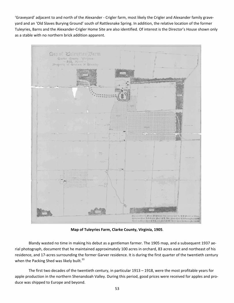
53
‘Graveyard’ adjacent to and north of the Alexander ‐ Crigler farm, most likely the Crigler and Alexander family grave‐
yard and an ‘Old Slaves Burying Ground’ south of Rattlesnake Spring. In addition, the relative location of the former
Tuleyries, Barns and the Alexander‐Crigler Home Site are also identified. Of interest is the Director’s House shown only
as a stable with no northern brick addition apparent.
Map of Tuleyries Farm, Clarke County, Virginia, 1905.
Blandy wasted no time in making his debut as a gentleman farmer. The 1905 map, and a subsequent 1937 ae‐
rial photograph, document that he maintained approximately 100 acres in orchard, 83 acres east and northeast of his
residence, and 17‐acres surrounding the former Garver residence. It is during the first quarter of the twentieth century
when the Packing Shed was likely built.33
The first two decades of the twentieth century, in particular 1913 – 1918, were the most profitable years for
apple production in the northern Shenandoah Valley. During this period, good prices were received for apples and pro‐
duce was shipped to Europe and beyond.

54
Largely due to overproduction, the decline of the apple market began in 1921. During the 1920s, the price per
barrel of apples dropped, the cost of labor increased, the cost of barrels increased, and more prevalent apple diseases
required significantly increased spraying. The apple market was also impacted by World War I and the financial crisis of
1929. By 1930s, standards regulating color, size and quality were imposed as grading and inspections were mandated
and increasing European restrictions on imported agricultural produce limited markets abroad. This resulted in the clo‐
sure of many smaller apple orchards because they could not compete with larger ones.34
During the first two decades of Blandy ownership, Horace J. Martin was the farm manager of Tuleyries.35
Graham F. Blandy died in 1926. His will left 712‐acres of the Tuleyries property, not including the mansion
house and adjacent lands, to the University of Virginia. The will stipulated that the property was to be called the
“Blandy Experimental Farm” with the goal to “teach boys how to farm.” The University of Virginia took possession of
Blandy Experimental Farm in 1926.36
The University of Virginia and the Blandy Experimental Farm
Orland E. White was hired as the first Director of the Blandy Experimental Farm. White occupied the position of
Director for 28 years until his retirement in 1955. In 1927 during the first full season of at Blandy, the premises were
described as “weed filled fields and pasture divided by miles of stone walls” containing scattered old orchards and fruit
trees. The only buildings of substance were the brick Quarters structure, and a stone and brick residence occupied by
Harry Antrim, the farm manager. Antrim was immediately hired as the Blandy farm manager and was placed in charge
of the commercial enterprises of the property. In 1927, White noted that it took $8,000 to run Blandy but that the ap‐
ple crop brought in only $4,000.37
Due to a small budget, only a few improvements were made to the facilities at Blandy during the first years of
operation. In 1928 a new metal roof replaced the old chestnut shingle roof of the Quarters building. A lawn and garden
were planted adjacent to the Quarters, and the field between the Quarters and the Director’s House was plowed for a
garden and experimental plots. In 1830, an exterior stone triple arched stairway was added to the southern façade of
Quarters building. The stairway was built by a Mr. Grubbs.38
In 1929, White began the design and long‐term planting of his Arboretum, a collection of native and exotic spe‐
cies for scientific study. The Arboretum was laid out south and west of the Quarters building. White establishes a long
vista to south and over time removed many of the limestone walls surrounding the Quarters. By the late 1930s, the old
orchards surrounding Quarters building were also gradually removed as planting within the Arboretum expanded.39
Harry Antrim died in 1931 and was replaced by his son, Robert Antrim, as farm manager.40
The earliest aerial photo of the Blandy property was taken in May of 1937, only ten years into the Uni‐
versity of Virginia’s tenure. In the vicinity of the historic core, the photograph shows the Quarters, Director’s House,
Packing Shed, and several unidentified agricultural related outbuildings, three northeast of the packing shed, and one
in the location of the former Tuleyries Barn site. The Jones residence / Bell Bride House is shown in its original location.
At the Garver complex, the Farmhouse, Workshop, Bank Barn, Silo and Corn Crib / House and one unidentified struc‐
ture northwest of the Bank Barn. In addition, the extant circulation and field system and three and a half decade old
orchards are delineated.
Major construction at Blandy was undertaken in 1941. After acquiring his first significant funding earmarked
for expansion, White had significant additions built onto and connecting with the north end of the Quarters. Two brick
wings, a northern and western addition, creating a ‘U’ shaped configuration and central courtyard were added to the
Blandy headquarters (See Figure #28).

55
1937 aerial photograph of Blandy Experimental Farm.
Quarters, looking north, showing northern and western wings.

56
The additions were designed by University of Virginia architect Stanislaw J. Makielski. During the construction,
the original central doorway on west side of the Quarters was bricked in and replaced with a window. A new Green‐
house and plant nursery was also built just northeast of the Quarters building.41
Orland White retired as Director of Blandy in 1955 and was replaced by W. Ralph Singleton. Singleton became
interested in the commercial aspect of the 712‐acre property and decided to build up Blandy’s livestock for both scien‐
tific research and profit. Singleton also decided to harvest agricultural crops on a custom basis with some fields put out
to share. In 1956, the Atomic Energy Commission loaned Blandy a cobalt 60 gamma radiation source and awarded an
annually renewable grant of $16,000. Singleton hired Allan Caspar hired as a technician and a radiation lab was built.
The radiation lab was a concrete and lead lined pit set up in a field. Installation of the lab complete in July of 1957. Over
the next decade, corn was the primary subject of irradiation testing. The radiation lab’s lease expired in 1968 and no
further testing was conducted. Ralph Singleton retired as Director of Blandy in 1965.42
The American Boxwood Society was organized at Blandy in 1961 with a two‐pronged mission of education and
scientific investigation. In 1977, the Boxwood Memorial Garden was established at Blandy. Originally located in the
Amphitheatre vicinity, the Boxwood Memorial Garden was moved to its current location in 1986.43
Thomas E. Ewert was hired as Director of Blandy in 1972. Ewert was given supervision of the day to day opera‐
tion of Blandy while administrative supervision was given to other University officials. By 1973, Ewert decided to rein‐
stitute a teaching program at Blandy and a group of Fairfax Community College students were invited to study farming
practices. In 1976 the decision was made to abandon farming for profit altogether and Blandy leased approximately
500 acres to Edward B. Lee Sr., a local farmer. Approximately 80 acres were set aside for use of Fairfax Community Col‐
lege students.44
In 1985, Edward F. Connor appointed Director of Blandy. Connor was a member of the University’s Environ‐
mental Sciences department. The following year, Blandy Experimental Farm was designated the State Arboretum of
Virginia.45

57
1 Stuart E. Brown, Annals of Clarke County, Virginia. Volume I: Old homes, families, etcetera of the Southern (South of U. S. Route
50) Section, 148. (Berryville, Virginia: Virginia Book Company, 1983); Richard E. Griffith, ‘Tuleyries,’ 49, 51‐52. Proceedings of the
Clarke County Historical Association, Vol. 11 and 12 (1951‐1953). Clark County Historical Association, Berryville, Virginia; Frederick
County Deed Books (FCDB) 23:199; SC3:168. Frederick Winchester Judicial Center, Winchester, Virginia. Note: A 1905 map of the
Tuleyries property and a 1937 aerial photograph indeed show traces of an east‐west oriented fence line running through the mid‐
dle of the Rattlesnake Spring and adjacent pond. 2 Frederick County Land and Property Tax Record Book, 1801 – 1811, Frederick Winchester Judicial Center, Winchester, Virginia. No
deeds from Henderson to either Henry Bartlett (210 acres) or Joseph Tuley (420 acres) during this period could be found. However
land tax records verify that these transactions took place and Henderson’s subsequent sale of the former Bartlett lands to Joseph
Tuley in 1810 document both of the parcel’s locations relative to one another. 3 FCDB 33:19; 32:522; Frederick County Land and Property Tax Record Book, 1801 – 1811, Frederick Winchester Judicial Center,
Winchester, Virginia. 4 FCDB 33:34; Frederick County Land and Property Tax Record Book, 1801 – 1811, Frederick Winchester Judicial Center, Winchester,
Virginia; Frederick County Will Book (FCWB) 8:490. Frederick Winchester Judicial Center, Winchester, Virginia; Brown, Annals, 157. 5 Third U. S. Census, Population Census, Frederick County, 1810; Fourth U. S. Census, Population Census, Frederick County, 1820,
p30; FCWB 11:372. An interest in the 216‐acre Gaines ‐ Crigler estate was purchased by Samuel Garver in 1880. The same land was
sold to Graham F. Blandy in 1905. Crigler is also spelled Criegler in various historical documents. 6 FCDB 46:422; 48:143; 49:21; 50:523; 53:345; and 61:84; Clarke County Deed Book [CCDB] A:1. 7 Sixth U. S. Census, Population Statistics, Clarke County, 1840; Seventh U. S. Census, Non‐Population Statistics, Productions of Agri‐
culture, Clarke County, 1850. Microfilm #1883, Reel 2, 23; Eighth U. S. Census, Non‐Population Statistics, Productions of Agricul‐
ture, Clarke County, 1860. Microfilm #1883, Reel 6, 27. The dramatic increase in productions of agriculture between 1850 and 1860
can be credited to the nearly doubled holdings of improved acreage. 8 Brown, Annals, 148; Griffith, ‘Tuleyries,’ 50‐51. Ann Brownley is frequently referred to as Nancy, a common diminutive for Ann, in
early nineteenth century documents. 9 Griffith, ‘Tuleyries,’ 50; FCDB 24A: 275. 10 Frederick County Land and Property Tax Record Book, 1801 – 1811, Frederick Winchester Judicial Center, Winchester, Virginia;
Brown, Annals, 148; Griffith, ‘Tuleyries,’ 51; FCDB 33:92. 11 Brown, Annals, 148; Griffith, ‘Tuleyries,’ 50‐52; Kalbian, ‘Blandy Experimental Farm Historic District,’ 8‐17; Third U. S. Census,
Population Census, Frederick County, 1810; FCDB 32:522; Hofstra, Separate Place, 25; Brown, Annals, 148; Fourth U. S. Census,
Population Statistics, Frederick County, 1820, p30. 12 Maral Kalbian, ‘Blandy Experimental Farm Historic District,’ 7‐10. National Register of Historic Places Registration Form, 1992.
VDHR File No. 21‐550. Ms. on file at the Library and Archives, Virginia Department of Historic Resources, Richmond, Virginia. 13 Kalbian, ‘Blandy Experimental Farm Historic District, 8‐17; Griffith, ‘Tuleyries,’ 52; FCWB 13:43. 14 FCWB 14:52. 15 Griffith, ‘Tuleyries,’ 54, 58; FCDB 51:343. 16 Kalbian, ‘Blandy Experimental Farm Historic District, 7‐3. There is no documentary evidence supporting the use of the Quarters
building as a slave residence, only that it has been called the Quarters since sometime in the nineteenth century. The building is
certainly of unusual construction for a slave quarters during this period, being a two‐story brick structure. 17 Brown, Annals, 148; Griffith, ‘Tuleyries,’ 55; Department of Historic Resources, ‘The Tuleyries,’ DHR ID# 021‐0082. Site form on
file at the Library and Archives, Virginia Department of Historic Resources, Richmond, Virginia. 18 Fifth U. S. Census, Population Statistics, Frederick County, 1830; Sixth U. S. Census, Population Statistics, Clarke County, 1840. 19 Griffith, ‘Tuleyries,’ 73 fn. 19. 20 Seventh U. S. Census, Non‐Population Statistics, Productions of Agriculture, Clarke County, 1850. Microfilm #1883, Reel 2, 27;
Eighth U. S. Census, Non‐Population Statistics, Productions of Agriculture, Clarke County, 1860. Microfilm #1883, Reel 6, 22. 21 Kalbian, ‘Blandy Experimental Farm Historic District, 7‐6, 7‐7.
Endnotes

58
23 Kalbian, ‘Blandy Experimental Farm Historic District, 8‐17; Griffith, ‘Tuleyries,’ 60; CCDB G:148. 24 Brown, Annals, 151. 25 Griffith, ‘Tuleyries,’ 61; Brown, Annals, 151. 26 Brown, Annals, 151‐152. 27 John D. Boyer, Geographical Analysis of Viticulture Potential in Virginia, 70. Ms. Thesis, Virginia Polytechnic Institute and State
University, 1998; Tenth United States Census, 1880. Productions of Agriculture, Clarke County, Virginia, Microfilm #1883, Reel 22. 28 Kalbian, ‘Blandy Experimental Farm Historic District,’ 7‐7, 7‐8, 7‐9. Subsequent additions to the farm complex included a tile silo
(ca. 1910‐1925), a sheep shed (ca. 1955), and a workshop (ca. 1960). 29CCDB P:252; Q:260; X:588; Z:418; Brown, Annals, 158. Dennis Heflin, the Blandy Experimental Farm Buildings Superintendent,
reported that a farmer that used to lease the land that the Crigler Farm occupied reported hitting stone remains of a foundation or
chimneys while plowing his fields. A 1905 map of Tuleyries documents the general location of the ‘old chimneys’ of the former
Alexander – Crigler residence. 30 CCDB Z:24. 31 Kalbian, ‘Blandy Experimental Farm Historic District,’ 7‐7; CCDB 2:417. 32 Griffith, ‘Tuleyries,’ 62; CCDB 2:92, 417, 443, 496, 597. 33 Stuart H. Edmonds, Map of Tuleyries Farm. Clarke County, Virginia. 912 Acres. Property of Graham F. Blandy. Assembled by Stuart
H. Edmonds from surveys made by C. H. Purcell. Stuart Brown Collection, Clarke County Historical Society, Berryville, Virginia. 34 Boyer, Geographical Analysis, 71. 35 Brown, Annals, 61. 36 Kalbian, ‘Blandy Experimental Farm Historic District,’ 8‐18. 37 Thelma Schmidhauser, “A History of Blandy,” np. Ms. at the Blandy Library, Blandy Experimental Farm, Boyce, Virginia. 38 Schmidhauser, ‘History,’ np; Kalbian, ‘Blandy Experimental Farm Historic District,’ 7‐4. 39Schmidhauser, ‘History,’ np; Kalbian, ‘Blandy Experimental Farm Historic District,’ 8‐20. 40 Schmidhauser, ‘History,’ np. 41 Kalbian, ‘Blandy Experimental Farm Historic District,’ 7‐5. 42 Schmidhauser, ‘History,’ np. 43 American Boxwood Society, ‘Boxwood Memorial Garden, State Arboretum of Virginia at the University of Virginia’s Historic
Blandy Experimental Farm,’ February 2006. Pamphlet available at the Blandy Experimental Farm, Boyce, Virginia. 45 Schmidhauser, ‘History,’ np; Kalbian, ‘Blandy Experimental Farm Historic District,’ 8‐20, 8‐23.
.
59
Selected Index 2nd Virginia Regiment 12, 14
11th Virginia Regiment 13, 15 15th Virginia Regiment 15 4th Virginia Regiment 15
8th Virginia Regiment. 13
Abbe, Cleveland, Professor 28
Adit 33
Aerial Photograph 46, 53, 54, 55
Agnew, Wing G. 33, 34 Agriculture Appropriations Bill 31
Alexander Family Graveyard 53
Alexander, John 47, 52
Allen, Herbert F.L. 24, 36
Allen, Mavin (Mrs. Herbert F.L) 24
American Boxwood Society 56
American Friends Service Committee 34
American Institute of Architects 27, 28
American Legion 32, 33
American Revolutionary War 8‐22, 45 Anderson Graveyard 14 Anderson, Joseph 10, 14
Anderson, Julia 52
Antrim, Harry 54
Antrim, Robert 54
Apple orchards 51, 52, 53, 54
Apple production 51, 52, 53, 54
Arboretum 54
Army Corps of Engineers 35, 39
Ashby Gap Turnpike, stock 48
Assistant Attorney General 31
Atlantic Ocean 26
Atomic Energy Commission 56 Bacon 17
Balloon House 25, 26 Baptists, persecution of 17
Barns, Blandy Experimental Farm 53, 54
Bartlett, Henry Major 46, 47, 48 Beef 12, 16, 17
Bell‐Bride House (Manager's House) 52, 54, 55 Berry, Benjamin 10, 16 Berryville Baptist Church Cemetery 10, 16 Berryville, VA 16 Biggs, Benjamin 16
Blakemore 14 Blakemore Cemetary 14 Blakemore farm 10 Blakemore, George 10, 14 Blakemore, Thomas 14 Blakemore, Thomas, Sr. 10, 14
Blandy Experimental Farm 45, 46, 48, 50, 54, 55, 56
Blandy, Graham F. 45, 52, 53
Blasting 33, 34
Blue Ridge Mountains 26
Bluemont, VA 24, 30, 34
Boston Opera House 28
Boston Society of Architects 27
Boston, MA 9, 27, 28
Boxwood Memorial Garden 56
Boyce, Upton 51
Boyce, Uriel 52
Brethren Service Committee 34, 39 British Army 11, 12, 14
Brownley, Ann (Mrs. Joseph Tuley) 47
Brownley, John 48
Bruin, Peter Byron, Captain 13
Bryarly, Samuel 49 Buck Marsh Baptist Church Ceme‐tery 16, 17 Buck, Thomas Fayette 14 Buck, Thomas, Captain 13
Buck’s Minute Men 13
Bunker Hill, Battle of 12 Burwell ‐ Morgan Mill 11, 47, 48
Burwell, Robert 45
Burwell, Robert C. 45 Burwell,Nathaniel 10, 11, 45, 47 Butler, Lawrence 10, 15 Byrd Farm 14
Byrd, Harry F., Governor of VA 32 Byrd, Thomas 10, 11 Calmes, Marquis 10,11 Calmes, Marquis, IV 11 Calmes, Winifred 11 Captain Stith's Company 15
Carlin, Charles C., US Rep. VA 29, 31, 37 Carter Hall 11
Carter, Robert "King" 45

60
Caspar, Allan 56
CCC Camp, Front Royal, VA 33, 34
cemeteries 10, 11,12, 13, 14, 15, 16, 17, 52, 53
Chandler family cemetery 10
Chandler, Carter B. 10, 15
Charleston, SC 15
Cherry Hill Farm 16
Chief Architect of the Treasury Department
28
civil defense workers 35
Civil War 51
Civilian Conservation Corps (CCC)
33, 38
Civilian Public Service (CPS) Camp
34, 39
Clagett farm (Springfield) 10,14
Clarke County, Formation 50
Clarke County, Virginia 9, 10, 11, 14, 18, 24, 29, 32, 35, 50, 51, 53
Classical Revival Architecture 28
Cobalt 60 56
Commonwealth of Virginia 31, 32, 33, 34, 38, 48
Confederate Government 51
Connor, Edward F. 56
conscientious objectors 34, 39
Continental Army 11, 12, 13
Continental Congress 12
Coolidge, Calvin, President 31, 37, 38
Corn 17, 47, 50, 51, 56
Cornwallis, General 14
Crigler / Alexander Farm 47, 52, 53
Crigler Family Graveyard 53
Crigler, Ann 49
Crigler, Benjamin 47
Crigler, Catherine 49
Crigler, Christopher 46, 47, 49
Crigler, Christopher, Jr. 47
Crigler, Jemima A. (Mrs. John Alexander)
47
Crigler, Rheuben 47
Crigler, Richard 47
Culpepper, VA 17
Daughters of the American Revolution
10, 17
Dearmont Farm 15
Declarations of Taking 35
Deerfield 15, 16
Edmonds, Stuart H. 52
Education Building, Blandy Experi‐ 52, 55
Environmental Sciences 56
Estate, Joseph Tuley, Jr. 50
Estate, Mrs. Belinda F.W. Boyce 52
Estate, Samuel Garver 52
Ewert. Thomas E. 56
Executive Office of the President 35
Fairfax Community College 56
Farm Manager, Blandy Experimen‐ 52, 54
Federal Census records 47, 48, 50
Federal Civil Defense Administra‐tion 35
Federal Distric Court 35
Federal Emergency Management 35, 39
Federal Emergency Relief Admini‐ 33, 38
Fithian, Philip 9
Fletcher, J.C. , Surveyor 24 Flour 13, 17, 48
Fowler, J. E. 35 Frederick County, Virginia
13, 15, 45, 46, 47, Frederick Militia 16, 17
French and Indian War 11, 13
Front Royal, VA 33, 34 Frost graveyard 10, 17 Frost, William 10, 17
Gaines / Crigler Property 47
Gaines, Ann (Mrs. Christopher Crigler) 47
Gaines, Benjamin 46, 47
Gamma Radiation 56
Garver Farm 52, 53, 54, 55
Garver, Jacob S. 52
Garver, James 52
Garver, Samuel 52
Georgia 34 Germantown, Battle of 14 Gibson, John, Col. 16
Gilpin, Kenneth N. 35
Governor of Virginia 12
Director, Blandy Experimental Farm 54, 56
Director's House, Blandy Experi‐mental Farm
50, 52, 53, 54, 55
Drilling 33, 34

61
Grace Episcopal Church Cemetery 10, 16
Great Depression 33, 54 Green Hill Cemetery 10, 16 Green, Nathanael, General 14 Greenhouse, Blandy Experimental Farm 56 Greenway Court 10, 17
Gregg, W.R. 33
Grubbs, Mr. 54
Hagerstown, MD 51 Handley Regional Library 16 Hay 17, 47, 50
Helvestine farm 15
Henderson, Alexander 45, 46, 47, 48 Hiram Lodge Masonic Temple, Win‐chester, VA 28
Hobos 33 Hoover, Herbert, President
31, 38
Horses 46, 47, 48, 49, 50
Hospital 32, 33, 37
House Bill 2869 37
House Committee on Agriculture 27, 31, 38
House Committee on Expenditures 27
House Joint Resolution 89 32
House Judiciary Committee 31
Houston, D.F. 29
Humphrey, Thomas 24 Hunsicker, Daniel 13
Hunsicker, Peter 8, 10, 13 Ireland, James 10, 16
Irradiation Research 56
Jackson, Frank H. 27, 28 Jackson, Thomas 10, 16
James City County 11 James City County Committee of Safety 11 Jefferson County, West Virginia 11
Jones, Upton L. 52
Joseph Tuley’s Quarter (the Quarters) 48, 49 Kearfoot, William 10, 15
Kelley Family (Kelly Family) 24
Kelley, William 24
Kelly Family (Kelley Family) 24
Kelly, George W. 24, 36 Kentucky 11, 48
Kite Reel Shed 25, 26, 36 Lafayette, Marquis de 14
Lake Arnold 52
Land Bounty 15
Land Tax Records 46
Lee, Edward B., Sr. 56 Lerue, Isaac 10, 17 Lewis farm (The Moorings) 10 Lewis, Lorenzo, Mrs. 17
Littlefeild (US Rep. Maine) 27
Long Branch 45
Loudoun County Post of the American 33
Loudoun County, VA 24, 29, 32, 34, 35,
Loudoun Valley 29
Lucky Hit, house 12, 49
Lynchburg, VA 35
Magnet Houses 26, 27, 36
magnetism, research 26, 27, 36
Makielski, Stanislaw J. 56
Manager's House, Blandy Agricultural 51, 52, 55
Maps, Blandy Experimental Farm 52, 53
Martin, Horace J. 54 Martin, Thomas B. 10, 17
Marvin, C.W. 37
Mayflower presidential yacht 31
McCormick Reaper 50 Meade Church Cemetery 10, 11, 12
Meade Memorial Church 11, 12
Meade Memorial Episcopal Church 12 Meade, Humberson 10,11
Meade, Philip N. 49 Meade, Richard 10, 12
meteorological balloon 24, 25, 28, 29
meteorological kite 24, 25, 26, 28, 29,
Meteorology 24, 26, 28, 29, 30,
Michael, William H. 24 Middle Farm 17 Millwood, Virginia 11, 47, 48
Mining, research 33, 34, 38
Mitchell, Mary 51 Monmouth, Battle of 14
Moore, Willis, Professor 23, 26, 27, 29 Moorings, The (Lewis Farm) 10
Morgan Riflemen 9
Morgan, Daniel 9, 11, 13
Morgan's Mill 24

62
Mt. Weather Emergency Operations Center 35
Mt. Weather, Buildings
24, 25, 26, 27, 28, 29, 30, 32, 33, 35, 36, 37, 39
Mt. Weather, Fire 27, 36 Muse, Battalle 10,11 Mutton 14, 15
National Archives 33
Natural disasters 35
New York 27
Norfolk & Western Railroad 51
North Carolina 34
Norton, John Hattley 45
Oats 47, 50, 51
Observatory 26
Office for Emergency Management 35
Office of Civil and Defense Mobilization 35
Office of Civil Defense 35
Office of Defense and Civilian Mobilization 35 Old Buck Marsh Meeting House 10 Old Chapel Cemetery
10, 11, 12
Old Slaves Burying Ground 53
Omaha, NE 29, 30
Overseer 45, 48
Packing Shed, Blandy Experimental Farm 53, 54, 55
Paris, VA 24, 36 Pasturage 17
peace churches 34
Peach Orchards 51 Pension Records 15
Personal Property Tax Records 46, 47, 48
Plaster, George E., Dr. 24
Poet League 33
Poole, Robert Evans 34
postcard 28, 29
President of the United States 29, 31
Prison 31, 37, 46 Prisoners of War 14, 15 Private Cemeteries 14, 15
Public Buildings and Parks Department 38
Public Service camps 34 Public Service Claims 14
Purcell, Charles 52
Radiation Lab, Blandy Experimental Farm 56
Rail lines 30, 31, 51 Randolph, Edmund Jennings 10, 12
Rattlesnake Spring 45, 46, 47, 48, 53
Reed, William 12 . 13
Reformatory 31, 37 Richmond, VA 14
road improvements 24, 31, 33, 34, 36, 38
roads 24, 30, 31, 33, 34, 36, 38
Roanoke, VA 51
Roosevelt Administration 33
Roosevelt, Franklin D. , President 33
Ross, T. 24
Rouss City Hall, Winchester, VA 28
Route 601 36
Royal Meteorological Society of Lon‐28 Secretary of Agriculture
24, 29, 30, 31, 32, 33, 36, 37
Secretary of State 12
Secretary of the Army 35
Shenandoah Valley 29, 51, 53
Shenandoah Valley Railroad 51
Sheridan, Philip General 51
Sherriff 46
Singleton, W. Ralph 56
Slaves 45, 46, 47, 48, 49, 50, 51, 53
Smith, John Frederick 13 Smith, William 16
Smithsonian Institution 23
Snickers, Edward 45
Soil Conservation Service 34, 39
Sons of the American Revolution 10 South Carolina 14, 15
Speaker of the U.S. House of Repre‐ 24
Spout Run 47 Springer, Uriah 16
Springfield (Clagett Farm) 14
Stable 50
state attorney general 12
Steuben , Friedrich Wilhelm von, 12
Stevens, Robert T. 35 Stith, John Captain 15
Stones Chapel 8, 12, 13
Strother, Charles 51
Strother, Joseph T. 51
Summer Residence 29, 31, 37, 38
Summer White House 29, 31, 37, 38 Supplies to Continental Army 12, 13, 14,15, 16,
17
63
Swanson, Claude, Senator (VA) 29, 37
Symons Gold medal 28
Tanner 47
Tanner's House (Toll House) 47
Tanner's Retreat 47, 49
Tannery 47, 48
Tarnsey Act 28
Tennessee 34
Terrorism 35
The Grove 47, 48
The Quarters 48, 49, 52, 54, 55, 56
Thomas Fairfax, Lord 17
Three Pounds 47, 48
Titheables 46
Toll House (Millwood) 47
Trapp, VA 24
Tuberculosis 32, 33, 37
Tuley, Belinda 48
Tuley, Joseph 45, 46, 47, 48
Tuley, Joseph, Jr. 48, 49, 50, 51
Tuley, Mary 48
Tuley, Mary (Mrs. Joseph Tuley, Jr.) 51
Tuley, Nancy, (Mrs. Joseph Tuley, Jr.) 48
Tuley, Sarah 48
Tuleyries ( mansion house) 49, 50, 51, 52, 53
Tuleyries (estate) 48, 49, 50, 51, 52, 53, 54
Tunnels, Mt. Weather 33, 34, 38
TWA Airplane Crash (Flight 514) 39
U. S. Army Signal Corps 23
U. S. Bureau of Mines 33, 34, 38, 39
U. S. Department of Agriculture
23, 24, 27, 29, 30, 31, 32, 33, 36, 37, 38
U. S. Veterans Hospital 33
U. S. Weather Bureau 23, 24, 26, 29, 33, 36, 37, 38
U.S. Department of Defense 35
U.S. Department of Homeland Security 35, 39
U.S. Department of the Army 35
U.S. Department of the Interior 33
Union Troops 51
United State Senate 29, 32
United State Treasury Department 28
United States House of Representatives 27, 29, 30, 31, 32, 36, 37, 38
United States of America, property owned by 24, 32, 34, 35
University of Virginia 54, 56 Valley Forge 14
Veterans, WWI 32, 33, 37 Vineyard, The 11
Virginia Constitution 12
Virginia Declaration of Rights 12
Virginia State Arboretum 45, 49, 54, 56 Wagons 12, 17, 50
Wallace, Henry A. 33
Walnut Grove 49
Washington, D.C. 26, 27, 30, 31, 32, 33
Washington, George 12
Weather station 24, 26, 29, 30, 31, 35, 36, 38
Wellebrandt, Mabel Walker 31
Wheat 47, 48, 50, 51 Wheeler Farm (Deerfield) 15, 16 Whiskey 14, 17 White Post Cemetery 10 White Post, Virginia 11, 12, 17
White, Orland E. 54, 56
Wiley, Earl W. 35
Wiley, Sam 24
Will, Benjamin Gaines 47
Will, Graham F. Blandy 54
Will, Joseph Tuley 48, 49 Williamsburg, Virginia 11 Wilson, James, U.S. Secretary of Agri‐culture 26
Winchester, Virginia 9, 28
Work Camp 33
Works Progress Administration 33, 38
world record 26, 28
World War I 32, 37, 54
World War II 34
Wright, Belinda F. (Mrs. Upton Boyce) 51, 52
Wright, Uriel 51 Yorktown, Siege of 12, 14, 16 Yorktown, Virginia 12, 14, 15
64
Notes to Proceedings V. XXVIII:
Citations in endnotes and bibliographies are as submitted by the author.
Front matter (pp 1—7), endnotes and bibliographies have not been indexed.
Image use permissions obtained by the authors, except where CCHA images have been used.
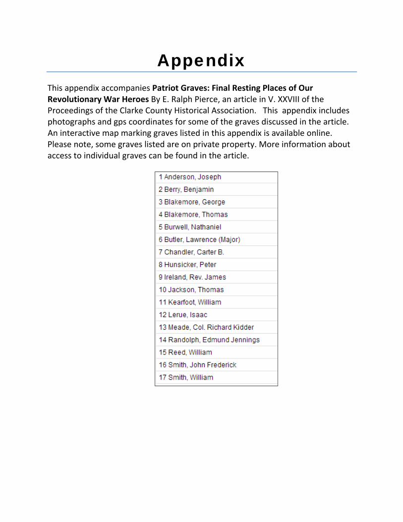
Appendix This appendix accompanies Patriot Graves: Final Resting Places of Our Revolutionary War Heroes By E. Ralph Pierce, an article in V. XXVIII of the Proceedings of the Clarke County Historical Association. This appendix includes photographs and gps coordinates for some of the graves discussed in the article. An interactive map marking graves listed in this appendix is available online. Please note, some graves listed are on private property. More information about access to individual graves can be found in the article.
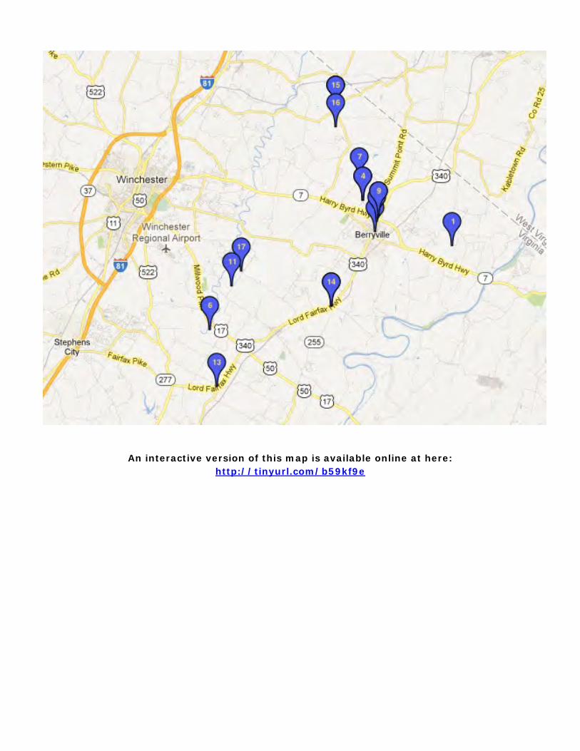
An interactive version of this map is available online at here: http://tinyurl.com/b59kf9e

1. Anderson, Joseph – Springfield Farm
GPS location –
Lat: N 39 degrees, 8 min., 51.6 seconds
Lon: W 77 degrees, 55 min., 23.5 seconds
The Anderson cemetery is a family cemetery located on the Clagett farm, “Springfield.”
Photograph of the Anderson cemetary taken by Winter & Ruth Royston in 1969.
CCHA Archives, 2004.00012.055.E
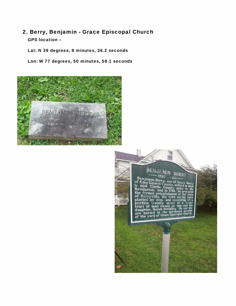
2. Berry, Benjamin - Grace Episcopal Church GPS location –
Lat: N 39 degrees, 8 minutes, 36.2 seconds
Lon: W 77 degrees, 50 minutes, 58.1 seconds

3. Blakemore, George – Blakemore Cemetery
GPS location –
Lat: N 39 degrees, 10 minutes, 20.3 seconds
Lon: W 77, 59 minutes, 24.4 seconds
4. Blakemore, Thomas – Blakemore Cemetery
GPS Location –
Lat: W 39 degrees, 10 minutes, 21.6 seconds
Lon: W 77 degrees, 59 minutes, 24.6 seconds

5. Burwell, Nathaniel – Old Chapel Cemetery
GPS Location –
Lat: N 39 degrees, 6 minutes, 25.0 seconds
Lon: W 78 degrees, 0 minutes, 51.0 seconds
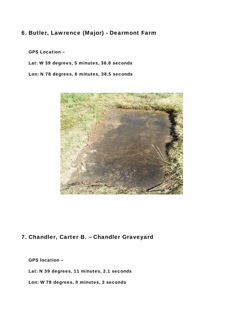
6. Butler, Lawrence (Major) - Dearmont Farm
GPS Location –
Lat: W 39 degrees, 5 minutes, 36.8 seconds
Lon: N 78 degrees, 6 minutes, 38.5 seconds
7. Chandler, Carter B. – Chandler Graveyard
GPS location –
Lat: N 39 degrees, 11 minutes, 2.1 seconds
Lon: W 78 degrees, 0 minutes, 3 seconds

8. Hunsicker, Peter – Stones Chapel
GPS location -
Lat: N 39 degrees, 13 min., 36.5 seconds
Lon: W 78 degrees, 0 min., 37.6 seconds

9. Ireland, Rev. James- Buck Marsh Baptist Church
GPS Location –
Lat: N39 degrees, 9 minutes, 47.3 seconds
Lon: W77 degrees, 58 minutes, 37.2 seconds
The exact location of the Buck Marsh Baptist Church is not known. The approximate of the location of the old church is memorialized by the monument pictured below, and located at the associated GPS location.
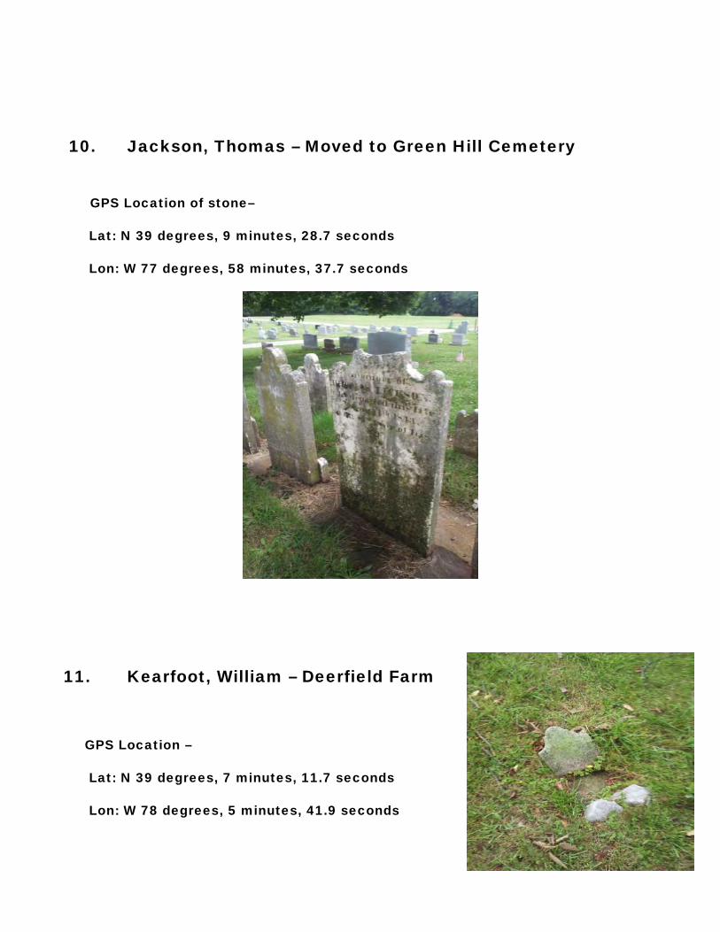
10. Jackson, Thomas – Moved to Green Hill Cemetery
GPS Location of stone–
Lat: N 39 degrees, 9 minutes, 28.7 seconds
Lon: W 77 degrees, 58 minutes, 37.7 seconds
11. Kearfoot, William – Deerfield Farm
GPS Location –
Lat: N 39 degrees, 7 minutes, 11.7 seconds
Lon: W 78 degrees, 5 minutes, 41.9 seconds
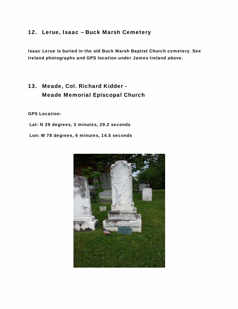
12. Lerue, Isaac – Buck Marsh Cemetery
Isaac Lerue is buried in the old Buck Marsh Baptist Church cemetery. See Ireland photographs and GPS location under James Ireland above.
13. Meade, Col. Richard Kidder - Meade Memorial Episcopal Church
GPS Location:
Lat: N 39 degrees, 3 minutes, 29.2 seconds
Lon: W 78 degrees, 6 minutes, 14.5 seconds

14. Randolph, Edmund Jennings – Old Chapel Cemetery
GPS Location –
Lat: N 39 degrees, 5 minutes, 56.6 seconds
Lon: W 78 degrees, 0 minutes, 50.9 seconds

15. Reed, William – Stones Chapel
GPS location –
Lat N 39 degrees, 13 min., 35.7 seconds
Lon W 78 Degrees, 0 min., 38.0 seconds
16. Smith, John Frederick – Stones Chapel
GPS location –
Lat N 39 degrees, 13 min., 36.2 seconds
Lon W 78 degrees, 0 min., 36.9 seconds
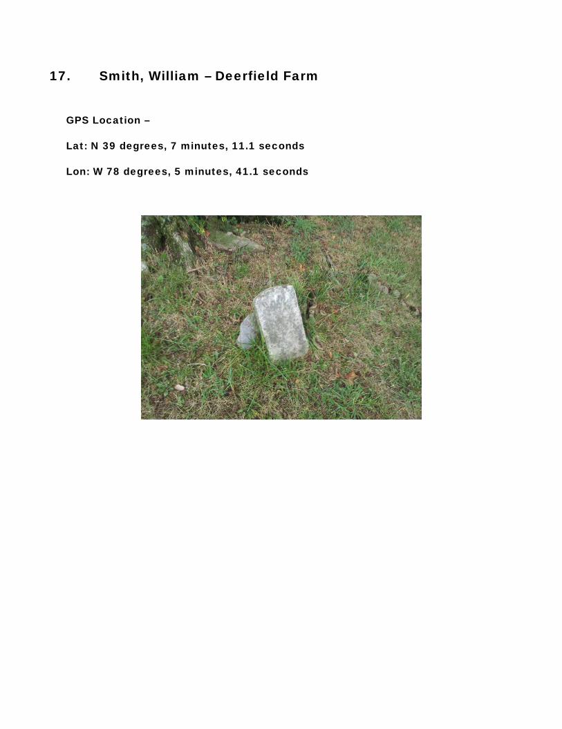
17. Smith, William – Deerfield Farm
GPS Location –
Lat: N 39 degrees, 7 minutes, 11.1 seconds
Lon: W 78 degrees, 5 minutes, 41.1 seconds