cleadon tower: historic building recording · south tyneside, tyne and wear historic buildings...
TRANSCRIPT
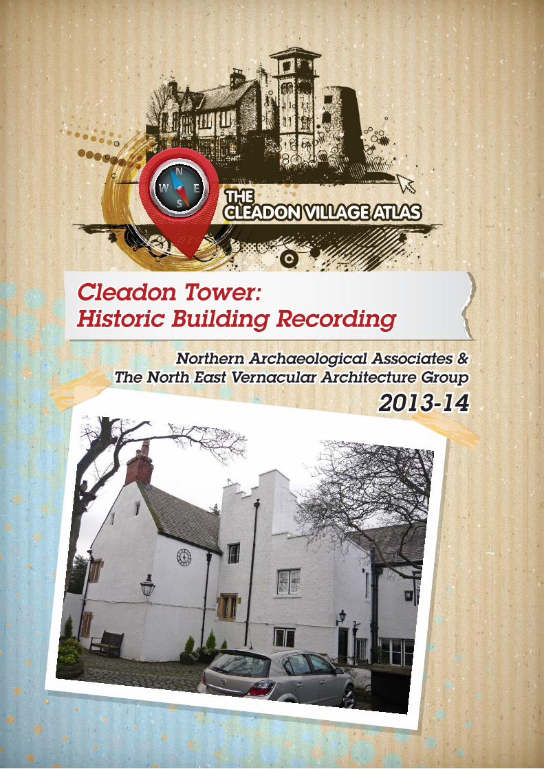
Cleadon Tower: Historic Building Recording
Northern Archaeological Associates &The North East Vernacular Architecture Group
2013-14

This document has been approved for release by: ..……………………….……….
NAA Document Authorisation
Project name
Cleadon Village Atlas - Cleadon Tower Building Recording Project number
1133 Report title Cleadon Tower Historic Building Recording
Report No. 03/15
Revision Date Filename 1133_Rpt_03-15_Cleadon VA Cleadon Tower BR.pdf
v. 1 v. 2 v. 3 v. 4
10/06/13 26/11/15 02/01/16 13/04/16
Description Report of building recording undertaken by NAA and NEVAG as part of the Cleadon Village Atlas Project
Prepared by Edited by Approved by
Name Penny Middleton
Martin Roberts
Florence Spaven/Martin Roberts/Gavin & Eileen Spencer
Richard Fraser
©Northern Archaeological Associates Ltd and NEVAG 1
CLEADON TOWER, CLEADON,
SOUTH TYNESIDE, TYNE AND WEAR
HISTORIC BUILDINGS RECORDING
Summary
As part of the Cleadon Village Atlas project, a team of local volunteers from the village joined together with
members of the North East Vernacular Architecture Group (NEVAG) to carry out a programme of historic
building recording at Cleadon Tower; a building at the centre of the village, parts of which were believed to
date back to the 16th century or earlier.
The property is thought to be the oldest surviving building in the village, and occupies a linear plot, running
north to south from Front Street. This was one of the original medieval land plots set out when the village was
established, probably in the 12th or 13th century. The present house is an L-shaped building comprising a
north range - orientated north to south along the western edge of the land plot, with the gable end facing onto
the street - and south range, running east to west. The tower, from which the property derives its name, was
located to the east of the south range and is believed to have been medieval in origin, but was demolished in
the early 19th century. The staircase between the ranges was extended into a mock tower in 1890.
Cleadon Tower was built for the Chambers family; one of the most important and influential families in the
parish of Whitburn. The family originally came from Alnwick in Northumberland, and may have come to the
area as part of Baron Hylton's retinue. Indeed, it is possible that Cleadon Tower was first built around the
same time as Hylton Castle, in the early 15th century, but there is no direct evidence of this. The first
documentary reference to the Chambers 'of Cleadon' is 1509 when John Chambers is listed as the village
Collector. This was a rent collector; a position of considerable status and influence during the medieval
period. The family continued to be associated with the property until the early 18th century when the estate
was sold. The Chambers coat of arms appears above a 17th century fireplace on the first floor; one of the
most significant features of the property.
There is no surviving above ground evidence of the medieval tower but, based on description by the
historians Surtees and Hutchinson, both of whom recall the building when it was still standing, it was located
to the east of the current house. Surtees describes it as a two floored tower with and a stone spiral staircase. It
was probably a solar tower; a stone tower attached to a timber hall which provided living accommodation
for the lord and his immediate family. Later the timber hall was replaced by a 'new' manor house, comprising
the two stone-walled ranges extant today: a south hall and chamber range with a service wing set at right
angles to it. This was probably during the 16th century. The property seems to have been expanded during
the 17th century, possibly as the result of damage during the Civil War. There were also other phases of later
modification, most notably in the late 19th century and in the mid 20th century. However, despite these
changes the building still retains a number of features of considerable heritage significance covering several
Cleadon Tower, Cleadon, South Tyneside: Archaeological Buildings Recording
©Northern Archaeological Associates Ltd and NEVAG 2
different periods including: the 16th century kitchen range; the 17th century coat of arms fireplace; late 17th
or early 18th century doors; and 18th century marble fireplace (not original to the property).
Similarly, the exterior of the property includes a number of key features. Some elements have been replaced,
including the majority of the windows and the main south-facing door, but in a manner sympathetic to the
original property, retaining the earlier fenestration pattern and overall architectural style of the building. As
such, there can be little doubt that Cleadon Tower makes a valuable contribution to the visual setting and
historic character of the village core. It is also significant in terms of our appreciation of the overall form,
foundation, and subsequent development of the of settlement and understanding of the history of the Cleadon
as a whole.
Acknowledgements
NAA and NEVAG would like to thank the owners of Cleadon Tower, Mr and Mrs Spencer for their kindness
in allowing access and giving the recording team such a warm welcome on the survey day. Thanks also to
all the volunteers: Andrea George, Hilary Davison, Carole Atkinson, Maurice Chadwick and John Robinson
from Cleadon, Dick and Margaret Graham, Margaret Heald, George Hodgson, Colin Rees and Martin Roberts
from NEVAG, and Penny Middleton from NAA. And to all the staff at the various record offices consulted
including the Durham County Record Office, Tyne and Wear Archives, and Durham University Special
Collections, as well as Lucy Routledge, South Tyneside Historic Environment Officer, and Jennifer Morrison,
Tyne and Wear Archaeology Officer. Apologies to anyone we have unintentionally missed out but all
support was very much appreciated.
Cleadon Tower, Cleadon, South Tyneside: Archaeological Buildings Recording
©Northern Archaeological Associates Ltd and NEVAG 3
CLEADON TOWER, CLEADON,
SOUTH TYNESIDE, TYNE AND WEAR
HISTORIC BUILDINGS RECORDING
CONTENTS
SUMMARY ............................................................................................................................................. 1
1.0 INTRODUCTION ...................................................................................................................... 4
2.0 METHODOLOGY ...................................................................................................................... 5
3.0 BACKGROUND INFORMATION ............................................................................................... 7
4.0 DOCUMENTARY SURVEY ....................................................................................................... 11
5.0 THE CLEADON TOWER TIMELINE .......................................................................................... 22
6.0 BUILDING DESCRIPTION ........................................................................................................ 23
7.0 DISCUSSION OF THE BUILDINGS DEVELOPMENT ............................................................... 36
8.0 STATEMENT OF SIGNIFICANCE .............................................................................................. 41
9.0 FURTHER RECOMMENDATIONS ............................................................................................ 44
REFERENCES ............................................................................................................................ 45
LIST OF FIGURES
Figure 1: Site location
Figure 2: Detailed location of Cleadon Tower (in red).
Figure 3: Detail of layout showing key elements
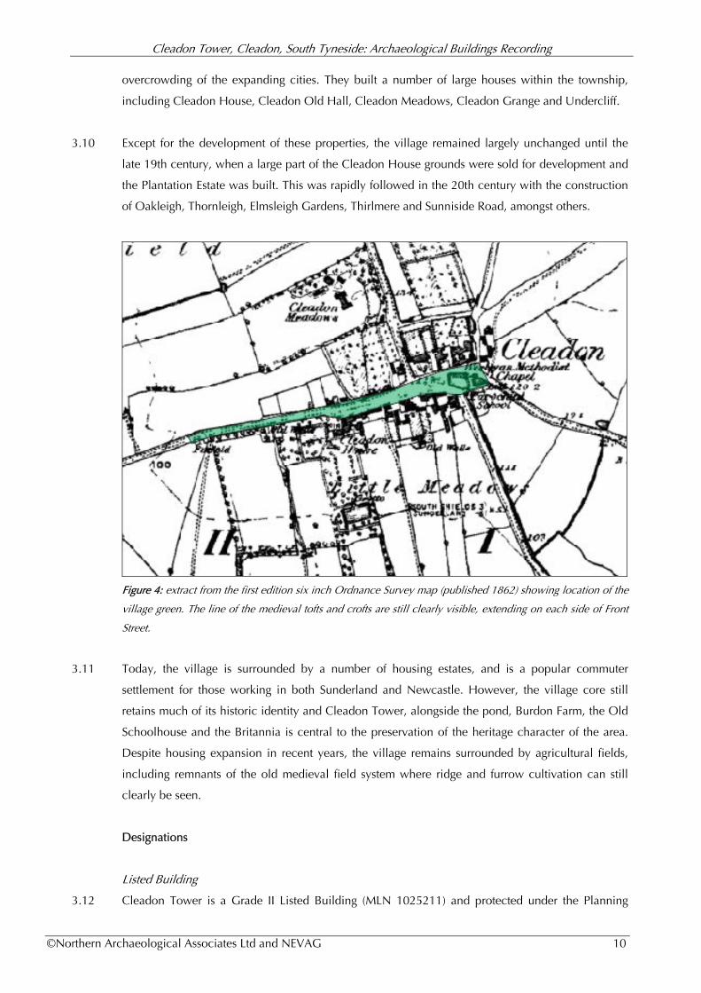
Figure 4: Extract from first edition six inch Ordnance Survey map (published 1862) showing location of the
village green.
Figure 5: Sale advertisement in Newcastle Courant , dated Saturday 20th January 1753.
Figure 6: Extract from Whitburn tithe map, prepared 1839 (DUSC DDR/EA/TTH/1/252).
Figure 7: Extract from the First Edition OS (1855), Cleadon Tower.
Figure 8: Sketch accompanying Scott’s 1891 article, looking west down Front Street. Cleadon Tower is
shown in the foreground , the tower - a little exaggerated in size, was rebuilt in 1890.
Figure 9: Extract from Sunderland Daily Echo and Shipping Gazette - Saturday 08 September 1894
Figure 10: Map regression showing development of property from 1839-1942
Figure 11: Plan of Cleadon Tower; ground floor (left) and first floor (right) plans.
Figure 12: South (above and east (below) elevations. Drawing by Martin Roberts (NEVAG)
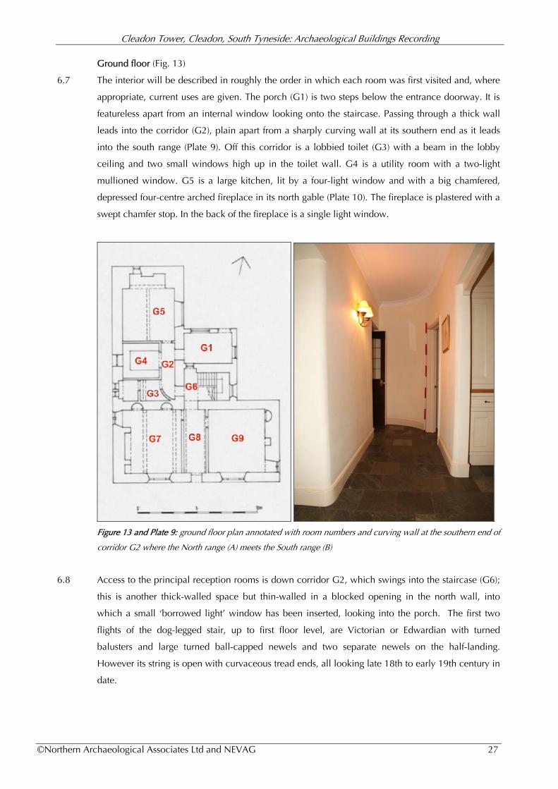
Figure 13: Ground floor plan annotated with room numbers
Figure 14: First floor plan annotated with room numbers
Figure 15: Attic Plan annotated with room numbers
Figure 16: Speculative layout of ground floor of 16th century property showing arrangement of key areas
Cleadon Tower, Cleadon, South Tyneside: Archaeological Buildings Recording
©Northern Archaeological Associates Ltd and NEVAG 4
CLEADON TOWER, CLEADON,
SOUTH TYNESIDE, TYNE AND WEAR
HISTORIC BUILDINGS RECORDING
1.0 INTRODUCTION
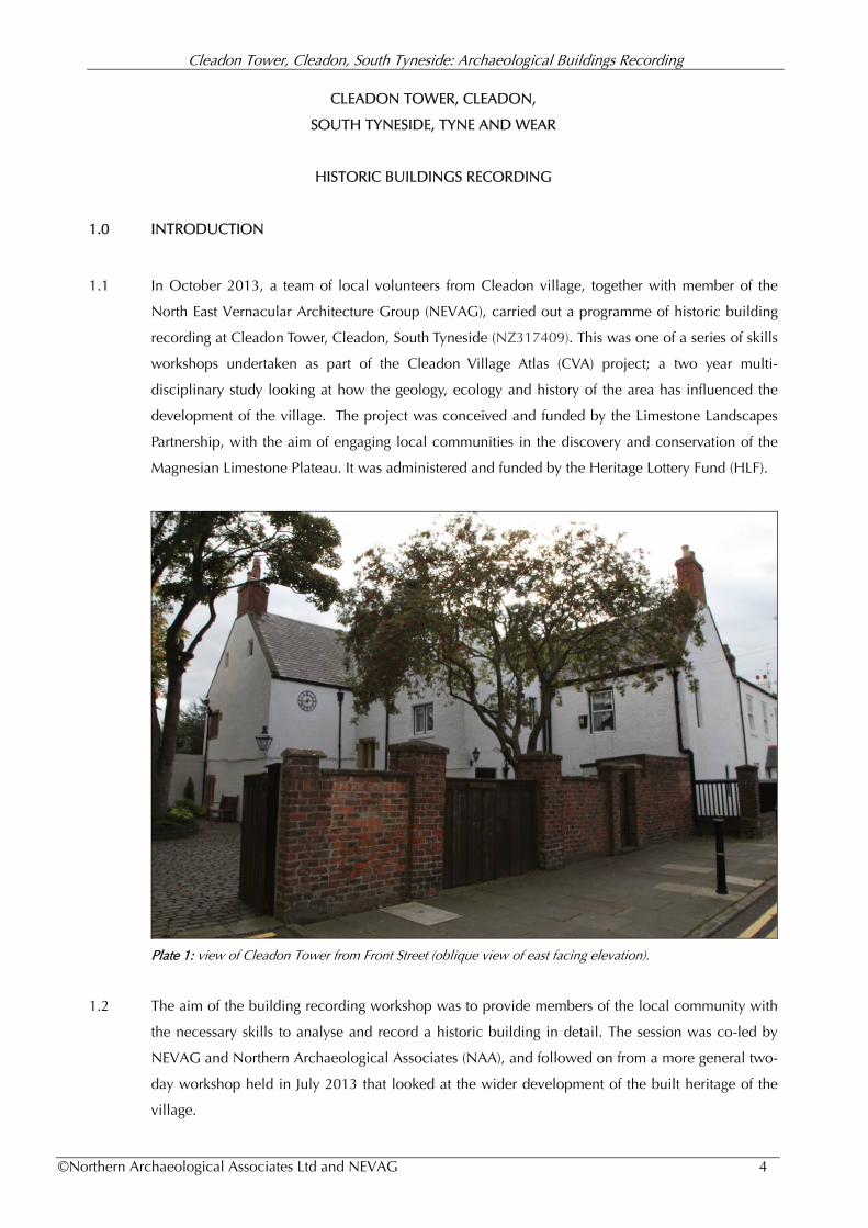
1.1 In October 2013, a team of local volunteers from Cleadon village, together with member of the
North East Vernacular Architecture Group (NEVAG), carried out a programme of historic building
recording at Cleadon Tower, Cleadon, South Tyneside (NZ317409). This was one of a series of skills
workshops undertaken as part of the Cleadon Village Atlas (CVA) project; a two year multi-
disciplinary study looking at how the geology, ecology and history of the area has influenced the
development of the village. The project was conceived and funded by the Limestone Landscapes
Partnership, with the aim of engaging local communities in the discovery and conservation of the
Magnesian Limestone Plateau. It was administered and funded by the Heritage Lottery Fund (HLF).
Plate 1: view of Cleadon Tower from Front Street (oblique view of east facing elevation).
1.2 The aim of the building recording workshop was to provide members of the local community with
the necessary skills to analyse and record a historic building in detail. The session was co-led by
NEVAG and Northern Archaeological Associates (NAA), and followed on from a more general two-
day workshop held in July 2013 that looked at the wider development of the built heritage of the
village.
Cleadon Tower, Cleadon, South Tyneside: Archaeological Buildings Recording
©Northern Archaeological Associates Ltd and NEVAG 5
1.3 The building survey was undertaken by kind permission of the owners of the property, Gavin and
Eileen Spencer, who provided full access to all areas of the building and additional documentary
material (deeds, covenants etc), not to mention welcome cups of tea and coffee.
Scope of work
1.4 The survey covered the whole building, but not the garden, out-buildings or boundary walls. It
comprised a Level 2/3 Historic England building survey: a 'descriptive' and analytical' study of the
property including a written, photographic and drawn record. All work was conducted in
accordance with current standards and guidance as published by English Heritage (now Historic
England) (2006a & 2006b) and the Chartered Institute for Archaeologists (CIfA) (2014).
Aims and objectives
1.5 The primary aim of the study was to provide members of the local community with the necessary
skills to undertake a historic building survey and to produce a comprehensive record of Cleadon
Tower.
This included the following objectives:
I. to provide guidance in looking analytically at a building, considering why it was built? How
did it develop? What was it built for? What was its original form? And who was associated
with it?
II. to provide training in elements of documentary research, photographing historic buildings,
drawing a measured plan, modern survey techniques (using a reflectorles total station) and
preparing a building report;
III. to introduce members of the local community to the work of NEVAG and provide a
framework for further recording work in the village in the future;
IV. to produce a Level 2/3 survey to act as a permanent record of Cleadon Tower;
V. to engage local people in the conservation of their built environment, and
VI. to have fun!
2.0 METHODOLOGY
Documentary evidence
2.1 A survey of all readily available documentary and cartographic material was made in order to
inform an understanding of the development and history of the property. As part of this work, the
following repositories were consulted:
Durham University Library Special Collections (DUSC)
Durham County Record Office (DRO)
Cleadon Tower, Cleadon, South Tyneside: Archaeological Buildings Recording
©Northern Archaeological Associates Ltd and NEVAG 6
The Tyne & Wear Archives at the Discovery Museum (TWA)
2.2 The following data sources were used:
historic cartographic sources (tithe maps and historic Ordnance Survey);
historic photographic archives;
primary documentary material, including census data;
ownership deeds and other documents;
trade directories;
published historical studies;
newspaper archives, and
various online sources
Building Recording
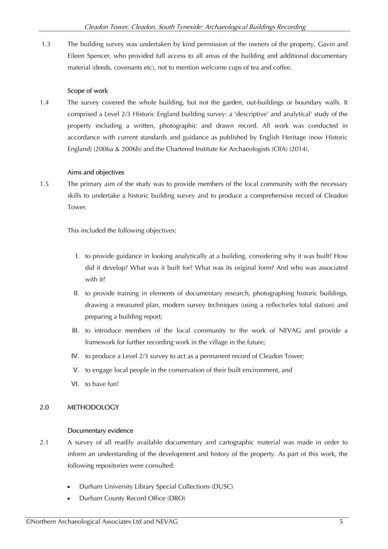
2.3 The building recording took place over a single day on Saturday 6th October 2013. It was attended
by seven people from Cleadon, together with members of NEVAG. The event was led by Martin
Roberts on behalf of NEVAG and Penny Middleton from NAA.
Plates 2 & 3: Carole Atkinson from Cleadon and Margaret Heald from NEVAG taking hand measurement in
preparation of the Cleadon Tower floor plans.
2.4 Floor plans and elevations were sketched and measured on-site by hand, with additional elevation
detail taken using a reflectorless total station theodolite. The measured sketches were subsequently
drawn-up by Martin Roberts of NEVAG. A digital photographic record was produced using a 14
megapixel digital camera. All elevation photographs were taken from vantage points as near
parallel as possible to the element being recorded. The internal photographic record included a
general view of each room (or discrete internal space) as well as detailed shots of significant
elements and representative examples of windows, doors and other fittings. A catalogue of all

Cleadon Tower, Cleadon, South Tyneside: Archaeological Buildings Recording
©Northern Archaeological Associates Ltd and NEVAG 7
images has been submitted to the Tyne & Wear Archives. Each photograph contained a graduated
photographic scale of suitable dimensions as well as a north arrow where appropriate.
3.0 BACKGROUND INFORMATION
Location
3.1 The village of Cleadon is located on the Sunderland to South Shields road (A1018) approximately 4
miles (6 km) north of Sunderland and 9 miles (14 km) south-east of Newcastle. Cleadon Tower is
situated within the historic core of the village, on the south side of Front Street (NZ 38444 62342);
approximately 0.5km from the A1018 junction (Fig. 2). The property sits back from the main road;
the northern edge of the plot marking the width of the former village green prior to the new road
layout implemented in the 1960s.
Figure 2: detailed location of Cleadon Tower (in red).
3.2 Cleadon Tower is believed to be the oldest building surviving in-situ in the village. It occupies a
linear plot, running north to south from Front Street. This almost certainly equates to one of the
original medieval land plots set out when the village was established, probably in the 12th or 13th
century. The width of the land holding, compared with others shown on 19th century maps of the
area, would suggest it always occupied a double plot.
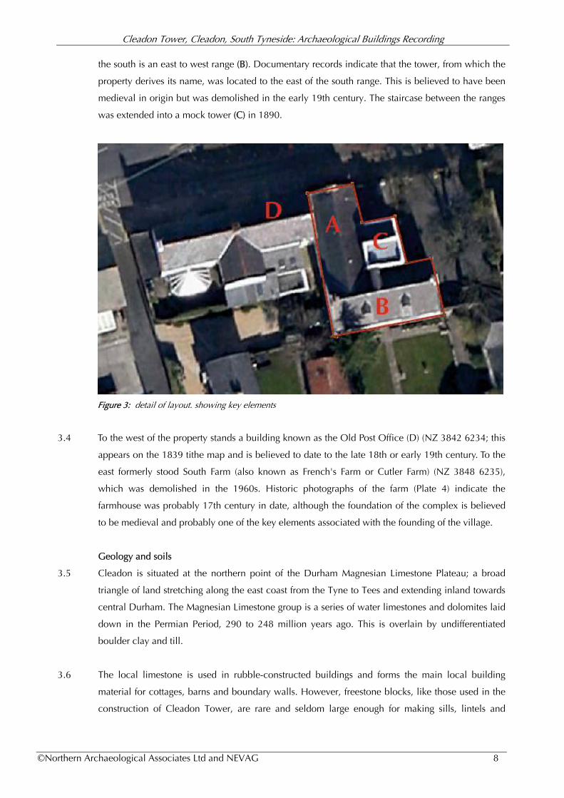
3.3 The present structure is an L-shaped building (Fig 3). The north range (A) is orientated north to south
along the western edge of the land plot, with the gable end facing onto the street. Adjoining this to
Cleadon Tower, Cleadon, South Tyneside: Archaeological Buildings Recording
©Northern Archaeological Associates Ltd and NEVAG 8
the south is an east to west range (B). Documentary records indicate that the tower, from which the
property derives its name, was located to the east of the south range. This is believed to have been
medieval in origin but was demolished in the early 19th century. The staircase between the ranges
was extended into a mock tower (C) in 1890.
Figure 3: detail of layout. showing key elements
3.4 To the west of the property stands a building known as the Old Post Office (D) (NZ 3842 6234; this
appears on the 1839 tithe map and is believed to date to the late 18th or early 19th century. To the
east formerly stood South Farm (also known as French's Farm or Cutler Farm) (NZ 3848 6235),
which was demolished in the 1960s. Historic photographs of the farm (Plate 4) indicate the
farmhouse was probably 17th century in date, although the foundation of the complex is believed
to be medieval and probably one of the key elements associated with the founding of the village.
Geology and soils
3.5 Cleadon is situated at the northern point of the Durham Magnesian Limestone Plateau; a broad
triangle of land stretching along the east coast from the Tyne to Tees and extending inland towards
central Durham. The Magnesian Limestone group is a series of water limestones and dolomites laid
down in the Permian Period, 290 to 248 million years ago. This is overlain by undifferentiated
boulder clay and till.
3.6 The local limestone is used in rubble-constructed buildings and forms the main local building
material for cottages, barns and boundary walls. However, freestone blocks, like those used in the
construction of Cleadon Tower, are rare and seldom large enough for making sills, lintels and
Cleadon Tower, Cleadon, South Tyneside: Archaeological Buildings Recording
©Northern Archaeological Associates Ltd and NEVAG 9
jambs etc. Sandstone for this purpose was imported into the village from elsewhere in the North
East (Cleadon Village Atlas 2015, 56-70).
3.7 By far the most common building material in the village is brick and there have been brickworks
associated with Cleadon at least since the 17th century, working the laminated clays of the Tyne-
Wear Complex and the Pelaw Clay (ibid).
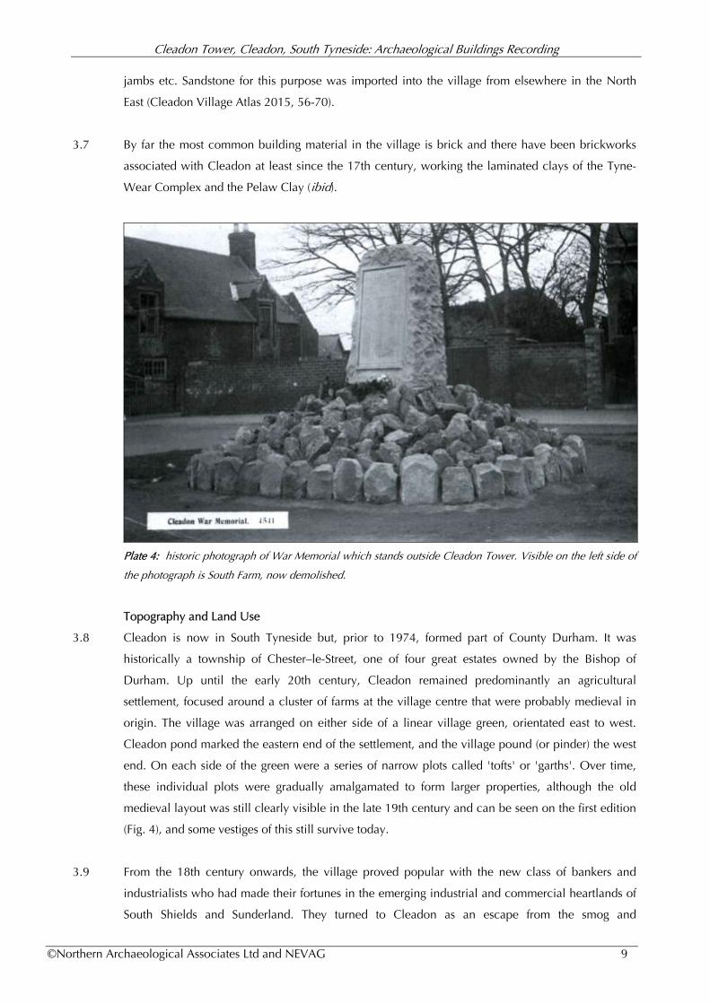
Plate 4: historic photograph of War Memorial which stands outside Cleadon Tower. Visible on the left side of
the photograph is South Farm, now demolished.
Topography and Land Use
3.8 Cleadon is now in South Tyneside but, prior to 1974, formed part of County Durham. It was
historically a township of Chester–le-Street, one of four great estates owned by the Bishop of
Durham. Up until the early 20th century, Cleadon remained predominantly an agricultural
settlement, focused around a cluster of farms at the village centre that were probably medieval in
origin. The village was arranged on either side of a linear village green, orientated east to west.
Cleadon pond marked the eastern end of the settlement, and the village pound (or pinder) the west
end. On each side of the green were a series of narrow plots called 'tofts' or 'garths'. Over time,
these individual plots were gradually amalgamated to form larger properties, although the old
medieval layout was still clearly visible in the late 19th century and can be seen on the first edition
(Fig. 4), and some vestiges of this still survive today.
3.9 From the 18th century onwards, the village proved popular with the new class of bankers and
industrialists who had made their fortunes in the emerging industrial and commercial heartlands of
South Shields and Sunderland. They turned to Cleadon as an escape from the smog and
Cleadon Tower, Cleadon, South Tyneside: Archaeological Buildings Recording
©Northern Archaeological Associates Ltd and NEVAG 10
overcrowding of the expanding cities. They built a number of large houses within the township,
including Cleadon House, Cleadon Old Hall, Cleadon Meadows, Cleadon Grange and Undercliff.
3.10 Except for the development of these properties, the village remained largely unchanged until the
late 19th century, when a large part of the Cleadon House grounds were sold for development and
the Plantation Estate was built. This was rapidly followed in the 20th century with the construction
of Oakleigh, Thornleigh, Elmsleigh Gardens, Thirlmere and Sunniside Road, amongst others.
Figure 4: extract from the first edition six inch Ordnance Survey map (published 1862) showing location of the
village green. The line of the medieval tofts and crofts are still clearly visible, extending on each side of Front
Street.
3.11 Today, the village is surrounded by a number of housing estates, and is a popular commuter
settlement for those working in both Sunderland and Newcastle. However, the village core still
retains much of its historic identity and Cleadon Tower, alongside the pond, Burdon Farm, the Old
Schoolhouse and the Britannia is central to the preservation of the heritage character of the area.
Despite housing expansion in recent years, the village remains surrounded by agricultural fields,
including remnants of the old medieval field system where ridge and furrow cultivation can still
clearly be seen.
Designations
Listed Building
3.12 Cleadon Tower is a Grade II Listed Building (MLN 1025211) and protected under the Planning
Cleadon Tower, Cleadon, South Tyneside: Archaeological Buildings Recording
©Northern Archaeological Associates Ltd and NEVAG 11
(Listed Buildings and Conservation Areas) Act 1990. It was first designated in 1949 and
subsequently updated in 1985 (Legacy No 303680).
3.13 A building may be listed for a number of reasons including its age, rarity, architectural merit, group
value, method of construction, and occasionally because it has an association with a famous
individual or event. They are graded according to their historic significance: Grade I buildings are
of national interest; Grade II* are particularly important buildings of more than special interest, and
Grade II are of special interest, warranting every effort to preserve them. Cleadon has no Grade 1
listed buildings but one Grade II* building (Cleadon House) and 16 Grade II Buildings.
Conservation Area
3.14 Cleadon Tower forms part of the Cleadon Conservation Area, designated in 1975 and later updated
in 2004 to include Cleadon Plantation. Cleadon Tower makes an important contribution to the
character of the historic core, even though much of the building is not visible from the street
frontage. Section 72 of the Planning (Listed Buildings and Conservation Areas) Act 1990 states that
special attention shall be paid to the desirability of preserving or enhancing the character or
appearance of Conservation Areas. Further details on the Conservation Area can be found in the
Conservation Area Character Appraisal prepared by South Tyneside District Council (2007).1
Previous work
3.15 No previous archaeological work has been undertaken at the property.
4.0 DOCUMENTARY SURVEY (Penny Middleton, NAA)
4.1 Cleadon Tower is believed to have been built for the Chambers family, one of the most important
and influential families in the parish of Whitburn. The ecclesiastical parish, which included the
townships of both Cleadon and Whitburn, first appears in the documentary record in the Boldon
Book, a list of all Bishop Puiset's (anglicised to Pudsey) estates, compiled in 1183. At this time,
Whitburn parish is listed as comprising 28 households, but there is no reference to a substantial
property associated with Cleadon, or specifically to the Chambers family. Similarly there is no
record of the property in the later Bishop Hatfield’s Survey of 1377-82 (Surtees Society 1820).
The Medieval Period
4.2 The Chambers family are thought to have originally hailed from Alnwick. Robert de la Chambre
was recorded as Escheator Royal of Northumberland in the early 14th Century. The Escheator was a
court official responsible for upholding the feudal rights of the Earl. In 1351 Robert’s son, John de
Chambers, became High Bailiff of Newcastle and throughout the 14th Century the name frequently
occurs in parish registers of the town and surrounding areas, often associated with the Christian
name John or Robert, suggesting familial links (Chambers 1906).
Cleadon Tower, Cleadon, South Tyneside: Archaeological Buildings Recording
©Northern Archaeological Associates Ltd and NEVAG 12
4.3 The first direct reference to the Chambers of Cleadon dates to 1509 when John Chambers is listed
as Collector for Cleadon in the Palatinate records (DUSC CCB B/23/5/91). The village collector, as
the name might suggest, was responsible for the collection of revenue and rents owed to the bishop
and required to present them regularly at the Halmote Court. This was a role of considerable status
and responsibility. It was also a fairly lucrative role, with plenty of opportunities to skim off a few
shillings here and there. As such, John would have been afforded the necessary rank and means to
construct the largest building in the village, but the construction of a fortified building was a
different matter altogether. This was a privilege which had to be granted by the bishop, and was
usually only issued to noblemen or at the very least freehold tenant, whereas all the land in
Cleadon was copyhold (belonging to the bishop).
4.4 However, there is some indication that Chambers may have had close connections with the Hylton
family, one of the leading noble families in the Palatinate during the medieval period. The Hylton's
were 'Barons of the Bishopric', a title held by a handful of knights who owed allegiance direct to
the Bishop, rather than the King. Amongst this group, the Hyltons were second only to the Prior of
Durham in importance, and certainly had the ear of the Bishop. The Hyltons held estates in both
Shilbottle and Durham until the late 14th century when the Northumberland lands were exchanged
with Henry Percy, the first Earl of Northumberland2. The Chambers are recorded as tenants of
Shillbottle in the 14th century and it is possible that a branch of the family moved south at the time
in the service of their manorial lord. There is evidence that the family were later in the baron's
service and a possible reference to a freehold manor in Whitburn parish belonging to the Hyltons
(Cleadon Village Atlas 2015, 107; Hutchinson 1783, 628). Was the tower built under the aegis of
the Hyltons? Is this perhaps the root of the popular myth that there is a tunnel leading from Cleadon
Tower to Hylton Castle? Given the distance between the two buildings this would be impossible
but the story could be a manifestation of an old ownership link between the two properties.
4.5 The date of construction of the tower remains uncertain. The reference to the freehold tenancy is
associated with William Hylton (1356–1435) who built Hylton Castle between 1398 and 1405, and
it is possible that Cleadon Tower was constructed around the same time. The first appearance of the
Tower in the documentary record is often given as 1587 (Surtees 1816, Warm ud) but this probably
refers to the Elizabethan Survey which records Richard Chambers as being the largest landholder in
the village, but does not make a specific reference to a hall or tower. Notably, there is also no
reference to a building in the will of John Chambers, yeoman dated 1575 (DPRI/1/1575/C1),
although the fact that it does not necessarily mention the Tower does not mean it was not in
existence by this period.
4.6 John left his goods to his son, Robert Chamber (of Cletonne), yeoman, who died a few years later in
1589 (DPRI/1/1589/C7). An inventory was made at the time of his death and it may be this which
1 citing online reference http://www.southtyneside.gov.uk/CHttpHandler.ashx?id=11677&p=0 2 citing online reference http://www.fusilier.co.uk/shilbottle_northumberland/history.htm
Cleadon Tower, Cleadon, South Tyneside: Archaeological Buildings Recording
©Northern Archaeological Associates Ltd and NEVAG 13
Surtees refers to, but sadly, this document has since been lost. It does, however, seem to suggest
that some form of hall would have been in existence at this time. In 1596, Chancery Court
proceedings were taken out by Edward Carleton of London against Robert's executor and heir,
Thomas Chambers for non payment of debt (PRO C 2/Eliz/C14/37 ) which might suggest that the
estate was in decline, possibly the result of the run of bad harvests and outbreaks of plague in the
area over the preceding century.
The 17th Century
4.7 Thomas Chambers prepared his own will in 1639, adding a codicil two years later in 1640. Again,
there is little in reference to a house at Cleadon, the emphasis being placed on a property in Pilgrim
Street, Newcastle, which he leaves to his son, Charles. Charles also receives ‘the rest of my goods,
moveable and immoveable’, which presumably included Cleadon Tower. The codicil does,
however, make a direct reference a house at Cleadon in relation to a gift to his daughter, Agnes
Farrow, of ‘a danske chist and the coffer that was her mother’s which I brought with me to
ffishborne forth of my bed chamber at Cleadon’ (Wood 1929, 281-3).
4.8 In 1620, Isabel Chambers of Cleadon had married George Lilburne at Whitburn church3. George
was the uncle of the famous radical, Freeborn John (1614-50), one of the leading figures in the
Leveller movement that advocated that each man held 'freeborn rights' not bestowed by any
government or human law. Although not as radical as his republican nephew, George Lilburn was
a Puritan and his marriage into the Chambers family must bring their religious allegiance into
question. This could account for their excommunication by Bishop Morton following a court
hearing on the 30th April 1637. On the surface this was supposedly a punishment for the Chambers
grinding grain at their own mill, as opposed to using the bishop’s mill at Whitburn. However such a
drastic measure, which at the time implied the eternal damnation of the soul, was a very extreme
punishment given the nature of the crime. Instead, the dispute may have been a vehicle used by the
Bishop to curb the power and influence of the Chambers family, and through them, George
Lilburne.
4.9 Tradition has it that following the excommunication members of the family were buried in the stack
yard to the North West of Cleadon Tower. In 1927 the skeletal remains of five adults were found in
the area during excavation of the gravel pits opposite Cleadon House. These were attributed to the
Chambers family but this was probably rather unlikely. There is a strong taboo against burying
human remains on or near a settlement dating back at least to the Roman period. Instead the bodies
may have been evidence of earlier settlement, perhaps Anglo-Saxon or before. Unfortunately we
have very few details about the burials, the bodies being re-interred in Whitburn church after
consultation with Miss Pollard the only surviving descendant of the Chambers family (Cleadon
Village Atlas 2014, 118).
3 citing Whitburn parish registers http://genuki.cs.ncl.ac.uk/Transcriptions/DUR/WBN.html

Cleadon Tower, Cleadon, South Tyneside: Archaeological Buildings Recording
©Northern Archaeological Associates Ltd and NEVAG 14
4.10 Lilburne and Isabel took up residence in a large house in Sunderland where George became one of
the most important figures in the development of the new town, and later a leading figure in the
Civil War, aiding the Scottish and Parliamentarian forces. After the war he continued to prosper, he
and his brother forming part of the County Committee responsible for seizing and reallocating land
belonging to the supporters of the King (Dodds 2013, 71). In the settlement he managed to procure
for himself a number of profitable estates, including parts of the Hylton Castle estate.
4.11 In May 1649, Richard Chambers, alongside Ralph Lumley, George Wake, John Bell and others,
witnessed the survey of church lands prepared in advance of the reallocation of the old Bishopric
estates into the administration of the new Dean and Chapter. The document lists the various
landholders in the mid 17th Century, as well as key communal resources including the windmill at
Whitburn (Kirby 1972, 43). Richard Chambers signed the document as one of the jurors of the
district. At this time, Elizabeth Chambers is listed as one of the largest landholders in the parish,
with extensive lands in Cleadon amounting to a copyhold rent of £12 9s 8d. This suggests that the
family did indeed share Lilburne’s parliamentarian loyalties and prospered handsomely during the
post-war period.
4.12 Elizabeth was the widow of Captain Robert Chambers, who may have died in the war. By Robert
she had a son, Thomas, and two daughters. Her connection with Richard Chambers, who signed
the 1649 survey, is not known, but there was another branch of the Chambers family living in
Whitburn, at Whitburn Hall. This can confuse the documentary sources, making it difficult to
interpret unless there is a direct reference to Cleadon.
4.13 Soon after the preparation of the 1649 survey, Elizabeth married Captain Thomas Gower, another
non-conformist and friend of Lilburne's, by whom she later had three sons - Richard, Thomas and
Robert (Wales et al 2004, 496). The inheritance of the Chambers estate appears to have been an
issue contested by various members of the family and in 1651, Thomas and Elizabeth Gower
entered Chancery Court proceedings against Charles Chambers over the copyhold of 'the manor of
Whitburn and Cleadon' (PRO C 5/21/46).
4.14 The Gowers appear to have won the case as in 1666, the Lady Day hearth tax returns for Cleadon
listing the largest property in the village as belonging to Thomas Gowre (Gower). This featured nine
hearths and was clearly the largest property in the village, the next largest had only three. This
building was almost certainly Cleadon Tower, the number of hearths concurring with the physical
evidence, observed during the buildings survey, suggesting a phase of considerable expansion
during mid to late 17th-century.
4.15 The 1676 Cleadon Enclosure agreement provides some indication of the size of the
Gower/Chambers landholding in the township at this time. It comprised 96 acres of land in the
North Field, a further 5 acres at Little Meadows, and 160 acres on Cleadon Lizard which was
Cleadon Tower, Cleadon, South Tyneside: Archaeological Buildings Recording
©Northern Archaeological Associates Ltd and NEVAG 15
'inherited from Robert Chambers' (DRO D/No1). On Elizabeth’s death, the Chambers estate was to
pass to her children and Mary Chambers, Robert Chambers' daughter by his marriage to his first
wife, Florence Horsely (Kirby 1972, 50).
4.16 Mary married Richard Blewhitt of Cleadon in 1650, by whom she had two sons, Robert and
William, and a daughter, Sarah. Richard died in 1658 and Mary remarried Thomas Wood, a major
Cleadon landholder in his own right. In 1668 she released her right to the Chambers estate to her
son Robert Blewitt (Surtees 1820). On his death it passed to his only daughter, Sarah, who had
married William Wilson. The other part of the estate had passed to Barbara Chambers, the only
surviving heir of Robert Chambers. She married Cuthbert Cotesworth and in June 1684 mortgaged
her share of the property to Sir John Duck for 1500/. The mortgage was subsequently foreclosed in
1700 for 1950/ and passed to Robert Sutton of Gateshead. Six years later, in April 1706, Sarah
Wilson also sold her holdings to Sutton for 1643/, uniting the two halves of the Chambers estate (op
cit).
The 18th Century
4.17 On the 28th Feb 1753, Robert Sutton's grandson (also called Robert) sold the whole 180 acre
estate, including Cleadon Tower, to William Wingfield for 2650l (op cit). The sale was advertised in
the Newcastle Courant on Saturday 20 January 1753 (Fig. 3). This provides the first description of
Cleadon Tower described as a 'Dwelling House', situated in the 'Town of Cleadon', containing
'seven fine rooms, and all hung with paper, or wainscotted, with a good Kitchen, Cellars,
Brewhouse, Stable, Coach-house, and Out-offices, all in good repair', and very good Gardens lately
planted with the best Fruit Trees'.
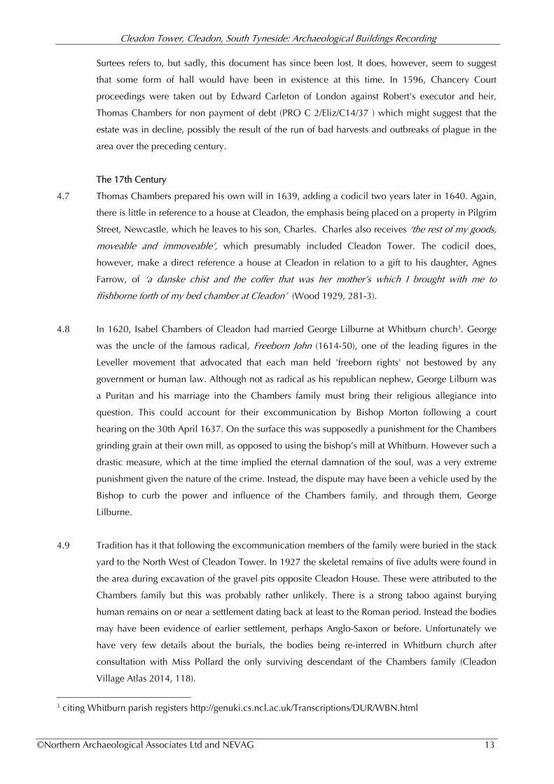
Figure 5: sale advertisement in Newcastle Courant dated Saturday 20th January 1753.
Cleadon Tower, Cleadon, South Tyneside: Archaeological Buildings Recording
©Northern Archaeological Associates Ltd and NEVAG 16
4.18 When William died in 1761, the property descended to his son, George, and on his death in 1774
to his son, also called George. He later took the name of Sparrow, in compliance with the will of
his great uncle, Richard Sparrow (Surtees 1820).
4.19 In 1787 Hutchinson refers to an ‘old tower’ at Cleadon, but confuses the ownership with Cleadon
House which would have been fairly new at the time, being built c. 1738. Cleadon House,
Cleadon Old Hall and Cleadon Tower are often confused in the documentary sources, which can
make interpretation difficult. Hutchinson describes the property as ‘an old tower at Cleadon,
commanding an extensive view’ (Hutchinson 1787, 629). This confirms that the tower is still
standing in the late 18th century.
4.20 In 1795 George Sparrow sold the estate to Richard Pemberton of Barnes for £2450 (Mackenzie &
Ross 1834, 64). It was on his acquisition of Cleadon Tower, or shortly after, that Pemberton took
down the old tower. Surtees, writing a few years later in 1820, records the building as:
‘a square tower of two stages, leaded, and with a spiral stone staircase to the top. It was attached to
the East end of the present old mansion, and commanded a very extensive prospect’ (Surtees 1820,
55).
4.21 Pemberton is listed as the landowner in the 1839 Whitburn tithe where Cleadon Tower (315) is
listed as a farm homestead, leased to George Bainbridge, the farmer at Bainbridge Farm, to the east
of Cleadon Tower (314). Notably, the north range (including the old kitchen) is shown as forming
part of a separate property running east to west along Front Street (probably the Old Post Office). It
is similarly shown on the 25 inch first edition OS map, published in 1855, (Fig 7) (218 & 219) but
by 1862, and the publication of the 6 inch first edition OS map, it is shown as part of a single
property. The tithe map also shows a small square building to the east of the south range, which
could be the surviving footprint of the old tower.
4.22 Pemberton is listed in the tithe apportionment book as owning the land to the west of Cleadon
Tower (314) and part of South Farm to the east (315), which included the L-shaped building shown
in Plate 4. Barbara Ormston owned the plot to the east of this (310), bordering the Sunderland to
Shields Road.
4.23 The Pemberton family retained ownership of the property for much of the first half of the 19th
century, their name appearing in the Dean & Chapter Estate records in 1856 (DUSC DHC 1/VI: Call
33). A year later, on the 29th January1857, the Pemberton Estate was purchased by Thomas Pollard
and the ship owner, John Young Gournley, who subsequently purchased the whole property. The
late 19th and early 20th century transactions are detailed in the property deeds, the 'Land and
hereditments known as Cleadon South Farm Estate, situated at Cleadon in County Durham', held by
the current owners, Mr and Mrs Spencer.
Cleadon Tower, Cleadon, South Tyneside: Archaeological Buildings Recording
©Northern Archaeological Associates Ltd and NEVAG 17
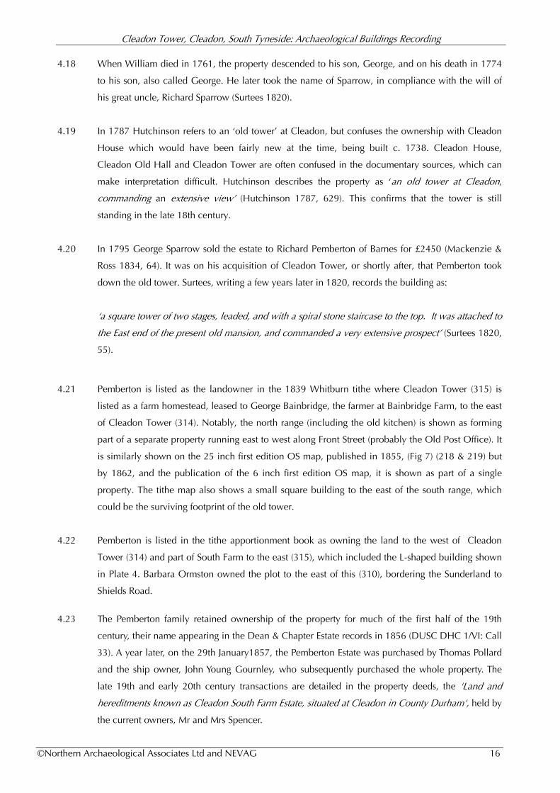
Figure 6: extract from Whitburn tithe map, prepared 1839 (DUSC DDR/EA/TTH/1/252).
Reproduced by permission of Durham University Library.
Figure 7: extract from the First Edition OS (1855), Cleadon Tower.
Cleadon Tower, Cleadon, South Tyneside: Archaeological Buildings Recording
©Northern Archaeological Associates Ltd and NEVAG 18
4.24 Published in 1885, the 25 inch first edition Ordinance Survey (OS) (Fig. 7) provides the first detailed
and fairly accurate illustration of the property layout (218/219), including the associated out-
buildings. The earlier staircase tower is shown connected to both ranges, this was extended in 1890
(there is a date plate above door at roof level) to form the ‘tower’ which is such a marked feature of
the building today. To the east of the property (222) the agricultural buildings associated South Farm
can be clearly seen. These include two horse-engines - or gin-gangs - located in the semi-circular
buildings attached to two of the barns. These would have been used to drive threshing machines
and fodder cutters.
4.25 An article on the Chambers family, written by one of their descendants, Captain B. M. Chambers, in
1906, includes a description of Cleadon Tower, by Jonothan [sic] Oldbuck. This is undated but is
referenced as being written 'some years since' and, therefore probably dated to the latter half of the
19th century, before the new faux tower was built. The extract reads:
"I have called it a hall it was originally a tower; the pity is so little is left . . . such an old building is
regarded as a quarry of hewn stone . . . But enough remains to show the solidity ... of Cleadon Hall.
There is a kitchen with a single stone ten feet in width above the fireplace, now, alas! no longer an
ingle nook. There are walls five and six feet thick; stone and wood enough to build a whole street
for a Sunderland building society. In one room there was, within living memory, a trap-door in the
floor with a subterranean passage into the fields, some of which passage still remains in the next
house. Not unlikely this was made to serve as a cott-hole for a priest ... In one of the rooms there is
a very fine stone carving in perfect preservation of the arms of the Chambers family. This is about
the date of the reign of King James the first. Few families not noble had a better attested antiquity
than that of Chambers, of which I believe Sir Thomas Chambers, the Recorder of London, is the
present head. . . ."
4.26 This description would suggest that the property had fallen into some disrepair towards the end of
the 19th century. By 1882 the house was leased to George Pollard and his family (Sunderland Daily
Echo and Shipping Gazette Wednesday 15 February 1882). George Pollard hailed originally from
Newcastle, marrying a descendant of the Chambers family (Summers 1858, 227). It was probably
him who set about repairing the old property, perhaps in respect of his wife's familial links with the
house. He almost certainly built the new tower, described and sketched by Scott (Fig. 8) in an
article on Cleadon published in 1891:
'Cleadon does not materially differ from the ordinary country village. There are the usual low
cottages with red-tiled roofs, then larger dwellings, many of which are made picturesque and bright
by trim gardens…The imposing structure on the left is part of a farmer's residence known as
Cleadon Towers. Although its architecture is suggestive of medieval times, it was only erected in
the March of 1890'.
Cleadon Tower, Cleadon, South Tyneside: Archaeological Buildings Recording
©Northern Archaeological Associates Ltd and NEVAG 19
4.27 Pollard was born in Newcastle, later moving to Egglescliffe and Castle Eden, before settling in
Cleadon. He is listed in 1891 census as a 'gentleman of independent means', aged 45. Others in
the household recorded at the time were his wife Isabella (46); his daughters Eleanor (20), Sarah
(19), Olivia (15), Rosa(13), Isabella (12), Florence (10), and Lydia (8); his sons George (17), John
(14) and Thomas (5); his mother-in-law, Eleanor Stephenson (88); a governess, Mary Hordon (26),
and domestic servant, Susan Lenie (30) (PRO RG12-4163 - Folio: 10, 13 South Shields).
4.28 The Pollards were an important local family, George holding the position of chairman of the Parish
Council for a number of years, and laying the foundation stone for the construction of the new
school in 1902 (Sunderland Echo, 17th Nov 1902), by which date the family had moved to the
newly built Cleadon Grange. Their son, Major George Pollard (b. 1874) was a decorated army
officer, who had joined the 1st Royal Newcastle Engineers (Volunteers) in 1899 and fought as a
lieutenant in the South African Campaign in 1901. George and Isabella commissioned three stained
glass windows in the chancel of All Saints church, designed by the Scottish artist James-Eadie Reid,
in commemoration of the safe return of their son from the South African Campaign, 1900-01
(Cleadon Village Atlas 2014, 184).
Figure 8: sketch accompanying Scott’s 1891 article, looking west down Front Street. Cleadon Tower is shown
in the foreground. The tower – shown a little exaggerated in size - was rebuilt in 1890.
4.29 In 1894, the property was again put up for sale, following the death of John Young Gourney
(Sunderland Daily Echo and Shipping Gazette - Saturday 08 September 1894). Lot 4 of the sale,
which took place at the Newcastle County Hotel on the 19th September, was described as 'The
family mansion known as "Tower House" (Fig. 9), occupied by George Pollard and comprising a
drawing room, dining room, 5 bedrooms, 2 attics, kitchen, large pantry and coal house. Lot 5 of the
sale was the adjoining property, which is now known as The Old Post Office.
Cleadon Tower, Cleadon, South Tyneside: Archaeological Buildings Recording
©Northern Archaeological Associates Ltd and NEVAG 20
4.30 It would seem that the property was not purchased at this time but passed instead to Sir Edward
Temperley Gourney, John's son. Born in 1826, he had served an apprenticeship as a coalfitter with
Halcro, one of the largest commercial businesses then in Sunderland. Under the supervision of John
Halcro, Gourley became a successful businessman, starting up as a shipowner in his own right
(Sunderland Daily Echo April 1902). He was joined in this venture by his father and his uncle,
Edward Temperley, expanding the business to include coal timber export. He later developed an
interest in politics, and was the Member of Parliament for Sunderland from 1868 to 1900.4
Figure 9: extract from Sunderland Daily Echo and Shipping Gazette - Saturday 08 September 1894
4.31 Gourney did not live at Cleadon Tower. By 1896, the Pollards had moved out of the property and it
was leased to W. H Blake (marriage announcement - London Standard - 07 September 1896) who
remained there till c.1900 (Sunderland Daily Echo and Shipping Gazette - Friday 24 August 1900).
On Gourney's death in 1902, his niece, Dora and her husband, George Elliot Coxton, a colliery
agent, were living in Cleadon Tower (Deeds). Sir Edward left the property to Dora, Jospeh Harold
Lumsden, William Brown and John Harold Gourney (ibid).
4.32 In October 1905 Cleadon Tower, was sold to Dominique Wawm for £1,150. The particulars of the
sale documents provide some details on the house interior:
'All cornices, poles and blinds. Picture rods in the dining and breakfast rooms. Oil cloth in the
entrance hall and back entrance. Cocoa mat in kitchen. Stove in entrance hall. Pegs in hall and
bathroom and gas fittings.'
And outside
'...two wooden trellis arches, one espalier, two garden seats, one summerhouse with cushions and
valances, all flowers and fruit bushes, greenhouse complete with shelves, water tank, twelve hour
stove and most of the plants, wire netting, hose and real (sic) in garden. Three oak water butts, one
4 citing online reference http://ghgraham.org/edwardtemperleygourley1826.html [accessed 23/08/15).

Cleadon Tower, Cleadon, South Tyneside: Archaeological Buildings Recording
©Northern Archaeological Associates Ltd and NEVAG 21
swing complete in side garden, flagstaff and vane in lower, one grass cutter, electric bells, step
ladder leading up to tower' (Deeds 1905).
4.33 Wawm was an engineer and a keen local historian. He subsequently wrote a history of the village
(undated) which included a description of Cleadon Tower. This was illustrated with sketches of key
features of the house interior. He and his wife, Nora Patricia Wawm, donated the marble and oak
font at All Saints Church, in memory of their daughter, who had died at a young age.
Plate 5: Dominique Wawm (far left) and his brothers (left to right) Tom, Frederick and Edgar Allan taken c.
1914. Photo kindly provided by Carmen Higgs.
4.34 Wawm died c.1956, the house then passing to Margaret Brigham (Deeds 1957). The Brighams were
ship builders, one half of Brighams and Cowan Ltd, one of the largest yards in South Shields, later
becoming part of British Shipbuilders in 1977. The yard finally closed in 1982. The Brighams
‘restored’ much of the interior of the old house. In 1969 an article in the Sunderland Echo refers to
the refitting of a fireplace with Dutch tiles and, unfortunately, the removal of the old panelling and
wainscoting ‘which was much decayed’. The ‘old hall which looked out onto the terrace’ was said
at the time to exhibit some fine ‘early Georgian timber’ (Sunderland Echo - 1st May 1969).
4.35 The current owners, Eileen and Gavin Spencer, purchase the property in 1980.

Cleadon Tower, Cleadon, South Tyneside: Archaeological Buildings Recording
©Northern Archaeological Associates Ltd and NEVAG 22
5.0 THE CLEADON TOWER TIME LINE
1509 First mention of John Chambers, collector for Cleadon. Mid 17th century falls to female
line. Estate divided.
1587 Surtees dates this as the first mention of the tower in the documentary records (Surtees
1820, 55) but it is unclear where this reference comes from but probably the Elizabethan
Survey of that year which records Richard Chambers as the largest landholder in the
township but does not make a specific reference to a hall or tower .
1589 Robert Chambers of Cleadon dies and leaves a will and inventory but, sadly, the latter has
since been lost. However, this does suggest that a hall of some form was in existence in the
village at this time.
1596 Edward Carleton of London against Robert's executor and heir, Thomas Chambers for non
payment of debt.
1620 Isabel Chambers of Cleadon married George Lilburne, later mayor of Sunderland and
prominent figure on the Parliamentarian side during the Civil War.
1637 30th April 1637 - case brought against Thomas Chambers by Bishop Morton for not
grinding corn at the bishop's mill. Chambers family are excommunicated.
1639 Will of Thomas Chambers prepared but no direct reference to a hall or tower but codicil
written in 1640 does mention a gift to his daughter, Agnes Farrow, of ‘a danske chist and
the coffer that was her mother’s which I brought with me to fishborne forth of my bed
chamber at Cleadon’
1649 Richard Chambers was one of the witnesses to the reallocation of the old Bishopric estates
by the new Dean and Chapter. Elizabeth Chambers is mentioned in the survey as the
widow of Captain Robert Chambers. She soon after marries Captain Thomas Gower.
1651 Thomas and Elizabeth Gower entered Chancery Court proceedings against Charles
Chambers over the copyhold of 'the manor of Whitburn and Cleadon'
1666 Thomas and Elizabeth Gower mentioned in the Cleadon Hearth Tax returns as owning a
property with nine hearths. This was almost certainly Cleadon Tower and is the first direct
evidence of the property.
1676 Cleadon Enclosure Agreement - Gowers (Chambers) recorded as sizeable landowners.
c. 1680 Cleadon estate passed to the surviving children of Robert Chambers.
1700 -1706 Much of the estate sold to Robert Sutton of Gateshead over this period.
1753 28th February - Robert Sutton, grandson of Robert, sold the whole estate, including
Cleadon Tower to William Wingfield. A sale notice in the Newcastle Courant describes the
property as containing 'seven fine rooms, and all hung with paper, or wainscotted, with a
good Kitchen, Cellars, Brewhouse, Stable, Coach-house, and Out-offices, all in good
repair', and very good Gardens lately planted with the best Fruit Trees'.
1774 Property passes to William's grandson, George, who takes the name George Sparrow.
1787 Hutchinson writes his famous history of Durham, in which describes the property as ‘an
old tower at Cleadon, demanding extensive views' (Hutchinson 1787, 629)

Cleadon Tower, Cleadon, South Tyneside: Archaeological Buildings Recording
©Northern Archaeological Associates Ltd and NEVAG 23
1795 George Sparrow sells the estate to Richard Pemberton of Barnes for £2450. Soon after
Pemberton demolishes the tower.
1839 First cartographic representation of the property appearing in the 1839 Whitburn tithe map.
1857 29th January - Pemberton Estate purchased by Thomas Pollard and the ship owner, John
Young Gournley. Gournley later purchased the whole estate.
1882 Cleadon Tower leased to George Pollard. Pollard still living in the building in 1891 and
appears in the census data along with his large family.
1894 Property put up for sale and described as 'The family mansion known as "Tower House".
Property not sold but passed to Sir Edward Temperley Gourney, John Gourney's son.
1896 Property leased to W.H. Blake
1902 Gourney's niece, Dora, and her husband, George Elliot Coxton, living at the property.
1905 Sold to Dominque Wawm for £1,150.
1927 The skeletal remains of five adults were found in the area during excavation of the gravel
pits opposite Cleadon House.
1957 House sold to the Brighams, one half of Brighams and Cowan Ltd, one of the largest
shipyards in South Shields.
1980 House sold to the current owners, Eileen and Gavin Spencer.
6.0 BUILDING DESCRIPTION (Martin Roberts, NEVAG)
Exterior
5.1 The L-shaped house has two ranges set at right angles to each other (Fig 11). Each range is two
storeys high (including attics) with a steeply pitched roof. In the angle between the two is a three-
storey staircase tower with adjoining two-storey porch. The principal south range is set back from
the village frontage, overlooking gardens to the south. Only the gable of the slightly narrower
northern service range has a street frontage. The whole building is rendered and the main ranges
roofed in Welsh slates with stone gable parapets and engineering brick stacks. The stair tower and
entrance porch are flat-roofed with crenellated parapets.
6.2 The south elevation comprises a symmetrical three-bay front, with a central door flanked by
windows on both floors, and two dormers in the roof (Fig 12 and Plate 7). The central stone
doorcase appears to be of Victorian or Edwardian date with a depressed four-centred door head. It
features a panelled door with glazed lights, probably of the same date. Above it, on the first floor,
just off-centre, is a small two light timber window, set deeply back in slightly splayed reveals. The
windows in the flanking bays are all slightly different from one another. All except the first floor
oriel window in the third (eastern) bay have deep reveals, and a tripartite design; the lights divided
by deeply returned timber mullions.
6.3 The ground floor windows have sufficient height to incorporate a transom with top lights, the
western window with a thin transom, the eastern window with a transom as deep as the mullions.

Cleadon Tower, Cleadon, South Tyneside: Archaeological Buildings Recording
©Northern Archaeological Associates Ltd and NEVAG 24
The first floor western window is shorter than that below on the ground floor and so lacks the
transom and top lights. The first floor eastern window is a slightly projecting oriel, supported on
brackets, with three panels beneath the tripartite mullioned and transomed windows. The roof
dormers are sashed with decorative bargeboards to their gables. All the windows, except the oriel,
sit under dropped hoodmoulds. These, along with all the window joinery on this elevation, look to
be 19th or early 20th twentieth century; the same date as the doorcase.
Figure 11: plan of Cleadon Tower; ground floor (left) and first floor (right) plans. Drawing by Martin Roberts
(NEVAG)
6.4 The east elevation comprises the gable and rear (north) wall of the south range, the stair tower and
porch, and the east side wall of the north range (Fig 12). The east gable of the south range has a
two-light mullioned stone window on each floor, set beside the chimney stack (Plate 7). These are
19th or early 20th century in date and have a greater depth than authentic mullioned windows. In
the gable are two small single light windows. The rear (north) wall of the south range is featureless.
The three-storey stair-tower and two-storey porch have a mixture of stone (stair) and timber (porch)
two-light mullioned windows (Plate 8). The stair tower rises up to roof ridge height, with a short
pitched roofed corridor extending into the attic. The arched-headed entrance doorway, with
battened door, is on the north wall of the porch, facing the village street. The east wall of the north
range has a wide four-light timber ground floor window to the kitchen, with a narrower sash above.
6.5 The north gable is plain apart from a single light window on each floor, beside the central stack.
Cleadon Tower, Cleadon, South Tyneside: Archaeological Buildings Recording
©Northern Archaeological Associates Ltd and NEVAG 25
Figure 12: south (above and east (below) elevations. Drawing by Martin Roberts (NEVAG)
6.6 The west side of Range A abuts the neighbouring property on the village frontage (The Old Post
Office). The southern part (Range B) is the only section which remains exposed. At ground floor
level this features two, two-light stone mullioned windows, renewed but of the correct proportions
to be accurate replacements, i.e. their sills have not been dropped. There are also two small square
lights. On the first floor is another two-light stone mullioned window and a larger single-light
window, perhaps once sashed but now of two unequal lights divide by a timber transom. All have
leaded glass. The timber work and stone work of the windows looks to be of 19th or early 20th
century date, but no doubt replacing original features.

Cleadon Tower, Cleadon, South Tyneside: Archaeological Buildings Recording
©Northern Archaeological Associates Ltd and NEVAG 26
Plates 6 to 8: south elevation showing pattern of fenestration on this side of the building, and the main door,
probably 19th or early 20th century in date. East facing elevation - gable of south range (lower left) and the
stair case tower (lower right) built 1890, though possibly incorporating earlier material.
Interior
Cleadon Tower, Cleadon, South Tyneside: Archaeological Buildings Recording
©Northern Archaeological Associates Ltd and NEVAG 27
Ground floor (Fig. 13)
6.7 The interior will be described in roughly the order in which each room was first visited and, where
appropriate, current uses are given. The porch (G1) is two steps below the entrance doorway. It is
featureless apart from an internal window looking onto the staircase. Passing through a thick wall
leads into the corridor (G2), plain apart from a sharply curving wall at its southern end as it leads
into the south range (Plate 9). Off this corridor is a lobbied toilet (G3) with a beam in the lobby
ceiling and two small windows high up in the toilet wall. G4 is a utility room with a two-light
mullioned window. G5 is a large kitchen, lit by a four-light window and with a big chamfered,
depressed four-centre arched fireplace in its north gable (Plate 10). The fireplace is plastered with a
swept chamfer stop. In the back of the fireplace is a single light window.
Figure 13 and Plate 9: ground floor plan annotated with room numbers and curving wall at the southern end of
corridor G2 where the North range (A) meets the South range (B)
6.8 Access to the principal reception rooms is down corridor G2, which swings into the staircase (G6);
this is another thick-walled space but thin-walled in a blocked opening in the north wall, into
which a small ‘borrowed light’ window has been inserted, looking into the porch. The first two
flights of the dog-legged stair, up to first floor level, are Victorian or Edwardian with turned
balusters and large turned ball-capped newels and two separate newels on the half-landing.
However its string is open with curvaceous tread ends, all looking late 18th to early 19th century in
date.
Cleadon Tower, Cleadon, South Tyneside: Archaeological Buildings Recording
©Northern Archaeological Associates Ltd and NEVAG 28
Plate 10: four centred arched fireplace in G5 (former kitchen); notice swept chamfered stops on each side.
Plate 11: first two flights of staircase are Victorian of Edwardian with turned balusters and ball-capped newels.
6.9 The western room in the south range is the dining room (G7), entered through a two-panel door
with fine moulded architrave; all of early-mid 18th century appearance but possibly renewed. The
Cleadon Tower, Cleadon, South Tyneside: Archaeological Buildings Recording
©Northern Archaeological Associates Ltd and NEVAG 29
ceiling features two oak beams, both supported on corbels at each end; the corbel in the north wall
is painted with a ‘B’, probably for 'Brighams'.
6.10 The room has simple curved cornice moulding. There is a large stone fireplace in the gable wall.
This has a broad chamfer with a depressed four-centred arch, its chamfer stop heavily worn, but
looking like a simple straight stop. The fireplace is framed in a dark-stained surround and closed off
behind the fireplace reveals; the blocking wall is faced with Delft tilework (Plate 14). On the south
side of the fireplace is an alcove set with a wainscoted door; this also appears to be Edwardian and
of the same date as the fireplace surround, although the latch and butterfly hinge may have come
from something earlier. On the north side of the fireplace is a two-light mullioned window. The
fireplace itself appears to be original, and of a similar date to that in G5.
Plate 12: fireplace in G7, the fireback closed off and set with Delft tilework
6.11 In the north wall of G7 are set two plain semicircular alcoves with half-domed heads, their frames
with curved edges. In the south wall is a large window with deep splayed reveals. The room has a
stone-flagged floor.
Cleadon Tower, Cleadon, South Tyneside: Archaeological Buildings Recording
©Northern Archaeological Associates Ltd and NEVAG 30
Plates 13 & 14: alcove to the south of the fireplace. The door looks Edwardian in date but may be set with
earlier (17th century?) fittings.
Plate 15: fireplace and neo-classical domed recess in the main reception room (G9).
Cleadon Tower, Cleadon, South Tyneside: Archaeological Buildings Recording
©Northern Archaeological Associates Ltd and NEVAG 31
Plates 16 & 17: Cleadon Tower fireplaces c. 1900 - the drawing room (G9) (left) and dining room (G7) (right)
from an article in the Sunderland Echo article published in 1969.
6.12 The entrance hall (G8) is plain with a stone-flagged floor and two plastered beams in the ceiling.
To the east of the hall, the drawing room (G9) is the principal reception room and features a
reproduction late-18th century neo-classical fire surround. The 1969 Sunderland Echo article
features a photograph (Plate 16) of an earlier, deep-set four-centred arched stone fireplace in this
location. It is difficult to determine the date of this feature based on the photograph but the
moulding seems very crisp and it is likely to be early 20th century in date. North of the fireplace is
a semicircular arched china alcove with fluted pilasters and shaped keystone. This features wavy-
edged shelving and surprisingly rich carved mouldings and dentilled cornice. It seems to be 18th
century in date, although the decoration may have been enhanced at a later. However, it is not
shown in the 1969 photograph and, therefore, must have been either relocated from elsewhere in
the building or salvaged from another property. South of the fireplace, is a deep high plain recess,
lit by a mullioned window.
6.13 In the south wall is a large window with deep splayed reveals. The plain flat ceiling has a simple
curved cornice moulding.
First Floor (Fig. 14)
6.14 The ground floor staircase, described above, becomes particularly interesting at first floor level and
above (F1). The north wall of the staircase is thinner than on the ground floor, consequently the first
flight, which rises to the attic bedrooms, is much wider and the walls here are lined with dark dado
panelling. At the half landing is a shelf on the east wall, disguising the transition between the

Cleadon Tower, Cleadon, South Tyneside: Archaeological Buildings Recording
©Northern Archaeological Associates Ltd and NEVAG 32
thickness of the walls below and thinner walls above. Furthermore, the design of the staircase
changes in the flight above first floor, where the roughly square-section handrail of the lower two
flights gives way to a round-section handrail, sweeping continuously round the half-landing and
supported by a mixture of plain stick balusters and turned balusters, of the same design as in the
lower flight (Plate 18). The string detail on the staircase is as on the ground floor flights. All this
suggests that the majority of the surviving staircase dates to the late 18th century, but that the
ground floor flights have had their balustrading renewed completely, c.1900. Consequently, in an
effort to blend the two phases together, the surviving upper flights have had alternate stick balusters
replaced.
Figure 14 & 18: first floor plan and the sweeping handrail and mixed turned and stick balusters at first floor
level (and above).
6.15 The principal bedroom (F3) occupies the eastern half of the south range. It features a spayed single
light and oriel window in the south wall and two-light mullioned window in east gable. The ceiling
is plain, except for a single plastered beam. There is a simple curved cornice around the walls and
high moulded skirting. A key feature of the room is a high quality late 18th century fireplace in
patterned marble. The main surround is edged in a bay leaf band, the supporting pillars set back
with carved bearded heads, Greek key banding top and leaf and dart base. A similar moulding is
used to edge the lintel, with its central carved roundel of a lady (hiding her face) having her feet
washed. The source of the fireplace is not known but it was probably installed in the house as part
of the refurbishments undertaken by Brigham in the mid 20th century.

Cleadon Tower, Cleadon, South Tyneside: Archaeological Buildings Recording
©Northern Archaeological Associates Ltd and NEVAG 33
6.16 The second bedroom in the south range (F4) is situated to the west and features a casement and
side-sashed main window with a two-light mullioned window in the west gable. There is a shallow
plastered beam downstand in the ceiling. The entrance door is two panelled and set within a
bolection-moulded doorframe with a heavily moulded raised panel above, all possibly c.1700,
although the door may have been renewed.
Plates 19 & 20: the impressive marble fireplace in the main bedroom (F3) and two panelled door leading into
(F4); possibly early 18th century in date.
6.17 A short corridor (F5) provides access between the two south range bedrooms and into the north
range. A two-panelled door, set in a bolcetion-moulded frame with panel over the door, provides
leads through into a third bedroom (F6). The layout of rooms in this part of the house seems to
indicate that the passageway has been in existence since at least c.1700. Bedroom (F6) has a small
stone fireplace set in the south wall. This features a cranked-headed fireplace with a richly moulded
surround and ogee stops, all framed to two tapering fluted pilasters, with heavily moulded plinth
and cornice, although supporting nothing. Above the mantel are the arms of the Chamber family: a
chevron (red) between three cinquefoils with an indecipherable symbol or compounded lettering
above; this may be a merchant's mark. Both shield and crest are surmounted by a black (sable)
muzzled and collared bear passant. The device was first recorded in 1634 (Burke 1864, 182). It was
later restored to Sir Robert Chambers, Chief of Bengal, who in the late 19th century claimed
decadence from the Cleadon Chambers. Above the heraldry is a richly moulded cornice with three

Cleadon Tower, Cleadon, South Tyneside: Archaeological Buildings Recording
©Northern Archaeological Associates Ltd and NEVAG 34
shallow projections, not extending across the full with of the fireplace, nor are its projections
sufficient to be lamp brackets.
Plates 21 & 22: splendid fireplace - and detail of coat of arms - in the north range bedroom (F6)
6.18 The fourth bedroom (F7) is situated at the far end of the North range, overlooking the street
frontage. The most immediately striking feature of the room is the thickness of the north wall,
measuring nearly 2.00m thick. A relatively modern deep-set splay window has been set into this to
provide additional light into the interior. The width of the wall creates a narrow arched recess as
well as a deep set cupboard in the north-western corner. There is an elegant arched display stand in
the east wall which may be 18th century, but looks to be reproduction.
The Attic (Fig. 15)
6.19 There are two rooms at attic level, both with boxed-in timbers so it is not possible to determine the
date of the trusses. Potentially they are relatively late, having been replaced when the building was
extensively restored in the early 20th century.
6.20 The roof is A-framed, with collared principal rafters; the collar set quite high up near the apex to
provide for maximum living space. In the South range (A1) there are two small, crudely shaped,
windows cut into the gable on each side of western stack. There is also a small window let into the
east gable, as well as the two attic dormers. A rather elegant gothic revival wooden door leads from
the south range attic (A1) to the North (A2). There were no windows in the North range attic; the
area today is lit by modern skylights.

Cleadon Tower, Cleadon, South Tyneside: Archaeological Buildings Recording
©Northern Archaeological Associates Ltd and NEVAG 35
Figure 15: attic plan annotated with room numbers
Plate 23: south range attic space, looking west, with gable windows clearly visible.
Cleadon Tower, Cleadon, South Tyneside: Archaeological Buildings Recording
©Northern Archaeological Associates Ltd and NEVAG 36
The Tunnels
6.21 There is a tradition in the village that there are tunnels running from Cleadon Tower. Some believe
these run to Hylton Castle, while others have claimed that they run to Monkwearmouth but given
the distance of both of these sites this is extremely unlikely, however, there may perhaps a grain of
true in these tales. There was a tunnel, accessed from the floor of present kitchen (G5), which ran
across the road to the Britannia but was filled in when the weight of traffic on the road became a
safety issue (Gavin Spencer. pers. comm.). This was said to lead to farm buildings were the
Chambers family were caught grinding their own corn, but this is unlikely, given that at the time
this would have been the Matthews House - formerly located where the Britannia Inn now stands.
There is a second passageway in the cellar of the Old Post Office, and references to workmen in
the mid 20th century following the course of this for some distance. Unfortunately, it is not possibly
to determine what this feature might be as the entrance is now blocked. However, it may possibly
be a drain associated with the medieval building; medieval drains are known to be often quite
substantial in size.
7.0 DISCUSSION OF THE BUILDINGS DEVELOPMENT (Roberts & Middleton)
Phase One: Medieval
7.1 There appears to be no surviving above ground evidence of a medieval tower at Cleadon, although
there could well be sub-surface archaeological remains associated with the structure. A tower of
some antiquity did stand on the site until the late 18th century, demolished by Christopher
Pemberton in 1795. It is referred to by both Surtees and Hutchinson, who recall the building in
living memory. Surtees describes a two floored tower with and a stone spiral staircase. Such a
feature could indicate a medieval date but even in the late 16th century stone newels were still
being built in the county, for example in 1592 at Unthank Hall, Stanhope. Surtees also notes that
Mr Abbs of Cleadon House believed that the tower was ‘merely a fanciful building for pleasure, to
enjoy the view’ (1820). However, such belvedere towers were very much an 18th century, rather
than a medieval, concept and, given the obvious age of the structure in the early 19th century, this
would seem highly unlikely.
7.2 It is probable, therefore, that the tower was built as a solar tower; a defensible building of private
apartments. Solar towers such as this were not constructed as independent, self-sufficient properties
but usually added to an existing house. In the case of Cleadon, this was probably an undefended
medieval manor house of the usual hall and cross wing(s) form. This would almost certainly have
been situated to the west of the tower, on the site of the present property. However, while the walls
of the existing building are very thick they are not substantial enough to indicate the survival of
any in-situ medieval fabric; although some fragments of earlier fabric could have been incorporated
into the later build. Within County Durham, similar solar towers are known from Ludworth
(licensed 1422), and the rectories at Houghton-le-Spring Rectory (1483), Redmarshall and
Gainford. There are also numerous examples in Northumberland, the proximity of the Scottish

Cleadon Tower, Cleadon, South Tyneside: Archaeological Buildings Recording
©Northern Archaeological Associates Ltd and NEVAG 37
border seeing a fortified tradition persist much longer than in Durham.
7.3 It is unusual, but by no means unknown, that a fortified property would be constructed on the
Bishops land without a licence to crenellate. In fact only eight licences were ever issued by
Durham's bishops, including 3 pardons and a retrospective grant. By the early 15th century, the
granting of a licence was no longer a means to curb the military power of the local barons but was,
instead, an opportunity for the bishop to raise revenue. Notably, there is also no licence to fortify
associated with nearby Hylton castle, constructed for William Hylton in the late 14th to early 15th
century. The connection between Sir William and the Chambers family has already been noted and
it may be that Cleadon Tower was constructed at around the same time.
Phase Two: 16th Century
7.4 Taking the hypothesis of a medieval manor house with an added solar tower, the present building
on the site can be seen as the complete rebuilding of the earlier manor house. This might have
represented the replacement of an earlier timber structure in stone. The 'new' house comprised the
two stone-walled ranges extant today: a south hall and chamber range and, at right angles to it, a
north service wing. It is possible that originally the house may have been of courtyard form with an
entry north and a (now missing) outer service range to the east, abutting the tower. For circulation
to the upper floors, the logical position for a staircase in such a configuration would be at the angle
of the two buildings. The thickness of the walls in both ranges, measuring between 700-800mm
thick, together with that of the lower half of the staircase, suggests a single phase of build in the mid
to late 16th century. At this time the south range may have been divided into a hall (west) and
parlour (east), with a door opening in the south-east corner of the parlour (and another on the first
floor) giving access to the solar tower (Fig. 16).
Figures 16 & 17: speculative layout of ground floor of 16th century property showing arrangement of key
areas and drawing of the fireplace and coat of arms in (G5).

Cleadon Tower, Cleadon, South Tyneside: Archaeological Buildings Recording
©Northern Archaeological Associates Ltd and NEVAG 38
7.5 As such, if the present kitchen (G5) can be said to be the original 16th century kitchen, then the
rooms at the southern end of the north range(now occupied by rooms G3 and G4) would be the
buttery and/or pantry, abutting the main hall. Significantly there is no evidence of a fireplace in this
area of the building. It is tempting to see the two alcoves in the north wall of the dining room (the
hall in the 16th century house) as former door openings, the westernmost leading into the small
unheated service rooms, the other into a passage through to the kitchen and staircase (Plate 25).
The original entry into the house was perhaps through the north wall of the staircase, then right into
the passage and then so into the hall.
7.6 The broad-chamfered fireplaces in the kitchen (G5) and dining room (G7) could be original to this
phase of development. The stone fireplace in the drawing room (G9), photographed in the early
20th century, before it was concealed by the existing classical one, appears to be a later
replacement and either a faithful replication of a damaged original, or a product of the owner’s
imagination.
Plate 24: Blencowe Hall in Cumbria, a hall and earlier solar tower (expanded in the 17th century).; although a
smaller complex, Cleadon Tower may looked similar and developed in the same way
Phase Three: 17th Century
7.7 The columned fireplace in the upper chamber (G6) would suggest a phase of remodelling in the
mid to late 17th century. By 1640, and the outbreak of the Civil War, the Chambers family had
obviously consolidated their position to become one of the leading families in the area, ranking
alongside the minor aristocracy. Something of their status in early 17th century society is evident
from the assumption of the Chambers coat of arms in 1634 and the marriage of George Lilburn, a
prominent statements (if a commoner) to Elizabeth Chambers.
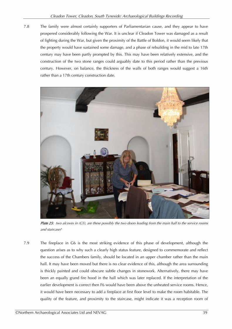
Cleadon Tower, Cleadon, South Tyneside: Archaeological Buildings Recording
©Northern Archaeological Associates Ltd and NEVAG 39
7.8 The family were almost certainly supporters of Parliamentarian cause, and they appear to have
prospered considerably following the War. It is unclear if Cleadon Tower was damaged as a result
of fighting during the War, but given the proximity of the Battle of Boldon, it would seem likely that
the property would have sustained some damage, and a phase of rebuilding in the mid to late 17th
century may have been partly prompted by this. This may have been relatively extensive, and the
construction of the two stone ranges could arguably date to this period rather than the previous
century. However, on balance, the thickness of the walls of both ranges would suggest a 16th
rather than a 17th century construction date.
Plate 25: two alcoves in (G5), are these possibly the two doors leading from the main hall to the service rooms
and staircase?
7.9 The fireplace in G6 is the most striking evidence of this phase of development, although the
question arises as to why such a clearly high status feature, designed to commemorate and reflect
the success of the Chambers family, should be located in an upper chamber rather than the main
hall. It may have been moved but there is no clear evidence of this, although the area surrounding
is thickly painted and could obscure subtle changes in stonework. Alternatively, there may have
been an equally grand fire hood in the hall which was later replaced. If the interpretation of the
earlier development is correct then F6 would have been above the unheated service rooms. Hence,
it would have been necessary to add a fireplace at first floor level to make the room habitable. The
quality of the feature, and proximity to the staircase, might indicate it was a reception room of
Cleadon Tower, Cleadon, South Tyneside: Archaeological Buildings Recording
©Northern Archaeological Associates Ltd and NEVAG 40
some form, where Sir Robert entertained private guests away from the more public space of the
hall. Arguably, the solar tower may have seemed a more fitting location for such a room but this
may have already been falling into decay by this period or been damage following the Civil War.
7.10 The largest property recorded in the 1666 hearth tax features nine stacks and was almost certainly
the Chamber's house. There is evidence of six, or maybe seven hearths, in the property currently: 1
x kitchen (G5); 2 x hall (G7-G9); 1 main chamber (F3); second chamber (F4); columned fireplace
(F6), and probably one at the north end of (F7) (although this area may have been heated by the
kitchen below). This assumes two or possibly three fireplaces in the original tower (since
demolished). By the 17th century, this number of hearths (and hence chimneys) would have been a
clear sign of wealth and would have marked out the Chambers family as the most important
residents of the village.
7.11 Other features possibly associated with this phase of development are the two first floor panelled,
bolcetion-moulded doors leading into chambers G5 and G6. These are typical of a late 17th, very
early 18th century date.
Phase Four: 18th and early 19th centuries
7.12 During this period a number of features may have been added to the property in keeping with
increasing popularity of classical design, prevalent by the early 18th century. The alcove and
fireplace in the drawing room (G9) and the fireplace in the main first floor bedroom (F3) possibly all
date to this period. The alcove may be in-situ, or has perhaps been moved. The 18th century saw
the continued transition away from the multi-functional space of the hall and the foundation of a
more refined, personal space for the family. The fireplace in F3 is 18th century in date but may
have been introduced to the property as late as the early to mid 20th century, either by Wawm or
Brigham.
7.13 At the end of this period, c. 1795, the solar tower was demolished. This would have certainly had a
dramatic impact on both the layout of the building and possibly its structural integrity. There was,
therefore, probably an associated phase of consolidation and improvement.
Phase Five: late 19th and early 20th centuries
7.14 In the latter half of the 19th century a further phase of development saw the construction of the
mock 'tower' by extending the staircase up into the attic. Similarly, the attic space itself was
probably converted at this time to provide additional servant accommodation. Significantly there is
no indication of it being originally used as a gallery as at Gainford Hall (1603) and at Middridge
Grange (1578). Previously, the space was possibly used for storage (including grain and foodstuff),
drying and curing meats. Before the Victorian period, servants were more integrated within the
household, living in the main house or possibly in the village, but by the end of the century the
household was more deeply stratified with a range of domestic staff living in-house. However, in
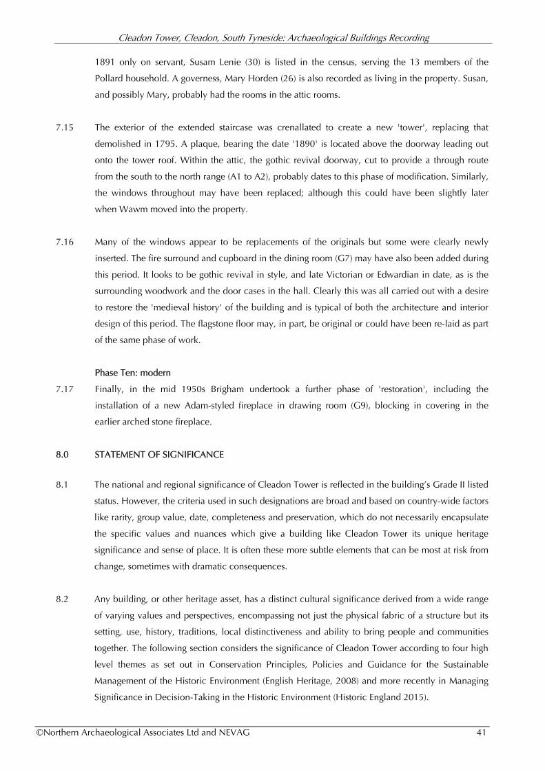
Cleadon Tower, Cleadon, South Tyneside: Archaeological Buildings Recording
©Northern Archaeological Associates Ltd and NEVAG 41
1891 only on servant, Susam Lenie (30) is listed in the census, serving the 13 members of the
Pollard household. A governess, Mary Horden (26) is also recorded as living in the property. Susan,
and possibly Mary, probably had the rooms in the attic rooms.
7.15 The exterior of the extended staircase was crenallated to create a new 'tower', replacing that
demolished in 1795. A plaque, bearing the date '1890' is located above the doorway leading out
onto the tower roof. Within the attic, the gothic revival doorway, cut to provide a through route
from the south to the north range (A1 to A2), probably dates to this phase of modification. Similarly,
the windows throughout may have been replaced; although this could have been slightly later
when Wawm moved into the property.
7.16 Many of the windows appear to be replacements of the originals but some were clearly newly
inserted. The fire surround and cupboard in the dining room (G7) may have also been added during
this period. It looks to be gothic revival in style, and late Victorian or Edwardian in date, as is the
surrounding woodwork and the door cases in the hall. Clearly this was all carried out with a desire
to restore the 'medieval history' of the building and is typical of both the architecture and interior
design of this period. The flagstone floor may, in part, be original or could have been re-laid as part
of the same phase of work.
Phase Ten: modern
7.17 Finally, in the mid 1950s Brigham undertook a further phase of 'restoration', including the
installation of a new Adam-styled fireplace in drawing room (G9), blocking in covering in the
earlier arched stone fireplace.
8.0 STATEMENT OF SIGNIFICANCE
8.1 The national and regional significance of Cleadon Tower is reflected in the building’s Grade II listed
status. However, the criteria used in such designations are broad and based on country-wide factors
like rarity, group value, date, completeness and preservation, which do not necessarily encapsulate
the specific values and nuances which give a building like Cleadon Tower its unique heritage
significance and sense of place. It is often these more subtle elements that can be most at risk from
change, sometimes with dramatic consequences.
8.2 Any building, or other heritage asset, has a distinct cultural significance derived from a wide range
of varying values and perspectives, encompassing not just the physical fabric of a structure but its
setting, use, history, traditions, local distinctiveness and ability to bring people and communities
together. The following section considers the significance of Cleadon Tower according to four high
level themes as set out in Conservation Principles, Policies and Guidance for the Sustainable
Management of the Historic Environment (English Heritage, 2008) and more recently in Managing
Significance in Decision-Taking in the Historic Environment (Historic England 2015).

Cleadon Tower, Cleadon, South Tyneside: Archaeological Buildings Recording
©Northern Archaeological Associates Ltd and NEVAG 42
Evidential Values - the potential capacity of the property to advance further research and
provide a better understanding of past human activity;
Historical Values - the potential of the property to inform the historic narrative and to forge a
connection between the present and the past through association with people, events and
aspects of life;
Aesthetic Values - the potential for people to derive sensory and intellectual stimulation from
the property, through design, art, character and setting;
Community Values - the potential for Cleadon Tower to bring people and communities
together; to relate to a collective experience or memory.
Overall Significance
8.3 Cleadon Tower is considered to be of considerable (local/regional) significance in terms of its
evidential, historic and aesthetic values. Evidentially, while there appears to be no remaining
above-ground evidence of the original medieval tower fragments of the earlier building could be
incorporate into the fabric of the current property. In addition, there is considerable potential for
the survival of sub-surface archaeological remains associated with the structure. There are a
number of what would appear to be fragments of medieval masonry in the garden, although the
provenance of these is unknown. However, they could be part of an earlier complex.
8.4 Despite the absence of any standing evidence, the tower is of exceptional historic significance in
terms of understanding the development and social structure of the immediate area, and the wider
Palatinate as a whole. The Chambers appears to have had important connections with the Hyltons,
one of the most powerful families during the medieval period and members of the so-called Barons
of the Bishopric, instrumental in the early administration of the bishopric. Further study of the
history of the family might inform a greater understanding of the local yeomanry (if indeed this is
what the Chambers were) and their role within the political and economic matrix of mid to late
medieval Durham.
8.5 Similarly, the property is of considerable importance in terms of our understanding of the 17th
century, in particular the impact of the Civil War. There is considerable evidence to suggest that the
existing house was constructed either in the late 16th or early 17th century, and is one of the few
buildings dating to this period surviving in the region. Given the historic connections with George
Lilburne, and the proximity of the Battle of Boldon, there a possibility that further information on
this period of the house's history could come to light through archaeological investigations and
further documentary research.
8.6 The splendid coat-of-arms fireplace in (F6) is perhaps one of the most important elements in the
whole property. It is not only of considerable historic value as a signifier of the success and status of
the Chambers family by the 17th century but also of intrinsic architectural and aesthetic merit in its
own right, and a good example of Jacobean or Carolingian heraldry. The enigmatic symbol above

Cleadon Tower, Cleadon, South Tyneside: Archaeological Buildings Recording
©Northern Archaeological Associates Ltd and NEVAG 43
the Chambers coat-of-arms may be a merchant mark, possibly a cloth merchant’s guild insignia.
Similar symbols can be found carved onto the late 15th century font of St Mary’s Church, Barnard
Castle (Gary Banblead pers. com.).
8.7 Other elements of architectural and evidential value include the kitchen range (G5); the fireplace in
(G7); the late 17th or early 18th century doors on the first floor (F4 and F6); the staircase; wall stops
(G8) and decorated 18th century alcove in the drawing room (F9). The 18th century marble
fireplace on the second floor is also of some significance, although inserted into the house
relatively recently. Similarly the arts and craft, or Gothic Revival pieces (including the dining room
fireplace surround, panelling and doorcases in the hall) are also of some significance as excellent
examples of the form and of considerable aesthetic value for the contribution they make to the
overall character of the property.
8.8 In terms of the exterior, the south facing elevation is of exceptional value as the primary facade of
the building. In particular, the pattern of the fenestration is important. Although the windows have
been extensively replaced, they probably reflect the original form and style, with some obvious
exceptions. Similarly, the south facing door is an early 20th century replacement of an earlier
feature but contributes to the overall style and character of the property. The fact that this elevation
appears to be the main facade would perhaps suggest a more formal approach to the house in the
16th or 17th century, possibly with a formal garden and walkways. There may be fragments of
surviving above ground evidence of this but no direct documentary references have as yet come to
light. It is likely that a property of the size and importance of Cleadon Tower would have had
gardens given the known importance of those at nearby Cleadon House and Cleadon Old Hall,
both built in the 18th century. However, it is possible that by this stage the status of Cleadon Tower
was already in decline.
8.9 The main public view of the house today is looking south-west, towards the north and east facing
elevation. This view is somewhat shielded from public gaze by the boundary wall but it is,
nevertheless, an important factor in the setting of the property, and an key component of the
Conservation Area. Also of significance in this regard is the immediate curtilage of the house,
which clearly reflects the dimensions of the original burgage plot (it is in fact a double plot). The
layout of the house, with the narrow north to south wing (north range) set gable end to the road,
and the east to west hall-block (south range), set back from what was the village green but running
parallel to it (Fig. 4). It is possible that the original 16th century house was of courtyard form with
an entrance to the north leading to the village and additional service buildings in an eastern range,
now missing. The house may have been set out like this to optimise the position available in the
medieval (or immediately post-medieval) village and seems to predate the layout of the other
properties within the historic core, like Burdon Farm, which follow the line of the road. This would
suggest that Cleadon Tower is probably the oldest property standing in the village. As such, it
makes a valuable contribution not only to the visual setting and historic character of the village
Cleadon Tower, Cleadon, South Tyneside: Archaeological Buildings Recording
©Northern Archaeological Associates Ltd and NEVAG 44
core but also to our understanding of the form, foundation, and subsequent development of the
settlement as a whole.
8.9 Finally, the various tales and stories associated with the property, as well as its prominent position
in the centre of the village, make of the site of some communal value. The story of the
excommunicated Chambers family, and their supposed disinterment in the early 20th century, as
well as the tunnel leading to Hylton Castle, all form key elements in Cleadon folklore. It is these
stories that help to keep village tradition alive, no matter whether they are true or not. Similarly, the
concept of a medieval 'tower' at the heart of Cleadon (even though it is often confused with the
pumping station campanile), gives local people a strong sense of history and the continuity with the
past; a factor becoming increasingly more important in an age of rapid development and change.
9.0 FURTHER RECOMMENDATION
9.1 There is undoubtedly further documentary material surviving in the various local archives related to
the history of the Chambers family, their land, and possibly the development of Cleadon Tower.
The Bishop estate records, housed at Durham University Special Collections, which would
certainly benefit from a more detailed study; in particular, a closer look at the relationship between
the Chambers of Cleadon and those of nearby Whitburn. Such work can be time consuming and
was beyond the capacity of this report, but could make an interesting and worthwhile project for
anyone with an interest in local history. The National Archive at Kew also seems to hold some
useful documents. These can be searched (and potentially ordered) online at
http://www.nationalarchives.gov.uk/
9.2 While the Spencers may justifiably recoil in horror from the idea of digging up their beautiful
garden, archaeological investigation, especially of the area to the east of the house, would be
highly recommended in order to inform the existence, extent, nature, preservation, and possibly the
date of any archaeological evidence associated with the early development of the property and
village. This would not need to necessarily be anything large but could be a small trial trench,
although 'keyhole' archaeology on a very small a scale should be avoided as it frequently returns
very limited results and might damage the integrity of deposits for future investigation.
9.3 Separate from any targeted research investigations, the high potential for the preservation of
archaeological remains associated with the site mean that any sub-surface intervention, like the
installation of new services, construction of extensions or other ancillary buildings in the vicinity of
the property are likely to require an archaeological watching brief at the very minimum. All
changes to the interior and exterior of the building (and potentially elements within the curtilage)
are obviously subject to listed building consent according to the 1990 Listed Buildings and
Conservation Areas Act.

Cleadon Tower, Cleadon, South Tyneside: Archaeological Buildings Recording
©Northern Archaeological Associates Ltd and NEVAG 45
REFERENCES
Burke, B (1864) The General Armory of England, Scotland, Ireland, and Wales: Comprising & Registry of
Armorial Bearings from the Earliest to the Present Time
Chambers, B.M (1906) ‘Notes on the family of Chambers of Cleadon and Whitburn, Co. Durham’ in Northern
Notes and Queries devoted to the Antiquities of Northumberland, Cumberland, Westmorland, and
Durham. Vol 1, No.1-8, 239-242 Jan. 1906-Oct.1907"
CIfA (2014) Standard and guidance for the archaeological investigation and recording of standing buildings or
structures
Dodds, G. L (2013) A History of Sunderland.
English Heritage (2008a) Management of Research Projects in the Historic Environment (MoRPHE): PPN6:
development of Procedural standards and guidelines for the historic environment
English Heritage (2008b) Conservation Principles, Policies and Guidance for the Sustainable Management
English Heritage (2006a) Understanding Historic Buildings: A Guide to Good Practice
English Heritage (2000) Metric Survey Specifications for English Heritage
English Heritage (1999) The Presentation of Historic Building Survey in CAD
Fordyce, W. (1855) The History and Antiquities of the County Palatinate of Durham, vol.2
Greenwell, W (1852) Boldon Book, Surtees Society, 25, p. 46
Greenwell, W (1856) Bishop Hatfield's Survey, Surtees Society, 32, pp. 102-06
Historic England (2015) Managing Significance in Decision-Taking in the Historic Environment.
Historic Environment Good Practice Advice in Planning Note 2
Hutchinson, W. (1787) The History and Antiquities of the County Palatine of Durham
Kirby, D.A. (1972) Parliamentary Surveys of the Bishopric of Durham, Surtees Society, II 185, pp. 49-52
Latimer, W (1857) Local Records or Historical register of remarkable Events, which have occurred in
Northumberland and Durham, Newcastle-up-Tyne, and Berwick-upon-Tweed 1832-57
Liddy, C.D (2008) The Bishopric of Durham in the Late Middle Ages
Mackenzie & Dent (1825) An Historical, Topographical, and Descriptive View of the County of
Northumberland, and of Those Parts of the County of Durham Situated North of the River Tyne,
with Berwick Upon Tweed, and Brief Notices of Celebrated Places on the Scottish Border.
Mackenzie, E and Ross, M (1834) An historical, topographical, and descriptive view of the County Palatine of
Durham. Vol I and II
Morris, J (1982) The Boldon Book: History from Source ed. John Morris
NAA (2014) The Cleadon Village Atlas Report. Rpt No. 01-15
Petts, D & Gerrad, C (2006) Shared Visions: The North-East Regional Research Framework for the
Historic Environment
Pevsner, N. and Williamson, E (1990) The Buildings of England: County Durham
Roberts, B.K (1977) The Green Villages of County Durham
Roberts, B.K (2008) Landscape, Documents and Maps: Villages in Northern England and beyond AD
900-1250
Scott, W (1891) The Monthly Chronicle of North-Country Lore and Legend
Cleadon Tower, Cleadon, South Tyneside: Archaeological Buildings Recording
©Northern Archaeological Associates Ltd and NEVAG 46
STC (2007) Cleadon Conservation Area Character Appraisal
STL (1994) Pictures of Cleadon: A Look Back in Time. South Tyneside Libraries
Summers, J.W (1858) The History and Antiquities of Sunderland
Surtees, R. (1816) The History and Antiquities of the County Palatine of Durham: Vol II
Surtees Society (1857) Bishop Hatfield’s Survey, 32, 102-106
Wood (1929) Durham Wills and Inventories, Part IV, Surtees Society, 142, 281-3.
Wales, T.C; Hartley, C. P.; Holden, J. L. O. & Drewry Squibb, G (2004) The Publications of the Harleian
Society 2004
Map References:
1839 Whitburn Parish Tithe (DUSC DDR/EA/TTH/1/252)
1855 25-inch first edition Ordnance Survey Map VIII.1, VIII.2, IV.14
1862 6-inch first edition Ordnance Survey Map Durham VIII & IV
1895 25-inch second edition Ordnance Survey Map VIII.1, VIII.2, IV.14
1898 6-inch second edition Ordnance Survey Map Durham VIII & IV
1919 6-inch third edition Ordnance Survey Map Durham
1939 6-inch fourth edition Ordnance Survey Map Durham
Archive Records:
Durham University Special Collections
DUSC CCB B/23/5/91 Reference to John Chambers as collector for Cleadon
DUSC DDR/EA/TTH/1/252) Whitburn tithe map
DUSC DHC 1/VI: Call 33 Dean & Chapter Estate Records
DPRI/1/1575/C1 Will of John Chambers of Cleadon
DPRI/1/1589/C7 Will of Robert Chamber (of Cletonne), yeoman
Durham Record Office
DRO D/No1 Cleadon Enclosure agreement
Public Record Office (Kew)
PRO C 2/Eliz/C14/37 Edward Carleton of London against Robert's executor and heir, Thomas Chambers for
non payment of debt
PRO C 5/21/46 Thomas and Elizabeth Gower Chancery Court proceedings against Charles Chambers over
the copyhold of 'the manor of Whitburn and Cleadon'
PRO RG12-4163 1891 Census data Folio: 10, 13 South Shield