clean water fund targeted watershed demonstration program
TRANSCRIPT
Clean Water Fund Targeted Watershed Demonstration Program
Report to the Legislature
January 15, 2016
This document is made available electronically by the Minnesota Legislative Reference Library as part of an ongoing digital archiving project. http://www.leg.state.mn.us/lrl/lrl.asp
BWSR 2015 Targeted Watershed Demonstration Program Report
Minnesota Board of Water & Soil Resources • www.bwsr.state.mn.us
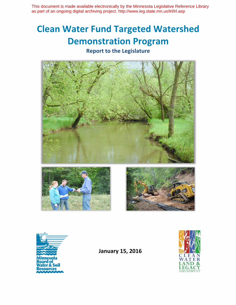
Pictured on the front cover: Top: Dobbins Creek near Austin, Minnesota. Bottom left: Chisago SWCD staff meet with BWSR staff. Bottom right: Construction underway above the Poplar River.
This reports meets the legislative requirements found in Minnesota Session Laws 2013 Chapter 137 Article 2 Section 7 (a) which reads: By January 15, 2016, the board shall submit an interim report on the outcomes achieved with this appropriation, including recommendations, to the chairs and ranking minority members of the senates and house of representatives committees and divisions with jurisdiction over environment and natural resources policy and finance.
Prepared by Celi Haga and Marcey Westrick. The estimated cost of preparing this report (as required by Minn.
Stat. 3.197) was:
Total staff time: $1,880 Production/duplication: $25 Total: $2,005 BWSR is reducing printing and mailing costs by using the Internet to distribute reports and information to wider audiences. This report is available at www.bwsr.state.mn.us/cleanwaterfund and available in alternative formats upon request.
Minnesota Board of Water and Soil Resources 520 Lafayette Road North St. Paul, MN 55155-4194
651-296-3767
BWSR 2015 Targeted Watershed Demonstration Program Report
Minnesota Board of Water & Soil Resources • www.bwsr.state.mn.us
Table of Contents
Targeted Watershed Demonstration Program ..............................................................................................1
Program Interest ............................................................................................................................................1
Selection Process............................................................................................................................................1
Chisago Soil and Water Conservation District, Chisago Chain of Lakes Watershed ......................................4
Dobbins Creek, Cedar River Watershed District ............................................................................................5
Rice Creek Watershed District, Long Lake Watershed ..................................................................................6
Cook Soil and Water Conservation District, Poplar River Watershed ...........................................................7
Scott County Water Management Organization, Sand Creek Watershed ....................................................8
Crow Wing Soil and Water Conservation District, Serpent Lake Subwatershed ...........................................9
Nicollet Soil and Water Conservation District, Seven Mile Creek Watershed .............................................10
Summary ......................................................................................................................................................11
Conclusion/Recommendations ....................................................................................................................11
BWSR 2015 Targeted Watershed Demonstration Program Report
Minnesota Board of Water & Soil Resources • www.bwsr.state.mn.us
BWSR 2015 Targeted Watershed Demonstration Program Report, page 1
Minnesota Board of Water & Soil Resources • www.bwsr.state.mn.us
Targeted Watershed Demonstration Program
In 2013, the Minnesota Legislature passed Laws of Minnesota 2013, Chapter 137, Article 2, Section 7(a), requiring the Minnesota Board of Water and Soil Resources (BWSR), using Clean Water Fund appropriations, to award competitive grants to local government units that will result in a significant reduction in water pollution in a selected subwatershed. Priority in making grants must be given to the three to six best designed plans each year. Based on this legislation, BWSR created and implemented the Clean Water Fund Targeted Watershed Demonstration Program (TWDP).
The program focuses on watersheds where the amount of change necessary to improve water quality is known, the actions needed to achieve results are identified, and a majority of those actions can be implemented within a four-year time period. Its emphasis is on demonstrating water quality improvements, not on sustaining high quality systems. The program stresses the importance of incorporating the wealth of science-based information, summarized in TMDLs, WRAPS and other technical reports, into sound decision-making. However, managing water resources is an ongoing task and the lag time between when actions are taken and environmental improvements are observed depends on the scale of the problem. With this in mind, preference was given to smaller watersheds that were 10 or 12-digit Hydrologic Unit Codes.
Program Interest
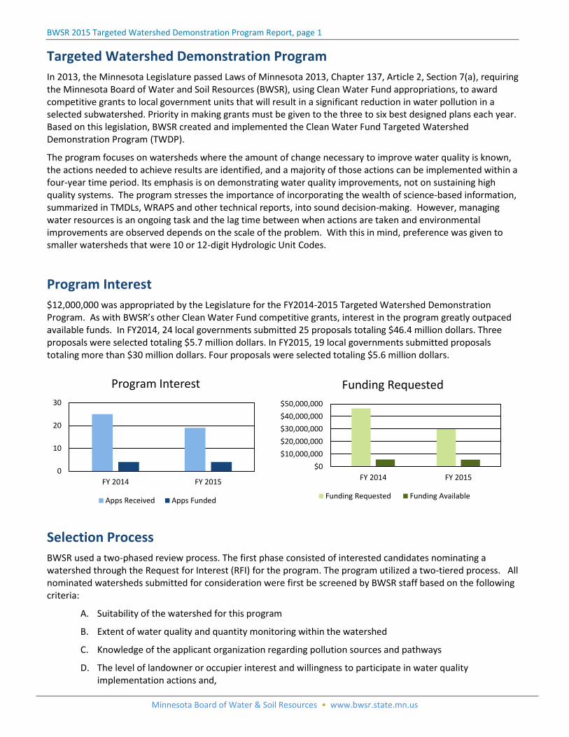
$12,000,000 was appropriated by the Legislature for the FY2014-2015 Targeted Watershed Demonstration Program. As with BWSR’s other Clean Water Fund competitive grants, interest in the program greatly outpaced available funds. In FY2014, 24 local governments submitted 25 proposals totaling $46.4 million dollars. Three proposals were selected totaling $5.7 million dollars. In FY2015, 19 local governments submitted proposals totaling more than $30 million dollars. Four proposals were selected totaling $5.6 million dollars.
Selection Process
BWSR used a two-phased review process. The first phase consisted of interested candidates nominating a watershed through the Request for Interest (RFI) for the program. The program utilized a two-tiered process. All nominated watersheds submitted for consideration were first be screened by BWSR staff based on the following criteria:
A. Suitability of the watershed for this program
B. Extent of water quality and quantity monitoring within the watershed
C. Knowledge of the applicant organization regarding pollution sources and pathways
D. The level of landowner or occupier interest and willingness to participate in water quality implementation actions and,
$0
$10,000,000
$20,000,000
$30,000,000
$40,000,000
$50,000,000
FY 2014 FY 2015
Funding Requested
Funding Requested Funding Available
0
10
20
30
FY 2014 FY 2015
Program Interest
Apps Received Apps Funded
BWSR 2015 Targeted Watershed Demonstration Program Report, page 2
Minnesota Board of Water & Soil Resources • www.bwsr.state.mn.us
E. The availability of financial and technical resources to the proposed watershed
The highest screened applicants were deemed candidates for final selection and were invited for an interview with the interagency Selection Committee, comprised of representatives of the Minnesota Pollution Control Agency, Minnesota Department of Natural Resources, Minnesota Department of Agriculture, Minnesota Department of Health and BWSR.
The criteria used during the interview process were:
A. The efforts of proposer to address the long-term sustainability of soil and water resources within their jurisdiction;
B. A systematic way to identify and track non-point water quality efforts can be demonstrated;
C. An understanding of social and cultural barriers within the watershed can be demonstrated;
D. The amount of existing local effort occurring within the watershed and the commitment of other agencies, non-profits, and private interest; and,
E. The evaluation plan for the project.
In March 2014 the board funded the first group of Targeted Watershed Demonstration Program grants. Projects receiving funds were:
Cedar River Watershed District, $1.5 million award for Dobbins Creek Watershed
Rice Creek Watershed District, $3 million award for Long Lake Watershed
Crow Wing Soil and Water Conservation District, $1.2 million award for Serpent Lake Subwatershed
In December 2014 a second round of grant announcements was made, awarding an additional $5.6 million in Targeted Watershed Demonstration Grants to four watersheds throughout the state. Those projects were:
Chisago SWCD, $887,632 award for the Chisago Chain of Lakes Watershed
Cook SWCD, $829,000 award for the Poplar River Watershed
Nicollet SWCD, $1.7 million award for the Seven Mile Creek Watershed
Scott County Water Management Organization, $2.2 million award for the Sand Creek Watershed

BWSR 2015 Targeted Watershed Demonstration Program Report, page 3
Minnesota Board of Water & Soil Resources • www.bwsr.state.mn.us
Locations of the seven projects selected in FY2014 and FY2015 for the Targeted Watershed Demonstration Program.
BWSR 2015 Targeted Watershed Demonstration Program Report, page 4
Minnesota Board of Water & Soil Resources • www.bwsr.state.mn.us
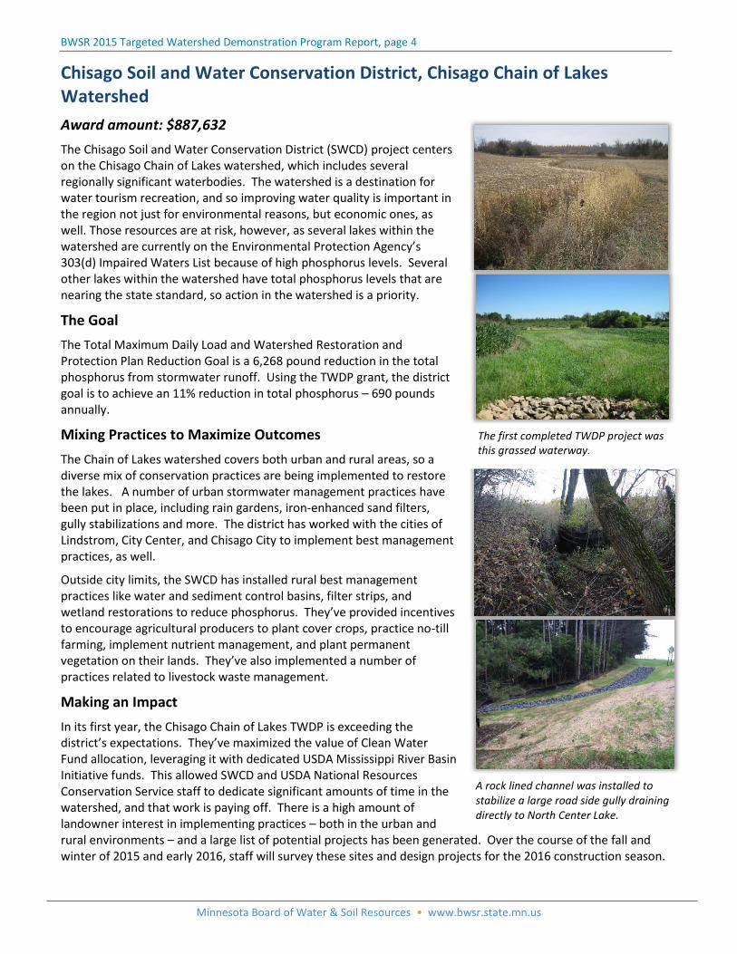
A rock lined channel was installed to stabilize a large road side gully draining directly to North Center Lake.
Chisago Soil and Water Conservation District, Chisago Chain of Lakes Watershed
Award amount: $887,632
The Chisago Soil and Water Conservation District (SWCD) project centers on the Chisago Chain of Lakes watershed, which includes several regionally significant waterbodies. The watershed is a destination for water tourism recreation, and so improving water quality is important in the region not just for environmental reasons, but economic ones, as well. Those resources are at risk, however, as several lakes within the watershed are currently on the Environmental Protection Agency’s 303(d) Impaired Waters List because of high phosphorus levels. Several other lakes within the watershed have total phosphorus levels that are nearing the state standard, so action in the watershed is a priority.
The Goal
The Total Maximum Daily Load and Watershed Restoration and Protection Plan Reduction Goal is a 6,268 pound reduction in the total phosphorus from stormwater runoff. Using the TWDP grant, the district goal is to achieve an 11% reduction in total phosphorus – 690 pounds annually.
Mixing Practices to Maximize Outcomes
The Chain of Lakes watershed covers both urban and rural areas, so a diverse mix of conservation practices are being implemented to restore the lakes. A number of urban stormwater management practices have been put in place, including rain gardens, iron-enhanced sand filters, gully stabilizations and more. The district has worked with the cities of Lindstrom, City Center, and Chisago City to implement best management practices, as well.
Outside city limits, the SWCD has installed rural best management practices like water and sediment control basins, filter strips, and wetland restorations to reduce phosphorus. They’ve provided incentives to encourage agricultural producers to plant cover crops, practice no-till farming, implement nutrient management, and plant permanent vegetation on their lands. They’ve also implemented a number of practices related to livestock waste management.
Making an Impact
In its first year, the Chisago Chain of Lakes TWDP is exceeding the district’s expectations. They’ve maximized the value of Clean Water Fund allocation, leveraging it with dedicated USDA Mississippi River Basin Initiative funds. This allowed SWCD and USDA National Resources Conservation Service staff to dedicate significant amounts of time in the watershed, and that work is paying off. There is a high amount of landowner interest in implementing practices – both in the urban and rural environments – and a large list of potential projects has been generated. Over the course of the fall and winter of 2015 and early 2016, staff will survey these sites and design projects for the 2016 construction season.
The first completed TWDP project was this grassed waterway.
BWSR 2015 Targeted Watershed Demonstration Program Report, page 5
Minnesota Board of Water & Soil Resources • www.bwsr.state.mn.us
Dobbins Creek, Cedar River Watershed District
Awarded amount: $1,500,000
Located at the headwaters of the Cedar River, the unique geography of the Dobbins Creek watershed makes for some distinct resource challenges. There is almost no natural storage in the area, and significant elevation changes, so conditions during a rain event are much like pouring water down a tilted kitchen table. The resulting runoff and stream channel erosion dramatically reduces water quality. During a five-inch rain event, the creek sends approximately 10,250 tons of sediment through the system, a problem that this project will help address.
Dobbins Creek is impaired for turbidity, which means the water is cloudy, negatively impacting aquatic life. The Cedar River Watershed District will implement an entire suite of practices that, collectively, will improve the water quality of the stream so it can support environmentally sensitive fish and macroinvertebrates.
The Goal
The work being down with these program dollars will bring the district to 15% of its sediment reduction goal for the watershed, with leveraged dollars from other funding sources accelerating their progress toward that goal.
Practices that Work
To help slow down and trap the initial flows, the district is installing water and sediment basins throughout the headwaters. They’ve also targeted key areas for large scale impoundment projects that will keep water on the land. Saturated buffers and grass waterways are among the other planned practices to help improve water quality.
The district has been at work within the Dobbins Creek Watershed for over 15 years, and have the studies and modeling completed to know where the problem areas are and what practices will deliver the most meaningful results. They knew what the problems were, but they lacked the funding to make progress. This award accelerates implementation and has been the leverage the district needs to make real progress on the watershed level.
Community Commitment
Landowner support has been very high for the project, and thanks to the community’s commitment to water quality improvement, the district secured a $3 million grant from the Hormel Foundation as well USDA Mississippi River Basin Initiative funding. These dollars will be used to match local and state grant funding, allowing the district to increase its ability to put projects on the ground and reverse the declining trend for Dobbins Creek.
Over 25 projects have been completed already in the watershed, with over 30 in progress and many more in the initial stages of development.
Water and sediment control basins have been installed in farm fields to help minimize flooding and keep sediment out of the creek.
Impoundment structures like this help slow down water, minimizing erosion and helping keep sediment out of the creek.
BWSR 2015 Targeted Watershed Demonstration Program Report, page 6
Minnesota Board of Water & Soil Resources • www.bwsr.state.mn.us
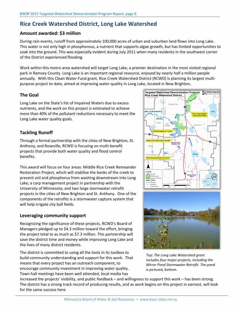
Rice Creek Watershed District, Long Lake Watershed
Amount awarded: $3 million
During rain events, runoff from approximately 100,000 acres of urban and suburban land flows into Long Lake. This water is not only high in phosphorous, a nutrient that supports algae growth, but has limited opportunities to soak into the ground. This was especially evident during July 2011 when many residents in the southwest corner of the District experienced flooding. Work within this metro-area watershed will target Long Lake, a premier destination in the most visited regional park in Ramsey County. Long Lake is an important regional resource, enjoyed by nearly half a million people annually. With this Clean Water Fund grant, Rice Creek Watershed District (RCWD) is planning its largest multi-purpose project to-date, aimed at improving water quality in Long Lake, located in New Brighton.
The Goal
Long Lake on the State’s list of Impaired Waters due to excess nutrients, and the work on this project is estimated to achieve more than 40% of the pollutant reductions necessary to meet the Long Lake water quality goals.
Tackling Runoff
Through a formal partnership with the cities of New Brighton, St. Anthony, and Roseville, RCWD is focusing on multi-benefit projects that provide both water quality and flood control benefits. This award will focus on four areas: Middle Rice Creek Remeander Restoration Project, which will stabilize the banks of the creek to prevent soil and phosphorus from washing downstream into Long Lake; a carp management project in partnership with the University of Minnesota; and two large stormwater retrofit projects in the cities of New Brighton and St. Anthony. One of the components of the retrofits is a stormwater capture system that will help irrigate city ball fields.
Leveraging community support
Recognizing the significance of these projects, RCWD’s Board of Managers pledged up to $4.3 million toward the effort, bringing the project total to as much as $7.3 million. This partnership will save the district time and money while improving Long Lake and the lives of many district residents.
The district is committed to using all the tools in its toolbox to build community understanding and support for this work. That means that every project has an outreach component, to encourage community investment in improving water quality. Town hall meetings have been well attended, local media has increased the projects’ visibility, and public feedback – and willingness to support this work – has been strong. The district has a strong track record of producing results, and as work begins on this project in earnest, will look for the same success here.
Top: The Long Lake Watershed grant includes four major projects, including the Mirror Pond Stormwater Retrofit. The pond is pictured, bottom.
BWSR 2015 Targeted Watershed Demonstration Program Report, page 7
Minnesota Board of Water & Soil Resources • www.bwsr.state.mn.us
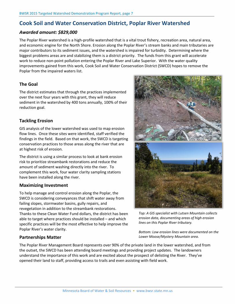
Cook Soil and Water Conservation District, Poplar River Watershed
Awarded amount: $829,000
The Poplar River watershed is a high-profile watershed that is a vital trout fishery, recreation area, natural area, and economic engine for the North Shore. Erosion along the Poplar River’s stream banks and main tributaries are major contributors to its sediment issues, and the watershed is impaired for turbidity. Determining where the biggest problems areas are and stabilizing them is a district priority. The funds from this grant will accelerate work to reduce non-point pollution entering the Poplar River and Lake Superior. With the water quality improvements gained from this work, Cook Soil and Water Conservation District (SWCD) hopes to remove the Poplar from the impaired waters list.
The Goal
The district estimates that through the practices implemented over the next four years with this grant, they will reduce sediment in the watershed by 400 tons annually, 100% of their reduction goal.
Tackling Erosion
GIS analysis of the lower watershed was used to map erosion flow lines. Once these sites were identified, staff verified the findings in the field. Based on that work, the SWCD is targeting conservation practices to those areas along the river that are at highest risk of erosion.
The district is using a similar process to look at bank erosion risk to prioritize streambank restorations and reduce the amount of sediment washing directly into the river. To complement this work, four water clarity sampling stations have been installed along the river.
Maximizing Investment
To help manage and control erosion along the Poplar, the SWCD is considering conveyances that shift water away from failing slopes, stormwater basins, gully repairs, and revegetation in addition to the streambank restorations. Thanks to these Clean Water Fund dollars, the district has been able to target where practices should be installed – and which specific practices will be the most effective to help improve the Poplar River’s water clarity.
Partnerships Matter
The Poplar River Management Board represents over 90% of the private land in the lower watershed, and from the outset, the SWCD has been attending board meetings and providing project updates. The landowners understand the importance of this work and are excited about the prospect of delisting the River. They’ve opened their land to staff, providing access to trails and even assisting with field work.
Top: A GIS specialist with Lutsen Mountain collects erosion data, documenting areas of high erosion lines on this Poplar River tributary. Bottom: Low erosion lines were documented on the Lower Moose/Mystery Mountain area.
BWSR 2015 Targeted Watershed Demonstration Program Report, page 8
Minnesota Board of Water & Soil Resources • www.bwsr.state.mn.us
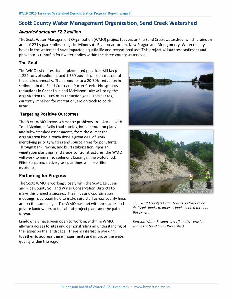
Scott County Water Management Organization, Sand Creek Watershed
Awarded amount: $2.2 million
The Scott Water Management Organization (WMO) project focuses on the Sand Creek watershed, which drains an area of 271 square miles along the Minnesota River near Jordan, New Prague and Montgomery. Water quality issues in the watershed have impacted aquatic life and recreational use. This project will address sediment and phosphorus runoff in four water bodies within the three-county watershed.
The Goal
The WMO estimates that implemented practices will keep 1,332 tons of sediment and 1,380 pounds phosphorus out of these lakes annually. That amounts to a 20-30% reduction in sediment in the Sand Creek and Porter Creek. Phosphorus reductions in Cedar Lake and McMahon Lake will bring the organization to 100% of its reduction goal. These lakes, currently impaired for recreation, are on track to be de-listed.
Targeting Positive Outcomes
The Scott WMO knows where the problems are. Armed with Total Maximum Daily Load studies, implementation plans, and subwatershed assessments, from the outset the organization had already done a great deal of work identifying priority waters and source areas for pollutants. Through bank, ravine, and bluff stabilization, riparian vegetation plantings, and grade control structures, the WMO will work to minimize sediment loading in the watershed. Filter strips and native grass plantings will help filter nutrients.
Partnering for Progress
The Scott WMO is working closely with the Scott, Le Sueur, and Rice County Soil and Water Conservation Districts to make this project a success. Trainings and coordination meetings have been held to make sure staff across county lines are on the same page. The WMO has met with producers and private landowners to talk about project plans and the path forward.
Landowners have been open to working with the WMO, allowing access to sites and demonstrating an understanding of the issues on the landscape. There is interest in working together to address these impairments and improve the water quality within the region.
Top: Scott County’s Cedar Lake is on track to be de-listed thanks to projects implemented through this program. Bottom: Water Resources staff analyze erosion within the Sand Creek Watershed.
BWSR 2015 Targeted Watershed Demonstration Program Report, page 9
Minnesota Board of Water & Soil Resources • www.bwsr.state.mn.us
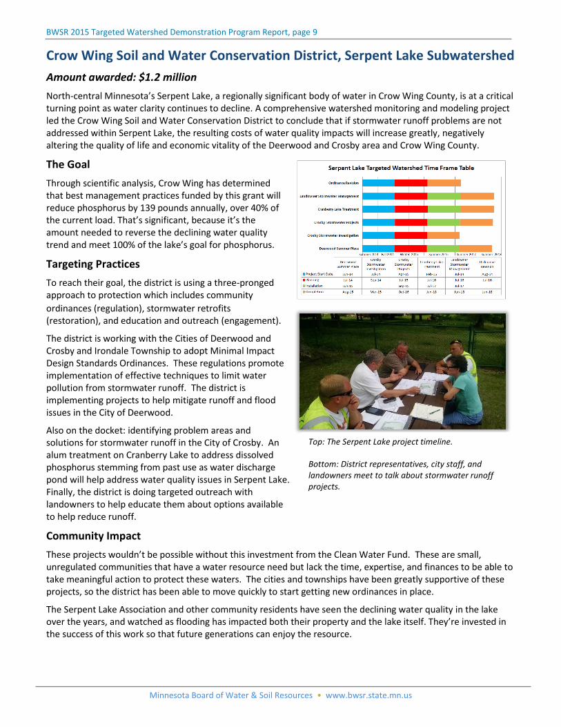
Crow Wing Soil and Water Conservation District, Serpent Lake Subwatershed
Amount awarded: $1.2 million
North-central Minnesota’s Serpent Lake, a regionally significant body of water in Crow Wing County, is at a critical turning point as water clarity continues to decline. A comprehensive watershed monitoring and modeling project led the Crow Wing Soil and Water Conservation District to conclude that if stormwater runoff problems are not addressed within Serpent Lake, the resulting costs of water quality impacts will increase greatly, negatively altering the quality of life and economic vitality of the Deerwood and Crosby area and Crow Wing County.
The Goal
Through scientific analysis, Crow Wing has determined that best management practices funded by this grant will reduce phosphorus by 139 pounds annually, over 40% of the current load. That’s significant, because it’s the amount needed to reverse the declining water quality trend and meet 100% of the lake’s goal for phosphorus.
Targeting Practices
To reach their goal, the district is using a three-pronged approach to protection which includes community
ordinances (regulation), stormwater retrofits (restoration), and education and outreach (engagement).
The district is working with the Cities of Deerwood and Crosby and Irondale Township to adopt Minimal Impact Design Standards Ordinances. These regulations promote implementation of effective techniques to limit water pollution from stormwater runoff. The district is implementing projects to help mitigate runoff and flood issues in the City of Deerwood.
Also on the docket: identifying problem areas and solutions for stormwater runoff in the City of Crosby. An alum treatment on Cranberry Lake to address dissolved phosphorus stemming from past use as water discharge pond will help address water quality issues in Serpent Lake. Finally, the district is doing targeted outreach with landowners to help educate them about options available to help reduce runoff.
Community Impact
These projects wouldn’t be possible without this investment from the Clean Water Fund. These are small, unregulated communities that have a water resource need but lack the time, expertise, and finances to be able to take meaningful action to protect these waters. The cities and townships have been greatly supportive of these projects, so the district has been able to move quickly to start getting new ordinances in place.
The Serpent Lake Association and other community residents have seen the declining water quality in the lake over the years, and watched as flooding has impacted both their property and the lake itself. They’re invested in the success of this work so that future generations can enjoy the resource.
Top: The Serpent Lake project timeline. Bottom: District representatives, city staff, and landowners meet to talk about stormwater runoff projects.
BWSR 2015 Targeted Watershed Demonstration Program Report, page 10
Minnesota Board of Water & Soil Resources • www.bwsr.state.mn.us
Nicollet Soil and Water Conservation District, Seven Mile Creek Watershed
Awarded amount: $1.7 million
The Nicollet Soil and Water Conservation District (SWCD) project centers on the Seven Mile Creek watershed, which is the priority watershed for Nicollet County. The creek, a designated trout stream, is on the state’s impaired waters list because of sediment levels, nutrients and other pollutants that affect aquatic life, recreation, and drinking water. The realities of agricultural economics can make conservation in this part of the state challenging, but thanks to the focused projects within this grant and its high visibility in the region, the district is making real progress.
The Goal
The district will achieve 40-50% of the watershed goal for sediment reduction, 15-25% of the goal for nutrient reduction, and 20-30% of the goal for E. coli reduction.
Moving the Needle
Nicollet has not historically had significant financial resources to put toward conservation best management practices, and does not work in a culture where many farmers seek out that type of assistance from their SWCD. This infusion of funding has given the district the flexibility to respond to landowners’ needs in situationally-appropriate ways both through conservation implementation dollars and increased staff outreach. The district will implement a variety of conservation practices, including drainage water management, woodchip bioreactors, drainage swales, water and sediment control basins, livestock waste management, and cover crops.
For the district, it’s not just been an opportunity to get more conservation on the ground, but to change the conversation about their work with landowners and create lasting connections that will benefit the watershed moving forward.
Community Responds
Beyond increased outreach to landowners and agricultural producers, the grant has allowed the district to expand the outreach it does to a broader group of watershed stakeholders: other residents, county park users, member of the public interested in clean water. These voices have added important, diverse perspectives to the conversation.
The community reaction has been overwhelmingly positive. There’s been a great deal of media interest in the project, and over 120 people attended three different public events in the fall of 2015 geared toward getting people involved in clean water work. Landowners have also recognized that financial support from the district for implementation of practices minimizes the risk of trying a different approach, and the successes they’ve seen have generated interest from other farmers in the community.
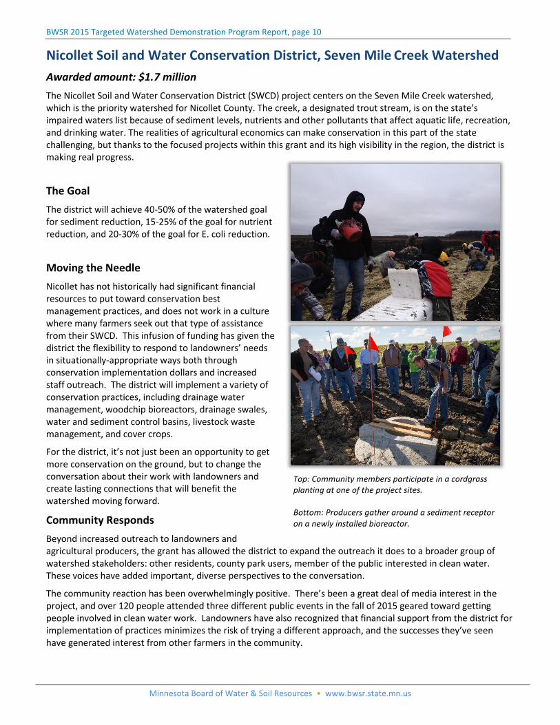
Top: Community members participate in a cordgrass planting at one of the project sites. Bottom: Producers gather around a sediment receptor on a newly installed bioreactor.
BWSR 2015 Targeted Watershed Demonstration Program Report, page 11
Minnesota Board of Water & Soil Resources • www.bwsr.state.mn.us
Summary
At the time of this report, project watersheds are one year into a four year grant period. In two of the seven watersheds (Dobbins Creek and Chisago Chain of Lakes), significant federal and private dollars were leveraged as a result of receiving this funding and will accelerate implementation efforts. To assess the progress being made in each of the selected watersheds, milestone schedules have been established along with identified goals that are specific, measurable, results-orientated and time-bound. To date, each of the seven watersheds are on track to meet their watershed reduction goals.
Specific watershed outcomes expected:
Fully restore two lakes (Cedar and McMahon Lakes) and one stream (Popular River)
Prevent one lake (Serpent Lake) from becoming impaired
Meet 10-40% of the pollution reduction goals in other targeted water bodies (Sand Creek, Dobbins Creek, Chisago Chain of Lakes, Seven Mile Creek, and Long Lake)
Factors common to all of the selected watersheds and which are deemed critical to achieving meaningful and measurable restoration and protection are:
Solid baseline of water quality data and a plan to continue monitoring into the future to track results and trends
Science-driven implementation plans
An understanding of the social and cultural barriers within the watershed and a plan to continue to build community capacity and be intentional about building relationships and trust with land owners.
Have on-going efforts to address the long-term sustainability of soil and water resources within the watershed
Building off of momentum of existing local efforts and have the commitment of other state agencies, non-profits, and private interest
Conclusion/Recommendations
The Targeted Watershed Demonstration Program was designed around meeting sub-watershed scale water quality goals aimed to restore or protect entire waterbodies. As a demonstration program, the primary goal is to show that the concentrated efforts of various targeted management actions can have a positive impact on water quality. Various management actions have not been limited to structural BMPs but include all tools in the watershed management toolbox necessary to achieve significant pollutant reductions.
Targeting watershed implementation funds to smaller watershed areas (HUC 10-12 digit watersheds) has shown to be a scale at which reductions in pollution sources are at an order of magnitude necessary to achieve significant progress toward an established water goal/objective is successful.
Quantifiable changes to physical and chemical measures of water quality from implementation of restoration and protection projects do take time to see. It’s important that agency and project partners continue to monitor and evaluate the progress each watershed is making toward water quality goals over an extended period of time.
Ensure future funding recognizes the importance of all tools in the watershed management toolbox including structural and non-structural best management practices, outreach, engagement and enforcement.
The agency recommends that the Targeted Watershed Demonstration Program become a permanent part of the agency’s non-point restoration and protection programs.
The agency supports that a portion of future Clean Water Fund appropriations be allocated to this program.
Minnesota Board of Water & Soil Resources • www.bwsr.state.mn.us