clermont flood 1916 - harden up - protecting...
TRANSCRIPT

CASE STUDY: Clermont Floods, 1916 By Mr Jeff Callaghan
The early location of Clermont was particularly prone to destructive flooding. This was due to Clermont's location on a flood plain between a lagoon and Sandy Creek, and just downstream from the junction of Sandy Creek with Wolfgang Creek. Prior to 1916 the worst flood there was in 1870 and from local legend men drank in the hotel while up to their chests in water. The 1916 flood was to far exceed the 1870 event and the final death toll was somewhere between 61 and 70. Telegraph and telephone lines were knocked down, so it was some days before news of the disaster reached the outside world and relief measures could be taken. The survivors had meanwhile started the arduous task of cleaning up the mess and burying the dead. The lower part of the town between the lagoon and Sandy Creek was never rebuilt, and settlement shifted to higher ground. For the survivors, serious lessons were learnt about developing settlements on flood plains.
At 9 a.m. on Tuesday 26th December 1916 a severe tropical cyclone was located east of the Whitsunday Group and was moving towards the coast. At 4am 27 December 1916 it passed over the Dent Island Lighthouse (Figure 1) where a central pressure of 958hPa was recorded. The centre crossed the coast just before 9am 28 December and severe wind damage was reported during the day around Finch Hatton. By 9pm Wednesday 27th December, the night of commencement of the flood, it was located approximately 90km north of Clermont and crossing the Denham Range, the Watershed between the Isaac and Burdekin Rivers. By 4am on the 28th the cyclone was just to the southeast of "Kilcummin" and northwest of Clermont.
Figure 1 Landfall of the Clermont Cyclone with the dashed white line indicating its track. Mackay and Bowen wind and pressure observations at 9am 27 December 1916 are plotted.
Clermont Floods, 1916 Data by J. Callaghan 22 September 2011
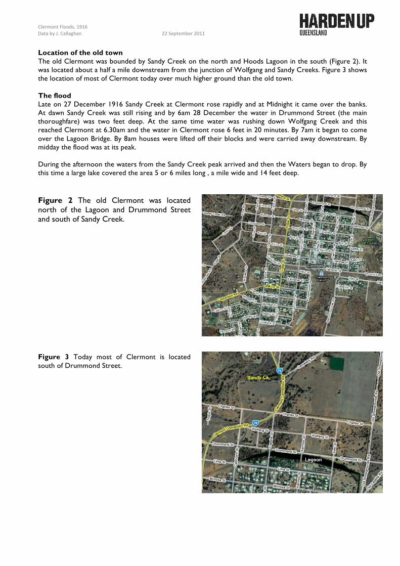
Location of the old town The old Clermont was bounded by Sandy Creek on the north and Hoods Lagoon in the south (Figure 2). It was located about a half a mile downstream from the junction of Wolfgang and Sandy Creeks. Figure 3 shows the location of most of Clermont today over much higher ground than the old town. The flood Late on 27 December 1916 Sandy Creek at Clermont rose rapidly and at Midnight it came over the banks. At dawn Sandy Creek was still rising and by 6am 28 December the water in Drummond Street (the main thoroughfare) was two feet deep. At the same time water was rushing down Wolfgang Creek and this reached Clermont at 6.30am and the water in Clermont rose 6 feet in 20 minutes. By 7am it began to come over the Lagoon Bridge. By 8am houses were lifted off their blocks and were carried away downstream. By midday the flood was at its peak. During the afternoon the waters from the Sandy Creek peak arrived and then the Waters began to drop. By this time a large lake covered the area 5 or 6 miles long , a mile wide and 14 feet deep. Figure 2 The old Clermont was located north of the Lagoon and Drummond Street and south of Sandy Creek. Figure 3 Today most of Clermont is located south of Drummond Street.

Clermont Floods, 1916 Data by J. Callaghan 22 September 2011 Rainfall In Figure 4 the track of the cyclone is shown together with the rainfall registrations over the 24 hour period up to 9am 28 December. Most of this rain fell over the 15-hour period from 6pm to 9am. The heaviest rainfall was in a zone 30 to 60km east of the track of the cyclone. From Figure 5 this heavy rainfall zone passed over the catchment of Wolfgang and Sandy Creek. However, as can be seen, Sandy Creek was mainly affected downstream of Clermont. The rainfall totals are staggering for an inland location when you consider the record daily rainfall for Tully, one of the wettest locations in Australia, is 606mm. Obviously the tropical cyclone kept its inner core structure intact as it made its way towards Clermont and is a sobering message for the potential inundation, which is possible so far from the coast.
Figure 4 24hour rainfall totals (mm) in the 24hours to 9am 28 December 1916 with the band of maximum rainfall (green dotted area) parallel to the cyclone track (black dashed line.
Figure 5 Illustrating how the area of
heaviest rain passed over the Wolfgang and Sandy Creek
Catchments. However the main portion of the Sandy Creek
catchment affected flows off to the southeast and does not affect
Clermont.

Clermont Floods, 1916 Data by J. Callaghan 22 September 2011
Damage Photographs
Figure 6 Flood damage at Clermont 1916 (state Library)
Figure 7 Hotel Leo being moved after 1916 Clermont flood (state Library)
Figure 8 Flood damage to bridge at Clermont 1916 (state Library)

Clermont Floods, 1916 Data by J. Callaghan 22 September 2011
Figure 9 Flood damage at Clermont 1916 (state Library)
Figure 10 Flood Memorial in Clermont. References Harman, B. and Whitingham, H. E.. 1970. A Documentary and Investigation of the Clermont Storm, December 1916. Irrigation and Water Supply Commission Queensland, 50 pages.