climate and global change notes 24-1 oceanic motions & climate climate and ocean currents ocean...
TRANSCRIPT

Climate and Global Change Notes
24-1
Oceanic Motions & Climate
Climate and Ocean Currents
Ocean CurrentsGulf StreamCalifornia CurrentThermohaline Circulation
El Niño - La Niña Patterns
Science Concepts
Newton’s Laws of MotionHorizontal Forces
Wind DragCoriolis Force
The Earth System (Kump, Kastin & Crane)
• Chap. 5 (Fig. 5-2, pp. 86-87, Fig. 5-12)

Climate and Global Change Notes
24-2
Ocean Currents
Sea Surface Temperature - 29 October 1995

Climate and Global Change Notes
24-3
Currents
Ocean Currents

Climate and Global Change Notes
24-4
Ocean Currents
Gulf Stream

Climate and Global Change Notes
24-5
Ocean Currents
Gulf Stream

Climate and Global Change Notes
24-6
Ocean Currents
California Current

Climate and Global Change Notes
24-7
QuickTime™ and aTIFF (Uncompressed) decompressor
are needed to see this picture.
Ocean Currents
Upwelling
• Strong northerly winds (red arrow) prevail along the coast of southern California. These winds provide a drag force toward the south on the surface water. Once the water begins to move, the coriolis force, acting to the right of the motion, causes the water to actually flow away from the coast, i.e., to the west. This causes cold deeper water (darker blue) to upwell alongthe shore of the eastern Pacific.
http://oceanexplorer.noaa.gov/explorations/02quest/background/upwelling/media/fig1_cartoon.html

Climate and Global Change Notes
24-8
QuickTime™ and aTIFF (Uncompressed) decompressor
are needed to see this picture.
California Stratus Clouds
• Cold water induced clouds along the coast of southern California - different days
Ocean Currents
http://oceanexplorer.noaa.gov/explorations/02quest/background/upwelling/upwelling.html
QuickTime™ and aTIFF (Uncompressed) decompressor
are needed to see this picture.
http://earthobservatory.nasa.gov/Newsroom/NewImages/images.php3?img_id=17421

Climate and Global Change Notes
24-9
Upwelling
• Strong southeasterly winds (red arrow) prevail along the coast of southern Ecuador and Peru. These winds provide a drag force to the north on the surface water.Once the water begins tomove, the coriolis force
causes the water to actually move away from the coast. This causes cold, nutrient-rich water (dark blue) to upwell along the shore of the eastern Pacific.
• Waters off Peru show increasedphytoplankton biomass resulting from ocean upwelling in this area. This enriched region extends 500 to 1,000 km off shore.
Ocean Currents
QuickTime™ and aTIFF (Uncompressed) decompressor
are needed to see this picture.
http://ww2010.atmos.uiuc.edu/(Gl)/guides/mtr/eln/upw.rxml
Climate and Global Change Notes
24-10
QuickTime™ and aTIFF (Uncompressed) decompressor
are needed to see this picture.
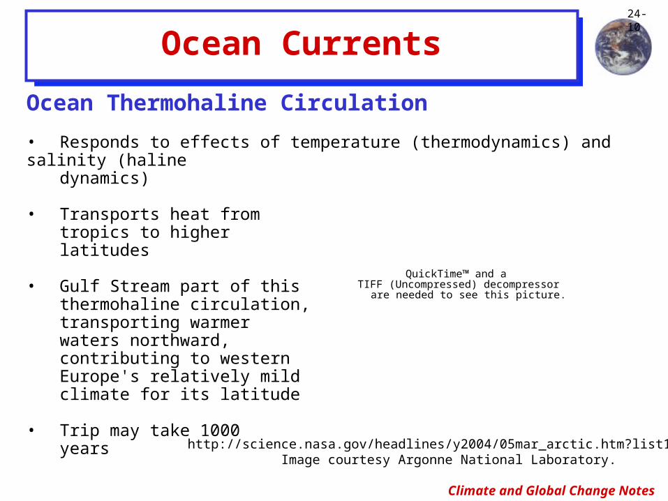
Ocean Currents
Ocean Thermohaline Circulation
• Responds to effects of temperature (thermodynamics) and salinity (haline dynamics)
• Transports heat from tropics to higher latitudes
• Gulf Stream part of this thermohaline circulation, transporting warmer waters northward, contributing to western Europe's relatively mild climate for its latitude
• Trip may take 1000 years
http://science.nasa.gov/headlines/y2004/05mar_arctic.htm?list104690Image courtesy Argonne National Laboratory.

Climate and Global Change Notes
24-11
QuickTime™ and aTIFF (Uncompressed) decompressor
are needed to see this picture.
Ocean Currents
Ocean Thermohaline Circulation (Con’t)
• Arctic perennial sea ice has been decreasing at a rate of 9% per decade
• Image show the minimum sea ice concentration for the year 1979 and 2003
• Data were collected by the Defense Meteorological Satellite Program (DMSP) Special Sensor Microwave Imager (SSMI)
http://www.gsfc.nasa.gov/topstory/2003/1023esuice.html
QuickTime™ and aTIFF (Uncompressed) decompressor
are needed to see this picture.
1979
2003
Climate and Global Change Notes
24-12
Ocean Thermohaline Circulation (Con’t)
• Possible feedback mechanism
- Melting Arctic sea ice could dump enough freshwater into the North Atlantic to effect thermohaline circulation
> Freshwater would result from the ice-melt
> Main contributor would be increased rain and snow in the region
‡ Retreating ice exposes more oceansurface, allowing more moisture to evaporate, leading to more precipitation
Ocean Currents

Climate and Global Change Notes
24-13
- Gulf Stream, etc. (red) carry heat northward near the ocean's surface, with some of that warm surface water returning in a subtropical loop
- Water reaching high latitudes is cold, salty and dense (yellow) and sinks 1-6 km, primarily near blue stars
- Colder, deep water (blue) flows southward
- White bands indicate sections along which researchers have monitored current flows
- Observations over 47 y period by H Brydon and H. Longworth suggests that the circulation is slowing
Levi, B.G., 2006: “Is There a Slowing in the Atlantic Ocean's Overturning Circulation?”, Physics Today, April, 26-28.
Ocean Thermohaline Circulation (Con’t)
• Possible feedback mechanism (Con’t)
- Because saltwater is denser and heavier than freshwater, more freshwater could disrupt thermohaline circulation which would reduce the flow of warm surface water northward
- Result in colder Europe
Ocean Currents

Climate and Global Change Notes
24-14
El Niño - La Niña & Climate
Climate and Ocean Currents (Con’t)
El Niño - La NiñaCausesEffects
Science Concepts
DefinitionDensity
TemperatureSalinity
The Earth System (Kump, Kastin & Crane)
• Chap. 7 (pp. 117-118, 126-131)

Climate and Global Change Notes
24-15
El Niño - La Niña
http://www.pmel.noaa.gov/tao/elnino/gif/reynolds/nancy4.gif
30
26
22
18
La Niña - December 1998
Normal - December 1993
El Niño - December 1997
°C

Climate and Global Change Notes
24-16
El Niño - La Niña

Climate and Global Change Notes
24-17
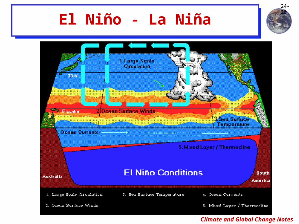
Effects of El Niño
• Changes in sea-surface temperature during El Niño directly affect the atmospheric circulation in the tropical Pacific.
• Changes in the tropical Pacific atmospheric circulation can in turn dramatically alter climate patterns in other regions of the tropics, as well as regions far removed from the tropics. The linkages of weather conditions over great distances are called teleconnections.
- El Nino minus La Ninaprecipitation difference (mm/day)
El Niño - La Niña
QuickTime™ and aTIFF (LZW) decompressor
are needed to see this picture.
http://www.gewex.org/GPCP_data_products_9-2006.pdf

Climate and Global Change Notes
24-18
El Niño - La Niña

Climate and Global Change Notes
24-19
Effects of El Niño (Con’t)
• Changes in the tropical Pacific atmospheric circulation (Con’t)
- During normal, or non-El Niño years, the ITCZ shifts southward during the later months of the calendar year, achieving maximum southward displacement during January.
- During El Niño, this normal pattern is altered. The usually warm waters of the equatorial Pacific can cause the ITCZ to travel further south than normal and can inhibit the northward travel of the ITCZ. The disruption of the ITCZ can have important implications for “normal” rainfall patterns.
El Niño - La Niña
Climate and Global Change Notes
24-20
El Niño - La Niña

Climate and Global Change Notes
24-21
El Niño - La Niña
http://www.cpc.ncep.noaa.gov/products/analysis_monitoring/impacts/warm.gif
http://www.cpc.ncep.noaa.gov/products/analysis_monitoring/impacts/cold.gif
La Niña / El Niño Differences

Climate and Global Change Notes
24-22
El Niño - La Niña
http://earthobservatory.nasa.gov/Newsroom/NewImages/images.php3?img_id=16829
La Niña / El Niño Differences (Con’t)• Changes in precipitation patterns
• Note U.S. Gulf Coast is blue, i.e., wetter than usual in El Niño years and drier than usual in La Niña years

Climate and Global Change Notes
24-23
Ocean Productivity
• During an El Niño, decreased primary productivity occurs in the waters along the western coast of South America and along the equatorial upwelling zone. Primary production is the conversion of nutrients in the water to plant matter, mainly by phytoplankton, and is the base of the oceans food chain. The higher the phytoplankton concentration, the more productive the water.
• The color of the ocean is an indication of the amount of chlorophyll present in the upper part of the ocean. The amount of chlorophyll in the ocean provides information concerning the phytoplankton concentration in the ocean.
- Biologically productive surface waters appear green because of the high chlorophyll content of the phytoplankton found in the water.
- Biologically unproductive waters appear deep blue due to the lack of phytoplankton and chlorophyll.
• Satellite images have been used to trace the decrease in primary productivity as far north as the waters off the western coast of the United States and as far south as the central Chile coast.
El Niño - La Niña

Climate and Global Change Notes
24-24
Ocean Productivity (Con’t)
• The Coastal Zone Color Scanner (CZCS) carried on Nimbus 7 is the instrument used to determine ocean productivity. The CZCS operated in six narrow bands in the visible region of the electromagnetic spectrum and has been used to estimate ocean productivity worldwide. The method employs ratios of blue, green and yellow images to calculate the chlorophyll content of the water, and hence the primary productivity.
A new ocean color scanner, the Sea-viewing Wide-Field Sensor (SeaWifs) has been launched to continue making ocean color measurements. While SeaWifs operates under the same principals as CZCS, SeaWifs is being designed to provide measurements which surpass the resolution and detail of CZCS.
El Niño - La Niña

Climate and Global Change Notes
24-25
El Niño - La Niña

Climate and Global Change Notes
24-26
Effects on Fertile Upwelling Zones (Con’t)
• Further up the food chain, sea mammals are also affected by the lack of fish. Sea lions and fur seals have been noted to have markedly reduced birth rates in the years following an El Niño event. Albatross, boobies, penguins, cormorants and marine iguanas are other species that are adversely affected by the lack of food. A compounding problem with El Niño is the timing of the events. The warmest sea surface temperatures and its impacts occur when many mammals are breeding. At a time when food supplies should be highest, El Niño diminishes food supplies by reducing upwelling and dampening primary food production. Loss of food has particularly detrimental effects on nursing females and their young or unborn. Territorial male mammals suffer due to their inability to move with the migrating food sources.
El Niño - La Niña

Climate and Global Change Notes
24-27
‘82-’83 El Niño Event

Climate and Global Change Notes
24-28
1982-83 El-Niño Chronologically
• May 1982:
- Slight rise in sea surface temperature off coast of Peru (less than 1/2°C) detected by drifting buoys and satellites.
• June 1982:
- Sudden atmospheric pressure increase at Darwin, Australia
- Dramatic atmospheric pressure decrease in Tahiti
- Westward tradewinds reverse direction along equatorial Pacific Ocean
- Sea-level rises over the central Pacific as the warm water pool starts moving eastward along the equator
- Deep fog blankets the central Pacific
- Dry spell begins in Australia, Indonesia and New Guinea
‘82-’83 El Niño Event
Climate and Global Change Notes
24-29
1982-83 El-Niño Chronologically (Con’t)
• July 1982:
- Sea level at Fanning and Christmas Islands are up almost 25 cm
- Precipitation amounts at Tarawa is 4 times the normal for July
• August 1982:
- Atmospheric pressure recorded at Darwin is highest in 100 years
- Atmospheric pressure recorded at Tahiti is lowest in 50 years
- Normally westward flowing ocean current reverses
- Five hurricanes form in the eastern Pacific
- Rain begins at Christmas Island during the traditional dry season
- Extremely heavy rains are reported from Kiribati to the Line Islands
‘82-’83 El Niño Event
Climate and Global Change Notes
24-30
1982-83 El-Niño Chronologically (Con’t)
• September 1982:
- In the eastern Pacific a research ship observes:
- Sea-surface temperatures 5°C higher than normal
- Upper ocean warm water layer 4 times thicker than normal
- The normal easterly cold under current flows cease
- The usual abundance of marine wildlife disappear
• October 1982:
- Kelvin wave reaches the South American coast, sea-surface temperature rises
- Record rain and flooding strike Ecuador and northern Peru
- Drought continues in Australia, Indonesia and New Guinea
‘82-’83 El Niño Event

Climate and Global Change Notes
24-31
1982-83 El-Niño Chronologically (Con’t)• November 1982:
- Over 13 times the normal rainfall is recorded in Guayaquil, Ecuador
- Fanning and Washington Islands suffer extensive erosion due to rough seas
- A rare hurricane causes damage in Hawaii, USA
- French Polynesia is devastated by the first of six major tropical cyclones
- 17 millions birds populating Christmas Islands disappear leaving their nestlings for lack of food
• December 1982:
- Remarkably deep warm water found near Panama--down to 3,300 feet
- Drought conditions spread from the Philippines all the way to Hawaii
- The tropical jet stream shifts north to California and the Northern Pacific
‘82-’83 El Niño Event

Climate and Global Change Notes
24-32
1982-83 El-Niño Chronologically (Con’t)
• January-February 1983:
- Indicators start to show a decline in the magnitude of the event, water temperature drops 5°C
- Drifting buoys shift direction and start moving west - back to normal
- Atmospheric pressure readings returns to its normal level at Darwin, Australia
- El Niño appears to be waning
• March 1983:
- Sea temperature surged upward again--inexplicably
- Along the Peru and Ecuador coasts, water suddenly warms by 7°C
- Buoys that started moving westward changed direction again
‘82-’83 El Niño Event
Climate and Global Change Notes
24-33
1982-83 El-Niño Chronologically (Con’t)• April-May 1983:
- All readings of temperature and pressure surpass the previous December peaks
• June 1983:
- Deserts of Peru, Ecuador and Bolivia receive 3.7 m of rain, instead of 12.7 cm
- Agricultural lands of northern Bolivia have received no rain for eight months
- 90% of the potato crops in northern Bolivia perishes from drought
- 40,000 adobe homes melt down and urban sewer systems burst in Bolivia
- The Galapagos Islands receive more rain in 6 weeks than in 6 normal years
- The Pacific part of Australia endures the driest summer in two centuries resulting in huge brush fires, crop and livestock losses
‘82-’83 El Niño Event

Climate and Global Change Notes
24-34
1982-83 El-Niño Chronologically (Con’t)• June 1983 (Con’t):
- 19 African countries endure severe droughts
- California and the Rockies suffer $1.1 billion damage from rains and floods
• November 1983:
- Sea-surface temperatures off the coast of Peru return to normal
• July 1984:
- Water temperatures in the Gulf of Alaska return to normal
‘82-’83 El Niño Event

Climate and Global Change Notes
24-35
History
• 1800s Spanish sailors off Peru noted
- Waters they fished were normally cold and flowed from south to north.
- Some years the waters reverse their flow and become very warm. Change usually occurred around Christmas. Sailors named the odd occurrence “El Niño” meaning “the Christ Child”.
El Niño - La Niña