climate - broads authority · 6 the changing broads... broads climate adaptation plan 2016 2 the...
TRANSCRIPT
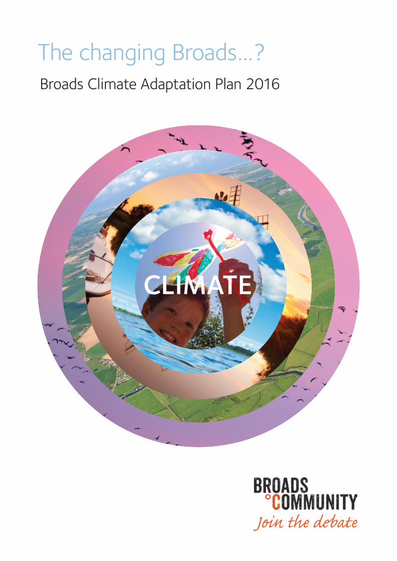
The changing Broads…? Broads Climate Adaptation Plan 2016
Join the debate
CLIMATE
Broads Climate Partnershipc/o Broads Authority62-64 Thorpe RoadNorwich NR1 1RY
Published January 2016
Broads Climate Partnership Coordinating the adaption response in the Broads
Broads Authority (lead), Environment Agency, Natural England, National Farmers Union, Norfolk County Council, local authorities, University of East Anglia
Contents
1 The changing Broads page 4
2 The changing climate page 6
3 A climate-smart response page 8
4 Being climate-smart in the Broads page 10
5 Managing flood risk page 16
6 Consultation process page 20 7 Next steps page 21
Appendices page 23
The changing Broads... ? Broads Climate Adaptation Plan 2016 3
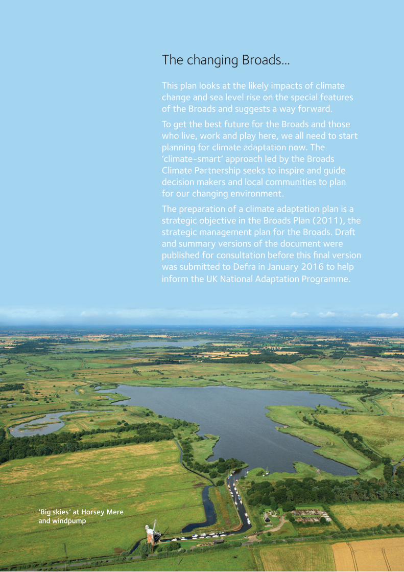
The changing Broads...
This plan looks at the likely impacts of climate change and sea level rise on the special features of the Broads and suggests a way forward.
To get the best future for the Broads and those who live, work and play here, we all need to start planning for climate adaptation now. The ‘climate-smart’ approach led by the Broads Climate Partnership seeks to inspire and guide decision makers and local communities to plan for our changing environment.
The preparation of a climate adaptation plan is a strategic objective in the Broads Plan (2011), the strategic management plan for the Broads. Draft and summary versions of the document were published for consultation before this final version was submitted to Defra in January 2016 to help inform the UK National Adaptation Programme.
‘Big skies’ at Horsey Mere and windpump
4 The changing Broads... ? Broads Climate Adaptation Plan 2016
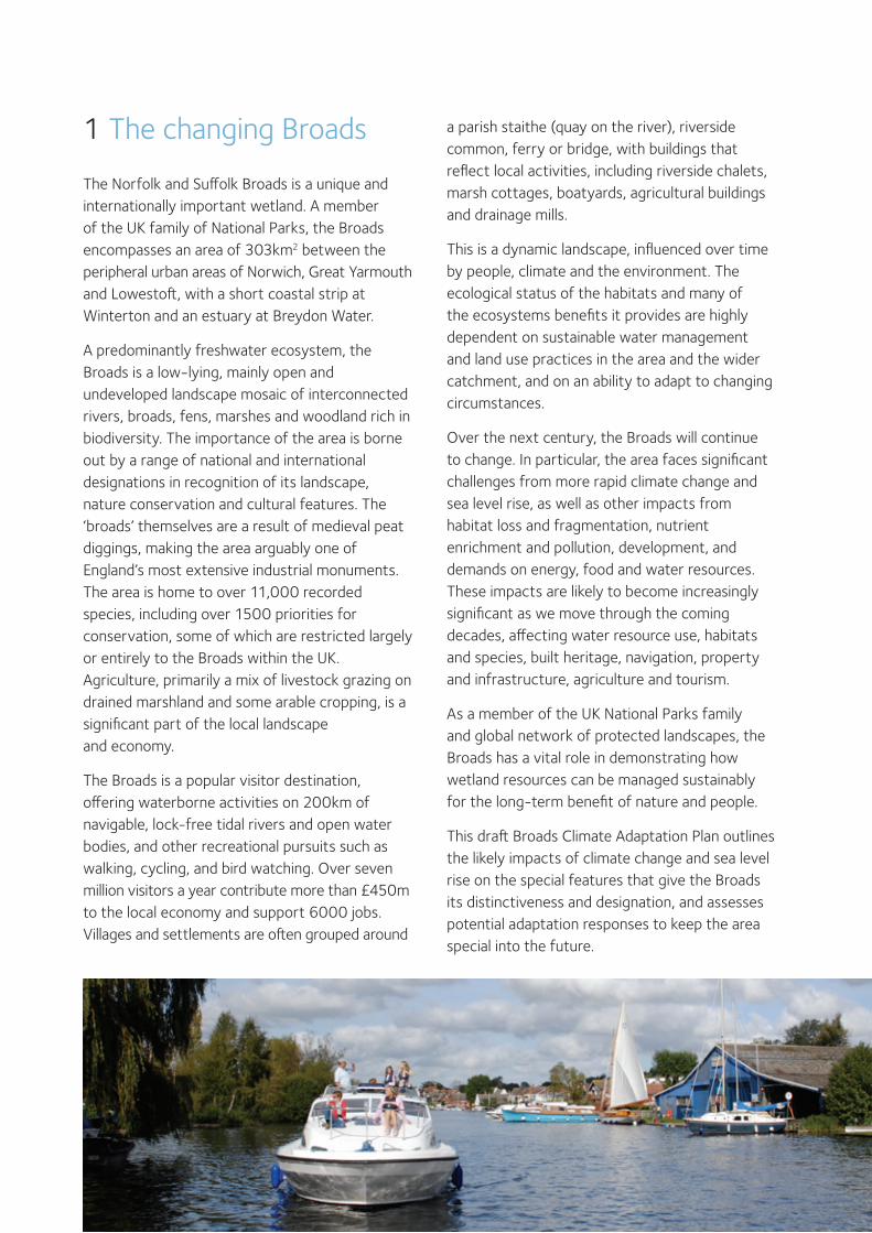
The Norfolk and Suffolk Broads is a unique and internationally important wetland. A member of the UK family of National Parks, the Broads encompasses an area of 303km2 between the peripheral urban areas of Norwich, Great Yarmouth and Lowestoft, with a short coastal strip at Winterton and an estuary at Breydon Water.
A predominantly freshwater ecosystem, the Broads is a low-lying, mainly open and undeveloped landscape mosaic of interconnected rivers, broads, fens, marshes and woodland rich in biodiversity. The importance of the area is borne out by a range of national and international designations in recognition of its landscape, nature conservation and cultural features. The ‘broads’ themselves are a result of medieval peat diggings, making the area arguably one of England’s most extensive industrial monuments. The area is home to over 11,000 recorded species, including over 1500 priorities for conservation, some of which are restricted largely or entirely to the Broads within the UK. Agriculture, primarily a mix of livestock grazing on drained marshland and some arable cropping, is a significant part of the local landscape and economy.
The Broads is a popular visitor destination, offering waterborne activities on 200km of navigable, lock-free tidal rivers and open water bodies, and other recreational pursuits such as walking, cycling, and bird watching. Over seven million visitors a year contribute more than £450m to the local economy and support 6000 jobs. Villages and settlements are often grouped around
1 The changing Broads a parish staithe (quay on the river), riverside common, ferry or bridge, with buildings that reflect local activities, including riverside chalets, marsh cottages, boatyards, agricultural buildings and drainage mills.
This is a dynamic landscape, influenced over time by people, climate and the environment. The ecological status of the habitats and many of the ecosystems benefits it provides are highly dependent on sustainable water management and land use practices in the area and the wider catchment, and on an ability to adapt to changing circumstances.
Over the next century, the Broads will continue to change. In particular, the area faces significant challenges from more rapid climate change and sea level rise, as well as other impacts from habitat loss and fragmentation, nutrient enrichment and pollution, development, and demands on energy, food and water resources. These impacts are likely to become increasingly significant as we move through the coming decades, affecting water resource use, habitats and species, built heritage, navigation, property and infrastructure, agriculture and tourism.
As a member of the UK National Parks family and global network of protected landscapes, the Broads has a vital role in demonstrating how wetland resources can be managed sustainably for the long-term benefit of nature and people.
This draft Broads Climate Adaptation Plan outlines the likely impacts of climate change and sea level rise on the special features that give the Broads its distinctiveness and designation, and assesses potential adaptation responses to keep the area special into the future.
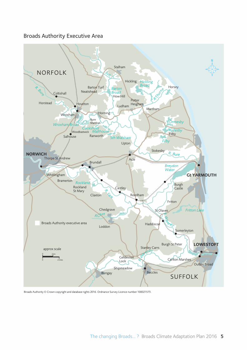
The changing Broads... ? Broads Climate Adaptation Plan 2016 5
Broads Authority © Crown copyright and database rights 2016. Ordnance Survey Licence number 100021573.
R. Bure
Ant
Rockland
Malthouse
R. Yare
SUFFOLK
Cockshoot
NORFOLK
AcleBrundall
Ludham
Reedham
Wroxham
R.Chet Fritton LakeR.W
aveney
R.W
aveney LOWESTOFT
Potter Heigham
BecclesBungay
Breydon Water
Horning
Hoveton
Coltishall
Rockland St Mary
Filby
Stalham
RanworthSalhouse
How Hill
R. Bure
Loddon
Chedgrave
Haddiscoe
Thorpe St Andrew
Hickling
St Olaves
Sth Walsham
Hickling Broad
R.Thu
rn
e Barton BroadNeatishead
Horstead
Woodbastwick
Cantley
Somerleyton
Stokesby
Burgh St Peter
Fritton
Whitlingham
Upton
Barton Turf
Geldeston Lock
Claxton
NORWICH
Bramerton
Martham
Shipmeadow
Ormesby
Filby
Rollesby
Carlton Marshes
Stanley Carrs
Burgh Castle
Bure Marshes
Horsey
Wroxham Broad
Gt YARMOUTH
Oulton Broad
approx scale2 km
2 miles
0
0
Broads Authority executive area
Broads Authority Executive Area
6 The changing Broads... ? Broads Climate Adaptation Plan 2016
2 The changing climate
Climate science We all notice changes in day-to-day weather and short-term variations in our climate such as winter storm events or flooding. Climate change science, on the other hand, analyses the average weather trends or cycles at a particular place over much longer periods of time – generally around 30-50 years, related to past centuries or millennia and looking forward to 2100 and beyond.
Climate science has been evolving for decades, using evidence from the past and computer modelling to project what is likely to happen in the future. A number of complex factors are taken into account by scientists in trying to predict how future global warming will contribute to climate change. This includes variables in future greenhouse gas emissions and changes in energy generation, land use, technology, economies and population growth. So that research between different groups is complementary and comparable, a standard set of ‘scenarios’ is used to ensure that starting conditions, historical data and projections are used consistently across the various branches of climate science1. New findings are incorporated in the scenarios, and computer modelling is gaining progressively quicker and better results.
Once greenhouse gases are in the atmosphere, they will remain there for periods of time. For example, CO2 is likely to remain for at least 30
years and perhaps for over a century. This means that, even with a rapid decline of greenhouse gas emissions in the near future, climate impacts will occur. The rate of decline of emissions is very difficult to predict, hence the range of emission scenarios being used for projections, bringing uncertainty and complexity to timings.
Climate impacts on the BroadsA report was published in 2003 that provided an overview of the potential impacts of climate change on 23 living lakes, including the Broads2. The report contained a preliminary analysis on the potential impacts on the Broads river catchment, looking at a number of state-of-the-art models, some key annual variables, and a single ‘medium-high’ emission scenario.
In 2013, the Broads Authority commissioned a more in-depth analysis of the potential climate changes projected to occur in the region containing the Broads3. This analysis used 17 climate model patterns, three time periods up to the end of the century, and a range of weather data for the four grid cells covering the Broads4. To simplify the picture, the data used for the published report concentrated on a single emission scenario and on the cell that coincides with most of the northern Broads. The projected changes were compared to an average observed climate 1961-1990.
1 The Intergovernmental Panel on Climate Change Fifth Assessment Report AR5 establishes new scenarios called Representative Concentration Pathways (RCPs). The report uses the RCP8.5 scenario.
2 Climate Change: An Overview and its Impact on the Living Lakes, a report prepared for the 8th Living Lakes Conference (Hulme, M., D. Conway and X. Lu. 2003).
3 The Potential Impacts of Climate Change on the Norfolk Broads (Price J, Tyndall Centre, UEA, 2013)
4 Grid cells determined as part of UKCIP 2009 projections, dividing UK into smaller units
The changing Broads... ? Broads Climate Adaptation Plan 2016 7
The scenario used in the report was based on high future emissions typically used in this type of study. It was chosen for several reasons: (1) It is the scenario that current emissions are most closely tracking; (2) In the 2050s, the average global climate change is predicted to be approximately 2°C warmer, thus providing guidance for adaptation planning for 2°C regardless of the timing of when it may occur; and (3) It provides information on the greatest changes that those that manage the Broads may need to prepare for in the 21st century.
Based on probable climate projections, over the coming 50 years the Broads is likely to see:
• Hotter, drier summers with more cloud-free days and future average temperatures closer to current maximum temperatures, and possibly extreme rainfall events.
•Slightlywetter,warmerwinterswithrainfallinmore intense bursts.
•Streamsandtheseagettingwarmer,with associated changes in wildlife and water patterns.
•Moreextremesintheintensityandfrequency of rainfall and storms, and possibly heatwaves and drought.
•Risingsealevelsatratesmuchfasterthanjustthrough isostatic recovery
Using this small set of climate variables also allows for consideration of other direct or indirect effects. Sea level is already rising due to land settlement. In addition, the expansion of water as it warms up suggests that sea level will be at least 30-40cm higher, possibly over a metre higher by the end of the century. If climate ‘tipping points’ are reached, perhaps enabling critical amounts of polar ice to melt, sea levels could be much higher.
Higher sea levels can hold back water trying to drain from the rivers, which can directly cause flooding. If a combination of weather and high tides causes a surge in the North Sea additional, saline water can be pushed up the rivers, putting flood defences under threat. Higher sea levels along the north-east Norfolk and north Suffolk coast also bring an increased risk of sea defences being overtopped or breached, with possible inundation and increasing incursion of saline water into a predominantly freshwater ecosystem.
Moredetailsfromthe2013climatereportareinAppendix 1.
8 The changing Broads... ? Broads Climate Adaptation Plan 2016
3 A climate-smart response
While there may be uncertainty about the rate and magnitude of climate change over the coming decades, ‘uncertainty paralysis’ needs to be avoided. Changes are already occurring and will continue to occur. The decision should not be whether to begin preparing for change, but how much change to prepare for.… it is often cheaper to design for a change than to retrofit for the change later.
Dr Jeff Price, Tyndall Centre, University of East Anglia
The process of preparing this climate adaptation plan has reinforced the difficulty of creating prescriptive adaptation options while there is still much uncertainty about when climate impacts may become significant and what the ideal solutions could be. The uncertainty about climate change should not be a reason to avoid preparing for it, but we need a robust, informed and flexible adaptation response.
Climate-smart thinking
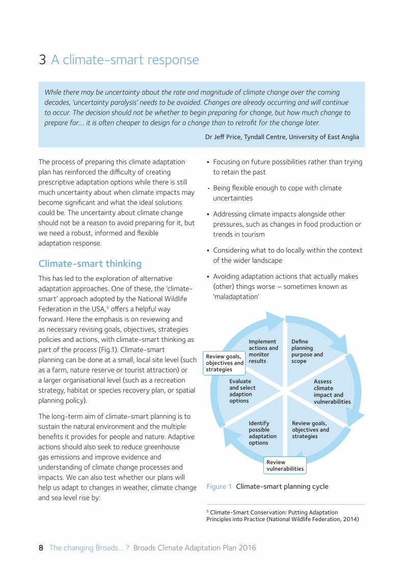
This has led to the exploration of alternative adaptation approaches. One of these, the ‘climate-smart’ approach adopted by the National Wildlife Federation in the USA,5 offers a helpful way forward. Here the emphasis is on reviewing and as necessary revising goals, objectives, strategies policies and actions, with climate-smart thinking as part of the process (Fig.1). Climate-smart planning can be done at a small, local site level (such as a farm, nature reserve or tourist attraction) or a larger organisational level (such as a recreation strategy, habitat or species recovery plan, or spatial planning policy).
The long-term aim of climate-smart planning is to sustain the natural environment and the multiple benefits it provides for people and nature. Adaptive actions should also seek to reduce greenhouse gas emissions and improve evidence and understanding of climate change processes and impacts. We can also test whether our plans will help us adapt to changes in weather, climate change and sea level rise by:
• Focusing on future possibilities rather than trying to retain the past
•Beingflexibleenoughtocopewithclimate uncertainties
• Addressing climate impacts alongside other pressures, such as changes in food production or trends in tourism
• Considering what to do locally within the context of the wider landscape
• Avoiding adaptation actions that actually makes (other) things worse – sometimes known as ‘maladaptation’
Figure 1 Climate-smart planning cycle
Implement actions and monitor results
Define planning purpose and scope
Evaluate and select adaption options
Identify possible adaptation options
Review goals, objectives and strategies
5 Climate-Smart Conservation: Putting Adaptation Principles into Practice (National Wildlife Federation, 2014)
Review vulnerabilities
Review goals, objectives and strategies
Assess climate impact and vulnerabilities
The changing Broads... ? Broads Climate Adaptation Plan 2016 9
The UK National Adaptation Programme (NAP) has developed objectives to address the greatest climate related risks and opportunities. These objectives cover four main areas across the programme:
• Increasing awareness
• Increasing resilience to current extremes
• Taking timely action for long-lead time measures
• Addressing major evidence gaps
The NAP states that:
Through good risk management, organisations can become more resilient and potentially gain economic benefit. It has been estimated that, in the wider European context, every £1 spent on adaptation represents 4 times its value in potential damages avoided.
Some measures, called low-regret actions, make economic sense because they deliver benefits now and are feasible under virtually any future climate scenario. Examples include having in place better water efficiency measures, a business continuity plan, checking insurance policies and gaining a better understanding of supply-chain risks.Manyothermeasuresaresimilarlylowcostand therefore benefits over time need only be modest to ensure they are cost-effective.
Managing change
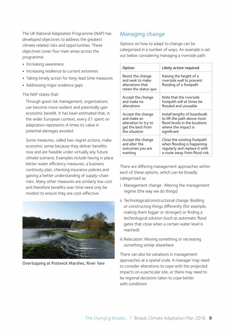
Options on how to adapt to change can be categorised in a number of ways. An example is set out below considering managing a riverside path.
There are differing management approaches within each of these options, which can be broadly categorised as:
i. Managementchange:Alteringthemanagementregime (the way we do things)
ii. Technological/constructional change: Building or constructing things differently (for example, making them bigger or stronger) or finding a technological solution (such as automatic flood gates that close when a certain water level is reached)
iii.Relocation:Movingsomethingorrecreatingsomething similar elsewhere
There can also be variations in management approaches at a spatial scale. A manager may need to consider alterations to cope with the projected impacts on a particular site, or there may need to be regional decisions taken to cope better with conditions
Option Likely action required
Resist the change and seek to make alterations that retain the status quo
Raising the height of a riverside wall to prevent flooding of a footpath
Accept the change and make no alterations
Note that the riverside footpath will at times be flooded and unusable
Accept the change and make an alteration to try to get the best from the situation
Install lengths of boardwalk to lift the path above most flood levels in the locations where the impact is significant
Accept the change and alter the outcomes you are wanting
Close the existing footpath when flooding is happening regularly and replace it with a route away from flood risk.
Overtopping at Postwick Marshes, River Yare
10 The changing Broads... ? Broads Climate Adaptation Plan 2016
4 Being climate-smart in the Broads
Special qualities
When asked what makes the Broads a special place, the qualities or feature most commonly identified include: The rivers and open water bodies (‘broads’); fens, reed beds and wet woodlands; grazing marshes and ditches; estuary and coast; navigable, lock-free waterways; farmland; abundant wildlife; historic structures, especially mills; countryside access on land and water; and tranquillity, wildness and ‘big skies’.6 Although this plan dwells on these special qualities, the wider needs of people, especially our local communities, also needs to be at the forefront of thinking.
To develop our climate-smart planning approach for the Broads, we have looked at the likely climate impacts primarily on these special qualities and identified vulnerabilities and opportunities (Table 2). For the most significant impacts, we consider what could be done to get the best for the Broads in adapting to the likely changes. We also propose
some ‘low regret’ adaptation actions that could help now while not restricting future choices that might be available as climate understanding continues to improve.
These and other options would obviously need to be considered in detail, and there are likely to be somedifficultandcomplexdecisionsahead.Manyadaptation choices will require long-term planning to gain necessary agreements, change practice or policy, or gather more evidence of what may be possible or acceptable, and reaching a consensus will sometimes be challenging. We can, however, take agreed ‘low regret’ actions while keeping future decisions flexible.
Unsurprisingly for a wetland environment, most of the identified impacts relate to water management, with increased flooding being the dominant element. Flood risk becomes closely related to water quality, with changes to the levels of salinity and excess nutrients influencing a number of special qualities. As a starting point for debate and evidence gathering, we have assessed potential short-term priorities and longer-term goals for managing this risk (Chapter 5).
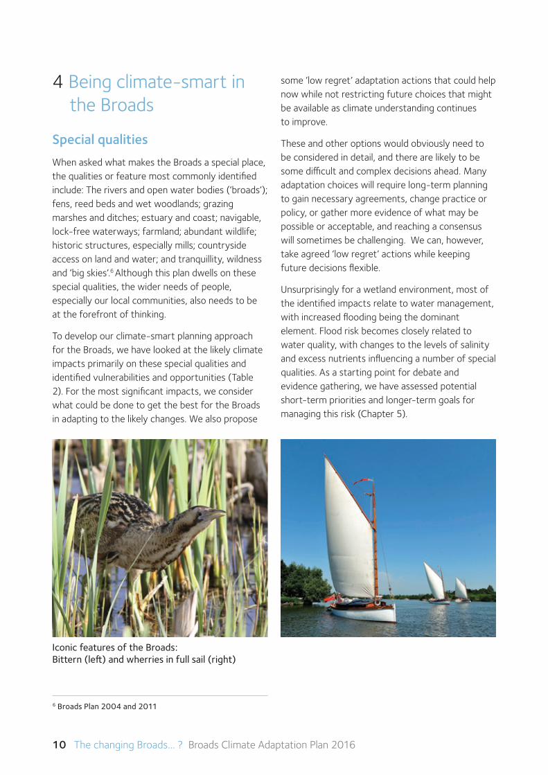
Iconic features of the Broads: Bittern (left) and wherries in full sail (right)
6 Broads Plan 2004 and 2011
The changing Broads... ? Broads Climate Adaptation Plan 2016 11
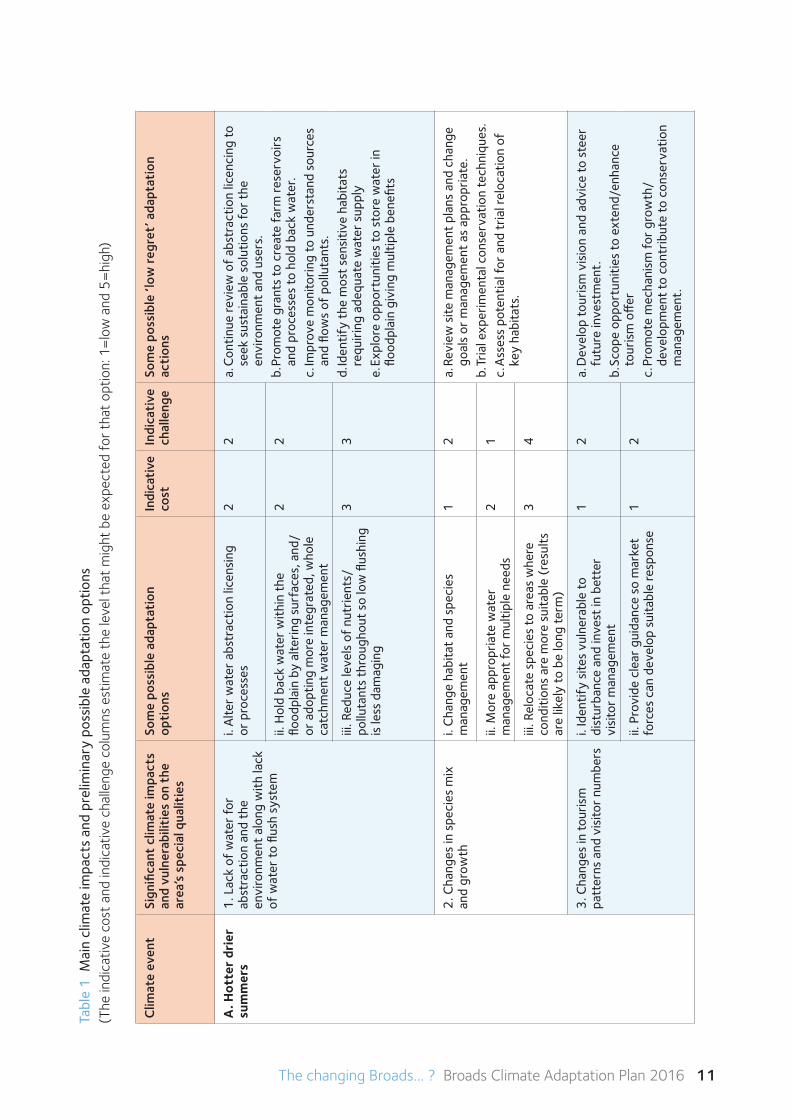
Tabl
e 1
Mai
n cl
imat
e im
pact
s an
d pr
elim
inar
y po
ssib
le a
dapt
atio
n op
tions
(T
he in
dica
tive
cost
and
indi
cativ
e ch
alle
nge
colu
mns
est
imat
e th
e le
vel t
hat
mig
ht b
e ex
pect
ed fo
r th
at o
ptio
n: 1
=lo
w a
nd 5
=hi
gh)
Clim
ate
even
tSi
gnifi
cant
clim
ate
impa
cts
and
vuln
erab
iliti
es o
n th
e ar
ea’s
spe
cial
qua
litie
s
Som
e po
ssib
le a
dapt
atio
n
opti
ons
Indi
cati
veco
stIn
dica
tive
chal
leng
eSo
me
poss
ible
‘low
regr
et’ a
dapt
atio
n
acti
ons
A. H
otte
r dr
ier
sum
mer
s1
. Lac
k of
wat
er fo
r
abst
ract
ion
and
the
en
viro
nmen
t al
ong
with
lack
of
wat
er to
flus
h sy
stem
i. A
lter
wat
er a
bstr
actio
n lic
ensi
ng
or p
roce
sses
22
a. C
ontin
ue re
view
of
abst
ract
ion
licen
cing
to
seek
sus
tain
able
sol
utio
ns fo
r th
e
envi
ronm
ent
and
user
s.
b. P
rom
ote
gran
ts to
cre
ate
farm
rese
rvoi
rs
and
proc
esse
s to
hol
d ba
ck w
ater
. c.
Impr
ove
mon
itorin
g to
und
erst
and
sour
ces
and
flow
s of
pol
luta
nts.
d. Id
entif
y th
e m
ost
sens
itive
hab
itats
re
quiri
ng a
dequ
ate
wat
er s
uppl
ye.
Exp
lore
opp
ortu
nitie
s to
sto
re w
ater
in
flood
plai
n gi
ving
mul
tiple
ben
efits
ii. H
old
back
wat
er w
ithin
the
flo
odpl
ain
by a
lterin
g su
rfac
es, a
nd/
or a
dopt
ing
mor
e in
tegr
ated
, who
le
catc
hmen
t w
ater
man
agem
ent
22
iii. R
educ
e le
vels
of
nutr
ient
s/
pollu
tant
s th
roug
hout
so
low
flus
hing
is
less
dam
agin
g
33
2. C
hang
es in
spe
cies
mix
an
d gr
owth
i. C
hang
e ha
bita
t an
d sp
ecie
s
man
agem
ent
12
a. R
evie
w s
ite m
anag
emen
t pl
ans
and
chan
ge
goal
s or
man
agem
ent
as a
ppro
pria
te.
b. Tr
ial e
xper
imen
tal c
onse
rvat
ion
tech
niqu
es.
c. A
sses
s po
tent
ial f
or a
nd t
rial r
eloc
atio
n of
ke
y ha
bita
ts.
ii. M
ore
appr
opria
te w
ater
m
anag
emen
t fo
r m
ultip
le n
eeds
21
iii. R
eloc
ate
spec
ies
to a
reas
whe
re
cond
ition
s ar
e m
ore
suita
ble
(res
ults
ar
e lik
ely
to b
e lo
ng te
rm)
34
3. C
hang
es in
tour
ism
pa
tter
ns a
nd v
isito
r nu
mbe
rsi.
Iden
tify
site
s vu
lner
able
to
dist
urba
nce
and
inve
st in
bet
ter
vi
sito
r m
anag
emen
t
12
a. D
evel
op to
uris
m v
isio
n an
d ad
vice
to s
teer
fu
ture
inve
stm
ent.
b.
Scop
e op
port
uniti
es to
ext
end/
enha
nce
tour
ism
off
erc.
Pro
mot
e m
echa
nism
for
grow
th/
de
velo
pmen
t to
con
trib
ute
to c
onse
rvat
ion
man
agem
ent.
ii. P
rovi
de c
lear
gui
danc
e so
mar
ket
forc
es c
an d
evel
op s
uita
ble
resp
onse
12
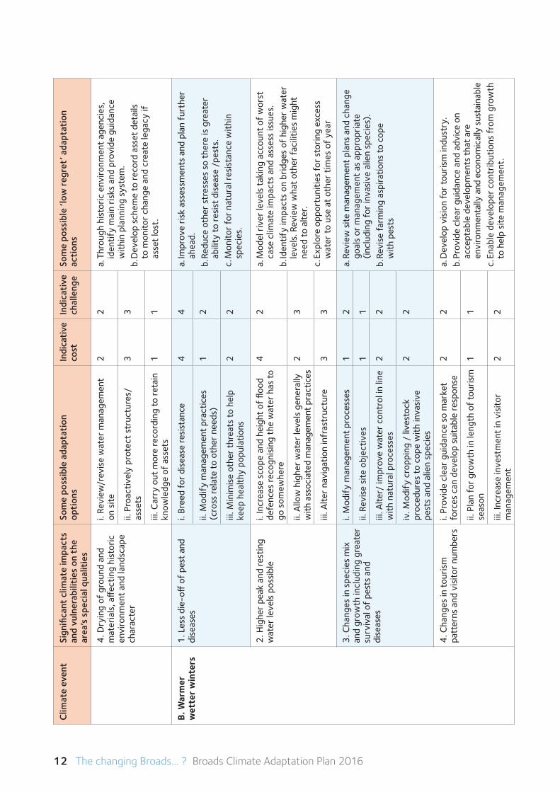
12 The changing Broads... ? Broads Climate Adaptation Plan 2016
Clim
ate
even
tSi
gnifi
cant
clim
ate
impa
cts
and
vuln
erab
iliti
es o
n th
e ar
ea’s
spe
cial
qua
litie
s
Som
e po
ssib
le a
dapt
atio
n
opti
ons
Indi
cati
veco
stIn
dica
tive
chal
leng
eSo
me
poss
ible
‘low
regr
et’ a
dapt
atio
n
acti
ons
4. D
ryin
g of
gro
und
and
mat
eria
ls, a
ffec
ting
hist
oric
en
viro
nmen
t an
d la
ndsc
ape
char
acte
r
i. Re
view
/rev
ise
wat
er m
anag
emen
t on
site
22
a. T
hrou
gh h
isto
ric e
nviro
nmen
t ag
enci
es,
iden
tify
mai
n ris
ks a
nd p
rovi
de g
uida
nce
with
in p
lann
ing
syst
em.
b. D
evel
op s
chem
e to
reco
rd a
sset
det
ails
to
mon
itor
chan
ge a
nd c
reat
e le
gacy
if
asse
t lo
st.
ii. P
roac
tivel
y pr
otec
t st
ruct
ures
/ as
sets
33
iii. C
arry
out
mor
e re
cord
ing
to re
tain
kn
owle
dge
of a
sset
s1
1
B. W
arm
er
wet
ter
win
ters
1. L
ess
die-
off o
f pe
st a
nd
dise
ases
i. Br
eed
for
dise
ase
resi
stan
ce4
4a.
Impr
ove
risk
asse
ssm
ents
and
pla
n fu
rthe
r ah
ead.
b. R
educ
e ot
her
stre
sses
so
ther
e is
gre
ater
ab
ility
to re
sist
dis
ease
/pe
sts.
c.
Mon
itor
for
natu
ral r
esis
tanc
e w
ithin
sp
ecie
s.
ii. M
odif
y m
anag
emen
t pr
actic
es
(cro
ss re
late
to o
ther
nee
ds)
12
iii. M
inim
ise
othe
r th
reat
s to
hel
p ke
ep h
ealth
y po
pula
tions
22
2. H
ighe
r pe
ak a
nd re
stin
g w
ater
leve
ls p
ossi
ble
i. In
crea
se s
cope
and
hei
ght
of fl
ood
defe
nces
reco
gnis
ing
the
wat
er h
as to
go
som
ewhe
re
42
a. M
odel
riv
er le
vels
taki
ng a
ccou
nt o
f w
orst
ca
se c
limat
e im
pact
s an
d as
sess
issu
es.
b. Id
entif
y im
pact
s on
brid
ges
of h
ighe
r w
ater
le
vels
. Rev
iew
wha
t ot
her
faci
litie
s m
ight
ne
ed to
alte
r.c.
Exp
lore
opp
ortu
nitie
s fo
r st
orin
g ex
cess
w
ater
to u
se a
t ot
her
times
of
year
ii. A
llow
hig
her
wat
er le
vels
gen
eral
ly
with
ass
ocia
ted
man
agem
ent p
ract
ices
23
iii. A
lter
navi
gatio
n in
fras
truc
ture
33
3. C
hang
es in
spe
cies
mix
an
d gr
owth
incl
udin
g gr
eate
r su
rviv
al o
f pe
sts
and
di
seas
es
i. M
odif
y m
anag
emen
t pr
oces
ses
12
a. R
evie
w s
ite m
anag
emen
t pl
ans
and
chan
ge
goal
s or
man
agem
ent
as a
ppro
pria
te
(inc
ludi
ng fo
r in
vasi
ve a
lien
spec
ies)
.b.
Rev
ise
farm
ing
aspi
ratio
ns to
cop
e
with
pes
ts
ii. R
evis
e si
te o
bjec
tives
11
iii. A
lter/
impr
ove
wat
er c
ontr
ol in
line
w
ith n
atur
al p
roce
sses
22
iv. M
odif
y cr
oppi
ng /
live
stoc
k
proc
edur
es to
cop
e w
ith in
vasi
ve
pest
s an
d al
ien
spec
ies
22
4. C
hang
es in
tour
ism
pa
tter
ns a
nd v
isito
r nu
mbe
rsi.
Prov
ide
clea
r gu
idan
ce s
o m
arke
t fo
rces
can
dev
elop
sui
tabl
e re
spon
se2
2a.
Dev
elop
vis
ion
for
tour
ism
indu
stry
. b.
Pro
vide
cle
ar g
uida
nce
and
advi
ce o
n
acce
ptab
le d
evel
opm
ents
tha
t ar
e
envi
ronm
enta
lly a
nd e
cono
mic
ally
sus
tain
able
c.
Ena
ble
deve
lope
r co
ntrib
utio
ns f
rom
gro
wth
to
hel
p si
te m
anag
emen
t.
ii. P
lan
for
grow
th in
leng
th o
f to
uris
m
seas
on1
1
iii. I
ncre
ase
inve
stm
ent
in v
isito
r
man
agem
ent
22
The changing Broads... ? Broads Climate Adaptation Plan 2016 13
Clim
ate
even
tSi
gnifi
cant
clim
ate
impa
cts
and
vuln
erab
iliti
es o
n th
e ar
ea’s
spe
cial
qua
litie
s
Som
e po
ssib
le a
dapt
atio
n
opti
ons
Indi
cati
veco
stIn
dica
tive
chal
leng
eSo
me
poss
ible
‘low
regr
et’ a
dapt
atio
n
acti
ons
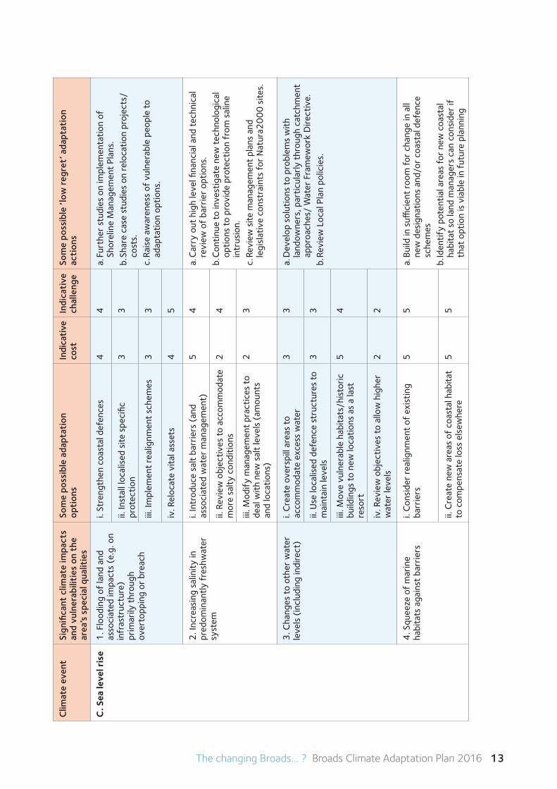
C. S
ea le
vel r
ise
1. F
lood
ing
of la
nd a
nd
asso
ciat
ed im
pact
s (e
.g. o
n in
fras
truc
ture
)
prim
arily
thr
ough
ov
erto
ppin
g or
bre
ach
i. St
reng
then
coa
stal
def
ence
s4
4a.
Fur
ther
stu
dies
on
impl
emen
tatio
n of
Sh
orel
ine
Man
agem
ent
Plan
s.
b. Sh
are
case
stu
dies
on
relo
catio
n pr
ojec
ts/
cost
s.
c. R
aise
aw
aren
ess
of v
ulne
rabl
e pe
ople
to
adap
tatio
n op
tions
.
ii. In
stal
l loc
alis
ed s
ite s
peci
fic
prot
ectio
n3
3
iii. I
mpl
emen
t re
alig
nmen
t sc
hem
es3
3
iv. R
eloc
ate
vita
l ass
ets
45
2. I
ncre
asin
g sa
linit
y in
pr
edom
inan
tly f
resh
wat
er
syst
em
i. In
trod
uce
salt
barr
iers
(an
d
asso
ciat
ed w
ater
man
agem
ent)
54
a. C
arry
out
hig
h le
vel fi
nanc
ial a
nd te
chni
cal
revi
ew o
f ba
rrie
r op
tions
. b.
Con
tinue
to in
vest
igat
e ne
w te
chno
logi
cal
optio
ns to
pro
vide
pro
tect
ion
from
sal
ine
intr
usio
n.
c. R
evie
w s
ite m
anag
emen
t pl
ans
and
le
gisl
ativ
e co
nstr
aint
s fo
r N
atur
a20
00
site
s.
ii. R
evie
w o
bjec
tives
to a
ccom
mod
ate
mor
e sa
lty
cond
ition
s2
4
iii. M
odif
y m
anag
emen
t pr
actic
es to
de
al w
ith n
ew s
alt
leve
ls (
amou
nts
and
loca
tions
)
23
3. C
hang
es to
oth
er w
ater
le
vels
(in
clud
ing
indi
rect
)i.
Cre
ate
over
spill
are
as to
ac
com
mod
ate
exce
ss w
ater
33
a. D
evel
op s
olut
ions
to p
robl
ems
with
la
ndow
ners
, par
ticul
arly
thr
ough
cat
chm
ent
appr
oach
es/
Wat
er F
ram
ewor
k D
irect
ive.
b. R
evie
w L
ocal
Pla
n po
licie
s.ii.
Use
loca
lised
def
ence
str
uctu
res
to
mai
ntai
n le
vels
33
iii. M
ove
vuln
erab
le h
abita
ts/h
isto
ric
build
ings
to n
ew lo
catio
ns a
s a
last
re
sort
54
iv. R
evie
w o
bjec
tives
to a
llow
hig
her
wat
er le
vels
22
4. S
quee
ze o
f m
arin
e ha
bita
ts a
gain
st b
arrie
rsi.
Con
side
r re
alig
nmen
t of
exi
stin
g ba
rrie
rs5
5a.
Bui
ld in
suffi
cien
t ro
om fo
r ch
ange
in a
ll ne
w d
esig
natio
ns a
nd/o
r co
asta
l def
ence
sc
hem
esb.
Iden
tify
pote
ntia
l are
as fo
r ne
w c
oast
al
habi
tat
so la
nd m
anag
ers
can
cons
ider
if
that
opt
ion
is v
iabl
e in
fut
ure
plan
ning
ii. C
reat
e ne
w a
reas
of
coas
tal h
abita
t to
com
pens
ate
loss
els
ewhe
re5
5
14 The changing Broads... ? Broads Climate Adaptation Plan 2016
Clim
ate
even
tSi
gnifi
cant
clim
ate
impa
cts
and
vuln
erab
iliti
es o
n th
e ar
ea’s
spe
cial
qua
litie
s
Som
e po
ssib
le a
dapt
atio
n
opti
ons
Indi
cati
veco
stIn
dica
tive
chal
leng
eSo
me
poss
ible
‘low
regr
et’ a
dapt
atio
n
acti
ons
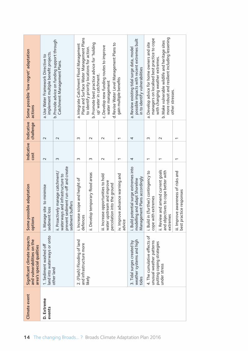
D. E
xtre
me
even
ts1
. Sed
imen
t w
ashe
d off
la
nd in
to w
ater
way
s or
ont
o ot
her
land
i. M
anag
e si
te t
o m
inim
ise
se
dim
ent
loss
22
a. U
se W
ater
Fra
mew
ork
Dire
ctiv
e to
im
plem
ent
mul
tiple
ben
efit
proj
ects
.b.
Pro
vide
adv
ice
on f
undi
ng s
uppo
rt t
hrou
gh
Cat
chm
ent
Man
agem
ent
Plan
s.
ii. P
roac
tivel
y m
anag
e ca
tchm
ent/
w
ater
way
s an
d in
fras
truc
ture
to
prev
ent
sedi
men
t ru
n-off
and
cre
ate
sedi
men
t bu
ffer
s
32
2. (
Flas
h) F
lood
ing
of la
nd
and
infr
astr
uctu
re m
ore
likel
y
i. In
crea
se s
cope
and
hei
ght
of
defe
nces
33
a. In
tegr
ate
Cat
chm
ent
Floo
d M
anag
emen
t Pl
ans
and
Surf
ace
Wat
er M
anag
emen
t Pl
ans
to id
entif
y pr
iorit
y lo
catio
ns fo
r ac
tion.
b.
Pro
mot
e be
st p
ract
ice
advi
ce fo
r ‘h
oldi
ng
up’ w
ater
in c
atch
men
t.c.
Dev
elop
new
fun
ding
rout
es to
impr
ove
wat
er m
anag
emen
td.
Rev
ise
Wat
er L
evel
Man
agem
ent
Plan
s to
ga
in m
ultip
le b
enefi
ts
ii. D
evel
op te
mpo
rary
floo
d ar
eas
32
iii. I
ncre
ase
oppo
rtun
ities
to h
old
w
ater
ups
trea
m a
nd im
prov
e
perc
olat
ion
into
the
gro
und
22
iv. I
mpr
ove
adva
nce
war
ning
and
ad
vice
11
3. T
idal
sur
ges
crea
ted
by
wea
ther
sys
tem
s an
d hi
gh
tides
i. Bu
ild p
oten
tial s
urge
ext
rem
es in
to
mod
ellin
g an
d ad
apt
Shor
elin
e
Man
agem
ent
Plan
s ac
cord
ingl
y
44
a. R
evie
w e
xist
ing
tidal
sur
ge d
ata,
mod
el
poss
ible
impa
cts
with
rece
nt e
xtre
mes
bui
lt in
to id
entif
y vu
lner
abili
ties
4. T
he c
umul
ativ
e eff
ects
of
unus
ual w
eath
er p
atte
rns
putt
ing
copi
ng s
trat
egie
s un
der
stre
ss
i. Bu
ild in
(fu
rthe
r) c
ontin
genc
y to
co
pe w
ith e
xtre
mes
13
a. D
evel
op a
dvic
e fo
r ho
me
owne
rs a
nd s
ite
man
ager
s on
loca
lised
bes
t pr
actic
e to
cop
e w
ith c
hang
ing
wea
ther
ext
rem
es.
b. M
ake
vuln
erab
le w
ildlif
e an
d he
ritag
e si
tes
mor
e ro
bust
and
resi
lient
incl
udin
g le
ssen
ing
othe
r st
ress
es.
ii. R
evie
w a
nd a
men
d cu
rren
t go
als
and
obje
ctiv
es to
cop
e be
tter
with
ex
trem
es
12
iii. I
mpr
ove
awar
enes
s of
ris
ks a
nd
best
pra
ctic
e re
spon
ses
11
The changing Broads... ? Broads Climate Adaptation Plan 2016 15
Conclusions
Water quality and quantity are central to the healthy functioning of the Broads ecosystems and the services they provide. From Table 1, it is suggested that the management of water will be central to many of the adaptation options and should be the priority for further investigation and planning as having the greatest significance for the special qualities. The largest risk relates to managing flooding. Other water related issues suggests an integrated, ‘big picture’ approach to water management is favourable. This would bring in consideration of drought conditions and water resources to meet competing demands.
The table also indicates that climate impacts can bring opportunities as well as risks. For example,
warmer drier summers may provide ideal opportunities for expansion of the tourism offer.
Changing temperatures, and especially a decline in very cold periods, may impact on issues such as the survival of pest and diseases. This may have significance for control of alien invasive species although the spread of such invasive species is not necessarily directly related to a changing climate. Issues such as heatwaves may have significant impacts on people’s health and adaptation options for buildings and settlements will become important. However, such approaches would have wider applicability than just the Broads.
This preliminary analysis does highlight the need to prioritise the risk of flooding and saline incursion and therefore in the next section we delve deeper into the adaptation options for this largest risk.
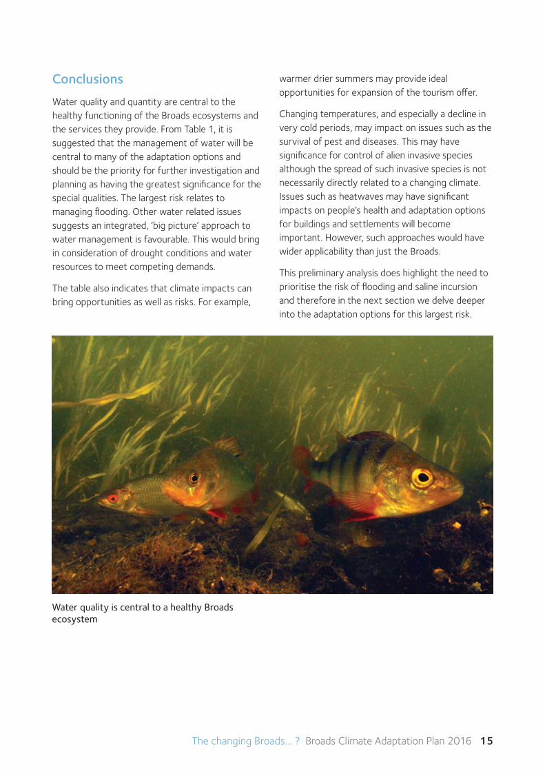
Water quality is central to a healthy Broads ecosystem
16 The changing Broads... ? Broads Climate Adaptation Plan 2016
5 Managingfloodrisk
Managingwaterresourcesisobviouslycentraltothe Broads wetland environment. With 95% of the Broads Authority Executive Area lying within the floodplain and its proximity to the coast, flood risk is a major issue. Flooding from changes in sea level, exacerbated by the impacts of climate change could substantially alter the current predominately freshwater system of the Broads.
The first draft Climate Adaptation Plan produced in 2011 suggested three broad adaptation scenarios to respond to the increased threat of flooding - ‘Business as usual’, ‘Seeking to control and restrain thewater’,and‘Makingspaceforwater’.Thesescenarios were used as part of the early public en-gagement through the Broads oCommunity project, to help people consider what they would prefer to see for the future of the Broads.
This engagement showed that there is very strong local debate about the importance of trying to maintain the Broads as a predominately freshwater system, how this could be achieved, and whether a point might be reached where it would become economically, environmentally or technically unfeasible to do so.
It is recognised that choices about flood risk adaptation will be central to the future of the Broads and the more detailed adaptation choices to be pursued. As a starting point for debate, we have made a high level assessment for managing flood risk, using the steps in the climate-smart planning cycle.
Planning purpose and scope
• To identify flood risk adaptation options for the Broads within the wider context of the rivers catchment, coast, and urban and rural surrounds
• To evaluate adaptation options against desired goals, objectives and strategies.
Climate impacts and vulnerabilities
• The sea overtopping or breaching defences and/or surging up the rivers
• Squeeze of coastal habitat as it becomes eroded by the sea and cannot move past existing barriers
• Excessive rain, which may also be held back by the tide, overtopping and breaching defences
• Ground and surface water flooding
• Extreme weather events in combination (such as storms with high tides and heavy rainfall) affecting how defences cope with the situation (such as existing flood walls).
• Loss of river habitats due to changing water levels
The likely impacts on the area’s special qualities include:
• Flooding threats to life, property and infrastructure
• Increased pollutants and excess nutrients, sediments and salinity in the rivers and broads
• Greater pressures on water resources
• Loss of coastal habitat
• Loss of river habitats
• Changes in the distribution, mix and growth of species
• Changes in visual landscape character, including archaeological and built heritage features
• Changes in agricultural patterns and production
• Changes in tourism patterns and visitor numbers
Current goals, objectives and strategies
A range of bodies have roles and responsibilities for managing flood risk in the Broads and along the Norfolk and Suffolk coast. The Broads Authority manages the Broads for conservation, recreation
The changing Broads... ? Broads Climate Adaptation Plan 2016 17
and navigation. As the local planning authority it controls development in the area (primarily in the flood plain) and advises on matters such as sustainable building design.
The Environment Agency manages flood risk from the main rivers, estuary and the sea, and is responsible for river and tidal flood defences. Norfolk and Suffolk County Councils are the Lead Local Flood Authorities, managing flood risk from surface water, ordinary watercourses and groundwater. Water and sewerage companies manage the risk of flooding to water supply and sewerage facilities and the risk to others from the failure of their infrastructure, and Internal Drainage Boards manage land drainage in lowland areas. These organisations also have a role to play in encouraging communities to participate in flood risk management at their local level.
Moredetailsabouttheserolesandresponsibilitiesare set out in the appendices.
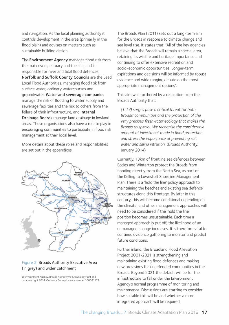
© Environment Agency. Broads Authority © Crown copyright and database right 2014. Ordnance Survey Licence number 100021573
Figure 2 Broads Authority Executive Area (in grey) and wider catchment
The Broads Plan (2011) sets out a long-term aim for the Broads in response to climate change and sea level rise. It states that: “All of the key agencies believe that the Broads will remain a special area, retaining its wildlife and heritage importance and continuing to offer extensive recreation and socio-economic opportunities. Longer-term aspirations and decisions will be informed by robust evidence and wide ranging debate on the most appropriate management options”.
This aim was furthered by a resolution from the Broads Authority that:
(Tidal) surges pose a critical threat for both Broads’ communities and the protection of the very precious freshwater ecology that makes the Broads so special. We recognise the considerable amount of investment made in flood protection and stress the importance of preventing salt water and saline intrusion. (Broads Authority, January 2014)
Currently, 13km of frontline sea defences between Eccles and Winterton protect the Broads from flooding directly from the North Sea, as part of theKellingtoLowestoftShorelineManagementPlan. There is a ‘hold the line’ policy approach to maintaining the beaches and existing sea defence structures along this frontage. By later in this century, this will become conditional depending on the climate, and other management approaches will need to be considered if the ‘hold the line’ position becomes unsustainable. Each time a managed approach is put off, the likelihood of an unmanaged change increases. It is therefore vital to continue evidence gathering to monitor and predict future conditions.
Further inland, the Broadland Flood Alleviation Project 2001-2021 is strengthening and maintaining existing flood defences and making new provisions for undefended communities in the Broads. Beyond 2021 the default will be for the infrastructure to fall under the Environment Agency’s normal programme of monitoring and maintenance. Discussions are starting to consider how suitable this will be and whether a more integrated approach will be required.
18 The changing Broads... ? Broads Climate Adaptation Plan 2016
Possible adaptation options
As a starting point for further debate and evidence building, we have looked at seven possible adaptation responses to flood risk (Table 2).
Table 2 Assessing adaptation options for managing flood risk in the Broads
Possible adaptation options Considerations
a Make incremental additions to existing flood protection as conditions dictate. May be achieved through management change (e.g. altering the levels and uses of sluices) but more likely to require technological/ built solutions to maintain current situation.
May initially appear lower cost option but as each incremental cost is added may become high cost over time, which could mask underlying increase in risks and be false economy.
Many experts believe ‘business as usual’ approach would not provide necessary risk management. Changing conditions may create very technical challenges and require increasingly complex solutions.
Creates potential for increasing inequality as poor and small communities receive less favourable solutions.
b Accept there will be increased fresh and salt water flooding leading to (slow) change of freshwater habitat to brackish and saline, coastal habitat squeeze, increased impacts on and constraints to riverside economy and recreation. Minimise threat to life and property through advanced warning systems.
Dwells on unmanaged change. Unlikely to be acceptable option to local people, visitors and, to certain degree, current legislation as planned approaches should bring wider benefits.
Response to change Change themanagement
Change the technology
Relocate assets
Take no action
Resist change, make alterations to keep things same
a
Accept change, make no alterations b
Accept change, make alterations to get best from situation
c d e
Accept change, alter goals/strategies/ objectives
f g
Key to Table 2
The changing Broads... ? Broads Climate Adaptation Plan 2016 19
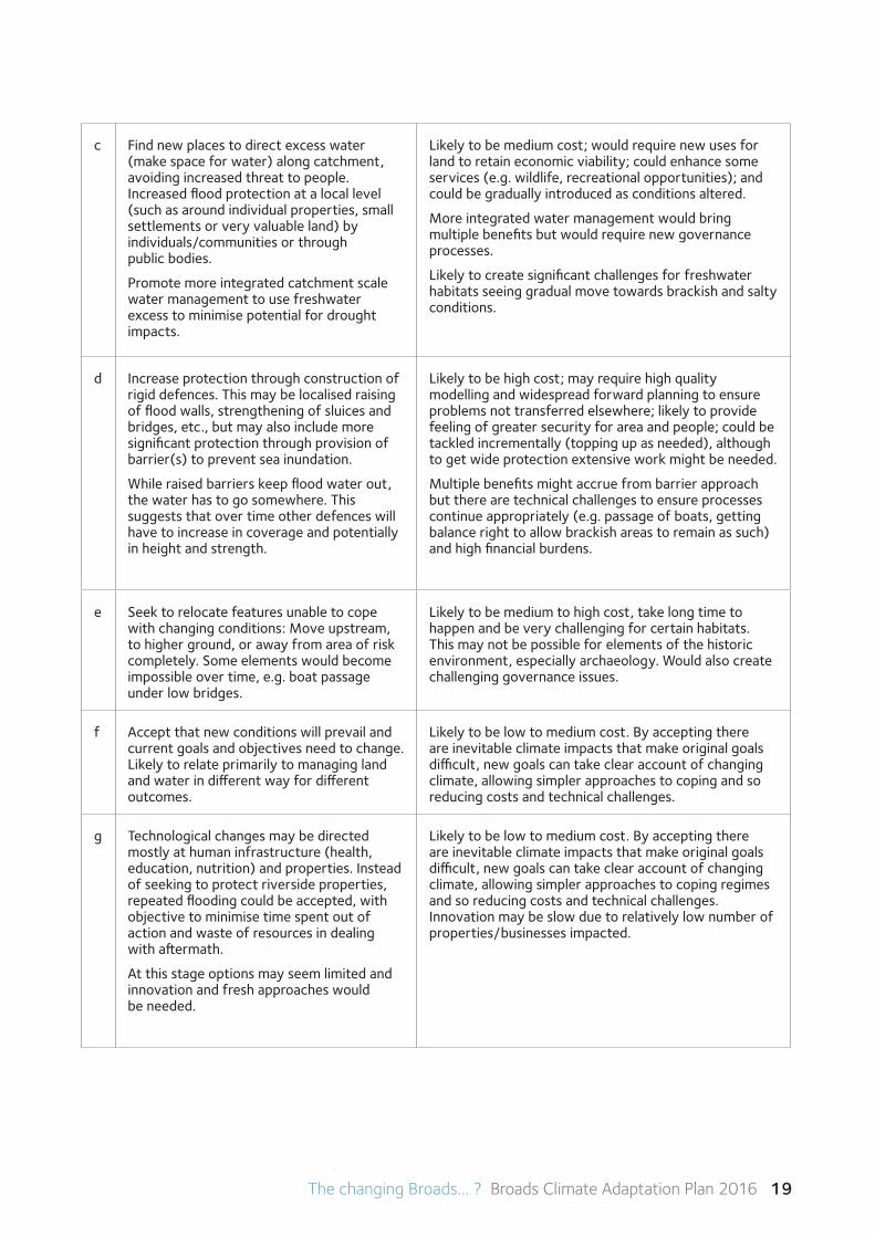
c Find new places to direct excess water (make space for water) along catchment, avoiding increased threat to people. Increased flood protection at a local level (such as around individual properties, small settlements or very valuable land) by individuals/communities or through public bodies.
Promote more integrated catchment scale water management to use freshwater excess to minimise potential for drought impacts.
Likely to be medium cost; would require new uses for land to retain economic viability; could enhance some services (e.g. wildlife, recreational opportunities); and could be gradually introduced as conditions altered.
More integrated water management would bring multiple benefits but would require new governance processes.
Likely to create significant challenges for freshwater habitats seeing gradual move towards brackish and salty conditions.
d Increase protection through construction of rigid defences. This may be localised raising of flood walls, strengthening of sluices and bridges, etc., but may also include more significant protection through provision of barrier(s) to prevent sea inundation.
While raised barriers keep flood water out, the water has to go somewhere. This suggests that over time other defences will have to increase in coverage and potentially in height and strength.
Likely to be high cost; may require high quality modelling and widespread forward planning to ensure problems not transferred elsewhere; likely to provide feeling of greater security for area and people; could be tackled incrementally (topping up as needed), although to get wide protection extensive work might be needed.
Multiple benefits might accrue from barrier approach but there are technical challenges to ensure processes continue appropriately (e.g. passage of boats, getting balance right to allow brackish areas to remain as such) and high financial burdens.
e Seek to relocate features unable to cope with changing conditions: Move upstream, to higher ground, or away from area of risk completely. Some elements would become impossible over time, e.g. boat passage under low bridges.
Likely to be medium to high cost, take long time to happen and be very challenging for certain habitats. This may not be possible for elements of the historic environment, especially archaeology. Would also create challenging governance issues.
f Accept that new conditions will prevail and current goals and objectives need to change. Likely to relate primarily to managing land and water in different way for different outcomes.
Likely to be low to medium cost. By accepting there are inevitable climate impacts that make original goals difficult, new goals can take clear account of changing climate, allowing simpler approaches to coping and so reducing costs and technical challenges.
g Technological changes may be directed mostly at human infrastructure (health, education, nutrition) and properties. Instead of seeking to protect riverside properties, repeated flooding could be accepted, with objective to minimise time spent out of action and waste of resources in dealing with aftermath.
At this stage options may seem limited and innovation and fresh approaches would be needed.
Likely to be low to medium cost. By accepting there are inevitable climate impacts that make original goals difficult, new goals can take clear account of changing climate, allowing simpler approaches to coping regimes and so reducing costs and technical challenges. Innovation may be slow due to relatively low number of properties/businesses impacted.
20 The changing Broads... ? Broads Climate Adaptation Plan 2016
Evaluating and selecting adaptation options
We would clearly need more information and stakeholder discussion to evaluate these and other options in depth. However, a simple analysis suggests that option (b), take no action, would be unacceptable to most people and goes against current legislation. The general consensus is that ‘business as usual’ is not a sound or cost effective approach as the rate and scale of changes will become more rapid and ‘post event’ reactions too demanding.Manyoftheotheroptionsappeartohave high costs and can be technically challenging. It would appear wise to explore in greater detail whether such costs can be reduced, and identify ways of tackling technical issues. Revising current goals or policies may have merit, provided adaptation actions for one requirement would not worsen impacts on something of equal or greater value. Short-term ‘low-regret’ actions to retain the existing special features of the Broads may be preferable, where these would not have unacceptable costs or adverse knock-on effects, or severely restrict future adaptation choices.
Our conclusion from this preliminary exercise would be to seek to retain the freshwater elements of the Broads for the time being, in line with current policy. At the same time, we would need to apply ‘climate-smart’ thinking to planning and major investment, and improve our knowledge about adaptive choices that could balance costs and benefits and retain the Broads as a special place – although we may have to accept that one or more of the special qualities may not be the same.
The previous research on engineered barriers would need to be revisited to understand the technical and financial options relating to current modelling. If there are realistic engineering solutions, seeking the necessary finance and permissions will take time. If the solutions are not practicable or affordable, efforts can be directed at finding alternatives. Implementing short-term ‘low regret’ projects will help inform longer-term approaches. We also need to identify what data needs to be collected to improve our understanding.
6 Consultation processTo test the emerging views in the draft Climate Adaptation Plan, consultation was undertaken with local stakeholders from mid-July to mid-September 2015. Due to elements such as complexity and uncertainty about climate change, the Broads Climate Partnership agreed to produce a summary document of the full plan, written and designed to be more attractive to read. This was posted on the Authority’s website and promoted to a wide range of stakeholders on the Authority’s consultation database. This included all parish councils and members of committees and forums organised by the Broads Authority such as the statutory Local Access Forum and the Broads Forum of representatives from interest groups in the Broads. People were invited to comment on the draft summary or draft full plan.
The draft plans were also promoted through social media (e.g. BA and Broads OCommunity twitter accounts, Facebook and blogs), directing people to the host website. We also offered to attend any relevant meetings of stakeholder organisations in the consultation period.
14 consultation responses were received, and these are summarised in the appendices. The Broads Climate Partnership made recommendations for changes to the plans, and these were submitted to the Broads Authority in November 2015. Both the full and summary plans were revised in the light of the consultation.
The summary from the responses was that:
• The subject of climate change and sea level rise is complex and communities are still not clear how it really relates to their everyday lives.
• It is important to ensure that impacts and actions encompass people as well as the environment and that the network of environmental assets is considered.
• There is a general desire for more specific detail on what was actually going to happen, as there was a need for a bold and clear plan of action.
The changing Broads... ? Broads Climate Adaptation Plan 2016 21
• The importance of managing water holistically, including exploring the implications and possible actions regarding saline incursion, was supported.
• The climate-smart approach was supported.
• The initial analysis around flood risk and sea level rise was supported.
From this, the following tenets were approved:
A. A climate-smart approach should be promoted to stakeholders in the Broads.
B. Stakeholders should work together to develop integrated responses to a changing climate. This will grow in importance to ensure sector actions do not develop unintended adverse impacts elsewhere.
C. There is a need to increasingly seek a holistic approach to water management and to embed understanding on how critical good water care is for the Broads.
D. Future iterations of the Broads Plan should be used to express the aspirational and guiding strategic approach to get the best for the Broads from a changing climate. However some more detailed and specific plans to take integrated action and make a difference are also needed.
7 Next stepsThe following actions have emerged from the recommendations of the Broads Climate Partnership:
Documents: The revised full and summary versions of the Climate Adaptation Plans will be submitted to Defra as a voluntary contribution to the Adaptation Reporting Powers (ARP) approach.
Interpretation: Improve public awareness and understanding of the implications of a changing climate for the Broads to enable people to have more confidence to take a climate-smart approach, assess their own vulnerabilities and plan ahead to use the need to change to their advantage. This can be tackled in three ways:
A. Broads Plan and other strategies/plans: Preparation of Broads Plan 2017 enables climate change issues to be embedded in the document and demonstrate how adaptation planning is part of forward planning. There may be a need to scope a statement of intent to support future holistic water management across the Broads, and to develop evidence about integrated adaptation changes to retain the special qualities of the Broads.
B. Use protected landscape adaptation actions to influence behavioural change in others: A project to interpret climate change action in the Broads and other protected landscapes to inform visitors and influence their behaviour at a community level needs to be devised. This will require external funding, initially at a pilot scale, with the intention of rolling it out to other National Parks and AONBs.
C. Support interested priority stakeholders (farmers, tourism businesses, parish councils and young adults) to develop good practice examples of climate-smart assessments and actions to share with others.
Saline incursion: The risk of more salt coming into the Broads’ system remains, and further work is needed to consider what can be done. Two initial strands of work will be developed:
22 The changing Broads... ? Broads Climate Adaptation Plan 2016
A. The Broads Authority is supporting a new PhDstudy at UEA / Tyndall Centre modelling longer-term (20 years+) impacts of a changing climateand rising sea level and how this affects flood riskand saline incursion. The study will also include asocial science element considering the responseto the modelling by communities andstakeholders – i.e. does it improveunderstanding and confidence to act? This in turncan inform the process of building stakeholderagreement on future approaches.
B. The Climate Change Partnership will press theEnvironment Agency to revisit their work onflood barriers to update understanding ontechnical feasibility and financial implications. Thisshould give more clarity on options for retaininga predominately freshwater system for as long aspossible and allow a more open discussion withlocal and national interests.
Partnership working: There is a strong need to continue to work in partnership to develop common, shared approaches to climate adaptation.
The Climate Change Adaptation Panel will become known as the Broads Climate Partnership. It will retain flexibility on who is invited to join and participate, primarily retaining high level representation. It will also:
• Identifykeyorganisationsandgroupsabletosupport differing elements in an action plan, andwill invite such involvement.
• Seektostrengthenlinkstoacademiaandencourage new research and the developmentof scenarios for how the Broads might adapt tochanging circumstances.
• EncouragetheBroadlandRiversCatchmentPartnership and the various (and evolving) coastalpartnerships to realistically take account of theclimate vulnerabilities of the Broads and developresilience and adaptation responses.
• WorkcloselywiththeEnvironmentAgencytoundertake effective debate with Broads’communities and other interestedstakeholders about longer-term flood riskmanagement options as the Broads FloodAlleviation Project comes towards its conclusion(post-2021).
To support these aims we have set up the Broads oCommunity initiative, to involve everyone with an interest in the Broads in discussing and planning for a climate resilient future.
If you would like further help with your own climate-smart approach or have ideas to share with the Broads oCommunity, please get in touch.
Write to Broads oCommunity c/o Broads Authority 62-64 Thorpe RoadNorwich NR1 1RY
Email [email protected]
Visit the web site www.broads-authority.gov.uk/looking-after/ climate-change where you can also find the summary and full Broads Climate Adaptation Plan
Join the debate
The changing Broads... ? Broads Climate Adaptation Plan 2016 23
Appendix A The Potential Impacts of Climate Change on the Norfolk Broads (extracts)
In the original 2003 report, the Broads was examined as an entire catchment basin and the climate changes considered were only provided for the 2080s and for only two seasons. The new report expanded on the 2003 report by looking at seventeen climate model patterns, monthly, for three time periods (2020s, 2010-2039; 2050s, 2040-2069; 2080s, 2070-2099), for the four latest IPCC scenarios (the Representative Concentration Pathways [RCP 3PD, 4.5, 6 and 8.5]), for minimum, average, and maximum temperature, total monthly precipitation, wet day frequency, cloud cover and sea-surface temperature (for a single 0.5° x 0.5° grid cell). A further analysis derived potential changes in water temperature based on changes in air temperature.
The results of these analyses are described in the main report for a single emission scenario and a single grid cell covering much of the northern Broads. Graphs providing the terrestrial climate information for all four of the 0.5° x 0.5° grid cells covering the Broads, and for all four of the RCP scenarios can be found in an extensive annex. The information presented in the report is provided as changes from a 1961-1990 observed climate (CRU TS2.1) in tabular format, and in graphs summarizing the absolute values, and depicting the range of values for the seventeen climate model patterns. Finally, a summary of potential impacts on terrestrial biodiversity in the Broads region, using fewer models and slightly different emission scenarios (the UK Government AVOID scenarios) is included after the sections describing the climate changes (Price, Warren and Vanderwal, 2013).
The conclusions from the report can be summarised as:
2.1 Average maximum temperature
The average monthly maximum temperature is projected to increase, on average, by 0.94°C by the 2020s, 2.1°C by the 2050s, and 3.5°C by the 2080s. Temperature increases are projected to be slightly greater in the period July-October than the rest of the year. The greatest projected change is an increase of >4°C in August/September in the 2080s (range 2.0° - 6.3°). For the 2050s this translates to an average August maximum temperature of 23°C (compared to just over 20°C 1961-1990) and an average August maximum temperature of 24.5°C by the 2080s.
2.2 Average monthly temperature
The average monthly temperature is projected to increase, on average, by 0.92°C by the 2020s, 2.03°C by the 2050s, and 3.4°C by the 2080s. Temperature increases are projected to be slightly greater in the period July-October than the rest of the year. The greatest projected change is an increase of >4°C in August/September in the 2080s (range 1.8° - 6.1°). For the 2050s this translates to an average August temperature of 18.5°C (compared to just over 16°C 1961-1990) and an average August temperature of just over 20°C by the 2080s – thus an average August temperature similar to the current (1961-1990) average maximum temperature.
2.3 Average minimum temperature
The average monthly minimum temperature is projected to increase, on average, by 0.9°C by the 2020s, 2.0°C by the 2050s, and 3.3°C by the 2080s. Temperature increases are projected to be slightly greater in the period July-October than the rest of the year. The greatest projected change is an increase of 3.9°C in August/September in the 2080s(range1.7°-5.9°).Moreimportantlyarethe temperature increases in winter months. For the 2050s this translates to an average minimum winter temperature of 3.5-4°C (compared to just over 1-2°C 1961-1990) and an average minimum winter temperature of 4.5 – 5.5°C by the 2080s. Thus, by the 2080s, the average winter minimum temperatures will be similar to the April temperatures of 1961-1990.
Join the debate
24 The changing Broads... ? Broads Climate Adaptation Plan 2016
2.4 Average precipitation
The average monthly precipitation is projected to increase, on average, by 0.2 mm by the 2020s, 0.62 mm by the 2050s, and 1.4 mm by the 2080s. However, this is only part of the story. The climate models are reasonably consistent with almost all showing a wetter winter, and all but two showing a drier summer. The precipitation increases in winter are projected to be on the order of 5-8 mm by the 2050s and 8-13 mm by the 2080s. The precipitation decreases in summer (July- Sept) are projected to be on the order of 7-9 mm by the 2050s and 10-13.7 mm by the 2080s.
2.5 Average wet day frequency
Wet days are defined as days receiving more than 0.1 mm of precipitation. The average monthly wet day frequency is projected to undergo no change by the 2020s and 2050s, and increase only slightly (0.1 days) by the 2080s. However, as with precipitation, this is only part of the story. The climate models are reasonably consistent with almost all showing more wet days in winter, and all but two showing fewer wet days in August. The number of wet days in winter is projected to increase by 0.7-1 by the 2050s and 1.2-1.6 by the 2080s. The number of wet days in summer is projected to decline by 0.9-1.2 (July-Sept) by the 2050s and 1.4-1.9 by the 2080s.
2.6 Average cloud cover
The overall average monthly cloud percentage is projected to undergo only slight changes (-0.76%, -1.72%, -2.9% by the 2020s, 2050s, and 2080s respectively). However, as with precipitation and wet day frequency, this is only part of the story. The climate models are reasonably consistent, showing little change in cloudiness in winter and spring, potentially large decreases in summer and lesser decreases in the autumn.
2.7 Change in average temperature of rivers (derived)
While river temperatures are not calculated in climate models it is possible to estimate the potential change in river temperature from
average air temperature using an equation originally derived from examining the relationship between air and stream temperature for hundreds of locations globally. There are many factors ultimately influencing river temperature, including shading, rate of flow, and mixing with tidal waters. Thus, these estimates should be viewed as first approximations only. The overall change in average monthly river temperature is projected to be an increase of 1.9°C in the 2050s (range 0.95° - 2.8°C) and 3°C in the 2080s (range 1.7° - 4.8°C). The greatest temperature increase is projected for the August-September period (2.6°C in the 2050s, 4.2°C in the 2080s but potentially greater than 5°C warmer). Overall, increases in winter river temperature are not as pronounced.
2.8 Change in average sea surface temperature
The average monthly sea surface temperature (SST) change was looked at for the coastal region offshore of Great Yarmouth and north. This analysis uses slightly different data series and time frames. The overall change is projected to be an increase of 0.9°C in the 2020s, 1.9°C in the 2050s and 3.2°C in the 2080s. The greatest temperature increase is projected for the July-October period (2.1°C in the 2050s, 3.5°C in the 2080s but potentially greater than 5°C warmer).
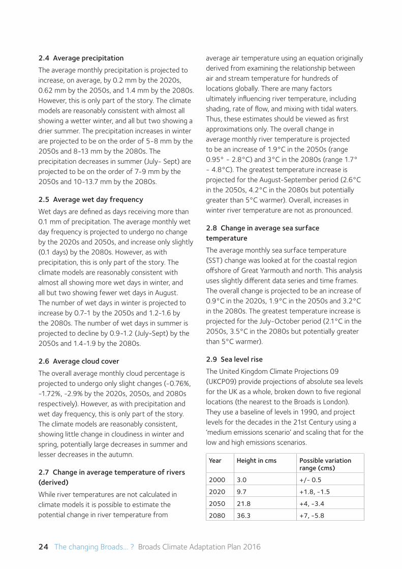
2.9 Sea level rise
The United Kingdom Climate Projections 09 (UKCP09) provide projections of absolute sea levels for the UK as a whole, broken down to five regional locations (the nearest to the Broads is London). They use a baseline of levels in 1990, and project levels for the decades in the 21st Century using a ‘medium emissions scenario’ and scaling that for the low and high emissions scenarios.
Year Height in cms Possible variation range (cms)
2000 3.0 +/- 0.5
2020 9.7 +1.8, -1.5
2050 21.8 +4, -3.4
2080 36.3 +7, -5.8
The changing Broads... ? Broads Climate Adaptation Plan 2016 25
2.10 Extreme events
Recent experience has suggested that there may also be changes in extreme events with a greater frequency and a higher intensity. This is perhaps implied from the information above, where there is likely to be greater monthly average precipitation but limited change in the number of wet days. As yet there are limited projections on what those changes might be.
2.11 Confidence levels
The 2013 report also identified that, while there was still uncertainty in the projections, the models’ results were more similar than in 2003, with smaller data spreads. It will be important to revisit the data as the modelling improves and the observed trends are matched to the modelling. However, the information does help identify the types of climate change that can be matched to the special qualities of the Broads in order to assess likely impacts and implications.
2.12 Alternative viewpoints
These projections are based on the interpretation of only part of a vast range of data and interactions. It therefore follows that it may be possible to reach differing assessments of impacts, scales or timing. However, the Climate Change Adaptation Panel considers this interpretation to be robust, appropriate and useful, helping more effective forward planning to be developed while recognising that flexibility will always be needed.
Complete details on the models and methods used may be found in the full report:
The Potential Impacts of Climate Change on the Norfolk Broads (Price, Tyndall Centre, UEA, 2013)
Appendix B Managingfloodrisk:Rolesand responsibilities
A range of bodies have responsibilities for managing flood risk in the UK, with the Government as lead body and policy maker. The role of each body is shown below.
Government
The Department for Environment, Food and Rural Affairs (Defra) and the Welsh Government develop Flood and Coastal Environment Risk Management(FCERM)policyandaretheleadsfor flood and coastal erosion risk management in England and Wales. New or revised policies are prepared with other parts of government such as the Treasury, the Cabinet Office (for emergency response planning) and the Department for Communities and Local Government (for land-use and planning policy). These national policies then form the basis of the Environment Agency’s and lead local flood authorities’ work.
Environment Agency
With its national role, the Environment Agency has a strategic overview of all sources of flooding and coastal erosion (as defined in the Flood and Water ManagementAct-FWMA).Itisalsoresponsiblefor flood and coastal erosion risk management activities on main rivers and the coast, regulating reservoir safety, and working in partnership with theMetOfficetoprovidefloodforecastsandwarnings. It must also look for opportunities to maintain and improve the environment for people and wildlife while carrying out all of its duties.
The Environment Agency’s work includes:
•Developinglong-termapproachestoFCERM.This includes working with others to prepare and carry out sustainable Catchment Flood ManagementPlans(CFMPs)andShoreline ManagementPlans(SMPs).CFMPsaddressfloodriskineachrivercatchment.SMPsassesstherisks of coastal flooding and erosion and propose
26 The changing Broads... ? Broads Climate Adaptation Plan 2016
ways to manage them. The Environment Agency also collates and reviews assessments, maps and plans for local flood risk management (normally undertaken by lead local flood authorities (LLFAs)).
•Providingevidenceandadvicetosupportothers.This includes national flood and coastal erosion risk information, data and tools to help other risk management authorities and inform Government policy, and advice on planning and development issues.
•Workingwithotherstoshareknowledgeandthe best ways of working. This includes work to developFCERMskillsandresources.
•Monitoringandreportingonfloodandcoastalerosion risk management. This includes reporting onhowthenationalFCERMstrategyishavinganimpact across the country.
•Somedesignandconstructionofseadefences.
Lead local flood authorities (LLFAs)
LLFAs are county councils and unitary authorities. UndertheFWMA,LLFAsarerequiredto:
•Prepareandmaintainastrategyforlocalfloodrisk management in their areas, coordinating views and activity with other local bodies and communities through public consultation and scrutiny, and delivery planning.
•Maintainaregisterofassets–thesearephysicalfeatures that have a significant effect on flooding in their area.
•Investigatesignificantlocalfloodingincidentsandpublish the results of such investigations
•Establishapprovalbodiesfordesign,buildingand operation of Sustainable Drainage Systems (SuDS)
• Issueconsentsforaltering,removingorreplacingcertain structures or features on ordinary watercourses
•Playaleadroleinemergencyplanningand recovery after a flood event.
LLFAs and the Environment Agency will need to work closely together and ensure that the plans they are making both locally and nationally link up. An essential part of managing local flood risk will be taking account of new development in any plans or strategies.
If a flood happens, all local authorities are ‘category one responders’ under the Civil Contingencies Act. This means they must have plans in place to respond to emergencies, and control or reduce the impact of an emergency. LLFAs also have a new duty to determine which risk management authorities have relevant powers to investigate flood incidents to help understand how they happened, and whether those authorities have or intend to exercise their powers.
By working in partnership with communities, LLFAs can raise awareness of flood and coastal erosion risks. Local flood action groups (and other organisations that represent those living and working in areas at risk of flooding) will be useful and trusted channels for sharing up-to-date information, guidance and support direct with the community.
LLFAs should encourage local communities to participate in local flood risk management. Depending on local circumstances, this could include developing and sharing good practice in risk management, training community volunteers so that they can raise awareness of flood risk in their community, and helping the community to prepare flood action plans. LLFAs must also consult local communities about its local flood risk management strategy.
District and Borough Councils
Currently much of the capacity, capability and staff resource (especially with experience and knowledge of land drainage and flooding) is within other Risk ManagementAuthorities(RMAs)atDistrictandBorough Councils. These organisations currently perform a significant amount of work relating to flood risk management, and this is likely to continue into the future as these local authorities workcloselywiththeLLFAsandotherRMAs.
The changing Broads... ? Broads Climate Adaptation Plan 2016 27
Coastal erosion risk management authorities
Coastal local authorities work alongside the Environment Agency to develop and maintain coastal flood and erosion risk information. This will contribute to national information maintained by the Environment Agency and promote understanding of these risks. This will enable them to be taken into account in planning how to protect and manage the coast.
Water and sewerage companies
Water companies play a role in managing flood and coastal erosion risks. They manage the risk of flooding to water supply and sewerage facilities and the risk to others from the failure of their infrastructure.
The main roles of water and sewerage companies in managing flood and coastal erosion risks are to:
• makesuretheirsystemshavetheappropriatelevel of resilience to flooding, and maintainessential services during emergencies
• maintainandmanagetheirwatersupplyandsewerage systems to manage the impact andreduce the risk of flooding and pollution to theenvironment
• workwithdevelopers,landownersandLLFAstounderstand and manage risks – for example, byworking to manage the amount of rainfall thatenters sewerage systems
Where there is frequent and severe sewer flooding, (sites included on the DG5 Register) sewerage undertakers are required to address this through their capital investment plans, which are regulated by Ofwat.
Water UK represents all UK water and wastewater service suppliers at national and European level. It provides a framework for the water industry to engage with government, regulators, stakeholder organisations and the public.
Internal Drainage Boards (IDBs)
IDBs have an important role to play in flood risk management, and in creating and managing natural habitats. Each IDB operates within a defined area, known as a drainage district. They are made up of elected members who represent land occupiers, and others nominated by local authorities who represent the public and other interest groups.
IDBs are independent public bodies responsible for managing water levels in low-lying areas. They are the land drainage authority within their districts and their functions include supervising land drainage and flood defence works on ordinary watercourses. This is primarily funded by drainage rates and levies from land occupiers and local authorities. By doing this, they closely manage water levels, both in watercourses and underground (groundwater), by improving and maintaining ordinary watercourses, drainage channels and pumping stations to reduce the risk of flooding.
They are able to involve local people, encourage volunteering and raise funds from those who benefit from their work.
Highways authorities
Highways authorities (the Highways Agency and unitary/county councils) have the lead responsibility for providing and managing highway drainage and roadside ditches under the Highways Act 1980. The owners of land adjoining a highway also have a common-law duty to maintain ditches to prevent them causing a nuisance to road users.
To manage these risks as set out in the national strategy, highways authorities will need to work effectively with the Environment Agency, LLFAs and district councils to ensure their flood management activities are well coordinated.
Information taken from the Local Government Association website (http://www.local.gov.uk)
28 The changing Broads... ? Broads Climate Adaptation Plan 2016
Other key organisations
Broads Authority
The Broads Authority has a duty to manage the Broads for the purposes of conserving and enhancing the natural beauty, wildlife and cultural heritage of the Broads; promoting opportunities for the understanding and enjoyment of the special qualities of the Broads by the public; and protecting the interests of navigation. It must also have regard to the needs of agriculture and forestry and the economic and social interests of those who live or work in the Broads. The Authority is the local planning authority for the Broads Executive Area, and advises developers and planning applicants on sustainable building design and on development and flood risk in the Broads.
Natural England
Natural England is the Government adviser on the natural environment, focusing on enhancing England’s wildlife and landscapes and maximising the benefits they bring to the public. In 2010 it published a report considering how the natural environment in the Broads Character Area might be impacted by climate change and sea level rise and some possible adaptive responses. A ClimateChangeAdaptationManualwaspublishedin 2014 to help land managers and conservationists to plan and take action to limit the impacts of climate change on the natural environment.
National Farmers Union
Agriculture is a significant part of the Broads landscape and economy, contributing vital services including flood protection and carbon management. English farmers are targeted with reducing their emissionsbytheequivalentof3Mtonnesofcarbondioxide (CO2) by 2020. Farmers in the Broads are helping achieve this through efficient energy, water and fertiliser usage, carbon offsetting and countryside stewardship schemes. ‘Why Farming MatterstotheBroads’setsoutanNFUvisioninwhich farmers are helped and encouraged to contribute to a sustainable future for the Broads.
University of East Anglia
The University of East Anglia is at the forefront of climate change, environmental science and management research in the UK. It incorporates the Climatic Research Unit, one of the world’s leading institutions concerned with the study of natural and anthropogenic climate change, the Centre for Social and Economic Research on the Global Environment (CSERGE) which specialises in socio-economic research, and the Tyndall Centre for Climate Change Research which focuses on the interactions between climate, people and ecosystems and on solutions to climate change.
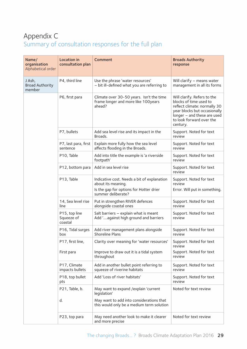
The changing Broads... ? Broads Climate Adaptation Plan 2016 29
Appendix C Summary of consultation responses for the full plan
Name/ organisationAlphabetical order
Location in consultation plan
Comment Broads Authority response
J Ash, Broad Authority member
P4, third line Use the phrase ‘water resources’ – bit ill-defined what you are referring to
Will clarify – means water management in all its forms
P6, first para Climate over 30-50 years. Isn’t the time frame longer and more like 100years ahead?
Will clarify. Refers to the blocks of time used to reflect climate: normally 30 year blocks but occasionally longer – and these are used to look forward over the century.
P7, bullets Add sea level rise and its impact in the Broads.
Support. Noted for text review
P7, last para, first sentence
Explain more fully how the sea level affects flooding in the Broads.
Support. Noted for text review
P10, Table Add into title the example is ‘a riverside footpath’
Support. Noted for text review
P12, bottom para Add in sea level rise Support. Noted for text review
P13, Table Indicative cost. Needs a bit of explanation about its meaning.Is the gap for options for Hotter drier summer deliberate?
Support. Noted for text reviewError. Will put in something.
14, Sea level rise line
Put in strengthen RIVER defences alongside coastal ones
Support. Noted for text review
P15, top lineSqueeze of coastal
Salt barriers – explain what is meant Add ‘….against high ground and barriers
Support. Noted for text review
P16, Tidal surges box
Add river management plans alongside Shoreline Plans
Support. Noted for text review
P17, first line,
First para
Clarity over meaning for ’water resources’
Improve to draw out it is a tidal system throughout
Support. Noted for text review Support. Noted for text review
P17, Climate impacts bullets
Add in another bullet point referring to squeeze of riverine habitats
Support. Noted for text review
P18, top bullet pts
Add ‘Loss of river habitats’ Support. Noted for text review
P21, Table, b.
d.
May want to expand /explain ‘current legislation’
May want to add into considerations that this would only be a medium term solution
Noted for text review
P23, top para May need another look to make it clearer and more precise
Noted for text review
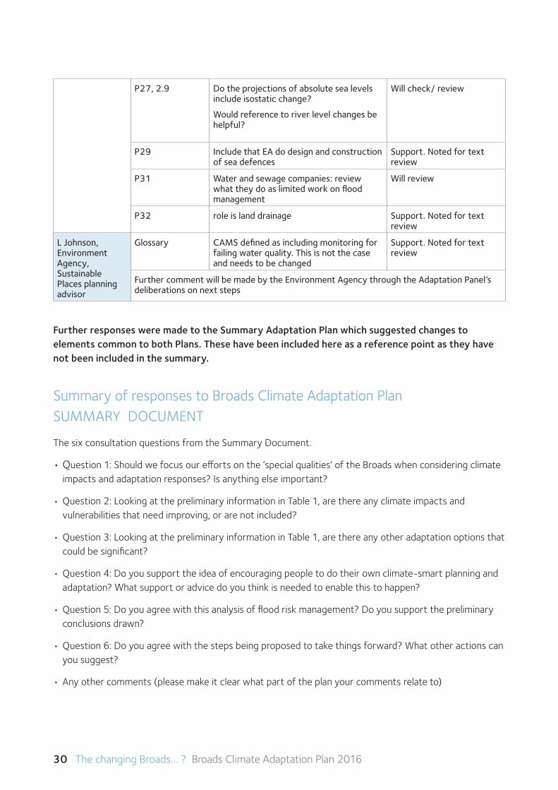
30 The changing Broads... ? Broads Climate Adaptation Plan 2016
P27, 2.9 Do the projections of absolute sea levels include isostatic change?
Would reference to river level changes be helpful?
Will check/ review
P29 Include that EA do design and construction of sea defences
Support. Noted for text review
P31 Water and sewage companies: review what they do as limited work on flood management
Will review
P32 role is land drainage Support. Noted for text review
L Johnson, Environment Agency, Sustainable Places planning advisor
Glossary CAMS defined as including monitoring for failing water quality. This is not the case and needs to be changed
Support. Noted for text review
Further comment will be made by the Environment Agency through the Adaptation Panel’s deliberations on next steps
Further responses were made to the Summary Adaptation Plan which suggested changes to elements common to both Plans. These have been included here as a reference point as they have not been included in the summary.
Summary of responses to Broads Climate Adaptation Plan SUMMARYDOCUMENT
The six consultation questions from the Summary Document.
•Question 1: Should we focus our efforts on the ‘special qualities’ of the Broads when considering climate impacts and adaptation responses? Is anything else important?
•Question2:LookingatthepreliminaryinformationinTable1,arethereanyclimateimpactsand vulnerabilities that need improving, or are not included?
•Question3:LookingatthepreliminaryinformationinTable1,arethereanyotheradaptationoptionsthatcould be significant?
•Question4:Doyousupporttheideaofencouragingpeopletodotheirownclimate-smartplanningandadaptation? What support or advice do you think is needed to enable this to happen?
•Question5:Doyouagreewiththisanalysisoffloodriskmanagement?Doyousupportthepreliminaryconclusions drawn?
•Question6:Doyouagreewiththestepsbeingproposedtotakethingsforward?Whatotheractionscanyou suggest?
•Anyothercomments(pleasemakeitclearwhatpartoftheplanyourcommentsrelateto)
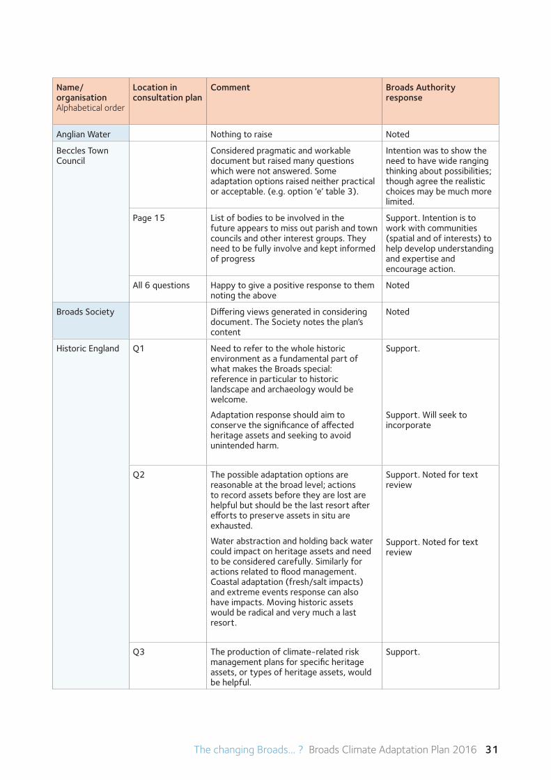
The changing Broads... ? Broads Climate Adaptation Plan 2016 31
Name/ organisationAlphabetical order
Location in consultation plan
Comment Broads Authority response
Anglian Water Nothing to raise Noted
Beccles Town Council
Considered pragmatic and workable document but raised many questions which were not answered. Some adaptation options raised neither practical or acceptable. (e.g. option ‘e’ table 3).
Intention was to show the need to have wide ranging thinking about possibilities; though agree the realistic choices may be much more limited.
Page 15 List of bodies to be involved in the future appears to miss out parish and town councils and other interest groups. They need to be fully involve and kept informed of progress
Support. Intention is to work with communities (spatial and of interests) to help develop understanding and expertise and encourage action.
All 6 questions Happy to give a positive response to them noting the above
Noted
Broads Society Differing views generated in considering document. The Society notes the plan’s content
Noted
Historic England Q1 Need to refer to the whole historic environment as a fundamental part of what makes the Broads special: reference in particular to historic landscape and archaeology would be welcome.
Adaptation response should aim to conserve the significance of affected heritage assets and seeking to avoid unintended harm.
Support.
Support. Will seek to incorporate
Q2 The possible adaptation options are reasonable at the broad level; actions to record assets before they are lost are helpful but should be the last resort after efforts to preserve assets in situ are exhausted.
Water abstraction and holding back water could impact on heritage assets and need to be considered carefully. Similarly for actions related to flood management. Coastal adaptation (fresh/salt impacts) and extreme events response can also have impacts. Moving historic assets would be radical and very much a last resort.
Support. Noted for text review
Support. Noted for text review
Q3 The production of climate-related risk management plans for specific heritage assets, or types of heritage assets, would be helpful.
Support.
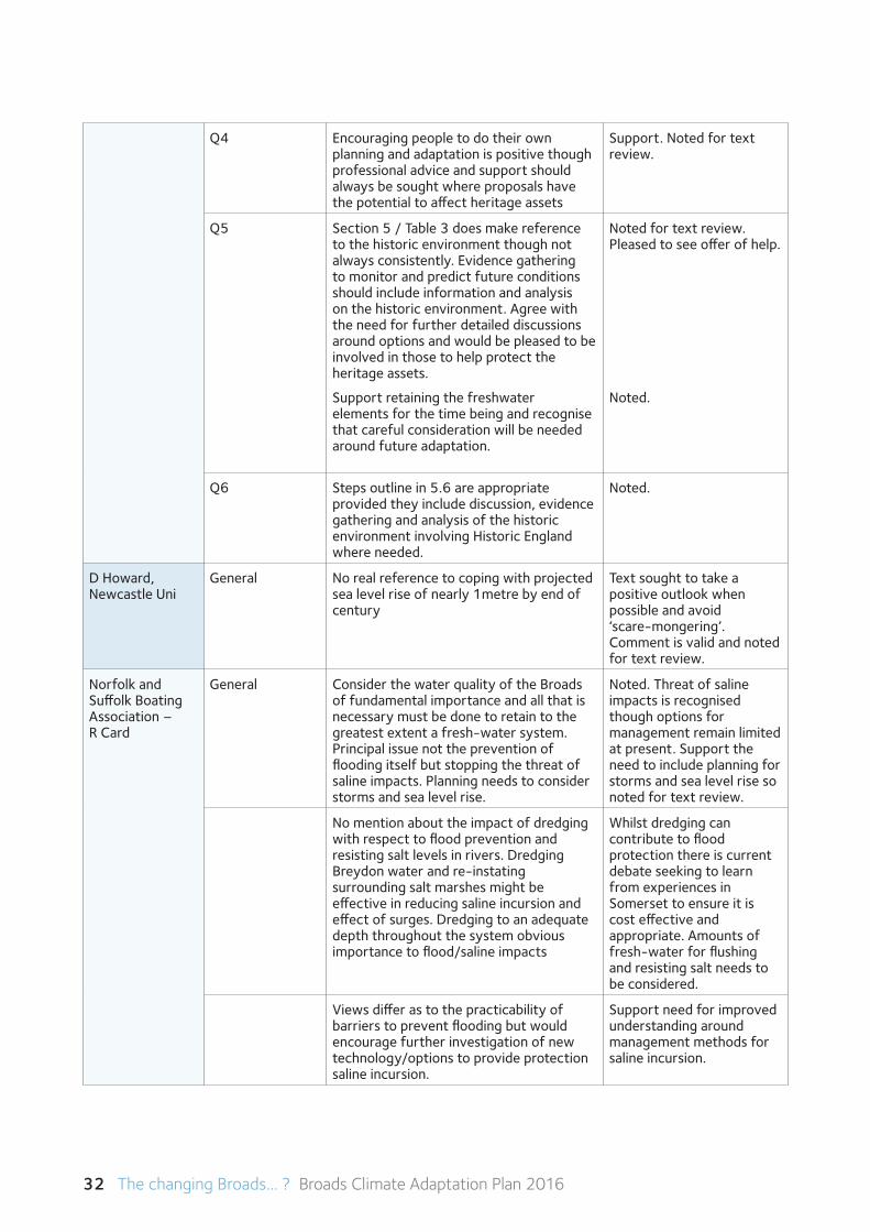
32 The changing Broads... ? Broads Climate Adaptation Plan 2016
Q4 Encouraging people to do their own planning and adaptation is positive though professional advice and support should always be sought where proposals have the potential to affect heritage assets
Support. Noted for text review.
Q5 Section 5 / Table 3 does make reference to the historic environment though not always consistently. Evidence gathering to monitor and predict future conditions should include information and analysis on the historic environment. Agree with the need for further detailed discussions around options and would be pleased to be involved in those to help protect the heritage assets.
Support retaining the freshwater elements for the time being and recognise that careful consideration will be needed around future adaptation.
Noted for text review. Pleased to see offer of help.
Noted.
Q6 Steps outline in 5.6 are appropriate provided they include discussion, evidence gathering and analysis of the historic environment involving Historic England where needed.
Noted.
D Howard,Newcastle Uni
General No real reference to coping with projected sea level rise of nearly 1metre by end of century
Text sought to take a positive outlook when possible and avoid ‘scare-mongering’. Comment is valid and noted for text review.
Norfolk and Suffolk Boating Association – R Card
General Consider the water quality of the Broads of fundamental importance and all that is necessary must be done to retain to the greatest extent a fresh-water system. Principal issue not the prevention of flooding itself but stopping the threat of saline impacts. Planning needs to consider storms and sea level rise.
Noted. Threat of saline impacts is recognised though options for management remain limited at present. Support the need to include planning for storms and sea level rise so noted for text review.
No mention about the impact of dredging with respect to flood prevention and resisting salt levels in rivers. Dredging Breydon water and re-instating surrounding salt marshes might be effective in reducing saline incursion and effect of surges. Dredging to an adequate depth throughout the system obvious importance to flood/saline impacts
Whilst dredging can contribute to flood protection there is current debate seeking to learn from experiences in Somerset to ensure it is cost effective and appropriate. Amounts of fresh-water for flushing and resisting salt needs to be considered.
Views differ as to the practicability of barriers to prevent flooding but would encourage further investigation of new technology/options to provide protection saline incursion.
Support need for improved understanding around management methods for saline incursion.
The changing Broads... ? Broads Climate Adaptation Plan 2016 33
Norfolk County Council
Need to assess if current special qualities are sustainable. Take joint approach between all levels/types of authorities and land owning bodies to plan to cope with shifts. Need to consider qualities as interrelating with the interconnections as important
Support need for considering interrelation-ships and promoting collaborative approach between different bodies.
Q4 Agree to people doing their own climate-smart planning which will need support to understand and interpret what is needed. Perhaps template to help? Provide material on line and on paper and with face to face options
Support the need for further assistance in developing skills around climate-smart planning and note template idea as an option.
Norwich & Norfolk Local Transport Group - D Carlow
General Worried that the BA are suggesting they are concerned about climate change but raised no sustainability objections to the Norwich Northern Distributor Road which will increase emissions. Worries would also relate to any support for Acle Straight dualling. Need to protect the environment.
Concerns noted. Balancing pros and cons on decision making can be testing and proving direct impacts can be challenging. Broads oCommunity approach hopes promoting climate-smart approach will help identify long term needs are not lost in short term goals.
RSPB General Detailed comments on the plan in appendix. These would have been easier to make with more detailed numbering (esp Table 1).
The RSPB have provided some helpful detailed comments on the content of the plan. These have not been comprehensively listed in this summary due to space but hopefully all substantive items are summarised. These will be followed up specifically with them and incorporated in iterations of the plan. The need for better numbering is acknowledged.
General Impacts and adaptation options are a good start but remain high level and too ill defined to provide certainty that appropriate long term measures will be implemented.
Plan must not be overly focused on flood risk and should consider holistic water management and other factors like invasive non-native species.
Need to recognise the opportunities climate change brings
Intention was to use the first full plan to raise awareness about the scale and scope of needs and encourage further action. Support the need to get on with a more detailed plan of action.
Support need for move to holistic water management. Emphasis on flooding because deemed as highest risk.
Support the need to include opportunities where relevant.
34 The changing Broads... ? Broads Climate Adaptation Plan 2016
General Appears to be noticeable difference between summary document and full document. E.g. why no table 2 in the full plan? Need to incorporate into the full the consultation process and outcomes
Full plan developed to a point where reactions of stakeholders were needed. Summary document developed to help stakeholders respond to significant elements. Will use the consultation to update and improve full plan and will include reference to consultation process and outcomes.
Consider Breydon Water to still function as an estuary (not a relict)
Noted for text review.
Section 3 / Q1 The special qualities represent the range of interests in the Broads However the plan lacks clear strategic intent for the next 25-30 year period incorporating the environment, biodiversity and maintenance of the integrity of the protected area network within a balanced approach to adaptation across all interests. Need to consider opportunities as well as impacts
Noted for text review the comment that the environmental elements are sometimes not equally referred to. Intention was to use the consultation process to help gauge stakeholders’ priorities in setting the medium to longer term strategic intent. Support idea of a clear future vision
Section 5 Greater clarity on the range of water pressures (quality, resources as well as flood) and the need for a holistic approach to adaptation options rather than the current emphasis just on flood risk
Support. Noted for text review.
Section 5 Further clarity/emphasis needed on the risks and opportunities related to species especially invasive non-native species
Noted for text review. Difficult to be sure non-native species invasion is due to climate change as opposed to accidental introductions.
Q2 Table 1 costs and impacts are overly optimistic in places such as related to coastal change and where habitat creation is identified.
Initial ideas set down to gauge other’s views. Noted for text review.
Q3 Oversimplification of the issues and measures; lack of a holistic plan for water management; lack of ambition in identifying opportunities; the need to be proactive and with less emphasis on letting market forces determine action (e.g. tourism related).
Summary plan written for all stakeholders with the intention of helping raise awareness and understand-ing perhaps from a low base. Difficult to identify intervention options when there remains ambivalence to act in places and insufficient powers / political will for change. Holistic water plan is supported although mechanisms for change are still unclear.
The changing Broads... ? Broads Climate Adaptation Plan 2016 35
General Appears to be noticeable difference between summary document and full document. E.g. why no table 2 in the full plan? Need to incorporate into the full the consultation process and outcomes
Full plan developed to a point where reactions of stakeholders were needed. Summary document developed to help stakeholders respond to significant elements. Will use the consultation to update and improve full plan and will include reference to consultation process and outcomes.
Consider Breydon Water to still function as an estuary (not a relict)
Noted for text review.
Section 3 / Q1 The special qualities represent the range of interests in the Broads However the plan lacks clear strategic intent for the next 25-30 year period incorporating the environment, biodiversity and maintenance of the integrity of the protected area network within a balanced approach to adaptation across all interests. Need to consider opportunities as well as impacts
Noted for text review the comment that the environmental elements are sometimes not equally referred to. Intention was to use the consultation process to help gauge stakeholders’ priorities in setting the medium to longer term strategic intent. Support idea of a clear future vision
Section 5 Greater clarity on the range of water pressures (quality, resources as well as flood) and the need for a holistic approach to adaptation options rather than the current emphasis just on flood risk
Support. Noted for text review.
Section 5 Further clarity/emphasis needed on the risks and opportunities related to species especially invasive non-native species
Noted for text review. Difficult to be sure non-native species invasion is due to climate change as opposed to accidental introductions.
Q2 Table 1 costs and impacts are overly optimistic in places such as related to coastal change and where habitat creation is identified.
Initial ideas set down to gauge other’s views. Noted for text review.
Q3 Oversimplification of the issues and measures; lack of a holistic plan for water management; lack of ambition in identifying opportunities; the need to be proactive and with less emphasis on letting market forces determine action (e.g. tourism related).
Summary plan written for all stakeholders with the intention of helping raise awareness and understand-ing perhaps from a low base. Difficult to identify intervention options when there remains ambivalence to act in places and insufficient powers / political will for change. Holistic water plan is supported although mechanisms for change are still unclear.
Q4 Support the climate-smart approach and the need to plan strategically but need to allow individual groups to identify the best approach for them. Ultimately unless interests work together the Broads climate adaptation plan is unlikely to be effective.
Support. Intention was to provide a structure for those wishing and needing to act including an over-all approach for a spatial area. Individual actions are welcomed and the need for a collaborative approach for effectiveness seen as important.
Conclusion A Climate Adaptation Plan for the Broads is essential to inform a consistent approach to management across the Broads in the future. The draft plan provides a good basis and aligns with the work that the RSPB is currently undertaking around its Futurescape areas and reserves. However, there remain a number of refinements that are required if a truly effective plan is to be created and implemented.
The RSPB looks forward to working positively with the Broads Authority to support the development of an appropriate climate adaptation plan.
Comments noted for text review. Support the idea of creating a clear and bold vision to stimulate action. Futurescape work is a good example of strategic thinking. Welcome the opportunity to work together positively to evolve and effective approach.
South Norfolk Council
Q1 List seems relevant and comprehensive and a reasonable list to use. Perhaps need reference to communities to include a human dimension
Support. Need to ensure human dimension is included.
Q2 In table 1 there are places where reference to impacts on communities needs to be added – e.g. under sea level rise and flash flooding
Support. Noted for text review.
Q4 Support the idea of local climate smart planning. May need to be support to help with the analysis and subsequent actions. Some can be tackled locally but may need to be a mechanism to coordinate action across wider areas
Support the need for assistance to develop planning effectively and that coordination of actions for larger scale change is likely to be needed.
Q5 Agree with analysis of flood risk Noted and welcomed.
Q6 Agree with next steps being proposed and having nothing to add
Noted and welcomed.
R Walpole General Can reviews of flood management include consideration of the provision/ improvement of footpaths?
Noted.
Woodbastwick Parish Council
General Not an ‘easy read’; recognise it is complex but would like at some point a document relating to ‘our community’
Intention was to try to make a complex subject accessible but when writing succinctly for a wide range of stakeholders examples may not always been ideal. Happy to explore how we can support community interests more.
36 The changing Broads... ? Broads Climate Adaptation Plan 2016
Q1 Special qualities argument should not override the needs of local people
Support the need to ensure local communities are considered part of the special qualities.
Table 1 Impacts and adaptation options seem heavily weighted to tourism / market forces: Should be qualified with regard to local communities need
Noted for text review. Intention is certainly to take a rounded view helping residents and visitors.
Table 2 Example not good for local communities. Support idea of own climate smart planning but will need technical support/advice and mechanism to involve local people in changes needed
Support the view that technical information and helping mechanisms will be needed and would welcome local community involvement in developing that.
Q5 Agree with flood risk analysis and support preliminary conclusions
Noted and welcomed.
5.6 3rd para Support principle of need for high quality information and needs to be appropriate to local level to help engage people
Noted.
Appendix D Further information
Publications and policy
Biodiversity 2020: A strategy for England’s wildlife and ecosystems services (Defra, 2011)
Broads National Character Area Profile (NE449), Natural England, 2013)
Climate change adaptation manual: evidence to support nature conservation in a changing climate (NE546) (Natural England and RSPB, EA Climate Ready Support Service, Forestry Commission, 2014)
Climate Change: An Overview and its Impact on the Living Lakes, a report prepared for the 8th Living LakesConference(Hulme,M.,D.ConwayandX.Lu.2003)
Climate-Smart Conservation: Putting Adaptation Principles into Practice (National Wildlife Federation, 2014)
IPCC Fifth Assessment Report (AR5) (Intergovernmental Panel on Climate Change, 2013-14)
National Adaptation Programme (UK Government website)
MoreinformationonUKGovernmentpolicyonclimatechangemaybefoundat:https://www.gov.uk/government/policies/adapting-to-climate-change
Responding to the impacts of climate change on the natural environment: The Broads (NE114) (Natural England, 2010)
The Potential Impacts of Climate Change on the Norfolk Broads (Price, Tyndall Centre, UEA, 2013)
The changing Broads... ? Broads Climate Adaptation Plan 2016 37
Tomorrow’s Norfolk, Today’s Challenge – A Climate Strategy for Norfolk (Norfolk County Council, 2008)
UK Government policy on climate change: https://www.gov.uk/government/policies/adapting-to-climate-change
Why Farming Matters to the Broads, NFU, 2010
Shoreline Management Plans (North Norfolk)
Broadland Rivers Catchment Plan (Broadland Catchment Partnership, 2014)
Broadland Rivers Catchment Flood Management Plan – Summary Report (Environment Agency, 2009)
Strategic Flood Risk Assessment
Development and Flood Risk Supplementary Planning Document – Broads Authority, 2008)
Broads Future animation - https://www.youtube.com/watch?v=8RL9meFrxqo
Publications and policy
Broads Authority – www.broads-authority.gov.uk
Broads OCommunity - http://www.broads-authority.gov.uk/looking-after/projects/broads-community
Climatic Research Unit (CRU), University of East Anglia - http://www.cru.uea.ac.uk/
Environment Agency - https://www.gov.uk/government/organisations/environment-agency
Living with Environment Change (LWEC) - http://www.lwec.org.uk/
Natural England - http://publications.naturalengland.org.uk/category/10003
The Centre for Social and Economic Research on the Global Environment (CSERGE), University of East Anglia - http://www.cserge.ac.uk/
Norfolk County Council http://www.norfolk.gov.uk/environment/flood_and_water_management/index.htm
38 The changing Broads... ? Broads Climate Adaptation Plan 2016
Appendix E Glossary of terms
CAMS and water abstraction
The Catchment Abstraction Management Strategy (CAMS) process assesses the availability of water resources for each river catchment, produces a strategy to manage water abstraction. The process is managed by the Environment Agency.
Carbon offsetting Carbon offsetting is used to compensate for an organisation’s or individual’s carbon emissions (e.g. from heating buildings, driving or flying) by funding an equivalent CO2 saving elsewhere.
Catchment Flood Management Plan
Catchment flood management plans (CFMPs) consider all types of inland flooding, from rivers, groundwater, surface water and tidal flooding. They also include the likely impacts of climate change.
Flood and Water Management Act 2010 (FWMA)
The Act provides for better, more comprehensive management of flood risk for people, homes and businesses, helps safeguard community groups from unaffordable rises in surface water drainage charges, and protects water supplies to the consumer. The Act places a duty on all Flood Risk Management Authorities (RMA) to co-operate with each other.
Greenhouse gas emissions
Gasses that, once in the atmosphere, influence the amount of energy reaching the earth’s surface from the sun and the amount being reflected back from the earth’s surface into space. A range of gases contribute to the greenhouse effect with the largest contributor being water vapour. However, over time, the gasses that are changing their proportions in the atmosphere the most and making the biggest alterations to the climate are carbon dioxide, nitrous oxide and methane.
Internal Drainage Board Statutory bodies dealing with the drainage of low lying land. Funded through levies from landowners (and making use of public grant aid), they are directed by local committees/boards.
Lead Local Flood Authority (LLFA)
Under the Flood and Water Management Act, LLFAs are required to prepare and maintain a strategy for local flood risk management including a register of assets affecting flooding, approving Sustainable Drainage Systems and changing ordinary water courses. The role is undertaken by Norfolk and Suffolk County Councils in the Broads.
River Basin Management Plan
A River Basin Management Plan (RBMP) outlines work that a range or organisations will undertake to comply with the Water Framework Directive. The Anglian RBMP covers the Broads catchment.
Shoreline Management Plan
Shoreline management plans (SMPs) are developed by Coastal Groups with members mainly from local councils and the Environment Agency. They identify the most sustainable approach to managing the flood and coastal erosion risks to the coastline in the short-term (0 to 20 years), medium term (20 to 50 years) and long term (50 to 100 years).
Strategic Flood Risk Assessment
A Strategic Flood Risk Assessment (SFRA) is a study carried out by one or more local planning authorities to assess the risk to an area from flooding from all sources, now and in the future.
Surface Water Management Plan (SWMP)
Surface water flooding covers flooding from runoff rain from impermeable surfaces (e.g. car parks) or where rain has percolated into the soil and then runs out at a lower level or flooding from small streams, ditches and drains. SWMPs are produced by Lead Local Flood Authorities using historical flood records and detailed models of water flow.
Water Framework Directive
European Union legislation that covers all inland and coastal waters. The Water Framework Directive (WFD) sets a framework that should provide substantial benefits for managing water over the long term.