climate risk management for smallholder agriculture in ... · climate risk management for...
TRANSCRIPT

United Nations Development Programme
CRISIS PREVENTION AND RECOVERY
CLIMATE RISK MANAGEMENT FORSMALLHOLDER AGRICULTURE
IN HONDURAS
Prepared by the International Institute for Sustainable Development (IISD)
January 2013

2
Copyright © UNDP 2013All rights reserved This report was commissioned by the United Nations Development Programme’s Bureau for Crisis Prevention and Recovery (BCPR), under the Climate Risk Management Technical Assistance Support Project (CRM TASP). The International Institute for Sustainable Development (IISD) implemented the CRM TASP in seven countries (Dominican Republic, Honduras, Kenya, Nicaragua, Niger, Peru and Uganda). This CRM TASP country report was authored by:
Marius Keller Cite as: United Nations Development Programme (UNDP), Bureau for Crisis Prevention and Recovery (BCPR). 2013. Climate Risk Management for Smallholder Agriculture in Honduras. New York, NY: UNDP BCPR.
Published by
United Nations Development Programme (UNDP), Bureau for Crisis Prevention and Recovery (BCPR), One UN Plaza, New York–10017
UNDP partners with people at all levels of society to help build nations that can withstand crisis, and drive and sustain the kind of growth that improves the quality of life for everyone. On the ground in 177 countries and territories, we offer global perspective and local insight to help empower lives and build resilient nations. www.undp.org

3
CONTENTS
FOREWORD ........................................................................................................................................................................................ 4
ACKNOWLEDGEMENTS .................................................................................................................................................................... 6
LIST OF ABBREVIATIONS AND ACRONYMS ................................................................................................................................... 7
EXECUTIVE SUMMARY ..................................................................................................................................................................... 8
INTRODUCTION .............................................................................................................................................................................. 10
APPROACH AND METHODS .................................................................................................................................................... 10
KEY CONCEPTS ......................................................................................................................................................................... 12
REPORT STRUCTURE ............................................................................................................................................................... 12
DEVELOPMENT PROFILE ................................................................................................................................................................ 13
NATIONAL DEVELOPMENT CONDITIONS, TRENDS AND CHALLENGES............................................................................. 13
NATIONAL DEVELOPMENT VISION, OBJECTIVES AND PRIORITIES ................................................................................... 16
THE AGRICULTURAL SECTOR .................................................................................................................................................. 17
CLIMATE PROFILE ........................................................................................................................................................................... 19
CURRENT CLIMATE VARIABILITY AND EXTREMES ............................................................................................................... 19
OBSERVABLE CHANGES IN CLIMATE ..................................................................................................................................... 21
PROJECTED CLIMATE TRENDS ............................................................................................................................................... 21
STATUS OF CLIMATE AND HAZARD INFORMATION ............................................................................................................. 24
CLIMATE IMPACTS AND RISKS ....................................................................................................................................................... 25
FUTURE CLIMATE IMPACTS ..................................................................................................................................................... 27
SMALLHOLDER VULNERABILITY TO CLIMATE HAZARDS ................................................................................................... 28
CLIMATE THREATS TO KEY DEVELOPMENT OUTCOMES ..................................................................................................... 31
INSTITUTIONS AND POLICIES FOR CLIMATE RISK MANAGEMENT ........................................................................................... 33
DISASTER RISK MANAGEMENT .............................................................................................................................................. 33
CLIMATE CHANGE .................................................................................................................................................................... 34
RECOGNITION OF CLIMATE RISK MANAGEMENT IN KEY POLICY DOCUMENTS .............................................................. 34
CLIMATE RISK MANAGEMENT ACTIVITIES .......................................................................................................................... 35
ASSESSMENT OF CLIMATE RISK MANAGEMENT CAPACITY ............................................................................................... 35
RECOMMENDATIONS FOR CLIMATE RISK MANAGEMENT ......................................................................................................... 37
ACTIONS .................................................................................................................................................................................... 37
GOVERNANCE ........................................................................................................................................................................... 43
FURTHER RESEARCH ............................................................................................................................................................... 44
REFERENCES .................................................................................................................................................................................... 45
4
FOREWORDClimate change has the potential to exacerbate conflict, cause humanitarian crises, displace people, destroy livelihoods and set-back development and the fight against poverty for millions of people across the globe.
For example it is estimated that over 20 million people in the Mekong Delta and 20 million in Bangladesh could be forced to move as their homes are affected by salt water incursion from rising sea levels. Entire populations of some low lying island states, such as Nauru or the Maldives may have to be relocated. In countries like Honduras, where more than half the population relies on agriculture, climate induced risks, such as Hurricane Mitch in 1998, which caused over US$ 2 billion in agricultural losses, will continue to pose a staggering potential for damage. Similarly, climate risk assessments in Nicaragua show that changes in rainfall patterns, floods and drought could put human health at risk by increasing the prevalence of respiratory and water borne diseases and malnutrition.
Long-term incremental changes will mean that people everywhere must learn to adapt to weather or rainfall patterns changing or shifts in ecosystems that humans depend upon for food. Perhaps more worrying however, is that climate variability and change will also bring unpredictable weather patterns that will in-turn result in more extreme weather events. Heat waves, droughts, floods, and violent storms could be much more common in the decades to come. Climate change is “loading the dice” and making extreme weather events more likely. These disasters will undermine the sustainability of development and render some practices, such as certain types of agriculture, unsustainable; some places uninhabitable; and some lives unliveable.
As climate change creates new risks, better analysis is needed to understand a new level of uncertainty. In order to plan for disasters, we need to understand how climate change will impact on economies, livelihoods and development. We need to understand how likely changes in temperature, precipitation, as well as the frequency and magnitude of future extreme weather will affect any sector, including agriculture, water-use, human and animal health and the biodiversity of wetlands.
This report is a product of the Climate Risk Management – Technical Assistance Support Project, which is supported by UNDP’s Bureau for Crisis Prevention and Recovery and Bureau for Development Policy. This is one in a series of reports that examines high-risk countries and focusses on a specific socio-economic sector in each country. The series illustrates how people in different communities and across a range of socio-economic sectors may have to make adaptations to the way they generate income and cultivate livelihoods in the face of a changing climate. These reports present an evidence base for understanding how climatic risks are likely to unfold. They will help governments, development agencies and even the communities themselves to identify underlying risks, including inappropriately designed policies and plans and crucial capacity gaps.
This series is part of a growing body of climate change adaptation resources being developed by UNDP. The Climate Risk Management – Technical Assistance Support Project has formulated a range of climate risk management assessments and strategies that bring together disaster risk reduction and climate change adaptation practices. The project is designing a common framework to assist countries in developing the necessary capacity to manage climate-induced risks to respond to this emerging threat. The climate risk assessments discussed in this report and others in the series will feed into a set of country-level projects and regional initiatives that will inform the practice of climate risk management for decades to come.

5
Addressing climate change is one of UNDP’s strategic priorities. There is a strong demand for more information. People at all levels, including small communities want to understand the potential impact of climate change and learn how they can develop strategies to reduce their own vulnerability. UNDP is addressing this demand and enabling communities and nations to devise informed risk management solutions. UNDP recognises that climate change is a crucial challenge to sustainable development and the goal of building resilient nations.
As the full effect of climate change becomes apparent, it is assessments such as these that will become the lynchpin of national responses and adaptation strategies for many years to come. Like the threat from many disasters, there is still time to prepare for the worst impacts of climate change in developing countries if we expand our understanding now.
This knowledge must be combined with real preparedness and action at all levels. Only then will we be able to stave off the worst impacts of climate change in the most vulnerable and high risk countries of our world.
Jordan Ryan Olav KjorvenAssistant Administrator and Director Assistant Administrator and DirectorBureau for Crisis Prevention and Recovery Bureau for Development PolicyUnited Nations Development Programme United Nations Development Programme

6
ACKNOWLEDGEMENTSThis report, ‘Climate Risk Management for Smallholder Agricutlure in Honduras,’ was commissioned under the Climate Risk Management – Technical Assistance Support Project (CRM TASP), a joint initiative by the Bureau for Crisis Prevention and Recovery (BCPR) and the Bureau for Development Policy (BDP), UNDP, and implemented by the International Institute for Sustainable Development (IISD).
The general methodology and analytical framework of the CRM TASP was conceptualized by Maxx Dilley, disaster partnerships advisor, and Alain Lambert, senior policy advisor, with key inputs from Kamal Kishore, programme advisor, Disaster Risk Reduction and Recovery Team, BCPR, in consultation with Bo Lim, senior climate change advisor, Environment and Energy Group, BDP. Within BCPR, the project implementation process has been supervised by Alain Lambert, Rajeev Issar and Ioana Creitaru, who provided regular inputs to ensure in-depth climate risk assessments and identification of tangible risk reduction and adaptation options. From BDP, Mihoko Kumamoto and Jennifer Baumwoll provided their input, comments and oversight to refine the assessment and recommendations. The overall project implementation has benefitted immensely from the strategic guidance provided by Jo Scheuer, coordinator, Disaster Risk Reduction and Recovery Team, BCPR, and Veerle Vandeweerd, director, Environment and Energy Group, BDP.
The climate risk assessments under the CRM TASP have been undertaken with the funding support of the Government of Sweden.
Building upon the CRM TASP general framework to tailor the process to country-level analysis, IISD developed a more detailed methodological framework for assessing climate risks and identifying climate risk management options in seven countries, including in Honduras. Within IISD, Anne Hammill supervised the overall project implementation. Marius Keller supervised all in-country activities in Honduras and is the lead author of the present report.
For their valuable contributions to the project implementation and climate risk assessment process, the project team would like to thank Dr. Nabil Kawas and his team at the National Autonomous University of Honduras; Francisco Argeñal of the National Meteorological Services of Honduras; consultant Andrea Rivera; and Livia Bizikova, Dean Medeiros and Matthew McCandless of IISD. The team would also like to thank Noelia Jover, Ginés Suárez and Juan Ferrando of UNDP Honduras for assisting with the coordination of the project and providing feedback on this report and other project outputs and, for useful comments and feedback on various drafts of this report, Jorge Quiñonez of the Secretariat for Planning and Cooperation, and all the participants of the final review workshop.

7
LIST OF ABBREVIATIONS AND ACRONYMSCCAD Central American Commission for Environment and Development
(Comisión Centroamericana de Ambiente y Desarrollo)
COPECO Permanent Commission of Contingencies, Honduras (Comisión Permanente de Contingencias)
CRM TASP Climate Risk Management Technical Assistance Support Project
ECLAC United Nations Economic Commission for Latin America and the Caribbean
ENSO El Niño Southern Oscillation
FAO United Nations Food and Agriculture Organization
GDP Gross Domestic Product
HDI Human Development Index
IISD International Institute for Sustainable Development
IPCC Intergovernmental Panel on Climate Change
ITCZ Intertropical Convergence Zone
MAGICC SCENGEN Model for the Assesment of Greenhouse-gas Induced Climate Change – A Regional Climate Scenario Generator
PESA Special Programme for Food Security
PRECIS Providing Regional Climates for Impacts Studies (climate modelling system)
SAG Ministry of Agriculture and Livestock, Honduras (Secretaría de Agricultura y Ganadería)
SERNA Secretariat of Natural Resources and Environment, Honduras
(Secretaría de Recursos Naturales y Ambiente)
SICA Integration of Central American States (Sistema de la Integración Centroamericana)
SINAGER National Risk Management System, Honduras (Sistema Nacional de Gestión de Riesgo)
UNAH National Autonomous University of Honduras (Universidad Nacional Autonoma de Honduras)
UNDP United Nations Development Programme
UNISDR United Nations Office for Disaster Risk Reduction

8
EXECUTIVE SUMMARYThis report presents the main results of a climate risk and risk management capacity assessment of smallholder agriculture in Honduras, conducted as part of the Climate Risk Management Technical Assistance Support Project (CRM TASP) of the United Nations Development Programme (UNDP). The combination of different scientific and participatory research streams, including literature reviews, community consultations, participatory scenario development, crop modelling, hazard and vulnerability mapping, and policy and capacity assessments, provides a basis for identifying climate risks for smallholder agriculture and prioritizing measures to manage them.
Honduras is a poor country with low levels of education and security and high environmental degradation. As such, it is inherently vulnerable to economic, social and natural stressors. Agriculture contributes 12 percent of the Gross Domestic Product (GDP), earns US$1.4 billion in foreign exchange per year, and provides livelihoods and food security for a majority of Hondurans. The current practice of expanding monocultures and cattle ranching is pushing smallholders onto ever poorer and steeper soils, making them especially vulnerable to climate extremes. Key current climate hazards include droughts and aridity in the west, centre, southeast and south; tropical storms and cyclones, which also lead to floods and landslides across the country but predominantly in the northeast; and cold fronts on the Caribbean coast. Climate projections indicate a hotter and drier future, particularly for the south and west and during the months of June through August, intensifying general water scarcity and recurrent midsummer droughts.
Every year, climate events claim dozens of lives, affect tens of thousands of people and/or cause millions of dollars in damage, especially in the agriculture sector. A 2001 drought related to El Niño led to agricultural losses of US$30 million. In 1998, Hurricane Mitch caused economy-wide damages of over US$3.7 billion, of which over US$2 billion occurred in agriculture. Climate hazards have had immediate impacts on rural communities: for example, subsistence crops such as maize and beans are highly sensitive to current and projected temperature and rainfall trends. Rural farming communities lack sufficient capacity to adapt to climatic changes, because of their low income and education levels coupled with environmental degradation. Despite the coping mechanisms in place, climate variability and change are increasingly overwhelming coping capacities and compromising the use of sustainable adaptation strategies.
The combination of increasing hazards and vulnerability not only puts smallholders at direct risk, but also can jeopardize the achievements of national and sectoral development goals, such as reduction of poverty and inequality; improvement of education, health and security; and access to water. The Honduran Government aims to reach an annual growth rate of 4 percent in the agriculture sector, raise exports by 70 percent over four years, increase production levels of staples, coffee, fruits and vegetables, and increase irrigation by 30 percent, but climate variability and change threaten these plans.
Honduras has a comprehensive national risk management system and an Inter-Institutional Committee on Climate Change, and the country has clearly designated coordinating authorities for both disaster management and climate change adaptation. Key policy documents, such as the ‘Country Vision 2010–2038 and National Plan 2010–2022’ (Honduras, República de Honduras, 2001), recognize climate risks as a development issue, yet no thorough mainstreaming has occurred for key policies such as the Public Sector Strategy on Agriculture and Food. Numerous activities are ongoing in both disaster risk reduction and climate change adaptation. The former picked up after the Hurricane Mitch disaster in 1998. The latter have mainly focused on research and capacity building so far. As a result, Honduras’ capacity to deal with climate risk is improving, but deficiencies remain in terms of vulnerability and risk assessments, prioritization procedures for risks and risk management options, coordination between disaster-risk and climate change–adaptation agencies, climate monitoring, data processing and accessibility, and implementation of climate risk management actions. Climate risks for smallholder agriculture and the resulting threats for larger development objectives should be reduced through a combination of practical actions, further research, and changes in policies and institutions. Based mainly on participatory exercises, the CRM TASP has identified priority climate risk management actions in the following areas:
y Improvement of local governance and social organization.
y Climate-conscious territorial planning.

9
y Water management, including reforestation.
y Soil management and agricultural practices, including crop diversification and agroforestry.
y Finance and insurance mechanisms for smallholders.
y Climate-proof infrastructure.
y Climate data collection, monitoring and tracking, and early-warning systems.
y Capacity development efforts to sustain the above risk management actions.
To facilitate the implementation of these actions, climate risk management policies and institutions need to be improved. We recommend the following strategies:
y Thorough mainstreaming of climate risk into key public policy documents such as the ‘Public Sector Strategy on Agriculture and Food.’
y Proper implementation of relevant public policies through improved governance.
y Strengthening of capacities, political clout and coordination among relevant government agencies.
Also, further research is needed on climate trends and extreme events, climate impacts and risks to crops, livelihoods and food security, and risk management options such as drought-resistant crops and irrigation technology. Such research should involve national research centres.

10
INTRODUCTIONClimate risk management is the systematic approach and practice of incorporating climate-related events, trends and projections into development decision-making to maximize benefits and minimize potential harm or losses. Climate change is altering the nature of climate risk, increasing uncertainty and forcing us to re-evaluate conventional climate risk management practices. Historical experience with climate hazards may no longer be a sound basis for evaluating risk: observable trends and longer-term, model-generated projections must also be taken into account if development is to be truly sustainable.
Recognizing this shifting reality, the UNDP, through its Bureau for Crisis Prevention and Recovery as well as the Environment and Energy Group of its Bureau for Development Policy, designed the CRM TASP to assist countries in identifying climate-related risks and risk management priorities and capacity needs as a basis for policy, planning and programme development. The International Institute for Sustainable Development (IISD) has been commissioned to implement the project in seven countries in Africa and the Latin America and Caribbean region, including Honduras, in close collaboration with governments, UNDP Country Offices and other partners.
In each country, the main outputs of the project are the prioritization of climate-related risks, a focused risk assessment for a priority sector or area, and the identification of risk management options for that sector or area. This information provides an evidence base for examining the adequacy of the institutional and policy environment for implementing risk management solutions. The present report summarizes the main results of the research conducted in Honduras, where the project stakeholders chose agriculture as the focus sector.
Figure 1. Participatory scenario development workshop in Tegucigalpa, Honduras. Photo: Marius Keller
APPROACH AND METHODS
Three key principles guide the implementation of the CRM TASP in each country. First, the project builds on existing climate risk information and aims to fill critical knowledge gaps. Second, the main research phase focuses on one key sector, in order to produce useful and concrete recommendations. Third, with a view to building capacity to identify, prioritize and manage climate risk, IISD is working closely with in-country partners that execute important parts of the research. These principles are put into practice in each country through a generic six-step implementation process (see table 1).

11
TABLE 1. SUMMARY OF PROJECT STEPS AND METHODS
PROJECT STEP PURPOSE METHODS USED IN HONDURAS1. Engagement y Raise awareness about CRM TASP.
y Secure country-level ownership and support for process.
y Inception trip, meetings and discussions with key stakeholders.
2. Broad climate risk assessment
y Understand and synthesize existing data and information on climate risk and risk management options.
y Literature reviews conducted by in-country consultants, published in Argeñal (2010a) and Kawas and Elvir Ferman (2011b).
3. Risk prioritization y Identify gaps and priorities for climate risk assessment and management, which can be addressed in a focused risk assessment.
y National inception workshop with key stakeholders; agriculture identified as focus sector in group discussions.
4. Focused climate risk assessment
y Understand the nature of climate risk for a specific priority sector, ecosystem or social group (agriculture was chosen as the focus sector in the case of Honduras).
y Modelling and statistical analysis of climate data (Argeñal 2011a, b).
y Hazard and vulnerability analysis and maps (Kawas, 2011; Kawas and Elvir Ferman, 2011a; Kawas, Elvir Ferman and Wiese, 2011; Kawas et al., 2011a, b, c).
y Crop modelling (Medeiros and McCandless, 2011). y Community consultations based on the Community-
Based Risk Screening Tool – Adaptation and Livelihoods (Rivera, 2011a).
5. Risk prioritization II y Identify and prioritize climate risk management options based on the more focused assessment.
y Participatory scenario development workshop (Rivera, 2011b).
y Policy and capacity analysis.
6. Reporting and dissemination
y Elaborate and validate results. y Secure country-level ownership of results
y National inception workshop with key stakeholders; agriculture identified as focus sector in group discussions.
In Honduras, different ministries, research institutes, non-governmental organizations and international organizations unanimously chose smallholder agriculture as the focus sector for the climate risk analysis, based on literature reviews and discussions at the national inception workshop held in May 2010. Both the importance of agriculture for exports and subsistence and the high vulnerability of the sector to climate hazards were cited as the main reasons for this choice. Agriculture contributes at least 12 percent of the Honduran GDP and earned almost US$1.4 billion in foreign exchange in 2008. It also provides a livelihood for the majority of the population. Past climate disasters have caused massive damage in the sector. For example, 1998 Hurricane Mitch led to losses of US$2 billion in agriculture. Project stakeholders considered the existing knowledge on climate risk for agriculture to be highly insufficient and identified a number of critical knowledge gaps.
A range of research tasks were undertaken subsequently to address some of these gaps. The National Autonomous University of Honduras worked on a number of hazard maps for the main climate extremes: hurricanes, floods, and droughts and aridity. The National Meteorological Service produced climate projections for the year 2025, based on widely used emissions scenarios, which complement existing projections for 2020, 2050 and 2090, as well as statistical analysis on the return periods of extreme rainfall events.
The National Autonomous University of Honduras also produced a vulnerability map for the entire country based on a large set of municipal-level data. Rivera (2011a) conducted local consultations based on the Community-Based Risk Screening Tool – Adaptation and Livelihoods in communities across the country. They provided a bottom-up perspective on climate shocks and stress, impacts, and existing coping strategies. To complement the risk analysis, IISD applied the Decision Support System for Agrotechnology Transfer model to evaluate the effects of future climate change on maize and beans in eight representative sites.
The preliminary results of the climate risk assessment were presented to a broad group of stakeholders from the agricultural sector in a participatory scenario development (Bizikova, Boardley and Mead, 2010, p. 64; Bizikova, Dickinson and Pinter, 2009) workshop in March 2011. In group exercises and plenary discussions, workshop participants then identified and prioritized climate risk management options for different regions of the country. Policy and capacity analysis completed the climate risk assessment.

12
KEY CONCEPTS
In this report, ‘climate risk’ refers to the probability of harmful consequences or expected losses resulting from the interaction of climate hazards with vulnerable conditions (UNISDR, 2004). ‘Climate hazard’ refers to a potentially damaging hydrometeorological event or phenomenon that can be characterized by its location, intensity, frequency, duration and probability of occurrence. This report considers both events with an identifiable onset and termination, such as a storm, flood or drought, and more permanent changes, such as a trend or transition from one climatic state to another, as hazards (Lim et al., 2005).
Figure 2. Components of climate risk
‘Exposure’ is a second element of climate risk. It refers to the presence of people and assets in areas where hazards may occur (Cardona et al., 2012). Finally, ‘vulnerability’ refers to the potential for a system to be harmed by something, and in the CRM TASP this ‘something’ is a climate hazard. When assessing vulnerability, we need to recognize the hazard specificity of people’s vulnerability; indeed, the factors that make people vulnerable to earthquake are not necessarily the same as those that make people vulnerable to floods (UNDP 2004). We understand vulnerability to be a function of a system’s sensitivity and its adaptive capacity, as depicted in Figure 2.
REPORT STRUCTURE
This report has six sections. After this introduction, ‘Development Profile’ (pp. 13–18) describes the current development conditions, trends and objectives, including those associated with the agriculture sector in particular, which sets the baseline for assessing climate risks. The ‘Climate Profile’ section (pp. 19–24), on climate conditions, variability and change, describes mainly the hazard side of the risk equation. Next, the ‘Climate Impacts and Risks’ section (pp. 25–32) provides an overview for the country as well as a detailed analysis for smallholder agriculture, building on the various primary research tasks described above. The section ‘Institutions and Policies for Climate Risk Management’ (pp. 33–36) looks at the institutions, policies and initiatives that exist to deal with climate impacts and risks. The final section, ‘Recommendations for Climate Risk Management,’ (pp. 37–44) concludes with actions to reduce the risk of negative impacts on smallholder agriculture, changes needed to institutions and policies to facilitate the implementation of such actions, and directions for further research.
13
DEVELOPMENT PROFILEThe general development conditions of a country play an important role in determining climate risk, particularly the vulnerability of its sectors. Agriculture, for instance, is much more sensitive to climatic conditions than many other sectors; therefore an economy that is heavily dependent on agriculture is more sensitive to climate variability and change than one based on services. Factors like incomes or social capital are key elements of adaptive capacity and determine in part how well people can deal with climate hazards. This first section lays the basis for the subsequent risk assessment by summarizing development conditions, trends and challenges, as well as the vision, objectives and priorities for future development. Agricultural conditions, trends and priorities are given particular attention.
NATIONAL DEVELOPMENT CONDITIONS, TRENDS AND CHALLENGES
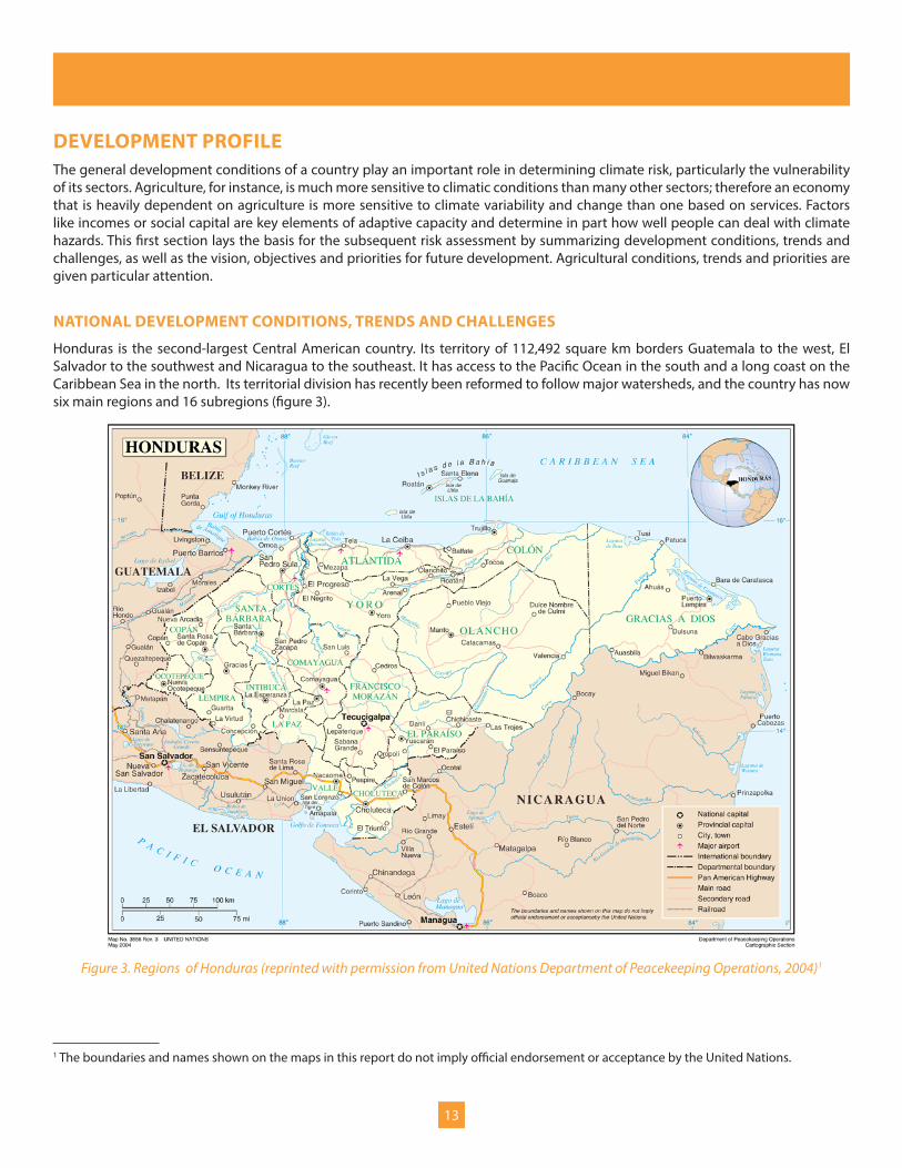
Honduras is the second-largest Central American country. Its territory of 112,492 square km borders Guatemala to the west, El Salvador to the southwest and Nicaragua to the southeast. It has access to the Pacific Ocean in the south and a long coast on the Caribbean Sea in the north. Its territorial division has recently been reformed to follow major watersheds, and the country has now six main regions and 16 subregions (figure 3).
Figure 3. Regions of Honduras (reprinted with permission from United Nations Department of Peacekeeping Operations, 2004)1
1 The boundaries and names shown on the maps in this report do not imply official endorsement or acceptance by the United Nations.

14
In 2010 an estimated 7.6 million people lived in Honduras, about a third of whom lived in or around the two main cities, Tegucigalpa and San Pedro Sula. About half of the population still lives in rural areas, although the percentage is shrinking. Current population growth is about 2 percent per year. In spite of a decreasing growth rate, the Government expects that by 2050 some 10.6 to 14.3 million people will live in Honduras, with most of the increase taking place in urban areas (United Nations Department of Social and Economic Affairs, Population Division, 2011).
Poverty and human development
Honduras is the second-poorest country in Central America, after Nicaragua. Average income in terms of purchasing power parity was US$3,750 in 2008, which is one-fourth that of Panama. Thanks to one of the highest inequality ratios in Latin America, poverty is widespread in Honduras. According to estimates from 2009, 58.8 percent of all households were poor, down from 63.7 percent in 2001. Extremely poor people made up 36.4 percent of households, down from 44.2 percent in 2001. The reduction of relative poverty rates conceals substantial increases in absolute numbers over the past years. Currently, about one million households live below the poverty line (UNDP, 2010). Furthermore, rural poverty has been significantly higher than urban poverty. According to the International Fund for Agriculture Development (2010), about 74 percent of the country’s poor people, and 86 percent of the extremely poor, live in rural areas.
Education is in a dire state. Primary public schools only teach 160 days or 950 hours a year on average (Honduras, República de Honduras, 2010). Although 89.5 percent of all children between 6 and 11 years of age go to school, compared with 83.8 in 1990, the average child only goes to school for 6.5 years, compared with over nine in Panama and Belize. A mere 58.8 percent of all children complete nine years of schooling, though 94 percent of all persons between 15 and 24 years of age are literate. According to the United Nations’ Millennium Development Goals, all three rates should reach 100 percent in 2015, but all three goals are likely to be missed (UNDP, 2010).
Some success has been achieved in health. Child mortality has dropped, from 48 out of 1,000 live births in the period from 1991 to 1996, to 30 ten years later. For infant mortality, the rate has dropped from 35 to 23. Nevertheless, the respective Millennium Development Goal is unlikely to be reached. Maternal mortality dropped rapidly between 1990 and 1997 but has since remained far above the 2015 goal of 46 per 100,000 live births. Life expectancy is lower than the regional average. On the other hand, medical assistance has improved in many ways. Trends in HIV/AIDS rates appear to have been reversed, and malaria and tuberculosis prevalence has been dropping rapidly. Malnutrition has been decreasing, too. Furthermore, Honduras is close to achieving certain goals related to water and sanitation: 86.1 percent of all households now have access to improved water sources, compared with 76.9 percent in 1990. The share of dwellings with access to basic sanitation went from 51.9 percent to 78.2 percent in the same period (UNDP, 2010).
Gender equity has also improved. The share of girls in schools has increased and is now significantly higher than the share of boys at all levels except primary schooling. However, several indicators are starting to stagnate or are even reversing. For instance, in the last election the number of female members of parliament decreased from 25 percent to 20 percent (UNDP, 2010).
Together with Guatemala and El Salvador, Honduras has one of the highest crime rates in the world. In 2010, 6,239 homicides were committed, according to the Institute for Democracy, Peace and Security (Instituto Universitario en Democracia, Paz y Seguridad, 2011). This amounts to 78 homicides per 100,000 people, up from 67 in 2009 and 30.7 in 2000, and represents one of the highest rates in the world. Many crimes are related to drug trafficking, although robberies, politics and other motives are also important. Youth gangs, known as maras, are responsible for a large part of this criminal activity (World Bank, 2011b).
The UNDP’s Human Development Index (HDI) summarizes the developmental state of countries by ranking them according to life expectancy, schooling and income. Honduras currently ranks 106th, slightly higher than Nicaragua and Guatemala but much lower than Panama and Costa Rica.

15
TABLE 2. HUMAN DEVELOPMENT INDEX VALUES AND COMPONENTS FOR CENTRAL AMERICA (DATA SOURCE: UNDP, 2011)
COUNTRYHDI
RANK (2011)
HDI VALUE (2011)
LIFE EXPECTANCY (YEARS, 2011)
MEDIAN YEARS OF SCHOOLING
(2011)
EXPECTED YEARS OF SCHOOLING
(2011)
GROSS NATIONAL INCOME PER CAPITA
(CONSTANT 2005 PPP USD)
Belize 93 0.699 76.1 8.0 12.4 5,812
Costa Rica 69 0.744 79.3 8.3 11.7 10,497
El Salvador 105 0.674 72.2 7.5 12.1 5,925
Guatemala 131 0.574 71.2 4.1 10.6 4,167
Honduras 121 0.625 73.1 6.5 11.4 3,443
Nicaragua 129 0.589 74.0 5.8 10.8 2,430
Panama 58 0.768 76.1 9.4 13.2 12,335
Average 100.86 0.67 74.57 7.09 11.74 6,372.71
Important differences in development also exist at the sub-national level. The highest levels of development can be found in large cities in the centre and north, as well as in tourism areas such as the Bay Islands. Nevertheless, more than half of the municipalities exhibit a low or medium-to-low development status according to the HDI. They can mainly be found in the western areas, but also in the centre and east (UNDP, 2006a).
Economy and politics
Valued at market exchange rates, the Honduran GDP amounted to US$15.3 billion, or US$2,016 per capita, in 2010. The economy is based on international trade of agricultural commodities and manufactured goods (World Bank, 2011b). In 2009, sectors contributed to GDP as follows: 12 percent was earned in agriculture, hunting, forestry and fishing; 18 percent in manufacturing; 6 percent in construction; 16 percent in wholesale, retail trade, restaurants and hotels; and 7 percent in transport, storage and communication (United Nations Statistics Division, 2011).
The Honduran economy is very open in terms of trade flows, with aggregated imports and exports amounting to 129 percent of GDP in 2008. Annual economic growth was over 6 percent in the years before the global economic crisis, became negative in 2009 and is now resuming a pace of about 4 percent growth per year (IMF, 2011). This growth has largely been explained by strong export performance, especially of assembly factories, and remittances sent by family members who emigrated, mostly to the United States (World Bank, 2011b).
Honduras has been a relatively stable democracy since military rule ended in 1981. In 2009 a political crisis erupted, with President Zelaya on one side and the legislative branch and the judiciary on the other. The army removed Zelaya from office by force. As a result, Honduras was internationally isolated, and relations only started to improve slowly after the next presidential elections were held in late 2009 (Honduras, Comisión de la Verdad y la Reconciliación, 2011).
Environment
Despite efforts such as increasing the size of protected areas, the Honduran environment shows clear signs of rapid degradation. The land area covered by forests decreased from 66 percent in 1990 to 41.5 percent in 2006, the highest deforestation rate of any Central American country. Water resources are threatened by overexploitation, as well as by contamination from diverse sources that include waste, agricultural drainage, surface runoff and mining leachates. In coastal areas, mangroves are being cut down for shrimp farming. Tourism, industrial activity, agricultural pollution, overfishing and other factors are contributing to general coastal degradation (United Nations Environment Programme, 2010).

16
NATIONAL DEVELOPMENT VISION, OBJECTIVES AND PRIORITIES
In 2010 the incoming Honduran Government presented its development perspectives in a document encompassing both a country vision for the period up to 2038 and a national plan for the three legislative terms from 2010 to 2022 (Honduras, República de Honduras, 2010). The vision provides a long-term framework addressing the following four strategic objectives:
1. Eradication of extreme poverty and improvement of education, health and social protection.
2. Improvement of democracy and security.
3. Improvement in productivity, opportunities, employment and sustainable resource use, and reduction in environmental vulnerability reduction.
4. A transition to a modern, transparent, responsible, efficient and competitive state.
The national plan, on the other hand, guides the work of the current and the next two Governments. It is made up of eleven strategic themes, each of which have a set of quantitative indicators that allow progress to be measured by the end of each legislative period until 2022, as well as in 2038, the end year of the country vision. Table 3 presents the strategic themes, sample indicators for each theme and its target value for 2022.
TABLE 3. STRATEGIC THEMES OF THE NATIONAL PLAN AND SAMPLE PROGRESS INDICATORS (HONDURAS, REPÚBLICA DE HONDURAS, 2010)
NATIONAL PLAN STRATEGIC THEME SAMPLE PROGRESS INDICATORS, WITH TARGET VALUE FOR 20221. Sustainable development of the population Demographic dependency rate decreases from 78.4% to 66.4%.
2. Democracy, citizenship and governance UNDP gender empowerment index rises from 0.58 to 0.7; extra-legal land occupation drops from 70% to 40%.
3. Poverty reduction, asset generation and equal opportunities
Number of (extremely) poor households falls from 59.2% (36.2%) to 41% (21%).*
4. Social emancipation through education and culture Rate of basic education increases from 92.5% to 100%.
5. Health as a basis for improving living conditions Child mortality falls by half; incidence of malaria drops by 60%; rural water access rises from 63.2% to 85%.
6. Security as a condition for development Homicide rate decreases by about 50%.
7. Regional development, natural resources and environment
75% instead of 0% of the regions have and execute land-use plans; share of managed water catchment areas increases from 10% to 70%.
8. Productive infrastructure as an engine for economic activity
Agricultural land under irrigation increases from 90,000 hectares to 250,000 hectares.
9. Macroeconomic stability as a basis for internal savings GDP growth rate increases to 7% per year; Gini coefficient for inequality shrinks from 0.55 to 0.48.
10. Competitiveness, country image and development of productive sectors The number of tourists almost doubles.
11. Adaptation to and mitigation of climate change Indicators are still under development.
* Differences from current poverty figures presented previously may be due to different base years or sources of information.
The very comprehensive country vision and national plan do not explicitly prioritize economic sectors. However, certain sectors are implicitly considered to be strategically important. Agriculture and the food industry are mentioned in the context of ensuring food security and increasing export levels. Expanding irrigation is a priority in the context of agriculture. A second key sector is forestry, because of its importance for forestry products, tourism and ecosystem services, including carbon credits. Infrastructure is a further focus area and includes telecommunications, transport and energy. The expansion of hydro-energy is particularly emphasized. In the service sector, tourism and offshore services such as contact centres are highlighted.

17
The goals of the national plan are aligned with the Millennium Development Goals, according to which by 2015 Honduras should reduce extreme poverty and hunger by half compared with 1990 levels, achieve full employment and provide decent work for all, offer primary education to all children, eliminate gender inequality in education, reduce child mortality by two-thirds, reduce maternal mortality by three-quarters, ensure universal access to reproductive health care, arrest and begin to reduce the spread of HIV/AIDS, ensure universal access to HIV/AIDS treatment, arrest and begin to reduce the incidence of malaria and other major diseases, incorporate sustainable development into national plans and programmes and reverse the loss of environmental resources, reduce biodiversity loss, reduce the percentage of people without sustainable access to water and sanitation by half, improve the lives of slum dwellers and achieve several goals related to the creation of a global development alliance (United Nations Statistics Division, 2011).
A further relevant document is Honduras’ ‘Poverty Reduction Strategy Paper,’ developed by the Government in collaboration with the World Bank and the International Monetary Fund. Honduras’ current plan is valid for the period from 2001 through 2015 (Honduras, República de Honduras, 2001). Its goals are largely in line with Millennium Development Goals, the country vision and the national plan.
THE AGRICULTURAL SECTOR
Agriculture is one the main sectors of the Honduran economy. According to official statistics, the share of GDP accounted for by agriculture, hunting, forestry and fishing was 12 percent in 2009 (United Nations Statistics Division, 2011); however, this share increases to 21 percent if industrial food production is included (Ordaz et al., 2010). Adding all goods and services related to agriculture and food, the Ministry for Agriculture and Livestock (Honduras SAG, 2010) estimates the total share to be as high as 40 percent to 45 percent of GDP. The sector has grown more or less in line with the entire economy, although its growth has experienced more inter-annual variation than other sectors (Honduras SAG, 2010). Total agricultural exports were worth US$1,389 million in 2008. Coffee (US$575 million), palm oil (US$210 million) and bananas (US$170 million) were the main foreign exchange earners (FAO, 2011). Table 4 shows the harvested area, production and estimated production value for selected key crops.
TABLE 4. HARVESTED AREA, PRODUCTION AND VALUE FOR SELECTED KEY CROPS IN HONDURAS, 2009 (DATA SOURCE: FAO, 2011)
CROP HARVESTED AREA (HA) PRODUCTION (T) VALUE (1,000 USD)*
Bananas 23,643 690,625 180,874
Beans, dry 104,059 70,633 65,809
Coffee, green 230,000 205,800 489,351
Maize 335,514 587,235 180,281
Oil palm fruit 100,000 1,526,000 205,857
Oranges 17,032 270,096 28,790
Palm oil not applicable 290,000 229,042
Sorghum 36,027 37,117 11,447
Sugar cane 77,484 6,203,140 108,555
Bananas 23,643 690,625 180,874
*This value has been estimated by multiplying production quantities by 2008 prices per ton.
Agriculture is even more important for employment and food security. The sector provides work to more than half the employed population (UNDP, 2006b). Many of them—over 30 percent of the total population and 54 percent of the rural population—live in smallholder families who produce staple foods such as maize, beans, rice and sorghum (Baumeister, 2010), which are also the four most important crops for the Honduran diet, in decreasing order (Honduras SERNA, 2011a).

18
Agriculture and livestock breeding occupy about one-third of Honduran territory (World Bank, 2011a). Smallholders generally have to grow their subsistence crops on the steepest and poorest lands. In contrast, most of the country’s commercial plantations, consisting of large-scale banana, sugar cane and palm oil monocultures, are located in the fertile valleys, such as the Valle de Sula (International Fund for Agriculture Development, 2010). In absolute terms, the highest number of smallholders can be found in the northern departments of Cortés, Santa Bárbara and Yoro, where commercial production of sugar cane, bananas and coffee coexists with staple food production. Smallholders make up the highest percentage of the total population in the western departments of Lempira, Ocotepeque, Copán, Intibucá, La Paz and Comayagua (Baumeister, 2010). Among the communities consulted as part of the CRM TASP, those located in the central, western and southern highlands relied heavily on growing maize, beans, coffee and other crops. On the Caribbean coast, families often have small plots of land with rice, maize, root vegetables and fruits, but rely also on income from fisheries. In the south, communities often depend on income from day labour growing maize, sugarcane, melon or pineapple, or in shrimp culture, as a complement to smallholder agriculture (Rivera, 2011a).
Over the last decades, the absolute number of smallholders has stagnated, and their share of the total population has decreased. The total area cultivated by smallholders has expanded only slightly over the past 20 years, and the average area per household stood at a low 1.29 hectares in 2006 (Baumeister, 2010). However, expansion of monocultures and livestock breeding has been putting enormous pressure on land use and has pushed smallholders to ever-less-productive lands (Honduras SERNA, 2011a). The productivity of the agricultural sector is generally low: Per employed person, only US$3,240 was earned in 2005, one-third the income in Costa Rica (UNDP, 2006b). As national production stagnates, more and more staple foods come from abroad. According to the National Institute of Statistics, 42 percent of maize consumption and 19 percent of bean consumption was imported, thereby increasing the exposure to global price shocks (Honduras, Instituto Nacional de Estadistica, 2009).
In the large majority of households, tasks are clearly separated between genders: while men cultivate the land, women are more involved in harvesting, post-harvest activities, processing and commercialization of products in local markets (Baumeister, 2010).
The country vision and national plan consider agriculture and the food industry as key sectors for development, with a view to both ensuring food security and increasing export revenues. Expanding irrigation is one of the measured progress indicators (Honduras, República de Honduras, 2010). More detailed priorities are laid out in the ‘Public Sector Strategy on Agriculture and Food of the Ministry for Agriculture and Livestock’ (Honduras SAG, 2010), which is explicitly linked to the goals of the national plan and country vision. Its overall objective is to reduce rural poverty. It aims to reduce the percentage of rural households living in poverty from 72 percent in 2009 to 62 percent in 2014. It also aims for a reduction of extreme rural poverty from 58 percent to 48 percent in the same period.2 Related to this, the GDP of the agriculture and food sector should increase by 4 percent a year. The strategy also lays out a range of specific objectives on competitiveness, production and productivity. For instance, by 2014 the ministry aims to increase agriculture and food exports by 70 percent; increase the value of fruit and vegetable exports by 30 percent; increase the value of coffee exports by 5 percent a year; replace US$18 million worth of onion, potato, carrot and garlic imports with local crops; construct or rehabilitate 5,000 km of new rural roads; increase production of staple foods by 15 percent; increase the strategic reserve of maize and beans by 10 percent; and increase the irrigated area by 30 percent.
2 Note that these figures refer explicitly to rural poverty, as opposed to the poverty-reduction goals in the national plan and country vision.
Key messages: Development profile
y Honduras faces enormous development challenges: average income, education, security and the state of the environment are poor even compared with the low benchmark set by regional averages.
y Agriculture is a key sector for economic production, exports, employment and food security, but it suffers from low productivity and growth. Smallholders are being pushed to ever-poorer and steeper soils as monocultures and cattle ranching expand.
y The government has a national plan and country vision with a wide range of quantified development goals, some of which relate to agriculture or climate risk.
y The government’s Public Sector Strategy on Agriculture and Food aims to reduce rural poverty by growing the agricultural sector by 4 per cent a year, raise its exports by 70 per cent over four years, increase the production of staple foods, coffee, fruits and vegetables, and increase irrigation by 30 per cent.

19
CLIMATE PROFILEThe Honduran climate is generally tropical, yet the interaction of the country’s orography with the Intertropical Convergence Zone (ITCZ), air pressure and movements, weather fronts and tropical cyclones lead to important variations in climatic conditions across the country. The country has three main climatic zones: the Caribbean coast in the north, the mountainous areas in the centre and the Pacific coast in the south. In the two latter zones, two seasons can be clearly distinguished. The dry season runs from November to April, and the wet season lasts from May to October, although a reduction in precipitation known as canícula can be observed in the middle of the latter season. On the Caribbean coast, rain falls all year round, with a marked reduction between February and May (Argeñal, 2010b).
Annual average rainfall ranges from 800 to 3200 mm. The driest areas are located in the mountainous areas in the centre, whereas the Caribbean coast, especially in the north and in the far eastern area of La Moskitia, receives the highest quantities of precipitation. Mean temperatures in December, the coldest month, range from 8°C in high mountain areas to 28°C in the southern plains. In April, the hottest month, they range from 10°C to 31°C, respectively (Argeñal, 2010b).
CURRENT CLIMATE VARIABILITY AND EXTREMES
Within living memory, important deviations from the average climate have been observed in Honduras, including in the form of climate hazards such as droughts, tropical storms, cyclones, cold fronts, heavy rainfall, floods, landslides and storm surges.
Climate variability in Honduras has mainly been driven by the activity of the ITCZ, cold fronts and the El Niño Southern Oscillation (ENSO). The ITCZ is a worldwide band where northern and southern trade winds come together and force air up in to the atmosphere. Most tropical storms and cyclones are formed there (United States National Air and Space Administration, 2011). Cold fronts originating in polar regions make landfall on Honduras’ northern coast between October and March. ENSO is a climate pattern characterized by changes in ocean surface temperatures and pressure in the tropical eastern Pacific. Warm deviations are called El Niño, whereas cold deviations are called La Niña. ENSO periods occur every four to seven years and last 12 to 18 months. They affect air circulation, precipitation and temperatures across the tropical Pacific and can cause climate hazards such as droughts, heavy rainfall, floods and landslides. In Honduras, El Niño leads to a significant increased rainfall during July, August and September (Argeñal, 2010b).
Figure 4. Average rainfall, millimetres per year (originally published in Argeñal, 2010b)
Figure 5. April mean temperatures (originally published in Argeñal, 2010b)

20
Droughts are temporary and recurrent climatic events caused by a lack of rainfall and with negative consequences on ecological or human systems (Smakhtin and Schipper, 2008, p. 12). In Honduras’ mountainous areas and on the Pacific coast, dry periods occur every year between November and April, and often in July and August—a period referred to as canícula, or midsummer drought. Apart from these regular seasonal patterns, droughts occur often during El Niño phases, which tend to reduce rainfall and increase average temperatures and, thereby, evapotranspiration. During a moderate El Niño event, precipitation can decrease by over 80 percent in July and August in southern and western areas, which leads to an extension of the midsummer drought by about two weeks. By October, large parts of the west, centre and south experience rainfall deficits of over 40 percent (Argeñal, 2010b). A map elaborated by Argeñal (2010b) and reproduced in figure 6 confirms that the southern and western areas of Honduras are most at risk of severe drought.
Tropical storms and cyclones that make landfall in Honduras originate in the Atlantic Ocean north and east of Honduras. The official cyclone season lasts from June to November, although some cyclones have occurred as early as May in the past. The peak of cyclonic activity falls in the months of September and October. Kawas et al. (2011a) analysed the pathways of the 29 tropical cyclones that had some direct or indirect impact on Honduran territory between 1970 and 2010 (see figure 7). In addition to the trajectory of the eye of the hurricane, the entire influence zone was taken into account in order to create a map showing the return periods of cyclones for different parts of Honduras (see figure 8).
Figures 7 and 8. Pathways and hazard maps of tropical cyclones (originally published in Argeñal, 2010b)
The red area, almost entirely situated in the department of Gracias a Dios, faces one cyclone every other year. The yellow area is affected by about one cyclone every three years, whereas in the green area, the return period is approximately 10 years. Note that this map does not consider the intensity or impacts of the cyclone.
Little information is available on heavy rainfall in Honduras. Argeñal (2011a) looked at rainfall intensity in Tegucigalpa, the capital, taking into account data series from 1973 to 2010.3 His analysis reveals that heavy precipitation events, in which at least 11.7 mm of rain falls within five minutes, occur every five years. Events in which 25.3 mm of rain falls during a 15-minute period, or in which 92.9 mm of precipitation falls in a 24-hour period, each occur once every five years on average. The most extreme rainfall tends to have return periods of less than 100 years. Historically, the highest quantity measured over 24 hours was 185.5 mm, in Tegucigalpa, during Hurricane Mitch in October 1998.
3 Due to data limitations, other areas were not considered.
Figure 6. Rainfall anomalies during moderate El Niño events (originally published in Argeñal, 2010b)
21
Floods in Honduras are usually provoked by tropical storms and hurricanes. All regions of Honduras have experienced floods in the past, yet the north appears to have been affected more often than other areas, which is in line with this area’s higher rainfall quantities, occurrence of cold fronts and higher frequency of tropical cyclones. Floods most often occur between August and November, when the ITCZ is most active and produces depressions, storms and hurricanes (Kawas et al., 2010). By affecting rainfall patterns, La Niña events can also provoke floods. For example, rainfall quantities in the centre and south can almost double in November during moderate La Niña years (Argeñal, 2010b).
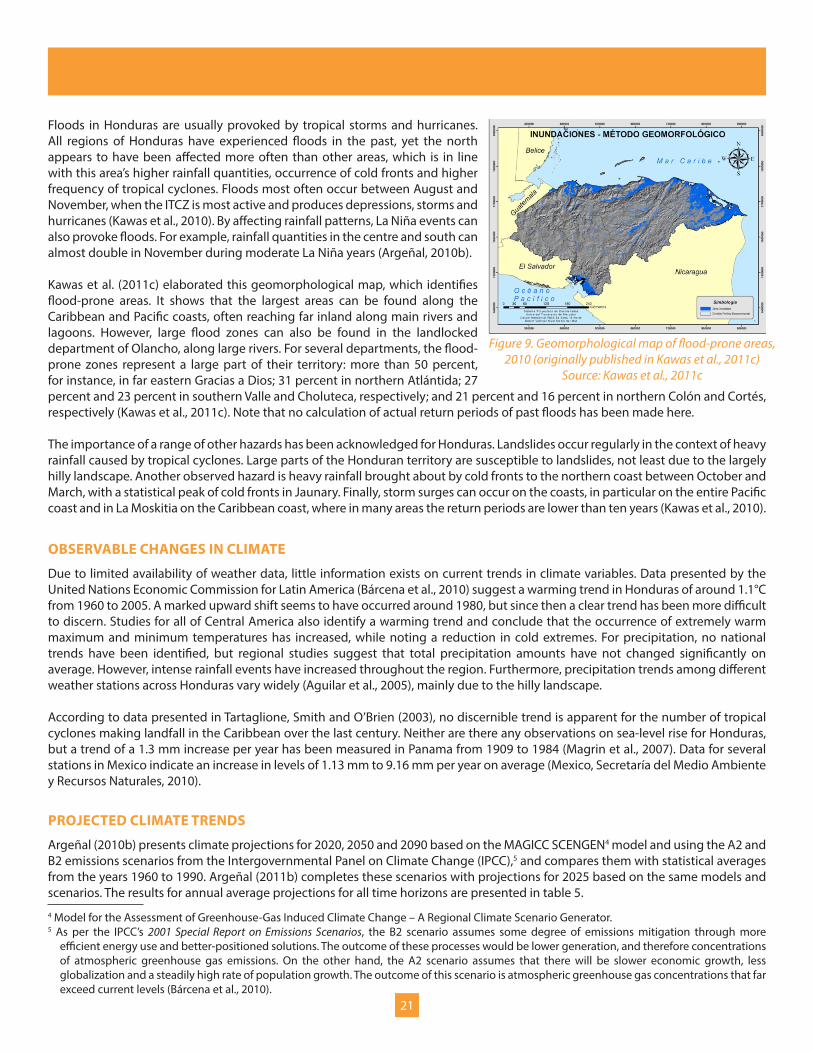
Kawas et al. (2011c) elaborated this geomorphological map, which identifies flood-prone areas. It shows that the largest areas can be found along the Caribbean and Pacific coasts, often reaching far inland along main rivers and lagoons. However, large flood zones can also be found in the landlocked department of Olancho, along large rivers. For several departments, the flood-prone zones represent a large part of their territory: more than 50 percent, for instance, in far eastern Gracias a Dios; 31 percent in northern Atlántida; 27 percent and 23 percent in southern Valle and Choluteca, respectively; and 21 percent and 16 percent in northern Colón and Cortés, respectively (Kawas et al., 2011c). Note that no calculation of actual return periods of past floods has been made here.
The importance of a range of other hazards has been acknowledged for Honduras. Landslides occur regularly in the context of heavy rainfall caused by tropical cyclones. Large parts of the Honduran territory are susceptible to landslides, not least due to the largely hilly landscape. Another observed hazard is heavy rainfall brought about by cold fronts to the northern coast between October and March, with a statistical peak of cold fronts in Jaunary. Finally, storm surges can occur on the coasts, in particular on the entire Pacific coast and in La Moskitia on the Caribbean coast, where in many areas the return periods are lower than ten years (Kawas et al., 2010).
OBSERVABLE CHANGES IN CLIMATE
Due to limited availability of weather data, little information exists on current trends in climate variables. Data presented by the United Nations Economic Commission for Latin America (Bárcena et al., 2010) suggest a warming trend in Honduras of around 1.1°C from 1960 to 2005. A marked upward shift seems to have occurred around 1980, but since then a clear trend has been more difficult to discern. Studies for all of Central America also identify a warming trend and conclude that the occurrence of extremely warm maximum and minimum temperatures has increased, while noting a reduction in cold extremes. For precipitation, no national trends have been identified, but regional studies suggest that total precipitation amounts have not changed significantly on average. However, intense rainfall events have increased throughout the region. Furthermore, precipitation trends among different weather stations across Honduras vary widely (Aguilar et al., 2005), mainly due to the hilly landscape.
According to data presented in Tartaglione, Smith and O’Brien (2003), no discernible trend is apparent for the number of tropical cyclones making landfall in the Caribbean over the last century. Neither are there any observations on sea-level rise for Honduras, but a trend of a 1.3 mm increase per year has been measured in Panama from 1909 to 1984 (Magrin et al., 2007). Data for several stations in Mexico indicate an increase in levels of 1.13 mm to 9.16 mm per year on average (Mexico, Secretaría del Medio Ambiente y Recursos Naturales, 2010).
PROJECTED CLIMATE TRENDS
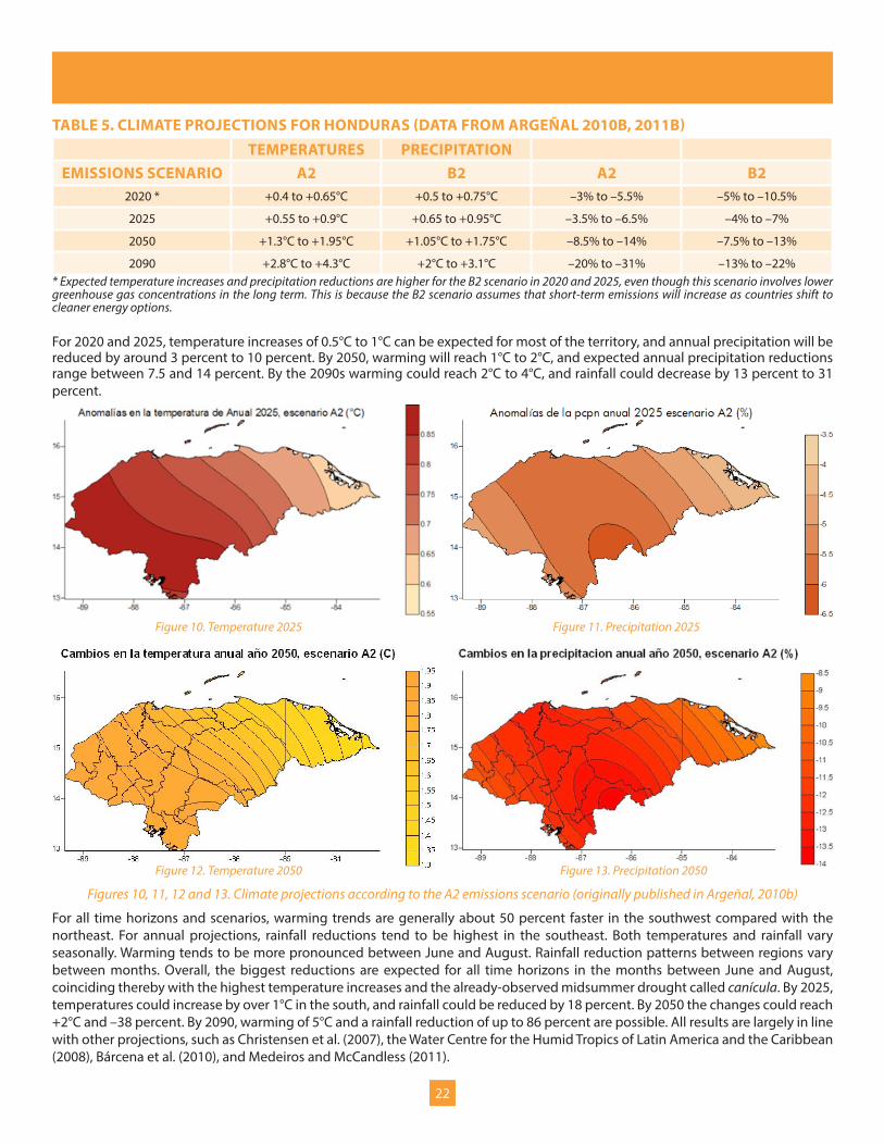
Argeñal (2010b) presents climate projections for 2020, 2050 and 2090 based on the MAGICC SCENGEN4 model and using the A2 and B2 emissions scenarios from the Intergovernmental Panel on Climate Change (IPCC),5 and compares them with statistical averages from the years 1960 to 1990. Argeñal (2011b) completes these scenarios with projections for 2025 based on the same models and scenarios. The results for annual average projections for all time horizons are presented in table 5.
4 Model for the Assessment of Greenhouse-Gas Induced Climate Change – A Regional Climate Scenario Generator.5 As per the IPCC’s 2001 Special Report on Emissions Scenarios, the B2 scenario assumes some degree of emissions mitigation through more
efficient energy use and better-positioned solutions. The outcome of these processes would be lower generation, and therefore concentrations of atmospheric greenhouse gas emissions. On the other hand, the A2 scenario assumes that there will be slower economic growth, less globalization and a steadily high rate of population growth. The outcome of this scenario is atmospheric greenhouse gas concentrations that far exceed current levels (Bárcena et al., 2010).
Figure 9. Geomorphological map of flood-prone areas, 2010 (originally published in Kawas et al., 2011c)
Source: Kawas et al., 2011c
22
TABLE 5. CLIMATE PROJECTIONS FOR HONDURAS (DATA FROM ARGEÑAL 2010B, 2011B)TEMPERATURES PRECIPITATION
EMISSIONS SCENARIO A2 B2 A2 B22020 * +0.4 to +0.65°C +0.5 to +0.75°C –3% to –5.5% –5% to –10.5%
2025 +0.55 to +0.9°C +0.65 to +0.95°C –3.5% to –6.5% –4% to –7%
2050 +1.3°C to +1.95°C +1.05°C to +1.75°C –8.5% to –14% –7.5% to –13%
2090 +2.8°C to +4.3°C +2°C to +3.1°C –20% to –31% –13% to –22%* Expected temperature increases and precipitation reductions are higher for the B2 scenario in 2020 and 2025, even though this scenario involves lower greenhouse gas concentrations in the long term. This is because the B2 scenario assumes that short-term emissions will increase as countries shift to cleaner energy options.
For 2020 and 2025, temperature increases of 0.5°C to 1°C can be expected for most of the territory, and annual precipitation will be reduced by around 3 percent to 10 percent. By 2050, warming will reach 1°C to 2°C, and expected annual precipitation reductions range between 7.5 and 14 percent. By the 2090s warming could reach 2°C to 4°C, and rainfall could decrease by 13 percent to 31 percent.
Figures 10, 11, 12 and 13. Climate projections according to the A2 emissions scenario (originally published in Argeñal, 2010b)
For all time horizons and scenarios, warming trends are generally about 50 percent faster in the southwest compared with the northeast. For annual projections, rainfall reductions tend to be highest in the southeast. Both temperatures and rainfall vary seasonally. Warming tends to be more pronounced between June and August. Rainfall reduction patterns between regions vary between months. Overall, the biggest reductions are expected for all time horizons in the months between June and August, coinciding thereby with the highest temperature increases and the already-observed midsummer drought called canícula. By 2025, temperatures could increase by over 1°C in the south, and rainfall could be reduced by 18 percent. By 2050 the changes could reach +2°C and –38 percent. By 2090, warming of 5°C and a rainfall reduction of up to 86 percent are possible. All results are largely in line with other projections, such as Christensen et al. (2007), the Water Centre for the Humid Tropics of Latin America and the Caribbean (2008), Bárcena et al. (2010), and Medeiros and McCandless (2011).
Figure 10. Temperature 2025 Figure 11. Precipitation 2025
Figure 12. Temperature 2050 Figure 13. Precipitation 2050

23
Sea-level rise is expected to continue, although no national-level projections are available. McSweeney, New and Lizcano (2008) apply a regional adjustment to the global projections by Meehl et al. (2007) and predict an increase of 0.18 m to 0.43 m by the 2090s using the B1 (low emission) scenario, and 0.23 m to 0.56 m for the A2 (high emission) scenario, relative to sea levels from 1980 to 1999.
Extreme events are more difficult to project. According to Magrin et al. (2007), many regional studies indicate extreme events will occur more frequently in the future. Simulations from Christensen et al. (2007), based on the A1B scenario, indicate that more very hot days and dry extremes will occur in Central America. The Water Centre for the Humid Tropics of Latin America and the Caribbean (2008) undertook projections for cyclonic activity under the A2 (high emissions) scenario, using the PRECIS6 model, and found that while events may become more intense, their frequency will not vary significantly. The methodological foundations for such projections are still weak (Smith et al., 2010). A link between anthropogenic climate change and ENSO has not been established. Changes have been observed in the intensity of El Niño events and the location of the surface temperature abnormality since 1970, but have not been conclusively linked to global warming (Trenberth and Hoar, 1997; Lee and McPhaden, 2010; McPhaden, Lee and Clurg, 2011).
Kawas et al. (2011b) elaborated aridity maps for the year 2010, 2025 and 2050 based on the A2 and B2 scenarios (see figures 14 to 16). The maps show the relative abundance of water based on precipitation, solar irradiation, evaporation and evapotranspiration projections. The maps show that the country could be almost entirely under water stress by 2050. The B2 scenario maps are similar. The projections for the northeastern region are based on very few weather stations.
Figures 14, 15 and 16. Aridity Index for the years 2010, 2025 and 2050, based on the A2 emissions scenario (originally published in Kawas et al., 2011b)
6 PRECIS (Providing Regional Climates for Impacts Studies) is a regional climate modelling system developed by the Hadley Centre in the United Kingdom’s Met Office. For more information see http://precis.metoffice.com.

24
STATUS OF CLIMATE AND HAZARD INFORMATIONA relatively complete picture of current and future climate hazards and trends can be obtained from the available data and information. The main driving factors and general characteristics of today’s climate variability are well understood, and the main zones of influence are known for key hazards such as droughts, cyclones and floods. Recent and robust climate projections are available for temperatures and rainfall.
Nevertheless, important capacity and knowledge gaps remain. Past weather data is patchy. For example, the temperature data used in Argeñal (2010b, 2011b) relies on only eight weather stations, as many stations have not recorded data continuously for a sufficiently long period of time. Continuous data is only available for a few decades, making it difficult to discern climate trends with certainty. No national data is available on sea-level rise (Kawas, 2011). Furthermore, existing information is often dispersed among numerous institutions and databases, hard to compare, and difficult to access. Little precise information is available on the frequency, intensity and exact location of extreme events such as droughts (Kawas and Elvir Ferman, 2011b). Early-warning systems are equally patchy, underdeveloped and badly maintained.7 The country has few climatologists and other relevant experts.
Other issues relate to the lack of models and methods. For example, return periods for extreme events have only been calculated in a few cases. Climate projections rely on global circulation models with a resolution of a 250-km square (Argeñal, 2010b) and cannot project changes in hydrological cycles at regional scales (Magrin et al., 2007). Regional climate models have not been used extensively in the region, as they are still being tested and developed (Magrin et al., 2007). As a result, local projections are uncertain, particularly for rainfall, where spatial variation is greater. The hilly landscape of Honduras exacerbates this problem, since changes in atmospheric circulation can induce large variability at the local scale. Furthermore, a large part of the rainfall in Honduras occurs in the context of tropical storms during the hurricane season, which are not well-captured by current climate models (Christensen et al., 2007). Even more difficult are projections of extreme events themselves, as noted earlier.
The CRM TASP project has been able to fill certain gaps, for instance by commissioning the first calculations of return periods for extreme rainfall events (Argeñal, 2011a), analysis of pathways and influence zones of tropical cyclones (Kawas et al., 2011a), and aridity and flood maps (Kawas et al., 2011b,c). Other projects, including the Adaptation Fund–financed project on climate resilience in the urban water sector, also aim to improve knowledge and capacity in this area. Nevertheless, large gaps remain, some of which have to be addressed at the international level (climate models, for instance), while others, such as more and better-equipped weather stations and climate experts, have to be dealt with in the country.
7 Personal communication with Dennis Funes, UNDP Honduras, January 24, 2012.
Key messages: Climate profile
y Climate variability is mainly influenced by the ITCZ, cold fronts coming in from polar regions, and ENSO.
y Key hazards include droughts in the west, centre, southeast and south; tropical storms and cyclones, which also lead to floods and landslides; and cold fronts on the Caribbean coast.
y Climate models project a hotter and drier future. Trends are more extreme for the south and west, and are particularly pronounced in the months from June to August, intensifying recurrent midsummer droughts.
y Important capacity and knowledge gaps exist regarding climate information, including a lack of weather stations and continuous data series, dispersed and scarce knowledge, a lack of experts, and insufficient early-warning systems.
25
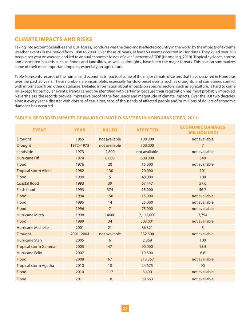
CLIMATE IMPACTS AND RISKSTaking into account casualties and GDP losses, Honduras was the third-most-affected country in the world by the impacts of extreme weather events in the period from 1990 to 2009. Over these 20 years, at least 53 events occurred in Honduras. They killed over 300 people per year on average and led to annual economic losses of over 3 percent of GDP (Harmeling, 2010). Tropical cyclones, storms and associated hazards such as floods and landslides, as well as droughts, have been the major threats. This section summarizes some of their most important impacts, especially on agriculture.
Table 6 presents records of the human and economic impacts of some of the major climate disasters that have occurred in Honduras over the past 50 years. These numbers are incomplete, especially for slow-onset events such as droughts, and sometimes conflict with information from other databases. Detailed information about impacts on specific sectors, such as agriculture, is hard to come by, except for particular events. Trends cannot be identified with certainty, because their registration has most probably improved. Nevertheless, the records provide impressive proof of the frequency and magnitude of climate impacts. Over the last two decades, almost every year a disaster with dozens of casualties, tens of thousands of affected people and/or millions of dollars of economic damages has occurred.
TABLE 6. RECORDED IMPACTS OF MAJOR CLIMATE DISASTERS IN HONDURAS (CRED, 2011)
EVENT YEAR KILLED AFFECTED ECONOMIC DAMAGES (MILLION USD)
Drought 1965 not available 100,000 not available
Drought 1972–1973 not available 300,000 7
Landslide 1973 2,800 not available not available
Hurricane Fifi 1974 8,000 600,000 540
Flood 1976 20 15,000 not available
Tropical storm Alleta 1982 130 20,000 101
Flood 1990 5 48,000 100
Coastal flood 1993 39 67,447 57.6
Flash flood 1993 374 15,000 56.7
Flood 1994 150 15,000 not available
Flood 1995 14 25,000 not available
Flood 1996 7 75,000 not available
Hurricane Mitch 1998 14600 2,112,000 3,794
Flood 1999 34 503,001 not available
Hurricane Michelle 2001 21 86,321 5
Drought 2001–2004 not available 332,500 not available
Hurricane Stan 2005 6 2,869 100
Tropical storm Gamma 2005 47 90,000 15.5
Hurricane Felix 2007 1 19,500 6.6
Flood 2008 67 313,357 not available
Tropical storm Agatha 2010 18 24,675 90
Flood 2010 117 3,400 not available
Flood 2011 18 59,663 not available

26
As table 6 illustrates, hurricanes, storms, floods and landslides, phenomena which are often associated with one another, are recurrent climate extremes that affect both the population and the economy. Hurricane Mitch, in 1998, was the most violent event in recorded history, killing over 14,000 people, affecting a third of the population and causing economic damages of US$3.8 billion—almost three-quarters of total GDP in 1998 (World Bank, 2011b). Much of the damage was concentrated in the big cities, where human and economic exposure is highest (Kawas et al., 2010). Figure 17 shows the trajectory of Hurricane Mitch and the number of casualties per municipality. Interestingly, much loss of life occurred relatively far away from the centre of the hurricane, which highlights both the size of the hurricane and the variation in exposure and vulnerability across the country.
Extreme events affect agriculture in multiple ways. Cyclones, floods and landslides can destroy crops directly. Hurricanes Mitch (1998) and Stan (2005), for instance, devastated coffee crops just before harvest time (Tucker, Eakin and Castellanos, 2010). According to ECLAC (1999), Hurricane Mitch caused the production of maize to fall by 58 percent, sugar cane by 60 percent and bananas by 85 percent. Almost 30 percent of the land used for export agriculture was affected. Total economic damages to the sector were estimated at some US$2 billion.
Apart from direct destruction, excessive moisture related to extreme rainfall and floods can cause plants to rot. Coastal floods can lead to saltwater intrusion, which can cause crop failure and forces cattle to drink farther upstream in rivers. In the longer run, sedimentation, the contamination of water sources and the general degradation of watersheds affect the arable land cover and increase the spread of plant diseases. Finally, infrastructure damage can prove devastating for agriculture, too. Hurricane Mitch caused almost $500 million in damage to the transport and communications infrastructure (ECLAC, 1999). Roads are regularly interrupted as a result of extreme events, and this impedes market access for farmers. Crucial irrigation and water retention can also be affected (Rivera, 2011a,b).
As slow-onset disasters with many indirect effects, droughts are less visible in disaster statistics than rapidly unfolding events like hurricanes. Nevertheless, their effects are equally damaging, especially for agriculture. This is because plants have specific requirements for temperatures and rainfall throughout the crop cycle. Arabica coffee, for instance, the predominant variety in Central America, grows best between 18°C and 22°C (Tucker et al. 2010). Bean growth is also highest at similarly moderate temperatures. The optimum temperature is higher for maize, but growth nevertheless decreases markedly with temperatures above 30°C. In Honduras, maize requires about 100 mm of water per month during the growth period, and beans about 50 mm per month. Droughts during growth can therefore lead to high or even total crop losses. In addition, higher evapotranspiration under higher temperatures leads to more rapid decomposition of soils and therefore reduces the ability of soils to retain water. This reduced resilience can increase the negative impact of droughts on crops (Honduras SERNA, 2011a).
A drought associated with the 1997/98 extreme El Niño event caused the production of staples such as maize and beans to drop by 50 percent to 70 percent, with even higher losses in the heavily affected south (Relief Web, 2011). Similar impacts were observed in another El Niño episode in 2009/10 (Honduras News, 2010). In 2011 another drought led to economic damages of over US$30 million in agriculture (Ordaz et al., 2010). Impacts reported in community consultations confirm the sensitivity of agriculture to droughts. Farmers in the community of Talpetate, in the department of Valle, for instance, mentioned crop losses of more than 80 percent during the worst droughts (Rivera, 2011a).
Plant diseases and plagues are a further, though less understood consequence of droughts . Higher temperatures tend to increase reproduction of insects and parasites. In addition, plants may be weakened through water and temperature stress, and therefore more susceptible to disease (Honduras SERNA, 2011a). Plant diseases are also one of the major concerns reported by communities during consultations (Rivera, 2011a).
Figure 17. Trajectory of Hurricane Mitch and associated casualties by municipality (originally published in
Kawas and Elvir Ferman, 2011a)

27
Other relevant climate-related hazards in Honduras include wind and cold spells. Farmers in the highlands considered these threats to be significant, as wind can destroy crops directly or through soil erosion and gradual desertification. Cold spells can severely damage or kill plants (Rivera, 2011a; Honduras SERNA, 2011a).
FUTURE CLIMATE IMPACTS
Future climate impacts for a number of important sectors have recently been identified and prioritized in the context of the National Climate Change Strategy (Honduras SERNA, 2011a) and the Second National Communication to the United Nations Framework Convention on Climate Change (Honduras SERNA, 2011b). Water, agriculture and food security, forests and biodiversity, marine and coastal systems, human health, and risk management are considered to be vulnerable sectors. The main future climate impacts related to water concern its increasing scarcity. Severe water stress will affect human consumption and thereby health and productivity; limit agricultural production and thus threaten food security; reduce the potential for hydro-energy; and damage ecosystems. Climate change may also increase extreme events such as tropical storms and floods and thereby lead to excess water, with all its associated risks.
Forests and biodiversity may increasingly be affected by fires, plagues and diseases, lack of water, changing ecosystems, invasive species, and the destruction of ecological corridors, thanks to increasing temperatures and reduced average rainfall. Impacts on marine and coastal systems relate to shifts and loss in coastlines and beaches, saline intrusion of superficial and subterranean waters, and changing conditions for marine ecosystems, especially coral reefs. In health, rising temperatures could extend the geographic distribution of vector diseases, such as dengue, malaria and chagas fever, and increase their rates of reproduction. Water-borne and airborne disease could increase, too, because of higher temperatures and the increasing occurrence of stranding waters, for instance. Water stress can also lead to chronic diseases and a lack of domestic hygiene, with related health effects.
Climate change impacts on maize and beans
In a study conducted as part of the CRM TASP, Medeiros and McCandless (2011) estimated the sensitivity of maize and beans, and small-scale cultivation of these staple crops, to projected increases in temperatures and reductions in rainfall, based on simulations with the Decision Support System for Agrotechnology Transfer model. Ecophysiological models like this one can predict climate change impacts more precisely than other methods because they take into account soil texture, water availability, temperature and soil nitrogen dynamics, as well as agricultural practices such as crop varieties, planting dates, row spacing, irrigation, fertilization rates and timing. Maize and beans were selected for the study because of their preeminent importance for the diet of Hondurans. The authors analysed climate impacts in seven municipalities in Honduras with a particularly high total area of maize and bean cultures. These were located at altitudes ranging from 411 m to 1665 m above sea level, in the departments Cortes in the north, Copan in the west, Lempira in the southwest, El Paraiso in the southeast and Choluteca in the south, allowing the study to cover different climatic regions of the country. The study focused on specific cultivars for each crop, on the first planting season of the year and on monocultures rather than intercropping systems. As specific cultivars grown in Honduras are not modelled in the Decision Support System for Agrotechnology Transfer model, other cultivars were selected for modelling in consultation with local agronomists.
Based on localized climate scenarios, which are largely in line with projections presented above, results presented by Medeiros and McCandless (2011) indicate significant reductions in crop yields. Maize yields averaged over the seven sites are expected to decrease by 4 percent in 2025, and by 12 percent in 2050, compared with 2000. Average bean yields decrease by 11 percent in 2025 and 32 percent in 2050. Modelling results revealed that crop yields were generally less affected by climate change in cooler, higher altitudes and that in lowland areas the thermal optima are exceeded, especially for beans. These results suggest that climate change will have a more important impact on lowland agriculture.

28
Figures 18 and 19. Average crop yield changes for eight representative sites under climate change projections (originally published in Medeiros and McCandless, 2011)
The findings of Medeiros and McCandless (2011) broadly confirm the results of a Ricardian analysis by Ordaz et al. (2010), who found that higher temperatures in Honduras will reduce yields of maize, beans and coffee over the century. However, Ordaz et al. (2010) see larger impacts occurring mainly in the second half of the century, suggesting that the impacts of climate change could grow exponentially once the current temperature ranges are clearly exceeded and rainfall shortages intensify.
Future climate variability and change will have effects on crop production that are not accounted for in this study. For example, increasing instability of rainfall patterns will render agricultural planning more difficult and crop losses more probable. Climate change will also provoke conscious and unconscious responses and adaptations from farmers, such as shifting cropping patterns in terms of seasonality and altitude. These will in turn modify the nature and extent of climate impacts.
SMALLHOLDER VULNERABILITY TO CLIMATE HAZARDS
As per the concept outlined in the introduction (pp. 11–13), the risk of suffering climate-related losses and damages is a function of hazard, exposure and vulnerability. The latter depends on both the sensitivity of the analysed system and its capacity to adapt to climate variability and change. This subsection looks at these elements from the point of view of agricultural smallholders, with a view to assessing their vulnerability. The analysis is mainly based on consultations in 20 communities across the country, which were conducted and synthesized by Rivera (2011a) as part of the CRM TASP.
Sensitivity of production and livelihoods
The sensitivity of agricultural smallholders to climate hazards relates to both the effects of climate hazards on agricultural production and the dependence of individuals and communities on affected crops in terms of their own nutritional needs as well as income. Community consultations indicate that both are significant. Farmers across the country were concerned about climate variability and the increasing uncertainty about climatic and agricultural seasons. Floods were seen as having the biggest impacts in low-lying coastal and riparian areas in the north, northeast and south. Damages caused by cold spells and strong winds are a particular concern in higher altitudes. Landslides were mentioned in the northwestern highlands. Droughts are the foremost concern for smallholder communities in southern and western areas (Rivera, 2011a).
20
21
22
23
24
25
26
0
1000
2000
3000
2000 2025 2050
Crop
yie
ld in
kg/
ha
and
prec
ipita
tion
in m
m
Lowland crop yield changes
20
21
22
23
24
25
26
0
1000
2000
3000
2000 2025 2050
Tem
pera
ture
in °C
Highland crop yield changes
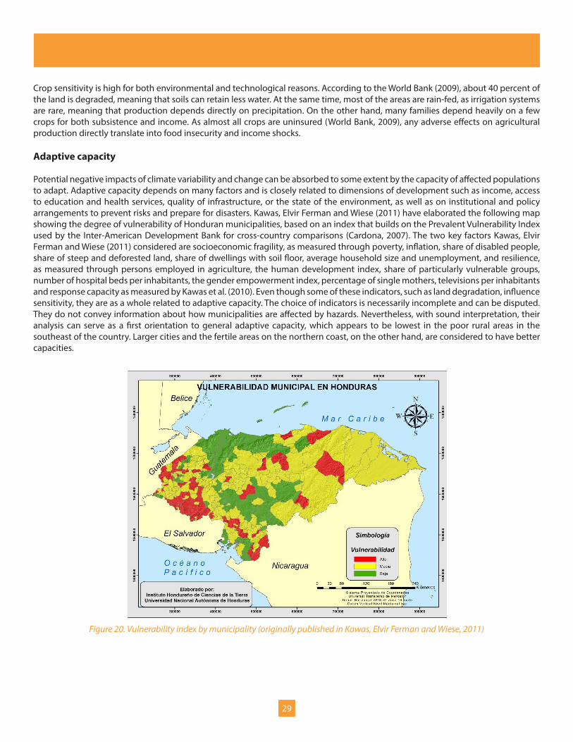
29
Crop sensitivity is high for both environmental and technological reasons. According to the World Bank (2009), about 40 percent of the land is degraded, meaning that soils can retain less water. At the same time, most of the areas are rain-fed, as irrigation systems are rare, meaning that production depends directly on precipitation. On the other hand, many families depend heavily on a few crops for both subsistence and income. As almost all crops are uninsured (World Bank, 2009), any adverse effects on agricultural production directly translate into food insecurity and income shocks.
Adaptive capacity
Potential negative impacts of climate variability and change can be absorbed to some extent by the capacity of affected populations to adapt. Adaptive capacity depends on many factors and is closely related to dimensions of development such as income, access to education and health services, quality of infrastructure, or the state of the environment, as well as on institutional and policy arrangements to prevent risks and prepare for disasters. Kawas, Elvir Ferman and Wiese (2011) have elaborated the following map showing the degree of vulnerability of Honduran municipalities, based on an index that builds on the Prevalent Vulnerability Index used by the Inter-American Development Bank for cross-country comparisons (Cardona, 2007). The two key factors Kawas, Elvir Ferman and Wiese (2011) considered are socioeconomic fragility, as measured through poverty, inflation, share of disabled people, share of steep and deforested land, share of dwellings with soil floor, average household size and unemployment, and resilience, as measured through persons employed in agriculture, the human development index, share of particularly vulnerable groups, number of hospital beds per inhabitants, the gender empowerment index, percentage of single mothers, televisions per inhabitants and response capacity as measured by Kawas et al. (2010). Even though some of these indicators, such as land degradation, influence sensitivity, they are as a whole related to adaptive capacity. The choice of indicators is necessarily incomplete and can be disputed. They do not convey information about how municipalities are affected by hazards. Nevertheless, with sound interpretation, their analysis can serve as a first orientation to general adaptive capacity, which appears to be lowest in the poor rural areas in the southeast of the country. Larger cities and the fertile areas on the northern coast, on the other hand, are considered to have better capacities.
Figure 20. Vulnerability index by municipality (originally published in Kawas, Elvir Ferman and Wiese, 2011)
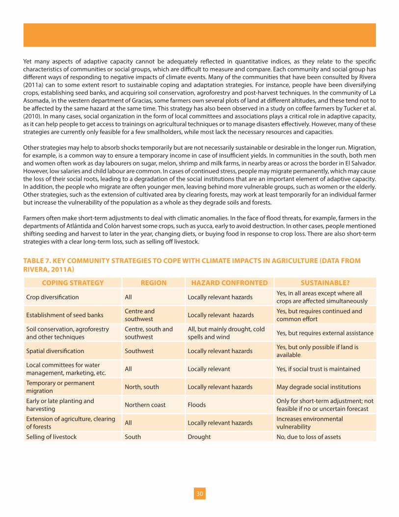
30
Yet many aspects of adaptive capacity cannot be adequately reflected in quantitative indices, as they relate to the specific characteristics of communities or social groups, which are difficult to measure and compare. Each community and social group has different ways of responding to negative impacts of climate events. Many of the communities that have been consulted by Rivera (2011a) can to some extent resort to sustainable coping and adaptation strategies. For instance, people have been diversifying crops, establishing seed banks, and acquiring soil conservation, agroforestry and post-harvest techniques. In the community of La Asomada, in the western department of Gracias, some farmers own several plots of land at different altitudes, and these tend not to be affected by the same hazard at the same time. This strategy has also been observed in a study on coffee farmers by Tucker et al. (2010). In many cases, social organization in the form of local committees and associations plays a critical role in adaptive capacity, as it can help people to get access to trainings on agricultural techniques or to manage disasters effectively. However, many of these strategies are currently only feasible for a few smallholders, while most lack the necessary resources and capacities.
Other strategies may help to absorb shocks temporarily but are not necessarily sustainable or desirable in the longer run. Migration, for example, is a common way to ensure a temporary income in case of insufficient yields. In communities in the south, both men and women often work as day labourers on sugar, melon, shrimp and milk farms, in nearby areas or across the border in El Salvador. However, low salaries and child labour are common. In cases of continued stress, people may migrate permanently, which may cause the loss of their social roots, leading to a degradation of the social institutions that are an important element of adaptive capacity. In addition, the people who migrate are often younger men, leaving behind more vulnerable groups, such as women or the elderly. Other strategies, such as the extension of cultivated area by clearing forests, may work at least temporarily for an individual farmer but increase the vulnerability of the population as a whole as they degrade soils and forests.
Farmers often make short-term adjustments to deal with climatic anomalies. In the face of flood threats, for example, farmers in the departments of Atlántida and Colón harvest some crops, such as yucca, early to avoid destruction. In other cases, people mentioned shifting seeding and harvest to later in the year, changing diets, or buying food in response to crop loss. There are also short-term strategies with a clear long-term loss, such as selling off livestock.
TABLE 7. KEY COMMUNITY STRATEGIES TO COPE WITH CLIMATE IMPACTS IN AGRICULTURE (DATA FROM RIVERA, 2011A)
COPING STRATEGY REGION HAZARD CONFRONTED SUSTAINABLE?
Crop diversification All Locally relevant hazards Yes, in all areas except where all crops are affected simultaneously
Establishment of seed banks Centre and southwest Locally relevant hazards Yes, but requires continued and
common effort
Soil conservation, agroforestry and other techniques
Centre, south and southwest
All, but mainly drought, cold spells and wind Yes, but requires external assistance
Spatial diversification Southwest Locally relevant hazards Yes, but only possible if land is available
Local committees for water management, marketing, etc. All Locally relevant Yes, if social trust is maintained
Temporary or permanent migration North, south Locally relevant hazards May degrade social institutions
Early or late planting and harvesting Northern coast Floods Only for short-term adjustment; not
feasible if no or uncertain forecast
Extension of agriculture, clearing of forests All Locally relevant hazards Increases environmental
vulnerability
Selling of livestock South Drought No, due to loss of assets

31
In many cases, people need external support to cope and adapt adequately. In communities on the Caribbean coast, villagers said they lacked the know-how to properly construct and maintain flood-drainage systems. In the department of Yoro, farmers have received useful training about new crop varieties. Limited market access often constrains adaptive capacity. In many areas, access roads are poorly maintained. Farmers also often lack the skills and power to value, commercialize and distribute crops properly. In some communities in the western department of Intibucá, farmers would like to sell beans to buyers from El Salvador and Guatemala, but they lack market information and power to benefit adequately. In the southern community of Talpetate, people would like to sell fruits and nuts to diversify incomes, but cannot find a good market. More generally, many communities lack administrative, organizational and financial skills.
Rivera (2011a) found that communities whose livelihoods are based on smallholder agriculture with strong reliance on staples such as maize and beans show generally more knowledge on climate and have better response capacity than communities in coastal areas. Genders also differ in their adaptive capacity: women are more involved in activities related to the household and health, whereas men are more active in production and marketing, which leads to differences in adaptive skills. Rivera (2011a) also reports rape and mistreatment of women in emergency situations, which causes women to stay at home rather than to go a shelter in some areas.
In sum, adaptive capacity varies much between regions, communities and social groups. Smallholder farmers have generally low capacities, as they have low incomes and little access to education, health and other services as well as infrastructure. They often live on degraded lands and have limited ways to sell their produce. Nevertheless, they have developed effective coping strategies, such as crop diversification, soil conservation, agroforestry systems, seed banks, and local committees to deal with water management, commercialization of crops and disaster management. Yet while many smallholders are aware of the benefits of these strategies, most of them lack the resources and capacity to apply them properly.
CLIMATE THREATS TO KEY DEVELOPMENT OUTCOMES
The combination of high exposure and sensitivity to climate hazards with insufficient adaptive capacity leads to significant and increasing climate risk for smallholder agriculture. Key current and future climate impacts include:
y Lower and decreasing average yields of key crops such as maize and beans, because of the regular impacts of climate extremes, continued soil degradation, and increasing water scarcity caused by rising temperatures and, probably, decreasing rainfall as well as coastal erosion brought about by sea-level rise.
y Higher inter-annual variation of yields due to extreme events, the frequency and intensity of which could increase in the future, and because of higher crop susceptibility to plagues and diseases in the context of water stress.
y Destruction of crucial infrastructure, such as farms, irrigation systems, water storage and access roads, due to tropical cyclones and floods.
These impacts have indirect consequences, which may affect not only the smallholders, but the society and economy at large:
y Reduction in rural incomes from agriculture, which affects the entire value chain.
y Increased food insecurity due to lower crop yields as well as higher food prices.
y Rising malnutrition because of lower crop yields in general, but especially due to threat of a significant reduction in bean yields, which are the key source of protein for many Hondurans.
y Decreasing exports and increasing need for imports of affected crops.
Such impacts increasingly put the achievement of several key national and sectoral development objectives at risk:
y First and foremost, achieving the poverty reduction objectives of the national plan and country vision and the Millennium Development Goals is harder, because of lower incomes for smallholders, who make up a large proportion of the poor and extremely poor.

32
y Likewise, reducing inequality is more difficult.
y Attempts to reduce hunger and increase food security, as stated in the Millennium Development Goals, are directly challenged by reduced and less stable food production.
y Lower incomes may call into question social development goals such as increased coverage of basic education or better health, as poor families may lack the resources to access health services or buy school materials. They may be forced to have their children work in the field rather than attend school. Health objectives, such as reducing child mortality, can also be threatened by increased food insecurity and malnutrition.
y Reducing crime may be harder in the context of increased conflicts over scarce resources such as water or fertile land. Accelerated rural-to-urban migration without sufficient job creation in cities can also affect security in urban areas.
y Increased water scarcity will make the extension of rural water access and irrigation more difficult and expensive.
y Preserving environmental resources can become more difficult in the context of increased resource scarcity and degradation.
y Increasing the quantity, value and exports of the agriculture and food sector, especially of staple foods, as the ‘Public Sector Strategy on Agriculture and Food’ aims to do, is more difficult in the context of decreasing and more uncertain crop yields. As a consequence, overall GDP growth may also be affected.
y Institutional goals, such as improving land-use plans and managing watersheds, could be even harder to achieve if communities face social disintegration as a result of increasing resource conflicts and emigration. The longer it takes to put such plans into practice, the more difficult it will get to do so.
Several factors help turn local-level climate risks into threats to development at a larger level. First, taken together, agricultural smallholders represent 30 percent of total population and over half of the rural population, and many of them produce similar crops. Second, since climate hazards will increasingly exceed the coping capacity of communities, smallholders will, more and more, have to resort to unsustainable responses such as agricultural expansion and deforestation, which can in turn jeopardize other development goals and increase vulnerability. Third, the economy is not well-diversified. With moderate climate impacts, communities can resort to coping strategies such as short-term labour on large monocultures if their own crops are affected. Yet increasing impacts are more likely to affect different agricultural systems simultaneously, which can make traditional coping strategies useless.
Many of these risks are present already. For example, Hurricane Mitch caused damages worth almost three-quarters of annual economic production. In the future, increasing temperatures, probably decreasing rainfall, increasing sea level, and possibly increasing frequency and intensity of extreme events will lead to higher climate hazards. Continued population growth and agricultural expansion will increase exposure, and many trends in vulnerability are on the rise, too. Climate risk is therefore poised to increase. The next sections look at how risks are dealt with today and how risk management could be improved in the future.
Key messages: Climate impacts and risks
y Every year cyclones, floods and droughts claim dozens of lives, affect tens of thousands of people and/or causing millions of dollars of damages, especially in the agricultural sector.
y Climate change could increase many of these impacts, mainly because it exacerbates water scarcity. Key crops such as maize and beans are highly sensitive to projected temperature and rainfall trends. Sea-level rise can lead to coastal erosion, which may affect agricultural land.
y Smallholder farmers generally have low adaptive capacity. Farmers do have strategies to cope with climate risk, but climate variability and change is increasingly overwhelming coping capacity and may make the use of sustainable coping strategies less likely. For sustainable adaptation, smallholders often require external support.
y The combination of hazards and vulnerability leads to significant and increasing climate risks and can jeopardize the achievement of national and sectoral development goals, including poverty and inequality reduction, better education, health and security, access to water, economic growth, and increased agricultural production, value and exports.

33
INSTITUTIONS AND POLICIES FOR CLIMATE RISK MANAGEMENTAs in most countries, climate risk management is currently addressed from two main angles, disaster risk management and climate change adaptation. In addition, climate risk considerations have recently been mainstreamed into important national and sectoral policy documents. The following subsections describe the key institutions and policies for each of these domains.
DISASTER RISK MANAGEMENT
The Permanent Commission of Contingencies (COPECO) is the government agency responsible for disaster risk management in Honduras. Founded in its present form in 1990, it aims to coordinate the efforts of public, private and civil society actors in preventing and attending to emergency situations caused by natural phenomena and human activities (Honduras COPECO, 2011). Its main activities are to:
y Coordinate the national risk management system (SINAGER) during different stages of emergency.
y Establish policies and norms in risk management.
y Decree alerts and recommendations and issue emergency declarations.
y Capacitate and orientate the population at all levels (national, regional, local).
y Promote a culture of prevention at all levels.
y Establish and strengthen early-warning systems in the entire national territory.
y Identify the most vulnerable areas in the country and their needs to implement mitigation measures.
y Promote the correct application of the law governing SINAGER and other norms such as construction codes.
y Incentivize and support studies on risk management.
As Honduras’ disaster risk–management agency, COPECO implements the five priority actions of the Hyogo Framework for Action. 8 COPECO works through seven regional offices and supports community-level organizations such as the local emergency committees.
SINAGER was created in 2009 and aims to manage prevention and recuperation in order to reduce the risk from potential disasters provoked by natural phenomena and human activities. The legal framework governing SINAGER embraces a broad definition of risk management, which includes prevention, mitigation and adaptation to climate change, financial management of disaster risks, permanent and effective preparation, humanitarian aid and assistance, and rehabilitation and reconstruction of affected areas. It mandates risk evaluations for all public and private plans, in particular for national and sectoral development strategies and actions. It promotes decentralized and non-concentrated risk management. And it highlights the importance of citizen participation and gender mainstreaming (Kawas et al., 2010).
Honduras is a member of the regional Coordination Centre for the Prevention of Natural Disasters in Central America. The Centre belongs to the institutional framework for the Integration of Central American States (SICA); brings together the national emergency commissions of the seven Central American countries; promotes and coordinates international cooperation, knowledge exchange, technical and scientific assistance; and systematizes information around disaster risks. Its main policy instrument is the ‘Central American Policy on Integrated Disaster Risk Management’ (Coordination Centre for the Prevention of Natural Disasters and SICA, 2010), which establishes guidelines, directives and actions that are to be detailed in more specific plans, such as a five-year regional disaster reduction plan. Among the strategic themes of the policy are risk reduction in public investment; development and social compensation as a means to reduce vulnerability; environment and climate change; territorial management, governability and governance; and disaster management and recovery.
8 The Hyogo Framework for Action is a 10-year plan adopted by 168 United Nations member states in 2005 to reduce disaster risk. It identifies five priority actions: ensure that disaster risk reduction is a national and a local priority with a strong institutional basis for implementation; identify, assess and monitor disaster risks and enhance early warning; use knowledge, innovation and education to build a culture of safety and resilience at all levels; reduce underlying risk factors; and strengthen disaster preparedness for effective response at all levels (United Nations International Strategy for Disaster Reduction, 2011).

34
CLIMATE CHANGE
The national authority in charge of climate change issues is the Secretariat of Natural Resources and Environment (SERNA). SERNA is responsible for the implementation of international treaties (United Nations Framework Convention on Climate Change and Kyoto Protocol) and, through its National Directorate on Climate Change, has led the elaboration of national communications and of the National Strategy on Climate Change. The UNDP has provided crucial support to SERNA in the elaboration of documents. Inter-agency coordination is promoted through the Inter-Institutional Committee on Climate Change and its technical sub-body, the Inter-Institutional Technical Committee on Climate Change. A further sub-committee has recently formed that deals with adaptation in the agricultural sector and brings together governmental, international and academic organizations.
In line with the recently finalized ‘Second National Communication’ (Honduras SERNA, 2011b), the National Climate Change Strategy proposes lines of action for adaptation in a number of priority sectors (Honduras SERNA, 2011a), including water, agriculture and food security, forests and biodiversity, marine and coastal systems, health, risk management and hydro energy. As a framework for implementing proposed actions, an Action Plan for the period 2011 to 2015 has been elaborated. For agriculture, it prioritizes three activities:
y Selection and development of crop varieties and species that are resilient to drought, floods, higher temperatures and short cycles.
y Substitution of unsustainable agricultural practices by agroforestry systems, organic agriculture and agroecological systems (this action is mainly aimed at greenhouse gas emission reduction).
y Irrigation, soil humidity management and watershed management.
The climate change strategy also suggests a range of immediate actions in order to institutionalize and facilitate its implementation, such as capacity building at different levels, planning and coordination among institutions, planning of specific measures and integration with other socio-environmental themes within Central America. In addition, SERNA is in the initial stages of preparing a climate change law.
At the Central American level, a regional climate change strategy has recently been developed under the auspices of SICA and the Central American Commission for Environment and Development (CCAD). The strategy summarizes climate information and sectoral vulnerabilities and proposes six strategic areas, of which one is titled “Vulnerability and Adaptation to Climate Variability and Change, and Risk Management.” Nine strategic objectives with over 150 measures relating to disaster risk reduction, agriculture and food security, forest ecosystems and biodiversity, water, health, coastal-marine systems, tourism, indigenous people and public infrastructure are mentioned under this theme. Other strategic areas are mitigation; capacity building; education, awareness raising, communication and participation; technology transfer; and international negotiations and management (CCAD and SICA, 2010).
RECOGNITION OF CLIMATE RISK MANAGEMENT IN KEY POLICY DOCUMENTS
Climate change adaptation and risk reduction are referred to in key policy documents from the Honduran Government. The national plan and country vision (Honduras, República de Honduras, 2010) consider climate change as one of 11 strategic themes. On adaptation, the strategy mentions the development of monitoring and measurement systems, early-warning systems, new forms of soil use and agricultural production, construction codes, local risk management, preventative land-use planning, water storage and watershed conservation as key measures. In the longer run, the Government recognizes that climate change should be mainstreamed into sectoral planning and into all public and private investment decisions. Climate change is also mentioned as a cross-cutting issue under other strategic themes such as “Regional Development, Natural Resources and Environment.” Disaster risks and environmental vulnerability are considered a threat to poverty reduction. In the longer run, climate risks are meant to be included in public finances. The Ministry of Finance has started working on this. Furthermore, the plan contains a set of strategic objectives, one of which is to reduce climate risk as measured by the Global Climate Risk Index (Harmeling, 2010). According to this index, Honduras is currently the third-most-vulnerable country in the world. The Government wants the country to drop to number 50 in this ranking.
The Ministry of Planning, which coordinates the implementation of the national plan and country vision, is also promoting the mainstreaming of climate change into municipal and regional development plans and territorial planning. They are currently developing a tool that assists their staff in the mainstreaming process.

35
The ‘Public Sector Strategy on Agriculture and Food’ of the Ministry for Agriculture and Livestock (Honduras SAG, 2010) also recognizes climate risks as an important factor. For example, it acknowledges the vulnerability of smallholders to climate variability and the negative impacts of a potential climate crisis on food security. However, apart from the aim of implementing a certain number of unspecified obligations under the United Nations Framework Convention on Climate Change, the strategy does not specify objectives or actions to reduce climate risks in the agricultural sector.
CLIMATE RISK MANAGEMENT ACTIVITIES
Since Hurricane Mitch hit Honduras in 1998, disaster risk management has gained increasing attention in Honduras. Numerous activities have been implemented by government agencies, international organizations and non-governmental organizations. Currently, one of the most important initiatives is the Disaster Preparedness Programme of the European Community Humanitarian Aid Office, which has focused on preparation and response-capacity building in vulnerable communities. The Red Cross and UNDP have also been involved in activities. Both of them have been combining disaster risk reduction and climate change adaptation approaches in their most recent projects.
Honduras has also attracted a lot of climate change adaptation projects. So far, the country has mainly focused on research and capacity building. In agriculture, the Inter-American Institute for Global Change Research has been studying effective adaptation strategies of coffee growers in the face of climate shocks. The United Nations Food and Agriculture Organization (FAO) is involved in the regional Special Programme for Food Security (PESA) project (FAO, 2010) which, among other things, looks at food security and climate change. The Inter-American Institute for Cooperation for Agriculture is establishing a national hub for its Intergovernmental Program on Opportunities and Challenges for Agriculture in the Context of Climate Change, which aims at fostering capacities for managing adaptation processes in agriculture. Honduras has also been one of the first countries to get approval for a project financed by the Adaptation Fund. The approved proposal focuses on reducing climate change risks related to water stress in urban areas around Tegucigalpa (Adaptation Fund, 2011).
Numerous activities have been implemented in the agriculture sector, with the involvement of SAG, among other institutions, that contribute to climate risk reduction but have not been explicitly labelled as either adaptation to climate change or disaster risk–reduction activities.
ASSESSMENT OF CLIMATE RISK MANAGEMENT CAPACITY
Based on the World Resources Institute’s ‘National Adaptive Capacity Framework’ (World Resources Institute, 2009), we have conducted a short desk-based capacity assessment on climate risk management functions. The framework evaluates capacities based on the availability of risk assessments and the capacity to conduct them, as well as their systematization and mainstreaming; the existence of explicit risk management priorities and a process to revise these priorities; the existence of coordination processes and bodies; the sound management of information; the identification of risks for priority areas; and the evaluation of adaptation options and their implementation.
Assessment. Numerous evaluations of climate vulnerability, impacts and risks have been conducted in Honduras. For example, the National Climate Change Strategy looks at key hazards, drivers of vulnerability and impacts for a range of important sectors. Participatory tools have been applied to assess risks at the community level. Rivera (2011a) summarized the results for 20 communities as an input for the present report. Evaluations have often been conducted with strong stakeholder participation. The assessments presented in the National Climate Change Strategy, for instance, were based on the discussion of sectoral focus groups. However, important gaps remain. Few quantified assessments exist regarding both current and future hazards and vulnerabilities. There is a need to conduct evaluations that cover entire sectors or regions but nevertheless provide specific results that can lay the basis for targeted interventions.
Prioritization. Whereas no explicit priorities have been identified in disaster risk management, the National Climate Change Strategy and its Action Plan do list strategic objectives and priority actions for a number of relevant sectors. These are based on qualitative vulnerability and impact assessments, as well as on the national development priorities enunciated in the national plan and country vision. Both the vulnerability assessments and the prioritization of adaptation options have been consolidated through expert roundtables, and we can assume that experts brought in local-level information. However, no process has been set up to ensure the integration of sectoral objectives into relevant public and private policies and actions, or to revisit priorities periodically. And while

36
the strategy mentions some guidelines for financing, no resources have been explicitly allocated, and it is uncertain whether SERNA as the coordinating mechanism has the necessary political weight to ensure these resources will be made available. Finally, climate change adaptation has not been thoroughly integrated with disaster risk reduction, and so the prioritized actions may not reduce vulnerabilities coherently and comprehensively.
Coordination. The Honduran Government has acknowledged and addressed the need to establish coordination processes and bodies both vertically and horizontally, at least to some extent. For disaster risks, the recently created SINAGER brings together relevant actors at all levels and designates COPECO as its coordinating body. For climate change, the also recently created National Directorate on Climate Change performs a similar function. The Inter-Institutional Committee on Climate Change has been set up to promote coordination among relevant government agencies. However, important deficiencies remain. Vertical coordination between the national and local levels appears to be established for disaster risk management, but not for climate change adaptation. Exact mandates, appropriate authority of the coordinating bodies, sufficient financial resources, and skills and knowledge among involved staff are largely lacking. And finally, the coordination between climate change and disaster risk management itself has not been institutionalized properly. Although each community mentions the other as a cross-cutting theme in their documents, no clear integration of disaster prevention and mitigation exists with adaptation to climate change.
Information management. Climatic, environmental, demographic and other relevant data are being gathered continuously in Honduras, but not in sufficient detail. As noted in the climate profile, weather data is scant and hasn’t been evaluated properly. For instance, observed climate trends and return periods of extreme events have not been analysed, because of lack of data and capacity. Vulnerability data is hard to come by as well. For example, the recent study by Kawas et al. (2010) on disaster response capacity at national and municipal levels found that there had been a complete lack of systematized data on relevant variables. The vulnerability map presented in the climate risk profile is the first of its kind in Honduras. Much data is difficult to access and not collected and disseminated centrally, but distributed among many different institutions (Kawas et al. 2010). Climate information management can therefore be considered a particularly important obstacle in the path to effective climate risk management at different levels.
Climate risk reduction. The last element considered in the ‘National Adaptive Capacity Framework’ is the climate risk reduction function, which captures elements of the previous functions but focuses more precisely on the identification of specific risks to given priorities and the evaluation of adaptation and risk-reduction options, as well as their selection and implementation. As noted above, climate risk assessments have been conducted for several sectors, but they have been quite general and not based on detailed methodologies. Similarly, adaptation options have been identified, but have rarely been defined in detail. No cost analyses, evaluations of environmental and social implications, timelines, or review processes exist, for example. For risk prevention, no specific actions have been prioritized. On implementation, while multiple actors are contributing to climate risk reduction, no systematic implementation of the actions prioritized in the National Climate Change Strategy has occurred so far. The Government is only in the process of establishing mechanisms and allocating resources.
Key messages: Institutions and policies for climate risk management
y Honduras has a comprehensive national risk management system and a clearly designated coordinating authority, COPECO. The equivalents for climate change adaptation are SERNA’s National Directorate on Climate Change and the Inter-Institutional Committee on Climate Change.
y Key policy documents such as the national plan and country vision recognize climate risks as a development issue; however, no thorough mainstreaming has occurred for key policies such as the Public Sector Strategy on Agriculture and Food.
y Numerous activities are ongoing in both disaster risk reduction and climate change adaptation. The former picked up after the Hurricane Mitch disaster in 1998. The latter have mainly focused on research and capacity building so far. Many gaps remain.
y Honduras has recently improved its capacity for climate risk management, but deficiencies remain in terms of vulnerability and risk assessments, prioritization procedures for risks and risk management options, coordination among disaster risk and climate change adaptation agencies, information management and implementation of climate risk–management actions.

37
RECOMMENDATIONS FOR CLIMATE RISK MANAGEMENTClimate variability and change can pose significant threats to smallholder agriculture and larger development objectives, yet many impacts can be minimized if conditions of vulnerability are improved and adaptive capacity is strengthened at national, regional and local levels. Based on the risk and capacity analyses presented above, this section outlines key recommendations for specific actions at the local level, adjustments in policies and institutions to facilitate action and research, and avenues for future research.
ACTIONS
The following proposals for actions to reduce climate risk to smallholder agriculture were mostly identified by stakeholders of the agriculture sector in participatory scenario development workshops9 as part of the CRM TASP. The workshops focused on four regions:10 the Valle de Sula (northwest), Valle de Aguan and Caribbean coast, the south, and Lempa (southwest). Actions fall under eight themes: local governance and social organization; territorial planning; water management; soil management; finance and insurance; infrastructure; climate data and information; and capacities.
Local governance and social organization
As highlighted in the risk assessment above, local governance and social organization can reduce climate risk by increasing the adaptive capacity of communities. For example, (micro-) watershed councils with the participation of all relevant actors, including civil society, private enterprise and local authorities, can improve the management of increasingly scarce water resources and thereby reduce the risk of crop failures. Protecting watersheds can also reduce the severity of droughts and floods thanks to improved water retention. Smallholder associations can help identify and share good practices in agriculture (see below), increase access to financing and markets, and improve administration and commercialization of agricultural produce. Strengthened economic resources will in turn facilitate risk diversification and allow farmers to survive through times of stress. Access to financial instruments such as insurance and credit also allows for risk transfer. Local disaster management committees elaborate emergency plans, build local capacities, establish principles of early recovery, conduct emergency drills and cooperate with other organizations such as watershed councils (Kawas et al., 2010), and can thereby improve preparedness for disasters. They can also help to integrate climate risk management into local development plans. Women’s associations can tackle gender gaps and strengthen women’s capacities, and can thereby reduce gender-based vulnerability.
Improving local governance was identified as a key area by the group looking at the northwestern Valle de Sula, but appears to be a necessity across the country. Establishing watershed councils is particularly important in the drought-affected areas of the south and west. Supporting farmer associations is more crucial in poor and remote areas, particularly of the southwest. Finally, strengthening local disaster management committees is more urgent in municipalities where response capacity is still weak. The evaluation of municipal response capacity by Kawas et al. (2010) can serve as a guide to direct efforts.
In the short term, improving local governance will require awareness raising and capacity building on climate, hydrology, environment and other important aspects among the target population. The dialogue between different stakeholders, both horizontally and vertically, has to be promoted, with a particular view to integrating the most vulnerable social groups. Once councils function properly, concepts such as payment for ecosystem services can be introduced in order to promote watershed protection, for instance. A favourable enabling environment is needed throughout the process of improving local governance. Unequal power relations, for example between private enterprises and smallholders, can render it impossible for a local council to function properly (Rivera, 2011b). Yet national policies and interventions can incentivize local organization, for example by strengthening value chains or promoting trade fairs, in the case of farmer associations, or by establishing and enforcing laws on water use.
Local organizations and social trust are also crucial for conflict resolution. Climate stresses and shocks render important livelihood resources such as water and land more fragile and scarce. As a result, conflicts can arise between different users. It is therefore important to invest in governance early enough, as vicious circles of increased vulnerability and resource conflicts may be unstoppable at an advanced stage.
9 See introduction for more details.10 See chapter 2 for a map of the regions of Honduras.

38
Territorial planning
Land-use regulations should be improved and enforced, with a view to maximizing productivity over the long run, protecting the environment and minimizing disaster risks. Achieving this will require a complete reversal of current practices in most areas, as people often don’t hold land titles, and agricultural expansion occurs unchecked. Honduras has a law for territorial planning, but it should consider climate risk more adequately by taking into account hazards and vulnerabilities as well as climate trends. This, as well as proper implementation through enforced regional and municipal development plans, facilitated by local-level risk mapping, land-use zoning and development regulations, could free the way to many improvements important for risk reduction, such as investments in irrigation or crop diversification, which are not made in the context of uncertainty over land tenure (Rivera, 2011a). It would also allow use of available land to its full potential, by taking current and future climatic conditions into account, and designate protected areas such as water catchment zones.
Barriers to territorial planning can be mainly found in the low political will to take on the issue. Communities feel that private sector interests have often stood in the way of sustainable solutions, but insist that land titles and fairer rules would increase social and economic stability and thereby improve resilience. The importance of territorial planning was particularly highlighted by the workshop groups looking at solutions for the north and south of the country. Improving and enforcing territorial planning is a long and complex process because of the strong political dimension, but the potential benefits are enormous and not confined to climate risk reduction only. The elaboration of plans has to involve local partners as much as possible to ensure ownership.
Water management
Considering the overarching importance of water for agriculture, regional groups highlighted the increasing importance of water management in the face of a drier future. They propose the establishment of micro-irrigation systems, norms for water extraction and use, protection of water sources, payments for ecosystem services,11 and water-retention systems, including those for rainwater harvesting. Water extraction and use must be managed at the level of (micro-) watersheds, taking into account current and future precipitation, slopes, water sources, surface, population, irrigated parcels and water-retention systems. There needs to be awareness raising and incentives for rational water use (Rivera, 2011b). Watershed protection also involves reforestation and the protection of wetlands. Members of the southern community of Talpetate suggested establishing tree and plant nurseries with a view to fostering reforestation in the catchment area. In Marcovia, another southern community, consulted inhabitants proposed to pay for work in environmental protection during winter, the most difficult period of the year in terms of food security, when most of the deforestation also seems to occur (Rivera, 2011a).
The crop impact study conducted by Medeiros and McCandless (2011) confirms the importance of adequate irrigation for climate risk management. Their modelling results indicate that the negative impacts of climate change can be offset for beans and that maize yields can even be greatly enhanced if crops receive an optimal amount of water. Average modelled yields of irrigated maize crops were 44 percent higher in 2025 and 27 percent higher in 2025 compared with non-irrigated treatment in 2000. For beans, yields with irrigation in 2025 were 9 percent higher than with no inputs in 2000. However, average yields in 2050 were five percent lower, even with irrigation. Still, compared with the projected loss of 32 percent with no treatment, irrigation can still offset average yield losses by 27 percentage points. The different scenarios for lowland maize production are shown in figure 21 below.
Obstacles to better water management are manifold and include governance-related challenges (see above). The requirement of financial resources can be a barrier, too. Low-cost techniques such as micro-irrigation systems exist, however, and these can be implemented more easily and quickly (Rivera, 2011a). Currently drought-prone areas in the south and west of the country should be prioritized; however, over the coming decades the entire country will become more arid, which should be taken into account in longer-term investments.
11 Honduras already has a National Strategy on Environmental Goods and Services.

39
Figure 21. Maize yields under different crop management scenarios (originally published in Medeiros and McCandless, 2011)
Soil management and agricultural practices
As a complement to water management, workshop groups also proposed a range of measures for improving agricultural practices and soil management. These practices are expected to improve medium- and long-term yields, irrespective of climate risks.
Fertilizer use. In the context of soil management, Medeiros and McCandless (2011) reveal the potential of nitrogen fertilizer to absorb part of the negative shock imposed by climate change on maize production. Yields for 2025 with fertilizer treatment were 8 percent higher than 2000 yields without treatment. For 2050, climate impacts cannot be fully compensated anymore, but the loss can be mitigated to 5 percent compared with 12 percent with no treatment (for lowland maize, see figure 21 above). For beans, however, the benefits of fertilizing were limited, mainly because beans can fix nitrogen directly from the atmosphere. Fertilizer use is any case a two-edged sword. Rivera (2011a) reports that communities often do not know how to use fertilizer well, and as a result may even contribute to soil degradation, for instance by applying too much fertilizer. Organic methods, such as compost-based fertilizer, should be preferred, and farmers need training in proper fertilizer use.
Soil conservation practices. Agricultural practices such as reduced tillage, mulching, compost application, live barriers, contour farming, agroforestry and agropastoralism, seed banks, reforestation, reduced agricultural burning, and other methods such as crop rotation and the adjustment of seeding and harvesting calendars contribute to soil conservation and are crucial for maintaining and improving crop yields, as deeper soils can trap more water. Crop simulations by Medeiros and McCandless (2011) could not analyse these practices in detail, but they showed that yield losses were generally larger for crops grown on soils less than 30 cm deep. In addition, irrigation led to greater yield increases for crops on shallow soils, which points to limitations in the ability of shallow soils to retain rain water. Rich and stable soils reduce climate risks not only by aiding higher productivity, but also because they can reduce the risks of landslides and downstream floods. As Thurow, Thurow and Santos (2004) highlight, adopting a watershed approach to soil conservation on cropped steeplands in rural Honduras, for instance through physical or live barriers, can reduce the landslide hazard to negligible levels. Community consultations indicated that farmers understand the need for better agricultural practices to conserve soils (Rivera, 2011a).
0
5
10
15
20
25
30
0
1000
2000
3000
2000
2025
2050
2000
2025
2050
2000
2025
2050
2000
2025
2050
Florida, CO San A. deCortes, CT
La Montana,CH
El Carrizal, EP
Tem
pera
ture
in °C
Mai
ze y
ield
in k
g/ha
an
d pr
ecip
titio
n in
mm
Modelled average maize yields at lowland Honduras sites with no inputs, perfect irrigation, perfect fertilzation at present and with climate change
No Inputs
Irrigation
AveragePrecipitationAverageTemperature
40
Crop diversification. A diversified set of crops can reduce the risk of crop losses if the chosen crops are not affected in the same way by different climate hazards and other shocks, such as price fluctuations. Ideally, diversification brings in more resistant crops such as cassava and sorghum (Medeiros and McCandless, 2011), and new varieties of currently grown crops, such as beans and maize. The adequacy of existing and new crops depends on the climatic region. Farmers in the department of Yoro, for instance, proposed growing vegetables such as cabbage, tomatoes, chiles, potatoes, onions and beetroots as a way to become more resilient. Diversification can also involve owning plots of land at different altitudes, with consequently differing exposure to climate hazards (Rivera, 2011a). There are important obstacles to diversifying crops. Diversification is difficult if space is limited. As a study by Tucker et al. (2010) showed, coffee farmers who own spare land are more likely to diversify crops, as they do not face the same critical decision as others of giving up existing crops for others. Such a decision is particularly difficult if it involves moving from annual to perennial crops or vice-versa, as such a move is not easily reversible. If a farmer is sticking to annual crops, crop rotation can offer a way to combine continuous production with diversification (Rivera, 2011a). Another challenge relates to introducing more resistant varieties and new crops. In several cases the Government, sometimes with the assistance of international donors, has tried to introduce more resistant seeds, but people have not liked the taste. There is thus a need to ensure the cultural acceptance of new varieties. Farmers in the department of Francisco Morazán mentioned accepted varieties of maize (malake) and beans (chinapopo), which are more resistant. Chinapopo is especially interesting from a climate risk perspective, as it grows in winter and can help to bridge a critical gap for food security. Other farmers pointed to rice and yucca as accepted alternatives for new crops (Rivera, 2011a).
Agroforestry. Agroforestry offers particular advantages in the context of climate risk reduction. Agroforestry systems involve a combination of soil and water management techniques and a choice of agricultural and forest crops. Therefore, they offer several of the benefits mentioned above. Thanks to richer and moister soils, productivity is higher. Trees protect crops from hazards such as landslides and winds. A wide diversity of crops can be grown, including traditional staple crops such as maize and beans, as well as coffee. Agroforestry is already practiced in Honduras and promoted by development agencies such as the FAO (2010). Participatory scenario development workshop participants highlighted an interest in growing more cacao, bananas, yucca, fruit, coaba and maize under agroforestry (Rivera, 2011b).
Finance and insurance
Financial instruments, such as access to credit and insurance, can help to transfer and spread climate risks for farmers. Weather insurance, for example, can reduce the risk of income loss in case of pre-defined hazards such as ENSO conditions or cyclones. Access to credit allows farmers to survive through bad years and to invest in risk-reducing measures such as irrigation. The Government currently subsidises 50 percent of insurance premiums for corn. Other public and private initiatives to promote insurance for agriculture are underway (World Bank, 2009). Yet many smallholders do not have access to such facilities, due to gaps in education, information and communication, and to the lack of profitability for financial institutions to serve smallholders.
Infrastructure
Participatory scenario development workshop participants saw safe infrastructure, in particular considering hazards such as floods and landslides, as a priority in climate risk management. Among other things, the implementation of adequate norms and construction codes is needed to achieve this. The Ministry of Planning is already promoting the climate proofing of projects for agricultural production and is elaborating an assessment tool. Better infrastructure reduces risks directly, as it is less sensitive to climate hazards. It can also increase adaptive capacity and the exploration of alternative adaptive strategies. Roads, for instance, ensure market access and allow farmers to sell diversified crops. Corruption was identified as a key barrier for safer infrastructure. Participants mentioned that construction firms would build weak infrastructure in order to ensure further contracts as the works degrade (Rivera, 2011b). Financing is also a key obstacle.

41
Climate data and early-warning systems
As noted in the climate profile above, many gaps remain in relation to collecting, monitoring and tracking climate data and information, ranging from patchy weather data to lack of sea-level observations. Investments are needed in better coverage by weather stations and their continuous functioning. Data analysis and interpretation, including of forecasts and the return periods of extreme events, needs to be strengthened. Data and information should be centralized to avoid duplication and contradiction, and access should be facilitated. Related to this, early-warning and weather-prediction systems should be developed further. Sectoral agencies, local governments and farmers in particular need access to timely information about storms, floods and droughts as well as about expected rainfall quantities and timing for each season. This will allow them to manage climate risks more adequately, in the short term by planning both planting and harvesting better and by preparing for emergencies, and in the long term by adjusting strategies and development plans. Climate data and early-warning systems should also be interconnected with systems at the regional level.
Capacity development
Many of the measures mentioned above require capacity building at the local and national levels. Communities need to learn how to properly build, maintain and use water-retention systems and other relevant infrastructure properly (Rivera, 2011b). The same applies to soil management and agricultural best practices, including the establishment of seed banks and agroforestry systems. Farmers also need to understand weather and climate data better and have access to updated information for agricultural planning (Rivera, 2011a). A further key focus of capacity development measures should be on valuation and local and international commercialization of agricultural produce. This applies in particular to new, diversified crops, which farmers do not yet know where and how to commercialize. The promotion of small-scale rural enterprises can unlock the farmers’ potential to participate more easily in markets.
Members of the southern community of Talpetate, for instance, said they could produce juice with the nance fruit and could create a microenterprise to produce and sell it. However, they first need to acquire the skills to do so. In the department of Intibucá, farmers grow more resistant black beans, but lack the market knowledge and power to commercialize them with adequate benefit in neighbouring El Salvador and Nicaragua. Creating savings and managing credit within cooperatives also requires training (Rivera, 2011a).
Capacity building is also needed for local administrations and nodal agencies that connect with national-level administrations such as the Ministry for Agriculture. Finally, efforts should be structured to ensure that the most vulnerable groups, including women, benefit from them as well. They do not need to involve vertical technology transfer, but can make use of knowledge exchanges between communities (Rivera, 2011a).
Prioritized climate risk management actions
Table 8 summarizes prioritized risk management options mentioned above by strategic theme. The third column indicates the expected benefits, and the last column explains what regions should be prioritized. Note that most actions are needed in all regions, and the specific needs vary from one community or region to another.12
Note that table 8 only contains actions that directly or indirectly support risk reduction in the agricultural sector. Since the sector is particularly sensitive to climate variability and change, a shift to other income-generating activities can reduce risk both at the local and economy-wide levels. However, no such strategies were discussed in the context of the CRM TASP in Honduras.
12 See ‘Development Profile’ for a map of the regions of Honduras (p. 14).
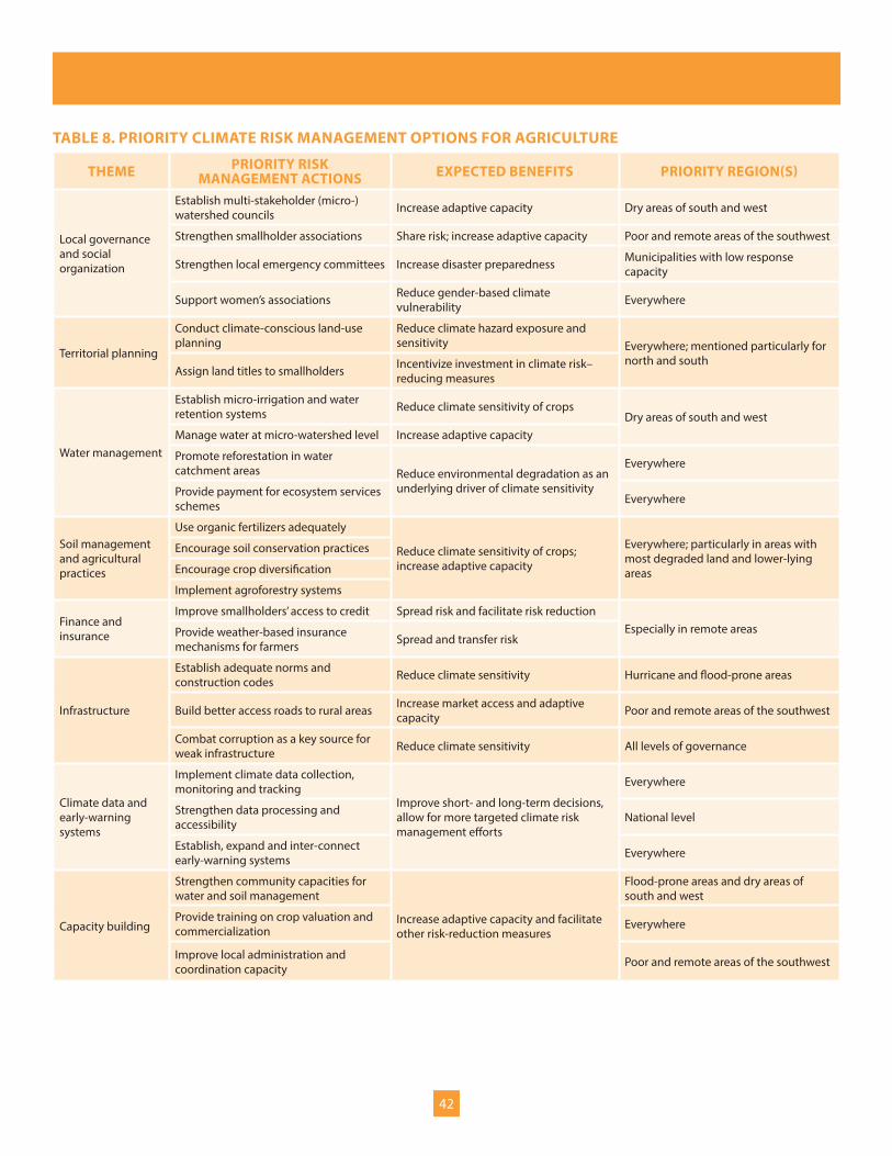
42
TABLE 8. PRIORITY CLIMATE RISK MANAGEMENT OPTIONS FOR AGRICULTURE
THEME PRIORITY RISK MANAGEMENT ACTIONS EXPECTED BENEFITS PRIORITY REGION(S)
Local governance and social organization
Establish multi-stakeholder (micro-) watershed councils Increase adaptive capacity Dry areas of south and west
Strengthen smallholder associations Share risk; increase adaptive capacity Poor and remote areas of the southwest
Strengthen local emergency committees Increase disaster preparedness Municipalities with low response capacity
Support women’s associations Reduce gender-based climate vulnerability Everywhere
Territorial planning
Conduct climate-conscious land-use planning
Reduce climate hazard exposure and sensitivity Everywhere; mentioned particularly for
north and southAssign land titles to smallholders Incentivize investment in climate risk–
reducing measures
Water management
Establish micro-irrigation and water retention systems Reduce climate sensitivity of crops
Dry areas of south and westManage water at micro-watershed level Increase adaptive capacity
Promote reforestation in water catchment areas Reduce environmental degradation as an
underlying driver of climate sensitivity
Everywhere
Provide payment for ecosystem services schemes Everywhere
Soil management and agricultural practices
Use organic fertilizers adequately
Reduce climate sensitivity of crops; increase adaptive capacity
Everywhere; particularly in areas with most degraded land and lower-lying areas
Encourage soil conservation practices
Encourage crop diversification
Implement agroforestry systems
Finance and insurance
Improve smallholders’ access to credit Spread risk and facilitate risk reductionEspecially in remote areasProvide weather-based insurance
mechanisms for farmers Spread and transfer risk
Infrastructure
Establish adequate norms and construction codes Reduce climate sensitivity Hurricane and flood-prone areas
Build better access roads to rural areas Increase market access and adaptive capacity Poor and remote areas of the southwest
Combat corruption as a key source for weak infrastructure Reduce climate sensitivity All levels of governance
Climate data and early-warning systems
Implement climate data collection, monitoring and tracking
Improve short- and long-term decisions, allow for more targeted climate risk management efforts
Everywhere
Strengthen data processing and accessibility National level
Establish, expand and inter-connect early-warning systems Everywhere
Capacity building
Strengthen community capacities for water and soil management
Increase adaptive capacity and facilitate other risk-reduction measures
Flood-prone areas and dry areas of south and west
Provide training on crop valuation and commercialization Everywhere
Improve local administration and coordination capacity Poor and remote areas of the southwest

43
GOVERNANCE
The priority actions and research needs identified here require adequate institutions at the national level to enable and facilitate their implementation. As the capacity assessment in the previous section shows, Honduras has a good basis for sound climate risk management, thanks to proper designation of coordination bodies and processes, existing climate risk assessments and prioritization of actions, and risk reduction action that is already occurring. However, improvements along the following three themes are required: Mainstreaming of climate risk into key public policy documents, implementing public policies and building capacity.
Both the national plan and country vision and the ‘Public Sector Strategy on Agriculture and Foods’ acknowledge climate risk as an important factor. Yet the mainstreaming of climate risk management remains rather superficial, especially in the ‘Public Sector Strategy on Agriculture and Food.’ Many of this document’s objectives are directly affected by climate risks. For example, its main goal, rural poverty reduction, will be much harder in the context of climate impacts such as crop and income losses. Decreasing yields of maize and beans will make increasing their production, another objective, more difficult. We therefore recommend that climate risks be considered much more thoroughly at all levels of the strategy. In particular, we recommend the following changes:
y Acknowledge specific impacts of both climate variability and change on the agriculture and food sector, such as the expected yield reductions for maize and beans.
y Make vulnerability reduction a key goal of the strategy, along with poverty reduction.
y Acknowledge the challenges posed by climate risk to the achievement of all specific objectives and propose practical steps to overcome them, such as those proposed in the previous section.
y Propose support measures for local agriculture in places where it can survive. This can include better access to training, seeds, marketing and value chains.
y Acknowledge and address the underlying risk drivers, such as the increasing conflict of vulnerable smallholders with large-scale monocultures and livestock breeding, which push smallholders onto ever-more-vulnerable lands.
y Link the policy explicitly to the National Strategy on Climate Change as well as regional strategies and the action themes mentioned there.
Mainstreaming should also occur at other levels of government, as well as in other policy areas relevant for agriculture, such as water resources, territorial planning and finance. It should involve the earmarking of resources for areas and sectors that are impacted by climate variability and change. Different ministries are beginning to take steps in this direction.
In many cases, good public policies fail in the implementation stage. Honduras has a set of sound laws and policy documents, such as the new law on the National Risk Management System or the National Climate Change Strategy with its action plan. These laws and policies, however, need to be implemented thoroughly and in coordination with other relevant entities. Numerous obstacles stand in the way, including the lack of financial and human resources, the low political weight of climate risk management agencies, and weak governance in general. Both the Government itself as well as its donors now need to focus on implementation. Apart from the required capacity development efforts described below, adaptation to climate change and disaster risk reduction need to become a priority in public policy, and the efforts to improve governance at the local scale need to be mirrored with equal improvements at the national scale.
In order to support the implementation of action plans, relevant government agencies such as the National Directorate on Climate Change, COPECO and the National Meteorological Service need to see their capacities and powers strengthened at both the national and sub-national levels. They are understaffed and underfinanced. For example, few weather stations have a sufficiently long record to measure observed changes. Very few climatologists are available to conduct high-quality climate research. Furthermore, institutions such as SERNA and its climate change committees often lack the necessary political clout to make sure their recommendations are followed through. Vulnerability is related to political factors such as the conflict between large-scale monocultures and smallholder interests, which can only be settled in a fair way if both sides are heard in the political process.

44
There is also room for improvement in the coordination among agencies. Disaster risk management and climate change adaptation have only been loosely integrated so far. The National Climate Change Strategy, for instance, mentions disaster risk management as one priority sector, but doesn’t acknowledge the cross-cutting nature of disaster risk reduction for climate change adaptation in all other sectors. Another example is the lack of coordination with respect to gathering, analysing and providing access to climate and vulnerability data. Coordination is also important among different levels of governance, from intergovernmental committees to community-level organizations.
Linkages to international and regional agencies such as the CCAD and the Coordination Centre for the Prevention of Natural Disasters in Central America should be improved, with a view to more efficiently using scarce resources for monitoring and forecasting climate hazards, vulnerability and risk assessments, training and capacity building.
FURTHER RESEARCH
This report has identified a number of key issues around climate-related risks for smallholder agriculture and their implications for national development. However, there is still a need for further research in a range of areas. First of all, there is a need for more detailed knowledge about climate trends and extreme events, such as return periods and possible future projections. Risks and impacts also need to be studied further. For example, past correlations between weather data and crop outputs could be analysed. Crops such as coffee, sorghum or rice could be studied with regard to how climate change affects them. Looking at larger implications, the connections between climate risks and food security need to be explored, among other things. More research is also need with regard to more resistant varieties and agricultural practices as well as efficient irrigation technology, which can reduce vulnerability. Another issue identified in this study is plant diseases, which appear to be little understood and hard to cope with.
Universities need to be involved in these processes. First, working with national actors ensures much better ownership and context-specificity, and it increases the chances that research will lead to action. Universities have also an advantage compared with government institutions, in that the latter suffer from capacity loss with every new government, because of staff exchange.
Key messages: Recommendations for climate risk management
y To reduce climate risks for smallholder agriculture and the resulting threats to larger development objectives, efforts are needed to improve local governance and social organization, territorial planning, water management, soil conservation and agricultural practices, finance and insurance services, infrastructure, and climate data and early-warning systems, as well as to build respective capacities at the local level.
y With regard to policy and institutional improvements, climate risk should be mainstreamed more thoroughly into key public policy documents such as the Public Sector Strategy on Agriculture and Food. Relevant public policies should be properly implemented, especially measures reducing climate risk, not least through better governance. The capacities and political clout in the relevant government agencies needs to be strengthened, along with coordination among them.
y Further research is required on climate trends and extreme events; climate impacts and risks on crops, livelihoods and food security; and risk-management options such as drought resistant crops and irrigation technology, and should involve national research centres.

45
REFERENCESAdaptation Fund (2011). Addressing Climate Change Risks on Water Resources in Honduras: Increased Systemic Resilience and Reduced Vulnerability of the Urban Poor. Project/programme proposal. Available at http://www.adaptation-fund.org/sites/default/files/Hondorus%20Project_0.pdf
Aguilar, E. and others (2005). Changes in Precipitation and Temperature Extremes in Central America and Northern South America, 1961–2003. Journal of Geophysical Research, vol. 110, D23107. doi:10.1029/2005JD006119
Argeñal, F. (2011a). Análisis de Eventos Extremos en Tegucigalpa, Honduras. Working document. Proyecto de Apoyo y Asistencia Técnica en la Gestión del Riesgo Climático en Honduras. Winnipeg: IISD and Tegucigalpa: UNDP.
Argeñal, F. (2011b). Escenarios de Cambio Climático para el Año 2025 en Honduras. Working document. Winnipeg: IISD and Tegucigalpa: UNDP.
Argeñal, F. (2010a). Inventario de la Información Disponible sobre Amenazas, Vulnerabilidad y Riesgo Climático en Honduras. Working document. Winnipeg: IISD and Tegucigalpa: UNDP.
Argeñal, F. (2010b). Variabilidad Climática y Cambio Climático en Honduras. Honduras: Secretaría de Recursos Naturales y Ambiente and UNDP.
Bárcena, A. and others (2010). Economics of Climate Change in Latin America and the Caribbean. Summary 2010. Santiago de Chile: Economic Commission for Latin America.
Baumeister, E. (2010). Pequeños Productores de Granos Básicos en América Central. Cuantificación, Caracterización, Nivel de Ingresos, Pobreza, y Perfiles Demográficos, Socioeconómicos y Ocupacionales. Rome: FAO.
Bizikova L., S. Boardley, and S. Mead (2010). Economics of Adaptation to Climate change. Participatory Scenario Development (PSD) Approaches for Identifying Pro-Poor Adaptation Options. Discussion Paper Series No. 18. Washington, D.C.: World Bank.
Bizikova L., T. Dickinson, and L. Pinter (2009). Opportunities for Participation and Learning When Translating Impacts of Climate Change into Adaptations. Participatory Learning and Action, vol. 60, pp. 167–173.
Cardona, O.D. (2007). Indicadores de Riesgo de Desastre y Gestión de Riesgos: Programa Para América Latina y el Caribe; Informe Resumido. Washington, D.C.: Inter-American Development Bank.
Central American Commission for Environment and Development (CCAD) and Integration of Central American States (SICA) (2010). Estrategia Regional de Cambio Climático. Documento Ejecutivo.
Christensen, J. H. and others (2007). Regional climate projections. Pp. 847–940 in Climate change 2007: The physical science basis. Contribution of Working Group I to the Fourth Assessment Report of the Intergovernmental Panel on Climate Change, S. D. Solomon and others, eds. Cambridge, UK, and New York: Cambridge University Press.
Coordination Centre for the Prevention of Natural Disasters in Central America and Integration of Central American States (SICA) (2010, June). Política Centroamericana de Gestión Integral de Riesgo de Desastres (Central American Policy on Integrated Disaster Risk Management). Guatemala City: CEPREDENAC and Ciudad Merliot, El Salvador: SICA.
Harmeling, S. (2010). Global Climate Risk Index 2011. Who Suffers Most from Extreme Weather Events? Weather-Related Loss Events in 2009 and 1990 to 2009. Briefing paper. Bonn: Germanwatch.
Honduras, Comisión de la Verdad y la Reconciliación (2011). Para Que los Hechos No Se Repitan: Informe de la Comisión de la Verdad y la Reconciliación. Tomo I.

46
Honduras, Instituto Nacional de Estadistica (2009). Encuesta Agropecuaria Básica.
Honduras News (2010, April 5). Weekend Rain a Ray of Hope. Available at http://www.hondurasnews.com/tag/drought
Honduras, Permanent Commission of Contingencies (COPECO). (2011). Comisión Permanente de Contingencias. Retrieved 15 August 2011 from http://copeco.gob.hn
Honduras, República de Honduras. (2010, January). Visión de País 2010–2038 y Plan de Nación 2010–2022. Presentados Para Consideración del Soberano Congreso Nacional.
Honduras, República de Honduras. (2001). Poverty Reduction Strategy Paper.
Honduras, Secretaría de Agricultura y Ganadería (SAG) (2010). Estrategia del Sector Público Agroalimentario y Plan de Implementación. Honduras Hacia el Desarrollo Sustentable.
Honduras, Secretaría de Recursos Naturales y Ambiente (SERNA) (2011a). Estrategia Nacional de Cambio Climático Honduras.
Honduras, Secretaría de Recursos Naturales y Ambiente (SERNA) (2011b). Segunda Comunicación de Honduras Ante la Convención Marco de las Naciones Unidas sobre Cambio Climático.
Instituto Universitario en Democracia, Paz y Seguridad. (2011, March). Observatorio de la Violencia, Mortalidad y Otros. Edición No. 10. Tegulcigalpa: Universidad Autonoma Nacional de Honduras. Available at http://iudpas.org/pdfs/NEd20EneDic2010.pdf
Intergovernmental Panel on Climate Change (IPCC) (2001). Climate Change 2001: Impacts, Adaptation and Vulnerability. Cambridge, UK: Cambridge University Press.
International Fund for Agriculture Development (2010). Rural Poverty Portal: Honduras – Geography, Agriculture and the Economy. Rome. Retrieved 4 August 2011, from http://www.ruralpovertyportal.org/web/guest/country/home/tags/honduras
International Monetary Fund (IMF) (2011). Data and Statistics. Washington, D.C. Retrieved August 2011 from http://www.imf.org/external/data.htm
Kawas, N. (2011). Fuentes de Informacion de la Elevación del Nivel del Mar en Honduras. Working document. Winnipeg: IISD and Tegucigalpa: UNDP.
Kawas, N., and O. Elvir Ferman (2011a). Impactos de Tormentas Tropicales y Huracanes en Honduras. Un Resumen del Periodo 1968–2010. Working document. Winnipeg: IISD and Tegucigalpa: UNDP.
Kawas, N., and O. Elvir Ferman (2011b). Inventario de la Información Disponible Sobre Amenazas, Vulnerabilidad y Riesgo Climático en Honduras del Proyecto Mitigación de Desastres Naturales (PMDN), del Plan Nacional de Ordenamiento Territorial de Honduras (PLANOTH) y Otras Fuentes Claves. Working document. Winnipeg: IISD and Tegucigalpa: UNDP.
Kawas, N., O. Elvir Ferman and K. Wiese (2011). Evaluación de la Vulnerabilidad a Nivel Municipal en Honduras. Working document. Winnipeg: IISD and Tegucigalpa: UNDP.
Kawas, N. and others (2011a). Ciclones Tropicales con Impacto en Honduras. Un Resumen del Periodo 1974–2010. Working document. Winnipeg: IISD and Tegucigalpa: UNDP.
Kawas, N. and others (2011b). Indice de Aridez en Honduras. Working document. Winnipeg: IISD and Tegucigalpa: UNDP.
Kawas, N. and others (2011c). Mapa de Inundaciones de Honduras. Método Geomorfológico. Working document. Winnipeg: IISD and Tegucigalpa: UNDP.
Kawas, N. and others (2010). VI Programa DIPECHO. Documento de País Honduras. Tegucigalpa, Honduras.

47
Lee, T., and M.J. McPhaden (2010). Increasing Intensity of El Niño in the Central-Equatorial Pacific. Geophysical Research Letters, vol. 37, L14603. doi:10.1029/2010GL044007
Lim, B., and others (2005). Adaptation Policy Frameworks for Climate Change: Developing Strategies, Policies and Measures. Cambridge, UK: Cambridge University Press.
Magrin, G. and others (2007). Latin America. Pp. 581–615 in Climate Change 2007: Impacts, Adaptation and Vulnerability. Contribution of Working Group II to the Fourth Assessment Report of the Intergovernmental Panel on Climate Change, M. L. Parry and others, eds. Cambridge, UK: Cambridge University Press.
McPhaden, M. J., T. Lee, T. and McClurg (2011). El Niño and its Relationship to Changing Background Conditions in the Tropical Pacific Ocean. Geophysical Research Letters, vol. 38, L15709. doi:10.1029/2011GL048275
McSweeney, C., M. New and G. Lizcano (2008). UNDP Climate Change Country Profiles. New York: UNDP.
Medeiros, D., and M. McCandless (2011). Impacts of Climate Change on Maize and Beans in Honduras. Working document. Winnipeg: IISD.
Meehl, G. A. and others (2007). Global Climate Projections. Pp. 747–846 in Climate change 2007: The Physical Science Basis. Contribution of Working Group I to the Fourth Assessment Report of the Intergovernmental Panel on Climate Change, S. D. Solomon and others, eds. Cambridge, UK, and New York: Cambridge University Press.
México, Secretaría del Medio Ambiente y Recursos Naturales (2010). Cuarta Comunicación Nacional de México Ante la Convención de las Naciones Unidas sobre el Cambio Climático.
Ordaz, J.L. and others (2010). Honduras. Efectos del Cambio Climático Sobre Agricultura. Vitacura, Santiago de Chile: Comisión Económica para América Latina y el Caribe.
Relief Web (2011). Assessment of Drought Effects in Nicaragua and Honduras. Available at http://reliefweb.int/node/36024 Rivera, A. (2011a). Consultas Comunitarias Sobre Gestión de Riesgos Climáticos en Honduras. Working paper. Winnipeg: IISD and Tegucigalpa: UNDP.
Rivera, A. (2011b). Informe: Taller de Generación Participativa de Escenarios. Énfasis en el Sector Agrícola en Honduras. Working paper. Winnipeg: IISD and Tegucigalpa: UNDP.
Smakhtin, V.U., and Schipper, E.L.F. (2008). Droughts: The impacts of semantics and perceptions. Water Policy, no. 10, Vol. 2, 131–143.
Smith, D. and others (2010). Skilful Multi-Year Predictions of Atlantic Hurricane Frequency. Nature Geoscience, vol. 3, pp. 846–849. doi: 10.1038/NGEO1004
Tartaglione, C.A., S.R Smith and J.J. O’Brien (2003). ENSO Impact on Hurricane Landfall Probabilities for the Caribbean. Journal of Climate, no. 16, Vol. 17, pp. 2925–2931.
Thurow, A.P., T.L. Thurow and H. Santos (2004). Considerations for Targeting Soil Conservation Investments in Southern Honduras. Environment and Development Economics, vol. 9, pp. 781–802.
Trenberth, K.E., and T.J. Hoar (1997). El Niño and Climate Change. Geophysical Research Letters, vol. 24, No. 23, pp. 3057–3060.
Tucker, C. M., H. Eakin and E.J. Castellanos (2010). Perceptions of Risk and Adaptation: Coffee Producers, Market Shocks, and Extreme Weather in Central America and Mexico. Global Environmental Change, no. 20, pp. 23–32.
United Nations Department of Peacekeeping Operations, Cartographic Section (2004). Map Np. 3856 Rev. 3. New York.

48
United Nations Department of Social and Economic Affairs, Population Division (2011). World Population Prospects: The 2010 Revision. Available at http://esa.un.org/unpd/wpp/index.htm
United Nations Development Programme (UNDP) (2012). Crisis Prevention and Recovery. Disaster Reduction Unit. What We Do – Risk Reduction Tools. New York. Retrieved February 2012 from http://www.undp.org/cpr/disred/english/wedo/rrt/dri.htm
United Nations Development Programme (UNDP) (2011). Human Development Report 2011. New York.
United Nations Development Programme (UNDP) (2010). Objetivos de Desarrollo del Milenio, Honduras 2010. Tercer Informe de País. Tegucigalpa, Honduras.
United Nations Development Programme (UNDP) (2006a). Informe Sobre Desarrollo Humano Honduras 2006. Hacia la Expansión de la Ciudadanía. Tegucigalpa, Honduras.
United Nations Development Programme (UNDP) (2006b). Pobreza Rural en Honduras. Magnitudes y Determinantes. Tegucigalpa, Honduras.
United Nations Development Programme (UNDP) (2004). Reducing Disaster Risk: A Challenge for Development. A Global Report. New York: UNDP.
United Nations Economic Commission for Latin America and the Caribbean (ECLAC) (1999). Honduras: Evaluación de los Daños Ocasionados por el Huracán Mitch, 1998. Sus Implicaciones Para el Desarrollo Económico y Social y el Medio Ambiente. Vitacura, Santiago de Chile.
United Nations Environment Programme (2010). Latin America and Caribbean. Atlas of our Changing Environment. New York.
United Nations Food and Agriculture Organization (FAO) (2011). FAOStat. Rome. Retrieved 17 June 2011 from http://faostat.fao.org
United Nations Food and Agriculture Organization (FAO) (2010). Sistemas Agroforestales, Seguridad Alimentaria y Cambio Climático en Centroamérica. Programas Especiales para la Seguridad Alimentaria (PESA) en Centroamérica. Honduras.
United Nations Office for Disaster Risk Reduction (UNISDR) (2011). Hyogo Framework for Action. Retrieved 15 August 2011 from http://www.unisdr.org/we/coordinate/hfa
United Nations Office for Disaster Risk Reduction (UNISDR) (2004). Living With Risk: United Nations International Strategy for Disaster Reduction. Geneva.
United Nations Statistics Division (2011). UNdata. Retrieved August 2011 from http://data.un.org/Default.aspx
United States National Air and Space Administration (NASA) (2011). Hurricanes: The Greatest Storms on Earth. Retrieved 25 August 25 2011 from http://earthobservatory.nasa.gov/Features/Hurricanes
Water Centre for the Humid Tropics of Latin America and the Caribbean (2008). Fomento de la Capacidades para la Etapa II de Adaptación al Cambio Climático en Centroamérica, México y Cuba. Panama City.
World Bank (2011a). Data by Country: Honduras. Retrieved August 2011 from http://data.worldbank.org/country/honduras
World Bank (2011b). Honduras Country Brief. Available from http://web.worldbank.org/WBSITE/EXTERNAL/COUNTRIES/LACEXT/HONDURASEXTN/0,,contentMDK:21035522~pagePK:141137~piPK:141127~theSitePK:295071,00.html
World Bank (2009). Country Note on Climate Change Aspects in Agriculture. Available from http://www.worldbank.org/lacagccnotes
World Resources Institute (2009, November). National Adaptive Capacity Framework. Pilot draft. Available from http://pdf.wri.org/working_papers/NAC_framework_2009-12.pdf

49
For more information: www.undp.org
United Nations Development Programme
One United Nations Plaza New York, NY 10017 USA