フィリピンバタン湾における植物cn安定同位体比 … alba, avicennia marina,...
TRANSCRIPT
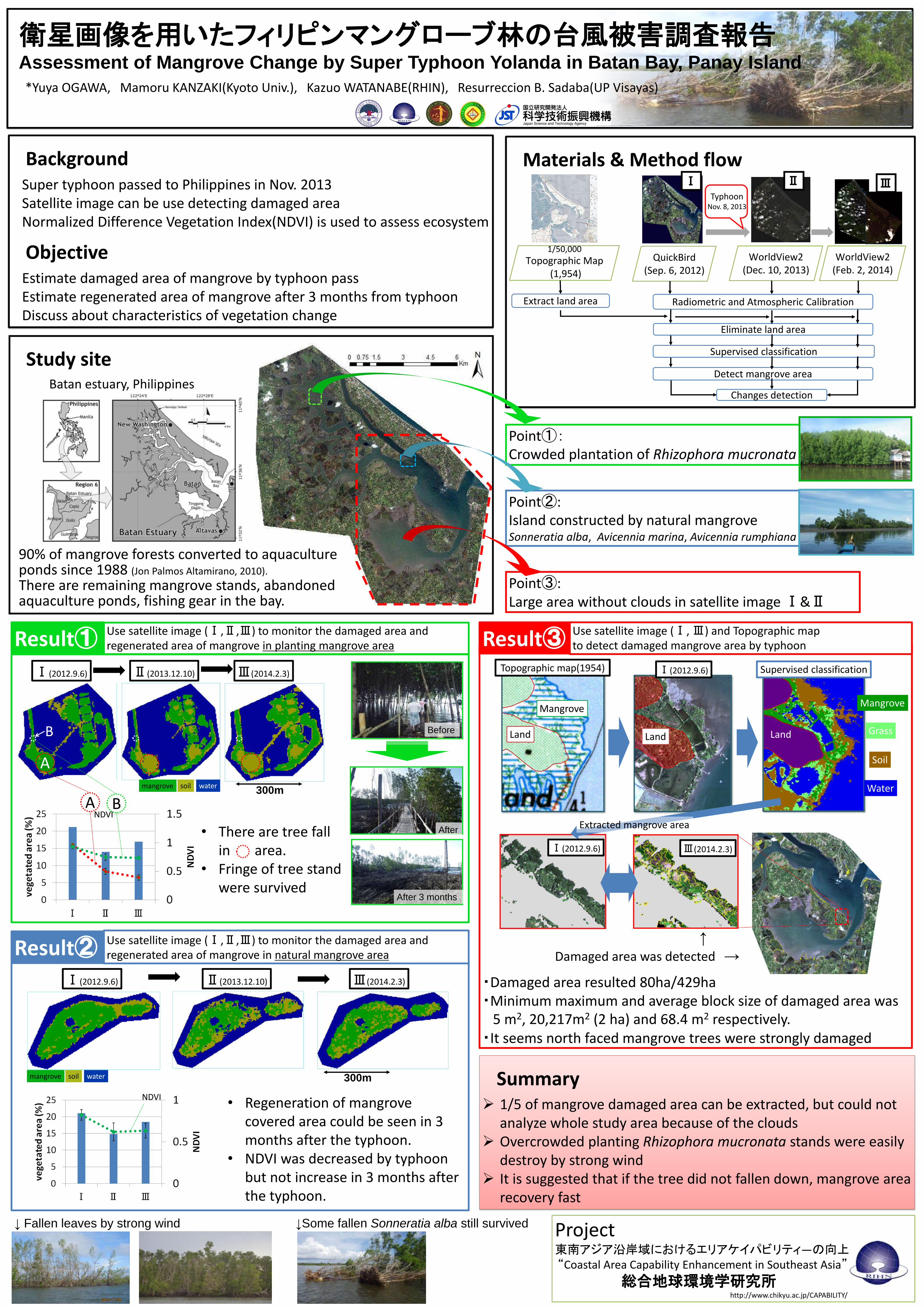
Materials & Method flow
Study siteBatan estuary, Philippines
Project東南アジア沿岸域におけるエリアケイパビリティ―の向上“Coastal Area Capability Enhancement in Southeast Asia”
総合地球環境学研究所http://www.chikyu.ac.jp/CAPABILITY/
BackgroundSuper typhoon passed to Philippines in Nov. 2013Satellite image can be use detecting damaged areaNormalized Difference Vegetation Index(NDVI) is used to assess ecosystem
ObjectiveEstimate damaged area of mangrove by typhoon passEstimate regenerated area of mangrove after 3 months from typhoonDiscuss about characteristics of vegetation change
Point①:Crowded plantation of Rhizophora mucronata
Point②:Island constructed by natural mangroveSonneratia alba, Avicennia marina, Avicennia rumphiana
↓Some fallen Sonneratia alba still survived↓ Fallen leaves by strong wind
・Damaged area resulted 80ha/429ha・Minimum maximum and average block size of damaged area was
5 m2, 20,217m2 (2 ha) and 68.4 m2 respectively.・It seems north faced mangrove trees were strongly damaged
Result③ Use satellite image (Ⅰ, Ⅲ) and Topographic mapto detect damaged mangrove area by typhoon
↑
Damaged area was detected →
Summary 1/5 of mangrove damaged area can be extracted, but could not
analyze whole study area because of the clouds Overcrowded planting Rhizophora mucronata stands were easily
destroy by strong wind It is suggested that if the tree did not fallen down, mangrove area
recovery fast
Mangrove
Land
Mangrove
Extracted mangrove area
Topographic map(1954) Ⅰ(2012.9.6)
Ⅲ(2014.2.3)Ⅰ(2012.9.6)
衛星画像を用いたフィリピンマングローブ林の台風被害調査報告Assessment of Mangrove Change by Super Typhoon Yolanda in Batan Bay, Panay Island
*Yuya OGAWA, Mamoru KANZAKI(Kyoto Univ.), Kazuo WATANABE(RHIN), Resurreccion B. Sadaba(UP Visayas)
Radiometric and Atmospheric Calibration
QuickBird(Sep. 6, 2012)
WorldView2(Feb. 2, 2014)
1/50,000
Topographic Map(1,954)
Extract land area
Changes detection
WorldView2(Dec. 10, 2013)
Ⅰ Ⅱ Ⅲ
90% of mangrove forests converted to aquaculture ponds since 1988 (Jon Palmos Altamirano, 2010).
There are remaining mangrove stands, abandoned aquaculture ponds, fishing gear in the bay.
Use satellite image (Ⅰ,Ⅱ,Ⅲ) to monitor the damaged area and regenerated area of mangrove in planting mangrove areaResult①
Ⅰ(2012.9.6) Ⅱ(2013.12.10) Ⅲ(2014.2.3)
• There are tree fall in area.
• Fringe of tree stand were survived
• Regeneration of mangrove covered area could be seen in 3 months after the typhoon.
• NDVI was decreased by typhoon but not increase in 3 months after the typhoon.
300m
300m
Use satellite image (Ⅰ,Ⅱ,Ⅲ) to monitor the damaged area andregenerated area of mangrove in natural mangrove areaResult②
Ⅰ(2012.9.6) Ⅱ(2013.12.10) Ⅲ(2014.2.3)
Point③:Large area without clouds in satellite image Ⅰ&Ⅱ
Land Land
300m
A
A
B
BNDVI
NDVI
mangrove soil water
mangrove soil water
Before
After 3 months
After
Eliminate land area
Supervised classification
Detect mangrove area
TyphoonNov. 8, 2013
Grass
Soil
Water
Supervised classification