coal combustion residual annual report
TRANSCRIPT

Coal Combustion Residual Annual Report
FirstEnergy Generation, LLC Little Blue Run Impoundment
Greene Township, Beaver County, Pennsylvania
January 2016
Prepared for: FirstEnergy Generation, LLC
800 Cabin Hill Drive Greensburg, Pennsylvania 15601
Prepared by: GAI Consultants, Inc.
Murrysville Office 4200 Triangle Lane
Export, Pennsylvania 15632-1358
Report Authors:
Maxwell J. Wallack Senior EIT
Kerry L. Frech, P.E. Civil Technical Leader

Coal Combustion Residual Annual Inspection Report FirstEnergy Generation, LLC Little Blue Run Impoundment
Page i
C910511.65, Task 005 / January 2016
Table of Contents
Certification/Statement of Professional Opinion ............................................................................... ii
1.0 Purpose .............................................................................................................................. 1
2.0 Introduction ........................................................................................................................ 1 2.1 Main Dam ................................................................................................................. 1 2.2 Saddle Dam .............................................................................................................. 2
3.0 Information Review ............................................................................................................. 2
4.0 Visual Inspection ................................................................................................................. 3 4.1 General Information .................................................................................................. 3 4.2 Inspection Strategy, Route, and Observations .............................................................. 3
4.2.1 Main Dam ..................................................................................................... 3 4.2.2 Saddle Dam .................................................................................................. 3
4.3 Geometry ................................................................................................................. 4 4.3.1 Main Dam ..................................................................................................... 4 4.3.2 Saddle Dam .................................................................................................. 4
4.4 Instrumentation ........................................................................................................ 4 4.4.1 Main Dam ..................................................................................................... 4 4.4.2 Saddle Dam .................................................................................................. 5
4.5 Depth and Elevation of Impounded Water and CCR ...................................................... 5 4.6 Storage Capacity ....................................................................................................... 5 4.7 Volume of Impounded Water and CCR ........................................................................ 5 4.8 Structural Appearance ............................................................................................... 5 4.9 Unit Performance ...................................................................................................... 6
5.0 Conclusions and Recommendations ....................................................................................... 6
6.0 References .......................................................................................................................... 7
Table 1 Approximate Depths and Elevations Appendix A Annual Inspection Checklist
© 2016 GAI Consultants, Inc.


Coal Combustion Residual Annual Report FirstEnergy Generation, LLC Little Blue Run Impoundment
Page 1
C910511.65, Task 005 / January 2016
1.0 Purpose Pursuant to the Federal Coal Combustion Residuals (CCR) Rule 40 CFR 257.83, each CCR unit is to have an annual inspection and report prepared by a qualified professional engineer. The inspection is to include:
A review of available information regarding the status and condition of the CCR unit, including, but not limited to, files in the operating record;
A visual inspection of the CCR unit to identify signs of distress or malfunction of the CCR unit; and
A visual inspection of any hydraulic structures underlying the base of the CCR unit or passing through the dike of the CCR unit for structural integrity and continued safe and reliable operation.
The inspection report is to include:
Any changes in geometry of the impounding structure since the previous annual inspection; The location and type of existing instrumentation and the maximum recorded readings of each
instrument since the previous annual inspection; The approximate minimum, maximum, and present depth and elevation of the impounded
water and CCR since the previous annual inspection; The storage capacity of the impounding structure at the time of the inspection; The approximate volume of the impounded water and CCR at the time of the inspection; Any appearances of an actual or potential structural weakness of the CCR unit, in addition to
any existing conditions that are disrupting or have the potential to disrupt the operation and safety of the CCR unit and appurtenant structures; and
Any other change(s) that may have affected the stability or operation of the impounding structure since the previous annual inspection.
2.0 Introduction The Little Blue Run impoundment (Impoundment) is located in Greene Township, Beaver County, Pennsylvania (PA). The Impoundment is on Little Blue Run, a tributary to Mill Creek and to the Ohio River. The Impoundment accepts CCR from the nearby FirstEnergy Bruce Mansfield Power Plant in Shippingport, PA. Solid wastes are pumped overland through a pipeline system approximately eight miles in length. Little Blue Run operates under National Pollutant Discharge Elimination System (NPDES) Impoundment Permit PA0027481. The Impoundment consists of two embankments, the main dam and the saddle dam.
Since 2004, coal combustion residuals have been deposited in the upper reaches of the impoundment behind a series of woven geotextile geotubes extending across the impoundment. This disposal is in accordance with the PA Department of Environmental Protection (PaDEP) Bureau of Waste Management (Solid Waste Permit No. 300558). The plan allows coal combustion solids to be stored to elevation 1162 National Geodetic Vertical Datum (NGVD) in the upper portion of the Impoundment. Disposal also occurs in the pool area adjacent to the main dam.
2.1 Main Dam The Little Blue Run Dam is permitted under PaDEP Dam Permit/I.D. No. D04-049. It is a zoned, earth and rockfill dam embankment with an impermeable clay core. Underlying the core, and also sloping with the core, is a two-part filter underdrain system that is connected to a blanket underdrain that underlies the entire dam embankment downstream of the clay core. A resistant rock protective shell exists on the upstream and downstream dam slopes, which are sloped at 2H:1V.

Coal Combustion Residual Annual Report FirstEnergy Generation, LLC Little Blue Run Impoundment
Page 2
C910511.65, Task 005 / January 2016
The dam is approximately 400 feet high with a crest elevation of 1,100 NGVD, a crest length of 2,100 feet, and a crest width of 50 feet. A roadway on the embankment crest provides access between the abutments. The normal operating pool elevation is 1,088 feet NGVD. The dam stores a maximum volume of 65,000 acre-feet. Approximately 1,694 acres are permitted for CCR disposal, of which approximately 1,000 acres are used.
Near the downstream toe of the dam, two perforated, one-foot-diameter, poly vinyl chloride (PVC) drain pipes, embedded within the foundation filter underdrain system, extend along the toe of the embankment to both abutments. Both pipes drain the foundation blanket underdrain by gravity to a concrete sump located at the toe of the dam. The sump drains into a solid 16-inch outside diameter (O.D.) PVC toe drain (TD) pipe extending approximately 290 feet, then discharges into the Stilling Basin. The 16-inch PVC TD pipe is embedded at the bottom and along the center line of an approximately 290-foot-long, redundant, trapezoidal, two-part filter system with an average cross-sectional width of 32 feet and nominal height of 12 feet. The redundant, trapezoidal filter is designed to carry flow in excess of the design flow from the dam embankment underdrain system in the event of a TD pipe failure. Water has never been observed in the redundant, trapezoidal filter system. The 16-inch O.D. PVC TD pipe discharges into a Parshall Flume TD, which discharges directly into the Stilling Basin.
2.2 Saddle Dam An additional embankment, the Little Blue Run Saddle Dam, was constructed approximately 2,200 feet upstream of the main dam on the east side of the Little Blue Run valley. The embankment is permitted under PaDEP Dam Permit/I.D. No. D04-068. The dam is 13 feet in height and constructed with an internal clay core and downstream embankment toe drainage system. The Saddle Dam fills a low area in the ridge line between the Little Blue Run and Mill Creek valleys. No spillways are located at the Saddle Dam.
3.0 Information Review CCR Rule §257.83(b)(1)(i) states that an inspection includes, “a review of available information regarding the status and condition of the CCR unit, including, but not limited to, files available in the operating record (e.g., CCR unit design and construction information required by §257.73(c)(1) and §257.74(c)(1), previous periodic structural stability assessments required under §257.73(d) and §257.74(d), the results of inspections by a qualified person, and results of previous annual inspections).”
GAI reviewed the following available information:
Daily Inspection Reports; 2014 Annual Inspection and Evaluation Report; 2015 Pre-Inspection findings; Site record drawings; and Permit documents.
The reports are listed under the References section. Conversations were held with the Environmental Field Operations personnel before the inspection to obtain additional information such as operation and maintenance procedures, current state of the landfill, and the typical process for the operators’ daily reports.
The surface monument surveys were performed by Michael Baker, Jr., Inc. (Baker) on May 7, 2015 and October 30, 2015.

Coal Combustion Residual Annual Report FirstEnergy Generation, LLC Little Blue Run Impoundment
Page 3
C910511.65, Task 005 / January 2016
4.0 Visual Inspection 4.1 General Information The inspection was performed on Tuesday, October 20, 2015. Mr. Ray D. Glenn, P.G., and Mr. Kerry L. Frech, P.E., of GAI performed the inspection. The weather was breezy and partly cloudy, with temperatures in the 60s (Fahrenheit). Minimal rain occurred in the two days prior to the inspection.
4.2 Inspection Strategy, Route, and Observations The GAI team inspected the impoundment and its facilities by making visual observations, recording site conditions, and talking to plant personnel.
4.2.1 Main Dam
The inspection started at the left abutment of the embankment, and included observations of surficial soil slides on the left abutment, and recording water levels in the left abutment piezometers (LA-01 through LA-07B). Comparison of the recorded levels with historic levels indicated that the recorded levels were within the range of historic levels. The personnel then viewed the service and emergency spillways and approach channel conditions on the left abutment.
The crest and the upstream and downstream faces, and conditions within the impoundment were then observed in crossing the dam along the crest to the right abutment. Water levels in the crest piezometers (EMB-1 and EMB-2) were also recorded. These piezometers were found to be dry, consistent with past results. At the right abutment, the personnel inspected the secondary spillway and approach channel.
On the right abutment, the splitter box and the main discharge channel of the secondary spillway were observed. The secondary spillway was not in operation at the time of the inspection. Seepage conditions on the right abutment were observed at the right abutment bench, including a reading at the Right Abutment Flume (RA Flume). The reading was consistent with past readings. Observations of the left abutment and the downstream dam face were made in traversing the access road below the right abutment.
The “North-South” line, which denotes the boundary where disposal may occur above elevation 1088.0 feet NVGD in accordance with Solid Waste Permit No. 300558, was observed from the eastern side to assess disposal activities in compliance with the facility’s permitted operations plan. Additional observations of conditions within the impoundment were made from the eastern side.
The embankment toe and downstream area were then observed. Conditions at the Toe Drain flume, the Stilling Basin, the Main Discharge Channel, the Service Spillway outlet, and the instrumentation facilities were observed. Readings were taken at the RA Weir, the RA Flume 2, the Upper Left Abutment (ULA) Weir, the Toe Drain, the Stilling Basin, and the Lower Left Abutment (LLA) Weir. All readings were consistent with past values.
The outlet of Little Blue Run at Mill Creek, and the outlet of the By-pass Pipe Discharge to the Ohio River, were observed to conclude the main dam inspection.
4.2.2 Saddle Dam
Conditions at the Saddle Dam were observed, and water levels in SD-1 and SD-3 were recorded, with levels consistent with past levels. No seepage was observed from the Saddle Dam embankment toe.

Coal Combustion Residual Annual Report FirstEnergy Generation, LLC Little Blue Run Impoundment
Page 4
C910511.65, Task 005 / January 2016
4.3 Geometry Pursuant to §257.83(b)(2)(i), “any changes in the geometry of the impounding structure since the previous annual inspection” are reported. The current cumulative movements of the monuments at the dam over the life of the dam (1976 to present) are presented in Table 2. These movements recorded by survey are considered within the range of movements that can be expected of an embankment dam of this size.
4.3.1 Main Dam
The crest and the upstream and downstream slopes of the Little Blue Run Dam embankment were examined, and no cracking, slumping, or burrow holes were observed. No visual signs of slope instability were observed. The crest had no visual indication of lateral or vertical movement. Based on visual inspection and a comparison to the design drawings, no changes to the geometry of the impoundment were observed. Assessment of the monument survey performed by Baker did not indicate movements out of line with past movements.
4.3.2 Saddle Dam
The crest and the upstream and downstream slopes of the Saddle Dam embankment were examined, and no cracking, slumping, or large burrow holes were observed. One small burrow hole was observed on the downstream face near the crest of the Saddle Dam, which has been reported to have since been filled. No visual signs of slope instability were observed. The crest had no visual indication of lateral or vertical movement. Based on visual inspection and a comparison to the design drawings, no changes to the geometry of the impoundment were observed.
4.4 Instrumentation Pursuant to CFR §257.83(b)(2)(ii), “the location and type of existing instrumentation and the maximum recorded readings of each instrument since the previous annual inspection” are reported. Because this is the first annual inspection, under CCR rule §257.83, the recorded readings were reviewed for the past year, but are not reported here.
4.4.1 Main Dam
FirstEnergy personnel take readings of the RA-Flume, RA-Weir, ULA Weir, LLA Weir, the TD, and at the Stilling Basin on a daily basis. Readings are taken of the piezometers twice yearly by GAI personnel. The data is evaluated on a water year basis, from October 1 of a given year through September 30 of the following year. The RA-Flume and the RA-Weir monitor seepage at the right abutment. The RA-Weir also receives storm runoff flows, and flows through the secondary spillway; therefore, data for days in which significant rainfall occurs (greater than 0.5-inch), or when the secondary spillway is operating, are excluded from the assessment of seepage. The ULA and LLA Weirs also receive both seepage and storm runoff flows. Data for days in which significant rainfall (greater than 0.5-inch) has occurred are also excluded from the seepage assessment for these weirs, and also for the Stilling Basin. Twelve open-tube well points have been installed on the Little Blue Run Dam and its environs. Two open-tube piezometers (UD-1, UD-2) monitor the water elevation in the embankment filter blanket/underdrain system near the downstream toe of the embankment. Two open-tube well points (EMB-1, EMB-2) are situated on the crest of the dam embankment, to monitor potential development of a phreatic surface within the embankment should such a surface develop. EMB-1 and EMB-2 have been dry since their installation in 2010. Eight open-tube well points (LA-01, -02, -03, -04, -05, -06, -07a, -07b) are situated on the downstream left abutment. Three of these well points (LA-01, LA-02, and LA-03) are located on the ridge line between the dam and the Emergency Spillway, and the remaining five are on the slope between the dam and the Service Spillway right-of-way. The data for the piezometers was last reviewed in October 2015.

Coal Combustion Residual Annual Report FirstEnergy Generation, LLC Little Blue Run Impoundment
Page 5
C910511.65, Task 005 / January 2016
Twenty-two surface monuments have been installed on Little Blue Run Dam, and are monitored for vertical and horizontal movement. Nine monuments are located on the crest, and 13 are located on the downstream face of the dam. The most recent readings, obtained in October 2015, indicate movements consistent with past surveyed movements, and within the range of movements that can be expected of an embankment dam of this size.
4.4.2 Saddle Dam
Two well points have been installed in the Little Blue Run Saddle Dam, at the crest (SD-1), and near the downstream toe (SD-3). The data for the piezometers was last reviewed in October 2015. SD-3 has been dry since installation in late 2014. The water level measured in SD-1 is below the water level that would affect the stability of the embankment.
4.5 Depth and Elevation of Impounded Water and CCR Pursuant to CFR §257.83(b)(2)(iii), “the approximate minimum, maximum, and present depth and elevation of the impounded water and CCR since the previous annual inspection” are reported.
The approximate depths and elevations of the impounded water and CCR at the time of inspection, October 20 2015, are listed below in Table 1.
Table 1. Approximate Depths and Elevations.
Depth (feet)1 Elevation (NVGD)
Min. Max. Present Min. Max. Present
340.2 342.2 341.73 1087.2 1089.2 1088.73 1 The impoundment depths are based on a minimum impoundment bottom elevation of 747 feet NVGD (Drawing GN-2375-S-28).
4.6 Storage Capacity Pursuant to CFR §257.83(b)(2)(iv), “the storage capacity of the impounding structure at the time of the inspection” is reported.
The approximate total storage capacity of the Impoundment is 104,900,000 cubic yards (65,000 acre-feet).
4.7 Volume of Impounded Water and CCR Pursuant to CFR §257.83(b)(2)(v), “the approximate volume of the impounded water and CCR at the time of the inspection” is reported.
The approximate volume of the impounded CCR and water in the Impoundment at the time of the inspection was 95,300,000 cubic yards.
4.8 Structural Appearance Pursuant to CFR §257.83(b)(2)(vi), “any appearances of an actual or potential structural weakness of the CCR unit, in addition to any existing conditions that are disrupting or have the potential to disrupt the operation and safety of the CCR unit and appurtenant structures” are reported.
Based on visual inspection, the impoundments appeared to have no structural weaknesses, and no existing conditions were observed that are disrupting or that have the potential to disrupt the operation and safety of the CCR unit at the time of inspection. The seepage flows monitored at the weirs and flumes are consistent with past flows, and do not pose a risk to structural stability.

Coal Combustion Residual Annual Report FirstEnergy Generation, LLC Little Blue Run Impoundment
Page 6
C910511.65, Task 005 / January 2016
4.9 Unit Performance Pursuant to CFR §257.83(b)(2)(vii), “any other change(s) which may have affected the stability or operation of the impounding structure since the previous annual inspection” are reported.
Based on a visual inspection, no other changes were observed that would affect the stability or operation of the landfill beyond what was mentioned in the Inspection Strategy, Route, and Observations section.
5.0 Conclusions and Recommendations During the 2015 visual inspection of the impoundment, GAI did not find signs of distress or malfunction that would affect the structural condition of the impoundment. No releases of CCR were observed during the 2015 inspection. Animal burrows are maintenance issues that will be addressed by the landfill operator, Bruce Mansfield Plant.

Coal Combustion Residual Annual Report FirstEnergy Generation, LLC Little Blue Run Impoundment
Page 7
C910511.65, Task 005 / January 2016
6.0 References Environmental Protection Agency, 40 CFR Parts 257 and 261, Hazardous and Solid Waste Management
System; Disposal of Coal Combustion Residuals from Electric Utilities, April 17, 2015.
FirstEnergy Corporation, Bruce Mansfield Plant, Daily Dam Inspection: Little Blue Run Dam, October 1, 2014 — September 30, 2015.
GAI Consultants, Inc., Plot Plan Impoundment, Drawing No. E-8399- (GH No. 2375-S-23), February 15, 1974.
GAI Consultants, Inc., Inspection and Evaluation Report No. 101, December 2015.
Pre-Inspection Site Memo, July 22, 2015 Site Visit, GAI Consultants, Inc., September 2, 2015.

Coal Combustion Residual Annual Report FirstEnergy Generation, LLC Little Blue Run Impoundment
C910511.65, Task 005 / January 2016
APPENDIX A Annual Inspection Checklist
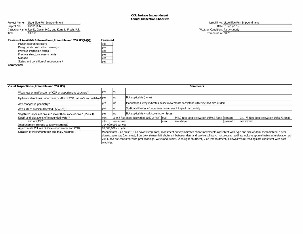
Project Name Little Blue Run Impoundment Landfill No. Little Blue Run Impoundment
Project No. C910511.65 Date 10/20/2015
Inspector Name Ray D. Glenn, P.G., and Kerry L. Frech, P.E. Weather Conditions Partly cloudy
Time 10 a.m. Temperature 60 °F
Review of Available Information (Preamble and 257.83(b)(i)) Reviewed
Files in operating record yes
Design and construction drawings yes
Previous inspection forms yes
Previous structural assessments yes
Signage yes
Status and condition of impoundment yes
Comments:
Visual Inspections (Preamble and 257.83)
Weakness or malfunction of CCR or appurtenant structure? yes no
Hydraulic structures under base or dike of CCR unit safe and reliable? yes no Not applicable (none)
Any changes in geometry? yes no Monument survey indicates minor movements consistent with type and size of dam
Any surface erosion detected? (257.73) yes no Surficial slides in left abutment area do not impact dam safety
Vegetated slopes of dikes 6" lower than slope of dike? (257.73) yes no Not applicable - rock covering on faces
Depth and elevations of impounded water? min 340.2 feet deep (elevation 1087.2 feet) max 342.2 feet deep (elevation 1089.2 feet) present 341.73 feet deep (elevation 1088.73 feet)
and of CCR? min see above max see above present see above
Impoundment storage capacity (current)? 104,900,000 cu. yds
Approximate Volume of impounded water and CCR? 95,300,000 cu. yds
Location of instrumentation and max. reading?
CCR Surface Impoundment
Annual Inspection Checklist
Comments
Monuments: 9 on crest, 13 on downstream face; monument survey indicates minor movements consistent with type and size of dam. Piezometers: 2 near
downstream toe, 2 on crest, 8 on downstream left abutment between dam and service spillway; most recent readings indicate approximate same elevation as
2014, and are consistent with past readings. Weirs and flumes: 2 on right abutment, 2 on left abutment, 1 downstream; readings are consistent with past
readings.