coastal geomorphic conditions and styles of storm surge ... · coastal geomorphic conditions and...
TRANSCRIPT

Geomorphology 192 (2013) 43–58
Contents lists available at SciVerse ScienceDirect
Geomorphology
j ourna l homepage: www.e lsev ie r .com/ locate /geomorph
Coastal geomorphic conditions and styles of storm surge washover deposits fromSouthern Thailand
Sumet Phantuwongraj a, Montri Choowong a,⁎, Futoshi Nanayama b, Ken-Ichiro Hisada c, Punya Charusiri a,d,Vichai Chutakositkanon a, Santi Pailoplee a,d, Akkaneewut Chabangbon a,e
a Department of Geology, Faculty of Science, Chulalongkorn University, Bangkok 10330, Thailandb Geological Survey of Japan, AIST, Tsukuba, Ibaraki 305-8567, Japanc Graduate School of Life and Environmental Sciences, University of Tsukuba, Ibaraki 305-8572, Japand Earthquake and Tectonic Geology Research Unit (EATGRU),Chulalongkorn University, Bangkok 10330, Thailande Department of Geological Sciences, Stockholm University, Stockholm 10691, Sweden
⁎ Corresponding author. Tel.: +66 2 218 5445; fax: +E-mail address: [email protected] (M. Choowo
0169-555X/$ – see front matter © 2013 Elsevier B.V. Alhttp://dx.doi.org/10.1016/j.geomorph.2013.03.016
a b s t r a c t
a r t i c l e i n f oArticle history:Received 24 May 2012Received in revised form 28 February 2013Accepted 10 March 2013Available online 22 March 2013
Keywords:Washover sedimentStorm surgeOverwash processesNortheast monsoonSouthern Thailand
The characteristics of tropical storm washover deposits laid down during the years 2007 to 2011 along thesouthern peninsular coast of the Gulf of Thailand (GOT) were described in relation to their different geomor-phic conditions, including perched fan, washover terrace and sheetwash lineations preserved behind thebeach zone within 100 m of the shoreline. As a result, washover terrace and sheetwash lineations werefound where the beach configuration was uniform and promoted an unconfined flow. Non-uniform beachconfigurations that promoted a confined flow resulted in a perched fan deposit. Washover sediments weredifferentiated into two types based on sedimentary characteristics, including (i) a thick-bedded sand of mul-tiple reverse grading layers and (ii) a medium-bedded sand of multiple normal grading layers. In the case ofthick-bedded washover deposits, the internal sedimentary structures were characterized by the presence ofsub-horizontal bedding, reverse grading, lamination, foreset bedding and wavy bedding, whereas, horizontalbedding, normal grading, and dunes were the dominant structures in the medium-bedded washover sand.Rip-up clasts were rare and recognized only in the washover deposits in the bottom unit, which reflectsthe condition when a mud supply was available. All washover successions were found in the landwardinclined-bedding with a basal sharp contact. A high elevated beach ridge associated with a large swale atthe backshore proved suitable for a thick-bedded washover type, whereas a small beach ridge with uniformlyflat backshore topography promoted a medium-bedded washover sediment.
© 2013 Elsevier B.V. All rights reserved.
1. Introduction
Washover deposits are one of the significant results of high energyseawater flooding across a beach or dune. They can be generated fromsuch high intensity processes as tsunamis and storms. In the past de-cades, rapid flooding from tsunami and coastal storms have beenamong the main coastal hazards and have caused damage to coastalcommunities and infrastructure, e.g. 1960 Chilean tsunami, 1989 Ty-phoon Gay in Thailand, 2004 Sumatra tsunami, 2005 HurricaneKatrina in USA, 2008 Cyclone Nargis in Myanmar, 2009 TyphoonMorakot in China and Taiwan, 2011 Great East Japan tsunami, and2011 Hurricane Irene in USA. These high energy flows usually bringthe sediments from the seaward side, especially from nearshore tobeach, to be deposited on the landward side beyond the beach zone.
In fact, the sedimentary characteristics and physical properties ofstorm-induced washover deposits have been published since the
66 2 218 5464.ng).
l rights reserved.
1960s. The first observable features of storm incidence are changesin beach morphology, which has led to the subsequent study of thechanges in the coastal morphology after storm events (Hayes, 1967;Wright et al., 1970; Schwartz, 1975; Morton, 1976; Kahn andRoberts, 1982; Morton and Paine, 1985; Thieler and Young, 1991;Wang et al., 2006; Claudino-Sales et al., 2008). Along these lines,Schwartz (1975) presented the common stratigraphy of stormwashover deposits as a horizontal stratification of laminated sandwhich usually shows foreset laminae in its distal part if it penetratesinto a pond or lagoon. Morton and Sallenger (2003) classified thechanges in the coastal landform features after storm events into twotypes, (i) the erosional features (dune erosion, channel incision, andwashout) and (ii) the depositional features (perched fan, washoverterrace, and sheetwash lineations), based on their formation process-es. Since then, these features are often applied as the key criteria toassist in the identification of the intensity and flow conditions ofeach storm event. Sedgwick and Davis (2003) also reported the fivesubfacies in storm deposits that represent the differences in flow con-ditions during overwash, the position relative to sea level, and

44 S. Phantuwongraj et al. / Geomorphology 192 (2013) 43–58
variable degrees of reworking after deposition. Wang and Horwitz(2007) reported the different erosional and depositional characteris-tics of washover sediments induced by hurricanes from severalbarrier-island sub-environments, including dune field, interior wet-land and back-barrier bay. They proposed that the different erosionaland depositional characteristics are caused by the different overallbarrier-island morphologies, vegetation types and densities, and sed-iment properties.
Within the literature, the sedimentary characteristics and bedformsurfaces of storm deposits that have been characterized have includednormal grading (Andrews, 1970; Sedgwick and Davis, 2003; Mortonet al., 2007; Wang and Horwitz, 2007; Phantuwongraj et al., 2008;Spiske and Jaffe, 2009), reverse grading (Leatherman and Williams,1983; Sedgwick and Davis, 2003; Morton et al., 2007; Wang andHorwitz, 2007; Phantuwongraj et al., 2008; Spiske and Jaffe, 2009), lam-inae/laminaset (Leatherman and Williams, 1977; Sedgwick and Davis,2003; Morton et al., 2007; Wang and Horwitz, 2007), sub-horizontalbedding (Deery and Howard, 1977; Schwartz, 1982; Phantuwongrajet al., 2008), foreset bedding/laminae (Schwartz, 1975; Deery andHoward, 1977; Schwartz, 1982; Davis et al., 1989; Nanayama et al.,2000; Morton et al., 2007; Wang and Horwitz, 2007), antidune(Schwartz, 1982), rhomboid bedform (Morton, 1978 and Schwartz,1982) and current ripples (Deery and Howard, 1977; Schwartz, 1982;Morton et al., 2007; Komatsubara et al., 2008). However, mostof these sedimentary features are also found in tsunami deposits(e.g., Gelfenbaum and Jaffe, 2003; Choowong et al., 2007; Morton etal., 2007; Choowong et al., 2008a,b; Jankaew et al., 2008; Shanmugam,2012). Thus, it is sometimes challenging to distinguish whether sandsheets in the geological records were originally formed as the result ofa tsunami or a storm. This challenge has led many geologists and sedi-mentologists to develop the key criteria for distinguishing tsunamifrom storm deposits (Nanayama et al., 2000; Goff et al., 2004; Tuttleet al., 2004; Kortekaas and Dawson, 2007; Morton et al., 2007;Komatsubara et al., 2008; Switzer and Jones, 2008a; Phantuwongrajand Choowong, 2012). However, the identifiable features, such as thesedimentary characteristics, washover geometry and biological evi-dence, that are used in the differentiation of these two types of high en-ergy flows are still equivocal because their deposition often depends onthe topographical control, local source of sediments and the intensity ofthe event, and these factors usually differ from place-to-place.
The coast of Thailand has also been attacked by storm surgeswhich cause damage to coastal communities. Although, Thailand hasexperienced storm surges at least three times recently from tropicalstorms (“Harriet” in 1962, typhoon “Gay” in 1989 and typhoon“Linda” in 1997), only a few reports on the storm deposits havebeen published (e.g. Roy, 1990). Phantuwongraj et al. (2008), subse-quently, reported the possible storm deposits found along the coast atSurat Thani and Nakhon Si Thammarat on the Gulf of Thailand (GOT).The discovery in tracing the storm deposits was extended northwardsalong this coastline to Chumphon where Phantuwongraj et al. (2010)found multiple layers of paleo-storm sand sheets in a swale located1 km inland and far away from the present shoreline. However,more detailed studies of the sedimentary characteristics, topographi-cal and flow conditions of the washover deposits induced by stormsare still required, particularly for Thailand where so little is known.
Here, in this paper, the sedimentary characteristics of stormwashover deposits from different geomorphic conditions associatedwith the storm events during the period 2007–2011 in Thailand aredescribed systematically. We start from the identification of the dis-tinctive sedimentary features of washover deposits from the threedifferent geomorphic settings preserved along the GOT coast. Com-parison of the topographical and flow conditions from the individualand geological settings related to washover sediment features is alsomade. This study presents the first detail of recent storm depositsfrom the Southeast Asia region which also can be used as a modernanalog for storm deposits from other areas. The similarity and
differences in the sedimentary features found in storm depositsfrom different geological settings may help geoscientists to under-stand further what (and how) storms leave behind as their evidencein the geological record.
2. Setting and method
The climate of Thailand is under the influence of twomainmonsoonwinds that are seasonal in character, being the southwest (SW) mon-soon and NE monsoon. The SW monsoon in May–October brings astream of warmmoist air from the Indian Ocean towards the Thai Pen-insula, resulting in an abundance of rain over the country. Subsequently,the NE monsoon in October–February, originally forming as cold anddry air, is driven frommainland China towards Thailand. This graduallycauses the cold condition in the winter season, especially in the north-ern and NE highlands, whereas in the southern part of Thailand thisNE monsoon normally causes a mild weather and heavy rain alongthe eastern (GOT) coast of the Thai Peninsula. During the NE monsoonseason, sea level in the GOT is normally raised higher than mean sealevel (MSL) (Fig. 1) due to seawater from South China Sea movingdownward and then flowing into the GOT corresponding to the prevail-ing wind from the NE direction. In contrast, in SWmonsoon season, theprevailing wind blows to the opposite side which leads to seawatermoving out of the GOT, thus sea level in the GOT is lower than the aver-age MSL. The average change of sea level in the GOT caused by thechange in monsoonal wind is 0.4 m. Additionally, during November–December, the eastern side of southern Thai Peninsula is usually affect-ed by depressions or tropical storms and sometimes typhoons from theeastern side of GOT, which can generate storm surges and causeoverwash flow in the low-lying coastal area. However, Thailand has ex-perienced storm surges induced by tropical stormor typhoon only threetimes since the 1960s. Apart from the storm events, the temporary in-crease in monsoonal wind velocity above its usual speed for a few suc-cessive days during NEmonsoon season also causes a storm surge up to1.25–2.5 m high in the low-lying coastal area along the Southern Thai-land coast (Fig. 1). According to the frequency of their occurrence, atleast once a year, washover deposits resulting from temporary strongNE winds are found to be more in number than the washover depositsinduced by tropical storms or typhoons. This phenomenon of stormsurge being induced by temporary strong NEwinds usually occurs dur-ing November to January as it is the period of highest sea level duringthe year. A storm surge induced by strong winds during the NE mon-soon season is also found in Singapore (Tkalich et al., 2012).
We focused on three sites (Fig. 2a), (1) Ban Takrop (BT) in SuratThani (Fig. 2c), (2) Laem Talumphuk (LT) in Nakhon Si Thammarat(Fig. 2d), and (3) Khao Mai Ruak (MR) in Prachuap Khiri Khan(Fig. 2b), that were effected by storm surges during the period2007–2011. Five storm surge events during this time were inducedby (i) seasonal sea-level rise accompanied with temporary strongNE winds over 2007 to 2010 and (ii) a low-pressure system in 2011.The maximum wind speed measured from three weather stationsclosest to each study site was 20–22 knots. The potential heights ofstorm tide were at 2.30–2.96 m above MSL, as calculated from tidegauge data and significant wave height data at each study site(Fig. 3). Storm surges caused erosion to the beach and also expandedthe inlet/outlet channels. The damage also extended to a road andhouse along the shoreline.
At the study sites, we investigated the damage and particularlyaimed to record how the beachmorphology had changed. The evidenceof erosion and deposition features along the coastal area resulting fromstorm surges weremeasured and photographed. Trenching, coring, andpitting were made for examination of the washover sediment charac-teristics. The washover sediments were sampling systematically layerby layer from top to bottom. A detailed coastal topographical profile,using a digital survey camera, was performed. Grain size analysis was

Fig. 1. (a) Average monthly sea-level change in the Gulf of Thailand (GOT) from 1940 to 2007. (b) Average monthly wind speed and direction from 1971 to 2000 from the nearestweather stations to the three study sites. (c) Map demonstrates usual NE and SWmonsoon directions in Thailand and location of tide gauge stations and weather stations. Bold linebounds the areas commonly affected by overwash flow by storm surges.
45S. Phantuwongraj et al. / Geomorphology 192 (2013) 43–58
carried out at the Geological Survey of Japan using a Camsizer. Sedimentcompositions were identified under a binocular microscope.
In this study, the classification of the type of washover deposits interms of “perched fan”, “washover terrace” and “sheetwash” wasbased on the work of Morton and Sallenger (2003) who described aperched fan as a small lobate to elongate washover feature that is ori-ented perpendicular to the shore. A washover terrace is then charac-terized as an elongate washover deposit that is oriented parallel tothe shore. The washover terrace may form a uniformly wide band,or its landward margins may be highly irregular depending on the in-teractions between breaking waves and currents during washoverdeposition. Lastly, sheetwash usually shows narrow elongate zonesof erosion and deposition that form lineations parallel to the directionof flow. The flood regime, including the overwash regime and inunda-tion regime, followed the conceptual model of storm impact regimeoriginally proposed by Sallenger (2000). Terminology used for differ-entiating the thickness of beds and laminae followed that of Campbell(1967).
3. Results
3.1. 2007–2008 storm deposits at Ban Takrop (BT), Surat Thani
At BT, the area displays as prograded shoreline which is composedof relict strand lines oriented in the northwest–southeast direction(Fig. 2c). Between the relict strand lines, the topography exhibits aswale which is about 10–15 m wide in the south and then narrowstowards the north with an average width of 3–4 m. The outer beachridge is 2 m high above mean sea level (MSL) and yields a slightlysteep slope (8°) at the foreshore. The average tidal range here is1.09 m while the maximum range during spring tide time can be upto 2.07 m. We visited BT in July 2008 after an overwash event onthe 25th April 2008, to investigate the change in beach morphology.The storm tide high at least 2.96 m above MSL was calculated from
Lang Suan tide gauge station and significant wave height data(Fig. 3). The maximum inundation distance of the 25th April 2008storm surge was 100–300 m from the shoreline. The morphology ofthe wide swale between the relict strand lines also limited theflooding zone from overwash flow in this area.
The washover deposit found at BT exhibited as a narrow band ofsand that was oriented parallel to the shore. Based on its morphology,washover deposition here was classified as washover terrace type fol-lowing Morton and Sallenger (2003). The washover terrace is 30 m inwidth perpendicular to the shore and 600 m in length parallel to theshoreline (Fig. 4a). At the distal part in landward side, the washover de-posit was spilt as a series of fan lobes into a swale behind the beach.More than ten lobeswere observed and each of thesewas approximate-ly 10 m in width orientating parallel to shoreline (Fig. 4b). The thick-ness of the washover sediment reaches a maximum of 80 cm in theproximal part and terminates with a steeply avalanche face into theswale (Fig. 5a). Some parts of washover sediment also penetrate intothe Nipa palm habitat zone, as observed from the sand body the burieda palm tree (Fig. 5c). The bottom contact between washover sedimentand mud in the swale shows as a sharp contact that indicates a suddendepositional process. Garbage possibly came along with the overwashflow also found within the washover sediment (Fig. 5d).
The washover deposit exhibited a bedding plane dipping in a land-ward direction, with eleven layers of coarse to very coarse-grainedsand andmultiple laminae of medium to coarse-grained sandwere rec-ognized (Fig. 5b). Each layer showed reverse grading (Fig. 5e) whichconsists of medium grained sand laminae 0.7–1 cm thick at the baseand then changing to coarse to very coarse-grained sand upwards tothe top, with a thickness varying from 2 to 7 cm (Fig. 5b, e). Thewashover deposit here can be divided into two units based on its differ-ence in lithology, including the thickness and inclination of layers(Figs. 5b and 6c). The thickness of washover sand layers at the lowerunit ranges from 2 to 6 cm and displays a low dip angle being almosthorizontal to sub-horizontal bedding. In contrast, the thickness of

Fig. 2. Geomorphological map of the study sites. (a) The three sites along the GOT, with the geomorphic setting map at (b) Khao Mai Ruak (MR), Prachuap Khiri Khan, (c) BanTakrop (BT), Surat Thani and (d) Laem Talumphuk (LT), Nakhon Si Thammarat. Also shown are the locations of subsequent figures.
46 S. Phantuwongraj et al. / Geomorphology 192 (2013) 43–58
washover layers in the upper unit was thicker, at about 4–7 cm, and theinclination of layers was also much steeper than the lower unit. Theforeset bedding was inclined 22° and 35° in the upper unit, and wasalso observed at the washover margin (Figs. 5b and 6c).
Sediment samples were collected layer by layer from top to bottom.Nineteen sampleswere collected fromwashover sediment (layers 10 to1) and sub-surface sediment (Fig. 6). According to the grain size analy-sis, the grain size distribution in the coarse to very coarse sand layer andthe medium sand laminae shows unimodal and bimodal distributionwhereas the sub-surface sediment shows only a unimodal distribution(Fig. 6a). In the medium sand laminae, there are three samples thatshowbimodal distribution (numbers 2, 5, and 12)which are clearly rec-ognized as two peaks ofmedium sand and coarse sand. These two peaksof sediment size in the medium sand laminae may result from the con-tamination of the layer beneath during the sampling as coarse sand atthe top of layer 9 is mixed during sampling of the base of layer 10.From the grain size distribution graph, the medium sand laminaeshows an asymmetrical distribution with a negative skewness value,whereas the coarse to very coarse sand layer shows both symmetrical(1, 13, and 14) and asymmetrical distributions (3, 4, 6, 9, 11, 16, and17)with positive skewness. However, sample 7 shows a negative skew-ness similar to sample 8 that is from amedium sand laminae. The aver-age grain size of samples 7 and 8 are also close at 0.5 and 0.62 phi,respectively. Based on the lithology, the upper part of layer 6, indicatedas a boundary layer between unit 1 and unit 2, as exhibited in the
unusual grain size distribution and grain size value of sample 7, mayhave resulted from the aeolian process after the storm event. Thisreworked surface is similar to washover sediments found in Australiathat are characterized by two storm layers separated by a thin veneerof sand that has been reworked by aeolian processes (Switzer andJones, 2008b).
According to the poor compaction of washover sand, the freshcondition of garbage in the washover sediment, and a burial of aNipa palm that is still alive, the lower unit of this washover depositshould be the result of a recent storm surge event that occurred with-in one year. From the tide gauge data from a station near the BT area,on the 29th November 2007, the potential storm tide with a height of2.56 m generated overwash flow across beach and flooded into swale.Therefore, the 1st unit should be the result of the storm surge eventon 29th November 2007 that is the only storm surge over the periodOctober 2007 to April 2008. The reworked surface (i.e. sample 7) maythen result from aeolian processes induced by high velocity NE windsduring December to February.
The sedimentary structures in the washover deposits includedlamination, foreset bedding, wavy bedding and reverse grading(Fig. 5b, d). At the proximal part, horizontal bedding is the dominantstructure, whereas foreset bedding was principally found in the distalpart of the washover deposits. The grain composition includes quartz,shell fragments, feldspar and rock fragments. Washover sand grainsare moderately well to moderately sorted.

Fig. 3. Records of tide during storm surge from 2007 to 2011 in the study sites from the nearby tide gauge stations (left). Significant wave height and wave direction map in theSouth China Sea and the GOT during the 2008–2011 overwash events (middle). Location of tide gauge stations and the study sites (right). Recorded tide and predicted data;from Hydrographic Department, Royal Thai Navy. Significant wave height and wave direction data are from Oceanweather, Inc. and www.thaiwater.net.
47S. Phantuwongraj et al. / Geomorphology 192 (2013) 43–58
3.2. 2009 storm deposits at Laem Talumphuk (LT), Nakhon Si Thammarat
LT is an active sand spit, 6 km long and 500–700 m wide with asouth–north trending orientation that corresponds to the majorpresent-day longshore current. The spit itself developed an east–west orientation of a series of former beach ridges. The distal part ofthe spit recurves to the west (Fig. 2d). The spit recently consists of a
relatively small modern beach ridge of about 1–1.5 m above presentMSL. Subaqueous sand bars can be seen during low tide while averagetidal range here is 0.5 m. During the spring tide, the interval betweenhigh and low water level is 0.9 m. During the 4th–5th November2009, a storm surge induced by temporary NE strong winds floodedover the LT sand spit. The potential storm tide with 2.3 m heightwas calculated from tide recorded and significant wave height data.
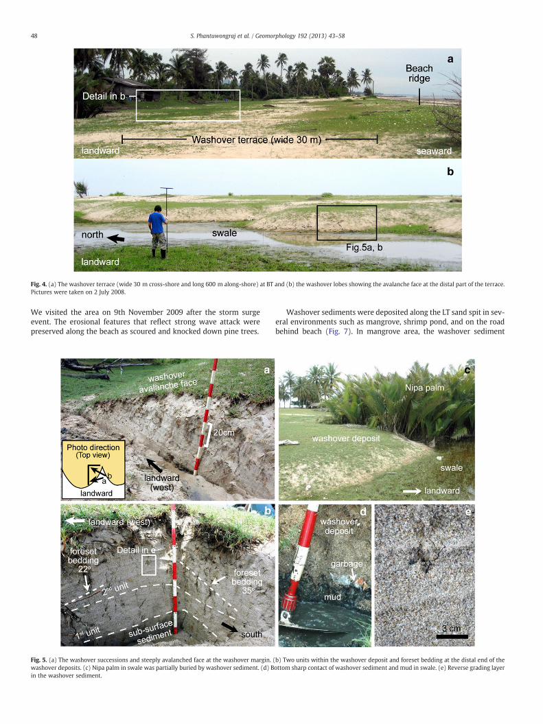
Fig. 4. (a) The washover terrace (wide 30 m cross-shore and long 600 m along-shore) at BT and (b) the washover lobes showing the avalanche face at the distal part of the terrace.Pictures were taken on 2 July 2008.
48 S. Phantuwongraj et al. / Geomorphology 192 (2013) 43–58
We visited the area on 9th November 2009 after the storm surgeevent. The erosional features that reflect strong wave attack werepreserved along the beach as scoured and knocked down pine trees.
Fig. 5. (a) The washover successions and steeply avalanched face at the washover margin. (washover deposits. (c) Nipa palm in swale was partially buried by washover sediment. (d) Bin the washover sediment.
Washover sediments were deposited along the LT sand spit in sev-eral environments such as mangrove, shrimp pond, and on the roadbehind beach (Fig. 7). In mangrove area, the washover sediment
b) Two units within the washover deposit and foreset bedding at the distal end of theottom sharp contact of washover sediment and mud in swale. (e) Reverse grading layer

Fig. 6. (a) Grain size distribution graph of washover sediments and pre-storm surface sediments. (b) Average grain size change from top to bottom within the washover deposit andpre-storm surface sediment. (c) The sampling locations (at scour) in the washover deposit. (d) Mean grain size and sorting characteristics of three groups of sediments (coarse–verycoarse layer, laminae layer and pre-storm surface layer). (e) Contact boundary between the 1st unit and 2nd unit.
49S. Phantuwongraj et al. / Geomorphology 192 (2013) 43–58
was deposited as narrow band parallel to the shore similar to thoserecognized in the washover terrace type classified by Morton andSallenger (2003). Whereas washover deposits found behind thebeach in the shrimp pond and on the road were expressed as small lo-bate features and oriented perpendicular to the shore, and were thusclassified as perched fan type following Morton and Sallenger (2003).
We made a small trench where the washover deposit was foundon the road behind the beach in order to describe the physical charac-teristics and sedimentary structures (Fig. 7d, e). The topography be-hind the beach is exhibited as a slightly flat coastal plain without
swale. Apart from the forested area behind the beach, a compactedsurface road 4–5 m in width was constructed parallel to the shore.Washover sediments were found as a sand sheet with a basal sharpcontact overlain on the pre-surface soil and the road. Grasses buriedat the bottom part of washover sediment were still green, which indi-cated the recent timing of the washover deposit (Fig. 7e). The dimen-sion of washover body was 25 m in length cross-shore and 8 m inwidth parallel to shore. The thickness of the washover sedimentwas relatively uniform at about 15–20 cm on the flat topography(Figs. 7d and 8a).

50 S. Phantuwongraj et al. / Geomorphology 192 (2013) 43–58
Two different sedimentary textures were recognized in thewashover sand, being the fine sand grain unit at the bottom and thecoarse sand grain unit from the middle to the top (Figs. 7e and 8a,b). The fine sand unit was dominated by fine to medium-grainedsand containing rip-up clasts of the underlying soil that were thendispersed upwards into the lower zone near the base of the unit.The erosional contact at the bottom of the first unit was found onlyin the forested area behind the beach but not on the road. The spatiallimit of the erosional contact at the base of washover deposit that wasfound only in the forested area may reflect the difference in overwashflow condition. The compacted surface of the road may act essentiallyas an armored bed with little to no erosion relative to areas awayfrom the road. Additionally, drag on the flow would be significantlyreduced as well when compared to the forested area. The verticalchange in the grain size in the unit shows a normal grading from me-dium sand at the bottom to fine sand at the top. Additionally, in thedistal part, a thin layer of dark organic material was found in the up-permost level of unit (Fig. 8c). The source of dark organic layer maycome from the sub-surface soil in the forested area behind thebeach. This organic layer may indicate a period of waning flow or pos-sibly a falling flood level. The thickness of the 1st unit was confined bythe antecedent topography to about 8 cm in the depression of buriedsoil and 2 cm on a flat road. Subsequently, the second unit, which iscomposed of coarse to very coarse-grained sand, was deposited on
Fig. 7. (a) Washover sediment penetrated into the mangrove area at the head of LT sand spibeach at the middle of LT sand spit (south of study site). (c) Washover deposit on the roadpart (trenching perpendicular to the shoreline). (e) Three layers of washover deposit with
top of the fine to medium-grained sand unit (Fig. 8b). The coarsergrain size in this unit may result from the removal of the fine grainsand from the beach surface by the initial stage of the storm surge,which was then transported to be deposited as the 1st unit and,thus, exposing the less eroded more coarse grain sand on the beach.Subsequently, these exposed coarser sediments were then erodedby the following surges to be deposited as the 2nd unit. The sedimen-tary characteristics of the 2nd unit was characterized as two multiplelayers of coarse sand around 10 cm in thickness which were clearlyseparated by shell laminae at the base of each layer (Figs. 7e and 8d,e). Normal grading, from very coarse to coarse-grained sand at thebottom to medium grained sand at the top, was revealed in bothlayers (Figs. 7e and 8e). Dune bedforms (6 cm height and 50 cm inlength), oriented perpendicular to shoreline, were recognized in themiddle part of the washover deposit. Then, these dunes were gradu-ally transformed into horizontal bedding as it extended further inland(Fig. 8b). The changing of sedimentary structure from dune bedformsurface to structureless at the distal part of the washover depositand the decrease in the overall grain size in the landward directionpresumably reflects the decreased flow velocity.
The washover revealed a sequence of normal grading within thetwo units, where the average grain size of the first unit at the bottomwas finer than the second unit on the top (Fig. 7e). Sorting of sedi-ment in the first unit was also better than the second unit. The
t (north of study site). (b) Washover sediment penetrated into the shrimp pond behindas a perched fan shape. (d) Washover deposit showing landward thinning at the distala normal grading in the vertical direction.
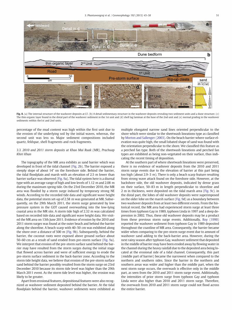
Fig. 8. (a) The internal structure of the washover deposits at LT. (b) A detail sedimentary structure in the washover deposits revealing two sediment units and a dune structure. (c)The thin organic layer found in the distal part of the washover sediment in the 1st unit and (d) shell lag laminae at the base of the 2nd unit and (e) normal grading in the washoversediments within the1st and 2nd units.
51S. Phantuwongraj et al. / Geomorphology 192 (2013) 43–58
percentage of the mud content was high within the first unit due tothe erosion of the underlying soil by the initial waves, whereas, thesecond unit was less so. Major sediment compositions includedquartz, feldspar, shell fragments and rock fragments.
3.3. 2010 and 2011 storm deposits at Khao Mai Ruak (MR), PrachuapKhiri Khan
The topography of the MR area exhibits as sand barrier which wasdeveloped in front of the tidal channel (Fig. 2b). The barrier exposed asteeply slope of about 14° on the foreshore side. Behind the barrier,the tidal floodplain and marsh with an elevation of 2.5 m lower thanbarrier surfacewas observed (Fig. 9a). The tidal system here is a diurnaltypewith an average range of high and low levels of 1.12 m and 2.08 mduring the maximum spring tide. On the 23rd December 2010, the MRarea was flooded by a storm surge induced by temporary strong NEwinds. According to the recorded tide data and significant wave heightdata, the potential storm set-up of 2.58 mwas generated at MR. Subse-quently, on the 29th March 2011, the storm surge generated by lowpressure system in the GOT caused overwashing into the low-lyingcoastal area in the MR site. A storm tide high of 2.32 m was calculatedbased on recorded tide data and significant wave height data. We visit-ed the MR area on 13th June 2011. Evidence of erosion by the 2010 and2011 storm surges was found at the outer beach and behind the barrieralong the shoreline. A beach scarp with 40–50 cm was exhibited alongthe shore over a distance of 500 m (Fig. 9b). Subsequently, behind thebarrier, the coconut roots were exposed above ground surface about50–60 cm as a result of sand eroded from pre-storm surface (Fig. 9a).We interpret that erosion of the pre-storm surface sand behind the bar-rier may have resulted from the storm surges during the initial stagethat flowed across barrier and were of sufficient energy to erode thepre-storm surface sediment in the back-barrier zone. According to thestorm tide height data, we believe that erosion of the pre-storm surfacesand behind the barrier possibly resulted from the storm surge on 23rdDecember 2010 because its storm tide level was higher than the 29thMarch 2011 event. As the storm tide level was higher, the erosion waslikely to be greater.
Apart from erosional features, depositional featureswere also recog-nized as washover sediment deposited behind the barrier. At the tidalfloodplain behind the barrier, washover sediments were exhibited as
multiple elongated narrow sand lines oriented perpendicular to theshore which were similar to the sheetwash lineations type as classifiedbyMorton and Sallenger (2003). On the beach barrier where surface el-evationwas quite high, the small lobated shape of sandwas foundwiththe orientation perpendicular to the shore. We classified this feature asa perched fan type. Both of the sheetwash lineations and perched fantypes are exhibited as being non-vegetated on their surface, thus indi-cating the recent timing of deposition.
At the southern part of where sheetwash lineations were preserved,there is no evidence of washover deposits from the 2010 and 2011storm surge events due to the elevation of barrier at this part beingtoo high (about 2.9–3 m). There is only a beach scarp feature resultingfrom strong wave attack found on the foreshore side. However, at thebackshore side, the old washover deposits, indicated by dense grasson their surface, 50–83 m in length perpendicular to shoreline and2 m in thickness, were deposited on the tidal marsh area (Fig. 9c). inthe distal part, the lobes of old washover deposits were superimposedon the older lobe on the marsh surface (Fig. 9d) as a boundary betweentwowashover deposits from at least two different events. From the his-torical record, the MR area had experienced storm surge at least threetimes from typhoon Gay in 1989, typhoon Linda in 1997 and a deep de-pression in 2002. Thus, these old washover deposits may be a productfrom these previous storm surge events. Additionally, Roy (1990)reported the washover sediment from typhoon Gay in 1989 depositedthroughout the coastline of MR area. Consequently, the barrier becamewider when comparing to the pre-storm surge event due to amount ofwashover sand adding to the back-barrier area. However, during thenext rainy season after typhoon Gay, washover sediment that depositedin themiddle of barriermay have been eroded awaybyflowingwater inthe channel during the heavy rainfall due to the deposited area being lo-cated at the erosional side of a tidal channel. Consequently, this part(middle part of barrier) became the narrowest when compared to thenorthern and southern sides. Since the barrier in the northern andsouthern areas was wider and higher than the middle part, when thenext storm surge occurs, the overwash is effective only in the middlepart, as seen from the 2010 and 2011 storm surge event. Additionally,the intensities of prior storm surge from typhoon Gay and typhoonLinda were also higher than 2010 and 2011 storm surge. Therefore,the overwash from 2010 and 2011 storm surge could not flood acrossthe entire barrier.

Fig. 9. (a) The cross-shore topography, breach point and washover deposits at MR, (b) the 40 cm high beach scarp along the beach, (c) the former washover deposits before 23December 2010 that terminated in the marsh, (d) margin of the former washover deposits from two different events on the marsh surface and (e) the breach point at thebeach resulting from strong wave attack during NE monsoon surge. Pictures were taken on 13 June 2011.
52 S. Phantuwongraj et al. / Geomorphology 192 (2013) 43–58
In contrast, in the sheetwash lineations area, the topography isexpressed as a narrow barrier with surface elevation lower than thesouthern part. Consequently, this part of barrier is the most affectedby storm surge attack, as can be seen from the breach of the barrier(Fig. 9e). A narrow and elongated zone of erosion and deposition assand lineations was found behind the barrier on the tidal floodplainsurface (Fig. 10a). These sheetwash lineations were straight andshowed a flow direction from the NE to the SW (Fig. 10b). The crestof the sheetwash lineations was 20–30 cm in thickness and the gapbetween each lineation was 50–70 cm in width.
Behind the breached barrier, we found another washover sedimentpreserved as a perched fan shape overlain on the sheetwash lineations(Fig. 10c, d). Based on the storm impact scale for barrier islands pro-posed by Sallenger (2000), perched fan and sheetwash features resultfrom different storm impacts as overwash regime and inundation re-gime, respectively. Sallenger (2000) also stated that the overwash re-gime occurs when wave run-up superimposed on the water levelexceeds the beach or dune crest, which can transport sediment a dis-tance of ten to hundreds meters inland. In contrast, the inundation re-gime occurs when the barrier or beach is completely flooded by aseaward-running water body which can transport sediment over a dis-tance as far as 1 km inland. As stated before that the intensity of the2010 storm surge was higher than the storm surge 2011, and accordingto the storm impact scale (Sallenger, 2000), the sheetwash lineations atthis site should have resulted from the storm surges on the 23rd De-cember 2010 and the perched fan deposit probably resulted from the29th March 2011 storm surge.
The compaction of sediment in perched fan was very poor whencompared to the sheetwash lineations. The new perched fan on thebackshore showed a bottom sharp contact on the pre-storm surfacebrownish medium to coarse-grained sand (Fig. 10e). Floating mate-rials, such as garbage and part of a dead tree, possibly mixed withthe overwash flow, were found on the surface of the perched fan.The thickness conformed to the backshore topography with its strat-ification dipping landward.
In the distal part, the perched fan was spilt into 4–5 lobes at a dis-tance of 70 m parallel to the shoreline (Fig. 10c, d). Trenching thererevealed twelve sub-horizontal layers of very coarse grained sandwith numerous laminae dipping landwards (Fig. 10e). Each layershowed a reverse grading of grain size from medium to coarse sand
laminae at the bottom to very coarse sand at the top (Fig. 10f–h). Aseries of sub-horizontal layers and laminations were preserved inthe middle part of the washover deposit. The thickest layer wasfound at the base and became thinner towards the top of unit, rangingfrom 12 to 0.8 cm thick (Fig. 10e–g). In the distal part, the thicknessof washover sediment increased slightly by about 10 cm and revealeda foreset bedding projecting inland with a 9° dip angle (Fig. 10e). Mudcontent was rare due to the absence of any organic material from thesediment source zone. Quartz was the major composition found inthe overall deposit, whereas shell fragments were concentrated onlywithin the very coarse sand layer (Fig. 10g). Sorting was moderateto poor in the very coarse sand layer while the medium to coarsesand laminae yielded better sorting.
4. Discussion
In this study, three types of washover deposits (washover terrace,perched fan and sheetwash lineations) from three different geomor-phic settings were deposited at a maximum distance of 100 m fromthe shoreline. A washover terrace with thick-bedded sand, thicknessranging from 60 to 80 cm, was found at BT, whereas perched fanswith a thickness ranging over 15–50 cm were found at LT and MR.Lastly, elongate narrow sheetwash lineations running parallel to theflow direction were found at MR.
Sedimentary characteristics also showed the distinctive successionsthat corresponded to the topography andwere classified into two typesas (i) a thick-bedded sand, thickness ranging from 50 to 80 cm havingmultiple reverse grading layers which show laminae at the bottom ofeach layer, and (ii) a medium-bedded sand, thickness ranging from 15to 20 cm which shows multiple normal grading layers. Here, in thispart, we discuss the controlling factors of washover preservation type,flow condition and sedimentary characteristics from each location.The differences in the geomorphic settings, washover type, flow condi-tions and sedimentary characteristics are summarized in Table 1.
4.1. Preservation type and flow condition of storm washover deposits
We suggest that the different patterns of the washover deposits arerelated to a series of controlling factors, i.e. topography, bathymetry andflow depth, of which coastal topography is the major factor — a notion
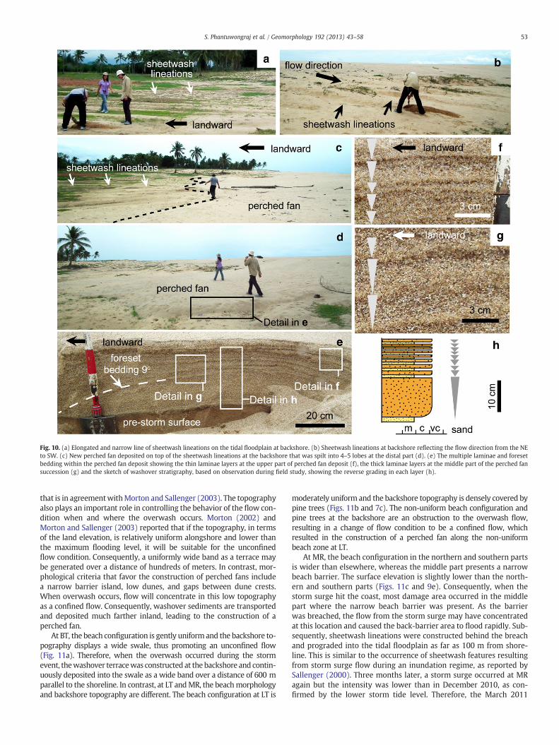
Fig. 10. (a) Elongated and narrow line of sheetwash lineations on the tidal floodplain at backshore. (b) Sheetwash lineations at backshore reflecting the flow direction from the NEto SW. (c) New perched fan deposited on top of the sheetwash lineations at the backshore that was spilt into 4–5 lobes at the distal part (d). (e) The multiple laminae and foresetbedding within the perched fan deposit showing the thin laminae layers at the upper part of perched fan deposit (f), the thick laminae layers at the middle part of the perched fansuccession (g) and the sketch of washover stratigraphy, based on observation during field study, showing the reverse grading in each layer (h).
53S. Phantuwongraj et al. / Geomorphology 192 (2013) 43–58
that is in agreementwithMorton and Sallenger (2003). The topographyalso plays an important role in controlling the behavior of the flow con-dition when and where the overwash occurs. Morton (2002) andMorton and Sallenger (2003) reported that if the topography, in termsof the land elevation, is relatively uniform alongshore and lower thanthe maximum flooding level, it will be suitable for the unconfinedflow condition. Consequently, a uniformly wide band as a terrace maybe generated over a distance of hundreds of meters. In contrast, mor-phological criteria that favor the construction of perched fans includea narrow barrier island, low dunes, and gaps between dune crests.When overwash occurs, flow will concentrate in this low topographyas a confined flow. Consequently, washover sediments are transportedand deposited much farther inland, leading to the construction of aperched fan.
At BT, the beach configuration is gently uniform and the backshore to-pography displays a wide swale, thus promoting an unconfined flow(Fig. 11a). Therefore, when the overwash occurred during the stormevent, thewashover terracewas constructed at the backshore and contin-uously deposited into the swale as a wide band over a distance of 600 mparallel to the shoreline. In contrast, at LT andMR, the beachmorphologyand backshore topography are different. The beach configuration at LT is
moderately uniform and the backshore topography is densely covered bypine trees (Figs. 11b and 7c). The non-uniform beach configuration andpine trees at the backshore are an obstruction to the overwash flow,resulting in a change of flow condition to be a confined flow, whichresulted in the construction of a perched fan along the non-uniformbeach zone at LT.
At MR, the beach configuration in the northern and southern partsis wider than elsewhere, whereas the middle part presents a narrowbeach barrier. The surface elevation is slightly lower than the north-ern and southern parts (Figs. 11c and 9e). Consequently, when thestorm surge hit the coast, most damage area occurred in the middlepart where the narrow beach barrier was present. As the barrierwas breached, the flow from the storm surge may have concentratedat this location and caused the back-barrier area to flood rapidly. Sub-sequently, sheetwash lineations were constructed behind the breachand prograded into the tidal floodplain as far as 100 m from shore-line. This is similar to the occurrence of sheetwash features resultingfrom storm surge flow during an inundation regime, as reported bySallenger (2000). Three months later, a storm surge occurred at MRagain but the intensity was lower than in December 2010, as con-firmed by the lower storm tide level. Therefore, the March 2011

Table 1Summary of geomorphic setting, washover type, flow condition, and sedimentary characteristic in washover deposits from each area.
Features Ban Takrop Laem Talumphuk Khao Mai Ruak 1st event Khao Mai Ruak 2nd event
Topographic setting Prograded shoreline Sand spit Beach barrier Beach barrierBackshore topography Swale lower from beach ridge 2 m Flat coastal plain
higher than beach ridgeTidal flood plain lowerfrom beach ridge 2.5 m
Tidal flood plain lower frombeach ridge 2.5 m
Erosional features Beach erosion Beach erosion, scour Beach scarp,Breached barrier
Beach scarp
Storm impact regime Overwash regime⁎ Overwash regime⁎ Inundation regime⁎⁎ Overwash regime⁎
Flow confinement Unconfined flow Confined flow Unconfined flow Confined flowWashover type Washover terrace Perched fan Sheetwash Perched fanDeposit thickness 60–80 cm 15–20 cm 30 cm at crest of
sand lineations50–30 cm
Number of layers 11 3 – 12Vertical grading in layer Reverse grading Normal grading – Reverse gradingSedimentary structure Lamination, foreset bedding,
sub-horizontal bedding,wavy bedding
Horizontal bedding,dune bedform
– Lamination, foreset bedding,sub-horizontal bedding
Bedding Inclination Landward Landward – LandwardRip-up clasts None Present at bottom unit None NoneBasal contact Sharp contact Sharp contact, erosional contact Sharp contact Sharp contactShell laminae None Common None NoneGeometry Sand sheet, lobate sand, thickness
increasing in the depressionLobate sand, landward thinning Elongate narrow parallel
to flow directionLobate sand, thicknessincreasing in the depression
Lateral deposition Extensive Patchy Discontinuous Patchy
⁎ Overwash regime occurring when wave run up superimposed on the water level exceeds the beach or dune crest.⁎⁎ Inundation regime occurring when the barrier or beach is completely flooded by seaward running water body.
54 S. Phantuwongraj et al. / Geomorphology 192 (2013) 43–58
storm surge flowed as the overwash regime. As the barrier had stillnot recovered from the prior storm surge, the March 2011 stormsurge focused at the same breached barrier zone. This breach promot-ed the confined flow, thus the washover sediment was deposited as asmall lobe perpendicular to shoreline similar to those of the perchedfan type described by Morton and Sallenger (2003).
To confirm our findings on the relationship between topographicfactors and the pattern of washover deposits, we visited the BT andMR areas again in early January 2012 soon after the storm surge in-duced by temporary strong NE winds in December 2011. This stormsurge generated overwash flow across beach in the low-lying coastalarea from Prachuap Khiri Khan to Narathiwat provinces. At BT, thenew washover deposits were found in the backshore as a terrace pat-tern similar to those previously described from storm surge events in2007 and 2008. The new 2011 washover terrace at BT deposited ontop of the 2008 washover deposits and extended further inland tothe distal part as washover lobes (Fig. 12a, b). At MR, we also ob-served the new washover deposit, resulting from December 2011storm, as a perched fan shape which was similar to the March 2011washover deposit (Fig. 12c, d). Many marine shells transported byoverwash flow were still preserved in the distal part of perched fan.Similar pattern of washover deposit from the two events in thesame coastal topographic condition as found at BT and MR confirmedthat the coastal topography has influenced the specific patterns ofwashover deposit. The repeat in the same pattern of washover depos-it from different storms in the same affected area has also beenreported from the US coasts (Hardin et al., 1976; Morton and Paine,1985; Morton and Sallenger, 2003).
However, the topographic condition is not the only factor thatinfluenced the washover depositional pattern since we had found loca-tions with the same narrow beach topography where new sedimentwas deposited as a perched fan on top of the sheetwash lineations.This observation suggested that the magnitude of the storm surge isalso important. The sheetwash lineations from the December 2010storm surge indicated the high magnitude of the storm surge where ithad more power in breaching the beach barrier to a distance as far as100 m parallel to the shoreline. In contrast, the new perched fan de-posits on March 2011 were indicative of a lower magnitude of stormsurge that did not cause any new scour to the beach.
According to the preserved types of washover deposits, theperched fan and washover terrace yield a similar geometry of sand
sheet that showed a continuity of lateral deposition. In contrast, thegeometry of sheetwash lineations was narrowed and elongated paral-lel to the flow direction resulting either from deposition of sand erod-ed from the adjacent beach/dune system or from the redistribution ofsand eroded locally (Morton and Sallenger, 2003). As a result of thediscontinuity in the lateral deposition, sheetwash lineations aremore difficult to preserve and identify in the geological record whencompared to perched fans and washover terraces.
4.2. Sedimentary characteristics of storm washover deposits
We found that the lateral discontinuity in thedeposition of sheetwashlineation is one significant characteristic making it difficult for these fea-tures to be preserved. In this section, we focus mainly on the descriptionof sedimentary characteristics found extensively within the perched fansand washover terraces.
Two types of sedimentary characteristics were identified from thethree areas, including (i) a thick-bedded sand, 50–80 cm in thickness,showing multiple reverse grading layers and (ii) a medium-beddedsand with thickness ranging from 15 to 20 cm and showing multiplenormal grading layers. This characteristic of multiple grading (reverseor normal) layers is also similar to the storm washover deposit char-acteristics reported from previous study elsewhere, as stated bySchwartz (1982), Leatherman and Williams (1983), Sedgwick andDavis (2003), Morton et al. (2007) from the USA and Switzer andJones (2008b) from Australia. The formation of the thick-beddedsand with several sand laminae at BT and MR (see locations inFigs. 4 and 9) is thought to have been influenced by the coastal topog-raphy and a high energy flow of storm surge. At both places, thebackshore topography is exhibited as a swale (at BT) and a widetidal floodplain (at MR) with surface elevation of 2–2.5 m lowerthan the maximum beach ridge. These topographic conditions, espe-cially the lower backshore topography, played a suitable role for trap-ping the sediment and allowing it to be deposited as a thick-beddedwashover terrace and perched fan, as found at BT and MR, respective-ly (Fig. 11a, c). Additionally, the existence of a large swale behind thebeach is also a good preservation zone for sediment arising from highenergy processes, such as a storm and tsunami, to be deposited andlast longer in the geological record (Phantuwongraj and Choowong,2012).

Fig. 11. Cross-shore topography and beach ridge configuration from three areas that control the preservation type and sedimentary characteristics of washover deposits. (a) A largeswale behind the beach and uniform beach ridge configuration result in a washover terrace deposit at BT. (b) A flat and high coastal plain topography behind beach with anon-uniform beach ridge configuration results in perched fan deposits at LT. (c) The low-lying tidal floodplain behind the beach barrier associated with a non-uniform beachridge configuration resulting in sheetwash lineations and perched fan deposition at MR. Beach ridge configurations (looking from seaward to landward) and washover preservationtypes (looking from top view). Cross-shore profile at BT is made from survey data, whereas BT and LT profiles are from qualitative sketch.
55S. Phantuwongraj et al. / Geomorphology 192 (2013) 43–58
Reverse grading is one common feature observed in stormwashoverdeposits, as previously reported by Schwartz (1975), Leatherman andWilliams (1983), Sedgwick and Davis (2003), Morton et al. (2007),Phantuwongraj et al. (2008) and Spiske and Jaffe (2009). Leathermanand Williams (1983) proposed that reverse grading in washover sedi-ments that show a heavy mineral layer at the base of units observedfrom the Atlantic coastline of USA resulted from an in situ sorting pro-cess which occurredwhen quartz and heavy minerals were initially de-posited as a mixture, then post-depositional sorting allowed the heavyminerals towork their way through thematrix and become concentrat-ed on the bottom of the unit. Sedgwick and Davis (2003) also found re-verse grading in washover sediments from Florida, USA that show theconcentrated heavy mineral in the unit which tended to be smaller ingrain size than the overlying sediments. They described that this kindof reverse grading is a result of the basal concentrations of smallerheavy mineral particles that have settled out of flow before the quartzand carbonate fractions. At BT and MR, several sand laminae werefound within the washover sediment, which are expressed as multiplereverse grading. These sand laminae, in which the grain size is smallerthan the overlying sediments, were found at the base of each layer sim-ilar to the reverse grading in the washover sediment reported byLeatherman and Williams (1983) and Sedgwick and Davis (2003).
According to the sedimentary transport mechanism of storm de-position that is dominantly moved by traction processes (Morton etal., 2007), the sediments are thus concentrated at the base of flow.In this study, we suggest that the reverse grading in washover sedi-ment may result from dynamic sorting during bedload transportunder the condition of high grain concentration in the overwashflow. As the sediments are transported as traction load, the coarsergrains preferentially roll over finer grains, thus resulting in reversegrading. Additionally, the sudden change of ground surface elevationabout 2–2.5 m from the beach ridge to the behind low-lying swaleduring overwash may also induce the dynamic sorting of sediment
as well. Each layer of sand with reverse grading at BT and MR reflectsthe pulsation of overwash flow in the overwash regime condition bythe wave run-up superimposed on the water level exceeding thebeach or dune crest.
In contrast, the beach ridge at LT is relatively small comparedwith BTand MR. The backshore topography also exhibited as flat coastal plainwithout swale (Fig. 11b). Small and narrow beach ridge implies thatthe volumeof sediment supply to form the beach at LTwas also relative-ly lower than that of BT andMR.Moreover, theflat and high topographybehind beach is also not favorable for trapping the washover sediment.Therefore, when the overwash occurred, the washover sand was gener-ated asmedium-bedded sandwith thickness ranging from 15 to 20 cm,which is thinner than BT andMR due to the limitation in sediment sup-ply and the high and flat backshore topography (Fig. 11b). As suggestedearlier, the high grain concentration and the backshore slope conditionwere thought to influence the occurrence of reverse grading at BT andMR, however at LT these two factors were totally ruled out. Due to thelow grain concentration in the overwash flow and relatively uniformbackshore topography, these conditions probably favored the formationof normal grading at LT area (Fig. 11b). The difference inwashover pres-ervation style and depositional characteristics are the result if the differ-ence in coastal morphologies, vegetation types and densities andsediment properties, as stated by Wang and Horwitz (2007).
The sedimentary structures found in the thick-bedded washoverdeposits at BT and MR include sub-horizontal bedding, reverse grad-ing, lamination, foreset bedding and wavy bedding. At LT, wherewashover deposition is exhibited as medium bedded, the sedimenta-ry structures are composed of normal grading, horizontal bedding,rip-up clasts, and dune bedforms. These sedimentary structures aresimilar to the common sedimentary structures of storm washover de-posits as stated earlier, except rip-up clasts that are not oftenreported for storm deposits. From our three study sites, washoversuccessions were expressed in the inclined bedding in a landward

Fig. 12. Series of photographs taken from 2009 to 2012 and sketch maps showing similar pattern and shape of washover deposits in the same topographic area resulting from twodifferent NE monsoon surge events. (a) Washover deposit as a terrace at BT resulting from the 2007, 2008 and 2011 NE monsoon surge. (b) Sketch map of BT area demonstrates theincrease in landward penetration of washover sediment from 2009 to 2012. (c) Washover deposits as a perched fan shape behind beach at MR area which resulting from the 2010and 2011 NE monsoon surge. (d) Sketch map of MR area demonstrates the increase in landward penetration of washover sediment from year 2011 to 2012.
56 S. Phantuwongraj et al. / Geomorphology 192 (2013) 43–58
direction with a basal sharp contacts that is commonly recognized asa typical feature of stormwashover deposit elsewhere (e.g., Schwartz,1975; Sedgwick and Davis, 2003; Wang and Horwitz, 2007).
The occurrence of similar sedimentary characteristics of stormwashover deposits from Thailand and different places around theworld confirms the same storm-induced processes that often result inthe similar sedimentary characteristics. When comparing these typicalstorm depositional characteristics to the other high energy process,such as tsunami deposits, there are several features that also found intsunami deposits, including normal grading, reverse grading, lamination,and landward inclination (e.g. Atwater and Moore, 1992; Hindson et al.,1996; Bondevik et al., 1997; Bourgeois et al., 1999; Clague et al., 2000;Nanayama et al., 2003; Nanayama and Shigeno, 2006; Higman andBourgeois, 2008; Monecke et al., 2008; Sawai et al., 2009; Fujino et al.,2010; Naruse et al., 2010; Srisutam and Wagner, 2010). However, inthis study we found some features that can be used to differentiatestorm from tsunami deposits, including the number of layers, the multi-ple reverse grading layer, and foreset bedding structure. The number oflayers in the storm deposits tended to be higher than in the tsunamideposits, which is confirmed by the eleven to twelve layers of stormdeposits found in BT and MR, which is similar to the multiple layers ofstorm deposits found in USA and Australia (Morton et al., 2007;Switzer and Jones, 2008b). Furthermore, the multiple reverse gradinglayers and foreset bedding structure of storm washover deposits fromBT and MR also suggested that these structures are more common instorm deposits than those we found in tsunami deposits, in agreementwith those reported by Morton et al. (2007).
5. Conclusions
Small-scale washover sediments resulting from storm surges during2007–2011were observed from the southern part of Thailand at (1) BT,Surat Thani, (2) LT, Nakhon Si Thammarat, and (3) MR, Prachuap KhiriKhan on the eastern side of Thailand Peninsula. The geomorphic settingof these three areas included a prograded shoreline at BT, sand spit at LTand beach barrier at MR. Overwash flow induced by (i) temporarystrong NE wind during the NE monsoon season in 2007–2010 and (ii)a low-pressure system in 2011 that occurred along the shoreline inthe area where the coastal topography elevation is not higher than2.5 m above the MSL. The maximum inundation distances from thestorm surges are limited to 300 m from the shoreline. Three types ofwashover deposits, being perched fan at MR and LT, washover terraceat BT and sheetwash lineations at MR, were found behind the beach ata distance of 100 m from the shoreline.
Thewashover sediments displayed two types of sedimentary charac-teristics, (i) a thick-bedded sand, thickness ranging from 50 to 80 cmhaving multiple reverse grading layers and laminae at the bottom ofeach layer, as seen at BT andMR, and (ii) a medium-bedded sand, thick-ness ranging from 15 to 20 cm, which shows multiple normal gradinglayer, as seen at LT. The sedimentary structures found in the thick-bedded washover deposits at BT and MR included sub-horizontal bed-ding, reverse grading, lamination, foreset bedding and wavy bedding.Whereas, normal grading, horizontal bedding and dune bedform werecommon in the medium-bedded washover sand at LT. Rip-up clastswere also found in the washover deposit, particularly in the bottom

57S. Phantuwongraj et al. / Geomorphology 192 (2013) 43–58
unit where the mud supply was available. Washover successions werecharacterized by inclined bedding in a landward direction with a basalsharp contact.
Coastal topography, especially the beach configuration, which con-trols the flow condition during the overwash, was seemingly the majorfactor that influenced the preservation type ofwashover deposits behindthe beach. A uniform beach configuration that promoted an unconfinedflowwas suitable for generating thewashover terrace, as found at BT. Incontrast, a non-uniform beach configuration that promoted a confinedflow was appropriate for the formation of a perched fan deposit, as ob-served at LT andMR.However, themagnitude of storm surge canalso in-fluence the washover preservation type, as we observed perched fandeposits superimposed on sheetwash lineations in the same place atMR. The sedimentary characteristics of the washover successions werealso influenced by the coastal topography, including the beach ridge el-evation and backshore topography. A high beach ridge associated with alarge swale at the backshore was suitable for trapping the sediment toform a thick-bedded sand of washover deposit, as recognized in 50–80 cm thick washover sediments at BT and MR. In contrast, a smallbeach ridge with a high and uniformly flat backshore topography pro-moted the deposition of a medium-bedded sand, as seen from the 15–20 cm-thick washover deposit at LT. Reverse grading at BT and MRwas interpreted as a result of dynamic sorting during bed load transportinfluenced by a high grain concentration in the overwash flow andbackshore slope condition. In contrast, at LT, low grain concentrationand low backshore slope condition led to the formation of normal grad-ing in the washover succession.
Acknowledgments
The Royal Golden Jubilee PhD program (grant no. PHD/0016/2552)provides funds to SP. This work was jointly sponsored to MC by theThailand Research Fund (TRF: RMU5380020), Integrated InnovationAcademic Center: IIAC Chulalongkorn University Centenary AcademicDevelopment Project (CU56-CC04), the Higher Education Promotionand National Research University Project of Thailand, Office of theHigher Education Commission (CC508B) and the Thai GovernmentStimulus Package 2 (TKK2555: PERFECTA). We thank the GeologicalSurvey of Japan (GSJ) at Tsukuba, for the use of the Camsizer. TheJapan Student Services Organization (JASSO) provided financial supportfor SP during laboratory work in Japan. University of Tsukuba also pro-vided the laboratory facilities for preparing sediment samples. Thanksare also extended to Prof. Andrew Plater, Editor, Dr. Adam Switzer andanonymous reviewer for a thorough review that greatly improved themanuscript.
References
Andrews, P.B., 1970. Facies and Genesis of a Hurricane Washover Fan, St. Joseph Island,Central Texas Coast. Report of Investigations, 67. Bureau of Economic Geology,University of Texas at Austin.
Atwater, B.F., Moore, A.L., 1992. A tsunami about 1000 years ago in Puget Sound, Wash-ington. Science 258, 1614–1617.
Bondevik, S., Svendsen, J.I., Mangerud, J., 1997. Tsunami sedimentary facies depositedby the Storegga tsunami in shallow marine basins and coastal lakes, westernNorway. Sedimentology 44, 1115–1131.
Bourgeois, J., Petroff, C., Yeh, H., Titov, V., Synolakis, C.E., Benson, B., Kuroiwa, J., Lander,J., Norabuena, E., 1999. Geologic setting, field survey and modeling of theChimbote, Northern Peru, Tsunami of 21 February 1996. Pure and Applied Geo-physics 154, 513–540.
Campbell, C.V., 1967. Lamina, laminaset, bed, and bedset. Sedimentology 8, 7–26.Choowong, M., Murakoshi, N., Hisada, K., Charusiri, P., Daorerk, V., Charoentitirat, T.,
Chutakositkanon, V., Jankaew, K., Kanjanapayont, P., 2007. Erosion and depositionby the 2004 Indian Ocean tsunami in Phuket and Phang-nga provinces, Thailand.Journal of Coastal Research 23, 1270–1276.
Choowong, M., Murakoshi, N., Hisada, K., Charoentitirat, T., Charusiri, P., Phantuwongraj,S., Wongkok, P., Choowong, A., Subsayjun, R., Chutakositkanon, V., Jankaew, K.,Kanjanapayont, P., 2008a. Flow conditions of the 2004 Indian Ocean tsunami inThailand, inferred from capping bedforms and sedimentary structures. Terra Nova20, 141–149.
Choowong, M., Murakoshi, N., Hisada, K.I., Charusiri, P., Charoentitirat, T., Chutakositkanon,V., JankaeW, K., Kanjanapayon, P., Phantuwongraj, S., 2008b. 2004 Indian Ocean tsuna-mi inflow and outflow at Phuket, Thailand. Marine Geology 248, 179–192.
Clague, J.J., Bobrowsky, P.T., Hutchinson, I., 2000. A review of geological records of largetsunamis at Vancouver Island, British Columbia, and implications for hazard. Qua-ternary Science Reviews 19, 849–863.
Claudino-Sales, V., Wang, P., Horwitz, M.H., 2008. Factors controlling the survival ofcoastal dunes during multiple hurricane impacts in 2004 and 2005: Santa Rosabarrier island, Florida. Geomorphology 95, 295–315.
Davis Jr., R.A., Andronaco, M., Gibeaut, J.C., 1989. Formation and development of a tidalinlet from a washover fan, west-central Florida coast, USA. Sedimentary Geology65, 87–94.
Deery, J.R., Howard, J.D., 1977. Origin and character of washover fans on the GeorgiaCoast, USA. Gulf Coast Association of Geological Societies Transactions 27,259–271.
Fujino, S., Naruse, H., Matsumoto, D., Sakakura, N., Suphawajruksakul, A., Jarupongsakul,T., 2010. Detailed measurements of thickness and grain size of a widespread onshoretsunami deposit in Phang-nga Province, southwestern Thailand. Island Arc 19,389–398.
Gelfenbaum, G., Jaffe, B., 2003. Erosion and sedimentation from the 17 July, 1998 PapuaNew Guinea tsunami. Pure and Applied Geophysics 160, 1969–1999.
Goff, J., McFadgen, B.G., Chague-Goff, C., 2004. Sedimentary differences between the2002 Easter storm and the 15th-century Okoropunga tsunami, southeasternNorth Island, New Zealand. Marine Geology 204, 235–250.
Hardin, J.D., Sapp, C.D., Emplaincourt, J.L., Richter, K.E., 1976. Shoreline and BathymetricChanges in the Coastal Area of Alabama. Information Series, 50. Geological Surveyof Alabama.
Hayes, M.O., 1967. Hurricanes as geological agents: case studies of Hurricanes Carla,1961, and Cindy, 1963. Report of Investigations, 61. Bureau of Economic Geology,University of Texas at Austin.
Higman, B., Bourgeois, J., 2008. Chapter 6 — Deposits of the 1992 Nicaragua Tsunami.In: Shiki, T., Tsuji, Y., Yamazaki, T., Minoura, K. (Eds.), Tsunamiites. Elsevier, Am-sterdam, pp. 81–103.
Hindson, R.A., Andrade, C., Dawson, A.G., 1996. Sedimentary processes associated withthe tsunami generated by the 1755 Lisbon earthquake on the Algarve coast, Portugal.Physics and Chemistry of the Earth 21, 57–63.
Jankaew, K., Atwater, B.F., Sawai, Y., Choowong, M., Charoentitirat, T., Martin, M.E.,Prendergast, A., 2008. Medieval forewarning of the 2004 Indian Ocean tsunami inThailand. Nature 455, 1228–1231.
Kahn, J.H., Roberts, H.H., 1982. Variations in storm response along a microtidal trans-gressive barrier-island arc. Sedimentary Geology 33, 129–146.
Komatsubara, J., Fujiwara, O., Takada, K., Sawai, Y., Aung, T.T., Kamataki, T., 2008. His-torical tsunamis and storms recorded in a coastal lowland, Shizuoka Prefecture,along the Pacific Coast of Japan. Sedimentology 55, 1703–1716.
Kortekaas, S., Dawson, A.G., 2007. Distinguishing tsunami and storm deposits: an ex-ample from Martinhal, SW Portugal. Sedimentary Geology 200, 208–221.
Leatherman, S.P., Williams, A.T., 1977. Lateral textural grading in overwash sediments.Earth Surface Processes and Landforms 2, 333–341.
Leatherman, S.P., Williams, A.T., 1983. Vertical sedimentation units in a barrier islandwashover fan. Earth Surface Processes and Landforms 8, 141–150.
Monecke, K., Finger, W., Klarer, D., Kongko, W., McAdoo, B.G., Moore, A.L., Sudrajat, S.U.,2008. A 1,000-year sediment record of tsunami recurrence in northern Sumatra.Nature 455, 1232–1234.
Morton, R.A., 1976. Effects of Hurricane Eloise on beach and coastal structures, FloridaPanhandle. Geology 4, 277–280.
Morton, R.A., 1978. Large-scale rhomboid bed forms and sedimentary structures asso-ciated with hurricane washover. Sedimentology 25, 183–204.
Morton, R.A., 2002. Factors controlling storm impacts on coastal barriers and beaches: apreliminary basis for near real-time forecasting. Journal of Coastal Research 18,486–501.
Morton, R.A., Paine, J.G., 1985. Beach and vegetation-line changes at Galveston Island,Texas. Erosion, Deposition, and Recovery from Hurricane Alicia. : Geological Circular,85. Bureau of Economic Geology, The University of Texas at Austin.
Morton, R.A., Sallenger Jr., A.H., 2003. Morphological impacts of extreme storms onsandy beaches and barriers. Journal of Coastal Research 19, 560–573.
Morton, R.A., Gelfenbaum, G., Jaffe, B.E., 2007. Physical criteria for distinguishing sandytsunami and storm deposits using modern examples. Sedimentary Geology 200,184–207.
Nanayama, F., Shigeno, K., 2006. Inflow and outflow facies from the 1993 tsunami insouthwest Hokkaido. Sedimentary Geology 187, 139–158.
Nanayama, F., Shigeno, K., Satake, K., Shimokawa, K., Koitabashi, S., Miyasaka, S., Ishii,M., 2000. Sedimentary differences between the 1993 Hokkaido-nansei-oki tsuna-mi and the 1959 Miyakojima typhoon at Taisei, southwestern Hokkaido, northernJapan. Sedimentary Geology 135, 255–264.
Nanayama, F., Satake, K., Furukawa, R., Shimokawa, K., Atwater, B.F., Shigeno, K.,Yamaki, S., 2003. Unusually large earthquakes inferred from tsunami depositsalong the Kuril trench. Nature 424, 660–663.
Naruse, H., Fujino, S., Suphawajruksakul, A., Jarupongsakul, T., 2010. Features and forma-tion processes of multiple deposition layers from the 2004 Indian Ocean Tsunami atBan Nam Kem, southern Thailand. Island Arc 19, 399–411.
Phantuwongraj, S., Choowong, M., 2012. Tsunamis versus storm deposits from Thai-land. Natural Hazards 63, 31–50.
Phantuwongraj, S., Choowong, M., Chutakositkanon, V., 2008. Possible storm depositsfrom Surat Thani and Nakhon Si Thammarat provinces, the southern peninsularThailand. In: Choowong, M., Thitimakorn, T. (Eds.), Proc Inter Sym on Geo Resand Envi of Asian Terranes, Bangkok, Thailand, pp. 395–399.

58 S. Phantuwongraj et al. / Geomorphology 192 (2013) 43–58
Phantuwongraj, S., Choowong, M., Silapanth, P., 2010. Geological evidence of sea-levelchange: a preliminary investigation at Panang Tak area, Chumphon province, Thai-land. The 117th Annu Meet of the Geol Soc of Jpn, Toyama, Japan, p. 185.
Roy, P.S., 1990. Offshore minerals exploration in the Gulf of Thailand: review of Quater-nary geology of the coast and offshore seabed in exploration area 2. Mission Re-port. UNESCO.
Sallenger Jr., A.H., 2000. Storm impact scale for barrier islands. Journal of Coastal Re-search 16, 890–895.
Sawai, Y., Jankaew, K., Martin, M.E., Prendergast, A., Choowong, M., Charoentitirat, T.,2009. Diatom assemblages in tsunami deposits associated with the 2004 IndianOcean tsunami at Phra Thong Island, Thailand. Marine Micropaleontology 73,70–79.
Schwartz, R.K., 1975. Nature and Genesis of Some Storm Washover Deposits. TechnicalMemo, 61. U.S. Army, Corps of Engineers, Coastal Engineering Research Center.
Schwartz, R.K., 1982. Bedform and stratification characteristics of some modern small-scale washover sand bodies. Sedimentology 29, 835–849.
Sedgwick, P.E., Davis, R.A., 2003. Stratigraphy of washover deposits in Florida: implica-tions for recognition in the stratigraphic record. Marine Geology 200, 31–48.
Shanmugam, G., 2012. Process-sedimentological challenges in distinguishing paleo-tsunami deposits. Natural Hazards 63, 5–30.
Spiske, M., Jaffe, B.E., 2009. Sedimentology and hydrodynamic implications of a coarse-grained hurricane sequence in a carbonate reef setting. Geology 37, 839–842.
Srisutam, C., Wagner, J.-F., 2010. Tsunami sediment characteristics at the ThaiAndaman Coast. Pure and Applied Geophysics 167, 215–232.
Switzer, A.D., Jones, B.G., 2008a. Large-scale washover sedimentation in a freshwaterlagoon from the southeast Australian coast: sea-level change, tsunami or excep-tionally large storm? The Holocene 18, 787–803.
Switzer, A.D., Jones, B.G., 2008b. Setup, deposition, and sedimentary characteristics oftwo storm overwash deposits, Abrahams Bosom Beach, Southeastern Australia.Journal of Coastal Research 24, 189–200.
Thieler, E.R., Young, R.S., 1991. Quantitative evaluation of geomorphological changes inSouth Carolina after Hurricane Hugo. Journal of Coastal Research 8, 187–200 (Spe-cial Issue).
Tkalich, P., Vethamony, P., Babu, M.T., Malanotte-Rizzoli, P., 2012. Storm surges in theSingapore Strait due to winds in the South China Sea. Natural Hazards. http://dx.doi.org/10.1007/s11069-012-0211-8.
Tuttle, M.P., Ruffman, A., Anderson, T., Jeter, H., 2004. Distinguishing tsunami fromstorm deposits in eastern North America: the 1929 Grand Banks tsunami versusthe 1991 Halloween storm. Seismological Research Letters 75, 117–131.
Wang, P., Horwitz, M.H., 2007. Erosional and depositional characteristics of regionaloverwash deposits caused by multiple hurricanes. Sedimentology 54, 545–564.
Wang, P., Kirby, J.H., Haber, J.D., Horwitz, M.H., Knorr, P.O., Krock, J.R., 2006. Morpho-logical and sedimentological impacts of Hurricane Ivan and immediate poststormbeach recovery along the northwestern Florida barrier-island coasts. Journal ofCoastal Research 22, 1382–1402.
Wright, L.D., Swaye, F.J., Coleman, J.M., 1970. Effects of Hurricane Camille on the Land-scape of the Brenton–Chandeleur Island Chain and the Eastern Portion of theLower Mississippi Delta. Technical Report, 76. Coastal Studies Institute, LouisianaState University, Baton Rouge.