coastal hazards and vulnerability 4-coastal hazards... · coastal hazards and vulnerability by...
TRANSCRIPT
The University of the West Indies Organization of American States
PROFESSIONAL DEVELOPMENT PROGRAMME: COASTAL INFRASTRUCTURE DESIGN, CONSTRUCTION AND
MAINTENANCE
A COURSE IN
COASTAL ZONE/ISLAND SYSTEMS MANAGEMENT
CHAPTER 4
COASTAL HAZARDS AND VULNERABLITY
By GILLIAN CAMBERS, PhD Sea Grant College Programme
University of Puerto Rice Mayaguez, Puerto Rico
Organized by Department of Civil Engineering, The University of the West Indies, in conjunction with Old Dominion University, Norfolk, VA, USA and Coastal Engineering Research Centre, US Army, Corps of Engineers, Vicksburg, MS , USA.
Antigua, West Indies, June 18-22, 2001
Coastal Hazards and Vulnerability By Gillian Cambers Coastal Zone/Island Systems Management CDCM Professional Development Programme, 2001
4-1
1.0 INTEGRATED COASTAL MANAGEMENT Definition: Integrated coastal management is a dynamic process in which a coordinated
strategy is developed and implemented for the allocation of environmental, socio cultural
and institutional resources to achieve the conservation and sustainable multiple use of the
coastal zone.
Other names for ICM: Integrated coastal management (ICM) is sometimes called by
other names e.g. integrated coastal zone management, integrated coastal area
management etc.
Limits of the coastal area: The coastal area is defined by Sorenson and McCreary (1990)
as the interface or transition zone, specifically ‘that part of the land affected by its
proximity to the sea and that part of the ocean affected by its proximity to the land … an
area in which processes depending on the interaction between land and sea are most
intense’. However, the boundaries of this area are not fixed, they change with tides, the
moon, seasons etc. The boundaries of the coastal zone may be drawn to fit a particular
country’s needs, e.g. they may extend from the top of the coastal watershed to the outer
limit of the continental shelf; in small islands the whole island and its surrounding waters
may be defined as the coastal zone. Alternatively the boundaries may be drawn more
narrowly, to include just a certain distance inland and seaward. There is no universal
definition for what comprises the coastal zone. However, the coastal zone always
includes the intertidal and supratidal zones, including the coastal floodplains, mangroves,
wetlands and salt ponds, beaches, dunes and fringing coral reefs.
Ownership of the coastal zone: While often the land behind the coastal strip is in private
ownership, in almost all countries, the area seaward of the high or low tide mark is owned
by all, it is a ‘commons’1
1 Commons is publicly owned area of land or water, often managed by government as a public trust for the people; common property.
Coastal Hazards and Vulnerability By Gillian Cambers Coastal Zone/Island Systems Management CDCM Professional Development Programme, 2001
4-2
People and ICM: The essence of ICM is about the management of people and their
activities and needs. Without people there would be no need for ICM, coastal systems
could be left to evolve naturally. Thus while many approaches in ICM have been
developed by biologists and natural scientists, there is a need for more input from social
science and other related disciplines.
Conservation and development: ICM has to balance these sometimes conflicting uses. In
their strict definitions, preserving a coastal area may not be compatible with using the
same area. Sometimes the conflict between the two is very clear, e.g. filling in a
mangrove swamp and building a hotel is obviously not compatible with conservation.
The goal of ICM must be to seek balances between development and conservation, e.g.
siting a tourist hotel behind an important turtle nesting beach can be done so that the
turtles are not adversely impacted, e.g. by controlling the lighting, maintaining the natural
vegetation, restricting driving and permanent structures on the beach etc.
The complexity of ICM: Figure 1 shows some of the tensions existing in ICM. There is
the conflict between the sectoral and integrated approach. Many government
departments function in a sectoral manner, e.g. fisheries departments, public works
departments, etc., and ICM has to bring the sectors together to work in an intersectoral
and integrated manner, a very difficult task given government structuring in Caribbean
countries. Another factor is that in the past many approaches to ICM have been driven
from the top down, e.g. by government agencies. The present thinking is that the more
successful programmes are driven by bottom-up approaches, originating at a local or
community level. Finally there is often tension between global and local levels, e.g. an
agency or institution working at the local level may have a very different viewpoint about
a particular coastal issue than say a central government. Thus these tensions exist and
ICM has to steer through these tensions and find a common ground, e.g. an ICM program
cannot only focus at a community or local level, there is always need for government
support and political will.
Coastal Hazards and Vulnerability By Gillian Cambers Coastal Zone/Island Systems Management CDCM Professional Development Programme, 2001
4-3
ICM and civil society: ICM has to integrate the concerns and needs of all relevant sectors
of society from the fisherman to the hotel owner, from the SCUBA diver to the property
owner. And especially in Caribbean countries, the coastal zones are very important for
economic development.
2.0 COASTAL HAZARDS AND VULNERABILITY
A coastal hazard may be defined as the occurrence of a phenomenon (e.g. a tropical
storm), which has the potential for causing damage to, or loss of, natural ecosystems,
buildings, and infrastructure.
Vulnerability is the identification of resources at risk from coastal hazards. It has been
further defined by the Coastal Zone Management Sub-Group (1992) as a nation’s ability
to cope with the consequences of the coastal hazard.
When discussing coastal hazards and vulnerability in the context of ICM, they are usually
combined.
Increased vulnerability of coastal areas: As a result of population growth, urbanisation
and a movement towards the coast, the vulnerability of coastal areas has greatly
increased. To take Barbados as an example, there is a coastal highway running parallel to
the west coast, and between 100m and 1 km from the coastline. In the 1950s and 1960s,
the low coastal area between the road and the sea was a swampy low-lying area with
many ponds and mangroves. People did not want to live in this area because of
mosquitoes and the threat of flooding by the sea. Thus at this time, while coastal
ecosystems were vulnerable to say seawater flooding, the local population was not. As
tourism has developed since the 1960s and up to the present day, this low lying area has
become completely developed with houses, hotels, roads and other infrastructure. There
are only a few vestiges of the original mangrove swamps e.g. at The Hole at Holetown.
Coastal Hazards and Vulnerability By Gillian Cambers Coastal Zone/Island Systems Management CDCM Professional Development Programme, 2001
4-4
The vulnerability of this coastal area is now very high, and besides coastal ecosystems,
there are now many human and economic resources at risk.
Destructive development practices may further increase the vulnerability of an area.
Beaches, dunes and mangroves are natural protective barriers. Mining beaches for
construction sand, lowering coastal dunes to enhance the view and destroying mangroves
render these coastal areas more vulnerable to natural hazards.
Protection from natural hazards begins with the preservation of coastal landforms that
provide natural resistance to wave attack, flooding and erosion, such as beaches, dunes,
coral reefs and mangroves. For this reason, natural disaster protection should be an
integral part of ICM.
The main coastal hazards are:
1. Tropical storms and hurricanes,
2. Storm surges,
3. Tsunamis,
4. Flooding,
5. Landslides,
6. Volcanic eruptions,
7. Earthquakes.
Only storm surges and tsunamis are restricted to coastal area, the other hazards may also
impact inland areas.
1. Tropical Storms and Hurricanes
Tropical storms and hurricanes are intense low-pressure systems occurring between June
and November with September being the month when they are most frequent. They start
Coastal Hazards and Vulnerability By Gillian Cambers Coastal Zone/Island Systems Management CDCM Professional Development Programme, 2001
4-5
of as tropical waves, and progress through tropical depressions, tropical storms to
hurricanes.
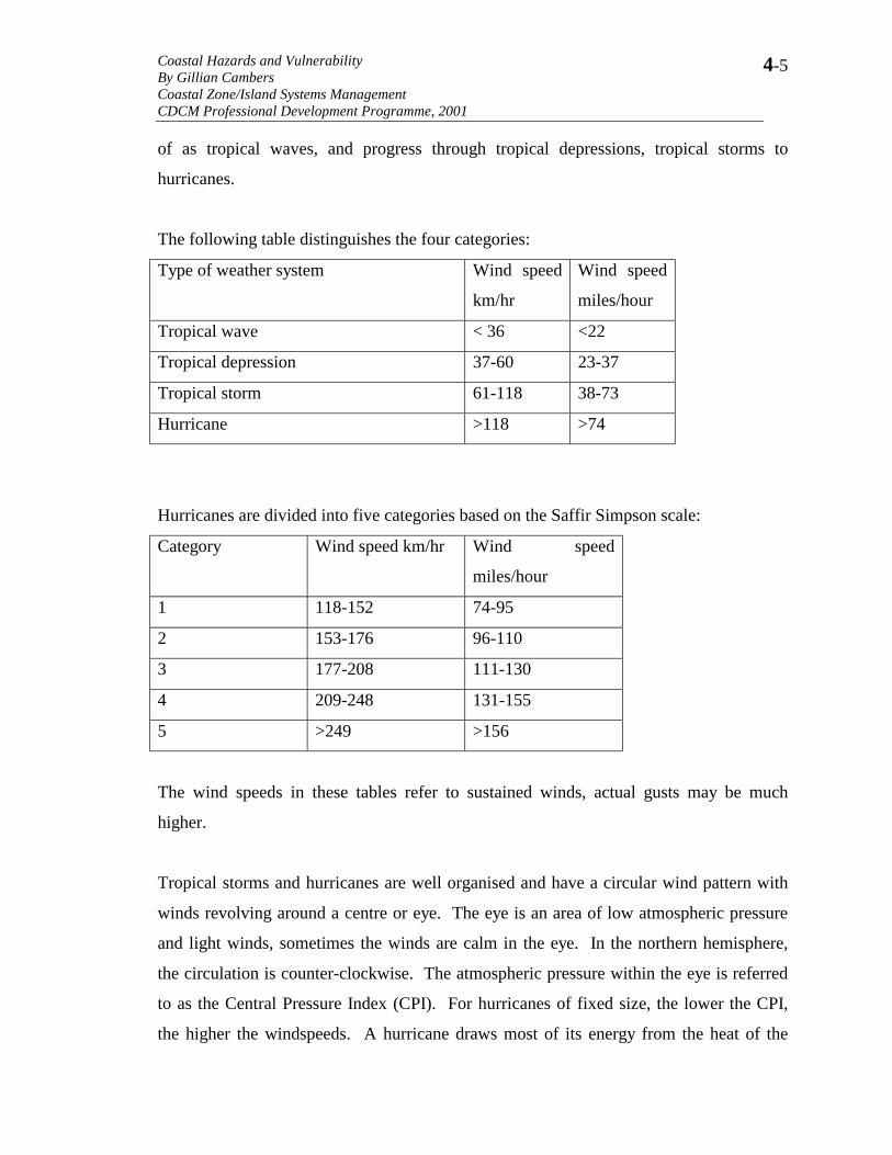
The following table distinguishes the four categories:
Type of weather system Wind speed
km/hr
Wind speed
miles/hour
Tropical wave < 36 <22
Tropical depression 37-60 23-37
Tropical storm 61-118 38-73
Hurricane >118 >74
Hurricanes are divided into five categories based on the Saffir Simpson scale:
Category Wind speed km/hr Wind speed
miles/hour
1 118-152 74-95
2 153-176 96-110
3 177-208 111-130
4 209-248 131-155
5 >249 >156
The wind speeds in these tables refer to sustained winds, actual gusts may be much
higher.
Tropical storms and hurricanes are well organised and have a circular wind pattern with
winds revolving around a centre or eye. The eye is an area of low atmospheric pressure
and light winds, sometimes the winds are calm in the eye. In the northern hemisphere,
the circulation is counter-clockwise. The atmospheric pressure within the eye is referred
to as the Central Pressure Index (CPI). For hurricanes of fixed size, the lower the CPI,
the higher the windspeeds. A hurricane draws most of its energy from the heat of the
Coastal Hazards and Vulnerability By Gillian Cambers Coastal Zone/Island Systems Management CDCM Professional Development Programme, 2001
4-6
ocean’s surface water, hence when they move over land, they often disintegrate and
dissipate.
Many hurricanes start as tropical waves off the west coast of Africa, and develop in
intensity as they move westwards. Figure 2 shows hurricane tracks in the Atlantic basin
between 1965 and 1995. In the Caribbean region, most hurricanes move west to
northwest; as they approach North America, they often adopt a more northerly track, and
may eventually turn northeast and dissipate in the North Atlantic Ocean, or move towards
Europe and North Africa.
Most, but not all, hurricanes in the Caribbean move from east to west. A hurricane may
be divided into four quadrants. The winds on the right side are often the strongest,
particularly the northeast quadrant. After the hurricane has passed a particular point, the
wind often reverses direction.
It is unwise to generalise with hurricanes, a hurricane may move in any direction. While
Figure 2 shows generalised tracks, many hurricanes move south or east for periods of
time. Each hurricane is individual in terms of size, speed of forward movement, pressure,
wind pattern and rainfall amounts, and this makes prediction of the precise impacts in the
local area, difficult.
Hurricane Lenny in November tested many ideas about hurricanes. This started as a
tropical system north of Colombia, it moved north towards Jamaica and then moved
steadily eastwards to Anguilla and St. Maarten, it then moved southeast towards
Dominica before moving out into the Atlantic Ocean and dissipating. This late season
hurricane, which moved in a very unusual west to east direction, heavily impacted the
west coasts of the Lesser Antilles causing extreme damage. It was also an extremely
intense hurricane, at times verging between categories 4 and 5. Its effects were felt
throughout the Caribbean region, and damage occurred in countries that traditionally
consider themselves ‘outside the hurricane belt’ like Trinidad and Tobago and Venezuela.
Coastal Hazards and Vulnerability By Gillian Cambers Coastal Zone/Island Systems Management CDCM Professional Development Programme, 2001
4-7
Internet sites with information about past hurricanes: There are several sites with
information about past hurricanes, including dates, storm characteristics, tracks etc., just
two sites are www.nhc.noaa.gov/ and www.weather.com but there are many more.
Increased frequency of Atlantic hurricanes since 1995: A team of researchers led by Dr.
William Grey working at Colorado State University have determined that there are cycles
of hurricane activity, with two to three decades of less hurricane activity followed by a
similar period of more intense hurricane activity. There are several factors causing the
cycles including rainfall amounts in the Sahel region of West Africa, upper level winds,
ocean temperatures, among others. They predict that since 1995 the Atlantic basin has
entered a more active hurricane cycle, which may extend through the early decades of
this century. This is of particular concern since coastal areas are now so intensely
developed, and people may have been lulled into a false sense of security by the decades
of the 1970s and 1980s, which were a period of less hurricane activity.
For people living in the eastern Caribbean islands, the increased frequency of hurricanes
since 1995 is evident. In 1995 three significant hurricane systems moved through the
area in a three-week period: Hurricanes Iris, Luis and Marilyn. In 1996, there was
Hurricane Hortense, in 1998 Hurricane Georges and in 1999 Hurricane Lenny, as well as
several other less serious hurricanes.
The following table, which has been derived from Dr. Grey’s website
(http://typhoon.atmos.colostate.edu/forecasts/1999/nov99/ provides a summary of the
hurricane frequency in the Atlantic basin during the period 1990-1994 and 1995-1999.
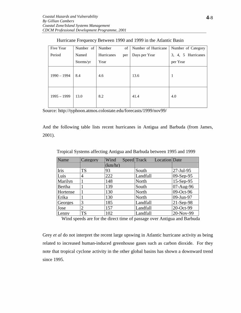
Coastal Hazards and Vulnerability By Gillian Cambers Coastal Zone/Island Systems Management CDCM Professional Development Programme, 2001
4-8
Hurricane Frequency Between 1990 and 1999 in the Atlantic Basin Five Year
Period
Number of
Named
Storms/yr
Number of
Hurricanes per
Year
Number of Hurricane
Days per Year
Number of Category
3, 4, 5 Hurricanes
per Year
1990 – 1994
8.4
4.6
13.6
1
1995 – 1999
13.0
8.2
41.4
4.0
Source: http://typhoon.atmos.colostate.edu/forecasts/1999/nov99/
And the following table lists recent hurricanes in Antigua and Barbuda (from James,
2001).
Tropical Systems affecting Antigua and Barbuda between 1995 and 1999
Name Category Wind Speed Track Location Date (km/hr) Iris TS 93 South 27-Jul-95 Luis 4 222 Landfall 09-Sep-95 Marilyn 1 148 North 15-Sep-95 Bertha 1 139 South 07-Aug-96 Hortense 1 130 North 09-Oct-96 Erika 1 130 North 09-Jun-97 Georges 3 185 Landfall 21-Sep-98 Jose 2 157 Landfall 20-Oct-99 Lenny TS 102 Landfall 20-Nov-99 Wind speeds are for the direct time of passage over Antigua and Barbuda
Grey et al do not interpret the recent large upswing in Atlantic hurricane activity as being
related to increased human-induced greenhouse gases such as carbon dioxide. For they
note that tropical cyclone activity in the other global basins has shown a downward trend
since 1995.

Coastal Hazards and Vulnerability By Gillian Cambers Coastal Zone/Island Systems Management CDCM Professional Development Programme, 2001
4-9
Impacts of tropical storms and hurricanes: The main impacts of tropical storms and
hurricanes are high winds, high waves, storm surges and heavy rainfall. The high winds
result in damage to coastal ecosystems e.g. forests, to buildings and infrastructure; the
waves result in beach and cliff erosion, damage to coral reefs, seagrass beds and
mangroves, and damage to coastal infrastructure; the storm surge increases the coastal
damage; and the heavy rainfall causes flooding – the most serious recent example of this
was seen from Hurricane Mitch in 1998 in Honduras when thousands of people were
killed as a result of heavy rainfall, flooding and landslides.
The high winds cause particular damage to buildings (roofs are especially vulnerable),
utility transmission lines, and especially trees and forests. After a hurricane has passed,
all the foliage may be stripped from the trees and vegetation, and many trees may have
fallen.
Waves generated by hurricanes are particularly destructive to beaches and dunes, coral
reefs and seagrass beds. The high waves superimposed on top of the raised water level
caused by the storm surge, result in serious erosion of beaches and the land behind the
beach or dune. It is important to realise that a country may experience hurricane waves
even if it is not directly hit by the hurricane. For instance, Hurricane David in 1979,
which struck Dominica and then moved northwest to the Dominican Republic, generated
waves which affected many islands of the Caribbean, including Aruba and the
Netherlands Antilles, despite their being many hundreds of miles away from the centre of
the hurricane.
Beach profiles have been measured on a regular basis in the islands of the eastern
Caribbean since the early 1990s (and since 1985 in some islands) within the framework
of a regional project entitled ‘Coast and Beach Stability in the Caribbean Islands

Coastal Hazards and Vulnerability By Gillian Cambers Coastal Zone/Island Systems Management CDCM Professional Development Programme, 2001
4-10
(COSALC)’2. This project has provided useful information about beach changes as well
as erosion and beach recovery during and following hurricanes, see also Cambers, 1997a.
The beach profile data were used to determine the retreat of the land behind the beach or
coastal dune resulting from Hurricane Luis in September 1995. The table on the next
page shows the results:
The detailed results and discussion can be found in Cambers, 1996. The data show quite
clearly that the nearer the island to the centre of the hurricane, the greater the erosion rate.
The erosion rate here refers to the retreat of the land (or dune) behind the beach, and this
is regarded as a ‘permanent’ loss, since while beaches often recover, the land or coastal
dune will take decades to recover, and may indeed never reform. These average figures
cover a considerable range, for instance, in Anguilla, at Meads Bay on the north coast,
the coastal dunes retreated 30 m during Hurricane Luis.
Island Distance to the centre of
Hurricane Luis (km)
Shoreline (land behind the
beach) retreat (m)
Barbuda 5 18
Anguilla 28 9
Antigua 40 5
St. Kitts 70 4
Nevis 90 5
Montserrat 90 4
Dominica 180 3
Beaches themselves nearly always experience considerable erosion during hurricanes.
During Hurricane Luis, the average beach size in seven islands decreased by 28%
2 This project has recently been renamed ‘Managing beaches and planning for coastline change, Caribbean islands’ it is supported by UNESCO on their platform for Environment and Development in Coastal Regions and Small Islands (CSI) and the University of Puerto Rico Sea Grant College Program.
Coastal Hazards and Vulnerability By Gillian Cambers Coastal Zone/Island Systems Management CDCM Professional Development Programme, 2001
4-11
(Cambers, 1996a). Thus the waves were able to reach roads and buildings that were tens
of metres away from the active wave impact zone before the hurricane. The following are
some observations relating to beaches impacted by hurricanes:
• Some beaches may be totally stripped of sand, leaving rock outcrops exposed, e.g.
Barnes Bay in Anguilla after Hurricane Luis (for photographs before and after,
see Cambers, 1998).
• Rocky ledges often consisting of beachrock may become exposed when they were
not evident before.
• Considerable quantities of beach sand will have been moved inland, and deposited
on coastal highways, in swimming pools and on beachfront properties.
• Large volumes of sand will have been moved offshore, and the water depth in the
offshore zone may be much shallower than before the hurricane.
• Sand dunes may have totally disappeared, or remnants may be left with a vertical
seaward slope and bereft of vegetation.
• In small sandy bays, all the sand may have been moved to one end of the beach.
• Beach material may have changed from sand to stones and boulders.
It should be noted that this list is not exhaustive. On rare occasions there may be no
change or even accretion at a particular beach. However, it should be noted that in two
islands monitored as part of the COSALC project, and where more than 30 beaches were
monitored in each island, only one beach in Antigua and one beach in Anguilla showed
accretion after the 1995 hurricanes.
While beaches show considerable damage during hurricanes, they do recover in the
following months. Monitoring after Hurricane Luis in 1995 showed an average 80%
recovery of beach volume eight months after the hurricane. However, not all beaches
show complete recovery after a hurricane. This was evident in Prince Rupert Bay in
Dominica after Hurricane Hugo in 1989. Several beaches did not recover to pre-
hurricane levels over a three-year period (Cambers and James, 1994). Indeed, when
profiles are compared from 1987 and 2000, there has been considerable and significant
Coastal Hazards and Vulnerability By Gillian Cambers Coastal Zone/Island Systems Management CDCM Professional Development Programme, 2001
4-12
loss at these beaches as a result of several hurricanes. Furthermore, at Toucarie and Belle
Hall, two beaches on the northwest coast of Dominica, which used to vary between sand
in the summer months and stones in the winter months, beach material now consists of
stones and boulders all year round, and thus the beaches have lost much of their
recreational value.
In addition, accretionary features, such as spits and tombolos, when impacted by
successive hurricanes, show major changes. In the two decades since Hurricane David
struck in 1979, the Scotts Head tombolo in Dominica has shown continuous lowering to
the point where it is now easily breached by a small storm. Similarly, in St. Kitts, since
Hurricanes David and Frederick in 1979, the Dieppe Bay spit on the northeast coast has
virtually disappeared.
Many of the islands in the northeast of the Caribbean have been impacted by several
hurricanes in the latter part of the 1990s. This appears to be resulting in a weakening of
the beach systems, such that even small storms now have a major impact. This
observation has yet to be quantitatively assessed.
Mitigating the impacts of hurricanes on beaches: The best way to conserve beaches is to
allow them the space to move, in a seaward direction during accretion phases, and in a
landwards direction during erosion phases. Ensuring that beachfront development is
placed a ‘safe’ distance behind the active beach zone, ensures that space is provided for a
beach to move naturally, both during normal events and infrequent hurricanes, thereby
ensuring the beach is conserved and coastal infrastructure remains intact. The ‘safe’
distance is referred to in planning terms as the ‘coastal development setback’. There are
various methods for calculating such distances, one recent one (Cambers, 1997b)
calculates a specific setback for each beach based on (i) erosional history (determined
from profile monitoring and aerial photographs), (ii) measured changes during the most
recent hurricane, (iii) predicted sea level rise and (iv) planning factors. This method is
currently being informally implemented in Anguilla and in St. Kitts and Nevis.
Coastal Hazards and Vulnerability By Gillian Cambers Coastal Zone/Island Systems Management CDCM Professional Development Programme, 2001
4-13
Coral reefs and seagrass beds: Tropical storms and hurricanes also impact these marine
ecosystems, although often the damage goes unseen and its effects may not become
apparent for several years. Coral reefs are important biological systems, in addition they
provide protection for beaches by acting as natural breakwaters, e.g. the Cobblers Reef, a
barrier reef off the southeast coast of Barbados provides a relatively sheltered wave
environment for the coastline. Coral reefs are also an important source of beach sand.
A quantitative survey was conducted of marine ecosystems and beaches in Anguilla in
1994, this was repeated in 1996, after Hurricane Luis which occurred in September, 1995
(Blair Myers et al, 1994, Bythell and Buchan 1996, Cambers, 1996b). The following
represents the highlights:
• Mortality rates of red, white and black mangroves varied between 68% and 99%.
Mortality rate of buttonwood mangroves was 49%.
• Seagrass bed cover was reduced by 45%, extensive carpets of dead seagrass up to
1 m thick were spread over many of the beaches.
• 61% of intact live reefs, either hard coral or soft corals, were degraded to rubble
or bare rock. Previously intact (though dead) elkhorn reefs were largely reduced
to rubble, thus their natural breakwater effect was lost.
• Beach volume had decreased by an average of 40% and beach width had
decreased by an average of 9 m. Two small cays, Scilly Cay and Sandy Cay were
totally stripped of sand, in fact Sandy Cay was not visible above the level of the
sea for sometime after the hurricane.
• The dune edge retreated an average of 9 m landward.
The heavy rains caused by tropical storms and hurricanes often result in serious flooding.
For instance, Anguilla is a limestone island, which has no rivers or streams because of the
porosity of the rock. As a result of the heavy rainfall during Hurricane Lenny in
November, 1999, the capital – The Valley, was flooded and a lake 4 m deep formed. The
extreme rainfall, channelled down to the coast through rivers and streams may wash away
entire beaches.
Coastal Hazards and Vulnerability By Gillian Cambers Coastal Zone/Island Systems Management CDCM Professional Development Programme, 2001
4-14
Impact on people’s lives: Tropical storms and hurricanes impact many aspects of people’s
lives, as well as natural ecosystems. This may range from the number of lost days due to
hurricanes for fishermen, for schools and businesses, to the serious impacts on the
tourism industry and the economic framework of the country. Not only are hotels and
other facilities closed for a considerable period after the hurricane, but publicity about the
event may deter potential tourists from visiting. Furthermore, hurricanes often occur in
September, only two months before the start up of the peak tourist season in mid-
December. The cost of recovery is also significant, particularly when a country
experiences several countries over a period of years, e.g. St. Maarten. There is also the
psychological effect on people.
Perception of hurricanes: It is significant to note that people’s attitudes are changing in
some parts of the Caribbean, particularly the northeastern islands of the Lesser Antilles,
no longer is it a case of ‘if a hurricane will hit this year’. Now it is ‘when will the
hurricane hit this year’.
Increasing vulnerability: As beachfront lands are being increasingly developed in
response to the needs of the tourism industry, and people’s desire to live by the shore, so
the vulnerability of these areas is increasing. This is of particular concern as predictions
indicate we are entering a period of increased hurricane activity.
Swell waves (non-hurricane): In this section mention has been made about hurricane
waves, their impact and the vulnerability of coastlines. However, it is important to
realise that hurricanes are not the only cause of high waves. Many exposed Caribbean
coasts, especially those facing east, experience high waves all year round. This is a result
of the Caribbean being situated in the Northeast Trade Wind Zone.
However, in addition to this, many Caribbean countries experience high waves in the
winter months (October to April) as a result of swell waves, which travel south from
intense mid-latitude storms in the North Atlantic Ocean. For instance, the weather events
Coastal Hazards and Vulnerability By Gillian Cambers Coastal Zone/Island Systems Management CDCM Professional Development Programme, 2001
4-15
described in the book and film ‘A Perfect Storm’ (Junger, 1997) resulted in swell waves,
which affected the eastern Caribbean islands. Such winter swell waves are particularly
serious on the west or leeward coasts of the Caribbean islands, these coasts normally are
sheltered and only experience very low waves. They are also the coasts where most of
the tourism infrastructure is located. Such swell events occur on average between 5 and
10 times a year, and each event may last for several days, with waves between 1 and 3 m,
although occasionally they may be as high as 5 m.
2. Storm Surges
A storm surge is the rapid rise in the water level surface produced by onshore hurricane
winds and falling barometric pressure.
Causes of storm surges: The low barometric pressure in a hurricane causes the sea
surface to rise. In the open ocean the rise of the sea surface is around 1-1.2 m maximum.
However, as the hurricane approaches the coast and shallow water, the rise in the water
level is amplified. The hurricane pushes a massive surge of seawater ahead of its eye,
this is capable of extensive damage when it hits the shore, this is especially the case in
continental countries, such as those in Central America and the U.S.A., with wide
continental shelves.
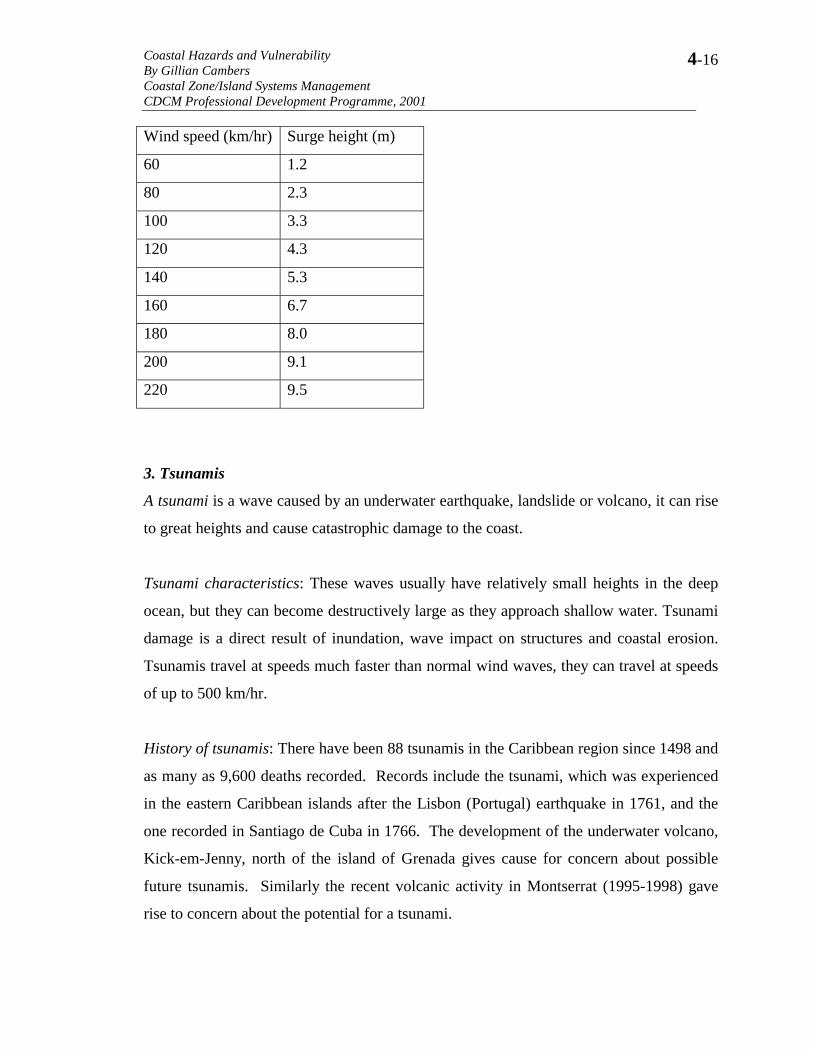
Surge heights: The table on the following page, which has been adapted from Clark 1996,
gives approximate surge heights for various windspeeds:
Further information about storm surges and predictions in St. Kitts and Nevis and
Antigua and Barbuda may be found at the web site for the Post Georges Disaster
Mitigation Project at www.oas.org/pgdm
Coastal Hazards and Vulnerability By Gillian Cambers Coastal Zone/Island Systems Management CDCM Professional Development Programme, 2001
4-16
Wind speed (km/hr) Surge height (m)
60 1.2
80 2.3
100 3.3
120 4.3
140 5.3
160 6.7
180 8.0
200 9.1
220 9.5
3. Tsunamis
A tsunami is a wave caused by an underwater earthquake, landslide or volcano, it can rise
to great heights and cause catastrophic damage to the coast.
Tsunami characteristics: These waves usually have relatively small heights in the deep
ocean, but they can become destructively large as they approach shallow water. Tsunami
damage is a direct result of inundation, wave impact on structures and coastal erosion.
Tsunamis travel at speeds much faster than normal wind waves, they can travel at speeds
of up to 500 km/hr.
History of tsunamis: There have been 88 tsunamis in the Caribbean region since 1498 and
as many as 9,600 deaths recorded. Records include the tsunami, which was experienced
in the eastern Caribbean islands after the Lisbon (Portugal) earthquake in 1761, and the
one recorded in Santiago de Cuba in 1766. The development of the underwater volcano,
Kick-em-Jenny, north of the island of Grenada gives cause for concern about possible
future tsunamis. Similarly the recent volcanic activity in Montserrat (1995-1998) gave
rise to concern about the potential for a tsunami.
Coastal Hazards and Vulnerability By Gillian Cambers Coastal Zone/Island Systems Management CDCM Professional Development Programme, 2001
4-17
Tsunami warning system: There is an extensive tsunami warning system in the Pacific
Ocean, which provides warnings to countries throughout the Pacific. However, there is
no similar warning system in the Caribbean region, although plans for a warning system
are being discussed by the Intergovernmental Oceanographic Commission of UNESCO,
together with the Organization of American States and the University of Puerto Rico,
among others. Part of the problem in the Caribbean is that because of the relatively small
size of the region, warning times after a major earthquake, or seismic disturbance will be
relatively short.
4. Flooding
Flooding is not a specific coastal hazard, it can affect any part of a country. Nor is
flooding limited to specific events such as tropical storms and hurricanes. Heavy rain
associated with more frequent weather systems may cause flash floods and other weather
systems, e.g. the flooding and flash floods which occurred during the first week of May,
2001 in Puerto Rico were associated with a frontal system moving east from the Gulf of
Mexico.
5. Landslides
Landslides again are not necessarily a coastal phenomenon, although they do often occur
at the coast as a result of the often steep, unstable slopes and cliffs, which are often
impacted and undercut by wave action.
6. Volcanic Eruptions
When these occur, they are likely to affect a large area, as was the case with the eruption
of Castle Peak in Montserrat between 1995 and 1998. The southern two thirds of the
island was devastated by the volcanic eruption, and the entire topography changed. Some
beaches, such as Iles Bay, near the outlet of a major pyroclastic flow at the Belham
Coastal Hazards and Vulnerability By Gillian Cambers Coastal Zone/Island Systems Management CDCM Professional Development Programme, 2001
4-18
valley, and Sturge Park, north of the abandoned town of Plymouth, have expanded in
width by 50-100 metres as a result of the material accumulated from the volcanic
eruptions.
7. Earthquakes
Again earthquakes are not limited to coastal areas.
An earthquake is a sudden motion of the earth caused by an abrupt release of slowly
accumulating stress.
Earthquake magnitude is measured on the Richter scale, which is a logarithmic scale
expressing the magnitude of the earthquake in terms of the energy dissipated.
Causes of earthquakes: The main archipelago of Caribbean islands formed along the area
where the American Plate is being subducted beneath the thicker Caribbean Plate. The
instability produced at these plate margins is not only responsible for active volcanism
and magma implacement at shallow depths in the region, but also for regional and
sometimes localised fracturing and faulting, producing earthquakes. Thus earthquakes are
common in the plate margins. For instance Puerto Rico has an average of 30 earth
tremors every month.
Coastal Hazards and Vulnerability By Gillian Cambers Coastal Zone/Island Systems Management CDCM Professional Development Programme, 2001
4-19
REFERENCES AND READING MATERIAL Blair Myers, C., Matheson, K., Sheppard, C.R., Bythell, J.C. 1994. A coastal resource atlas of Anguilla, British West Indies. Natural Resources Institute, U.K. Overseas Development Administration. 12, 1:10,000 sheets. Bythell, J.C., Buchan, K.C. 1996. Impact of Hurricane Luis on the coastal and marine resources of Anguilla: Marine ecological survey. British Development Division in the Caribbean. 18 pp. Bythell, J.C., Cambers, G., Hendry, M.D. 1996. Impact of Hurricane Luis on the coastal and marine resources of Anguilla. U.K. Dependent Territories Regional Secretariat, 13 pp. Cambers, G. 1996a. Hurricane impacts on beaches in the eastern Caribbean islands. Coast and Beach Stability in the Lesser Antilles (COSALC) report. 96 pp. Cambers, G. 1996b. Impact of Hurricane Luis on the coastal and marine resources of Anguilla: Beach resources survey. British Development Division in the Caribbean. 92 pp. Cambers, G. 1997a. Beach changes in the eastern Caribbean islands: hurricane impacts and implications for climate change. In Journal of Coastal Research, Special Issue # 24, ‘Island states at risk: global climate change, development and population.29-48 pp. Cambers, G. 1997b. Planning for coastline change: Guidelines for construction setbacks in the eastern Caribbean islands. UNESCO info 4. 14 pp. Cambers, G. 1998. Coping with beach erosion. Coastal Management Source Books 1. UNESCO Publishing. 119 pp. Cambers, G., James, A. 1994. Sandy coast monitoring: the Dominica example (1987-1992). UNESCO reports in Marine Sciences, No. 63, 91 pp. Clark, J.R. 1996. Coastal Zone Management Handbook. CRC Lewis. 694 pp. Coastal Zone Management Sub-Group. 1992. Global climate change and the rising challenge of the sea. Intergovernmental Panel on Climate Change Response Strategies Working Group, published by Directorate General Rijkswaterstaat, Netherlands, 35 pages + appendices. Grey, W. (http://typhoon.atmos.colostate.edu/forecasts/1999/nov99/ James, P. 2001.An assessment of coastal erosion hazards in Antigua and Barbuda. Report prepared for the Post-Georges Disaster Mitigation project in Antigua and Barbuda
Coastal Hazards and Vulnerability By Gillian Cambers Coastal Zone/Island Systems Management CDCM Professional Development Programme, 2001
4-20
and St. Kitts-Nevis, Organization of American States and US AID. (See also www.oas.org/pgdm) Junger, S. 1997. The perfect storm. Published by W.W. Norton and Company Inc., 227 pp. Leatherman, S. 1997. (Ed.) ‘Island states at risk: global climate change, development and population. Journal of Coastal Research, Special Issue # 24, 242 pp. Post Georges Disaster Mitigation project www.oas.org/pgdm Sorenson, J.C., McCreary, S.T. 1990. Institutional arrangements for managing coastal resources and environments, Coastal Management Publication No. 1, NPS/US AID Series, National Park Service, Office of International Affairs, Washington, D.C. 194 pp.