coastal planning information package - environment.sa.gov.au · contents purpose of the coastal...
TRANSCRIPT

Coastal Planning Information PackageA guide to coastal development assessment and planning policyRevised November 2013


ContentsPurpose of the Coastal Planning Information Package 5
Coast Protection Board 6Coast Protection Board Policy 6
Membership of the Board 7
Coast Protection Board Contact Details 7
Department of Environment, Water and Natural Resources (DEWNR) 8Coastal Planning Officers 8 Coastal Scientific and Engineering Officers 9
Development Assessment on Coastal Land 10What coastal works constitute development? 10
Referrals to the Coast Protection Board 10
What is the Definition of Coastal Land? 10
What forms of development on coastal land do not require referral to the Coast Protection Board? 11
What does the planning authority have to do with comments received from a referral to the Coast Protection Board? 12
Forwarding the Decision Notification 12
What information should be provided by applicants for development on Coastal Land? 12
What information may planning authorities ask for? 13
Where are coastal issues covered in Development Plans? 13
What do the Development Plan’s coastal provisions address? 14
Planning Policy – Addressing Coastal Issues 20What policy should be contained within Development Plans regarding coast and marine issues? 20
What are appropriate Council Wide provisions? 20
Why establish coastal zones? 20
What should be included in coastal zones? 21
Which coastal zone should be chosen? 22
What forms of development are appropriate in coastal zones? 24
Why are sensitive coastal features and habitats important? 24
What hazards affect coastal areas? 26
What are the implications of climate change 29
What other issues should be addressed by planning policy? 31
Frequently Asked Questions 35
Coast Protection Board Referral Checklist 37
Information Requirements – Development on Coastal Land Checklist 38
Coastal Planning Policy Checklist 39
Coastal Planning Information Package 3

4 Coastal Planning Information Package

The package aims to raise awareness about the role and responsibilities of the Coast Protection Board, which is the statutory authority responsible for the State’s coast and administering the Coast Protection Act 1972, and the role that it has in development assessment in accord with the Development Act 1993. The package also seeks to explain existing Development Plan coastal policy and aid the preparation and review of planning policy relating to coastal issues.
In particular, the package has been prepared to assist planners, and planning authorities and their officers, with the assessment of development applications on coastal land and the preparation of coastal and marine related planning policy.
The package can also assist applicants in preparing a development application for a proposal on coastal land.
The information contained in the package can be used to:
• determine whether a proposed development site is on ‘coastal land’ and therefore whether a referral to the Coast Protection Board is required;
• assist with the assessment of a development application which is on ‘coastal land’;
• identify what information should be provided with the development application;
• prepare planning policy about coastal issues.
Purpose of the Coastal Planning Information Package
Coastal Planning Information Package 5

The Coast Protection Board was established by the Coast Protection Act 1972 and is the statutory body in South Australia that manages coast and marine protection issues and provides advice on coastal development. The Coast Protection Act:
• defines the powers of the Board (Part 4); and
• defines the functions of the Board (Section 14).
See the Act at: www.legislation.sa.gov.au/LZ/C/A/COAST
The key functions of the Coast Protection Board include:
• protecting and restoring the coast;
• developing the coast for aesthetic and other purposes;
• providing advice to the relevant Minister;
• undertaking research regarding the protection, restoration or development of the coast; and
• providing advice on development application referrals in accordance with its responsibilities under the Development Act 1993, the Coast Protection Act 1972 and Coast Protection Board policy.
The Coast Protection Board is a referral body under Schedule 8 of the Development Regulations 2008 for development applications on ‘coastal land’. Almost all responses are provided under delegated authority, in accordance with Board policy, by officers of the Department of Environment, Water and Natural Resources (DEWNR). The Department provides technical and administrative assistance to the Board.
Matters where the applicability of Board policy is uncertain, or matters which are the subject of significant public debate, will go to a meeting of the Board for determination.
Coast Protection Board PolicyThe Coast Protection Board’s policy can be viewed at: www.environment.sa.gov.au/Conservation/Coastal_Marine/Coast_Protection_Board/Policies_strategic_plans
The policies address a number of key areas including:
• development in the coastal zone;
• hazards - including coastal flooding and erosion;
• protection works;
• conservation of coast and marine habitats, including coastal wetlands, rivers and estuaries;
• heritage and landscape;
• access to the coast;
• standards applying to new development with regard to coastal flooding and erosion and associated protection works; and
• acid sulfate soil development guidelines and risk assessment criteria.
The Board is also required to take into account, and seek to further, the objects and objectives of the Adelaide Dolphin Sanctuary Act 2005, the River Murray Act 2003 and the Marine Parks Act 2007.
Coast Protection Board
6 Coastal Planning Information Package

Membership of the BoardThe Coast Protection Act 1972 prescribes that the Board is comprised of 6 members. Currently:
• one is a nominee of the Chief Executive of the Department of Environment, Water and Natural Resources;
• one is a nominee of the Chief Executive of the Department of Planning, Transport and Infrastructure; and
• one is a nominee of the Chief Executive of the South Australian Tourism Commission
Three members are appointed by the Governor of whom:
• One will have knowledge of and experience in local government;
• One will have knowledge of and experience in biological sciences and environmental protection;
• One will have knowledge of and experience in the technical problems of coast protection;
In addition, meetings of the Board are attended by:
• Two Local Government Advisory Committee members; and
• A Metropolitan Seaside Councils Committee member
Coast Protection Board Contact Details
Postal address:
Business Support Officer Coast Protection Board GPO Box 1047 ADELAIDE SA 5001
Location:
1 Richmond Road, Keswick SA
Telephone:
Margaret Phillips – Business Support Officer: 08 8124 4928
Fax:
08 8124 4920
Website:
www.environment.sa.gov.au/Conservation/Coastal_marine/Coast_Protection_Board
Note:
Local Councils and the Development Assessment Commission can email development applications and decision notification forms to: DEWNR.CoastProtectionBoard [email protected]
Coastal Planning Information Package 7

Department of Environment, Water and Natural Resources (DEWNR)
The Department provides a support role in the management and protection of coastal environments and assets across South Australia. It also provides technical and administrative assistance to the Coast Protection Board.
The Department’s coastal planning officers:
• provide advice on coast and marine planning issues;
• process the development applications referred to the Coast Protection Board; and
• provide coast and marine input into planning policy, including the State’s Planning Strategy, Section 30 Council Development Plan Reviews, Statements of Intent and Plan Amendment Reports.
DEWNR Coastal Planning OfficersSenior Planner (Planning, Strategy, Development Plan reviews and amendments) Tony Huppatz Phone: 08 8124 4885 Email: [email protected]
Planning Officer (Board responses to development applications : Yorke Peninsula) Arron Broom Phone: 08 8124 4929 Email: [email protected]
Planning Officer (Board responses to development applications: remainder of state’s coast) Peter Allen Phone: 08 8124 4906 Email: [email protected]
Postal address: GPO Box 1047 ADELAIDE South Australia 5001
Office Location: 1 Richmond Road KESWICK South Australia 5035
Telephone 08 8124 4705 Facsimile 08 8124 4920
8 Coastal Planning Information Package

Coastal Scientific and Engineering OfficersThe Board’s responses are further supported by DEWNR technical input led by Scientific Officers operating in each of the coastal regions.
The technical input includes that provided by:
Engineers (expertise in coastal engineering, protection works and strategies, and physical processes).
Scientific Officers (expertise in coastal habitat, vegetation and landforms, beach monitoring, coastal acid sulfate soils).
Marine Biologists (expertise in marine biology, mammals, habitat and vegetation).
Marine Parks officers (establishing a representative system of marine protected areas).
Adelaide Dolphin Sanctuary Officers (provide advice in regards to the sanctuary which has been established in and around the Port River).
Public Land officers (crown land tenure issues).
DEWNR Information Available to Assist Planning Authorities and ApplicantsDEWNR also has a range of information and resources on coast and marine issues available to planning authorities which can assist with the development assessment and planning policy preparation process, including:
• Living Coast Strategy – see Related Links at: http://www.environment.sa.gov.au/our-places/coasts
• NatureMaps provides a range of information about coastal areas including oblique photographs, saltmarsh/mangrove areas, coastal acid sulfate soils, beach profile lines, aerial photographs and zoning details: www.naturemaps.sa.gov.au/
• Coast Protection Board Strategic Plan and policies: www.environment.sa.gov.au/about-us/boards-and-committees/Coast_Protection_Board/Policies_strategic_plans
• Coastal Viewscapes Report and Maps – see Coastal Viewscapes Project at: www.environment.sa.gov.au/our-places/coasts/Adelaides_Living_Beaches/Resources
• Adelaide Living Beaches Program: www.environment.sa.gov.au/our-places/coasts/Adelaides_Living_Beaches
• Coastal Acid Sulfate Soils See other reference material at: www.environment.sa.gov.au/our-places/coasts/Adelaides_Living_Beaches/Resources
• Coastal weeds, seagrasses, and beach monitoring – see list at: www.environment.sa.gov.au/our-places/coasts/Adelaides_Living_Beaches/Resources
NatureMaps
Coastal Planning Information Package 9

Development Assessment on Coastal Land
What coastal works constitute development?The Development Regulations include Schedules which provide further guidance to what is and isn’t development. Schedule 2 prescribes Additional acts and activities constituting development and Schedule 3 prescribes acts and activities which are not development.
Some works which may not otherwise require development approval do, together with referral to the Coast Protection Board, because of their proximity or connection to the coast.
That includes, for example, certain excavation and filling (see part 5 of Schedule 2), certain coast protection works (see part 6 of Schedule 2), and certain Class 10 non-habitable buildings outside of council areas (see part 9(e) of Schedule 3).
It also includes certain Council works such as a new drain or pipe, recreational buildings and coast protection works within 100 metres of the coast (see part 2 of Schedule 3).
However other coastal works are also included in those provisions and the Schedules should be checked.
Schedule 14 also determines that certain State agency development does not require development approval. However some of those exemptions are subject to coastal criteria, including some which depend on the prior authorisation of the Coast Protection Board.
For the up-to-date detail of these Schedules, please refer to: www.legislation.sa.gov.au/
Referrals to the Coast Protection BoardSection 37 of the Development Act 1993, describes requirements for planning authorities to refer development applications. Regulation 24 and Schedule 8 of the Development Regulations 2008 detail the processes involved in such referrals. Schedule 8 defines the Coast Protection Board as a referral body for development on ‘coastal land’. Therefore, when assessing a development application, planning authorities must first determine whether the proposed development is on coastal land. If that is the case, and the development is not subject to the listed exclusions, it must refer the application to the Coast Protection Board.
What is the Definition of Coastal Land?‘Coastal land’ is:
(a) land situated in a zone or area defined in the relevant Development Plan where the name of the zone or area includes the word “Coast” or “Coastal”, or which indicates or suggests in some other way that the zone or area is situated on the coast;
(b) where paragraph (a) does not apply:
land that is situated in an area that, in the opinion of the relevant authority, comprises a township or an urban area and that is within 100 metres of the coast measured from mean high water mark on the sea shore at spring tide; or ..’
land that is situated in an area that, in the opinion of the relevant authority, comprises rural land and that is within 500 metres landward of the coast from mean high water mark on the sea shore at spring tide;
if there is no zone or area of a kind referred to in paragraph (a) between the land and the coast;’
(c) an area three nautical miles seaward of the mean high water mark on the sea shore at spring tide’
10 Coastal Planning Information Package

What forms of development on coastal land do not require referral to the Coast Protection Board?Schedule 8 of the Development Regulations 2008 determines that the following forms of development on ‘coastal land’ do not require referral:
(a) development that comprises the construction or alteration of, or addition to, a farm building; or
(b) development that in the opinion of the relevant authority is of a minor nature and comprises:
(i) the alteration of an existing building; or
(ii) he construction of a building to facilitate the use of an existing building; or
(c) complying development in respect of the relevant Development Plan, other than if the development is complying development under Schedule 4 clause 2B; or
(d) development within a River Murray Protection Area under the River Murray Act 2003 (such development is generally required to be referred to the Minister for the River Murray).
The Coastal Land Referral Checklist can be used to determine whether the proposed development is on coastal land. (See ‘Coastal Land Checklist’ on page 38 )
Cst
Scenario (a)Designated Coastal Zone or Area
inlandseaward
100mseaward
Scenario (b)(i)100 metres into a recognised* urban or township area
inland
Scenario (b)(ii)500 metres into recognised* rural land
500m
seaward inland
3 nautical miles
Scenario (c)3 nautical miles to sea, applies in all cases and is added to the areas indicated in scenarios (a),(b)(i) and (b)(ii)
inlandseaward
Coastal Planning Information Package 11

What does the planning authority have to do with comments received from a referral to the Coast Protection Board?In accordance with Schedule 8 of the Development Regulations 2008, for most proposed developments that are referred to the Coast Protection Board, planning authorities must have regard to any comments made about the proposal. In some cases, however, the Board has the power to direct the planning authority to refuse or impose conditions on the proposed development.
The planning authority is subject to the direction of the Coast Protection Board if the proposed development involves:
• excavating and/or filling more than 9 cubic metres (Click here to go to ‘Frequently Asked Questions’) of land within 100 metres landward or three nautical miles seaward of the coast measured from the mean high water mark on the seashore at spring tide;
• construction of coastal protection works within 100 metres landward or one kilometre seaward of the coast measured from the mean high water mark on the seashore at spring tide.
Schedule 8 of the Development Regulations determines that:
Direction means that the prescribed body may direct the relevant authority-
(a) to refuse the relevant application; or
(b) if the relevant authority decides to consent to or approve the development (subject to any other Act) to impose such conditions as the prescribed body thinks fit,
(and that the relevant authority must comply with any such direction).
In all other cases where development is proposed on coastal land and requires referral to the Coast Protection Board, the planning authority cannot consent to or approve a development without having regard to the Board’s comments.
Forwarding the Decision Notification It is a statutory requirement that the planning authority forwards a copy of the Decision Notification to the Coast Protection Board once the development application has been determined. This should be undertaken within 5 business days from when the notice is given to the applicant (see Regulation 43(2)).
Regular audits of planning authorities’ uptake of the Board advice are conducted.
What information should be provided by applicants for development on Coastal Land?It is important that an appropriate level of information is provided with a development application to enable the Coast Protection Board to do a complete assessment and provide a quick response to the planning authority.
Schedule 5 of the Development Regulations 2008 identifies what information must be provided with a development application. The Planning SA “Guide for Applications–All Applications” provides a checklist for other information that should be provided with a development application (www.sa.gov.au/upload/franchise/Housing,%20property%20and%20land/PLG/Development_applications_guide_to_applicants.pdf).
Clause 2 of Schedule 5 identifies additional information requirements that should be provided by an application for development near the coast. That Schedule is currently being updated.
Applications for development on coastal land should include where relevant:
(a) A copy of the relevant Development Plan Zone Map with the site marked by a cross;
(b) A plan showing, in addition to the normal building plan requirements of Clause 1 in Schedule 5:
• the location of Mean High Water Mark and the distance from it to the boundary of the site, any proposed buildings, and any proposed excavation or filling of land; and
• if any part of the site is less than or equal to 5 metres in elevation above Mean High Water Mark, the existing and finished site and floor levels to the Australian Height Datum (AHD); and
• the extent and volume of any filling or excavation; and
• any significant topographical feature including cliffs, sand dunes, saltmarsh and mangroves; and
• details of any proposed fencing and vehicle and pedestrian access ways; and
• details of vegetation to be retained or planted on, or removed from, the site; and
12 Coastal Planning Information Package

(c) Photographs:
(i) of the site taken from a point immediately seaward of the site; and
(ii) taken in the direction of the site from the closest point on the Mean High Water Mark to the site; and
(iii) taken at the same point described in part (ii) in both directions along the Mean High Water Mark;
(d) If any part of the site is less than or equal to 5 metres above Mean High Water Mark, elevations showing levels to Australian Height Datum (AHD);
(e) Details of any proposed effluent or stormwater management;
(f) Details of any coastal protection strategy for the site or its locality. If site or floor levels are proposed to address the Year 2050 requirement, the reasonable practical means to address sea level rise to the year 2100 (see page 15 – ‘Hazard Risk Minimisation and Erosion Buffers – flooding and erosion’);
(g) If the site is sub-tidal, a detailed benthic survey (see Frequently Asked Questions) of the sea floor;
(h) If the site is an area identified as being at risk from Coastal Acid Sulfate Soils;
(i) specific site and watertable levels, relative to Australian Height Datum (AHD);
(ii) soil and water sampling and analyses to determine presence of coastal acid sulfate soils contamination; and
(iii) where Coastal Acid Sulfate Soils are confirmed, additional information on remedial strategies to minimise surface and ground water contamination, and a management plan for ongoing monitoring and best practice management of the area.
Note: applications for development on land subject to the risk of coastal acid sulfate soils should accord with the Board Policy See ‘Other reference material at: www.environment.sa.gov.au/our-places/coasts/Adelaides_Living_Beaches/Resources
The Information Requirements – Development on Coastal Land Checklist can be used to determine whether the proposed development is on coastal land. (Click here for link to Development on Coastal Land Checklist).
What information may planning authorities ask for?Section 39 of the Development Act 1993 permits planning authorities to request additional documents or information reasonably required to assess a development application. Development on coastal land may require additional technical information that is not normally required to assess a development application. Therefore, planners should request such information which will assist them to make an appropriate planning decision and assist the Coast Protection Board to provide a full and quick response. The Coast Protection Board, as with other referral agencies, may also request further information in accordance with Section 37(2)(a) of the Development Act. The Board will inform the planning authority of that request.
Where are coastal issues covered in Development Plans?In 1994, the planning Minister amended Development Plans by way of the Regional Coastal Areas Policies Amendment. This amendment provided a comprehensive set of Development Plan policies regarding coastal issues which were in accord with State Government and Coast Protection Board Policy. Those policies were mostly contained under the ‘Coastal Areas’ heading in the Council Wide portion of Development Plans.
These provisions formed the basis of the coastal areas provisions in the South Australian Planning Policy Library: www.sa.gov.au/subject/Housing
Coastal Planning Information Package 13
What do the Development Plan’s coastal provisions address?
Environmental ProtectionThe coastal areas of the State are important for their onshore and marine environmental and landscape values, as well as for developed uses such as towns, holiday settlements, tourism, marinas, commercial farming, aquaculture and recreation. Development a considerable distance from the coast can affect all these areas if it influences the environment, general character and amenity of the coastal area or interferes with coastal processes such as erosion, tide and storm flooding or sand drift.
The coast is subjected to the forces of waves, tides and sea-currents, particularly during storms. ‘Soft’ coasts develop a balance between the sea and the land which changes with the seasons, a so called dynamic equilibrium. For example, beach and sand dunes built up during months of relative calm will be eroded during stormy seasons, only to be built up again after the storms have passed. As well, wave action and currents are continually moving sand along the shore, often resulting in a net drift of material in one direction. Development can directly or indirectly interfere with these processes by, for example, changing surface and ground-water flows and result in permanent loss of beach and dunes.
Not only may the shore environment be degraded and the amenity and recreation use of the beach be lost, but the development which caused the problem may become at risk. Even though there are policies to avoid public funding for protection of private development, public costs are often incurred on emergency works and protection of affected public land. The protection measures themselves (eg sea walls) often cause further loss of the beach and detract from public enjoyment of the coast.
In other areas coastal processes may be naturally eroding soft cliffs. Development located too close to such cliffs is not only at risk but could aggravate the erosion through increased stormwater run-off if it is of poor design. Sea cliffs can also provide valuable geological exposures.
The interface between sea and land is a very active area for the movement of water and sand or other matter. It is usually very rich in plants and animals, both marine and terrestrial and is an important breeding ground for many species. Such a biologically diverse environment is important in sustaining the biological resource base, particularly of the sea. Areas of conservation significance should be protected from development and zoned accordingly. If necessary the conservation effectiveness of coastal areas can be enhanced by linking them to other natural environments with linear parks.
The coast is continually at risk of being badly polluted as it is at the receiving end of land drainage systems. Experience has shown that this poses a significant risk to marine life and sea-food resources. Land based animals and people who eat contaminated sea-food also suffer. Wetlands, which are often found behind sand dunes, and tidal flats not only provide a rich wildlife habitat, and are known to be a valuable natural treatment area for organic matter carried by rivers.
Coastal habitats that are tide-dependent, such as mangroves and saltmarshes, will need to be able to migrate with rising sea levels. Where flood levees or other infrastructure such as roads prevent this, these habitats will be lost. As these are important fish nursery areas, secondary impacts can be expected.
The metropolitan coast is an environmental and recreational asset of prime importance to the quality of life in Adelaide. Most of the easily accessible coastal frontage has been developed and, generally the recreational value has always been recognised and therefore pedestrian accessibility has been maintained. However, the open space character has not, and coastal processes have been interfered with, particularly between Moana and Outer Harbour. As well, pollution from rivers, creeks and drains is damaging the marine environment in many places along the metropolitan coast.
Maintenance of Public AccessSince the first surveys the South Australian coast has been seen as a public resource for the enjoyment of all. It is important that public access to the coast, particularly to beaches, is maintained and improved in a way that is consistent with the other objectives. It is essential that development does not preclude or restrict public access along the coast and that conservation and public reserves are not damaged or alienated by the location or design of abutting development. Where necessary, areas important to public recreation in coastal areas should be zoned accordingly. Unless capable of a dual purpose, conservation reserves should not be used for public access purposes, nor should they be regarded as expendable-erosion protection areas.
Spur roads to the coast and lookouts are favoured over esplanades as they usually have less impact on coastal environment. In environmentally suitable parts of coastal areas away from the coast, it may be possible to use loop roads to allow visitors to arrive and depart by different routes.
The Metropolitan beaches and inshore waters are a primary recreation area for Adelaide and an important element of the Metropolitan Adelaide Open Space System.
14 Coastal Planning Information Package

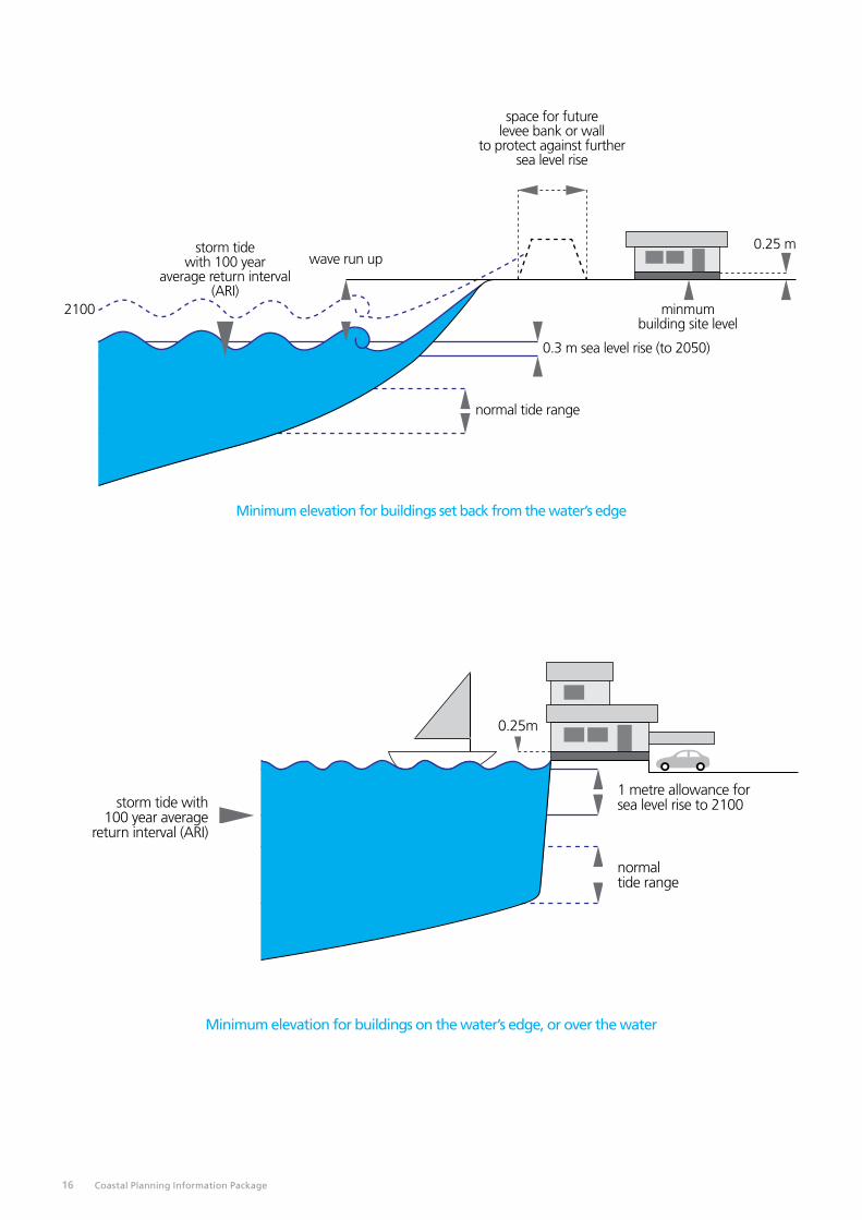
Hazard Risk Minimisation and Erosion Buffers – flooding and erosionThe Coastal Areas Hazard Risk Minimisation provisions require a technical assessment to ensure that the coastal flooding and erosion risk is properly addressed for the specific location of the proposed development. The applicant may provide a consultant’s expert assessment. The Board will also provide an assessment in its response to the applications referred to it.
Information assisting in the interpretation of the hazard risk minimisation provisions is found in Appendix 1` of the Coast Protection Board Policy and the Policy on coast protection and new coastal development (1991) at: www.environment.sa.gov.au/about-us/boards-and-committees/Coast_Protection_Board/Policies_strategic_plans
See also the Coast Protection Board’s Coastline 26 (Coastal erosion, flooding and sea level rise standards and protection policy) Other reference material at: www.environment.sa.gov.au/our-places/coasts/Adelaides_Living_Beaches/Resources
Low lying land which is now or in the future, subject to inundation by storm tides or stormwater should not be developed unless environmentally sound mitigation and protection works are formally and securely guaranteed by the council or the proponents of development.
In regards to flooding, minimum site levels are determined by using the 100 year average recurrence interval (ARI) seawater level for the particular location, additional allowances for wave effects and land subsidence where relevant, and the sea level rises discussed below. A freeboard for floor levels above the minimum site level of at least 0.25m is also required (see examples below).
Subsidence is a common problem in coastal areas. Rates of subsidence are significant in some places, especially in low-Iying areas where soft sediments may still be compacting.
Minimum levels may also need to take account of stormwater retention caused by elevated sea water levels or flood control measures.
The flooding and erosion protection requirements are based on an allowance for sea-level rise due to global climate change of 0.3 m between 1991 and 2050. Development should also be capable of being protected against a further sea-level rise, and associated erosion, of 0.7 m between 2050 and 2100.
For residential development within existing low-lying vulnerable settlements, elevated floor levels may be considered as an alternative option to raising site levels provided adjacent land and buildings are uniformly low lying, and where the integrity of adjacent land and buildings will be not be compromised if the site of the development is inundated (e.g. by scouring as a result of site inundation). This may include such settlements as Cowleds Landing, Chinaman Wells, and Foul Bay.
Furthermore, elevated floor levels may be considered as an alternative to raising site levels provided the following criteria is met:
• The finished floor level is no lower than a height determined by adding 1.25m to the 100 year ARI water level and making adjustment (if appropriate) for land subsidence or uplift to the year 2050.
• Underside areas are not enclosed (to allow for the potential flow through of water whilst supporting the house above).
• Service facilities vulnerable to flooding are raised above the finished floor level (i.e. electrical power outlets, switchboards, hot water systems, air conditioning units, water pumps etc).
The application of this alternative option (i.e. raising floor levels only) recognises that such existing settlements are perhaps in inappropriate locations in regards to coastal hazards, and that elevated floor levels do not alleviate long term coastal hazard risks, nor does it lessen the requirement for whole of settlement coastal hazard adaptation strategies. New settlement should either avoid such hazards or address the more substantial site and floor level protection requirements by the other standards.
Levee breach, Gillman 1994
Coastal Planning Information Package 15
space for future levee bank or wall
to protect against further sea level rise
storm tide with 100 year
average return interval (ARI)
wave run up0.25 m
minmum building site level
0.3 m sea level rise (to 2050)
normal tide range
2100
Minimum elevation for buildings set back from the water’s edge
Minimum elevation for buildings on the water’s edge, or over the water
storm tide with 100 year average
return interval (ARI)
normal tide range
1 metre allowance for sea level rise to 2100
0.25m
16 Coastal Planning Information Package

The use of devices such as levees, flood gates, valves, or stormwater pumping to provide protection for site levels lower than those determined using the principles outlined above creates additional risks associated with failure of the devices. Failure could be caused by inappropriate maintenance, poor construction, or occurrence of a storm surge event greater than the design event. The impacts of hurricane Katrina on New Orleans in 2005 provide one example of the risks associated with relying upon levees for flood protection: en.wikipedia.org/wiki/Effects_of_Hurricane_Katrina_in_ New_Orleans
Coastal erosion around the South Australian coast is, in many places, quite active resulting in significant coastal recession. Accelerated sea level rise will generally cause an increase in the rate of recession, although the interaction with local coastal processes can be complex.
The recession/erosion standards are similar to the flooding standards in that they require development to be safe from the effects of a 0.3m sea level rise and to be capable of being protected against additional recession due to a further 0.7m of rise.
If the coast is retreating, the foreshore, dunes, and wetlands contained in any coastal reserve could retreat also, unless they are prevented by natural or man-made features. Hence any erosion buffer should be additional to the coastal reserve.
Erosion mitigation works should only be considered in those instances where:
(a) a buffer cannot be provided;
(b) the works will not have an adverse effect on adjacent coastal areas and processes; and
(c) the works are guaranteed by the council or the proponent.
For large scale coastal developments, in addition to the sea level rise allowances to 2050 and 2100, the full range of possible climate change and sea level effects for 200 years should be considered. Designs that enable later modification for that further sea level rise should be encouraged.
Sand dunes, land in the path of mobile dunes or close to soft erodible cliffs are also likely to be unsuitable for development.
Small scale infill developments in established areas on or adjacent to the coast should also be sited and designed so they do not add to existing problems or conflict with future protection measures.
Development and protection works should not have adverse effects on sensitive coastal features such as mangroves, saltmarshes, beaches or sand dunes. For example, a levee bank may result in the loss of mangrove or saltmarsh habitat or may prevent the natural retreat of these habitats in the event of a rise in sea level, or a breakwater may increase erosion or accretion of a beach.
year 2100sea level recession
year 2050sea level recession
Recession due to sea level rise
seabed and beach profiles
2100
2050present
sand balance to limit of active zone
for 1m rise (2100)
for 0.3m rise (2050)
Coastal Planning Information Package 17

18 Coastal Planning Information Package

Applications for the development of land which is at risk from sea or stormwater flooding or erosion should contain:
(a) Sufficient technical information to demonstrate that the proposed development will be protected from flooding or erosion;
(b) the design of any coastal protection measures which are to be included and an assessment of the effect of such measures on the beach and adjacent coast; and
(c) evidence, where appropriate, of financial guarantees or other arrangements to ensure that all future costs (including storm damage, future protection, environmental restoration and site restoration in the event of non-completion) will either be met by the developer or future owners, or have been accepted as a future commitment by a local council or other appropriate agency.
Land DivisionThe area and shape of allotments can be important for facilitating the management of environmentally sensitive areas and minimising the impact of development on them. Linear features such as dunes and lagoons are best managed when they have a single owner. Conservation areas are best protected when abutting land is not closely divided.
Protection of Economic ResourcesThe opportunities for, developments which need to be located close to the coast, such as harbours, jetties and marinas, mining, the harvesting of salt and fish or aquaculture, which all have particular physical and biological requirements, should be assessed before introducing policies or zonings which would prevent or inhibit such development. There also may be unique features of particular attraction for tourists which require special protection.
Development in Appropriate LocationsIt is important that Development Plan zones clearly identify those areas where urban, rural living, tourist and marina developments could be located and that all dwellings, accommodation and land division for these purposes should be located within those identified areas.
Linear or scattered coastal development increases the potential for detrimental impacts on the coast. It is preferable that development is concentrated in existing developed areas or in appropriately chosen nodes.
The number, area and shape of allotments can be important for facilitating the management of environmentally sensitive areas and minimising the impact of development on the coastal environment.
There are numerous coastal settlements which have been developed without due regard given to flooding, erosion,
public access or environmental requirements. Such areas should only be developed further if they are within a zone of predominantly urban character and satisfy the coastal development policies. Development in unsuitable locations, including holiday houses on public foreshores, may need to be moved to alternative sites in due course.
Preservation of Coastal scenic quality(See the South Australian Planning Policy Library ‘Siting and Visibility’ provisions)
The scenic quality of the coast is important to both beach-users and people on the sea.
The Coastal Viewscapes of South Australia Report, by Dr Andrew Lothian for the Department for Environment and Heritage, evaluates and quantifies the scenic value of South Australia’s coastal landscape as a foundation for the assessment of development applications and the review of Development Plans. The project also included an examination of the effect of development on scenic quality.
The report is available at: ‘See ‘Other reference material’ at’: http://www.environment.sa.gov.au/our-places/coasts/Adelaides_Living_Beaches/Resources
Coastal Acid Sulfate Soils(see the South Australian Planning Policy Library ‘Hazards’ provisions – Principles 28 and 29)
Coastal acid sulfate soils are potentially present throughout most low-lying coastal regions in South Australia. They are naturally occurring soils or sediments that contain iron sulfides. When these sulfides are disturbed and exposed to air, oxidation occurs and sulphuric acid is produced with consequent impacts on infrastructure and the environment.
A strategy for dealing with CASS was developed in 2002 by the Coast Protection Board, in collaboration with the CSIRO’s Coastal Acid Sulfate Soils Program (CASSP).
The report is available at: ‘See ‘Other reference material’ at’: http://www.environment.sa.gov.au/our-places/coasts/Adelaides_Living_Beaches/Resources
Acid sulfate soils risk mapping has been undertaken to assess the probability of their occurrence within the coastal regions of South Australia. These maps can be accessed on the NatureMaps site (in the Landscapes/Coast & Marine Folder) at: www.naturemaps.sa.gov.au/
It should be noted that acid sulfate soils may also occur at places not indicated on those maps.
Coastal Planning Information Package 19

Coastal planning advice is provided by the Department of Environment, Water and Natural Resources on:
• Reviews of the State’s Planning Strategy;
• Section 30 review processes undertaken by Councils to review their Development Plan policy;
• Statements of Intent prepared by Councils at the initial stage of a Plan Amendment Report; and
• Draft Plan Amendment Reports prepared by Councils and the planning Minister.
The Department’s advice on planning policy, which includes coastal advice with the other advice from across the Department, is coordinated by its Planning and Assessment Unit. Their email address is: [email protected] (not case sensitive).
What policy should be contained within Development Plans regarding coast and marine issues?In accordance with Coast Protection Board policy, the Department seeks to ensure that the:
• Coastal Areas provisions in the general section of the Plan are appropriate;
• appropriate coastal zones are put in place;
• coastal zone objectives and principles of development control are appropriate.
The Coastal Planning Policy Checklist (Click here for link to the Coastal Planning Policy Checklist) can assist planning authorities in preparing planning policy about coastal and marine planning issues (including the designation of coastal zones). This checklist identifies a range of issues that are relevant when drafting policy relating to development in coastal areas.
What are appropriate Council Wide provisions?The Department of Environment, Water and Natural Resources seeks the maintenance of the technical integrity of the provisions included by the Minister’s ‘Regional Coastal Areas Policies Amendment’ in 1994 as amended by the Better
Development Plans Project and now included in the South
Australian Planning Policy Library. See: www.sa.gov.au/subject/Housing
Why establish coastal zones?The establishment of coastal zones is the best way to ensure that:
• sensitive coastal features are protected from the adverse impacts of development;
• development is not placed in areas at risk of coastal hazards; and
• relevant development applications are referred to the Coast Protection Board and unnecessary referrals are avoided.
Planning Policy – Addressing Coastal Issues
20 Coastal Planning Information Package

What should be included in coastal zones?Land which includes the following features should be included within specific coastal zones:
• coastal landforms and habitats (including beaches, coastal dunes and cliffs, coastal wetlands, tidal estuaries, saltmarsh and mangrove areas);
• important coastal geological features or other natural features of scientific, educational, heritage or cultural importance;
• buffer areas for the purpose of separating development from sensitive coastal and marine features and habitats;
• coastal landscapes of high scenic quality (See the Coastal Viewscapes of South Australia report and mapping at: www.environment.sa.gov.au/our-places/coasts/Adelaides_Living_Beaches/Resources
• areas exposed to coastal hazards (including flooding, erosion, acid sulfate soils and sand dune drift) where there are not adequate provisions to mitigate the hazard (such as a managed seawall or levee bank) or confirmed strategies to provide future protection; and
• coast protection measures such as erosion buffer areas, seawalls and levee banks.
If any of those features are present an appropriate coastal zone (eg Coastal Conservation, Coastal Open Space, Coastal Settlement, Coastal Marina) should be selected.
The inclusion of the word ‘coastal’ in the name of the zone ensures that all development applications for land within the zone would be subject to referral to the Coast Protection Board in accord with Schedule 8 of the Development Regulations (see part 1(a)).
Land not containing any of the features listed above could be excluded from coastal zones provided that any re-zoning does not pose a threat to sensitive adjoining coastal areas. If land subject to coastal hazards only can be safeguarded from risk by adequate zone provisions, such as minimum site and floor levels, then a non-coastal zone is appropriate. However it is better to avoid hazard areas for new development rather than require protection works or strategies.
Development in a non-coastal zone landward of a coastal zone does not require referral.
The Department of Environment, Water and Natural Resources can assist with coastal data and the determination of coastal zone boundaries. For further information please contact the relevant Planning Officer (Click here for more information).

Which coastal zone should be chosen?Note: Refer to the South Australian Planning Policy Library at: www.sa.gov.au/subject/Housing
Coastal Conservation Zone
Description When to Use
This zone includes undeveloped and natural parts of the coast that include sensitive coastal features and land subject to coastal processes. The role of this zone is to safeguard areas of environmental significance on the coast and to protect development from coastal hazards, such as flooding, erosion and acid sulfate soils.
This zone should be selected where the land includes:
• coastal features and habitats that are sensitive to the direct impacts of development (including coastal dunes and cliffs, coastal wetlands, saltmarsh and mangrove areas)
• important coastal geological features or other natural features of scientific, educational, heritage or cultural importance (including coastal cliffs)
• buffer areas separating development from sensitive coastal and marine features and habitats
• coastal landscapes of high scenic quality
• areas exposed to coastal hazards (including flooding, erosion, acid sulfate soils and sand dune drift) where there are not adequate provisions to mitigate the hazard (such as a managed seawall or levee bank) or any strategies to provide future protection.
The zone boundary should include land that allows for the retreat of the coastline where this is anticipated.
Coastal Settlement Zone
Description When to Use
This zone primarily accommodates existing dwellings or shack areas that are located on the coast and which are to be retained. The zone prevents the further division of land or the creation of new dwellings, but permits alterations and additions to the shacks.
This zone should be selected where the land contains:
• dwellings or shacks that are exposed to coastal hazards (such as seawater flooding or erosion) where there are neither adequate provisions to resolve the deficiency (such as a council-managed seawall or levee bank) nor any strategies to protect development
• coast protection measures such as erosion buffer areas, seawalls and levee banks located to the front of a settlement area.
Note: If coastal hazards are adequately addressed, a non-coastal zone such as a Settlement Zone or similar may be appropriate over the land containing the dwellings or shacks (perhaps with the inclusion of required minimum site and floor levels or setback requirements.
22 Coastal Planning Information Package

Coastal Open Space Zone
Description When to Use
This zone accommodates areas located on the coast of a settlement, town or urban area that are subject to coastal processes and that do not have a high conservation value.
The zone has been designed to facilitate low-scale development that strengthens the recreational value of these coastal areas.
Public access and recreational facilities such as jetties, boardwalks, and boating facilities may be appropriate in the zone. Public amenities, shelters and landscaped areas for passive recreation are also envisaged. Coast protection works designed to protect inland development from coastal hazards are anticipated in appropriate locations and should be designed to support the recreational and amenity value of the area.
This zone should be selected where the land includes areas located in front of a settlement or town that include:
• coastal features such as dunes that are not of high conservation significance
• coast protection measures such as erosion buffer areas, seawalls and levee banks
• land subject to coastal hazards (such as seawater flooding or erosion) where there are neither adequate provisions to resolve the deficiency (such as a council-managed seawall or levee bank) nor any strategies to protect development.
Aquaculture Zone (and Coastal Policy Area)
Description When to Use
This zone applies where aquaculture development has been developed, or is proposed to be developed. The zone has been prepared to accommodate the on-land services that support off-shore aquaculture as well as on-land aquaculture facilities (eg hatcheries and grow-out facilities).
If coastal hazards are present in this zone that cannot be easily addressed through policy, a Coastal Policy Area should also be included to ensure development applications are referred to the Coast Protection Board. (if the risk can be addressed through floor and site levels, referrals to the Board may not be required and therefore a Coastal Policy Area would not be required.)
This zone should be selected where the land includes areas developed for aquaculture, or proposed to be developed for aquaculture.
Note: The Coastal Policy Area should also be selected where the land includes areas developed for aquaculture, or proposed to be developed for aquaculture, that are exposed to coastal hazards (such as seawater flooding or erosion) where there are no provisions to resolve the deficiency (such as a council-managed seawall or levee bank) or strategies to protect development.
Coastal Marina Zone
Description When to Use
This zone accommodates the development of a marina, The zone anticipates infrastructure such as moorings, boat launching facilities, revetment walls etc. These should be incorporated into the zone to ensure appropriate referrals to the Coast Protection Board are in place. Abutting land uses, such as housing, industry and commercial development, where the coastal hazards are adequately addressed (eg by protection works or by the inclusion of required minimum site and floor levels or setback requirements) should be located in non-coastal zones.
This zone should be selected where the land includes coast protection works, marina waterways and berths, pontoons, jetties, piers, slipways and boat ramps.
Note: Non-coastal zones (containing residential, commercial and other development) may be appropriate landward of the above features where the coastal hazards are adequately addressed.
Coastal Planning Information Package 23

What forms of development are appropriate in coastal zones?Development which is inherently at odds with the sensitive features of a properly established coastal zone or area is unsuitable and should be listed as non-complying development.
Note: Refer to the South Australian Planning Policy Library at: www.sa.gov.au/subject/Housing
Why are sensitive coastal features and habitats important?Coastal features and habitats:
• are of important landscape and wilderness value to the community
• provide opportunities for scientific research
• include important ecosystems that sustain life
• provide crucial ecosystem services that support many economically important activities including recreational and commercial fishing, and tourism.
Some of the key sensitive coastal features and habitats of SA include:
Feature Characteristics
Sandy dunes and beaches Sandy dunes and beaches have a high scenic amenity and recreational value and can also provide opportunities for groundwater recharge. Dunes also provide protection from the action of waves, tides and wind, and provide a source of sand for beach replenishment after periods of erosion. Frontal dunes that are densely vegetated provide habitats for a range of invertebrates and birds and can reduce the erosion of hind dunes that support more complex and diverse plant varieties. These areas can also protect development from the rapid inland movement of the coastline.
Coastal and tidal wetlands Coastal wetlands include land permanently, periodically or temporarily under water or water logged with sufficient frequency and/or duration to affect the biota and/or the soils. Tidal wetlands include mangroves, saltmarshes, mudflats, sandflats and sandbars and sea grass beds.
Port Wakefield
Mangroves Mangroves play a crucial role in providing organic matter to estuaries and channels and are a food source for small invertebrates which are, in turn, fed on by higher order carnivores. Thus mangroves provide an important life-support function for fish, crustaceans, molluscs and birds. Mangrove habitats are also of high commercial value, due to their function as nursery areas and their support of juvenile and adult fish, prawn and crab populations
Mangroves also play an important role in buffering the shoreline from the erosive impact of storms and waves and reducing the turbidity of coastal waters. They act as a sink for atmospheric carbon, helping to reduce global carbon dioxide levels and climate change, and they can improve the quality of terrestrial runoff, providing a buffer for nutrients, metals and other toxicants entering coastal waters.
24 Coastal Planning Information Package

Feature Characteristics
Saltmarshes Saltmarshes usually occur on the landward side of mangroves where inundation occurs by occasional spring tides. They are habitats for communities of salt-tolerant vegetation (halophytes including grasses, reeds, sedges and shrubs) and associated animals. A large proportion of the fish species using saltmarsh habitat are of commercial importance and saltmarsh vegetation provides an important habitat for many insects that are a food source for various waterbirds. They also protect the coastline from the erosive effects of storms and extreme tides; trap and bind sediments aiding in the process of land making; and improve water quality. The establishment of development setbacks from saltmarshes is important to accommodate predicted sea level rise and salt marsh retreat.
Cliffs In addition to their high scenic value cliffs provide important fauna and flora habitat. White-bellied Sea-Eagles build large stick nests on cliff ledges and most of the larger South Australian offshore islands support a pair of these birds. However they are vulnerable to disturbance and breeding and nest sites need careful management. Some examples of these fragile areas are Newland Head on the Fleurieu Peninsula and the cliffs along the west coast of the Eyre Peninsula. South Australia supports the majority of the Osprey breeding population along Australia’s southern coast. They build nests on rock stacks and inaccessible cliffs and so are often safe from human disturbance. However there are examples of the abandonment of long-used nesting sites due to human disturbance, for example in Innes National Park.
Cliffs can be prone to rapid erosion and be hazardous.
Cape Borda, Kangaroo Island
Estuaries Estuaries occur where water from the land meets and mixes with the sea. This can be at the mouth of a river or where groundwater discharges to the sea, creating an estuary in a sheltered location along the coast. Estuaries are economically, socially and environmentally important as they are vital links between catchments and the coast. They have been referred to as ‘nurseries of the sea’ as fish and other marine animals use them to breed and grow. Migratory birds visit estuaries to rest and refuel through their journeys. Estuaries should be included in coastal zones with sufficient buffers to allow for habitat retreat as a result of climate change, sea level rise and/or land subsidence.
Coastal Planning Information Package 25

What hazards affect coastal areas?
Flooding and erosionThe Coast Protection Board has produced standards applying to new development with regard to coastal flooding and erosion and associated protection works which were endorsed by the South Australian Government in 1991. See: www.environment.sa.gov.au/about-us/boards-and-committees/Coast_Protection_Board/Policies_strategic_plans
That policy establishes the 100 year average recurrence interval (ARI) seawater level, and the sea level rises discussed below, as the standard the assessing coastal development proposals in South Australia. The 100 Year ARI is the maximum level that the sea will reach on average once every 100 years. The probability of that level being reached in any one year is 1%. The ARI level depends on local circumstances and so varies around the state.
In regards to the flooding hazard, the minimum building site and floor levels include additional allowances for wave effects and land subsidence where relevant. They may also need to take account of stormwater retention caused by elevated sea water levels or flood control measures. A freeboard for floor levels above the design water level of at least 0.25m is also required. These factors are currently included in Development Plans and in the South Australian Planning Policy Library (see also the diagrams under the ‘Hazard Risk Minimisation and Erosion Buffers – flooding and erosion’ heading for further explanation). (Click here for link to flooding and erosion diagrams).
The following table provides an example of the determination of minimum site and floor levels:
The flooding and erosion protection requirements for most development are based on an allowance for sea-level rise due to global climate change of 0.3 m between 1991 and 2050. Development should also be capable of being protected against a further sea-level rise, and associated erosion, of 0.7 m between 2050 and 2100.
For residential development within existing low-lying vulnerable settlements, elevated floor levels may be considered as an alternative option to raising site levels provided adjacent land and buildings are uniformly low lying, and where the integrity of adjacent land and buildings will be not be compromised if the site of the development is inundated (e.g. by scouring as a result of site inundation). This may include such settlements as Cowleds Landing, Chinaman Wells, and Foul Bay.
Furthermore, elevated floor levels may be considered as an alternative to raising site levels provided the following criteria is met:
• The finished floor level is no lower than a height determined by adding 1.25m to the 100 year ARI water level and making adjustment (if appropriate) for land subsidence or uplift to the year 2050.
• Underside areas are not enclosed (to allow for the potential flow through of water whilst supporting the house above).
• Service facilities vulnerable to flooding are raised above the finished floor level (i.e. electrical power outlets, switchboards, hot water systems, air conditioning units, water pumps etc).
The application of this alternative option (i.e. raising floor levels only) recognises that such existing settlements are perhaps in inappropriate locations in regards to coastal hazards, and that elevated floor levels do not alleviate long term coastal hazard risks, nor does it lessen the requirement for whole of settlement coastal hazard adaptation strategies. New settlement should either avoid such hazards or address the more substantial site and floor level protection requirements by the other standards.
Required minimum site and floor levels – example calculation only (excluding consideration of stormwater)
2050 2100
100 Year ARI (metres AHD) 2.50 2.50
Wave effects (metres) +0.2 +0.2
Sea level rise (metres) +0.3 +1.0
Subsidence (metres) +0.05 +0.10
Minimum site level (metres AHD) 3.05 3.80
Freeboard (metres) +0.25 +0.25
Minimum floor level (metres AHD) 3.30 4.05
Note that the 100 Year ARI, wave effects and subsidence amounts will vary around the state.
However for major coastal developments the Board recommends that, in addition to those standards, the full range of possible climate change and sea level effects be considered. The Board will encourage designs that enable later modification for further sea level rise. However it recognises that it may be appropriate in some instances not to provide these but rather to accept that there may be higher modification or rebuilding costs later.
26 Coastal Planning Information Package

Coastal erosion is a natural process that affects all kinds of coastal features, from rocky cliffs to sandy beaches, although erosion proceeds at greatly differing rates depending on the type of coastline. On rocky coasts, the cliff base is undercut by the waves and the impact of rocky debris in the water, causing overhanging sections to periodically break off. Beaches are also eroded by wave activity, although they may also experience replenishment through the longshore transport of sediment from elsewhere.
Coastal erosion can be a major threat to buildings and infrastructure. Structures such as levees, groynes and sea walls can be constructed to reduce erosion and protect development. However, these structures are costly, can impact on the amenity of coastal areas, and may affect the coastal longshore transport of sand thus affecting the deposition of sand in other coastal areas.
The Pines, Yorke Peninsula
Lucky Bay, Eyre Peninsula
Robe Obelisk 1950
Beachport 2006
The Dipper, Yorke Peninsula
Robe Obelisk 2011 – note erosion of dune calcarenite rock cliff
Coastal Planning Information Package 27

Land SubsidenceLand subsidence occurs as land sinks or settles. As a result of land subsidence, development may become increasingly subject to flooding.
Land subsidence is common in low-lying areas where soft sediments may still be consolidating or where groundwater is being extracted. For most of the South Australian coast, the rate of land subsidence is very small and can be ignored. However, rates of 1 to 2mm per year are known to be occurring at some places. In these locations subsidence should be taken into account in addressing the flooding risk.
Reclamation and building on unconsolidated coastal sediments can also lead to subsidence. A geotechnical report and appropriate design would normally be expected for such projects. Although rates of 1 to 2mm per year seem small, over 50 years of subsidence, 2mm per year would effectively raise the flood level by 10cm.
Coastal Acid Sulfate SoilsCoastal acid sulfate soils are potentially present throughout most low-lying coastal regions in South Australia. They are naturally occurring soils or sediments that contain iron sulfides. When these sulfides are disturbed and exposed to air, oxidation occurs and sulphuric acid is produced with consequent impacts on infrastructure and the environment.
A strategy for dealing with CASS was developed in 2002 by the Coast Protection Board, in collaboration with the CSIRO’s Coastal Acid Sulfate Soils Program (CASSP). See other reference material at: www.environment.sa.gov.au/our-places/coasts/Adelaides_Living_Beaches/Resources
Acid sulfate soils risk mapping has been undertaken to assess the probability of their occurrence within the coastal regions of South Australia. These maps can be accessed on the NatureMaps site (in the Landscapes/Coast & Marine Folder) at: www.naturemaps.sa.gov.au/
It should be noted that acid sulfate soils may also occur at places not indicated on those maps.
Sand Dune Drift1
Sand dunes occur behind most of the 59% of South Australia’s coast which has sandy beaches. In many areas their stability is threatened, especially by human activity.
Coastal dunes provide a resilient barrier to the sea but depend on their vegetation cover to trap and retain drifting sand. Such vegetation is well adapted to the harsh coastal environment and is able to tolerate strong winds, sand blasting, salt spray, low nutrients and limited water. However the vegetation is not well adapted to the impacts of grazing, fire, off-road vehicles and pedestrians.
The rate of movement of a drifting sand dune is related to the size and shape of the dune, it orientation to the wind, and the strength and duration of the wind. Measurements from air photographs show that a coastal dune 10 metres high may advance inland at up to 20 metres per year.
Settlements at Fowlers Bay on the far west coast and part of the old settlement at South End at Rivoli Bay have been inundated by dunes moving inland. At a smaller scale buildings have been inundated at Lake George in the south-east.
Sand dunes adjacent to Lake George (SE)
1 From Peter Cullen and Eric Bird, The Management of Coastal sand Dunes in South Australia: A Report to the Coast Protection Board, Geostudies, 343 Beach Road, Black Rock, Victoria, June 1980.
28 Coastal Planning Information Package

What are the implications of climate change
Sea level riseThe current policy which addresses a sea level rise of 0.3 metres to the year 2050 and a total of 1.0 metre to 2100 was based on the first IPCC Assessment Report. That Report concluded that for the “business as usual” scenario (ie. assuming continued increases in greenhouse gases), the most likely sea level rise to 2100 would be 0.65 metres (a range of 0.33 metres to 1.1 metres).
One metre was chosen instead of the IPCC’s figure of 0.65m because:
“The small margin between the 1.0m and the 0.65m provides some allowance against the possibility of greater increases and also for the possibility of storms becoming more severe and causing higher extreme tides.”
The IPCC’s Fourth Assessment Report (AR4): Climate Change 2007: Synthesis Report – Summary for Policymakers states in Section 3 “Projected climate change and its impacts” that:
“Because understanding of some important effects driving sea level rise is too limited, this report does not assess the likelihood, nor provide a best estimate or an upper bound for sea level rise.”
The Summary for Policy Makers does provide a table (Table SPM.1 on page 8) showing model-based projections of global sea level rise from 1980 – 1999 to 2090 – 2099 for various future emission scenarios. The predicted sea level rise across all of the scenarios ranges from a minimum of 0.18m to a maximum of 0.59m, but the IPCC states that:
“The projections do not include uncertainties in climate-carbon cycle feedbacks nor the full effects of changes in ice sheet flow, therefore the upper values of the ranges are not to be considered upper bounds for sea level rise. They include a contribution from increased Greenland and Antarctic ice flow at the rates observed for 1993 – 2003, but this could increase or decrease in the future.”
Arctic sea ice melt is 30 years ahead of most model forecasts. While this does not directly impact on sea level rise, it indicates that climate dependant systems may be responding more rapidly to increasing global temperatures than predicted by the generation of climate models used during preparation of AR4.
AR4 assumes that the contribution to sea level rise from the melting of Greenland and West Antarctic ice sheets will continue at the rates observed from 1993 to 2003, but more recent work suggests that this assumption could be incorrect.
Hansen amongst others has suggested that this could cause “Sea Level Rise of several metres per century” (quoted in Evidence of Accelerated Climate Change, Climate Institute 2007).
Preparation of the IPCC assessment reports is a lengthy process involving extended periods of scientific review. The Fourth Assessment Synthesis Report, although released in November 2007, was based on data available to the end of 2006.
In the time since the AR4 data cut-off, a number of papers have been published arguing that future sea level rise could be greater than the predictions contained in AR4. (For an excellent summary, refer to the Antarctic Climate and Ecosystems Cooperative Research Centre’s “A Post IPCC AR4 Update on Sea Level Rise” (Church et al. 2008)). The Coast Protection Board’s Sea Level Rise Advisory Committee has considered these arguments in its recent advice to the Board. They will be a consideration in the proposed review of the state’s sea level rise policy and in any consequent revision of Development Plan policy.
In regards to measured sea level rise, the measured world sea level rise since the IPCC’s First Assessment Report in 1990 has been tracking at or above the upper bound of the IPCC projections. The measured net sea level rise at the Bureau of Meteorology’s Port Stanvac SEAFRAME tide gauge from June 1992 to January 2009 has been an average of 5.2mm per year, significantly greater than the 1.5mm per year that the Coast Protection Board accepted as occurring in South Australia in 1991.
A rise in sea level will intensify erosion, leading to more beach and cliff recession and foredune erosion at ocean beaches. Recessions in the order of 5 to 30 metres over 50 years are expected, depending on beach topography, sand supplies and sediment movement on or near the shore. Low-energy beaches along the gulfs will vary greatly in their response to increased erosion, depending again on sand supply, but more critically on storm frequency and magnitude caused by changing climate regimes.
Coastal habitats that are tide-dependent, such as mangroves and saltmarshes, will need to be able to migrate with rising sea levels. Where flood levees or other infrastructure such as roads prevent this, these habitats will be lost. This will have an impact on important fish nursery areas.
Coastal Planning Information Package 29

Brighton – projected mean sea level (2100) – 2.30 metres AHD (approximately)
Brighton – current mean sea level – 1.32 metres AHD (approximately)
30 Coastal Planning Information Package

Other impacts of climate changeClimate change is considered likely to result in a decline in annual rainfall and higher evaporative demand in South Australia (Climate Change Scenarios for Initial Assessment of Risk in Accordance with Risk Management Guidance, CSIRO 2006). This increased aridity is likely to cause greater mobilisation of sand dunes. A study of the Yalata beach dunes at the top of the Great Australian Bight has revealed that the dunes moved inland from 1999 to 2004 when rainfall in the region was below average.2
Most native vegetation and dependent fauna will need to migrate to survive climatic change. To achieve this requires improved connections between existing vegetation remnants on a regional scale. Many coastal vegetation areas are coast-dependent, so, for them, the connections will need to be along the coastline.
Increased aridity will also further reduce fresh water input to estuaries.
2 Segaran, (2006), Chasing moving mountains: Spatial analyses of histor-ic migratory trends of the Yalata beach dunes and their relationship to off-road vehicular traffic, A paper submitted in partial fulfilment of the requirements for the Honours degree of the BSc, University of Adelaide.
What other issues should be addressed by planning policy?
Orderly developmentLinear or scattered coastal development increases the potential for detrimental impacts on the coast. It is preferable that development is concentrated in existing developed areas or in appropriately chosen nodes. It is important that Development Plan zones clearly identify those areas where urban, rural living, tourist and marina developments could be located and that all dwellings, accommodation and land division for these purposes should be located within those identified areas.
The location and size of zones set aside for such development should be based upon the achievement of the environmental, conservation, amenity and hazard-risk objectives for coastal areas. This means that generally the number of such zones should be limited and not linear in shape, and the policies should ensure compact, orderly development.
Many areas of the South Australian coast are remote from existing community services and infrastructure. A frequent problem is the provision of adequate water supplies for permanent settlements.
Provision of an excessive number of zones or excessive area of zones would be likely to result in scattered development. To service them with public utilities and community facilities would be costly. It would also detract from the achievement of the other objectives for the coast. While adequate and appropriate land is zoned for development, remaining land, even if considered environmentally suitable for development should be retained in its natural state or in commercial farming use (not rural living) until existing development zones are almost fully developed.
Marion Bay – Seawater inundation with 100 Year ARI and 1.0 metre sea level rise
Coastal Planning Information Package 31

Coastal shacks and settlementsMany of the shack areas that are located along the coast are a legacy of the freeholding process and are currently zoned coastal settlement or similar. At the time of freeholding, the Shacks (Land Division and Upgrading) Ministerial Supplementary
Development Plan3 was undertaken to introduce policies that sought to facilitate the freeholding and improve or minimise the impact of these existing shack sites on the natural environment. Most of these policies are still in place.
Some coastal settlements have been developed without due regard given to flooding, erosion, public access or environmental requirements. Such areas should only be developed further if they are within a zone envisaging that development and satisfy the other coastal development policies. Development in unsuitable locations may need to be either removed of moved to alternative sites in due course.
Black Point, Yorke Peninsula, 2010
3 Supplementary Development Plans are now referred to as Plan Amendment Reports
Public accessSouth Australia is fortunate because early surveyors reserved much of the coastline for public use and the majority of these reserves remain today, despite ongoing coastal erosion.
Coastal pedestrian and vehicular access is needed for a variety of reasons including walking, diving, swimming, recreational and commercial fishing, sightseeing, boating, aquaculture, and tourist ventures. In the past this demand was most evident near towns and cities, however, in later times with improved vehicles and increased leisure time, beach access demand has spread to the remotest parts of the coast.
It is important that the right of access is maintained, but it is also important that access is managed to minimise impact.
South Australia has some very sensitive portions of coast such as intertidal reefs, islands, estuaries, wetlands, dunes, and cliffs. Access management and control is important for these areas. Uncontrolled pedestrian or vehicle access may not only physically degrade many landforms, but often results in the introduction of pest plants and animals.
Roads constructed along and parallel to the coast, to maximise access to coastal facilities, may encourage ribbon development. Ribbon development tends to result in deterioration of the coast and detracts from the visual amenity of the coast.
Access roads at Gleeson’s Landing, Yorke Peninsula
32 Coastal Planning Information Package

Stormwater and wastewater controlCoastal waters are vulnerable to damage from pollutants contained in stormwater and wastewater, particularly turbidity and nutrients. Larger pollutants, such as domestic, roadside and urban rubbish, are unsightly and a potential risk to the public use of beaches, and can injure marine wildlife. The adoption of good stormwater and wastewater management practices to minimise these potential impacts to the coastal and marine environments. Those practices include:
• Minimising the number of stormwater outlets and volume of stormwater flowing directly to the beach, dune, cliffs or to nearshore waters. Stormwater should be directed where possible to natural drainage channels or to wetlands.
• Improving the quality of stormwater and waste water quality before discharge to coastal areas.
• The re-use of stormwater and waste water.
For further information see the Water Sensitive Urban Design Technical Manual at: www.sa.gov.au/subject/Housing
Stansbury, Yorke Peninsula
Heritage and cultural value of the coastCoastal areas often include sites of Aboriginal heritage or cultural value. In addition, many of these areas were some of the first areas settled by the nineteenth century immigrants and thus contain important cultural and heritage significance. Sea cliffs can provide valuable geological exposures and beaches are often a source of rich and varied biological material which is important for scientific research and education.
Important sites such as ship wrecks, heritage listed buildings and structures and Aboriginal Heritage sites are already afforded protection under legislation, and may not always need to be included within a coastal zone.
Coastal Planning Information Package 33

Coastal scenic qualityThe Coastal Viewscapes of South Australia Report, by Dr Andrew Lothian for the Department for Environment and Heritage, evaluates and quantifies the scenic value of South Australia’s coastal landscape as a foundation for the assessment of development applications and the review of Development Plans. The project also included an examination of the effect of development on scenic quality.
The project involved classifying the coast into units of similar characteristics, sampling these by the use of photographs, selecting photographs for an internet-based survey, the rating of the scenic quality of these scenes by survey participants, analysing and modelling the results, and using the results as the basis for mapping the scenic quality of the coast.
The report and maps are available at: www.environment.sa.gov.au/our-places/coasts/Adelaides_Living_Beaches/Resources
Example maps:
Keeping the coast for developments that need a coastal locationThe need for, and opportunities for, location-specific developments, such as harbours, jetties and marinas, mining, aquaculture or the harvesting of salt or fish, which all have particular physical and biological requirements, should be assessed before introducing policies or zonings which would prevent or inhibit such development. There also may be a requirement for tourist facilities or for special protection of unique features which are an attraction for tourists.
Mount Camel Beach, Eyre Peninsula
34 Coastal Planning Information Package

What is the mean high water mark?The mean of all high tides including the spring and neap high tides taken over a long period of time
What survey technique is required to determine the location of the mean high water mark?The survey technique is described in Section 12.4 of the Cadastral Survey Guidelines at: www.sa.gov.au/subject/Housing%2C+property+and+land/Customer+entry+points+and+contacts/Industry+professional+entry+point/Conveyancing+and+surveying+professionals/Cadastral+Survey+Guidelines+%28CSG%29
For the purposes of determining a coastal referral what is the ‘sea’?With respect to the High Court case of Gibbs & Another v Mercantile Mutual Insurance (Australia) Limited (2003) 214 CLR 604, the majority of the Court was of the opinion that sea is not limited to the open ocean. It found that the areas of the Swan River under consideration “were estuarine, being waters within the ebb and flow of the tide” are therefore part of the sea.
As explained elsewhere in this package except where “coastal land” is identified by coastal zoning in a Development Plan, the referral area is determined by measuring from the true mean high water mark on the “sea” shore at spring tide.
However, it is noted that at times there may be difficulty in determining where coastal waters end and where inland waters begin. With respect to referrals, given the decision of the Environment, Resources and Development Court in Baker v Norwood Payneham & St Peters City Council (2003) 127 LGERA 200, it would be advisable for a relevant authority to err on the side of caution and to make the appropriate referral.
What is Australian Height Datum and why is it required?Australian Height Datum is the vertical datum to which all vertical control for mapping in Australia is referred. Its zero value has been determined from mean sea level at thirty selected tide gauges.
By using Australian Height Datum surveyors, planners and applicants can be certain that a consistent basis for measurement is being used. A network of survey marks (with AHD levels) allows surveyors to establish the AHD levels of surrounding land.
Who’s responsibility is it to provide technical information regarding a development application on coastal land such as Australian Height Datum (AHD) and distance from the mean high water mark?It is the Applicant’s responsibility to provide the information required to enable a planning authority to assess a development application. In very few cases, information required for a development on coastal land may include technical information which may be costly to obtain, and/or require specialist expertise such as an engineer, surveyor or ecologist.
The Development Act 1993 provides planning authorities with the scope to request further information that will enable the planning officer to make a decision about the proposed development. If it has nor been provided in the application forwarded to referral bodies such as the Coast Protection Board, they may also request such information.
Frequently Asked Questions
Coastal Planning Information Package 35

What are benthic surveys?A benthic survey is a description of the seafloor (for the site of a development over the sea floor such as an aquaculture farm, breakwater or marina) and includes information about:
• the substrate on the site (e.g. reef boulders, pebbles, sand, silt);
• types and sizes of sediment;
• water depth; and
• fauna and flora.
What are Coastal Acid Sulfate Soils (CASS)?Acid sulfate soils are naturally occurring soils or sediments that contain iron sulphide. In coastal regions they are formed during and following sea-level inundation when seawater or brackish waters containing dissolved sulfate cover organic-rich environments such as swamps, mangroves, salt marshes or tea-tree.
In certain conditions sulphides form, and when disturbed and exposed to air, oxidation occurs and sulfuric acid is produced. Damage to the environment and infrastructure may then occur.
CASS risk mapping has been undertaken to assess the probability of acid sulfate soils occurrence within the coastal regions of South Australia. These maps can be accessed at the Nature Maps website: www.naturemaps.sa.gov.au/
It should be noted that CASS may also occur at places not indicated on those maps. More information about dealing with CASS can be viewed in the Coast Protection Board publication Coastline 33: See other refernce material at: www.environment.sa.gov.au/our-places/coasts/Adelaides_Living_Beaches/Resources
What does 9 cubic metres look like?Nine cubic metres is the volume of a hole 3 metres square and 1 metre deep.
What are nautical miles?Nautical miles are used to measure the distance over the sea. A nautical mile is defined to be the average distance on the earth’s surface represented by one minute of latitude. One nautical mile is 1852 meters.
What is land subsidence?The Coastal Erosion, Flooding and Sea Level Rise Standards and Protection Policy publication can be viewed at: www.environment.sa.gov.au/Conservation/Coastal_marine/Adelaides_Living_Beaches/Resources
This document provides a description of the factors involved with sea level rise and flooding.
Land subsidence occurs as land sinks or settles over time to a lower level. As a result of land subsidence development may become increasingly subject to flooding.
Land subsidence is common in low-lying areas where soft sediments may still be consolidating, and can also be influenced by the extraction of groundwater. For most of the South Australian coast the rate of land subsidence is very small and can be ignored. However, rates of 1 to 2 mm per year are known to be occurring at some places, for example on the Adelaide coast. In these locations subsidence should be taken into account in addressing the flooding risk. Reclamation and building on unconsolidated coastal sediments can also lead to subsidence. A geotechnical report and appropriate design would normally be expected for such projects.
Although rates of 1 to 2 mm per year seem small, over 50 years of subsidence, 2 mm per year would effectively raise the flood level by 100 mm.
36 Coastal Planning Information Package

Coast Protection Board Referral ChecklistWork through this checklist to determine if a proposed development is on “coastal land” (click here for definition of what is coastal land) and if it requires referral to the Coast Protection Board
✓ ✗1(a) Is the proposed development site on land situated in a zone or area defined in the relevant Development Plan
where the name of the zone or area includes the word “Coast” or “Coastal”, or which indicates or suggests in some other way that the zone or area is situated on the coast?
If yes, a referral to the Coast Protection Board may be required. Go to 1(e).
If no, go to section 1(b), 1(c) and 1(d)
1(b) If 1(a) does not apply, is the site within 3 nautical miles seaward of Mean High Water Mark?
If yes a referral to the Coast Protection Board may be required. Go to 1(e).
If no, go to section 1(c) and 1(d)
1(c) If 1(a) and 1(b) do not apply, is the proposed development site in a township or urban area and within 100 metres landward of the mean high water mark?
If no, go to 1(d)
If yes, a referral to the Coast Protection Board may be required. Go to 1(e)
1(d) If 1(a), 1(b) and 1(c) do not apply, is the proposed development site in a rural area and within 500 metres landward of the mean high water mark?
If no, the development is not on coastal land and does not require referral to the Coast Protection Board.
If yes, a referral to the Coast Protection Board may be required. Go to 1(e).
1(e) Does the proposed development comprise the construction or alteration of, or addition to, a farm building?
If yes, then no referral is required.
If no, go to 1 (f).
1(f) Is the development in the opinion of the relevant authority of a minor nature and comprises the alteration of an existing building or the construction of a building to facilitate the use of an existing building ?
If yes, then no referral is required.
If no, go to 1(g).
1(g) Is the proposed development complying development in respect of the relevant Development Plan, other than if the development is complying development under Schedule 4 clause 28?
If yes, then no referral is required.
If no, go to 1 (h).
1(h) Is the proposed development within a River Murray Protection Area under the River Murray Act 2003?
If yes, then no referral is required to the Coast Protection Board (but referral for development within the River Murray Floodplain Area to the Minister for the River Murray is required – the Department of Environment, Water and Natural Resources provides input to that response).
If no to 1(e) to 1(h) then a referral to the Coast Protection Board is required. Refer to Information Requirements–Development on Coastal Land checklist
Coastal Planning Information Package 37

Information Requirements – Development on Coastal Land ChecklistIf referral to the Coast Protection Board is required, please ensure that, in addition to the information normally required to be submitted with a Development Application (see Schedule 5 of the Development Regulations), the following information, where it is relevant, has been provided by the applicant before forwarding the referral.
✓ ✗A copy of the relevant Development Plan Zone Map with the site marked by a cross
A plan showing, in addition to the normal building plan requirements of Clause 1 in Schedule 5:
• the location of Mean High Water Mark and the distance from it to the boundary of the site, any proposed buildings, and any proposed excavation or filling of land
• if any part of the site is less than or equal to 5 metres in elevation above Mean High Water Mark, the existing and finished site and floor levels to the Australian Height Datum (AHD)
• the extent and volume of any filling or excavation
• any significant topographical feature including cliffs, sand dunes, saltmarsh and mangroves
• details of any proposed fencing and vehicle and pedestrian access ways
• details of vegetation to be retained, planted, or removed from the site
Photographs:
• of the site taken from a point immediately seaward of the site
• taken in the direction of the site from the closest point on the Mean High Water Mark to the site
• taken at the same point described in point 2 above in both directions along the Mean High Water Mark
If any part of the site is less than or equal to 5 metres above Mean High Water Mark, elevations showing levels to Australian Height Datum (AHD)
Details of any proposed effluent or stormwater management
Details of any coastal protection strategy for the site or its locality. If site or floor levels are proposed to address the Year 2050 requirement, the reasonable practical means to address further sea level rise to the year 2100 should be included (see page 14 – ‘Hazard Risk Minimisation and Erosion Buffers – flooding and erosion’)
If the site is sub-tidal, a detailed benthic survey (see Frequently Asked Questions) of the sea floor
If the site is an area identified as being at risk from Coastal Acid Sulfate Soils:
• specific site and watertable levels, relative to Australian Height Datum (AHD)
• soil and water sampling and analyses to determine presence of coastal acid sulfate soils contamination
• where Coastal Acid Sulfate Soils are confirmed, additional information on remedial strategies to minimise surface and ground water contamination, and a management plan for ongoing monitoring and best practice management of the area.
Note: See other reference material at: www.environment.sa.gov.au/our-places/coasts/Adelaides_Living_Beaches/Resources
38 Coastal Planning Information Package

Coastal Planning Policy ChecklistThis checklist can be used to trigger issues that may need to be considered when preparing Development Plan policy for coastal areas. Not all issues will be applicable to all council areas or all locations within council areas. The South Australian Planning Policy Library includes general coastal areas provisions and coastal zone modules.
✓ ✗Ensure Coastal Areas provisions in the general section of the Plan are appropriate. Click here for link.
Establish coastal zones over land containing sensitive coastal features such as sand dunes, wetlands, estuaries, saltmarsh, mangroves, coastal vegetation. Click here for link.
Address coastal hazards (ie erosion, flooding, sand dune drift and coastal acid sulfate soils) and establish coastal zones over unaddressed hazards. Click here for link.
Establish proper zone provisions. Click here for link.
Maintenance of compact residential development and restrain urban sprawl along the coastline. Click here for link.
Establish proper provisions for established shack and settlement areas. Click here for link.
Maintenance and improvement of public access to coastal areas. Click here for link.
Stormwater management and effluent disposal measures to prevent adverse impacts on sensitive coastal features. Click here for link.
Protection of coastal scenic amenity. Click here for link.
Protect areas of cultural or heritage value. Click here for link.
Keep the coast for developments that need a coastal location (eg harbours, jetties and marinas, mining, aquaculture, the harvesting of salt or fish, tourist facilities). Click here for link.
Coastal Planning Information Package 39

For further information please contact:
Department of Environment, Water and Natural Resources Phone Information Line 1800 006 120 or see SA White Pages for your local DEWNR office. Online information available at: www.environment.sa.gov.au
©State of South Australia through the Department of Environment, Water and Natural Resources. Apart from fair dealings and other uses permitted by the Copyright Act 1968 (Cth), no part of this publication may be reproduced, published, communicated, transmitted, modified or commercialised without the prior written approval of the Department of Environment, Water and Natural Resources.
Photography: Photographs courtesy of the City of West Torrens, cover image and page 18. Photographs courtesy of Wallbridge and Gilbert pages 2, 8, 12, 14
Written requests for permission should be addressed to: Design and Production Manager, Department of Environment, Water and Natural Resources GPO Box 1047 Adelaide SA 5001
Disclaimer
While reasonable efforts have been made to ensure the contents of this publication are factually correct, the Department of Environment, Water and Natural Resources makes no representations and accepts no responsibility for the accuracy, completeness or fitness for any particular purpose of the contents, and shall not be liable for any loss or damage that may be occasioned directly or indirectly through the use of or reliance on the contents of this publication.
Reference to any company, product or service in this publication should not be taken as a Departmental endorsement of the company, product or service.
Printed August 2013 | FIS 92337
www.environment.sa.gov.au