coastal structures: impacts to physical processes ... · coastal structures: impacts to physical...
TRANSCRIPT

Coastal Structures: Impacts to Physical Processes, Ecosystems, and Regional Sediment Management Practices along the U.S. West Coast A report developed for the West Coast Governors Alliance on Ocean Health

ON THE COVER North Jetty, Columbia River Mouth, Washington Photograph by: Washington Department of Ecology, 2006

i
Coastal Structures: Impacts to Physical Processes, Ecosystems, and Regional Sediment Management Practices along the U.S. West Coast
A report developed for the West Coast Governors Alliance on Ocean Health
Michael Berry
Civil and Construction Engineering
Oregon State University
220 Owen Hall
Corvallis, OR 97331
Peter Ruggiero
College of Earth, Ocean, and Atmospheric Sciences
Oregon State University
104 CEOAS Administration Building
Corvallis, OR 97331
Please cite this publication as:
Berry, M., and Ruggiero, P., 2013. Coastal Structures: Impacts to Physical Processes, Ecosystems, and Regional Sediment Management Practices along the U.S. West Coast, Final Report to the West Coast Governors Alliance on Ocean Health, 116 p.
NPS XXXXXX, September 2012
June 2013

ii
TABLE OF CONTENTS Table Page
Abstract ....................................................................................................................................................... 1 1. Introduction ............................................................................................................................................. 3
1.1 Setting .......................................................................................................................... 6 1.1.1 California ................................................................................................................... 6 1.1.2 Pacific Northwest (Oregon and Washington) ............................................................ 8
2. Information Synthesis ........................................................................................................................... 15 2.1 Hard Structures .......................................................................................................... 15
2.1.1 Shore-Parallel Structures ......................................................................................... 18 2.1.2 Shore-Perpendicular Structures ............................................................................... 27 2.1.3 Offshore Structures .................................................................................................. 33
2.2 Soft Techniques ......................................................................................................... 38 2.2.1 Beach Nourishment .................................................................................................. 39 2.2.2 Dredging & Nearshore Dredged Material Placement .............................................. 44
2.3 Non-Traditional Approaches ..................................................................................... 48 3. Shoreline Structure Inventories............................................................................................................. 63
3.1 California ......................................................................................................................... 63 3.1.1 Outer Coast .............................................................................................................. 63 3.1.2 San Francisco Bay.................................................................................................... 64
3.2 Oregon ............................................................................................................................. 65 3.3 Washington ...................................................................................................................... 66
3.3.1 Outer Coast .............................................................................................................. 66 3.3.2 Puget Sound ............................................................................................................. 67
3.4 National Park Service CEI project ................................................................................... 68 3.4.1 Golden Gate National Recreation Area, California ................................................. 68 3.4.2 San Francisco National Historical Park, California ................................................. 68 3.4.3 Olympic National Park, Washington ....................................................................... 68 3.4.4 Lewis and Clark National Historical Park, Oregon & Washington ......................... 69
4. Impacts of SLR on Structures and RSM ............................................................................................... 69 4.1 Hard Structures ................................................................................................................ 69
4.1.1 Shore-Parallel Structures ......................................................................................... 69 4.1.2 Shore-Perpendicular Structures ............................................................................... 69 4.1.3 Offshore Structures .................................................................................................. 70
4.2 Soft Techniques ............................................................................................................... 70 4.3 Non-Traditional Approaches ........................................................................................... 70
5. Information Gaps and Research Needs ................................................................................................. 70 6. Acknowledgements ............................................................................................................................... 72 7. Bibliography ......................................................................................................................................... 73 Appendix A - Extended Glossary ............................................................................................................. 90 Appendix B-- Summary of National Park Service CEI Project Impacts Assessment ............................ 104
Appendix B1 - Summary of GOGA CEI Findings .............................................................. 105 Appendix B2 - Summary of SAFR CEI Findings ............................................................... 106 Appendix B3 - Summary of LEWI CEI Findings ............................................................... 106 Appendix B4 - Summary of OLYM CEI Findings ............................................................. 106
Appendix C - Additional and Categorized Resources & References ..................................................... 108

iii
LIST OF FIGURES
Figure Page
Figure 1. California's littoral cells and regional distinctions used in this report (modified from Patsch and Griggs, 2007). ......................................................................................................... 9
Figure 2. Diagram of alongshore movement of beach sand within an Oregon littoral cell due to the seasonal shift in wave direction approaching the coast. A) During normal years there is an approximate balance, while B) during an El Niño year strong storms from the southwest move greater amounts of sediments northwards creating preferential erosion (after Komar, 1998) .................................................................. 11
Figure 3. Littoral cells along the Oregon coastline (from Ruggiero et al., 2013). .................................... 13 Figure 4. Major littoral cells along the southwest Washington coastline (from Ruggiero et al.,
2013). ...................................................................................................................................... 14 Figure 5. Regional overview map with locations of selected case study examples indicated
(image from Getty Images). .................................................................................................... 16 Figure 6. Five mechanisms by which armoring could alter shoreline processes and functions
along with their ultimate impact on nearshore biota. Linkages that are more certain for the Puget Sound sheltered region are shown with more solid arrows (from Coyle and Dethier, 2010). ............................................................................................. 20
Figure 7. Layout and aerial image of Aptos Seascape seawall monitoring (left) along with comparison of average winter profiles from a seawall-backed and a control beach profile from 1988 to 1993 (from Griggs et al., 1997). ............................................................ 26
Figure 8. Aerial imagery of groin field in Ventura County, California (image from Google Earth, 2012)............................................................................................................................. 31
Figure 9. (a) Map of Oregon showing locations of coastal jetty structures, (b) Shoreline changes at the entrance to Yaquina Bay near Newport, Oregon, (c) Shoreline changes at the mouth of the Siuslaw River near Florence, Oregon (1889-1974) (figures from Lizarraga, 1975). ............................................................................................... 32
Figure 10. (left) Shoreline positions in the lee of and upcoast (to the right) of the Santa Monica breakwater illustrating accretion and relative stability (from Everts et al., 2002). (right) Aerial Image of Santa Monica Breakwater (from Google Earth, 2012). ...................................................................................................................................... 36
Figure 11. (top) Illustration of orientation of the reef to the shoreline, (bottom) lifting the bags off the barge and placement into location (from Coastal Frontiers, 2008; and Borrero and Nelsen, no date). ................................................................................................. 37
Figure 12. Integrated network of ecological effects of beach nourishment. Effects at the borrow site are not considered (from Speybroeck et al., 2006). ............................................. 41
Figure 13. Aerial Imagery of Ediz Hook, Washington (right), Elwha River mouth indicated with arrow (imagery from Google Earth, 2011). .................................................................... 44
Figure 14. Map of the San Francisco Bar area. Main Shipping Channel (through the bays ebb-tidal delta) and the SF-8 federal dredge disposal site are indicated (modified from Barnard et al., 2012). ...................................................................................................... 47
Figure 15. Images of natural headlands in northern Washington (left) and California (Emerald Bay and Crescent Bay north of Laguna Beach) (right) where sandy beaches are restrained by rocky headlands (Images from WDOE, 2013; and Google Maps, 2013)................................................................................................................ 57

iv
Figure 16. Images of artificial pocket beaches in California, Cabrillo Beach in San Pedro (left) and Big Corona Beach in Newport Beach (right) (Images from Google Maps, 2013). ........................................................................................................................... 57
Figure 17. Schematic of Headland Control system using breakwaters along Chesapeake Bay, Virginia. Illustration details the effects of Hurricane Isabel (2003) eroding the upland but maintaining a stable planform (from Hardaway and Gunn, 2007). ...................... 58
Figure 18. Schematic of dynamic revetment construction at Cape Lookout State Park (from Allan and Hart, 2007). ............................................................................................................ 59
Figure 19. Erosion and infrastructure damage associated with the 1997-1998 storms before (left) and image of the area after completion of the project upon being overtopped by a winter storm (right) (from Komar and Allan, 2010). ...................................................... 59
Figure 20. Illustration of a marsh sill project before (left) and after (right) addition of new stone, sand backfill, and planted marsh (VIMS, 2012). .......................................................... 60
Figure 21. A: Typical berm of the drained beach with a sharp crest and a narrow swash zone contrasting B: the control site with no drainage system (from Bowman et al., 2007). ...................................................................................................................................... 62

v
LIST OF TABLES
Table Page
Table 1. Shore protection structures discussed within this report and the geomorphic setting in which they are typically found. ................................................................................................ 5
Table 2. Overview of hard structure environmental applicability and RSM considerations. ................... 17 Table 3. Weggel’s seawall classification (from Weggel, 1988). .............................................................. 20 Table 4. Hypothesis concerning ecological effects of shore-parallel armoring on beaches
(from Dugan and Hubbard, 2010a). ........................................................................................... 21 Table 5. Overview of hard structure applicability and RSM considerations. ........................................... 38 Table 6. Overview of hard non-traditional approaches, applicability, and RSM
considerations. ............................................................................................................................ 51 Table 7. Overview of soft non-traditional approaches, applicability, and RSM considerations. ............. 52 Table 8. Summary of existing research needs pertaining to shoreline armoring (from
Ruggiero, 2010; and Coyle and Dethier, 2010). ......................................................................... 71

vi

1
Abstract
Coastal areas support a wide range of natural, cultural, and economic resources and are home to some of
the most developed areas in the nation (Crossett et al., 2004). Over half of the American population now
lives within 80 km (50 mi) of the coast and coastal counties contribute over 6.6 trillion dollars to the
United States Gross Domestic Product supporting over 51 million jobs (NOAA, 2013). Coastal
ecosystems including beaches, dunes, estuaries, barrier islands, floodplains, and tidal flats are also rich
with an abundance of species and biodiversity. As population and resource pressures continue to
increase, coastal systems are becoming more vulnerable to habitat alteration and coastal hazards such as
sea-level rise, coastal flooding, and erosion (Crossett et al., 2004).
The coastal zone is highly dynamic, changing and adapting to waves, currents, storms, sea-level rise,
and anthropogenic modifications. These forcings can alter the natural and built environment as coastal
flood and change hazards have the potential to damage, change, and destroy natural and cultural
resources. Within the United States there are nearly 350,000 structures (commercial, residential,
protective, etc.) located within 152 m (500 ft) of the shoreline (NOAA, 2013; The Heinz Center, 2000).
In an effort to protect and preserve vital resources, coastal engineering projects are often employed
within the coastal zone to stabilize the backshore, protect infrastructure from flooding and redirect flow
paths. Traditionally, hard engineering structures such as revetments, seawalls, breakwaters, and groins
have been the predominate techniques used for protection with several coastal states having more than
10% of their shoreline effectively armored (NOAA, 2013). Beach nourishment and dredging have also
been heavily used to provide both protective and amenity features.
With a significant amount of coastal property under the influence of anthropogenic modifications, two
fundamental questions arise: (1) what impacts do these projects have on local hydrodynamics, sediment
transport, ecosystem services and recreation amenities and (2) are there adequate inventories cataloguing
the location, function, and size of these projects. These two questions have motivated the West Coast
Governors Alliance ‘Coastal Structures Project’.
This project is aimed at addressing the impacts of coastal structures and inventory constraints for the
ultimate benefit of improving coastal management decision making. The primary deliverable of this
project is this white paper describing a range of coastal structure types and modifying activities that

2
affect sediment dynamics in relation to Regional Sediment Management (RSM) Programs along the
U.S. West Coast.
The overwhelming majority of coastal engineering projects along the U.S. West Coast are shore-parallel
coastal structures (seawalls, revetments, bulkheads) armoring roughly 7% of the total shoreline length.
This is likely related to the perceived sense of security associated with such structures, ease of
construction, and developed design guidelines promoting static structure installation. While each coastal
modification impacts the environment differently, certain responses are shared among different
alternatives. Hardened shorelines often limit sediment supply while maintaining a fixed coastline
possibly leading to downdrift wave, current, and habitat alterations. Soft solutions tend to redistribute
sediments providing short-term protection and potentially muted physical and ecological responses.
While a wealth of knowledge is available, impacts related to coastal structures are often lacking and
incomplete. This issue would benefit from a suite of additional field studies, numerical and physical
modeling efforts, and environmental studies to further evaluate the temporal, spatial, and ecosystem
impacts associated with coastal structures. In particular, the need for cumulative impacts studies on a
regional basis has been found to be of importance. Alterations to the coastal system are inherently tied to
other anthropogenic modifications and natural responses making an individual impact hard to decipher.
The totality of impacts is often much greater than the sum of the individual changes.
With anticipated increases in sea-level rise and potential changes in storm patterns, existing
infrastructure will continue to be threatened with further modification to our coastlines being inevitable.
Along coastlines expected to be impacted by climate change, structurally modified shorelines will likely
respond differently than natural coastlines, which may have a more dynamic response to coastal erosion
and sea-level rise. It is important that research continue to focus on the risks and vulnerability of coastal
holdings. Coordination, planning, and public outreach are key coastal management strategies for
addressing future threats. Existing coastal engineering inventories along the west coast are typically
insufficient in providing adequate spatial and attribute information. Format standardization and a single-
point access of these resources would benefit coastal managers, residents, and government agencies in
efforts to better plan and evaluate current and future coastal conditions.
This report explores the role of shoreline structures in relation to RSM and coastal landforms with
examples from California, Oregon, and Washington. The report assesses the adequacy of existing

3
inventories, information, and describes research needed to update and complete a shoreline structure
inventory and landform classification for the west coast.
1. Introduction
The concept of regional sediment management (RSM) involves considering sediment as a natural
resource within the littoral zone, a resource to be managed and conserved appropriately (Martin, 2002).
The goal of RSM is to increase the overall efficiency and effectiveness of the management of littoral,
estuarine, and riverine sediments (Martin, 2002), through recognizing sediment as an integral
component of the economic and ecological vitality of these systems (PWA, 2008). RSM utilizes an
understanding of sediment movement, supply, and balances (i.e., knowledge of the sediment budget
gained through projects, studies, and activities) to solve sediment-related problems with appropriately
designed solutions that are based on a regional scale, rather than a site-specific, project scale (PWA,
2008; CSMW, 2012).
RSM is practiced routinely in California where state, federal, and local agency interaction is facilitated
through the California Coastal Sediment Master Plan (Sediment Master Plan) developed by the
California Coastal Sediment Management Workgroup (CSMW). Many coastal RSM plans have been
prepared for coastal areas of California (i.e., Santa Barbara littoral cell, San Francisco littoral cell, Los
Angeles County and others) in order to recognize and target sediment related issues within particular
regions (CSMW, 2013). Along the outer coasts of Oregon and Washington, fewer RSM plans have been
developed with the notable exception of the Columbia River Regional Sediment Management Plan,
which is a joint state agreement to manage and monitor local physical, biological, and commercial
interests in the lower Columbia River (Greenwood et al., 2011).
Approaches to RSM vary, but often include coastal engineering projects (engineered alterations to the
landscape such as seawalls) and the beneficial reuse of sediments through dredge/fill projects. Coastal
engineering projects generally are motivated by a desire to protect the backshore environment from
erosion or alter the coastal zone for a particular purpose (i.e., maintain a navigation channel, develop
roadways, or restore wetlands). In order to fulfill project objectives, a suite of engineering solutions are
available that are typically categorized into hard and soft engineering projects. Hard and soft
engineering structures are often used in conjunction with one another, such as when beach nourishment
is applied following breakwater construction. A third category of projects used with increasing

4
frequency in RSM efforts are ‘non-traditional projects’, which include recently developed or
underrepresented engineering solutions to shoreline management that may include both hard and soft
elements (i.e., dynamic revetment, living shorelines, dune building, beach scraping and others).
Hard engineering solutions include the construction of seawalls, revetments, breakwaters, and bulkheads
to protect the backshore from coastal erosion and flooding. Jetties and groins are also classified as hard
engineering structures and are used to alter the sediment transport regime. Impacts from hard structures
are highly site dependent, but may include the loss of sediment supplied to downdrift areas, localized
scour in front of and at the downdrift end of structures, visual impacts, placement losses, reduction in
beach access, and/or the alteration and reduction of habitat.
Soft engineering solutions include non-structural means of stabilizing the backshore or changing coastal
environments through beach nourishment, dredging, or filling. These methods add or redistribute
sediment within the system and are used to fortify sediment-starved beaches, maintain navigable
waterways, protect coastal infrastructure, and restore wetlands. As with hard solutions, impacts vary
significantly by project and location. Soft engineering projects may impact hydrodynamic and sediment
transport processes, beach morphology, aquatic ecosystems, and/or beach habitats.
Non-traditional solutions may incorporate elements of both traditional hard and soft engineering
techniques, or may consist of other shore protection methods. For purposes of this report, these projects
include marsh sills/living shorelines, dynamic revetments, headland control projects, dune construction,
beach dewatering, and dune scraping procedures. Impacts from these types of landform modifications
include many of the same impacts associated with hard and soft solutions, but may include additional
benefits or drawbacks depending on their design and site conditions.
The goal of this report is to explore the role of shoreline structures in relation to RSM and coastal
landforms with examples from California, Oregon, and Washington. The report will assess the adequacy
of existing inventories and information, and describe research needed to update and complete a shoreline
structure inventory and landform classification for each region. In particular, the report:
1) Summarizes the types of coastal structures and their associated impacts relevant to RSM,
including protective, ecologic, and recreational benefits and impacts, differentiating, as
appropriate, by geomorphic setting;

5
2) Describes and summarizes the mapping and research that is needed to update a GIS-based
shoreline structure inventory and landform classification for each region to be used for
quantitative examination of structures and effects on RSM;
3) Discusses the potential impacts of sea-level rise on structures and RSM; and
4) Discusses information gaps and further research needs.
The discussion of coastal engineering projects will focus on common physical characteristics present
along the U.S. West Coast. Broadly, coastal structures impact RSM differently depending on both the
physical processes involved (i.e., the magnitude and direction of incipient wave energy, tides and
currents) and the local geologic setting. Table 1 lists the major categories of coastal structures that are
addressed in this report along with the settings in which they are typically constructed. The report
focuses on open coast and sheltered shorelines and will address different backshore environments (e.g.,
rocky, cliffed, dune, etc.).
Table 1. Shore protection structures discussed within this report and the geomorphic setting in which they are typically found.
GEOLOGIC SETTING TYPE SUBSET TECHNIQUE OPEN COAST SHELTERED COAST
HARD
Shore Parallel Seawall X X Revetment/ RipRap X X Bulkhead X X
Shore Perpendicular Groin X X Jetty X
Offshore Breakwater X SOFT Beach Nourishment X X
Dredging & Dredged Material Placement X X
NON- TRADITIONAL
Hard
Attached Breakwater / Artificial Headland X X Dynamic Revetment X
Living Shorelines (Marsh Sill) X
Soft Dune Building X X Beach Scraping X
Beach Dewatering X 1See the Glossary in Appendix A for coastal structure definitions.
2Bold X’s indicate the geologic setting where the project is most prevalent.

6
A glossary detailing hard, soft, and non-traditional solutions to coastal protection is presented in
Appendix A. This appendix includes a description of the solutions, their common design elements,
applicable environmental settings, and typical hydrodynamic, sediment transport, ecological, and
recreational impacts. Section 3.4 and Appendix B gives a summary of a related inventory and impacts
assessment completed at for four respective National Park Service sites as part of a Coastal Engineering
Inventory initiative.
1.1 Setting 1.1.1 California The 1,100 mile-long California coastline includes sandy beaches, sea cliffs, rocky headlands, and
lagoons. Beaches are an invaluable social, economic, and cultural resource in California representing
popular recreational sites that generate nearly 14 billion dollars in direct annual revenue (Griggs et al.,
2005; King, 1999). Recreational activities at the coastline include swimming, surfing, fishing,
boardsailing, boating, volleyball, hiking, diving, camping, and sunbathing. Many of California’s beaches
have been artificially widened and maintained through the use of beach nourishment and construction of
coastal engineering structures (Patsch and Griggs, 2007).
It is estimated that 70–90% of the natural sand supply to California beaches is provided by rivers and
streams (Best and Griggs, 1991; Hearon and Willis, 2002). The construction of dams and debris basins
and extraction of sand and gravel within upland watersheds has negatively impacted sediment supplied
to the coast. Damming of rivers has caused a 23% reduction in the volume of natural sediment supplied
to the coast, while the armoring of seacliffs and bluffs has reduced terrestrial sediment input by up to
11% (Patsch and Griggs, 2007). Sediment is also supplied from eroding sea cliffs, bluffs, and dunes. In
some locations, local contributions from sandy cliffs can compose a significant fraction of the total sand
supply (Runyan and Griggs, 2003). Most of the sediment is delivered to the coast during winter storms
between November and March (Hearon and Willis, 2002). In southern California, anthropogenic beach
nourishment activities can contribute up to 30% of the total sand supplied to the system, though it
averages 17% statewide (Patsch and Griggs, 2007). Sediment is also naturally lost to offshore submarine
canyons, harbor entrances, lagoon inlets, and coastal dunes (Hearon and Willis, 2002).
Once sediment is transported to the coastal environment it is generally restricted to a littoral cell, or a
particular coastal compartment with distinct sediment sources, pathways, and sinks. Littoral cells are

7
typically bound by prominent rocky headlands or submarine canyons, which intercept longshore
sediment transport. Due to dominant waves approaching the California coast from the northwest,
alongshore sediment transport is primarily from north to south in California (Hearon and Willis, 2002).
In 1999, Griggs (1999) estimated that roughly 86% of California’s 1,100 miles of coastline are eroding.
More recently, Hapke et al. (2009) calculated that 40% of California's beaches have been eroding in the
long-term (last 120 years) while 66% of its beaches are eroding in the short-term (last 25 years). This
same study found that the average shoreline change rate for the state of California in the long-term
period was +0.2 m/y (+0.65 ft/yr) and -0.2 m/yr (-0.65 ft/yr) in the short-term period. Within this study
the highest long-term accretion rates were found to be associated with coastal structures and beach
nourishment sites in Central and Southern California (Hapke et al., 2009). Across the state, coastal cliffs
are typically retreating 10–30 cm/yr (0.65–1.0 ft/yr) with maximum cliff erosion rates exceeding 4.5
m/yr (14.7 ft/yr) in some locations (Griggs and Hampton, 2004; Griggs and Runyan, 2004).
Within California, the most common erosion protection option has been the use of shore-parallel
structures in the form of seawalls and revetments, with approximately 10% of California’s coastline
being armored (Griggs et al., 2005).
Beach nourishment has added nearly half the volume of sediment presently being retained by coastal
armoring, with nourishment concentrated in southern California (Patsch and Griggs, 2007). Excluding
sand mining operations, the state of California has been estimated to be in a net sand deficit on the order
of 952,000 m3/yr (1,245,000 yd3/yr), primarily within the southern portions of the state (Patsch and
Griggs, 2007).
Based on geologic features, the state may be broken into three distinct outer coastal regions: southern,
central, and northern California (Figure 1).
Southern California Coast (Point Conception to Mexican Border)
Owing to tectonic movement along the Transverse Range, the southern California coast is oriented more
east-west than the rest of the state. In this area, coastal cliffs and marine terraces are common. Wave
heights are moderate relative to Central and Northern California (Hapke et al., 2009). The southern
California shoreline has been particularly affected by shoreline stabilization; many naturally narrow

8
beaches have been transformed by beach nourishment into wide sandy beaches for recreational purposes
(e.g., Santa Monica, Venice, and Orange County beaches) (Hearon and Willis, 2002).
Central California Coast (Point Reyes to Point Conception)
The Central California Coast is a transition zone between the high precipitation and high wave energy to
the north and the drier, more moderate conditions to the south. Marine terraces and coastal bluffs are
common along the Monterey Bay and Big Sur coastlines with both pocket and linear beach formations
(Hapke et al., 2009). The northern shoreline is exposed to winter storms generated in the North Pacific,
while the southern portion is more sheltered due to its southern orientation.
Northern California Coast (Oregon Border to Point Reyes)
The Northern California Coast is characterized by high wave energy, a rugged landscape, rocky shores,
seacliffs, high precipitation and low population density. Streams provide a relatively high sediment load
and barrier spits, beaches, bluffs, and marine terraces are common (Hapke et al., 2009). Many of the
northern beaches remain in a relatively natural condition owing to the lack of coastal development and
inaccessibility. This dynamic environment supports recreational travel to the coast and spectacular
vistas.
Sheltered California Coasts
The California coasts consist of a wide range of environments, including bluffs fronting high energy
coastlines and low-lying, low energy areas of marshes and tidal flats. Large embayments including San
Francisco Bay and San Diego Bay represent diverse habitats including deep and shallow water channels,
mudflats, eelgrass beds, and salt marshes (Allen at al., 2006). The state is also home to a wide range of
smaller estuary, lagoon, and marsh features (Tomales Bay, Elkhorn Slough, Carpinteria Marsh, and
others).
1.1.2 Pacific Northwest (Oregon and Washington) Unlike the California coast, the Pacific Northwest (PNW) has relatively low population density and
development, creating a different level of demand for shoreline modification. Within Oregon and
Washington, the most concentrated coastal development is in central and northern Oregon, southwest
Washington, and within the Puget Sound (Ruggiero et al., 2013). Oregon has a long history of public
coastal access and large amount of the coastal lands are under Oregon State Parks jurisdiction. Since

9
1977, shoreline armoring has been forbidden within the newly developed coastal areas of Oregon
(OPRD, 2005). The northwestern Washington outer coast largely consists of lands within Olympic
National Park and Native American Reservations, which limits development and access, while the
southwestern Washington coast is more heavily utilized for residential and commercial interests. In
general, the PNW coastline is more rugged and unaltered than the California coastline. The landscape is
a product of regional tectonics and the underlying geology.
Figure 1. California's littoral cells and regional distinctions used in this report (modified from Patsch and Griggs, 2007).

10
The geology of the Pacific Northwest is dominated by its proximity to the Cascadia Subduction Zone,
where the oceanic Juan de Fuca and Gorda plates are subducting beneath the North American Plate.
Coastal landforms along Oregon and Washington include a wide range of geomorphologies as a result of
these dynamic processes. These landforms include both sandy and cobble beaches backed by dunes,
cliffs, and coastal bluffs in addition to uplifted terraces, barrier spits, estuaries, and lagoons (Ruggiero et
al., 2013). Some of the Oregon coastline is experiencing uplift at a greater rate than sea-level rise due to
subduction and tectonic movement, while other areas are being submerged by relative sea-level rise
(Komar et al., 2011).
The same geologic forces that cause coastal uplift also leave the area vulnerable to tsunami hazards. The
region is susceptible to partial subduction zone ruptures that are capable of producing a tsunami ≥10 m
(33 ft) in height (Satake et al., 2003; Goldfinger et al., 2012).
Sediment generally comes from coastal streams and rivers in addition to cliffs and bluffs. Most of the
sand supplied to the Oregon and southwestern Washington coast comes from the Columbia River, the
Coastal Range and Klamath mountains (Komar, 1997). Within the Columbia River littoral cell (CRLC),
flow control systems (dams) and jetty construction have altered the natural sediment supply (Ruggiero et
al., 2013).
The PNW coastline consists of a series of littoral cells segmented by rocky headlands that create a
physical barrier to sediment transport. These littoral cells are essentially large pocket beaches where
sediment is contained within each cell. The Oregon coastline consists of at least 18 major littoral cells
often backed by cliffs, dunes, and marine terraces.
The PNW coast has a very energetic coastline. Wave heights and periods show a seasonal trend, with
winter wave heights averaging 3–4 m (9.8–13.1 ft) with a 12–14 second period and summer wave
heights and periods averaging 1 m (3.3 ft) and 8 seconds, respectively (Ruggiero et al., 2013). Tides
along the PNW ocean shoreline are mixed semi-diurnal with a 2–4 m (6.5–13.1 ft) meso-tidal range
(Ruggiero et al., 2013). Large water level and wave energy fluctuations are attributable to El Niño and
La Niña events. In normal conditions there is an average net-zero longshore sediment transport within

11
these littoral cells. In winter, waves from the southwest transport sand northward, while in summer,
waves from the northwest move sediments back to the south (Figure 2) (Ruggiero et al., 2013).
Figure 2. Diagram of alongshore movement of beach sand within an Oregon littoral cell due to the seasonal shift in wave direction approaching the coast. A) During normal years there is an approximate balance, while B) during an El Niño year strong storms from the southwest move greater amounts of sediments northwards creating preferential erosion (after Komar, 1998).
The majority of Oregon's 560 km (360 mi) of coast is backed by cliffs (58%), with more pronounced
cliffs often located at headlands (Figure 3) (Ruggiero et al., 2013). Dunes are also present on a wide
percentage of the PNW coastline (upwards of 45%), with the Oregon Sand Dunes being one of the most
extensive coastal sand sheets in North America (Ruggiero et al., 2013).
The outer coast of Washington can be divided into two distinct sections, north and south. The southern
portion is dominated by the Columbia River littoral cell (CRLC), which includes the Long Beach
Peninsula, the Grayland Plains, and the North Beach subcell extending to Point Grenville (Figure 4). In
this area longshore transport is predominately to the north with local reversals (Gelfenbaum and
Kaminsky, 2010). The northern coastline (north of Point Grenville) is less developed, more rugged and
12
rocky, and consists of small, littoral pocket beach cells and narrow beaches of sand and gravel (Ruggiero
et al., 2013). About 22% of the Washington coastline is cliff-backed (Ruggiero et al., 2013).
The most common backshore protection strategy used in Oregon is shore-parallel coastal armoring, with
85% of these structures being revetment or rip-rap (Chenault, 2000). Chenault (2000) notes that the
construction of these structures tends to correlate with seasonal fluctuations (i.e., El Niño events) and
that they were largely under designed for the region’s hydrodynamic conditions, with only 51% of the
sampled structures meeting the minimum engineering standards. Komar and McDougal (1988) claimed
that coastal armoring design along the Oregon coast has often been subpar and not based on sound
engineering practice. Inadequate design often leads to problems related to structural stability, erosion,
beach width, recreational opportunities, and visual impacts. Sommer (2002) identified more than 200
structures along the Oregon coast, with 30.25 km (18.8 mi) of shoreline armoring roughly 5% of the
coast. Shoreline armoring is seldom used along the outer Washington ocean coast with only a handful of
notable structures (e.g., the ‘wave bumpers’ at Ocean Shores, WA).
The United States Geological Survey’s National Assessment of Shoreline Change (Ruggiero et al.,
2013) evaluated approximately 65% (700 km [435 mi]) of the PNW coastline. They found that the
regionally averaged long-term (~100 yrs) and short-term (25 – 35 yrs) rates of shoreline change were
both progradational (+0.9 m/yr [3 ft/yr]), with only 36% and 44% of the transects eroding in the long-
term and short-term, respectively. This is primarily due to the influence of the Columbia River and
human perturbations to the natural system, particularly the construction of jetties at both the mouth of
the Columbia River and at Grays Harbor, Washington. Many stretches of coast in Oregon are either less
accretional, changed from accretional to erosional, or more erosional when comparing the long- and
short-term rate calculations.
Sheltered Coasts
Estuaries are also present, with 43 (22 major) along the coastline of Oregon, eleven of which are
modified by jetties. Washington contains several major estuaries, including Grays Harbor, Willapa Bay,
and the Puget Sound. Most major estuaries separate coastal rivers from the open coast and prevent
significant amounts of sediment transport to the outer coast, with the exception of the Columbia River
(Ruggiero et al., 2013).

13
Figure 3. Littoral cells along the Oregon coastline (from Ruggiero et al., 2013).

14
Figure 4. Major littoral cells along the southwest Washington coastline (from Ruggiero et al., 2013).
The Puget Sound Basin covers more than 41,400 km2 (16,000 mi2) and is home to nearly two thirds of
Washington state's 5.9 million residents (Jennings and Jennings, 2003). The Puget Sound, is a deep
estuary and fjord carved by glaciers containing a series of underwater valley and ridges, which averages

15
137 m (450 ft) deep and supports more than 220 species of fish, 26 species of marine mammals, 100
species of seabirds and many plant species (Jennings and Jennings, 2003). The Puget Sound
encompasses approximately 4,000 km (2,485 mi) of shoreline that consists primarily of mixed sand and
gravel beaches backed by coastal bluffs (Shipman, 2010). Puget Sound sediment is largely provided by
bluff erosion and varies seasonally depending on climate, waves, and water level (Finlayson, 2006).
Tides within Puget Sound are mixed semidiurnal and range from 1.9 m (6.2 ft) in the north to 4.4 m
(14.4 ft) in the south. Wind waves with short periods (< 4 sec) and low heights (<1m [<3.3 ft]) are most
common throughout the Puget Sound (Coyle and Dethier, 2010) and dictate sediment transport
processes. Similar to the PNW outer coast, the Sound can be compartmentalized into littoral cells. This
region contains about 860 cells averaging about 2.5 km (1.5 mi) in length (Johannessen and MacLennan,
2007). A large majority of the Puget Sound shoreline is heavily developed, particularly along the eastern
shoreline with roads, homes, and industry (Shipman, 2010). Approximately one third of the Puget Sound
is armored, with most of the modifications located in large urban and industrial sites. Most of the new
modifications (largely seawalls and bulkheads) are associated with residential construction in less
developed regions (Shipman, 2010). It is estimated that twenty-five percent of the intertidal zone areas
have been modified (Jennings and Jennings, 2003).
2. Information Synthesis
There is extensive literature related to the impacts of coastal engineering structures and regional
sediment management projects. In this section we summarize the types of coastal structures and their
associated impacts relevant to RSM, including protective, ecologic, and recreational benefits and
problems, differentiating, as appropriate, by geomorphic setting. Case studies will also be presented to
further develop specific aspects and impacts of each methodology (Figure 5).
2.1 Hard Structures
Hard coastal engineering structures are built primarily to prevent erosion of the backshore, cliff, or bluff.
There are three general subsets of hard structures depending on functionality:

16
Shore-Parallel structures (i.e., coastal armoring) are designed to be a hard barrier along the coast
to protect the backshore and uplands. Seawalls, revetments, and bulkheads are the most typical
structures in this category.
Shore-Perpendicular structures are designed to impede sediment transport in the alongshore
direction in an effort to promote the accumulation of a protective beach or allow for a stabilized
navigation channel (groin and jetty).
Offshore structures are designed to alter incoming waves to adjust sediment transport patterns in
either the alongshore or cross-shore direction to promote a progradational beach (offshore
breakwater).
Figure 5. Regional overview map with locations of selected case study examples indicated (image from Getty Images).

17
Table 2 presents a summary of the function, applicability, and RSM considerations of these structures.
Table 2. Overview of hard structure environmental applicability and RSM considerations.
1See the Glossary in Appendix A for coastal structure definitions. 2Information form variety of sources cited within the report including French (2001), USACE (2002a), Reeve et al. (2004), Linham and Nicholls (2010), and Rogers et al. (2010) among others.
Technique1 Protective Function Applicability2 Key RSM Considerations2
Shore Parallel Seawall,
Revetment, Bulkhead
Protect land and structures from flooding and overtopping and prevent erosion by reinforcing some part of the beach profile
-Sand- any tidal range -Cobble- any tidal range -Littoral Drift: Low gross -Wave Energy: any wave climate -Other: Provides a secondary line of defense where beach cannot be designed to absorb all wave energy during extreme events
-Reduction in terrestrial sediment input -Downdrift erosion effects -Stabilizes coast preventing it from responding to SLR -Long service life, able to extend -No littoral drift control -Can be expensive to construct
Shore Perpendicular
Groin Prevent beach erosion by reducing longshore transport of sediment
-Sand- micro-tidal most suitable -Cobble- any tidal range -Littoral Drift: High gross / Low net -Low Wave Energy: Low vertical sided -High Wave Energy: rubble mounded
-Interruption of longshore currents and littoral drift -Retention/ reorientation of the shoreline -Often requires nourishment to avoid downdrift problems -Potentially increased sediment stability and amenity value
Jetty
Stabilizing navigation channels at river mouths and inlets by confining streams and tidal flows
Any environment where protection of harbor entrances is required
-Can completely block littoral transport potentially resulting in large zones of accretion and erosion
Offshore Breakwater
Prevent beach erosion by reducing wave heights in the lee of the structure and reduction of longshore transport of sediment
-Sand- micro-tidal most suitable -Cobble- any tidal range -Littoral Drift: dominant direction -Wave Energy: constant climate, not storm dominated -Other: use in shallow waters, coastal areas with erosion resulting from sediment loss via shore-normal currents
-Altered longshore sediment transport conditions -Local impacts to sediment supply/ dynamics -Requires nourishment to avoid initial downdrift impacts -May cause hazardous rip currents to develop

18
2.1.1 Shore-Parallel Structures
2.1.1.1 Protective function Since the California, Oregon and Washington coastlines are predominately open coast and the most
frequently used engineering solutions are shore-parallel hard structures, this category will receive our
most comprehensive evaluation.
Shore-parallel structures are designed to protect the upland from erosion, flooding, and overtopping by
reinforcing some part of the beach profile (USACE, 2002a). Structures behave differently depending on
placement condition, local wave, wind, tide, and sediment transport conditions. While implemented in a
wide range of geomorphic settings, most suitable conditions include a shoreline that is stable or has only
a moderate rate of erosion with the structure setback from the active surf zone and only exposed during
storm conditions (Dean and Dalrymple, 2002). Although shoreline armoring often succeeds in protecting
upland investments, shoreline armoring activities represent a significant source of nearshore
morphodynamic and marine habitat modification. There is often little distinction between seawalls,
revetments, and bulkheads; as such these structures will be discussed concurrently within this section.
2.1.1.2 Impacts to hydrodynamics and sediment transport
In general, shore-parallel structures impact the nearshore environment by causing wave reflection,
localized turbulence, and altered current activity. Increased turbulence may lead to an increase in
suspended sediment contributing to sediment mobility (Miles et al., 2001). These structures also
represent a hardened surface cutting off terrestrial sediment supplies. Beach loss due to structure
placement and lack of local sediment supply are common passive erosion effects of seawalls and
revetments (Hall and Pilkey, 1991; Griggs, 2005). Active elements of erosion including localized
accelerated terminal and fronting scour are less well understood and subject to debate (Kraus and
McDougal, 1996; Griggs, 2005). The placement of the structure relative to position within the surf zone
correlates with physical impacts indicating effects are linked to the interaction of the structure with local
hydrodynamics (Ruggiero and McDougal, 2001; Weigel, 2002).
Coastal armoring is commonly associated with construction in a fixed location when the shoreline is
naturally dynamic and responding to ever changing sediment supply, sea level, and wave forcing. Many
of the long-term and persistent impacts associated with armoring are related to sediment transport

19
processes which include the potential of frontal scour, beach lowering, downdrift/terminal erosion
(Kraus and McDougal, 1996). The use of vertical structures (compared to rubble mounded/ graded
structures) can create increased turbulence and wave reflectivity potentially contributing to more
pronounced local erosion (Bush et al., 2004). Rubble mounded structures (revetment/rip-rap) help to
dissipate more energy (USACE, 1995).
Sediment availability is also affected by the construction of a shore-parallel structure. Beach material is
replaced with a hardened structure, which while stabilizing the backshore environment, also creates a
condition where upland sediments are no longer accessible to the nearshore zone (Griggs, 2005;
McDougal et al., 1987; USACE, 1995). This loss of sediment supply generally accentuates any pre-
existing erosion problems and can contribute to beach lowering and terminal scour in the vicinity of the
structure as well as downdrift erosion. The sediment-trapping ability of the structure increases with
length, such that the longer the continuous stretch of coastal armoring the more severe the downdrift
impacts are likely to be (Tait and Griggs, 1991; McDougal et al., 1987). Reductions in sediment supply
will likely have a cumulative effect, impacting the downdrift shoreline depending on local dynamics
(Meadows et al., 2005).
The relative magnitude and frequency of impacts to natural processes are in part attributable to the
position of the shore-parallel structures relative to mean sea level and the frequency and intensity with
which they are impacted by waves. Weggel (1988) suggested a classification of seawall types based on
the structure’s position on the beach and the water depth at the toe of the structure (Table 3). This
classification is also relevant to other shore-parallel structures, particularly those that reflect incident
wave energy.
Coyle and Dethier (2010) provide a fairly comprehensive overview of the major mechanisms which lead
to morphologic, environmental, and ecosystem impacts (Figure 6).
2.1.1.3 Impacts to ecosystems and habitats Numerous studies have investigated the effects of coastal structures on habitats and how they change
ecosystem functions (NRC, 2007; Dugan et al., 2008; Walker et al., 2008; Dugan et al., 2011; and
others). However, given the complexity of the interactions, our knowledge of these impacts is still in its
infancy. The information provided below is an overview of current research.

20
Table 3. Weggel’s seawall classification (from Weggel, 1988).
Type Location of Structure
I Landward of maximum storm runup – never impacted by nearshore
hydrodynamics at present sea-level stage
II Above the still water line associated with maximum storm surge but
below the level of the maximum runup
III Above Mean High Water and below the still water line of storm surge
water
IV Within the normal tide range; base is submerged at high water
V Seaward of MLLW; base is always submerged; subjected to breaking
or broken waves
VI So far seaward that incident waves do not break on or seaward
Figure 6. Five mechanisms by which armoring could alter shoreline processes and functions along with their ultimate impact on nearshore biota. Linkages that are more certain for the Puget Sound sheltered region are shown with more solid arrows (from Coyle and Dethier, 2010).

21
Shore-parallel structures reduce the intertidal zone, decreasing beach and marsh habitats which can
affect spawning, nesting, breeding, feeding, and nursery habitat for fish, algae, and invertebrates
(USACE, 1995; MBNMS, 2004). In general, structures with larger foundations and footprints
(revetments, jetties and groins) will cause more habitat loss per development height than vertical
structures (seawalls/ bulkheads) (Griggs, 2005). Dugan and Hubbard (2006) proposed that changes in
ecological zone width (e.g., overall beach and intertidal zone) are a good indicator of ecological
disruption and habitat loss (Table 4). Dugan et al. (2011) notes that losses to these habitats can cause
substantial changes in both biodiversity and community compositions, as well as altered ecosystem
function, processes, and services, and a reduction in the connectivity between terrestrial and aquatic
habitats. In a study including a seawall backed by open California coastline, the scale of habitat and
ecological impact was observed to be greater along the upper shoreface (Dugan and Hubbard, 2006;
Dugan et al., 2008). It is anticipated that the habitat loss scales with the degree of interaction with
coastal processes and age (Dugan et al., 2011). Many factors including age and position of the structure
on the beach profile are important in determining habitat loss and resultant ecological impacts (Dugan et
al., 2011). Chapman and Underwood (2011) review ways that coastal structures can be designed to
reduce ecological impacts and support more biodiversity.
Table 4. Hypothesis concerning ecological effects of shore-parallel armoring on beaches (from Dugan and Hubbard, 2010a).
As beach width narrows in response to armoring structures:
Upper intertidal, supralittoral and coastal strand zones are lost disproportionately,
Loss of upper beach zones decreases number of habitat types available and room for
migration of habitats/zones and macroinvertebrates with changing ocean conditions,
Reduction in habitat types reduces diversity and abundance of macroinvertebrates,
particularly on the upper shore,
Loss of upper beach habitat eliminates nesting habitat for sea turtles, fish, birds etc.,
Lack of dry sand habitat and increased wave reflection associated with structures alters
deposition and retention of buoyant materials, (e.g., macrophyte wrack, driftwood) further
affecting upper shore biota and processes, including nutrient cycling,
Intertidal predators, such as shorebirds, respond to the combination of habitat loss,
decreased accessibility at higher tides, and reduced prey resources.

22
During construction, movement of materials, machinery, and labor to the site along with associated
structural placement, backfilling and grading can each disrupt, kill, and smother local flora and fauna as
well as pose an increased pollutant risk (USACE, 1995). Increased concentrations of suspended solids
can degrade water quality and thus ecosystem habitat, but are typically only present in the immediate
vicinity of the structure and dissipate quickly afterwards (USACE, 1995).
As with any shore protection project, biological impacts are typically site-specific and dependent on the
local conditions and setting. Given the hardened nature of coastal armoring along the shoreline, habitat
migration is unable to continue naturally (Linham and Nicholls, 2010). While placement of the structure
initially disturbs benthic substrate, the formation of a new substrate (structural material) upon
installation often provides for new unique habitat (USACE, 1995). This new substrate can attract
different species which may compete with those previously occupying the region. Osborn (2002) found
that rock types and properties can also have an impact on colonization and preferential placement of
organisms. It is thought that effects on local habitats are greater for soft sediments than more coarse
material (Dugan et al., 2011). Impacts to water quality can also occur from altered circulations caused
by structures. These altered currents may result in differences in flushing rates of contaminates as well
as changes in scour and deposition patterns (USACE, 1995).
With the installation of a structure, the effectiveness of the coastal vegetation’s (mangroves, salt marsh
seagrasses, macroalgea, etc.) role in the natural retention of sediments as well as production, water
filtration, uptake of nutrients, detrital production, and degradation of carbon fixation may be limited
(Costanza et al., 1997). A good description of additional ecological impacts related to wrack material
(buoyant material along the shore), benthic fauna, fish habitat, and other wildlife can be found in Dugan
et al. (2011).
2.1.1.4 Recreational benefits and problems With the installation of a shore-parallel coastal protection structure, the appearance and function of the
coastline is changed. Aesthetic impacts include a visual offset from the natural surroundings potentially
detracting from the local scenery. Negative aesthetic impacts can also stem from a haphazard use of
structural materials and sub-par placement during emergency stabilization procedures. The structure

23
itself can contribute to a potential loss of recreational beach width, though they may also increase the
sightseeing amenity available along the beach (e.g., promenades, beach front parking, ocean viewing,
etc.). The incorporation of a hardened barrier has the potential to reduce access to the beach, particularly
problematic to disabled people as well as to emergency service personnel. Structures may also foster an
increased sense of security promoting investment and increased development of an area providing for
additional recreational, residential, and commercial value (Nicholls et al., 2007).
2.1.1.5 Issues related to morphodynamic setting
Cliff & Bluff-backed Coasts
Cliffs and bluffs are common along the U.S. West Coast. Coastal armoring to stabilize coastal bluffs and
cliffs with rock revetment is the most common shore protection technique employed along these
coastlines. Impacts to sediment supply are a concern when this approach is used. As erosional surfaces
are covered, there is a reduction in sediment supply which can lead to downdrift beach narrowing and
increased downdrift cliff erosion. Local sediment inputs due to cliff erosion will vary depending on local
geology, wave energy, and erosion rates. The impact of coastal armoring on the sediment budget must
be evaluated on a site by site basis. Runyan and Griggs (2003) found that coastal cliff contributions to
sediment input at the Santa Barbara littoral cell were only 1% while accounting for nearly 12% of sand
in the Oceanside littoral cell, indicating the potential loss of terrestrial sediments due to armoring can be
substantial.
Dune-backed Coasts
The primary impact of shore-parallel armoring on coastal dune systems is the severing of the connection
between foreshore and backshore. These structures disconnect terrestrial sediment sources from the
beach altering natural sediment migration patterns between the beach and coastal dunes (Nordstrom,
2000). Dune systems rely heavily on beach sediments and aeolian sediment transport processes to
develop and maintain their integrity (Nordstrom, 2008). The reduction of beach width, changes in local
topography, and land use changes all limit the available sediment supply potentially leading to a
reduction or elimination of dune habitats.
Rocky Coasts
Typically there is not a great demand for coastal protection on rocky coasts given the relative resilience

24
of the native materials. Structures can provide suitable habitat in rocky settings (Thompson et al., 2002),
though smooth vertical structures support fewer organisms. Ecosystem impacts can be reduced if they
incorporate certain habitat features like crevices, rock-pools, and other surface complexities (Goff, 2010;
Bulleri and Chapman, 2010; Chapman and Underwood, 2011).
Sheltered Coasts
Most physical processes and sediment transport mechanisms are thought to be the same in a sheltered
environment. The installation of a structure within this environment does, however, have the ability to
alter tidal movement constrained within bays. Changes in cross-sectional area due to shoreline armoring
have the potential to alter estuarine current activity, sediment mobility, and ebb/flood dominance
(French, 2001). In addition, a portion of available sediment for salt marshes (sediment source) is
removed from the system potentially inhibiting further accretion and reworking of habitat (French,
2001).
Similar to the open coast environment, ecological impacts due to coastal armoring along sheltered coasts
tend to be centered on the loss of intertidal zone habitat and alteration of sediment composition (habitat
quality). In a sheltered environment, the loss of this habitat correlates with the loss of sheltered beaches,
oyster reefs, mudflats, and vegetated marshes (Harmsworth and Long, 1986; Douglass and Pickel,
1999). As natural shoreline and marsh habitats are replaced with armoring, a reduction in water
filtration, ecosystem functions, and connectivity between habitats ensues (Dugan et al., 2011). With the
addition of a vertical structure in this environment, the tide has less lateral space to occupy the same
volume and thus the water level is forced higher (French, 2001). As the water level increases in these
estuarine systems, the upstream tidal range may be increased and vegetation communities are changed
as they are exposed to prolonged inundation (French, 2001). These structures alter large areas of
intertidal habitat eliminating shallow-water nursery and refuge habitats for numerous species (NRC,
2007). Increased stratification and hypoxia has also been associated with the deepening and narrowing
of the tidal channel (Zaikowski et al., 2008). Similar to open coasts, the scale of habitat and ecological
effects have been observed to be greater along the upper shoreface of Puget Sound (Sobocinski et al.,
2010). Especially true in estuarine settings, a hard barrier creates a lack of inter-connectedness between
the foreshore and the backshore which can reduce the food supply impacting benthic food webs (Seitz et
al., 2006). While hardened shorelines create many ecological impacts, case studies in Puget Sound,

25
Washington have illustrated ecological responses to coastal armoring removal can be quick and dramatic
(Toft et al., 2008).
Bulkheads and other structures reduce intertidal marsh habitat on a local scale, however effects can
accumulate over a regional scale resulting in a large area of fragmented habitat and further reduced
connectivity (Peterson and Lowe, 2009). The National Research Council (2007) has concluded that the
cumulative impact of multiple bulkheads can result in significant habitat alteration and negative
ecosystem effects. The USGS has recently compiled a wide range of papers related to shoreline
armoring in the Puget Sound as a product of a State of the Science Workshop Proceedings (Shipman et
al., 2010) which serves as a comprehensive reference on the topic.
2.1.1.6 Case Studies
Seawall - Monterey Bay, California
An eight year study by Griggs et al. (1994, 1997) analyzed over 2000 beach profiles (armored and
unarmored sections) across northern Monterey Bay, California. These studies highlight the seasonal and
long-term cycles associated with shore-parallel coastal armoring. Griggs et al. (1994, 1997) found that
frontal scour was most prevalent during storm events and short-lived while downdrift scour was
observed to be primarily associated with winter months but not prevalent in the more mild summer
conditions (Figure 7). Overall Griggs found no significant alongshore variation in beach shape
throughout the duration of the study. In essence, these studies bring into question assumptions related to
the role of active erosion in coastal armoring (e.g., magnitude and overall impact of erosional
processes). Reviews by Kraus and McDougal (1996) and Weigel (2002) added to the inconclusive
nature of the coastal community’s understanding of active erosion processes. The Griggs et al. (1994,
1997) studies found no significant differences between beach profiles fronting seawalls and revetments.
They did, however, illustrate the importance of background or passive erosion on the environment with
relation to a fixed shoreline.
Shoreline Armoring - Puget Sound, Washington
Nearly one third of the Puget Sound shoreline is armored (Schlenger et al., 2011). Shipman (2010)
summarizes a variety of reports dealing with aspects of erosion and environmental impacts within the

26
Puget Sound and came to the following conclusions:
1) Loss of upper beach and backshore: Coastal armoring structures limit a portion of the intertidal
zone reducing drift logs, beach wrack, and dry beach at high tides reducing the area available for
fish spawning (Penttila, 2007).
2) Aquatic-terrestrial connectivity: Coastal armoring along this land-sea interface can affect
organism movement, reduce riparian functionality, as well as introduce discontinuities in
ecological and drainage patterns.
3) Passive erosion: As most Puget Sound shorelines are eroding, coastal armoring results in only
localized stabilization, beach narrowing, loss of upper beach and increased interaction with local
hydraulics and the ecosystem.
4) Sediment delivery and transport: Coastal armoring can limit the overall sediment supply by
eliminating terrestrial sediment sources from the system (coastal bluffs and beach
impoundment).
5) Altered wave action: Coastal armoring can increase the potential for wave reflection and altered
currents, potentially developing active erosional patterns.
Figure 7. Layout and aerial image of Aptos Seascape seawall monitoring (left) along with comparison of average winter profiles from a seawall-backed and a control beach profile from 1988 to 1993 (from Griggs et al., 1997).

27
2.1.2 Shore-Perpendicular Structures
2.1.2.1 Protective function Shore-perpendicular structures are typically designed to impede longshore sediment transport. These
structures include groins and jetties. Groins are designed to promote localized beach accretion whereas
jetties are built to stabilize navigation channels at river mouths and tidal inlets (USACE, 2002a). Groins
are typically used in environments with a distinct net longshore transport direction and substantial
littoral drift whereas jetties are built to confine streams and tidal flow regardless of littoral drift and
current properties. Groins are the oldest and most common shore-connected beach stabilization
structure, but also among the most misused and improperly designed coastal structures (USACE,
2002a). Jetties have traditionally been more carefully thought-out and sparingly implemented (USACE,
2002a).
2.1.2.2 Impacts on hydrodynamics and sediment transport
Shore-perpendicular structures act as a barrier to natural longshore sediment transport processes.
Barriers can create a discontinuity along the beach as the structure serves to intercept sediment moving
alongshore creating accretion on the updrift and erosion on the downdrift side (Woodroffe, 2002).
Groins are typically installed in clusters (i.e., groin field) with sand building up within each
compartment such that the shoreline realigns with the incoming wave action (Woodroffe, 2002).
Sediment is then able to bypass groin segments, which then moves sediment down coast. Design length
and spacing requirements are critical as to limit scouring, intercept enough sediment, and to reduce
negative impacts on the environment (French, 2001). Increased modifications to local current and
sediment transport pathways may also be obtained by changing groin alignment or adding groin
extensions pushing the structure further into deeper water (Rogers et al,. 2010).
Similar to shore-parallel structures, groins, and jetties are also associated with downdrift effects. With
the impediment of longshore currents initiating updrift accretion, sediment is limited in the downdrift
direction. This downdrift erosion is typically only relatively local and proportional to the sediment taken
out of the system. Once the planform has equilibrated, littoral drift is able to continue to downdrift
locations limiting the impact of the structure. These effects are much more pronounced for a terminal

28
groin or jetty structure where there is a near complete separation of littoral drift with potentially extreme
downdrift consequences for a prolonged period of time.
In order to limit downdrift impacts, groins are typically constructed concurrently with beach
nourishment. Groin fields are also constructed to limit downdrift erosion. Construction begins with the
furthest downdrift structure along with updrift beach nourishment which subsequently fills each groin as
it is constructed (USACE, 2002a). Physical impacts can also be limited by changing length and
permeability characteristics. The longer the groin the more time it takes for shoreline evolution to form
an equilibrium planform, while the more permeable the structures reduce the impact of the structure on
the shoreline (USACE, 2002a).
Jetties can be considered an extension of this category of structures in which longshore sediment
transport can be completely stopped with even greater implications for the downdrift. Like groins, jetties
serve to deflect longshore currents seaward. Updrift sediment impoundment is directly related to
longshore drift magnitude but can exceed 10 m/yr (33 ft/yr) and require elongation of the structure to
maintain the desired effect (Dean and Dalrymple, 2002). If the inlet is not adequately stabilized
additional erosion may occur due to wave action entering the inlet and eroding channel banks (Dean and
Dalyrmple, 2002). Additionally, sediment transport processes at inlets can be further complicated by the
presence of ebb-tidal/ flood-tidal shoals and riverine flow patterns.
2.1.2.3 Impacts to ecosystems and habitats Shore-perpendicular structures can create new habitat for local fauna with the addition of sheltered
regions as well as unique transitional areas (Dugan et al., 2011). Loss of habitat from downdrift erosion
as well as this new habitat created by updrift accretion patterns may exist (Nordstrom, 2000). Groins
have also been associated with increased spatial variation in the structure of macroinvertebrate
assemblage (Walker et al., 2008). Walker et al. (2008) also indicates that coarser sediments were present
in eroding areas (downdrift) while finer sediments were present within the accumulating zones (updrift),
with these differences corresponding to changing invertebrate communities. Like revetments, groins
may also provide additional habitat for species reliant on hard substrata (Pinn et al,. 2005). Given the
local hydrodynamics, these structures also create barriers to longshore movement of benthic animals and
propagules (Fanini et al., 2009). Longshore current modulation also changes the distribution of wrack
29
and other materials available along the shoreline with a variety of potential effects including differences
in alongshore organic inputs (Dugan et al., 2011).
2.1.2.4 Recreational benefits and problems Protection of the hinterland and creation of amenity beaches can contribute to recreational opportunities
and other socio-economic development. On the other hand, the creation of strong local currents and rip
currents (amplified during storm conditions) associated with shore-perpendicular structures can create
hazardous conditions for recreational users (Silvester and Hsu, 1993). These structures may also pose a
submerged or exposed hazard to boating and nearshore recreational activities. While jetties and groins
have become popular for recreational fishing (Airoldi et al., 2005) and may occasionally be used for
walking and sightseeing, swimming adjacent to a structure and using the installation as a recreational
boat anchor present health and safety hazards (USACE, 1984b). Like shore-parallel coastal armoring,
these structures may represent an unappealing aesthetic condition.
2.1.2.5 Issues related to morphodynamic setting Cliff & Bluff-backed Coasts
Shore-perpendicular structures are typically not utilized in cliff and bluff settings in favor of shore-
parallel structures (revetments, seawalls, etc.) in order to prevent backshore erosion. However, these
structures may be used in any setting to impound sediment provided there is a distinct littoral drift
direction.
Dune-backed Coasts
The sediment-trapping feature of groins has the ability to retain sediment along the coast making it
available for aeolian transport and subsequent dune formation. Unfortunately, these structures are often
employed on densely populated and recreated areas where other pressures may limit or destroy dune
formations (e.g., Santa Barbara/ Ventura Counties, California). Groins have also been used extensively
along Dutch and Danish dune-backed coasts, providing adequate sediment stability to help protect their
sensitive infrastructure from wave action and storms (French, 2001).

30
Rocky Coasts
Groins are typically not utilized along rocky coasts characterized by limited sediment availability.
Sheltered Coasts
Groins are not commonly used in sheltered settings. In particular, the low longshore sediment transport
rates along the fetch limited beaches of the Puget Sound render groins largely ineffective when
compared with open coast sandy beaches (Downing, 1983; Barnard, 2010). The impacts of groins and
revetments on marshes have not yet been studied extensively (NRC, 2007).
Shore-perpendicular structures behave differently in mixed beaches and cobble-gravel settings. Unlike
sandy coasts in which sediment transport processes are largely dictated by suspended sediment transport,
coarser grained beaches tend to have a larger component of bed load transport. This has implications for
the design and installation of shore-perpendicular structures. Coarse grained material and bed load
processes indicate a narrower zone of sediment transport distribution within the breaker zone and less
need for structural length to interrupt longshore drift. In sandy environments the structure spacing/length
ratio will typically be on the order of 1:4 whereas gravel beaches are routinely designed at 1:2 or less
(French, 2001; Reeve et al., 2004). Stable beach characteristics are also a function of sediment size, with
coarse grains able to sustain steeper sloped beachfaces. Heights of groins along cobble beaches are often
higher to contain the increased height of the fronting beach (French, 2001).
2.1.2.6 Case studies Groins - Santa Barbara and Ventura Counties, California
A USGS Study (Barnard et al., 2009) examining the coastal processes of Santa Barbara and Ventura
Counties, California was able to make several conclusions with relation to structural influences along
this portion of California (including breakwaters, groins and a jetty). The groin field at Ventura beach
was found to be responsible for one of the widest sections of beach where widths had been artificially
widened by greater than 100 m (328 ft) (Figure 8). This study also found that the greatest increase and
decrease of historic shoreline width corresponded to the introduction of the Santa Barbara Harbor
system, in line with what can be expected from a more substantial cross-shore structure. Within the 70
km (43.5 mi) study area 14% of the shoreline was protected by littoral barriers (mostly groins) and
showed accretion of the foreshore and relative back beach stability. Within the same study area 60% of

31
the shoreline had been protected by revetments/seawalls with typical changes being an increase in the
back beach and erosion of the foreshore (placement loss and passive erosion). This study concluded that
within the Santa Barbara littoral cell, a region dominated by high rates of littoral transport, shore-
perpendicular structures seemed more effective at increasing beach widths than shore-parallel
constructions.
Figure 8. Aerial imagery of groin field in Ventura County, California (image from Google Earth, 2012).
Jetty – Siuslaw River & Yaquina Bay, Oregon
There are nine sets of jetties located along the Oregon coast at the mouth of a series of coastal rivers.
The Suislaw and Yaquina Rivers represent two such systems (Figure 9a). Jetty construction at Yaquina
Bay in 1896 caused significant effects to shoreline change patterns. Komar et al. (1976) documented the
accretion that occurred between 1899 and 1974, with most accretion south of the jetties. They attributed
the large accretion at South Beach to the southwestern trend of the jetties that more effectively shields
South Beach from wave attack. Long- and short-term shoreline change rates (Ruggiero et al., 2013)
demonstrate that this pattern has continued throughout the 20th century. Komar et al. (1976) have also
documented the shoreline change patterns following the construction of the Siuslaw jetties (constructed
between 1891 and 1915) near Florence, Oregon. The Siuslaw jetty project consists of two entrance
jetties, an entrance channel and a navigation channel extending from the mouth of Florence, Oregon
inland to river mile 16 (Pollock et al., 1995). The north jetty was constructed to be 2,957 m (9,700 ft)

32
long and the south jetty is 1981 m (6,500 ft) in length in order to adequately stabilize the inlet (Pollock
et al., 1995). The jetty system effectively halted natural river migration and longshore sediment transport
processes within the area. The shoreline before construction of the jetties curved inward toward the river
mouth; the construction of the jetties caused local embayments on both sides. The fact that, in this
littoral cell, as in many in the PNW, there is no significant net longshore transport (the huge gross
transports balance annually), resulting in the accretion on both the northern and southern sides of the
jetties (Figure 9c).
Figure 9. (a) Map of Oregon showing locations of coastal jetty structures, (b) Shoreline changes at the entrance to Yaquina Bay near Newport, Oregon, (c) Shoreline changes at the mouth of the Siuslaw River near Florence, Oregon (1889-1974) (figures from Lizarraga, 1975).
A
C
B

33
2.1.3 Offshore Structures
2.1.3.1 Protective function Similar to other hard structures, offshore breakwaters are designed to protect the backshore from
erosion. This objective is accomplished through the reduction of wave heights in the lee of the structure
in addition to the reduction of longshore sediment transport (USACE, 2002a).
2.1.3.2 Impacts to hydrodynamics and sediment transport
Under normal conditions an offshore breakwater reduces the longshore sediment transport in the lee of
the structure by 'breaking' up the incident wave energy. This alteration results in reduced erosion behind
the structure as well as sedimentation (Pluijm et al., 1994). Sedimentary features associated with
offshore breakwaters include the addition of accretionary features (tomobolos, salients) in the lee of the
structure related to decreased wave energy and altered refraction and diffraction patterns. The degree of
interaction and extent of accretionary feature development depends on structure height, length and
separation distance from the shore (Dean and Dalrymple, 2002). Beaches may also steepen with either
coarse or fine sediment accumulation depending on the setting (Nordstrom, 2000). There is also the
potential for the longshore bar dispersal, further surf zone alterations, and increased wave heights
between breakwaters (Thomalla and Vincent, 2003). Beach nourishment is often used in conjunction
with offshore breakwater construction to offset initial downdrift impacts.
Nearshore breakwaters can be designed as either single, multiple, or segmented structures offering a
variable level of alongshore interaction. As with other structural forms of stabilization, breakwaters do
not introduce any additional sediment into the environment, any progradation of sediment in the lee of
the structure will come at the expense of other areas. Most impacts are felt in the near field with
sediment accumulation, wave attenuation and current alteration contained within each embayment.
Depending on how the structure is designed the likelihood for downdrift impacts and altered longshore
sediment transport conditions will vary. Cumulative effects in sediment availability can be negative
depending on the degree of manipulation to longshore and cross-shore sediment transport pathways.
Offshore breakwaters can function in both sandy and more coarse-sediment environments but they are

34
thought to function better in coarser-sediment environments with macro tides as sediment will be less
affected by the range in water level (Reeve et al., 2004).
Offshore structures include both emergent and submerged variations. A submerged offshore breakwater
is similar to a traditional breakwater except it is designed to be fully submerged, allowing constant
overtopping and to a lesser degree modification to the local wave climate (French, 2001). As such these
structures have similar impacts as traditional structures except that the degree of interaction is less,
especially during storm conditions. A subset of this category is the artificial reef, the implementation of
which is similar to a submerged structure except it is typically located in deeper water and is designed
more for ecological benefits then for sediment stabilization purposes (French, 2001). Based on a similar
concept, an artificial surfing reef uses strategically placed submerged rock to engineer a certain wave
climate for recreational use (Ranasinghe and Turner, 2006). Depending on design height and local tide
and wave conditions, each of these structures can modify the local sediment transport pathways while
also posing a threat to recreational traffic. The term 'breakwater' is also commonly referred to as a series
of harbor works that can be constructed in a variety of orientations as a means to ‘break’ the wave
energy around infrastructure. Elements of these structures are similar to offshore breakwaters,
revetments, seawalls and/or groins with impacts related to placement and utilization.
2.1.3.3 Impacts to ecosystems and habitats Like other coastal structure types, ecological impacts are related to placement losses and alteration of
localized substrata. The creation and loss of beachface material can add to or subtract from local habitat
area (Thomalla and Vincent, 2003). With the initial beach nourishment and sediment accretion having
the potential to change the landscape abruptly, it is possible that local infauna may become buried and
die out in this process. Martin et al. (2005) reviewed the responses of infauna and biota to the presence
of offshore shore-parallel structures concluding that fish species associated with rocky shores are
attracted to the structures because they provide sources of food and shelter for reproduction and
recruitment. Changing local hydrodynamics and sediment placement within the vicinity of the structure
can also change the preferential recruitment of species within the ecosystem potentially providing more
vulnerable habitats than those found naturally (Dugan et al., 2011; Vaselli et al., 2008; Glasby et al.,
2007). With changes to current activity, it is also possible for the structure to cause reduced circulation,
lags in flushing time and pollutant build up between the embayments (French, 2001). This may have

35
consequences to aquatic and terrestrial life in the area. Coastal vegetation often benefits from periodic
inundation by salt water (salt marsh) or from spray (dunes, cliff grasslands, maritime heaths), and with
the addition of breakwater structures this natural process is altered. This alteration may impact certain
salt-tolerant species and therefore perpetuate spreading of invasive species and decrease species
diversity (French, 2001).
2.1.3.4 Recreational benefits and problems The formation of a stable beach in the lee of the structure can provide recreational opportunities, while
altered current patterns (e.g., rip currents) may pose a health and safety risk to recreational users. Similar
to revetments and groins, breakwaters provide a general detraction from the local scenery with amplified
effects when the materials are sourced (borrowed) improperly. Offshore breakwaters can also provide a
suitable landscape for fishing activities. Variations of these structures can be specially designed to
promote eco-tourism (habitat reefs) and recreational surfing venues (surfing reefs).
2.1.3.5 Issues related to morphodynamic setting Cliff & Bluff-backed Coasts
Offshore breakwater structures are typically not utilized in Cliff/Bluff formation settings in favor of
shore-parallel structures (revetments, seawalls) in order to prevent erosion.
Dune-backed Coasts
Similar to groins, the sediment-trapping feature of a offshore breakwater has the ability to support
aeolian transport processes which can support dune formations. Given large storm surge and setup,
breakwaters will provide increasing limited protection with erosion of the beach and dune being
expected.
Rocky Coasts
Offshore breakwaters are typically not utilized along rocky coasts.
Sheltered Coasts
Offshore structures are not commonly used along the sheltered regions of the U.S. West Coast. That

36
being said, shore-connected harbor breakwater systems are commonly used at marinas to reduce wave
heights and protect vessels (Barnard, 2010). These systems incorporate elements of breakwaters,
revetments and groins to modify the landscape. The ‘living shoreline’ approach to beach management
also includes elements of offshore breakwater design and has been thought to be a viable option in lower
wave climates and within coastal estuaries; more information related to this non-traditional alternative is
presented in section 2.3. In general, breakwaters and sills have the potential to benefit marshlands as
they can provide a calm environment suitable for habitat propagation (NRC, 2007).
2.1.3.6 Case studies
Offshore Breakwater - Santa Monica, California
Since its construction in 1934, the beach in front of the 700 m (2,300 ft) long rubble-mound offshore
breakwater built adjacent to the Santa Monica Pier has experienced deposition (Figure 10) (Flick, 1993).
The breakwater initiated accretion rates high enough to initially permit a sizeable salient formation.
Overall the beach widened some 200 m (656 ft) along a 2 km (1.6 mi) stretch of beach which
contributed to extensive downdrift erosion at Venice Beach (Flick, 1993; Everts et al., 2002). The
breakwater suffered damage in the 1980s, lowering its effective height limiting its sand trapping ability
leading to salient retraction (Flick, 1993).
Figure 10. (left) Shoreline positions in the lee of and upcoast (to the right) of the Santa Monica breakwater illustrating accretion and relative stability (from Everts et al., 2002). (right) Aerial Image of Santa Monica Breakwater (from Google Earth, 2012).

37
Artificial Surfing Reef - El Segundo, California
The first artificial surfing reef constructed in the United States was constructed along El Segundo,
California in 2000 and is referred to as Pratte's reef. This artificial structure was developed as mitigation
to a groin built at the nearby El Segundo Oil Refinery and subsequent degradation of sandbars that
supported surfing in the area (Leidersdorf et al., 2011). The structure itself was constructed of 110 sand-
filled geotextile bags placed in a V-shaped configuration at approximately -1.8 m (-6 ft) MLLW (Figure
11) (Borrero and Nelsen, no date). The structure was designed to initiate wave breaking further offshore
and to provide more suitable wave characteristics for surfing (a larger peel angle) (Borrero and Nelsen,
no date). Unfortunately, the structure never produced a sustained improvement in surfing quality,
highlighting the fact that these structures are still highly experimental (Leidersdorf et al., 2011). While
the structure was removed by 2010, the most valuable contribution of this project is thought to be the
recognition of surf breaks as a recreational resource worth preserving (Leidersdorf et al., 2011).
Figure 11. (top) Illustration of orientation of the reef to the shoreline, (bottom) lifting the bags off the barge and placement into location (from Coastal Frontiers, 2008; and Borrero and Nelsen, no date).

38
2.2 Soft Techniques
The well documented potential negative side-effects of hard coastal structures on sediment transport
regimes has led to the increased awareness of the benefits of soft engineering solutions and more
adaptive strategies of accommodation (Klein et al., 2006). These techniques include alternative methods
of beach management using the introduction or manipulation of natural sediments within the coastal
zone. The effectiveness and cost of such remedies are highly variable and dependent on local conditions.
The viability of these techniques is inherently linked to a keen knowledge of sediment supply, wave
conditions, and littoral drift rates in the region. Table 5 presents a summary of the function,
applicability, and RSM considerations of soft techniques.
Table 5. Overview of hard structure applicability and RSM considerations.
Technique Protective Function1 Applicability2 Key RSM Considerations2
Soft
Beach Nourishment
Prevent beach erosion and protect against flooding by artificial infill or beach material to be eroded by waves and currents in lieu of natural supply
-Sand- any tidal range -Cobble- any tidal range -Littoral Drift: best if low deficit -Wave Energy: any wave climate, best if not very high
-Provides additional material to the sediment budget -Material sourcing/ characteristics affect magnitude of local impacts -Does nothing to change the underlying source of erosion -Requires continuous renourishments for desired effect (short term life expectancy) -Relatively time consuming and costly -Minimal ecological and visual impact -Used in conjunction with coastal structures
Dredging
Dredging is the mechanical removal of sediment, often used to increase or maintain the depth of a navigable waterway and/or provide sediments during beach nourishment activities.
N/A
Management of dredged materials may be used to subsidize sediment budget deficiencies through joint nourishment and disposal operations
1See the Glossary in Appendix A for coastal structure definitions. 2Information form variety of sources cited within the report including French (2001), USACE (2002a), Reeve et al. (2004), Linham and Nicholls (2010), and Rogers et al. (2010) among others.

39
2.2.1 Beach Nourishment
2.2.1.1 Protective function Beach nourishment is used to reduce the consequences of beach erosion and protect against flooding by
adding to the volume of sand on the beach, thus moving breaking waves further offshore. Material is
placed along the shore to be eroded by waves and currents in lieu of the natural supply (USACE, 2002a).
This technique (in its modern form) has been around since the early 1900s with the first usage in
California dating back to 1919 (Clayton, 1991). Today this approach is the most widely used form of
coastal protection (French, 2001). Beach nourishment involves three stages: obtaining material,
transferring it to the site, and finally transferring it onto the beach. Sourcing material may be difficult;
sand can come from offshore, dune environments, or terrestrial non-coastal environments (e.g., desert,
crushed rock). There is a wide suite of impacts related to this process; this section will focus on the
sediments once they have reached the site. Please refer to the Dredging and Nearshore Material
Placement section (Section 2.2.2) for more information related to offshore sourcing of sediment.
2.2.1.2 Impacts to hydrodynamics and sediment transport
With the introduction of sediment into the nearshore zone, hydrodynamic impacts are related to the
physical placement of material and subsequent profile changes. Local alterations in the wave climate
due to diffraction and refraction are common. Regional and local sediment transport processes and
underlying erosion/accretion trends are unaffected by this technique. Options for material placement
include offshore, along the foreshore or backshore, or along the whole planform and updrift regions
(Dean and Dalrymple, 2002).
Simply put, eroding beaches fundamentally have a sediment supply issue; and this technique remedies
the problem with the addition of sediments, but does little to deal with the underlying problem (cause of
erosion). The concept of beach nourishment draws on the idea that beaches themselves are a natural
form of wave attenuation and coastal protection. This method offers storm protection by reducing the
nearshore wave energy as well as creating a sacrificial beach which is then eroded during a storm (Dean
and Dalrymple, 2002). This not only benefits the local beach but also has downdrift implications as there
is a net input of sand to the coastal zone. This volume of sand can be referred to as a perturbation in the

40
system (Woodroffe, 2002). Once sand is placed on the beach, it is naturally redistributed according to
the local hydrodynamic and sediment transport conditions to form a more stable planform. Additional
material is available for cross-shore and longshore sediment transport and thus downdrift locations may
also experience accretion due to this sand source, the arrival time of which will be variable.
Large changes are likely to occur early after construction with profiles changes, substantial offshore
migration of material, and removal of fines (French, 2001). Overall the effects of beach nourishment
vary temporally but typically last on the order of years, with the longevity of the fill largely linked to
incipient wave energy, background erosion, and placement (as a result of diffusion processes).
Longevity of sediment placement is thought to be related to the square of the length of placement
(Komar, 1998; Dean and Dalyrmple, 2002). Leonard et al. (1990) conducted a survey of west coast
nourishment projects finding only 27% had survived more than 5 years and 18% lasted less than one
year. It is important to note that with the addition of sediments into the system, there is also the possibly
of changes to local beach dynamics. Little is known about the cumulative effects of multiple
nourishment projects in the same region (Greene, 2002). It is thought that multiple nourishments can
contribute to increased compaction, long term elevated turbidity, and changes to sediment composition,
each of which affect ecosystem attributes (USACE, 1989). Depending on the site location, the continued
use of beach nourishment may necessitate the sourcing of either dissimilar sediments or finding other
sources which in turn can cause additional impacts or added costs to the activities.
2.2.1.3 Impacts to ecosystems and habitats The initial placement of sediment combined with profile adjustments can lead to increased turbidity and
potential blanketing of benthic fauna and flora with sand and finer sediments (French, 2001). Infauna
occupies certain vertical positions within the sediment column, thus it may be impossible for certain
species to adjust to rapid sediment accumulation. Depths in excess of 0.5 m (1.6 ft) are thought to
initiate infauna death (French, 2001; Adriaanse and Coosen, 1991). Naqvi and Pullen (1982) have
suggested that infauna survival is a function of burial time, depth, season, and grain size andtype.
Impacts to these organisms may be compounded if dissimilar grain sizes are used (French, 2001; IOC,
2009). A few notes related to sediment selection are illustrated within section 2.2.1.5.

41
During nourishment activities, changes in the beach profile impact the effective rate of recovery to the
ecosystems natural equilibrium (Speybroeck et al., 2006). In general beach morphology is known to
determine benthic community characteristics (Degraer et al., 2003; Rodil and Lastra, 2004). As beach
morphology changes, so does the preferential placement and abundance of these organisms. If coarser
sediments were to dominate, the profile slope may steepen initiating a more energetic hydrodynamic
condition. This altered setting may reduce diversity and abundance of infauna (McLachlan, 1983).
Changes in the morphodynamic state can also cause slow recovery and changes to habitat systems
(Sbeybroeck et al., 2006). Greene (2002) noted that changes in geomorphology and sediment
characteristics can be particularly problematic with invertebrates. A synthesis of the potential habitat
alterations are illustrated below in Figure 12.
Figure 12. Integrated network of ecological effects of beach nourishment. Effects at the borrow site are not considered (from Speybroeck et al., 2006).

42
Most ecosystem studies have been short-term investigations of benthic macrofauna while little is known
of long-term and cumulative effects (recovery after nourishment or the effects of repeated replenishment
at the same site) (Speybroeck et al., 2006). This is especially true for indirect and cumulative ecological
effects related to beach nourishment (Nordstorm, 2000; Greene, 2002).
2.2.1.4 Recreational benefits and problems In general, an increase in beach width tends to promote recreational and tourism activities. In fact, beach
nourishment has historically been used to create beaches in new locations for the sole purpose of
promoting tourism activities (French, 2001). Often this method is used as a tool in resort communities
and historic areas where recreational demands and fixed infrastructure prompts nourishment (French,
2001). It should also be noted that ecosystem pressure may also increase after nourishment with
potentially more recreation and tourism along the beachface.
2.2.1.5 Issues related to morphodynamic setting
Sediments
While in general it is thought that coarser sediments may provide additional stabilization with steeper
beach profiles (Woodroffe, 2002), the following information related to sediment characteristics
documents additional insights related to sizing, density, angularity and cohesiveness of the materials
utilized.
1) Too Fine: If nourishment material is too fine, implications may include alterations to the
function and slope of the beach and rapid removal of fines increasing suspended solids and
turbidity elsewhere (Pilkey and Clayton, 1989).
2) Too Coarse: In this case currents may be inadequate to move placed material along the beach
(French, 2001). Coarse materials may also affect invertebrates both positively and negatively. It
can also potentially limit aeolian sediment transport which will be significant for dune-backed
beach areas (Speybroeck et al., 2006; Van der Wal, 1998).
3) Density: Material density affects the porosity and thus groundwater flow conditions of water and
backwash and thus erosional attributes of the beach (French, 2001).

43
4) Angularity: Sediment mobility is a function of grain angularity, angular pieces are harder to
erode than rounded particles as such adjustments in the profile may occur more slowly with
angular grains (French, 2001).
5) Cohesive vs. Non-Cohesive Sediments: Cohesiveness of the material will alter particle size and
settlings velocities of the materials allowing differential suspension characteristics (silts and
clays will likely remain in water column longer) (French, 2001).
Exposed Coasts
It is important to note that within dune environments grain size also needs to correlate with aeolian
sediment transport characteristics parameters as dune starvation may occur if grains are unable to be
transported (French, 2001).
Sheltered Coasts
On sheltered coasts, beach nourishment is also routinely used to promote recreational value (NRC,
2007) though usually on a smaller scale. Similar to open coasts, nourishment activities within this
environment are often combined with the construction of groin or breakwater systems to retain sand
(NRC, 2007). Beach nourishment practices along the Puget Sound can be described as small-scale
projects often using local upland sources requiring careful planning and design (Barnard, 2010;
Shipman, 2002).
While not specifically addressed within this report, filling and diking have historically been more
common than beach nourishment along sheltered regions (site specific) as these projects were used to
promote shoreline stability and increase land area available to support population pressures (see San
Francisco Bay case study).
2.2.1.6 Case study
Beach Nourishment - Port Angeles, Washington
Ediz Hook, located along the northern shore of the Olympic Peninsula in Port Angeles extends out some
5.6 km (3.5 mi) into the Strait of Juan De Fuca forming a natural breakwater and the Port Angeles
Harbor (Figure 13) (USACE, 2011). The spit itself is formed of gravel and cobble sourced (borrowed)
from the Elwha River and cliff erosion of glacial outwash sediments (Galster and Schwartz, 1990). This

44
natural spit formation had been undergoing erosion pressure due to a lack of sediment supply likely
attributable to shoreline armoring along the coastal bluffs as well as a historical decrease in sediment
provided from the dammed Elwha River (circa 1913). These actions have likely deprived the spit of over
200,000 m3 (260,000 cy) of sediments (USACE, 2002b; NRC, 1995). In response to ongoing spit
erosion, the USACE initiated construction of a rock revetment and periodic beach nourishment in 1977
with subsequent nourishment projects being completed in 1985, 1997 and 2002 (USACE, 2011). In
these nourishment episodes both sand and cobbles were added to the spit with the material placed high
in the intertidal zone to simulate the natural transport processes (USACE, 2002b). This sequence of
projects represents an example of how beach nourishment changes the overall sediment budget. In this
case nourishment represents a further human modification of the budget in an attempt to restore previous
losses (NRC, 1995). The removal of the Elwha River dams is expected to restore historical sediment
supplies, potentially slowing the trend of coastal erosion (Duda et al., 2011; USGS, 2011).
Figure 13. Aerial Imagery of Ediz Hook, Washington (right), Elwha River mouth indicated with arrow (imagery from Google Earth, 2011).
2.2.2 Dredging & Nearshore Dredged Material Placement
2.2.2.1 Protective function
While dredging itself does not have a protective function, it is a method to manipulate changes to the
local bathymetry and consequently redistribute sediment in ways that can impact coastal processes.
Dredging is the physical act of removing material from a certain location for beneficial reuse or
relocation. Dredging is used to increase or maintain the depth of a navigable water way or to provide
sediments for beach nourishment. In the United States, 98% of sand placement from beach nourishment
45
projects comes from hydraulic dredging operations (Dean and Dalrymple, 2002). This method relies on
hydraulic dredges to pump material from the bottom and then to the beach or nearashore zone via
floating pipelines (Dean and Dalrymple, 2002). Another method of sand extraction uses hopper barges
or hopper dredges. These vessels are filled with material and then moved closer to the discharge site,
where the hopper either releases material in shallow water or proceeds to pump it directly onshore (Dean
and Dalrymple, 2002). Another method of sand placement is with truckloads of land-sourced sand being
shipped to the site. This method is typically only used with small projects as the cost of placement is
high.
2.2.2.2 Impacts to hydrodynamics and sediment transport
The act of dredging (and thus altering of seafloor bathymetry) may change local processes and cause
impacts. If the source (borrow) location behaved like an offshore breakwater, wave attenuation patterns
might change, and other impacts might include changes to local diffraction, refraction, and shoaling
patterns, thereby realigning wave energy distribution (French, 2001; Kaufman and Pilkey, 1983). Dean
and Dalymple (2002) note that “refraction due to greater depths of the borrow pits, forward sheltering of
the waves by the pit, diffraction of the waves shoreward of the pits, into the shadow region, [can cause]
sand to be transported and deposited”. These mechanisms, among others can lead to a variety of
nearshore impacts including increasing incoming wave energy and impeding longshore sediment
transport (NRC, 1995). It is thought that dredging from bathymetric highs compared with seafloor
depressions correlate with lessening impacts (USACE, 2001). It is also recommended that borrow pit
sites be located beyond the depth of closure or about 2 km (1.6 mi) offshore to limit nearshore sediment
impacts (Greene, 2002).
2.2.2.3 Impacts to ecosystems and habitats
The act of dredging can lead to numerous environmental impacts to the site and adjacent areas. The
process can increase suspended solids and turbidity within the water column which may in turn affect
breeding and feeding areas for aquatic life (Adriaanse and Choosen, 1991). Another impact has to do
with the addition of fines in the nearshore zone. When sand is hydraulically pumped onshore water is
added to the sand to fluidize the stream for transport. As the pumped water returns to the sea it brings
with it fine particles which can easily settle out in lower energy zones. Increased sediment, turbidity and

46
modified grain size has the potential to alter the ecology and profile of the area (French, 2001). These
fines (variable depending on sourced sediment characteristics) may also clog beach pores, decreasing
porosity and increasing erosion potential. If a submerged pipelines in used (in lieu of a floating system),
there may be additional damage to the bottom habitat (e.g., seabed fauna, coral reefs, etc.) (French,
2001).
At the dredged location, direct sediment removal can lead to the mortality of benthic infauna living
within the substrate (Greene, 2002). If wave patterns and sediment transport characteristics are altered
near the dredged location, changes to seafloor geomorphology may reduce the capability of benthic flora
and fauna to survive and adapt (Greene, 2002). Common themes at borrow pits include the lowering of
sand content and subsequent infilling with higher levels of silt/clay and fine sediments (Van Dolah et al.,
1994). These finer grains may or may not be suitable for local organisms. Studies show that after a
dredging event the quantity and diversity of organisms decline rapidly as opportunistic species tend to
dominate shortly after (Greene, 2002; after Deis et al., 1992; and Oliver et al.,1977). Studies have also
concluded that the ecosystem health of a site tends to recover fairly quickly, many within a year but
depend on duration and timing of dredging, type of dredging, sediment composition, and quantity of
sand removal, water quality, and hydrodynamics among other factors (Oliver et al., 1977; Naqvi and
Pullen, 1982; Deis et al., 1992).
2.2.2.4 Recreational benefits/problems
Dredging itself only provides indirect impacts to recreational amenities. Dredging equipment may be
seen as a visual deterrent from the natural environment while potentially interfering with maritime
traffic and commercial activities.
2.2.2.5 Case study
Dredging - San Francisco Inlet, California
Offshore dredging occurs on an annual basis outside the Golden Gate at the San Francisco Main Ship
Channel (Figure 14). Construction of the channel began in 1921 and it was periodically deepened until
1975 when it reached its authorized depth of 17 m (55 ft) Mean Lower Low Water (USACE, 2012).The

47
USACE maintains the federal channel and has dredged nearly 41 million m3 (54 million yd3) since 1931
(Moffat & Nichol, 1995; USACE, 2012). Dredging within the main shipping channel across the ebb-
tidal delta has likely improved hydraulic efficiency, decreasing flow within the peripheral flood channels
adjacent to Ocean Beach, which has led to infilling of the channels (Hanes and Barnard, 2007).
Dredging, combined with a suite of other anthropogentic factors, has contributed to changes in the San
Francisco ebb-tidal delta shoreline change rates along Ocean Beach (Dallas and Barnard, 2011; Barnard
et al., 2007; Barnard et al., 2012; Dallas et al., 2013a).
Figure 14. Map of the San Francisco Bar area. Main Shipping Channel (through the bays ebb-tidal delta) and the SF-8 federal dredge disposal site are indicated (modified from Barnard et al., 2012).

48
2.3 Non-Traditional Approaches
A wide range of alternative coastal engineering approaches have been used to stabilize the backshore
environment. The information presented below is not an exhaustive summary of existing alternative
techniques, rather an overview of a few of the more popular non-traditional approaches.
Attached Breakwater / Artificial Headland: Shore attached breakwaters and artificial headlands
are forms of headland control designed to create a stable beach between adjacent hard 'structures'
(Reeve et al., 2004). Theory indicates a beach between two adjacent headlands will erode into an
equilibrium bay resembling a pocket beach by virtue of wave diffraction (Moreno and Kraus,
1999) with small amounts of sediment entering or leaving the planform (USACE, 2002a). This
technique is considered to be a viable option in a wide range of geomorphologies and
incorporates many of the same elements as traditional breakwaters in their design and
implementation.
Dynamic Revetment: A dynamic revetment is essentially a combination of other elements of
shore protection (namely revetment and coarse-sediment beach nourishment) with an aim to
further stabilize the shoreline and limit coastal erosion. This aim is achieved by the construction
of an artificial beach profile consisting of gravel and cobbles. Material placement is 'dynamic' in
that it is designed to be flexible depending on the nearshore conditions, moving with waves and
currents. The berm itself can be located within the intertidal zone or behind a sandy beach to
provide erosion protection and limited surge protection. While these structures afford a more
natural landscape than traditional revetments, they typically require regular maintenance.
Living Shorelines (Marsh Sill): This technique generally involves the construction of a thin band
of marsh habitat (<30 m [<98 ft]) and studies have shown it to be particularly beneficial to
ecosystem production (Micheli and Peterson, 1999; Curin et al., 2008; Currin et al., 2010; and
others). This method utilizes a combination of hard and soft elements where a low crested
hardened structure is built close to the shore and is used to contain the placement of sand and
planted marsh habitat (VIMS, 2012). These systems function much like breakwaters by
dampening and reflecting waves and altering currents. This technique is generally most suitable

49
for low energy sheltered environments where a reduction in wave climate may help initiate
marsh ecosystem growth and protect the backshore from erosion.
Dune Building: Dune building involves the creation of an artificial dune system or enlargement
of a natural dune (by mechanical, vegetation, fencing, or other means) in an effort to protect
against flooding and erosion processes. This method attempts to achieve a more natural planform
in which the benefits of dunes maybe engineered into the system. This technique is generally
most viable in areas with existing wide beaches able to support the aeolian sediment transport
processes needed to maintain a dune system.
Beach Scraping: With this method, beach materials are mechanically redistributed along the
beach profile in order maximize the volume of sand on the dry beach. It is often undertaken just
before the sand would be carried offshore to form a nearshore bar with the thought that the sand
will provide more protection on the beach than on the bar. Sand is moved from the foreshore to
the upper back-beach, as a means to emulate the natural recovery processes of a beach after a
storm event. This technique is thought to be most suitable along wide sandy beaches in areas
inundated by tides and in areas that are either in dynamic equilibrium or mildly eroding (Dare,
2003). This approach can provide a short-term benefit but is typically inconsequential for long-
term protection (Bush et al., 1996), while also possibly contributing to habitat degradation.
Beach Dewatering: This technique attempts to build up beach volume by lowering the
groundwater table in the swash zone through the use of piped gravity or pumping methods.
Lowering the water table is thought to increase infiltration promoting increased sediment
deposition during uprush and downrush which results in an accreting shoreline (Dean and
Dalrymple, 2002). This technique is generally most suitable for mild wave climates, micro tidal
regions and beaches consisting of sediments with high permeability. This method is experimental
(Bruun, 2005) with its effectiveness as a shore protection method inconclusive (Turner and
Leatherman, 1997).
Tables 6 and 7 present a summary of the function, applicability, and RSM considerations of each of
these non-traditional techniques. We also present case studies of each technique, selected to represent
some of the best examples of the method or technology within the reviewed literature, and as such, the

50
examples are not exclusively from the U.S. West Coast. Additional information on each of the non-
traditional approaches is also included in the extended glossary (Appendix A). While each of these
techniques have been employed along some coastlines within the U.S, not all of them are particularly
relevant to the west coast. In the following sections we provide more specific detail on the impacts of
beach scraping and dune building.

51
Table 6. Overview of hard non-traditional approaches, applicability, and RSM considerations.
Technique Protective Function1 Applicability2 Key RSM Considerations2
Non- Traditional
Hard
Attached Breakwater /
Artificial Headland
Prevent beach erosion by reducing wave heights in the lee of the structure and through the reduction of longshore sediment transport
-Sand- limited effect with macro-tides -Cobble- any tidal range -Littoral Drift: dominant direction -Wave Energy: mild/variable depending on application -Other: Creation of amenity pocket beach/ tombolos
-Equilibrium beach planform considered have a net zero sediment budget -Can be used to accentuate natural features -Little design guidance
Dynamic Revetment
Prevent erosion by reinforcing some part of the beach profile with coarse grained materials; able to adapt to prevailing hydrodynamic conditions
-Sand- any tidal range -Cobble- any tidal range -Littoral Drift: Variable -Wave Energy: any wave climate -Other: May use local materials
-Natural in appearance -Flexible under wave attack; limited failure -Limited experience -Low construction cost -Requires routine maintenance
Living Shorelines (Marsh Sill)
Prevent beach erosion and restoration of marsh habitat by retarding offshore movement of sediment and shallow habitat stabilization
-Sand- any tidal range (microtidal best) -Cobble- not typically used -Littoral Drift: low or variable -Wave Energy: low wave energy -Other: use in shallow water, in locations of failed bulkheads/ revetments, good in areas with minor erosion in tidal creeks
-May promote sediment accretion behind structure -Potential disruption of currents
1See the Glossary in Appendix A for coastal structure definitions. 2Information form variety of sources cited within the report including French (2001), USACE (2002), Dare (2003), Reeve et al. (2004), Linham and Nicholls (2010), and Rogers et al. (2010) among others.

52
Table 7. Overview of soft non-traditional approaches, applicability, and RSM considerations.
Technique Protective Function1 Applicability2 Key RSM Considerations2
Non-Traditional
Soft
Dune Building
Prevent beach erosion and protect against flooding by infill or mobilization of dune materials
-Sand- any tidal range -Cobble- not applicable -Littoral Drift: low or variable -Wave Energy: any wave climate -Other: use in areas with wide sandy beach or in conjunction with beach nourishment
-May provide short term storage of beach sediments -Provides erosion and overtopping protection -May require beach nourishment to supplement aeolian processes -Requires existing beach to maintain dune field
Beach Scraping
Adjustment of the beach profile from its existing form to slow erosion or aid seasonal beach recovery
-Sand- any tidal range -Cobble- not applicable -Littoral Drift: Low or variable -Wave Energy: any wave climate -Other: best if used during mild seasonal wave climate
-Allows for rapid infill of scour in front of structures -Allows for artificial adjustment to beach profile on a short term notice -Potentially unsustainable
Beach Dewatering
Prevent beach erosion by accumulation of beach material on the drained portion of the beach
-Sand- any tidal range (only fine beaches) -Cobble- not applicable -Littoral Drift: any -Wave Energy: any wave climate -Other: install up to high water line
-If successful, offers ideal state of beach control with not structural interference -Limited experience of use/ variable results -Gains will be confined to system location
1See the Glossary in Appendix A for coastal structure definitions. 2Information form variety of sources cited within the report including French (2001), USACE (2002), Dare (2003), Reeve et al. (2004), Linham and Nicholls (2010), and Rogers et al. (2010) among others.

53
2.3.1 Protective function Dunes provide a natural barrier helping to protect against overtopping, flooding, wind, sediment
transport, and salt spray all of which help maintain natural ecosystems leeward of the formation
(Nordstrom, 2008). Dunes naturally provide a wide range of amenities including protection of
infrastructure, niches for plants, habitable substrate, fauna habitat, and nesting sites (Nordstrom, 2008).
In an effort to capitalize on the natural capital of dune systems, dune building has long been employed
as a beach management technique. Dunes may be constructed using a variety of techniques including the
use of bulldozers, sand fences, and vegetative plantings among others. In this report we will focus our
attention on sand fencing and vegetative planting techniques.
The act of beach scraping is often used in conjunction with dune building, as this technique involves the
re-distribution of sediment. Beach scraping material can be placed along the dune in an expedient
manner without changes in the local sediment supply. In this case, dunes can be quickly recreated in
conditions where a natural dune formation by aeolian and vegetative processes would be difficult
(Nordstorm, 2008). While beach scraping can be used to build dunes, it is also a stand-alone technique
used to modify the foreshore in an effort to create an environment more suitable for the dissipation of
wave energy with subsequent short-term erosion protection (Bush et al., 1996). This aims of this method
include building a wider and higher high tide dry beach, filling in trough-like lows, and encouraging
additional sand accretion on the lower beach (Bush et al., 1996).
2.3.2 Impacts to hydrodynamics and sediment transport
Dunes are dynamic backshore features adjusting to prevailing wind, water level, and wave climates—all
of which interact with the beach (French, 2001). Sediment stored in dunes can have an indirect effect on
hydrodynamic properties as this sediment can compensate for the removal of sand from the beachface
during erosion. This can help maintain a wide sandy beach able to dissipate incoming wave energy
(Linham and Nicholls, 2010).
Dunes serve to protect the backshore from erosion by providing a temporary store of sediment to allow
for short term adjustments of the beach during a storm (Nordstom, 2000). Terrestrial transfer of sand
into dune fields is predominantly from aeolian sources with mobility controlled by wind speed, width,

54
wetting area, and sediment grain size (French, 2001). Built dune environments require an initial
sediment source and can represent a gradual sediment deficit to the system until fully equilibrated. There
also needs to be adequate sediment supply to facilitate short-term erosion and accretion processes
(French, 2001).
Sand fences and vegetation planting can be utilized to build dunes in areas with available sand supplies
but low sand retention, though beach nourishment may be required to maintain these formations along
an eroding shoreline (Nordstrom, 2008). Planting vegetation typically yields lower rates of sand
accretion than when using sand fences to build dunes (Miller et al., 2001). These techniques can be used
to build a new dune, fill gaps in the dune height along a crest, and create a higher and wider dune. Each
of these can make the dune more effective at fulfilling its coastal protection service and can provide a
sheltering effect against wind, wind-blown sand, and salt spray from the beach (Nordstorm, 2008).
Beach nourishment can be used to provide the initial sand volume to construct a dune. Depending on the
site’s condition, replenishment may be required to maintain dune integrity.
With beach scraping, sand is taken from the intertidal zone and simply redistributed upward along the
beach profile without adding any other sediment into the system (Wells and McNinch, 1991). This
approach is intended to encourage onshore migration of sand through the creation of a flatter profile and
allowing for increased wave dissipation (Smutz et al., 1980). The technique is also thought to disrupt
local sediment supply (longshore drift) initiating downdrift erosion and can ultimately steepen the beach
profile (Bruun, 1983; Wells and McNinch, 1991). Increasing dry sediment volume due to modifying the
profile typically increases aeolian sediment transport processes (Conaway and Wells, 2005).
2.3.3 Impacts to ecosystems and habitats
Dune building with sand fences is thought to increase the likelihood that species less adapted to wind
stress, blowing sand, and salt spray will inhabit areas closer to the water (Nordstrom, 2008). Vegetation
is still required to stabilize the surface and establish more natural conditions after the use of sand fences
(USACE, 1984a). Fences also prevent physical movement of fauna and tend to create their own
microhabitats, the extent of which can be reduced by creating gaps and using biodegradable materials
(Nordstrom, 2008). When using vegetation to build dunes, it is important to recognize that only certain
species are able to thrive in the dynamic dune and beach environment with salt spray, sand blasting,

55
strong winds, and nutrient deficiencies (Hesp, 1991). If the species chosen when using this technique is
exotic, consequential environmental impacts related to invasive species and altered ecosystem dynamics
may occur. Man-made dunes can also provide habitat for faunal species occurring naturally within
similar dune environments (Latsoudis, 1996). It should be noted that deviations in dune crest height and
contours can contribute to local variation in drainage and wind velocity providing for increased habitat
and ecosystem functionality (Nordstrom, 2007). The planting of more than one species (location
dependent on variety) may yield better long-term vegetative cover and dune stability results
(Woodhouse et al., 1977).
Dune building and beach scraping through mechanical means can lead to the loss and destruction of
surficial habitat. These techniques often utilize heavy machinery on the beach and can displace or
destroy nesting grounds of native birds (such as the endangered piping plover and snowy plover), turtles
and other species (Peterson et al., 2000a; Greene, 2002; Dare, 2003). Beach scraping results in an un-
vegetated surface and loosely packed substrate composition susceptible to wind transport, leaving
coarser and more poorly sorted deposits than sediments in unaltered dunes, which further degrades
habitat (Conway and Wells, 2005). In order to limit some of the negative impacts associated with beach
scraping, it is suggested that only a thin layer of beach material is removed (0.2 - 0.5m [0.65 - 1.64 ft])
(Bruun, 1983). Some studies, such as Smith et al. (2011), found little correlation between beach scraping
and changes in species richness, abundance, and community structure while others provided conflicting
results (Peterson et al., 2000b). Similar to beach scraping, beach grooming has been linked to conversion
of coastal strand ecosystems into un-vegetated sands supporting notably less macrophyte wrack cover
and native plant abundance and richness (Dugan and Hubbard, 2010b).
2.3.4 Recreational benefits/ problems While dune building may 'naturalize' the landscape, dunes may also present a barrier to beach access.
Dunes have a physical footprint and thus may represent a sizable loss of land available for recreation,
commercial, and local interests (Linham and Nicholls, 2010).
2.3.5 Issues related to morphodynamic setting Cliff & Bluff-backed Coasts
Dune building techniques are typically not used in Cliff/Bluff settings in favor of shore-parallel
structures (revetments, seawalls, etc.). Beach scraping (or re-profiling), however, may be used to

56
mobilize sand to buttress the formation from wave attack but will typically only provide short-term
protection.
Dune-backed Coasts
A wide sandy beach backed by dune features provides the optimum backdrop for both re-profiling and
artificial dune formation schemes as adequate sand supply is available.
Rocky Coasts
Similar to Cliff/Bluff settings, soft alternative shoreline protective techniques are generally not needed
along these coastlines. This environment generally lacks adequate sand supply to build and support
artificial dune systems.
Sheltered Coasts
If dunes are present or have historically been present within a specific sheltered location, dune building
would likely provide the same protective functions of limiting overtopping, flooding, wind, and salt
spray protection to the lee of the structure. Natural dune systems and available sediments to support and
maintain an artificial installment may be more difficult to obtain within a sheltered setting. Beach
scraping would also likely be less effective in these environments as it involves the re-profiling of the
foreshore to emulate a 'recovered' post-storm profile to which these processes are typically muted within
more sheltered environments.
2.3.6 Case studies
Attached Breakwater/ Artificial Headland - West Coast Natural Formations & California Engineered Solutions These structures attempt to mimic the natural formations of headlands which provide equilibrium
planforms. Along the west coast, natural headlands are common features which initiate this response
(Figure 15). Everts et al. (2002) reports that 8% of the California coastline consists of these hook-shaped
bays (both natural and artificial) and these landforms are thought to contain some of the most stable
beaches south of Point Estero, California.

57
Figure 15. Images of natural headlands in northern Washington (left) and California (Emerald Bay and Crescent Bay north of Laguna Beach) (right) where sandy beaches are restrained by rocky headlands (Images from WDOE, 2013; and Google Maps, 2013).
A variation of this technique comes in the form of attached breakwater designs that utilize a jetty, groin
and/or traditional breakwater type structures to block alongshore movement of sediment in an effort to
retain sediment and create a stable pocket beach landform. Similar to natural hooked bays, these pocket
bays are said to have a net zero longshore transport rate. They often contain smaller pocket beaches
(when compared to natural hooked-shaped bays), the structures project seaward to trap sediments and, if
property cited and designed, adjacent beaches are not affected by the retaining structures (Figure 16)
(Everts et al., 2002).
Figure 16. Images of artificial pocket beaches in California, Cabrillo Beach in San Pedro (left) and Big Corona Beach in Newport Beach (right) (Images from Google Maps, 2013).
Attached Breakwater/ Artificial Headland - Applications along Chesapeake Bay
Since the 1980s, headland breakwater systems have been installed along the mild energy Chesapeake
River system to provide shore protection and maintenance of beaches. One such project, in

58
Westmoreland County Virginia, utilized a sequence of headland breakwaters to stabilize the shoreline
(Hardaway and Gunn, 2007). It was found that the widely spaced headland breakwaters were cost
effective and allowed the shoreline to naturally evolve into a state of equilibrium (Figure 17) (Hardaway
and Gunn, 2007). Construction of the system included initial beach nourishment and rock placement.
While Hurricane Isabel (2003) caused retreat of unprotected banks, the breakwaters and tombolos
remained intact illustrating the inherent stability within the system (Figure 17) (Hardaway and Gunn,
2007).
Figure 17. Schematic of Headland Control system using breakwaters along Chesapeake Bay, Virginia. Illustration details the effects of Hurricane Isabel (2003) eroding the upland but maintaining a stable planform (from Hardaway and Gunn, 2007).
Dynamic Revetment - Cape Lookout State Park, Oregon
Erosion has been particularly severe at Cape Lookout State Park in northwestern Oregon, where much of
the fronting sand beach was lost, followed by the erosion of a ridge of high dunes that had sheltered the

59
park grounds. A series of major storms during winter 1998–99 eventually breached the remaining dune
system, inundating the park and causing considerable damage to park facilities. It was clear that the park
would likely incur additional damage during subsequent winters, unless some form of shore protection
was installed. Rather than constructing a conventional seawall or riprap revetment, the decision was
made to construct a 300 m (985) cobble berm backed by an artificial dune (Allan and Komar, 2004). The
artificial foredune was constructed out of geotextile bags beneath a layer of sand and fiber mat to
promote vegetative growth and provide the appropriate level of relief based on wave climate and surge
projections (Figure 18). The dynamic revetment was then constructed to provide toe protection to the
artificial foredune and dissipate incoming wave energy. The total cost of the project was also
significantly less than that of a conventional revetment structure ($125,000 compared to $500,000)
(Komar and Allan, 2010).
Figure 18. Schematic of dynamic revetment construction at Cape Lookout State Park (from Allan and Hart, 2007).
Figure 19. Erosion and infrastructure damage associated with the 1997-1998 storms before (left) and image of the area after completion of the project upon being overtopped by a winter storm (right) (from Komar and Allan, 2010).

60
The dynamic revetment combined with artificial dune structure has proven to be effective at protecting
the campground from further erosion, however routine maintenance (or the addition of coarse material)
is required to keep the structure functioning properly (Figure 19) (Komar and Allan, 2010).
Living Shorelines (Marsh Sill) - Virginia Experience
Along the Virginia coastline living shoreline techniques have become more widely accepted as shoreline
protection and are typically marsh toe revetments, marsh sills, upland revetments, or a modified
breakwater system coupled with nourishment (Figure 20). A study based on 36 living shoreline projects
in Virginia concluded that the living shorelines treatment (predominantly marsh sill) was effective at
erosion control and produced small amounts of accretion while its effectiveness in promoting marsh
health was variable (Duhring et al., 2006). A study by Bilkovic and Mitchell (2012) indicated that
“marsh-sill intertidal habitat supported a lower abundance, biomass, and diversity of infauna than
natural wetlands (marsh and flats), but was an improvement from revetment structures which effectively
eliminate intertidal habitat and infauna”. This study also indicated that productivity levels and ecological
attributes may take years to decades to reach similar levels as natural marshes.
Figure 20. Illustration of a marsh sill project before (left) and after (right) addition of new stone, sand backfill, and planted marsh (VIMS, 2012).
The marsh sill is thought to produce a variety of ecological benefits including the promotion of
terrestrial, aquatic, invertebrate, and benthic community bio-productivity (VIMS, 2012). While this is
likely the case, as with most other hard forms of stabilization, the actual structural footprint will detract
from the available habitat. The true ecological benefit of this approach is dependent on the site's initial
condition and ecosystem health (e.g., converting an old revetment into a marsh sill is more beneficial
than altering natural wetlands).

61
Dune Building - Cape Hatteras, North Carolina
Extending along the entire length of Cape Hatteras National Seashore (CAHA), artificial dunes were
built in the 1930s and 1950s utilizing sand fences and other materials. The artificial dune ridge was
constructed as an attempt to limit island retreat and prevent overtopping. Ultimately, artificial dune
construction has interfered with natural barrier island evolution processes (overwash and inlet
formation), resulting in island width reduction, changes to beach morphology, and habitat alterations
(Dallas et al., 2013d). Dune stabilization projects have negatively impacted the fronting beaches. Riggs
et al. (2009a) reports that beach profiles have steepened, resulting in higher than natural rates of
shoreline erosion. The steepening of the beachface is linked to the constructed dune ridges, natural sand
deficiency, and net shoreline erosion related to sea-level rise (Riggs et al., 2009a). Beaches in CAHA
have narrowed by as much as 85% and are now routinely less than 30 m (98 ft) wide (Birkemeier et al.,
1984). Beach-narrowing concentrates wave energy dissipation in an increasingly restricted area resulting
in steeper beach profiles and increased erosion (Dolan et al., 1973). This increasingly high energy
environment also limits turtle and shore bird nesting sites (Riggs and Ames, 2009). While barrier islands
are not the dominate morphology along the west coast, this example does provide insight into the
implications of dune building along a fixed line within an erosive environment.
Beach Scraping - Topsail Beach, North Carolina
Wells and McNinch (1991) report on a scraping project at Topsail Beach, North Carolina that was
completed with a single bulldozer, using small volume rates, and depths of 0.15 to 0.2 m (0.49- 0.66 ft)
with the source region being below the high tide level. The study was monitored over the course of
about a year. Wells and McNinch (1991) found that the scraped beaches provided a greater degree of
erosion protection than non-scraped beaches, with nearly half as much sediment being lost from the
beach and dune system. It was thought to be successful as it was carried out over a long duration and
somewhat followed the natural sediment transport processes, rather than in an emergency response like
many others. This study also warned against more invasive scraping techniques that overwhelm natural
sand recovery rates and have the potential to over steepen beaches initiating further erosion (Wells and
McNinch, 1991; Carley et al., 2010). It was concluded that only under certain conditions is beach
scraping able to prevent overwash and damage to the backshore.
Beach Dewatering - Sailfish Point, Florida & Alessio, Italy
There have been a number of beach dewatering installations worldwide since the techniques inception in

62
the 1980s. Sailfish Point, Florida represents the first installation on American soil as well as one of the
most widely researched. This project consisted of 177 m (580 ft) horizontal wellpoints installed along a
fine-grained beach achieving a 1m (3.3 ft) groundwater drawdown when in operation. Beach dewatering
operations were ongoing at this site between 1988 through 1991, and then intermittent until 1996.
Ultimately, researchers were unable to objectively discern any positive effect from the beach dewatering
system (Turner and Leatherman, 1997). The project did however raise concerns over the installation
alterations to groundwater levels and subsequent impacts on nesting sea turtles to the point where the
system was forced to shut down for 6 months out of the year (Terchunian and Zaleski, 1994; Turner and
Leatherman, 1997).
A more modern example of the implementation of this technique was the one-year installation and
monitoring of a 198 m (650 ft) beach drain system in 2004 along the Italian Western Riveria in the Gulf
of Genoa, a beach dominated by well sorted fine sands. At this site, comparisons of shoreline position
and beach volume between the drained section and the control section ultimately showed little
differences (Bowman et al., 2007). The study further illustrated the more dominant process of onshore
bar movement when compared to groundwater fluctuation at this site. It was found, however, that the
drained beach profile was altered showing more signs of accretional features with a steepened foreshore,
drier berm surface, narrower swash zone and less frequent cusp observation when compared with the
native beach (Figure 21) (Bowman et al., 2007).
Figure 21. A: Typical berm of the drained beach with a sharp crest and a narrow swash zone contrasting B: the control site with no drainage system (from Bowman et al., 2007).
Alternative Bank Protection Methods - Puget Sound, Washington
The Puget Sound is home to a wide variety of innovative coastal stabilization techniques which use both
hard and soft approaches. Zelo et al. (2000) describes a series of fifteen case studies within the Puget

63
Sound area incorporating many of the following elements: beach nourishment, sheet pile walls, woody
debris, anchored logs, bulkheads, geofabrics, gabions, revetments, and vegetation among others. One
project included in this report was the Floral Point Superfund site located along the west shore of the
Hood Canal in Bangor, WA. Continuing wind-generated erosion at this site had threatened to release
contaminates from the fill when remediation steps were taken. To address the problem beach
nourishment (sand/gravels) and drift logs were placed on the beach to help dissipate wave energy and
function as a barrier to upland erosion. These activities in conjunction with re-vegetation and an
improved landfill cap have served to effectively stabilize the shoreline. Another project at a residence
along the northwest side of Bainbridge Island illustrates the effective use of alternative techniques in
lieu of traditional rock armoring. At this location a steep upland bank was experiencing undercutting and
slumping due to wave action. Buried anchor logs were used for bank protection in combination with
sand, gravel and vegetation placement to further support the existing beach and upland slope. Overall,
these treatments allowed for a more natural appearance and are thought to provide sufficient protection
within a low energy environment.
3. Shoreline Structure Inventories
This section summarizes the existing coastal engineering inventories along the U.S. West Coast.
Information within these inventories can be used to help make better decisions about how to preserve
resources, establish baselines, develop desired future conditions, and balance the protection of cultural
resources and infrastructure with the preservation of natural systems.
3.1 California
3.1.1 Outer Coast The Coastal Sediment Management Workshop Group (CSMW) website contains a wealth of knowledge
and geospatial data. The CSMW data is presented in a web-based 'WebMapper' at
http://coastalsediment.resources.ca.gov/, while the source geospatial information (ArcGIS format) is
available for download at http://www.dbw.ca.gov/csmw/SpatialData.aspx. Resources available at this
website include data related to watersheds, coastal settings, environmental resources, erosion, geology,
jurisdictional boundaries, coastal structures, and other relevant information pertaining to the coastal zone
and regional sediment management.

64
The most complete coastal structure dataset is that of the California Coastal Commission (CCC) (2005),
which provides a GIS inventory of coastal armoring along the California Coast, current as of 2005.This
dataset is based off oblique aerial imagery and is not completely spatially accurate. This information has
been updated by the San Francisco Coastal Armoring Database (2011), with coastal armoring locations
for the San Francisco littoral cell and may be downloaded at the spatial data website provided above.
This dataset was also updated within the Santa Barbara littoral cell as part of the Beach Erosion
Authority for Clean Oceans and Nourishment (BEACON) deliverables in 2009. In addition, the CCC
(2005) dataset was also updated in 2012 by a GIS inventory of coastal structures and barriers to
inventory natural and man-made structures and formations that have the potential to retain sediments.
This dataset includes information from the University of Southern California (UCSC) Sand Retention
Structures, MC Barrier, and USACE Coastal Structures (1971) datasets. The UCSC Sand Retention
Structures Inventory (2009) created by Nichole Kinsman and Gary Griggs provides a catalog of 211
man-made structures along the open coast including physical attributes of the structures, coastal setting
and history, and approximations of beach area retained by the structure as evaluated using aerial imagery
and historic shorelines.
The Cal-Atlas Geospatial Clearinghouse website
(http://atlas.ca.gov/services/catalog.html?catalog=CoastalSedimentMan) also includes links to relevant
geospatial data and includes a history of beach nourishment activities along the California coastline
through 2008. In addition, the CCC has provided local coastal program period reviews (ReCAPS's),
which discuss the extent and impacts of shoreline armoring for Malibu and Monterey Counties
(http://www.coastal.ca.gov/recap/rctop.html), though no geospatial data is available.
Other relevant photographic information can be found at the California Coastal Records Project website
(http://www.californiacoastline.org/) which includes aerial imagery along the California coastline by
Kenneth and Gabrielle Adelman.
3.1.2 San Francisco Bay Information is available from the San Francisco Estuary Institute (http://www.sfei.org/) and the San
Francisco Bay Subtidal Habitat Goals Project website (http://www.sfbaysubtidal.org/), though geospatial
data has not been evaluated. The San Francisco Bay Subtidal Habitat Goals Project, includes extensive
information pertaining to artificial structures within the bay and historic filling and diking.

65
The National Park Service Coastal Engineering Inventory (Dallas et al., 2013a; 2013b) includes an
inventory of coastal engineering projects in Central San Francisco Bay and the outer coastal regions
within and adjacent to the Golden Gate National Recreation Area and San Francisco Maritime National
Historical Park (see Sections 3.4.1 & 3.4.2 and Appendix B1 & B2 for additional information on these
inventories).
3.2 Oregon The Oregon Coastal Atlas (http://www.coastalatlas.net/) contains a web-based user interface that
provides a spatial overview of Oregon's coastal geomorphic features (sandy shores, estuaries, rocky
coasts) and also includes information on shoreline protection structures.
The Oregon Coastal Atlas’ shoreline protection structures dataset is based off of Maggie Sommer’s
extensive field surveys in 2001–2002 to delineate existing structure types, locations, geomorphologic
conditions, heights, slopes, lengths and associated Oregon Tax Lots (Sommer, 2002). This database was
created in an effort to evaluate the existing permitted and non-permitted structures along the Oregon
coast and provide a GIS system to allow for visual representation and analysis of the data (Sommer,
2002). Existing structures recorded during the surveys were mapped with ArcView GIS software and
include layers showing state, country, littoral cell boundaries, shoreline and vegetation line, and line
themes representing the extent and location of the structures along with field survey photos linked to
points specific lot locations. However, the dataset is incomplete as it does not include all of the
structures present along the coastline, namely those buried beneath sand dunes or slumping bluff debris.
Beginning in 2007, Williams (2007) started an inventory of the permit eligibility of shorefront lots for
protective structures. As the main criterion for shore protection eligibility in Oregon is based on existing
development prior to January 1st, 1977 (OPRD, 2005), Williams (2007) determined eligibility using a
combination of county tax assessor's data, current and historical aerial photography, and other
developmental history (Williams, 2007). Final products include a GIS database of the properties that are
eligible or ineligible for shore protection structures along the Oregon coast to help coastal managers and
permit decision makers.

66
Currently, there is no database that details soft protection approaches along the Oregon coast; these
techniques are typically not widely implemented (Tanya Haddad, Oregon Coastal Ocean Management
Program On-line Services Administrator, email communication, 22 February 2013).
Coburn et al. (2010) completed a coastal engineering inventory for portions of the Columbia River Inlet
and northern Oregon coastline within the Lewis and Clark National Historical park (see sections 3.4.4
and Appendix B4 for additional information).
Other relevant photographic information can be found at the Oregon Coastal Atlas website
(http://www.coastalatlas.net/shorezone/), which includes aerial imagery along the Oregon coastline.
3.3 Washington
3.3.1 Outer Coast
Very few structures exist along the outer coast of Washington. The Washington State Department of
Natural Resources compiled the ShoreZone Inventory, which was aimed at describing the physical and
biological characteristics of Washington States saltwater shorelines (WDNR, no date). The ShoreZone
inventory includes attributes such as shoreline type, vegetation type, and anthropogenic modifications
such as bulkheads, sheet piles and revetments. The GIS files and associated data catalog can be accessed
and downloaded from the neashore habitat inventory project website
(http://www.dnr.wa.gov/ResearchScience/Topics/AquaticHabitats/Pages/aqr_nrsh_inventory_projects.as
px). This inventory, completed between 1997 and 2000, found that nearly one-third of the 4828 km
(3,000 mi) of saltwater shorelines statewide (including Puget Sound) had some kind of shoreline
stabilization structure, with roughly 55% of these structures associated with residential communities
(WDNR, no date).
Other relevant photographic information can be found at the Washington State Coastal Atlas website
(https://fortress.wa.gov/ecy/coastalatlas), which includes aerial imagery along the Washington coastline
by the Washington Department of Ecology.
The National Park Service Coastal Engineering Inventory (Dallas et al., 2013b) has also completed an
inventory for northern Washington within Olympic National Park (see section 3.4.3 and Appendix B3
for additional information).

67
3.3.2 Puget Sound
The most complete regional summary was completed by Puget Sound Nearshore Ecosystem Restoration
Project (PSNERP). This GIS dataset is a compilation of numerous regional and local inventories that
were collected at different times and with a range of methodologies (Hugh Shipman, Washington
Department of Ecology Coastal Geologist, email communication, 28 December 2012). The dataset
includes landform data, shoreline modifications, nearshore zone modifications and drainage area
modifications. The GIS database that contains this information can be accessed at the PSNERP website
(http://wagda.lib.washington.edu/data/geography/wa_state/#PSNERP).
The PSNERP dataset includes information from the following sources (1994–2008): ShoreZone
Inventory (1997–2000), City of Bainbridge Island Nearshore Inventory (2003), Point No Point Treaty
Council - Shoreline Alternations in Hood Canal and the Eastern Strait of Juan de Fuca (2003), Island
County Washington State University Beach Watchers Volunteer Survey, Kitsap County, King County,
Skagit River System Cooperative (2000–2003), Snohomish County, Marine Resources Committee,
Puget Sound Salmon Enhancement Group and Nisqually Indian Tribe (2008), Thurston Regional
Planning Council, Whatcom County, U.S. Department of Agriculture National Agricultural Imagery
Program color orthophotos (2006), Washington State Department of Ecology oblique aerial photos
(2005–2006) and U.S. Army Corps/Anchor Environmental Consultant Team (Anchor, 2009). Many of
the above referenced sources are from Shoreline Master Plans which can contain inventory information
within each jurisdiction (county scale). Nearshore fill is also included within the dataset with
information from the Ecology Coastal Zone Atlas and USGS Digital Raster Graphics (Anchor, 2009).
The Washington Department of Ecology (WDOE) also has a web-based Coastal Atlas
(https://fortress.wa.gov/ecy/coastalatlas/) and associated GIS dataset, which includes a shoreline
modification layer that can be downloaded at the WDOE website
(http://www.ecy.wa.gov/services/gis/data/data.htm).
In addition, there are ongoing efforts by the Washington Department of Fish and Wildlife to analyze
coastal structure permit application information and other agency involvement related to the use of more
recent oblique aerial photography to further clarify existing datasets, though products are not yet
available.

68
3.4 National Park Service CEI project The Coastal Engineering Inventory (CEI) project aims to inventory, catalog and map coastal engineering
projects in and adjacent to coastal units of the National Park Service (NPS). The primary projects that
are inventoried include coastal structures, dredge and fill projects, and beach nourishment and dune
construction projects. To date, an inventory of coastal engineering projects has been developed for 18
coastal national parks, including four along the U.S. West Coast. Reports and GIS data are available
online at http://irma.nps.gov. Below we briefly describe the west coast inventories while we provide
more detailed results in Appendix B.
3.4.1 Golden Gate National Recreation Area, California
A National Park Service (NPS) Coastal Engineering Inventory (CEI) report has been completed for
Golden Gate National Recreation area (GOGA), located in San Francisco, California. This report (Dallas
et al., 2013a) details coastal modifications (hard and soft) within the park including historical context
and project attributes such as year built, material, volume, area, length, year maintained, and cost, based
on an extensive literature review and site visit. Products from this inventory, completed by the NPS and
Oregon State University, include an inventory report, shoreline modifications impacts assessment, and
accompanying GIS dataset. All products will be available at the NPS Integrated Resource Management
Applications Portal (IRMA) website (http://irma.nps.gov).
3.4.2 San Francisco National Historical Park, California
An NPS CEI report was also developed for San Francisco National Historical Park (SAFR) (Dallas etal.,
2013b), which lies along a small segment of coastline within the city of San Francisco. Similar to the
GOGA products, the NPS CEI SAFR project also includes an inventory report, shoreline modifications
impacts assessment, and accompanying GIS dataset. All products are available through the NPS IRMA
website (http://irma.nps.gov).
3.4.3 Olympic National Park, Washington
An NPS CEI report was also developed for Olympic National Park (OLYM) along the northern outer
coast of Washington (Dallas et al., 2013c). Similar to the other reports, the OLYM CEI project also

69
includes an inventory report, shoreline modifications impacts assessment, and accompanying GIS
dataset, available through the NPS IRMA website (http://irma.nps.gov).
3.4.4 Lewis and Clark National Historical Park, Oregon & Washington
An NPS CEI report was also developed for Lewis and Clark National Historical Park (LEWI) (Coburn
et al., 2010), which includes the outer coast along at the mouth of the Columbia River as well as
segmented property along the river channel near its outlet and along the northern Oregon Coast. Similar
to the GOGA/OLYM products, the NPS CEI LEWI project includes an inventory report and
accompanying GIS dataset available through the NPS IRMA website (http://irma.nps.gov).
4. Impacts of SLR on Structures and RSM
With the projections of accelerated sea-level rise rates and possible changes in storminess it is likely that
engineered solutions to sediment management issues will increase in frequency (Meehl et al., 2007;
Webster et al., 2005; Polome et al., 2005). Along coastlines expected to be impacted by climate change
structurally modified shorelines will likely respond differently than natural coastlines, which may have a
more dynamic response to coastal erosion and sea-level rise.
4.1 Hard Structures
4.1.1 Shore-Parallel Structures
Under the scenario of an increased sea level with fixed coastline one can expect the water depth in front
of shore-parallel structures to rise, contributing to increased wave energy impacting the structure. This
will inevitably lead to increased wave reflection and lateral transfer of energy, potentially magnifying
beach and terminal scour formations (French, 2001). Increased erosion and beach lowering caused by
sea-level rise will likely contribute to further beach narrowing, reduction of recreational amenity, and
increased potential for structural failure and loss of investment (French, 2001). Shore-parallel structures
in a sheltered environment will experience similar effects with relation to sea-level rise. As water level
increases, structural interaction along with associated impacts will also increase in severity along with
the increased potential for overtopping, flooding, tidal current manipulation, and habitat degradation.
4.1.2 Shore-Perpendicular Structures
The sediment-trapping ability of a groin or jetty structure is related to its penetration within the surf
zone. As sea level rises, the degree to which these structures interact with the local hydrodynamics will

70
increase and thus their ability to manipulate sediment processes. This magnification of impacts indicates
there is a potential for increased updrift accretion and downdrift erosion corresponding to this altered
condition. Increasing wave energy along the structure may also present structural stability, maintenance,
and longevity concerns (USACE, 2002a).
4.1.3 Offshore Structures
As breakwaters function to intercept and break up wave energy, any increase in water level indicates a
greater amount of energy to be experienced by the structure. This increases the likelihood of structural
instability, possibility of overtopping, and will further alter sediment transport patterns (French, 2001).
4.2 Soft Techniques Beach nourishment is typically only a temporary solution. Any increase in wave energy reduces the
effectiveness of beach nourishment as sediments are more susceptible to movement. Though it should be
noted that the relative timescales are dissimilar, sea-level rise is a gradual process whereas beach
nourishment only lasts a matter of years. As the trend of SLR continues, coastal managers will most
likely continue to look to nourishment as a means to building up beaches to protect sensitive
infrastructure. The increasing use of beach nourishment will only undoubtedly increase pressures on
material mining locations.
4.3 Non-Traditional Approaches Each shore protection technique will respond differently to climate change patterns. The shoreline
hardening techniques (artificial headland, marsh sill, dynamic revetment) will respond in a similar
matter to the traditional structures in which the degree of hydraulic interaction is likely to increase
potentially altering the structure’s effectiveness and contributing to a new set of ecological concerns.
Any hardening of the shoreline represents a fixed point along the coastline with little ability to adapt to
external changes. Soft solutions (dune building, beach scraping, beach dewatering) must also take into
account these dynamic changes, in particular impacts related to more frequent storm events which can
quickly offset any remediation attempt.
5. Information Gaps and Research Needs
While coastal structures have been extensively researched, significant data gaps still exist. There is a
growing consensus that the information available is largely incomplete and full of contradictions.

71
Further complicating this issue, the impacts of each technique are highly variable depending on the
particular site’s geologic and environmental conditions. Similarly, coastal structure inventories are
incomplete and spatially segmented, highlighting the need for a standardization of attributes and better
coordination between stakeholders. Overall, the ecological impacts of armoring and shoreline
modification are poorly understood and documented. Future research associated with the impacts
associated with coastal engineering solutions should focus on both physical and ecological processes.
Deither and Coyle (2010) and Ruggiero (2010) summarize existing data gaps and research needs (Table
8).
Table 8. Summary of existing research needs pertaining to shoreline armoring (from Ruggiero, 2010; and Coyle and Dethier, 2010).
Initiatives Research Needs/ Objectives
Environmental/ Ecosystem
Studies
Gather data on how benthic communities respond to armoring. Spatial variation in benthic communities has been related to temperature, salinity, sediment type and tidal regime (e.g., Dethier and Schoch, 2005), but data on how communities respond to shoreline modifications are rare. Such data are critical for coastal planning in the face of rising sea levels (Fujii, 2007; Fujii and Raffaelli, 2008). Determine the influence of the water table on foreshore and swash zone sediment transport.
Cumulative Research
Quantify cumulative impacts (biological and physical) of armoring, and determine if there a threshold, on the drift cell or larger scale, above which armoring impacts become particularly severe.
Desk Studies Synthesize existing inventories of armoring trends; identify field sites for monitoring, field experiments, and modeling efforts; quantify the percentage of Puget Sound shoreline suffering from passive erosion; attempt to quantify rates (volume) of sediment source reduction as a result of shoreline armoring.
Field Studies Develop a nearshore morphology monitoring program along walled/no-walled sections of coast. Separate short-term morphodynamic variability (active) from interannual or longer-term shoreline change trends (passive). Undertake long-term profile surveys at sites with seawalls, quantifying seawall-wave interactions. Without sustained field studies at consistent sites, the role armoring structures play in active and passive erosion cannot be definitively determined. Such studies need to be done at sites differing in wave environments and in types (and elevations) of armoring to clarify the conditions under which active erosion does or does not occur.
Numerical Modeling
Investigate the interactions between seawalls and active nearshore processes via detailed examination of the following: random high-frequency fetch-limited waves, complicated beach morphology and mixed sediment environment, and variable water levels changing position of seawall relative to surf zone. Develop numerical models of beach profile changes with ground-truthing done to accurately reflect starting profile shape, wave regime, and sediment sizes.
Physical Modeling
Develop physical models to assess scour effects on beach profiles; these models need to be tested at larger scales than attempted to date, as small scale experiments may not accurately reflect reality. Conduct three-dimensional field experiments, evaluating at cross-shore and longshore sediment transport.
The RSM problem is very dynamic, with coastal structures and associated impacts being just one portion
of the larger picture including regional sediment supply and resource management. Modifications due to
coastal structures (seawalls/ revetments and others) which limit terrestrial inputs as well as sand and
gravel mining operations, dams that intercept and hold sediments, dredging operations and debris basins
that intercept sediments all alter the natural sediment transport properties of the region and can limit the

72
input of sediments. Interestingly, Magoon and Treadwell (2005) suggest that that the overwhelming
majority of losses within California, Oregon, and Washington are attributable to sand/gravel mining in
coastal watersheds while losses in terrestrial inputs due to coastal structures is likely very minor (~0.1%)
over the last 50 years. However, whereas rivers are estimated to provide 70 percent of the sediment load
to Puget Sound (Czuba et al., 2011) coastal bluffs are thought to be the primary source of sediment for
most Puget Sound beaches (Keuler, 1988; Downing, 1983), and cumulative shoreline modifications and
armoring portend a substantial reduction in sediment supply and associated degradation of beaches and
coastal habitats (Johannessen and MacLennan, 2007).
A thorough examination of sediment supply alterations (historical/present) should be completed within
any project area as this baseline knowledge is crucial to understanding the regional context of the
problem. Sourcing and management of sediments is likely the underlying cause contributing to erosion
and the subsequent need for coastal protection. With the anticipated changes in sea-level rise and
storminess patterns due to climate change, pressures on coastal development are likely to increase.
Coastal processes are dynamic and ever present; it is important for coastal decision makers to
understand that each structure or modification represents a perturbation to this natural system. These
perturbations must be placed within the regional context of sediment supply and cumulative responses of
other coastal zone alterations to fully realize their impacts to the natural environment.
6. Acknowledgements
This white paper was developed with support by a grant from the Washington Department of Ecology as
part of the West Coast Governor’s Alliance on Ocean Health. We would like to thank Kate Dallas for
reviewing an earlier version of this manuscript and for her leadership on the National Park Service
Coastal Engineering Inventory (NPS CEI) Project. Both M. Berry and P. Ruggiero were partially
supported by the NPS CEI during the development of this report. Thanks to Eric Braun, George
Domurat, Mark Johnson, Leslie Ewing, Louise Warren, Brenda Goeden, and Hugh Shipman who’s
comments on an earlier version of this work greatly improved this white paper. Special thanks to George
Kaminsky for managing the project and providing a comprehensive and detailed review of the final
report.

73
7. Bibliography
Adriaanse, L.A., and J. Coosen. 1991. Beach and dune nourishment and environmental aspects. Coastal Engineering 16: 129–46.
Airoldi, L., F. Bacchiocchi, C. Cagliola, F. Bulleri, and M. Abbiati. 2005. Impact of recreational
harvesting on assemblages in artificial rocky habitats. Marine Ecology Progress Series 299: 55–66. Allan, J.C., and P.D. Komar. 2002. A dynamic revetment and artificial dune for shore protection, in
Coastal Engineering 2002—Solving Coastal Conundrums—International Conference on Coastal Engineering, 28th,Cardiff, Wales, July 7–12, 2002, Proceedings: World Scientific Publishing, p. 2044–2056. Available at: http://dx.doi.org/10.1142/9789812791306_0172.
Allan, J., R. Geitgey, and R. Hart. 2005. Dynamic Revetments for Coastal Erosion Stabilization: A
Feasibility Analysis for Application on the Oregon Coast. Oregon Department of Geology and Mineral Industries Special paper 37 Unpublished Report, Portland, Oregon.
Allan, J., and R. Hart. 2007. Profile dynamics and particle tracer mobility of a cobble berm constructed
on the Oregon Coast. Coastal Sediments '07. American Society of Civil Engineers, New York.
Allen, L.G., M.M. Yoklavich, G.M. Cailliet, and M.H. Horn. 2006. Chapter 5: Bays and Estuaries, in L.G. Allen, D.J. Pondella, and M.H. Horn, eds. 2006. The Ecology of Marine Fishes: California and Adjacent Waters University of California Press, Berkeley, p. 119–148.
Anchor QEA, LLC. 2009. Geospatial Methodology used in the PSNERP Comprehensive Change
Analysis of Puget Sound. Unpublished report prepared for the U.S. Army Corps of Engineers, Seattle District and the Washington State Department of Fish and Wildlife in support of the Puget Sound Nearshore Partnership.
Barnard, P.L., J.L. Eshleman, L.H. Erikson, and D.M. Hanes. 2007. Coastal processes study at Ocean
Beach, San Francisco, CA: summary of data collection 2004–2006. U.S. Geological Survey Open-File Report 2007-1217.
Barnard, P.L., D.L. Revell, D. Hoover, J. Warrick, J. Brocatus, A.E. Draut, P. Dartnell, E. Elias, N.
Mustain, P.E. Hart, and H.F. Ryan. 2009. Coastal processes study of Santa Barbara and Ventura Counties, California: U.S. Geological Survey Open-File Report 2009-1029, 904 p. [http://pubs.usgs.gov/of/2009/1029/].
Barnard, B. 2010. Developing a guidance document for Puget Sound marine shorelines, in H. Shipman,
M.N. Dethier, G. Gelfenbaum, K.L. Fresh, and R.S. Dinicola, eds. 2010. Puget Sound Shorelines and the Impacts of Armoring—Proceedings of a State of the Science Workshop, May 2009: U.S. Geological Survey Scientific Investigations Report 2010-5254, p. 205–212.
Barnard, P.L., J.E. Hansen, and L.H. Erikson. 2012. Synthesis study of an erosion hot spot, Ocean
Beach, California. Journal of Coastal Research 28(4):903–922.

74
Best, T.C., and G.B. Griggs. 1991. A sediment budget for the Santa Cruz littoral cell, California. From the Shoreline to the Abyss. Society for Sedimentary Geology Special Publication No. 46, p. 35-50.
Birkemeier, W., R. Dolan, and N. Fisher. 1984. The evolution of a barrier island: 1930–1980. Shore & Beach 52(2): 2–12.
Borrero, J.C., and C. Nelsen. no date. Results of a comprehensive monitoring program at Pratte's Reef. Surfrider Foundation, San Clemente, CA.
Bowman, D., S. Ferri, and E. Pransini. 2007. Efficacy of beach dewatering - Alassio, Italy. Coastal
Engineering 54: 791–800. Bruun, P. 1983. Beach scraping - is it damaging to beach stability?. Coastal Engineering 7(2): 167–73. Bruun, P. 2005. Beach Drain. In: Schwartz, M.L. (Ed.). Encyclopedia of Coastal Science. Springer, p.
138–140. Bulleri, F. and M.G. Chapman. 2010. The introduction of coastal infrastructure as a driver of change in
marine environments. Journal of Applied Ecology 47:26–35 Bush, D.M., O.H. Pilkey, and W.J. Neal. 1996. Living by the Rules of the Sea. Durham, NC: Duke
University Press. Bush, D.M., W.J. Neal, N.J. Longo, K.C. Lindeman, D.F. Pilkey, L.S. Esteves, J.D. Congleton, and
O.H. Pilkey. 2004. Living with Florida’s Atlantic Beaches: Coastal Hazards from Amelia Island to Key West. USA: Duke University Press.
California Coastal Sediment Management Workgroup (CSMW). 2012. California Coastal Sediment
Master Plan Status Report. Draft for Public Review and Comment, June 2012. California Coastal Sediment Management Workgroup (CSMW). 2013. Coastal Regional Sediment
Management Plans Website. Available at: http://dbw.ca.gov/csmw/crsmp.aspx (accessed 10 January 2013).
Carley, J.T., T.D. Shand, I.R. Coghlan, R.J. Blacka, R.J. Cox, A. Littman, B. Fitzgibbon, G. McLean
and P. Watson. 2010. Beach scraping as a coastal management option. Conference Proceedings: 19th NSW Coastal Conference '10, New South Wales.
Chapman, M.G., and A.J. Underwood. 2011. Evaluation of ecological engineering of “armoured”
shorelines to improve their value as habitat. Journal of Experimental Marine Biology and Ecology 400 (1-2): 302–313.
Chenault, C.D. 2000. Shore Protection Structures in Oregon: An Analysis of Demand and the
Implementation of Engineering Recommendations. Unpublished Masters Project Report, Oregon State University.
Clayton T.D. 1991. Beach replenishment activities on U.S. continental Pacific coast. Journal of Coastal
Research 7(2):1195–1210.

75
Coastal Frontiers Corporation. 2008. Project Description for removal of Pratte's Reef. Prepared for
Surfrider Foundation, Chatsworth, CA. Coburn, A.S., A.D. Griffith, and R.S. Young, 2010. Inventory of coastal engineering projects in coastal
national parks. Natural Resource Technical Report NPS/NRPC/GRD/NRTR— 2010/373. National Park Service, Fort Collins, Colorado.
Cohen, A.N. and J.T. Carlton. 1998. Accelerating invasion rate in highly invaded estuary. Science
279:555. Conaway, C.A., and J.T. Wells. 2005. Aeolian dynamics along scraped shorelines, Bogue Banks, North
Carolina. Journal of Coastal Research 21(2): 242–254. Combe, A.J., and C.W. Soileau, 1987. Behavior of man-made beach and dune, Grand Isle, Louisiana,
Proceedings of Coastal Sediments ’87, ASCE, p. 1232–1242. Costanza, R., R. d’Arge, R. deGroot, S. Farber, M. Grasso, B. Hannon, K. Limburg, S. Naeem, R.V.
ONeill, J. Paruelo, R.G. Raskin, P. Sutton, and M. van den Belt. 1997. The value of the world’s ecosystem services and natural capital. Nature 387 (6630): 253–260.
Coyle, J.M., and M.N. Dethier. 2010. Review of shoreline armoring literature, in H. Shipman, M.N.
Dethier, G. Gelfenbaum, K.L. Fresh, and R.S. Dinicola, eds. 2010. Puget Sound Shorelines and the Impacts of Armoring—Proceedings of a State of the Science Workshop, May 2009: U.S. Geological Survey Scientific Investigations Report 2010–5254, p. 245–265.
Crain A.D., A.B. Bolten, and K.A. Bjorndal. 1995. Effects of beach nourishment on sea turtles: review
and research initiatives. Restoration Ecology 3: 95–104. Crossett, K.M., T.J. Culliton, P.C. Wiley, and T.R. Goodspeed. 2004. Population Trends Along the
Coastal United States: 1980-2008. National Oceanic and Atmospheric Administration's National Oceanic Service management and Budget Office Specials Projects Report, Washington, DC.
Currin, C.A., P.C. Delano, and L.M. Valdes-Weaver. 2008. Utilization of a citizen monitoring protocol
to assess the structure and function of natural and stabilized fringing salt marshes in North Carolina: Wetlands Ecology and Management, v. 16, p. 97–118.
Currin, C.A., W.S. Chappell, and A. Deaton. 2010. Developing alternative shoreline armoring strategies:
The living shoreline approach in North Carolina, in H. Shipman, M.N. Dethier, G. Gelfenbaum, K.L. Fresh, and R.S. Dinicola, eds. 2010. Puget Sound Shorelines and the Impacts of Armoring—Proceedings of a State of the Science Workshop, May 2009: U.S. Geological Survey Scientific Investigations Report 2010-5254, p. 91–102.
Czuba, J.A., C.S. Magirl, C.R. Czuba, E.E. Grossman, C.A. Curran, A.S. Gendaszek, and R.S. Dinicola.
2011. Sediment load from major rivers into Puget Sound and its adjacent waters. U.S. Geological Survey Fact Sheet 2011–3083, 4 p.

76
Dallas, K., and P.L. Barnard. 2011. Anthropogenic influences on shoreline and nearshore evolution in the San Francisco Bay coastal system. Estuarine, Coastal and Shelf Science 92:195–204.
Dallas, K., M. Berry, and P. Ruggiero. 2013a. Inventory of Coastal Engineering Projects in Golden Gate
National Recreation Area. Natural Resource Technical Report NPS/NRPC/GRD/NRTR—2012/XXX. National Park Service, Fort Collins, Colorado.
Dallas, K., M. Berry, and P. Ruggiero. 2013b. Inventory of Coastal Engineering Projects in Olympic
National Park. Natural Resource Technical Report NPS/NRPC/GRD/NRTR—2013/XXX. National Park Service, Fort Collins, Colorado.
Dallas, K., M. Berry, and P. Ruggiero. 2013c. Inventory of Coastal Engineering Projects in San
Francisco Maritime National Historical Park. Natural Resource Technical Report NPS/NRPC/GRD/NRTR—2013/XXX. National Park Service, Fort Collins, Colorado.
Dallas, K., M. Berry, and P. Ruggiero. 2013d. Inventory of Coastal Engineering Projects in Cape
Hatteras National Seashore. Natural Resource Technical Report NPS/NRPC/GRD/NRTR—2013/XXX. National Park Service, Fort Collins, Colorado.
Dare, J.L. 2003. Alternative Shore Protection Strategies: Innovative Options and Management Issues. Unpublished Masters Project Report, Oregon State University.
Dean, R., and R. Dalrymple. 2002. Coastal Processes with Engineering Applications. Cambridge
University Press, New York, NY. 475 p.
Dolan, R., P.J. Godfrey, and W.E. Odum. 1973. Man's impact on the barrier islands of North Carolina. American Scientist (61): 152–162.
Douglass, S., and B. Pickel. 1999. The tide doesn’t go out anymore – the effect of bulkheads on urban bay shorelines. Shore & Beach 67: 19–25.
Downing, J. 1983. The coast of Puget Sound—Its processes and development: Seattle, Washington,
University of Washington Press. Duda, J.J., J.A. Warrick, and C.S. Magirl. 2011. Coastal habitats of the Elwha River, Washington—
Biological and physical patterns and processes prior to dam removal. U.S. Geological Survey Scientific Investigations Report 2011-5120.
Dugan, J.E., and D.M. Hubbard. 2006. Ecological responses to coastal armoring on exposed sandy
beaches. Shore & Beach 74(1): 10–16. Dugan, J.E., D.M. Hubbard, I.F. Rodil, and D. Revell. 2008. Ecological effects of coastal armoring on
sandy beaches. Marine Ecology 29: 160–170. Dugan, J.E., and D.M. Hubbard. 2010a. Ecological Effects of Coastal Armoring: A summary of Recent
Results for Exposed Sandy Beaches in Southern California, in H. Shipman, M.N. Dethier, G. Gelfenbaum, K.L. Fresh, and R.S. Dinicola, eds. 2010. Puget Sound Shorelines and the Impacts of

77
Armoring—Proceedings of a State of the Science Workshop, May 2009: U.S. Geological Survey Scientific Investigations Report 2010-5254, p. 19–34.
Dugan, J.E., and D.M. Hubbard. 2010b. Loss of coastal strand habitat in Southern California: the role of
beach grooming. Estuaries and Coasts, 33: 67-77. Dugan J.E., L. Airoldi, M.G. Chapman, S.J. Walker, and T. Schlacher. 2011. Estuarine and Coastal
Structures: Environmental Effects, A Focus on Shore and Nearshore Structures. In: E. Wolanski and D.S. McLusky, eds. Treatise on Estuarine and Coastal Science, Vol 8, pp. 17–41. Waltham: Academic Press.
Duhring, K.A., T.A. Barnard Jr., and S. Hardaway Jr. 2006. A Survey of the Effectiveness of Existing
Marsh Toe Protection Structures in Virginia. Unpublished report prepared for the Keith Campbell Foundation for the Environment, Inc.
Environment Waikato. 2001. Fragile: A Guide to Waikato Dunes. Published by Environment Waikato,
33p. Everts, C.H., C.D. Eldon, and J. Moore. 2002. Performance of cobble berms in Southern California.
Shore & Beach, 70(4): 5–14. Fanini, L., G.M. Marchetti, F. Scapini, and O. Defeo. 2009. Effects of beach nourishment and groynes
building on population and community descriptors of mobile arthropodofauna. Ecological Indicators 9: 167–178.
Finlayson, D. 2006. The geomorphology of Puget Sound beaches. Puget Sound Nearshore Partnership
Report No. 2006-02. Published by Washington Sea Grant Program, University of Washington, Seattle, Washington. Available at: http://pugetsoundnearshore.org.
Flick, R.E. 1993. The myth and reality of Southern California beaches. Shore & Beach 61(3): 3–13. French, P. 2001. Coastal Defenses: Processes, problems and solutions. Routledge Inc., New York, NY.
366 p. Galster, R.W., and M.L. Schwartz. 1990. Ediz Hook—a case history of coastal erosion and
rehabilitation. Artificial Beaches, Special Issue, Journal of Coastal Research 6: 103–113. Gelfenbaum, G., and G.M. Kaminsky. 2010. Large-scale coastal change in the Columbia River littoral
cell: An overview, Marine Geology, 273, doi:10.1016/j.margeo.2010.02.007
Glasby, T.M., S.D. Connell, M.G. Holloway, and C.L. Hewitt. 2007. Nonindigenous biota on artificial structures: could habitat creation facilitate biological invasions? Marine Biology 151: 887–895.
Goals Project. 1999. U.S. Environmental Protection Agency, San Francisco, Calif./S.F. Bay Regional Water Quality Control Board. Oakland, California.

78
Goff, M. 2010. Evaluating Habitat Enhancements of an Urban Intertidal Seawall: Ecological Responses and Management Implications. Masters Thesis, University of Washington, 105 p. Available at: https://sites.google.com/a/uw.edu/seattle-seawall-project/.
Goldfinger, C., C.H. Nelson, A. Morey, J.E. Johnson, J. Gutierrez-Pastor, A.T. Eriksson, E. Karabanov,
J. Patton, E. Garcia, R. Enkin, A. Dallimore, G. Dunhill, and T. Vallier. 2012. Turbidite Event History: Methods and Implications for Holocene Paleoseismicity of the Cascadia Subduction Zone, USGS Professional Paper 1661-F, Reston, VA, U.S. Geological Survey, 170 p.
Greene K. 2002. Beach nourishment: a review of the biological and physical impacts. ASMFC Habitat
Management Series No. 7. Atlantic States Marine Fisheries Commission, Washington, DC. Greenwood, S., J. Owens, S. Faust, and S. Ducan. 2011. Mouth of the Columbia River Regional
Sediment Management Plan. Available at: http://www.lowercolumbiasolutions.org/index.php?option=com_content&task=category§ionid=5&id=35&Itemid=52 (accessed 12 January 2013).
Griggs, G.B., J.F. Tait, and W. Corona. 1994. The interaction of seawalls and beaches: seven years of
monitoring, Monterey Bay, California. Shore & Beach 62: 21–28. Griggs, G.B., J.F. Tait, L.J. Moore, K. Scott, W. Corona, and D. Pembrook. 1997. The Interaction of
Seawalls and Beaches: Eight years of field monitoring, Monterey Bay, California. U.S. Army Corps of Engineers, Waterways Experiment Station Contract Report CHL-97-1: 34.
Griggs, G.B. 1999. The protection of California's Coast: past, present and future. Shore & Beach 67(1):
18–28. Griggs, G.B., and M.A. Hampton. 2004. California's Coastal Cliffs and Bluffs. Formation, Evolution,
and Stability of Coastal Cliffs-Status and Trends USGS Professional Paper. 1693: 53–64. Griggs, G.B. and K., Runyan. 2004. Cliff erosion and bluff retreat along the California coast. Sea
Technology September: 36–40. Griggs, G.B., K.B. Patsch, and L.E. Savoy. 2005. Living with the changing California coast: Berkeley,
Calif., University of California Press, 540 p.
Griggs, G.B. 2005. The impacts of coastal armoring. Shore & Beach 73 (1): 13–22. Hall, M.J., and O.H. Pilkey. 1991. Effects of hard stabilization on dry beach widths for New Jersey.
Journal of Coastal Research 7(3): 771–785. Hanes, D.M., and P.L. Barnard. 2007. Morphological evolution in the San Francisco Bight. Journal of
Coastal Research Special Issue 50: 469–473. Hapke, C.J., D. Reid, and B. Richmond. 2009. Rates and trends of coastal change in California and the
regional behavior of the beach and cliff system. Journal of Coastal Research. 25(3): 603–615. West Palm Beach (Florida), ISSN 0749-0208.

79
Harmsworth, G.C., and S.P. Long. 1986. An assessment of saltmarsh erosion in Essex, England, with reference to the Dengie Peninsula. Biological Conservation 35(4): 377–387.
Hardaway Jr., C.S., and J. Gunn. 2007. Chesapeake Bay: Headland control systems performance
including Hurricane Isabel. Coastal Sediments '07. American Society of Civil Engineers, New York. Hearon, G., and C. Willis. 2002. California beach setting. In: M. Coyne and K. Sterrett, eds. California
Beach Restoration Study. Sacramento, California: California Department of Boating and Waterways and State Coastal Conservancy, p. 2-1–2-6. http://www. dbw.ca.gov/beachreport.htm (accessed December 23, 2012).
Hesp, P.A. 1991. Ecological processes and plant adaptations on coastal dunes. Journal of Arid
Environments, 21: 165–191. Hsu, J.R.C., R. Silvester, and Y.M. Xia. 1989. Applications of headland control. Journal of Waterway,
Port, Coastal, and Ocean Engineering, 115(3): 299–310.
Jennings, A., and T. Jennings. 2003. Erosion Control on Oregon's Ocean Shore: A Hard Look at Coastal Shore Protection Structures. Report prepared for the Oregon Sea Grant in support of the Pacific Northwest Coastal Ecosystems Regional Study, Corvallis, OR.
Johannessen, J.W., and A. MacLennan. 2007. Beaches and Bluffs of Puget Sound: Seattle, Washington,
U.S. Army Corps of Engineers, Puget Sound Nearshore Partnership Report No. 2007-04. Kaminsky, G.M., P. Ruggiero, M.C. Buijsman, and G. Gelfenbaum. 2010. Historical evolution of the
Columbia River littoral cell, Marine Geology, DOI:10.1016/j.margeo.2010.02.006. Kamphuis, J.W. 2000. Introduction to Coastal Engineering and Management. World Scientific,
Singapore, 437 p. Kaufman, W., and O.H. Pilkey, Jr. 1983. The Beaches are Moving. Duke University Press. Durham,
North Carolina. 336 p. Keuler, R.F. 1988. Map showing coastal erosion, sediment supply, and longshore transport in the Port
Townsend 30-by 60-minute quadrangle, Puget Sound region, Washington. U.S. Geologic Survey Miscellaneous Investigations Map I-1198-E, scale 1:100,000.
King, P. 1999. The Fiscal Impacts of Beaches in California. Report prepared for The California
Department of Boating and Waterways. Available at: http://online.sfsu.edu/pgking/handouts/thefiscalimpactofbeaches.pdf (accessed 06 March 2013).
Komar, P.D., and W.G. McDougal. 1988. Coastal erosion and engineering structures: the Oregon
experience. Journal of Coastal Research 4: 77–92. Komar, P.D. 1997. The Pacific Northwest Coast: Living with the Shores of Oregon and Washington:
Duke University Press, Durham, NC. Komar, P.D. 1998. The 1997-98 El Niño and erosion of the Oregon coast. Shore & Beach 66: 33–41.

80
Komar, P.D., J. Allan, and R. Winz. 2003. Cobble beaches – The design with nature: Approach for shore
protection. Coastal Sediments '03. American Society of Civil Engineers, New York. Komar, P.D., and J.C. Allan. 2010. Design with Nature: strategies for shore protection—The
construction of a cobble berm and artificial dune in an Oregon State Park, in H. Shipman, M.N. Dethier, G. Gelfenbaum, K.L. Fresh, and R.S. Dinicola, eds. 2010. Puget Sound Shorelines and the Impacts of Armoring—Proceedings of a State of the Science Workshop, May 2009: U.S. Geological Survey Scientific Investigations Report 2010-5254, p. 117–126.
Komar, P.D., J.C. Allan, and P. Ruggiero. 2011. Sea level variations along the U.S. Pacific northwest
coast: tectonic and climate controls. Journal of Coastal Research 27: 808–823. Komar, P.D., J.R. Lizarraga-Arciniega, and T.A. Terich. 1976. Oregon coast shoreline changes due to
jetties. Journal of Waterways, Harbors and Coastal Engineering, ASCE, v. 102, WW1, p. 13–30. Kraus, N.C., and W.G. McDougal. 1996. The effects of seawalls on the beach—Part I, an updated
literature review: Journal of Coastal Research 12(3): 691–701.
Latsoudis, P.K. 1996. The natural and artificial dunes of Cape Epanomi. In Coastal Management and Habitat Conservation, ed. A. H. P. M. Salman, M. J. Langeveld and M. Bonazountas. Leiden: EUCC, 55–57.
Leidersdorf, C.B., B. Richmond, and C.E. Nelsen. 2011. The life and death of North America's first
man-made surfing reef. Proceedings of the 2011 Conference on Coastal Engineering Practice. American Society of Civil Engineers.
Leonord, L.A., K.L. Dixon, and O.H. Pilkey. 1990. A comparison of beach replenishment on the U.S.
Atlantic, Pacific, and Gulf Coasts. Journal of Coastal Research, Special Issue 6, p. 127–140. Linham, M.M., and R.J. Nicholls. 2010. Technologies for Climate Change Adaption: Coastal Erosion
and Flooding. New Delhi, IN, UNEP Risø Centre on Energy, Climate and Sustainable Development, 150 p. (TNA Guidebook Series).
Linham, M.M., C.H. Green, and R.J. Nicholls. 2010. AVOID Report on the Costs of adaptation to the
effects of climate change in the world’s large port cities. AV/WS2/D1/R14, www.avoid.uk.net. Lizarraga, J.R. 1975. Shoreline changes due to jetty construction on the Oregon coast. Unpublished
Masters Thesis, Oregon State University. Magoon, O.T., and D.D. Treadwell. 2006. Starving the Pacific coastal beaches of California, Oregon,
and Washington, Proceedings of the 21st International Conference of the Coastal Society, p. 206–212.
Martin, L.R. 2002. Regional sediment management: Overview and initial implementation. IWR Report
02-PS-2. Fort Belvoir, VA: U.S. Army Corps of Engineers, Institute for Water Resources.

81
Martin, D. , F. Bertasi, M.A. Colangelo, M. Vries, M. Frost, S.J. Hawkins, E. Mcpherson, P.S. Moschella, M. Paola Satta, R.C. Thompson, and V.U. Ceccherelli. 2005. Ecological impact of coastal defense structures on sediment and mobile fauna. Coastal Engineering, 52(10–11): 1027–1051.
McNinch, J.E. 1989. The effectiveness of beach scraping as a method of erosion control: Topsail Beach, North Carolina. Unpublished M.S. Thesis, University of North Carolina, 72 p.
MBNMS. 2004. Monterey Bay National Marine Sanctuary Site Characterization. MBNMS.
http://www.mbnms.nos.noaa.gov/sitechar/welcome.html. McDougal, W.G., M.A. Sturtevant, and P.D. Komar. 1987. Laboratory and field investigations of the
impact of shoreline stabilization structures on adjacent properties. Coastal Sediments Conference, New Orleans, Louisiana. p. 961–973.
McLachlan A. 1983. Sandy beach ecology – a review. In Sandy Beaches as Ecosystems, McLachlan A,
Erasmus T(eds). Dr. W. Junk: The Hague. p. 321–380. Meadows, G.A., S.D. Mackey, R.R. Goforth, D.M. Mickelson, T.B. Edil, J. Fuller, D.E. Guy, Jr., L.A.
Meadows, E. Brown, S.M. Carman, and D.L. Liebenthal. 2005. Cumulative habitat impacts of nearshore engineering: Journal of Great Lakes Restoration 31(1): 90–102.
Meehl, G.A., T.F. Stocker, W.D. Collins, P. Friedlingstein, A.T. Gaye, J.M. Gregory, A. Kitoh, R.
Knutti, J.M. Murphy, A. Noda, S.C.B. Raper, I.G. Watterson, A.J. Weaver, and Z.C. Zhao. 2007. Global climate projections. In: S. Solomon, D. Qin, M. Manning, Z. Chen, M. Marquis, K.B. Averyt, M. Tignor, and H.L. Miller., eds. Climate Change 2007. The Physical Science Basis. Contribution of Working Group 1 to the Fourth Assessment Report of the Intergovernmental Panel on Climate Change. Cambridge University Press, Cambridge, p. 749–844.
Mendelssohn, I.A., M.W. Hester, F.J. Monteferrante, and F. Talbot .1991. Experimental dune building
and vegetative stabilization in a sand-deficient barrier island setting on the Louisiana coast, USA. Journal of Coastal Research 7: 137–149.
Micheli, F., and C.H. Peterson. 1999. Estuarine vegetated habitats as corridors for predator movements.
Conservation Biology 13: 869–881. Miles, J.R., P.E. Russell, and D.A. Huntley. 2001. Field measurements of sediment dynamics in front of
a seawall: Journal of Coastal Research 17(1): 195–206. Miller, D.L., M. Thetford, and L. Yager. 2001. Evaluating sand fence and vegetation for dune building
following overwash by Hurricane Opal on Santa Rosa Island, Florida. Journal of Coastal Research 17: 936–948.
Moffat & Nichol. 1995. Sediment Transport Process Study Ocean Beach San Francisco, California.
Unpublished report for U.S. Army Corps of Engineers. Moreno, L.J., and N.C. Kraus. 1999. Equilibrium shape of headland-bay beaches for engineering design.
Coastal Sediments '99. American Society of Civil Engineers, New York.

82
Mote, P.W., A. Petersen, S. Reeder, H. Shipman, and L.C. Whitely Binder. 2008. Sea Level Rise in the
Coastal Waters of Washington State. Report prepared by the Climate Impacts Group, Center for Science in the Earth System, Joint Institute for the Study of the Atmosphere and Oceans, University of Washington, Seattle, Washington and the Washington Department of Ecology, Lacey, Washington.
Naqvi S.M., and E.J. Pullen. 1982. Effects of Beach Nourishment and Borrowing on Marine Organisms. U.S. Army Corps of Engineers: Fort Belvoir, VA.
National Oceanic and Atmospheric Administration (NOAA). 2013. NOAA's State of the Coast Website.
Available at: http://stateofthecoast.noaa.gov/ (accessed 6 March 2013). National Research Council (NRC). 1995. Beach Nourishment and Protection. National Academy Press.
Washington, DC. National Research Council (NRC). 2007. Mitigating Shoreline Erosion along Sheltered Coasts. Ocean
Study Board, National Research Council. National Academies Press, Washington, DC. National Research Council (NRC). 2012. Committee on Sea Level Rise in California, Oregon, and
Washington, Board on Earth Sciences and Resources, Ocean Studies Board, Division on Earth and Life Studies, Washington, DC.
National Park Service (NPS). 2013. NPS Geologic Resources, Coastal Geology Website. Available at:
http://www.nature.nps.gov/geology/coastal/index.cfm (accessed 6 March 2013).
National Park Service (NPS). 2013b. Golden Gate National Recreation Area Crissy Field website. http://www.nps.gov/goga/naturescience/crissy-field.htm (accessed 06 Feb 2013).
Nicholls, R.J., N. Cooper, and I.H. Townend. 2007b. The management of coastal flooding and erosion in C.R. Thorne. et al. (eds.). Future Flood and Coastal Erosion Risks. London: Thomas Telford, 392-413.
Nordstrom, K.F. 2000. Beaches and Dunes of Developed Coasts. Cambridge University Press:
Cambridge. Nordstrom K.F., R. Lampe, and L.M. Vandemark. 2000. Re-establishing naturally-functioning dunes on
developed coasts. Environmental Management 25: 37–51. Nordstrom, K.F., R. Lampe, and N.L. Jackson. 2007. Increasing the dynamism of coastal landforms by
modifying shore protection methods: examples from the eastern German Baltic Sea Coast. Environmental Conservation 34: 205–214.
Nordstrom, K.F. 2008. Beach and Dune Restoration. Cambridge University Press: Cambridge. Oliver, J.S., P.N. Slattery, L.W. Hulberg, and J.W. Nybakken. 1977. Patterns of succession in benthic
infaunal communities following dredging and dredged material disposal in Monterey Bay. Technical Report 0-77-27, U.S. Army Corps of Engineers 186 p.

83
Oregon Parks and Recreation Department (OPRD). 2005. Ocean Shore Management Plan. Salem, OR. Osborn, D.A. 2002. The effects of geology on intertidal community ecology. Conference Proceedings:
California and the World Ocean '02, Santa Barbara. American Society of Civil Engineers. Patsch, K.B. 2004. An Analysis of Littoral Cell Sand Budgets for California. Unpublished Ph.D.
dissertation. Department of Earth Sciences. Santa Cruz, University of California Santa Cruz: 174pp. Patsch, K.B., and G.B. Griggs. 2006. Littoral Cells, Sand Budgets, and Beaches: Understanding
California’s Shoreline. Institute of Marine Sciences, University of California, Santa Cruz and California Coastal Sediment Management WorkGroup. 39p.
Patsch, K., and G. Griggs. 2007. Development of Sand Budgets for California's Major Littoral Cells.
California Coastal Sediment Management Workshop. Penttila, D. 2007. Marine forage fishes in Puget Sound: Seattle, Washington, U.S. Army Corps of
Engineers, Puget Sound Nearshore Partnership Report 2007-03. Peterson, C.H., J.T. Wells, L. Manning, and C. Conway. 2000a. Effectiveness of beach bulldozing
against shoreline erosion and the impacts of bulldozing on biological resources. UNC-CH Institute of Marine Science Final Report to N.C. Division of Coastal Management and N.C. Sea Grant, 41p.
Peterson, C.H., D.H.M Hickerson, and G.G. Johnson. 2000b. Short-term consequences of nourishment
and bulldozing on the dominant large invertebrates of a sandy beach. Journal of Coastal Research 16(2): 368–378.
Peterson, M.S., and M.R. Lowe. 2009. Implications of cumulative impacts to estuarine and marine
habitat quality for fish and invertebrate resources. Reviews in Fisheries Science 17: 505–523.
Philip Williams & Associates, Ltd. (PWA). 2008. Coastal Regional Sediment Management Plan for Southern Monterey Bay. Prepared for the Association of Monterey Bay Area Governments.
Pinn, E.H., K. Mitchell, and J. Corkill. 2005. The assemblages of groynes in relation to substratum age,
aspect and microhabitat. Estuarine, Coastal and Shelf Science 62: 271–282. Pluijm, M, J.C. Van der Lem, A.W., Kraak, and J.H.W. de Ruig. 1994. Offshore breakwaters verses
beach nourishment: a comparison. Proceedings of the 24th Conference on Coastal Engineering, Kobe, Japan. American Society of Civil Engineers.
Pollock, C.E., D. McGehee, R.W. Neihaus, Jr., and S.A. Chesser. 1995. Effectiveness of Spur Jetties at
Siuslaw River, Oregon. Technical Report CERC-95-14, Coastal Engineering Research Center, U.S. Army Corps of Engineers Waterways Experiment Station.
Polome, P., S. Marzetti, and A. van der Veen. 2005. Economic and social demands for coastal
protection. Coastal Engineering 52; 819–840.

84
Rakha, K.A. and J.W. Kamphuis. 1997. A morphology model for an eroding beach backed by a seawall. Coastal Engineering 30(1–2): 53–75.
Rakocinski C.F., R.W. Heard, S.E. LeCroy, J.A. McLelland, and T. Simons. 1996. Responses by
macrobenthic assemblages to extensive beach restoration at Perdido Key, Florida, U.S.A. Journal of Coastal Research 12(1): 326–353.
Ranasinghe, R.. and I. Turner. 2006. Shoreline response to submerged structures: A review. Coastal
Engineering 53: 65–79. Reeve, D., A. Chadwick, and C. Fleming. 2004. Coastal Engineering: Processes, Theory and Design
Practice. Spon Press, New York, NY. 461 p. Riggs, S.R., D.V. Ames, S.J. Culver, D.J. Mallinson, D.R. Corbett, and J.P. Walsh. 2009a. Eyes of a
human hurricane: Pea Island, Oregon Inlet, and Bodie Island, northern Outer Banks, North Carolina. Geological Society of America Special Paper 460-04: 43–72.
Riggs, S.R., and D.V. Ames. 2009. Impact of the Oregon Inlet Terminal Groin on Downstream Beaches
of Pea Island, NC Outer Banks. Unpublished Paper. Available at: http://core.ecu.edu/geology/riggs/IMPACTS OREGON INLET TERMINAL GROIN 11-30-09 (2).pdf
Rodil I.F., and M. Lastra. 2004. Environmental factors affecting benthic macrofauna along a gradient of
intermediate sandybeaches in northern Spain. Estuarine, Coastal and Shelf Science 61: 37–44. Rogers, J., B. Hamer, A. Bramptoin, S. Challinor, M. Glennerster, P. Brenton, and A. Bradbury. 2010.
Beach Management Manual. CIRIA Report C685, CIRIA, UK. Ruggiero, P., and W.G. McDougal. 2001. An analytic model for the prediction of wave setup, longshore
currents and sediment transport on beaches with seawalls. Coastal Engineering 43: 161–182. Ruggiero, P. 2010. Impacts of shoreline armoring on sediment dynamics, in H. Shipman, M.N. Dethier,
G. Gelfenbaum, K.L. Fresh, R.S. Dinicola, eds. 2010. Puget Sound Shorelines and the Impacts of Armoring—Proceedings of a State of the Science Workshop, May 2009: U.S. Geological Survey Scientific Investigations Report 2010-5254, p. 179–186.
Ruggiero, P., M.A. Kratzmann, E.G. Himmelstoss, D. Reid, J. Allan, and G. Kaminsky. 2013. National
assessment of shoreline change: Historical shoreline change along the U.S. Pacific Northwest Coast: U.S. Geological Survey Open-File Report 2012–100, 53 p. Available at: http://pubs.usgs.gov/of/2012/1007/.
Runyan, K.B., and G.B. Griggs. 2002. Contributions from coastal cliff erosion to the littoral budget. In:
M. Coyne and K. Sterrett, eds. California Beach Restoration Study. Sacramento, California: California Department of Boating and Waterways and State Coastal Conservancy, p. 8-1–8-50. http://www.dbw.ca.gov/ beachreport.htm (accessed April 14, 2006).
Runyan, K.B., and G.B. Griggs. 2003. The effects of armoring sea cliffs on the natural sand supply to
the beaches of California. Journal of Coastal Research 19(2): 336–347.

85
San Francisco Bay Conservation and Development Commission (BCDC). 2013. San Francisco Bay
Plan. San Francisco Bay, CA. Available at: http://www.bcdc.ca.gov/laws_plans/plans/sfbay_plan.shtml (accessed 08 February 2013).
Satake, K., K. Wang, and B.F. Atwater. 2003. Fault slip and seismic moment of the 1700 Cascadia earthquake inferred from Japanese tsunami descriptions. Journal of Geophysical Research, v. 108, no. B11, 2535, doi10.1029/2003JB002521.
Schlenger, P., A. MacLennan, E. Iverson, K., Fresh, C. Tanner, B., Lyons, S. Todd, R. Carman, D.
Myers, S. Campbell, and A. Wick. 2011. Strategic Needs Assessment: Analysis of Nearshore Ecosystem Process Degradation in Puget Sound. Prepared for the Puget Sound Nearshore Ecosystem Restoration Project. Technical Report 2011-02.
Seitz, R.D., R.N. Lipcius, N.H. Olmstead, M.S. Seebo, and D.M. Lambert. 2006. Influence of shallow-
water habitats and shoreline development on abundance, biomass and diversity of benthic prey and predators in Chesapeake Bay. Marine Ecology Progress Series 326: 11–27.
Shipman, H. 2002. Beach nourishment on Puget Sound—A review of existing projects and potential
applications. Proceedings of Puget Sound Research 2001. Puget Sound Water Quality Action Team, Olympia, WA.
Shipman, H., M.N. Dethier, G. Gelfenbaum, K.L. Fresh, and R.S. Dinicola, eds. 2010. Puget Sound
Shorelines and the Impacts of Armoring—Proceedings of a State of the Science Workshop, May 2009: U.S. Geological Survey Scientific Investigations Report 2010–5254, 266 p.
Shipman, H. 2010. The geomorphic setting of Puget Sound: implications for shoreline erosion and the
impacts of erosion control structures, in H. Shipman, M.N. Dethier, G. Gelfenbaum, K.L. Fresh, and R.S. Dinicola, eds. 2010. Puget Sound Shorelines and the Impacts of Armoring—Proceedings of a State of the Science Workshop, May 2009: U.S. Geological Survey Scientific Investigations Report 2010-5254, p. 19–34.
Silvester, R., and J.R.C. Hsu. 1993. Coastal Stabilization: Innovative Concepts. Prentice-Hall,
Englewood Cliffs, New Jersey. 578 p. Smith, S.D.A., M.A. Harrision, J. Rowland, and B.E. Fitzgibbon. 2011. Assessing the impacts of beach
scraping on the macroinvertebrates of New Brighton Beach, Northern New South Wales. Proceedings of the 20th NSW Coastal Conference '11, New South Wales.
Smutz, M., J.W. Griffith, and Yu-Hwa Wang. 1980. Nature assisted beach enhancement or Sisyphus vs
Zeus. Shore & Beach, April, p. 32–36. Sobocinski, K.L., J.R. Cordell, and C.A. Simenstad. 2010. Effects of shoreline modifications on
supratidal macroinvertebrate fauna on Puget Sound, Washington beaches. Estuaries and Coasts 33: 699–711. doi:10.1007/s12237-009-9262-9.
Sommer, M. 2002. Erosion Control on Oregon's Ocean Shore: A Hard Look at Coastal Shore Protection
Structures. Unpublished report prepared for the Oregon Sea Grant, the Oregon Parks and Recreation

86
Department, the Oregon Department of Land Conservation and Development, and the Department of Oregon Geology and Mineral Industries as a product of the Oregon Sea Grant 2002 Resource Fellowship, Newport, OR.
Speybroeck, J., D. Bonte, W. Courtens, T. Gheskiere, P. Grootaert, J.-P. Maelfait, M. Mathys, S.
Provoost, K. Sabbe, E.W.M. Stienen, V.V. Lancker, M. Vincx, and S. Degraer. 2006. Beach nourishment: an ecologically sound coastal defence alternative? A review. Aquatic Conservation: Marine and Freshwater Ecosystems, 16(4): 419–435. doi: 10.1002/aqc.733
Tait, J.F., and G.B. Griggs. 1991. Beach response to the presence of a seawall: comparison of field
observations. Contract report CERC-91-1, Coastal Engineering Research Center, U.S. Army Corps of Engineers Waterways Experiment Station, 63p.
Terchunian, A.V., and A.B. Zaleski. 1994. Beachface Dewatering at Sailfish Point (Stuart), Florida.
Draft report, First Coastal Corporation, 12 p. The H. John Heinz III Center. 2000. Evaluation of Erosion Hazards. The H. John Heinz III Center for
Science, Economics and the Environment. 1001 Pennsylvania Ave, NW Suite 735, Washington, DC 20004.
Thomalla, F., and C.E. Vincent. 2003. Beach response to shore-parallel breakwaters at Sea Palling,
Norfolk, UK. Estuarine, Coastal and Shelf Science 56; 203–212. Thompson, R.C., T.P. Crowe, and S.J. Hawkins. 2002. Rocky intertidal communities: past
environmental changes, present status and predictions for the next 25 years. Environmental Conservation 29: 168–191.
Toft, J., J. Cordell, S. Heerhartz, E. Armbrust, A. Ogston, and E. Flemer. 2008. Olympic Sculpture
Park–results from year 1 post-construction monitoring of shoreline habitats: Seattle, Washington, University of Washington, School of Aquatic and Fishery Sciences and Seattle Public Utilities, City of Seattle, Technical Report SAFSUW- 0801, 113 p.
Turner, I.L., and S.P. Leatherman. 1997. Beach dewatering as a "soft" engineering solution to coastal
erosion – a history and critical review. Journal of Coastal Research 13: 1050–1063. U.S. Army Corps of Engineers (USACE). 1984a. Shore Protection Manual. Coastal Engineering
Research Center. U.S. Army Corps of Engineers (USCAE). 1984b. Study of Public Use of Jetties, Groins and
Breakwaters for Recreational activities. Fort Belvoir, Virginia. U.S. Army Corps of Engineers (USACE). 1989. Engineer Manual Engineering and Design,
Environmental Engineering for Coastal Shore Protection. EM 1110-2-1204. U.S. Army Corps of Engineers: Washington, DC.
U.S. Army Corps of Engineers (USACE). 1992. Engineer Manual 1110-2-1617: Coastal Groins and
Nearshore Breakwaters. U.S. Army Corps of Engineers, Washington, DC.

87
U.S. Army Corps of Engineers (USACE). 1995. Engineer Manual 1110-2-1614: Seawalls, Revetments, Bulkhead. U.S. Army Corps of Engineers, Washington, DC.
U.S. Army Corps of Engineers (USACE). 2001. The New York Districts’ Biological Monitoring
Program for the Atlantic Coast of New Jersey, Asbury Park to Manasquan Section Beach Erosion Control Project. Final report. Waterways Experiment Station, Vicksburg, MS.
U.S. Army Corps of Engineers (USACE). 2002. Coastal Engineering Manual. Engineer Manual 1110-2-
1100, U.S. Army Corps of Engineers, Washington, DC. U.S. Army Corps of Engineers (USACE). 2002b. Biological Evaluation: Ediz Hook Beach Nourishment
and Revetment Maintenance. U.S. Army Corps of Engineers, Seattle, Washington. U.S. Army Corps of Engineers (USACE). 2011. Draft Environmental Assessment: Ediz Hook Beach
Nourishment, Clallam County, Washington. U.S. Army Corps of Engineers, Seattle, Washington. U.S. Geological Survey (USGS). 2011. Elwha River Dam Removal – Rebirth of a River. U.S.
Geological Survey Fact Sheet 2011-3097. Van der Wal, D. 1998.The impact of the grain-size distribution of nourishment sand on aeolian sand
transport. Journal of Coastal Research 14(2): 620–631. Van Dolah, R.F., P.H. Wendt, R.M. Martore, M.V. Levisen, and W.A. Roumillat. 1992. A Physical and
Biological Monitoring Study of the Hilton Head Beach Nourishment Project. Unpublished report prepared by South Carolina Wildlife and Marine Resources Department for Town of Hilton Head Island, SC.
Van Dolah, R.F., R.M. Martore, A.E. Lynch, M.V. Levisen, P.H. Wendt, D.J. Whitaker, and W.D.
Anderson. 1994. Final Report: Environmental Evaluation of the Folly Beach Nourishment Project. U.S. Army Corps of Engineers, Charleston District, Charleston, SC.
Van Dolah, R.F., B.J. Digre, P.T. Gayes, P. Donovan-Ealy, and M.W. Dowd. 1998. An evaluation of
physical recovery rates in sand borrow sites used for beach nourishment projects in South Carolina. Final Report, Marine Resources Research Institute, South Carolina Marine Resources Division, Charleston, South Carolina Center for Marine and Wetland Studies, Coastal Carolina University, Conway, South Carolina; U.S. Army Corps of Engineers, Charleston District, South Carolina submitted to the Minerals Management Service. 77 pp.
Vaselli, S., F. Bulleri, and L. Benedetti-Cecchi. 2008. Hard coastal-defense structures as habitats for
native and exotic rocky-bottom species. Marine Environmental Research 66: 25. Virginia Institute of Marine Science (VIMS). 2012. Center for Coastal Resource Management - Living
Shorelines Website. Available at: http://ccrm.vims.edu/livingshorelines/index.html (accessed 14 December 2012).
Walker, S.J., T.A. Schlacher, and L.M.C. Thompson. 2008. Habitat modification in a dynamic
environment: the influence of a small artificial groyne on macrofaunal assemblages of a sandy beach. Estuarine, Coastal and Shelf Science 79: 24–34.

88
Washington State Department of Ecology (WDOE). 2013. Washington State Coastal Atlas website.
https://fortress.wa.gov/ecy/coastalatlas/tools/ShorePhotos.aspx (accessed 24 Feburary 2013). Washington State Department of Natural Resources (WDNR). no date. Summary of Key Findings:
ShoreZone Inventory. Available at: http://www.dnr.wa.gov/Publications/aqr_nrsh_shrzne_sum_find.pdf (accessed 05 February 2013).
Webster, P.J., G.J. Holland, J.A. Curry, and H.R. Chang. 2005. Changes in tropical cyclone number,
duration, and intensity in a warming environment. Science 309: 1844–1846.
Weeks, D. 2006. Golden Gate National Recreation Area California: Water Resources Foundation Report. Technical Report NPS/NRWRD/NRTR- 2006/348. National Park Service, Fort Collins, Colorado.
Weggel, J.R. 1988. Seawalls—The need for research, dimensional considerations and a suggested classification. Journal of Coastal Research, Special Issue 4, p. 29–39.
Weigel, R.L. 2002. Seawalls, seacliffs, beachrock: what beach effects? Part 1. Shore & Beach 70(1): 17–
27. Part 2. Shore & Beach 70(2): 13–22. Part 3. Shore & Beach 70(3): 2–14. Wells, J.T., and J. McNinch. 1991. Beach scraping in North Carolina with special reference to its
effectiveness during Hurricane Hugo. Journal of Coastal Research. Special Issue 8, p. 249–261. Williams, S. 2007. Oregon's Restrictions on Shoreline Protective Structures: A GIS database of permit
eligibility. Unpublished report prepared for the Oregon Coastal management Program, Newport, OR.
Windham-Myers, L., M.C. Marvin-DiPasquale, J.L. Agee, L.H. Kieu, E. Kakouros, L. Erikson, and K. Ward. 2010. Biogeochemical processes in an urban, restored wetland of San Francisco Bay, California, 2007–2009; methods and data for plant, sediment, and water parameters. U.S. Geological Survey Open-File Report 2010-1299.
Woodhouse, W.W. Jr., E.D. Seneca, and S.W. Broome. 1977. Effect of species on dune grass growth. International Journal of Biometeorology 21: 256–266.
Woodroffe, C.D. 2002. Coasts: Form, Process and Evolution. Cambridge University Press, 623 p. Zaikowski, L., K.T. McDonnell, R.F. Rockwell, and F. Rispoli. 2008. Temporal and spatial variations in
water quality on New York South Shore Estuary tributaries: Carmans, Patchogue, and Swan Rivers. Estuaries and Coasts 31: 85–100.
Zelo, I., H. Shipman, and J. Brennan. 2000. Alternative Bank Protection Methods for Puget Sound
Shorelines. Ecology Publication #00-06-012. Washington State Department of Ecology, Olympia, Washington.

89
Appendices Appendix A - Extended Glossary
Appendix B - Summary of National Park Service CEI Project Impacts Assessment
B1 - Summary of GOGA CEI Findings
B2 - Summary of SAFR CEI Findings
B3 - Summary of OLYM CEI Findings
B4 - Summary of LEWI CEI Findings
Appendix C- Additional Resources & References
90
Appendix A - Extended Glossary
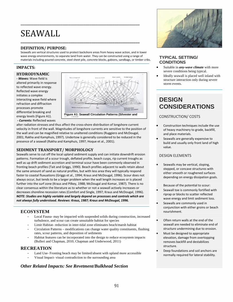
91
_________________________________________________________
SEAWALL _________________________________________________________
DEFINITION/ PURPOSE: Seawalls are vertical structures used to protect backshore areas from heavy wave action, and in lower wave energy environments, to separate land from water. They can be constructed using a range of materials including poured concrete, steel sheet pile, concrete blocks, gabions, sandbags, or timber cribs.
IMPACTS: HYDRODYNAMIC - Waves: Wave field is altered primarily in response to reflected wave energy. Reflected wave energy initiates a complex interacting wave field where refraction and diffraction processes promote differential breaking and energy levels (Figure A1). - Currents: Reflected waves alter radiation stresses and thus affect the cross-shore distribution of longshore current velocity in front of the wall. Magnitudes of longshore currents are sensitive to the position of the wall and can be magnified relative to unaltered conditions (Ruggiero and McDougal, 2001; Rakha and Kamphuis, 1997). Undertow is generally considered to be reduced in the presence of a seawall (Rakha and Kamphuis, 1997; Hoque et al., 2001).
SEDIMENT TRANSPORT/ MORPHOLOGY Seawalls serve to cut off the local upland sediment supply and can initiate downdrift erosion patterns. Formation of a scour trough, deflated profile, beach cusps, rip current troughs as well as up drift sediment accretion and terminal scour have been commonly observed in fronting beach profiles (Tait and Griggs, 1990). Beach profiles adjacent to walls retain about the same amount of sand as natural profiles, but with less area they will typically respond faster to coastal fluxuations (Griggs et al., 1994; Kraus and McDougal, 1996). Scour does not always occur, but tends to be a larger problem when the wall length increases or is placed further into the surf zone (Kraus and Pilkey, 1988; McDougal and Komar, 1987). There is no clear consensus within the literature as to whether or not a seawall actively increases or decreases shoreline recession rates (Comfort and Single, 1997; Kraus and McDougal, 1996). NOTE: Studies are highly variable and largely depend on processes and controls which are not always fully understood. Reviews: Kraus, 1987; Kraus and McDougal, 1996.
ECOSYSTEM - Local Fauna- may be impacted with suspended solids during construction, increased
turbulence, and scour can create unsuitable habitat for species - Limit Habitat- reduction in inter-tidal zone eliminates beach/marsh habitat - Circulation Patterns – modifications can change water quality constituents, flushing
rates, scour patterns, and deposition of sediments - Habitat features can be incorporated into the design to reduce ecosystem impacts
(Bulleri and Chapman, 2010; Chapman and Underwood, 2011) RECREATION
- Land Use- Fronting beach may be limited/absent with upland more accessible - Visual Impact- visual contradiction to the surrounding area
Other Related Impacts: See Revetment/Bulkhead Section
TYPICAL SETTING/ CONDITIONS
• Suitable in any-wave climate with more severe conditions being typical.
• Ideally seawall is placed well inland with structure interaction only during severe storm events.
DESIGN CONSIDERATIONS CONSTRUCTION/ COSTS
• Construction techniques include the use of heavy machinery to grade, backfill, and place materials.
• Seawalls are generally expensive to build and usually only front land of high value.
DESIGN ELEMENTS
• Seawalls may be vertical, sloping, stepped, or concave structures with either smooth or roughened surfaces depending on energy dissipation goals. Because of the potential to scour:
• Seawall toe is commonly fortified with riprap or blocks to scatter reflected wave energy and limit sediment loss.
• Seawalls are commonly used in conjunction with either groins or beach nourishment.
• Often return walls at the end of the seawall are needed to eliminate end of structure undermining due to erosion.
• Must be designed to appropriate elevation, damage from overtopping removes backfill and destabilizes structure.
• Deep foundations and soil anchors are normally required for lateral stability.
Figure A1: Seawall Circulation Patterns (Silvester and H 1993)

92
____________________________________________________
REVETMENT & BULKHEAD _________________________________________________________
REVETMENT: DEFINITION/ PURPOSE: Revetments are a cover or facing of material placed directly on an existing slope, embankment or dike to protect the area from waves and strong currents. Revetments are designed to armor and protect the land behind them and are commonly constructed using armorstone (high wave energy environments) or riprap stone (lower wave energy environments) in combination with smaller stone and geotextile fabrics. Other construction materials include gabions, poured concrete (usually in stepped fashion), pre-cast concrete blocks, and grout filled bags.
BULKHEAD: DEFINITION/ PURPOSE: Bulkheads are vertical structures or partitions, usually running parallel to the shoreline, for the purpose of retaining upland soils while providing protection from wave action and erosion. Bulkheads are either cantilevered or anchored sheet piles or gravity structures such as rock-filled timber cribs and gabions, concrete blocks or armorstone units.
IMPACTS: (SEE SEAWALL SECTION, NOTABLE DIFFERENCES DETAILED BELOW) HYDRODYNAMIC -REVETMENT: Generally dissipate more and reflect less wave energy due to construction (sloped and irregular surface) than vertical structures.
- BULKHEAD: Vertical structures typically experience increased scour and turbulence from reflected wave energy (USACE, 1995; Bush et al., 2004).
SEDIMENT TRANSPORT/ MORPHOLOGY As discussed within the seawall segment, waves are likely to impact these structures with sizable forces initiating movement of sand offshore, alongshore and away from the structure (Figure A2 & A3) (Kamphuis, 2000). Downdrift effects are typically present with any shore-parallel structure (Figure A2). -REVETMENT: Generally dissipate more wave energy providing less reflection due to the construction of a revetment structure when compared to a vertical structure/ seawall. - BULKHEAD: Vertical structures, in particular may exacerbate erosion of the foreshore.
ECOSYSTEM & RECREATION - All forms of parallel structures interfere with natural habitat migration and limit
intertidal habitat variability while increasing coastal stability and providing backshore protection to residential, commercial and recreational interests
- Habitat features can be incorporated into the design to reduce ecosystem impacts (Bulleri and Chapman, 2010; Chapman and Underwood, 2011)
TYPICAL SETTING/ CONDITIONS
• REVETMENT: Typically found in equal or less energetic environments compared to seawalls.
• BULKHEAD: Typically found in less energetic environments compared to both revetments and seawalls, more common in sheltered settings.
DESIGN CONSIDERATIONS CONSTRUCTION/ COSTS
• Costs vary considerably depending on anticipated loading, design height, construction materials and location; typical range 0.4 to 27.5 Million dollars per 1-km stretch (Linham et al., 2010).
• Continued investment is necessary to ensure protection at design levels, additional rock every 5-10 yrs typical.
DESIGN ELEMENTS
• Designed scour depth similar to incident wave height at base of structure (Dean and Dalrymple, 2002).
• Recommended maximum slopes of 1:3 to reduce scour (Pilarczk, 1990).
• REVETMENT: Usually geotextile fabric is laid as a base layer to prevent base sand from washing out.
• BULKHEAD: Usually a vertical structure, typically of timber or sheet pile.
Figure A2: Shore-Parallel Structure Erosion Patterns (Linham and Nicholls, 2010; after McDougal et al., 1987).
Figure A3: Shore-Parallel Structure potential Scour Erosion Patterns (Linham and Nicholls 2010).

93
____________________________________________________
GROIN _________________________________________________________ DEFINITION/ PURPOSE: Groins are structures that extend perpendicular or at nearly right angles from the shore and are relatively short when compared to navigation jetties at tidal inlets. Often constructed in groups called groin fields, their primary purpose is to trap and retain sand. Groins can be constructed from a wide range of materials including armorstone, pre-cast concrete units or blocks, rock-filled timber cribs and gabions, steel sheet pile, timber sheet pile, or grout filled bags and tubes.
IMPACTS: HYDRODYNAMIC - Waves: Incident waves undergo diffraction and refraction toward and around the structure. Incoming wave dynamics are largely unaltered (e.g., no additional dissipation, reflection, etc). -Currents: Longshore currents are interrupted and redirected by the structure. Rip currents can develop adjacent to groins by the deflection of longshore currents seaward or by differential water levels (due to wave diffraction) causing a seaward flow along the updrift of the structure. Rip currents can develop on the downdrift and/or updrift portion of the groin depending on prevailing wave conditions (Kraus and Pilkey, 1988; Silvester and Hsu, 1993). SEDIMENT TRANSPORT/ MORPHOLOGY Structure serves to intercept sediment moving alongshore, sediment accretes on the updrift side while erosion predominates on the downdrift (Figure A4) (Woodroffe, 2002). The short section of beach between structures realigns itself with the dominate wave direction. Sediment bypasses groins when they are filled to capacity (Kamphuis, 2000). Overall formation may resemble a ‘sawtooth’ upon the formation of equilibrium beaches. There is a potential for offshore directed materials to be moved onto bars and lost to the nearshore zone (Dean and Dalrymple, 2002).
ECOSYSTEM - Local Fauna- may become buried or die out due to sand mobilization - Local biodiversity- spatial variations in invertebrate communities and aquatic wildlife
may be a consequence - Longshore current modulation– creation of barriers of movement for benthic animals
and wrack materials within ecosystem - Stabilized habitat- increased sediment stability can protect dunes/ backshore
environments RECREATION
- Allows for enhanced recreational use on the updrift side of the structure - Potentially hazardous swimming conditions created by offshore currents
TYPICAL SETTING/ CONDITIONS
• Generally suitable in most wave climates provided there is significant longshore transport.
• Typically placed within the surf zone perpendicular to the shoreline.
• Structures are usually placed in a series to protect a greater stretch of shoreline and to limit downdrift erosion.
DESIGN CONSIDERATIONS CONSTRUCTION/ COSTS
• Considered to be a low cost solution with variable crest elevation construction a viable option.
• Rubble mound construction favorable at high energy open coast sites, where low vertical structures are suitable for low wave energy.
DESIGN ELEMENTS
• Designed to retain sediment: -Length: 40-60% of surf zone width -Spacing: 2-4x length of the groin -Height: typically 0.3-0.5m above beach.
• Incident wave angle, spacing, and length largely dictate production of rip currents, retention, and scour.
• Can be constructed to reduce impact of currents and tides, and to avoid sediment starvation (segmented/permeable).
• Downdrift erosion can be limited by a groin transition zone.
• Beach nourishment generally accompanied with groin installation to provide initial accretionary material for landform stabilization.
• Results are typically better in coarser grained beach settings.
Figure A4: Groin Sedimentation Patterns (USACE, 2002a).

94
_____________________________________________________
JETTY _________________________________________________________ DEFINITION/ PURPOSE: Jetties are structures that extend perpendicular or at nearly right angles from the shore commonly used to limit the volume of sediment deposited in inlet channels and prevent inlet migration.
IMPACTS: HYDRODYNAMIC - Waves: Incident waves undergo diffraction and refraction toward and around the structure. Potential for incident wave energy to enter through inlet and refract toward channel banks. -Currents: Like groins, longshore currents are interrupted and redirected by the structure. Complex current interaction likely present at mouth of stabilized inlet.
SEDIMENT TRANSPORT/ MORPHOLOGY Structures are designed to completely sever the longshore sediment transport pathways; updrift sedimentation and downdrift erosional features can be extensive depending on the magnitude of littoral drift (Dean and Dalrymple, 2002). When littoral drift rates are exceptionally high, dredging or bypassing may be required to move trapped sediments (Figure A5) (French, 2001). Potential for offshore losses due to reflected currents.
ECOSYSTEM - Longshore current modulation– creation of barriers of movement for benthic animals
and wrack materials within ecosystem - Stabilized habitat- increased sediment stability can protect dunes/ backshore
environments
RECREATION - Increased recreational usages linked to fishing - Potentially hazardous swimming/ boating conditions caused by complex current and
wave interactions
Other Related Impacts: See Groin, Beach Nourishment & Dredging Sections
TYPICAL SETTING/ CONDITIONS
• Generally most suitable in most wave climates provided there is longshore transport.
• Typically built well beyond the surf zone • Structures are usually placed on either
side of harbors/ river inlets as single structures to stabilize and protect navigation channels.
DESIGN CONSIDERATIONS CONSTRUCTION/ COSTS
• High cost incurred during both construction and maintenance phases of projects.
• Rubble mound or concrete block construction favorable along dominate high-energy open coast sites.
DESIGN ELEMENTS
• Must be designed to withstand large amounts of wave energy due to deeper water offshore conditions.
• High water levels, significant wave heights and impact loads considered.
• Sediment bypassing and/or beach nourishment and dredging are often employed concurrently to increase downdrift sediment supply.
Figure A5: Groin Circulation Patterns (USACE, 2002).

95
_________________________________________________________
OFFSHORE BREAKWATER _________________________________________________________
DEFINITION/ PURPOSE: Breakwaters are shore-parallel structures that reduce the amount of wave energy reaching a harbor or stretch of shoreline located behind the structure. Breakwaters are similar to natural bars, reefs or nearshore islands and are designed to dissipate wave energy. The reduction in wave energy results in gradients in littoral drift, causing sediment deposition (salients and tombolos) in the sheltered area behind the breakwater. Some longshore sediment transport may continue along the coast behind the breakwater. Structures can be detached, attached, or utilized as a headland control feature depending on design and functionality characteristics.
IMPACTS: HYDRODYNAMIC - Waves: The incident wave energy is broken up by the breakwater causing wave diffraction around the structure within the embayments. “The wave field behind the breakwater for a normally incident wave train can be envisioned as overlapping semicircular wave patterns emanating from the tips of the breakwaters” (Figure A6) (Dean and Dalrymple, 2002). - Currents: A current driven by differential breaker heights (higher where less wave energy has been lost between structures) drives flow (and thus sediment) towards the centerline of the structure. The existence of any depositional feature will alter the behavior of the longshore current in the system; a salient may behave like a groin deflecting longshore currents around the seaward side of the structure (Figure A6) (French, 2001). The structure may impede the magnitude of natural flushing and thus cross-shore currents.
SEDIMENT TRANSPORT/ MORPHOLOGY “ Sand transported along the beach is carried into the sheltered area behind the breakwater where it is deposited in the lower wave energy region. Protection afforded by the breakwater will limit erosion of the salient during significant storms and promote growth during periods of low to moderate wave activity” (USACE, 1992). Depending on the local hydrodynamic conditions, accretion may form into a bulge (salient) or connect the structure to the shoreline (tombolo).
ECOSYSTEM - Local Fauna- may become buried or die out due to sand mobilization - Coastal Vegetation- altered due to change in inundation/ salt spray patterns - Circulation Patterns – potentially reduced altering preferential placement of
vegetation/ biodiversity and pollutant buildup - Stabilized habitat- preservation of local marshes and intertidal habitat
RECREATION - Allows for recreational opportunities in the sandy lee of the breakwater - Potentially hazardous swimming conditions (current) within the embayment –
magnified during storms
TYPICAL SETTING/ CONDITIONS
• Generally most suitable in mild-wave climates primarily due to rising costs associated with construction in highly energetic open ocean systems.
• Typically placed seaward of the surf zone parallel to the shoreline.
• Structures can be placed in tandem/ series to protect a greater stretch of shoreline.
DESIGN CONSIDERATIONS CONSTRUCTION/ COSTS
• Construction can be from the water using barges, from a temporary trestle, or from a temporary embankment built out from shore to the breakwater site.
• The cost of breakwaters increases with water depth and wave climate severity. Also poor foundation conditions significantly increase costs. These three environmental factors heavily influence the design and positioning of the breakwaters.
DESIGN ELEMENTS
• Typically designed as rubble-mounted structures with varying layers of rock for structural integrity.
• The degree of interaction of the breakwater with the natural system, depends on the breakwater crest elevation, alongshore length, and separation distance from the shore (Dean and Dalrymple, 2002).
• Beach nourishment generally accompanied with breakwater installation to provide initial accretionary material for landform stabilization.
Figure A6: Breakwater Circulation Patterns (Silvester et al., 1989).
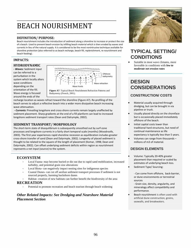
96
_____________________________________________________
BEACH NOURISHMENT __________________________________________________________
DEFINITION/ PURPOSE: Beach nourishment includes the introduction of sediment along a shoreline to increase or protect the size of a beach. Used to prevent beach erosion by infilling beach material which is then eroded by waves and currents in lieu of the natural supply. It is considered to be the most nonintrusive technique available for shoreline protection (also referred to as beach recharge, beach fill, replenishment, re-nourishment and beach feeding).
IMPACTS: HYDRODYNAMIC - Waves: Sediment input can be referred to a perturbation in the system which locally alters wave conditions depending on the orientation of the fill. Wave energy is focused around the ends of the recharge location as waves refract toward the shoreline (Figure A7). Re-profiling of the beach serves to adjust a reflective beach into a wider more dissipative beach increasing wave attenuation. - Currents: Prevailing longshore and cross-shore currents remain largely unaffected by sediment placement. Sharp gradients at the end of a fill planform can lead to increased longshore sediment transport rates (Dean and Dalrymple, 2002). SEDIMENT TRANSPORT/ MORPHOLOGY The short-term state of disequilibrium is subsequently smoothed out by surf-zone processes and longshore currents in a fairly short temporal scale (months) (Woodroofe, 2003). The first year experiences rapid shoreline recession as equilibration includes greater cross-shore transfer of sand (Dean and Dalyrmple, 2002). Longevity of placed sediment is thought to be related to the square of the length of placement (Komar, 1998; Dean and Dalyrmple, 2002). Can offset underlying sediment deficits within region as nourishment represents a net input (source) to the system.
ECOSYSTEM - Local Fauna- may become buried or die out due to rapid sand mobilization, increased
turbidity, and potential grain size alterations - Local Biota- can negatively impact nesting sites for indigenous species - Coastal Dunes- can cut off aeolian sediment transport processes if sediment is not
sourced properly, harming backshore dunes - Habitat- creation of new habitats can further benefit the biodiversity of the area
RECREATION - Potential to promote recreation and beach tourism through beach widening
Other Related Impacts: See Dredging and Nearshore Material Placement Section
TYPICAL SETTING/ CONDITIONS
• Suitable in most wave climates, more favorable in conditions with low to moderate net erosion rates
DESIGN CONSIDERATIONS CONSTRUCTION/ COSTS
• Material usually acquired through dredging, but can be brought in via pipeline or truck.
• Usually placed directly on the shoreface but is occasionally placed immediately offshore of the beach.
• Initial capital costs lower than traditional hard structures, but need of continual maintenance as life expectancy is typically less than 5 years.
• Volumes can range from thousands – millions of m3 of material.
DESIGN ELEMENTS
• Volume: Typically 20-40% greater placement than required or scaled by estimates of underlying beach loss.
• Sediment Type/ Sourcing:
- Can come from offshore, back-barrier, or dune environments or terrestrial sources - Grain size, density, angularity, and mineralogy affect compatibility and performance.
• Beach nourishment is often used with artificial dune construction, groins, seawalls, and breakwaters.
Figure A7: Typical Beach Nourishment Refraction Patterns and Bathymetry (French, 2001).

97
_____________________________________________________
DREDGING AND NEARSHORE MATERIAL PLACEMENT __________________________________________________________
DEFINITION/ PURPOSE: Dredging is the mechanical removal of sediment, often used to increase or maintain the depth of a navigable waterway and/or provide sediments during beach nourishment activities.
IMPACTS: HYDRODYNAMIC - Waves: The act of dredging material may change bathymetry levels which can in turn initiate wave refraction, diffraction, dissipation and reflection affecting energy levels, arriving along the shore (e.g., borrow pits). - Currents: Prevailing longshore and cross-shore currents remain largely unaffected by dredging activities, though harbor/ inlet current interactions may be altered. SEDIMENT TRANSPORT/ MORPHOLOGY Changes to seafloor bathymetry may change local hydrodynamic processes initiating changes in shoaling patterns and contribute to increases erosion or salient formation (Figure A8).
Also See Beach Nourishment Section
ECOSYSTEM - Infauna- mortality due to substrate removal and disposal, changes in subsequent
substrate patterns. - Fish and mobile invertebrates may become trapped in equipment during operations - Organism decline - substantial decrease in the number and diversity of organisms
following a dredging event (Order 84-90%) (Greene, 2002). - Often sites recover quickly from the dredging event (~1year)
RECREATION - Act of dredging may detract from physical setting as well as provide an obstacle for
maritime vessels Other Related Impacts: See Beach Nourishment Section
TYPICAL SETTING/ CONDITIONS
• Method can be used in either exposed or sheltered environments.
DESIGN CONSIDERATIONS CONSTRUCTION/ COSTS
• Material usually acquired through dredging, but can be brought in via pipeline or truck.
• Usually placed directly on the shoreface but is occasionally placed immediately offshore of the beach.
• Initial capital costs lower than traditional hard structures, but need continual maintenance as life expectancy is typically less than 5 years.
• Volumes can range from thousands – millions of m3 of material.
DESIGN ELEMENTS
• Shallower location preferred for ease of retrieval, while location beyond depth of closure best for transport implications.
Figure A8: Salients on Grand Isle, Louisiana, due to offshore borrow pits (from Combe and Soileau, 1987).

98
_________________________________________________________
ATTACHED BREAKWATER/ HEADLAND CONTROL STRUCTURE ______________________________________________________________ DEFINITION/ PURPOSE: Headland control concept of systematically placing structures (typically breakwaters) to create artificial headlands in an effort to promote equilibrium beach formation. Bays are formed between these headlands of crenulate shape, such that diffraction and refraction cause accretionary waves to develop normal to the coast. This is intended to result in a stable shoreline even if sediment is still passing through a system of headlands. This concept is often employed as a regional approach to shore protection.
IMPACTS:
HYDRODYNAMIC - Waves: Shoreline structure provides wave sheltering by diffraction combined with refraction to promote equilibrium shoreline shapes (parabolic shape/ logarithmic spiral) (Moreno and Kraus, 1999). On the downdrift side of the structure diffraction and refraction form a curved beach profile (Silvester and Hsu, 1993). - Currents: Once an equilibrium planform is achieved, waves break simultaneously around the entire periphery initiating no longshore currents nor littoral drift within within the embayment (USACE, 2002a). SEDIMENT TRANSPORT/ MORPHOLOGY Waves initially diffract around the headland and refract into the bay, waves breaking at angles drive sediment transport adjusting the planform (USACE, 2002a). Erosion between the structures is thought to lead to the equilibrium planform, spiral bay ‘pocket beach’ (Figure A9) (Dean and Dalyrymple, 2002). The technique can be designed to reorientate the beach to promote static or dynamic equilibrium, where littoral drift is altered or continued in the presence of the structural system (Hsu, 1989; Silvester and Hsu, 1993). Overall, minimal amounts of additional sediments leave or enter past the artificial headlands (USACE, 2002a). Unlike offshore breakwaters, these structures are designed to prevent transport in the lee of the structure which results in the formation of stable bays as defined by the incident wave direction (Rogers et al., 2010).
ECOSYSTEM & RECREATION - Circulation Patterns – potentially reduce wave and tidal energy initiating fine
sediment and pollutant buildup - Stabilized habitat- preservation of local marshes and intertidal habitat - May offer public access beach amenity and platform for wildlife viewing - Potential health and safety risk
TYPICAL SETTING/ CONDITIONS
• Suitable in most any environment provided a predominate wave direction is present
DESIGN CONSIDERATIONS CONSTRUCTION/ COSTS
• Often employs the use of shore attached breakwaters and revetments to mimic natural formations normally generated by cliffs, etc.
• The costs are highly variable, and similar to groin and breakwater construction patterns.
DESIGN ELEMENTS
• Typically designed as rubble-mounded structures with varying layers of rock for structural integrity.
• Inadequate height may lead to overtopping, increased erosion, and eventual structure separation (Dean and Dalrymple, 2002).
• Design largely dependent on dominate incoming wave directions.
• Bays are designed to simulate nature • Important to establish appropriate
‘control points’ with which the bays are to form.
• Design process involves iterative solution relating control points, incoming wave energy, and desired shoreline position.
• Parameters include approach direction of wave energy, length of individual headland units, spacing, location, crest elevation, and width and artificial nourishment (USACE, 1992).
Figure A9: Definition sketch for Headland Breakwater concept (USACE, 2002).

99
____________________________________________________
DYNAMIC REVETMENT _________________________________________________________
DEFINITION/ PURPOSE: A dynamic revetment is a structure designed to prevent erosion by providing a level of stability to the backshore with the strategic placement of cobbles, as such it can considered to be a combination between a revetment and courser grained beach nourishment. Whereas a traditional revetment remains 'static' in the face of hydrodynamic conditions, a dynamic revetment is designed (as an artificial profile) to be flexible depending on the nearshore conditions, moving with wave and currents. The berm itself can be located within the intertidal zone or behind a sandy beach to provide protection. The techniques may be combined with an artificial dune or toe protection along adjacent bluff/dunes to provide for surge protection.
IMPACTS: HYDRODYNAMIC - Waves: Based on experiences with natural cobble beaches, it is thought that these constructed solutions are able to better absorb and dissipate wave energy than a comparable sandy beach. This is due to the sloping, porous cobble nature of the beach is able to disrupt and dissipate wave energy (Allan et al., 2005). - Currents: Currents are thought to remain unaffected by the altered sediment size, though a steepened beach associated with more coarse materials may affect currents.
SEDIMENT TRANSPORT/ MORPHOLOGY Natural sediment transport processes remain the same, though, given the difference in grain size and density it becomes harder for the coarser material to be transported. Cobble beaches have been found to naturally steepen in response to increasing wave energy, thus adjusting its morphology (Komar et al., 2003). Cobbles have been found to preferentially migrate within the prevailing littoral transport regime, the magnitude of which is related to wave conditions and grain size (Allan and Komar, 2010). It has been observed that gravel beaches tend to accrete and increase in height during storms where as sandy beaches tend to erode (Everts et al., 2002; Allan and Hart, 2007). As with other techniques, this alternative form of armoring may also contribute to downdrift erosion.
ECOSYSTEM - Local Substrate- cobble placement may complement natural morphology or
potentially cover up existing beach habitat - Habitat – potentially reduced altering preferential placement of vegetation and
sediment infauna RECREATION
- Has the potential to limit/change beach usage and access - Provides for a more natural appearance that does not detract from local scenery
TYPICAL SETTING/ CONDITIONS
• Technique can be used in a wide range of wave climates including sheltered and exposed areas depending on design.
• Can be located within the intertidal zone or behind a sandy beach.
• Few existing applications make it difficult to access general range of usefulness.
DESIGN CONSIDERATIONS CONSTRUCTION/ COSTS
• Construction is significantly easier for a revetment, as material placement does not require special attention.
• Cost of installation is considered to be moderate due to relatively inexpensive material especially when locally sourced.
• Maintenance is typically required frequently than for traditional revetment structures, as gravels and cobbles are able to be mobilized by waves (Allan and Hart, 2007).
DESIGN ELEMENTS
• Typically designed to be as close as possible to natural cobble beaches in order to ensure natural compatibility and natural stability (Komar et al., 2003).
• Will not provide the same level of protection as a standard revetment or seawall structure.
Figure A10: Example of Hybrid "Design with Nature" approach, cobble berm and revetment combination (from Komar and Allan, 2010).
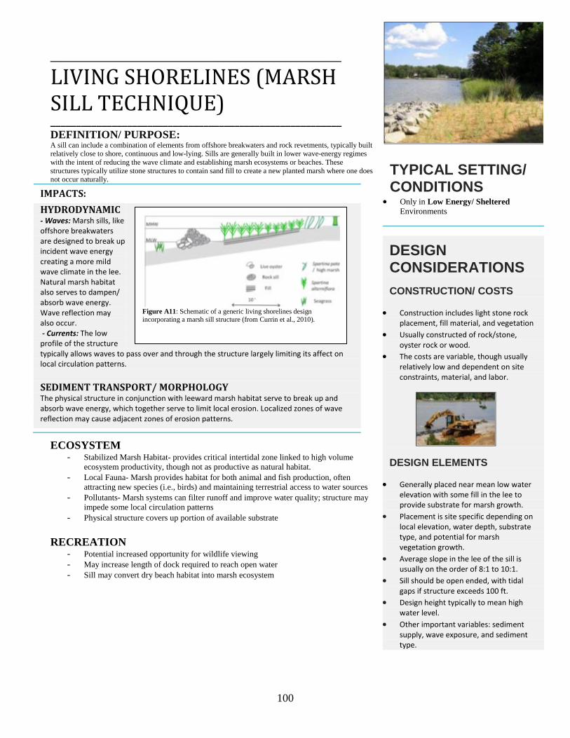
100
____________________________________________________
LIVING SHORELINES (MARSH SILL TECHNIQUE) _________________________________________________________ DEFINITION/ PURPOSE: A sill can include a combination of elements from offshore breakwaters and rock revetments, typically built relatively close to shore, continuous and low-lying. Sills are generally built in lower wave-energy regimes with the intent of reducing the wave climate and establishing marsh ecosystems or beaches. These structures typically utilize stone structures to contain sand fill to create a new planted marsh where one does not occur naturally.
IMPACTS: HYDRODYNAMIC - Waves: Marsh sills, like offshore breakwaters are designed to break up incident wave energy creating a more mild wave climate in the lee. Natural marsh habitat also serves to dampen/ absorb wave energy. Wave reflection may also occur. - Currents: The low profile of the structure typically allows waves to pass over and through the structure largely limiting its affect on local circulation patterns. SEDIMENT TRANSPORT/ MORPHOLOGY The physical structure in conjunction with leeward marsh habitat serve to break up and absorb wave energy, which together serve to limit local erosion. Localized zones of wave reflection may cause adjacent zones of erosion patterns.
ECOSYSTEM - Stabilized Marsh Habitat- provides critical intertidal zone linked to high volume
ecosystem productivity, though not as productive as natural habitat. - Local Fauna- Marsh provides habitat for both animal and fish production, often
attracting new species (i.e., birds) and maintaining terrestrial access to water sources - Pollutants- Marsh systems can filter runoff and improve water quality; structure may
impede some local circulation patterns - Physical structure covers up portion of available substrate
RECREATION
- Potential increased opportunity for wildlife viewing - May increase length of dock required to reach open water - Sill may convert dry beach habitat into marsh ecosystem
TYPICAL SETTING/ CONDITIONS
• Only in Low Energy/ Sheltered Environments
DESIGN CONSIDERATIONS CONSTRUCTION/ COSTS
• Construction includes light stone rock placement, fill material, and vegetation
• Usually constructed of rock/stone, oyster rock or wood.
• The costs are variable, though usually relatively low and dependent on site constraints, material, and labor.
DESIGN ELEMENTS
• Generally placed near mean low water elevation with some fill in the lee to provide substrate for marsh growth.
• Placement is site specific depending on local elevation, water depth, substrate type, and potential for marsh vegetation growth.
• Average slope in the lee of the sill is usually on the order of 8:1 to 10:1.
• Sill should be open ended, with tidal gaps if structure exceeds 100 ft.
• Design height typically to mean high water level.
• Other important variables: sediment supply, wave exposure, and sediment type.
Figure A11: Schematic of a generic living shorelines design incorporating a marsh sill structure (from Currin et al., 2010).

101
________________________________________________________
DUNE BUILDING _________________________________________________________
DEFINITION/ PURPOSE: Dune construction is the piling up of beach quality sand to form protective dune fields to replace those washed away during severe storms. An essential component of dune reconstruction is planting of dune vegetation and placement of netting or snow fencing to help retain wind-blown sand normally trapped by mature dune vegetation. Storm overwash fans may be a viable source of material for dune construction (USACE, 2002a).
IMPACTS: HYDRODYNAMIC Dunes are very dynamic backshore features adjusting to prevailing wind, water level and wave climates (French, 2001). These features constantly interact with the beach.
- Waves: Sediment stored in dunes can have an indirect effect on hydrodynamic properties as this sediment can compensate for the removal of sand from the beachface during erosion. This can help maintain a wide sandy beach able to dissipate income wave energy (Linham and Nicholls, 2010). - Currents: Prevailing longshore and cross-shore currents remain largely unaffected by dune formation.
SEDIMENT TRANSPORT/ MORPHOLOGY Dunes serve to protect the backshore and provide a temporary store of sediment to allow for short term adjustments of the beach during a storm Figure A12) (Nordstom, 2000). Built dune environments require initial sediment source and can represent a gradual sediment deficit to the system until fully equilibrated. There needs to be adequate sediment supply to facilitate short term erosion and accretion processes (French, 2001). Dune growth is a function of the aeolian sediment transport rate and the effectiveness of vegetation, fencing and/or the dune itself to retain sand (USACE, 2002a). Dunes typically trap sand toward the seaward side, and grow towards the fronting beach.
ECOSYSTEM - Local Fauna- may become buried or die out due to sand mobilization - Coastal Vegetation- altered due to potentially intrusive placement - Habitat Restoration- Many regions may have had dunes before development;
restoration of these features provides for a lost naturally occurring habitat - Stabilized habitat- provide coastal habitat for many highly specialized plants and
animals (Linham and Nicholls, 2010)
RECREATION - Land Use- land loss due to dune footprint - May serve to encourage sustainable development within coastal zone - May represent a barrier to beach access/ impede view of the ocean
TYPICAL SETTING/ CONDITIONS
• Generally most suitable along wide sandy beaches.
• Artificial dune creation and dune restoration can be carried out on existing beaches, beaches built through nourishment, existing dunes, and undeveloped land.
DESIGN CONSIDERATIONS CONSTRUCTION/ COSTS
• Dune building methods include manual sand placement, reshaping of sand deposits, geotextile bags, installation of sand fences, and/or vegetative planting to promote dune growth.
• Construction and maintenance of small scale fencing and vegetative methods may be accomplished at the community level.
• Costs associated with dune building are relatively minor and variable depending on method(s) employed.
DESIGN ELEMENTS
• Dune construction is commonly carried out in conjunction with beach nourishment (with available sediment present).
• Dune placement, height, mobility constraint and vegetative properties are important to long-term viability.
• Typically placed parallel beach features, a 60m offset from the high water line is often recommended (USACE, 1984a).
• Size and shape of dune can be controlled by strategically placing fencing/ material.
Figure A12: Dune processes during a storm (Environment Waikato, 2001).

102
_________________________________________________________
BEACH SCRAPING _________________________________________________________
DEFINITION/ PURPOSE: Beach scraping is the recovering of material from the foreshore (low-tide beach) to the upper back-beach through mechanical means. It is an attempt to mimic the natural beach recovery process following a storm event (Figure A13). Unlike dune building or beach nourishment this technique does not typically include placement of additional materials, rather a redistribution of the available sediment within the beach profile in an effort to reduce erosion.
IMPACTS: HYDRODYNAMIC - Waves: Concept involves removing sand from the lower beach (moving it upward) to create a flatter profile and thus promoting sediment accretion as more wave energy is dissipated (Smutz et al., 1980). - Currents: Prevailing longshore and cross-shore currents remain largely unaffected by the re-profiling effort.
SEDIMENT TRANSPORT/ MORPHOLOGY Re-profiling of the beach just changes the surface; protective beach width may be slightly enhanced over the short term but inconsequential in providing long term protection (Bush et al., 1996). Sourced (borrow) materials are typically recovered from beach ridges formed at the top of the up-rush zone in spring or summer (Brunn, 1983). Objectives include building a wider, higher high tide dry beach, fill in trough-like lows and encourage additional sand accretion on the lower beach (Bush et al., 1996). Intended to encourage onshore migration of sand. Interrupts local sediment supply (longshore drift) initiating downdrift erosion and can steepen the beach profile (Wells and McNinch, 1991). Increasing dry sediment volume typically increases aeolian sediment transport processes (Conaway and Wells, 2005). NOTE: Overall little research has been done with relation to this practice. Some information: McNinch, 1989; Wells and McNinch 1991; Dare, 2003; Carley et al., 2010.
ECOSYSTEM - Local Fauna- destruction of beach organisms due to construction practices, burial
during creation of artificial foreshore, alteration to foraging, nesting and breeding patterns of avifauna and turtles
- Coastal Vegetation- can disrupt the natural process of dune evolution - Habitat- directly destroyed during scraping procedures
RECREATION
- Widening of the beachfront enhances recreation use and tourism features
TYPICAL SETTING/ CONDITIONS
• Generally most suitable along wide sandy beaches and on parts of the beach inundated by daily tides.
• Likely to work best on equilibrated or mildly eroding beaches (Dare, 2003).
DESIGN CONSIDERATIONS CONSTRUCTION/ COSTS
• Generally requires a bulldozer or other heavy machinery (drag, grader, front- end loader, etc.) for sand relocation.
• Minimal costs primarily associated with equipment and labor.
• Often used as a preventative measure for winter storms or as an emergency response on a small scale.
DESIGN ELEMENTS
• An experimental practice, with little guidance available for application.
• Includes removing a thin lay of sand (0.2-0.5m), varying with sediment grain size.
• Commonly used in combination with re-vegetation schemes during dune building projects.
Figure A13: Beach Scraping Schematic (from Carley et al., 2010).
Figure A14: Beach Scraping Schematic (from Carley et al., 2010).

103
_________________________________________________________
BEACH DEWATERING _________________________________________________________
DEFINITION/ PURPOSE: Beachface dewatering (Beach drain) is designed to prevent beach erosion by promoting the accumulation of sands on the drained portion of the beach. These systems are constructed using perforated pipe, filter material and/or well points combined with mechanical pumping and gravity systems to provide groundwater drawdown along the swash zone.
IMPACTS: HYDRODYNAMIC - Concept: The technique is based on artificially lowering of groundwater table in the swash zone (Figure A15) which initiates increased infiltration of uprush water and thus a decreased downrush water volume. - Waves: Incident wave energy is unaffected by this technique unless the beach profile is adjusted (re-profiled) due to the processes, in which case accretion on the lower portion of the beach may provide for a more dissipative setting. - Currents: Prevailing longshore and cross-shore currents remain largely unaffected by the technique, although if large quantities of down rush are eliminated alterations to cross-shore currents may be possible, however unlikely.
SEDIMENT TRANSPORT/ MORPHOLOGY Beach dewatering is thought to increase the effective sediment fall velocity of suspended swash zone sediments by inducing a small vertical component of velocity within the fluid (Dean and Darymple, 2002). Increased deposition on the beachface is thought to be a product of the reduction in downrush water volume and changes in sediment fall velocity (Dean and Darymple, 2002). This technique may also initiate beach steepening and a narrow swash zone (Bowman et al., 2007). Any induced sediment deposition will come at the expense of downdrift beaches, increased dry beachface will likely increase aeolian sediment transport processes (Conaway and Wells, 2005). NOTE: Overall little research has been done with relation to this technique. The technique is thought to be experimental (Bruun, 2005) and the underlying physical mechanisms linking GW elevation and accretion are not fully resolved (Turner and Leatherman, 1997).
ECOSYSTEM - Local Fauna/ Habitat- will change habitat within the swash zone initiating drying
conditions which may be adverse to sea turtle nesting and others. - Habitat- destruction with initial system setup when using backhoe/trenching
RECREATION
- Stabilize beach- provides for a dry beachface that is potentially more stable - May provide false sense of security as a shore protection device.
TYPICAL SETTING/ CONDITIONS
• Generally most suitable in mild-wave/ wind climates as the system will not stop beach or dune erosion during storms.
• Technique is thought to be more effective in environments with higher permeability sands, locations with existing groundwater discharge along the beachface, and areas with micro-tidal environments to maximize the techniques effectiveness.
DESIGN CONSIDERATIONS CONSTRUCTION/ COSTS
• The simplest method is to install pipe drains or lines for flow – gravity dewatering, while another common method is to link a series of pipes to a central drain from which water is collected and pumped (French, 2001).
• Fairly low initial and maintenance costs when compared to nourishment.
• Multiple drainage systems may be required to cover the extent of the beach profile (Dare, 2003).
DESIGN ELEMENTS
• There are no design guidelines related to the installation and usage of the BDS; these systems are based off installers estimated guidance to the placement, burial depth, pipe quantity, diameter, length, pumping rate etc.
• Installation is particularly vulnerable to destructive wave climates and events.
• Is considered to be an environmentally and aesthetically pleasing alternative to hard structures though there is no guarantee of protection.
Figure A15: Schematic diagram of beach dewatering system (from Turner and Leatherman, 1997).

104
Appendix B-- Summary of National Park Service CEI Project Impacts Assessment
The Coastal Engineering Inventory (CEI) project aims to inventory, catalog and map coastal engineering
projects in and adjacent to coastal units of the National Park Service (NPS). The primary projects that
are inventoried include coastal structures, dredge and fill projects, and beach nourishment and dune
construction projects. To date, an inventory of coastal engineering projects has been developed for 18
coastal national parks, including four along the U.S. West Coast. Reports and GIS data are available
online at http://irma.nps.gov. Here we provide a brief description of the methodologies used and some of
the general results for the four west coast parks that have been inventoried.
A digital park boundary shapefile for all of the inventoried parks was downloaded from the NPS
Integrated Resources Management Applications Portal (https://irma.nps.gov). Geo-referenced digital
orthophoto imagery was obtained from each park and added to ArcMap 10.0 to create a basemap. A
visual inspection of the orthophoto imagery was completed and locations of all discernible coastal
structures were digitized using ArcMap. A site visit to the park, along with staff correspondence, was
used to complement and confirm initial findings based on examination of the imagery and to identify
other coastal engineering projects. A comprehensive online and hardcopy literature search was
undertaken to obtain attribute data for each project (year of construction, material, year of maintenance,
cost, lead construction agency, and volume).
A coastal engineering project was considered distinct if there was any discernible, physical separation
between it and an adjacent engineering project. A series of bulkheads constructed by individual interests,
for example, would be classified as one structure as long as no identifiable gaps were observed between
them. Some projects, such as dredge projects that place dredge spoil on the beach, serve multiple
purposes (i.e., dredging and beach nourishment). In these cases, the primary reason for the project was
ascertained and the project was classified accordingly. Projects that occurred repeatedly in one location
(e.g., dredging an inlet or nourishing a beach) were counted as one project.
Overview statistics were calculated to summarize the coastal engineering projects within each park. The
percentage of shoreline armored by coastal structures was found by totaling the length of bulkheads,
breakwaters, groins, revetments, seawalls, and sills (while removing overlapping structures) and
dividing it by the total length of shoreline. Structure length and shoreline length were determined using

105
ArcMap. The structure length used in calculating the percentage of shoreline armored for individual
structures was merely the length of the structure. For groin fields (defined here as three or more groins)
the length was set as the length of the groin field along the shoreline.
Appendix B1 - Summary of GOGA CEI Findings
One hundred and sixteen coastal engineering projects were found in and adjacent to GOGA. Of this
total, 94 are coastal structures that together extend nearly 26 km (16 mi). Coastal structures armor
roughly 76% of the park’s northern San Francisco shoreline from the Golden Gate Bridge to Fort Mason
and approximately 46% of the shoreline along Ocean Beach’s 7-kilometer (4.3 mi) long beach.
Dredge and fill projects have altered over 5.7 km2 (1,400 ac) of submerged and sub-aerial lands within
and adjacent to GOGA. The most significant project (by size and volume) is the Main San Francisco
Ship Channel, offshore and outside of GOGA. Since 1931, channel dredging has removed nearly 41
million m3 (53 million yd3). Aggregate mining within central San Francisco Bay and on Ocean Beach
has removed over 19 million m3 (24 million yd3) of sediment between 1953 and 2008.
Modifications to sediment input combined with coastal engineering projects have changed the natural
sediment transport dynamics within San Francisco Bay. These projects have directly affected much of
GOGA’s 95 km (59 mi) of coastline.
Crissy Field was historically a salt marsh and estuary, and its filled wetlands have contributed to a
system-wide trend of ecosystem degradation, habitat loss and tidal prism alteration. Recent efforts have
restored this site to a more natural state. However, new hydrodynamic and sediment transport impacts
related to tidal impoundment and water quality exist.
Ocean Beach represents a heavily engineered system with a long history of filling, beach and dune
nourishment, and hard structure installation. Anthropogenic impacts within San Francisco Bay have
changed sediment delivery to the outer coast, impacting the ebb-tidal delta as well as shoreline change
rates along Ocean Beach.

106
Appendix B2 - Summary of SAFR CEI Findings Twelve coastal engineering projects were identified within SAFR. Of this, nine are coastal structures
that span 2,275 m (7,465 ft) (this includes 324 m [1,063 ft] of a breakwater that is outside SAFR). The
Aquatic Park Seawall armors roughly 88% of the total shoreline within the park. The park’s cove was
filled with an unknown volume of material from 1906–1914 and again in the 1930s. In 1941, 2.3 million
m3 (3 million yd3) of sand was placed along the beach.
Coastal engineering projects have greatly altered the physical landscape and ecosystem in and adjacent
to SAFR. Historic filling operations have transformed the once low-lying marshlands into a prime
recreational venue by extending the shoreline roughly 120 m (400 ft) since the mid-1800s. Filling,
coupled with shoreline armoring and nourishment activities, has altered local wave and circulation
patterns, sediment dynamics, and the natural ecosystem.
Appendix B3 - Summary of LEWI CEI Findings
"The Lewis and Clark National Historical Park (LEWI) encompasses 12 sites along 40 miles of Pacific
coast in Oregon and Washington. Twelve coastal engineering projects were identified in and
immediately adjacent to LEWI including four revetments, three jetties, two groins, one bulkhead, and
two dredge/fill projects" (Coburn et al., 2010).
"The most prominent coastal engineering effort in LEWI is the jetties constructed at the Mouth of the
Columbia River (MCR) between Cape Disappointment in Washington and Fort Stevens in Oregon. The
jetties, comprised of over twelve million tons of stone, were built and maintained at a total cost of $1
billion. More than 600 million cubic yards of sediment has been discharged to the ocean as a result of
MCR jetty construction. In addition, 190 million cubic yards of sediment has been dredged from the
MCR channel between 1904 and today. Present annual average MCR channel dredging is 3.5 million
cubic yards of sand" (Coburn et al., 2010).
Appendix B4 - Summary of OLYM CEI Findings Fifteen coastal engineering projects were identified in and adjacent to OLYM. Within the park there are
four coastal structures comprised of three driftwood bulkheads and one revetment that together extend
124 m (407 ft). Eleven projects were found adjacent to the park at the mouth of the Quillayute River in
the town of La Push, Washington. Ten of these projects are coastal engineering structures that span

107
2,915 m (9,564 ft). Since 1963, one dredging project at the mouth of the Quillayute River has removed
over 1,000,000 m3 (1,307,950 yd3) of sediment.
The Quillayute River Navigation Project has likely altered riverine hydrodynamics, restricted natural
sediment transport to ocean beaches, and adversely impacted terrestrial and aquatic habitats. Coastal
structures along the Kalaloch shoreline are thought to have only a minor impact on local erosion rates.
The Elwha River dam removal project has initiated a wide suite of impacts including alterations to local
biologic habitat and nearshore zones due to sediment accumulation on a variable temporal and spatial
scale.

108
Appendix C - Additional and Categorized Resources & References
MANUALS
Pullen, T. N.W.H. Allsop, T. Bruce, A. Kortenhaus, H. Schuttrumpf, and J.W. van der Meer, J. 2007. Eurotop Wave Overtopping of Sea Defences and Related Structures—Assessment Manual; Environmental Agency: UK; German Coastal Engineering Research Council (KFKI): Kiel, Germany; Rijkswaterstaat and Netherlands Expertise Network (ENW) on Flood Protection: Marknesse, The Netherlands. Available online: www.overtopping-manual.com/eurotop.pdf
Rogers, J., B. Hamer, A. Brampton, S. Challinor, M. Glennerster, P. Brenton, and A. Bradbury. 2010.
Beach Management Manual (Second Edition), CIRIA C685 RP787, London, UK, ISBN: 978-0-86017-682-4-3. Available at: http://www.ciria.org/service/Web_Site/AM/ContentManagerNet/ContentDisplay.aspx?Section=Web_Site&ContentID=18798
U.S. Army Corps of Engineers (USACE). 1973. Shore Protection Manual. Coastal Engineering
Research Center. U.S. Army Corps of Engineers (USACE). 2002. Coastal Engineering Manual. Engineer Manual 1110-2-
1100, U.S. Army Corps of Engineers, Washington, DC. SELECTED TEXTBOOKS
Bird, E.C.F. 1996. Beach Management. New York: John Wiley. Clark, J.R. 1996. Coastal Zone Management Handbook: Boca Raton, Fla., CRC Press. Dean, R., and R. Dalrymple. 2002. Coastal Processes with Engineering Applications. Cambridge
University Press, New York, NY. 475 p. Dean, R.G. 2002. Beach Nourishment: Theory and Practice, World Scientific, Hackensack, N. J.
Downing, J. 1983. The Coast of Puget Sound—Its Processes and Development: Seattle, Washington, University of Washington Press.
French, P. 2001. Coastal Defenses: Processes, problems and solutions. Routledge Inc., New York, NY. 366 p.
Greene, K. 2002. Beach Nourishment—A Review of the Biological and Physical Impacts: Washington,
DC., ASMF Commission, ASMFC Habitat Management Series, v. 7, p. 174. Griggs, G., and L. Savoy (eds.), 1985. Living with the California Coast: Pilkey, O.H., and W.J. Neal,
(Series eds.), Duke University Press, Durham, NC, 393 p.

109
Komar, P. 1997. The Northwest Coast – Living with the Shores of Oregon and Washington. Duke University Press, NC. 216 p.
Komar, P.D. 1998. Beach Processes and Sedimentation: N.J., Prentice Hall.
Nordstrom, K.F. 2000. Beaches and Dunes on Developed Coasts. Cambridge University Press, UK. 338 p.
Pilarczyk, K. ed. 1990. Coastal Protection- Proceedings of the Short Course on Coastal Protection, Delft
University of Technology. A.A. Balkema Publishers, Rotterdam. Reeve, D., A. Chadwick, and C. Fleming. 2004. Coastal Engineering: Processes, Theory and Design
Practice. Spon Press, New York, NY. 461 p. Silvester, R., and J.R.C.Hsu. 1993. Coastal Stabilization: Innovative Concepts. Prentice-Hall,
Englewood Cliffs, New Jersey. 578 pp. Sorensen, R. 2006. Basic Coastal Engineering. Springer Science and Business Media, Inc. New York,
NY. 324 p. Terich, T.A. 1987. Living with the Shore of Puget Sound and the Georgia Strait: Durham, N.C., Duke
University Press.
REVIEWS
Comfort, J.A., and M.B. Single. 1997. Literature review on the effects of seawalls on beaches. Conservation Advisory Science Notes No. 147, Department of Conservation, Wellington.
Coyle, J.M., and M.N. Dethier. 2010. Review of shoreline armoring literature, in Shipman, H., Dethier, M.N., Gelfenbaum, G., Fresh, K.L., and Dinicola, R.S., eds., 2010, Puget Sound Shorelines and the Impacts of Armoring—Proceedings of a State of the Science Workshop, May 2009: U.S. Geological Survey Scientific Investigations Report 2010–5254, p. 245–265.
Kraus, N.C. 1987. The effects of seawalls on the beach—A literature review, in Coastal Sediments Conference, New Orleans, Louisiana, 1987, Proceedings: Reston, Va., American Society of Civil Engineers, p. 945–960.
Kraus, N.C., and W.G. McDougal. 1996. The effects of seawalls on the beach—Part I, An updated literature review. Journal of Coastal Research 12(3): 691–701.
Tait, J.F., and G.B. Griggs. 1990. Beach response to the presence of a seawall: A comparison of field observations. Shore & Beach 58(2): 11–27.
GENERAL SHORELINE ARMORING PUBLICATIONS – HARD STRUCTURES
Basco, D.R. 2006. Seawall impacts on adjacent beaches—separating fact from fiction. Journal of Coastal Research, Special Issue 39, p. 741–744.

110
Basco, D.R., D.A. Bellomo, J.M. Hazelton, and B.N. Jones. 1997. The influence of seawalls on
subaerial beach volumes with receding shorelines. Coastal Engineering 30(3–4): 203–233.
Dean, R.G. 1986. Coastal armoring. Effects, principles and mitigation—Proceedings of the Twentieth Coastal Engineering Conference, 1986, Taipei, Taiwan: Reston, VA., American Society of Civil Engineers.
Dean, R.G., and P.A. Work. 1993. Interaction of navigational entrances with adjacent shorelines: Journal of Coastal Research 18: 91–110.
Fitzgerald, D.M., D. Sullivan, and A.D. Magee. 1981. Effects of rip rap on onshore-offshore sediment transport. Shore & Beach 49(4): 19–23.
Griggs, G.B. 2005. The impacts of coastal armoring. Shore & Beach 73(1): 13–22
Kraus, N.C., and O.H. Pilkey (eds.) 1988. The effects of seawalls on the beach. Special Issue. Journal of Coastal Research, Special Issue 4, 146 p.
Pilkey, O.H., and T.D. Clayton. 1989. Summary of beach replenishment experience on U.S. East Coast barrier islands. Journal of Coastal Research 5(1): 147–159.
Pilkey, O.H., and H.L., III Wright. 1988. Seawalls versus beaches. Journal of Coastal Research, Special Issue 4, p. 41–64.
Plant, N.G., and G.B. Griggs. 1992. Interactions between nearshore processes and beach morphology near a seawall. Journal of Coastal Research 8: 183–200.
Rosenbaum, J.G. 1976. Shoreline structures as a cause of shoreline erosion—A review, in Tank, R., ed., Focus on Environmental Geology: New York, Oxford University Press, p. 166–179.
Ruggiero, P., and W.G. McDougal. 2001. An analytic model for the prediction of wave setup, longshore currents and sediment transport on beaches with seawalls. Coastal Engineering 43: 161–182.
Ruggiero, P. 2010. Impacts of shoreline armoring on sediment dynamics, in Shipman, H., Dethier, M.N., Gelfenbaum, G., Fresh, K.L., and Dinicola, R.S., eds., 2010, Puget Sound Shorelines and the Impacts of Armoring—Proceedings of a State of the Science Workshop, May 2009: U.S. Geological Survey Scientific Investigations Report 2010-5254, p. 179–186.
USACE (USACE Coastal Engineering Research Center). 1981. Coastal Engineering Research Center. Groins – Their Applications and Limitations. Coastal Engineering Technical Note CETN-III-10 3/31.
Weggel, J.R. 1988. Seawalls—The need for research, dimensional considerations and a suggested classification. Journal of Coastal Research, Special Issue 4, p. 29–39.

111
GEOLOGY/SLR
Church, J.A., and N.J. White. 2006. A 20th century acceleration in global sea-level rise. Geophysical Research Letters 33.
Finlayson, D. 2006. The Geomorphology of Puget Sound Beaches: Seattle, Washington, Puget Sound Nearshore Partnership Technical Report 2006-2, 45 p.
Goldfinger, C., C.H. Nelson, A. Morey, J.E. Johnson, J. Gutierrez-Pastor, A.T. Eriksson, E. Karabanov, J. Patton, E. Garcia, R. Enkin, A. Dallimore, G. Dunhill, and T. Vallier. 2012. Turbidite Event History: Methods and Implications for Holocene Paleoseismicity of the Cascadia Subduction Zone, U.S. Geological Survey Professional Paper 1661-F, Reston, VA.
IPCC, 2007: Summary for Policymakers. In: Climate Change 2007: The Physical Science Basis. Contribution of Working Group I to the Fourth Assessment Report of the Intergovernmental Panel on Climate Change [Solomon, S., D. Qin, M. Manning, Z. Chen, M. Marquis, K.B. Averyt, M. Tignor, and H.L. Miller (eds.)]. Cambridge University Press, Cambridge, United Kingdom and New York, NY, USA.
National Research Council. 2012. Committee on Sea Level Rise in California, Oregon, and Washington; Board on Earth Sciences and Resources; Ocean Studies Board; Division on Earth and Life Studies. Washington, DC.
Patsch, K., and G. Griggs. 2006. Littoral Cells, Sand Budgets, and Beaches: Understanding California’s Shoreline. California Coastal Sediment Management Workshop.
Satake, K., K. Wang, and B.F. Atwater. 2003. Fault slip and seismic moment of the 1700 Cascadia earthquake inferred from Japanese tsunami descriptions. Journal of Geophysical Research 108, B11, 2535, doi:10.1029/2003JB002521.
SHORELINE CHANGE/ LITTORIAL TRANSPORT
Duda, J.J., J.A. Warrick, and C.S. Magirl. 2011. Coastal habitats of the Elwha River, Washington –Biological and physical patterns and processes prior to dam removal: U.S. Geological Survey Scientific Investigations Report 2011-5120.
Jones, B., and D.R. Basco. 1996. Seawall effects on historically receding shorelines, in Proceedings of the 25th International Conference on Coastal Engineering, Orlando, Florida, American Society of Civil Engineers, p. 1985–1997.
Mason, T., and T.T. Coates. 2001. Sediment Transport Processes on Mixed Beaches—A Review for Shoreline Management. Journal of Coastal Research 17(3): 645–657.
Ruggiero, P., M.A. Kratzmann, E.G. Himmelstoss, D. Reid, J. Allan, and G. Kaminsky. 2013. National assessment of shoreline change: Historical shoreline change along the U.S. Pacific Northwest Coast: U.S. Geological Survey Open-File Report 2012–100, 53 p. Available at: http://pubs.usgs.gov/of/2012/1007/.

112
Winz, R.D. 2003. Longshore Sediment Transport Processes and Terrestrial Inputs on the Olympic Coast: A Literature Review. National Park Service Geologist-in-the-Parks Unpublished Report.
Wright, L.D., and A.D. Short. 1983. Morphodynamics of beaches and surf zones in Australia. In Handbook of Coastal Processes and Erosion, P.D. Komar, ed. p. 35–64. Florida: CRC Press.
SHORELINE ARMORING PUBLICATIONS – ‘SOFT/OTHER’ STRUCTURES
Ahrens, J.P. 1990. Dynamic Revetments. Proceedings of the 22nd International Conference on Coastal Engineering. American Society of Civil Engineers, New York, p. 1837–1850.
Allan, J.C., and P.D. Komar. 2002. A dynamic revetment and artificial dune foreshore protection. International Conference on Coastal Engineering. American Society of Civil Engineers, New York.
Bruun, P. 1998. Dunes – their function and design. Journal of Coastal Research, Special Issue 26, p. 26–31.
Currin, C.A., W.S. Chappell, and A. Deaton. 2010. Developing alternative shoreline armoring strategies—The living shoreline approach in North Carolina, in Shipman, H., Gelfenbaum, G., Dethier, M., and Fresh, K.L, and Dinicola, R.S., eds., 2010, Puget Sound Shorelines and the Impacts of Armoring—Proceedings of a State of the Science Workshop, May 2009: U.S. Geological Survey Scientific Investigations Report 2010-5254 eds., p. 91–102.
Hardaway, C.S., and J.R. Gunn. 1991. Headland breakwaters in the Chesapeake Bay, Coastal Zone Conference Proceedings, 1991.
Hardaway, C.S. Jr., D.A. Milligan, and K. Duhring. 2010. Living Shoreline Design Guidelines for Shore Protection. Virginia Institute of Marine Science College of William & Mary Unpublished Report, Gloucester Point, Virginia.
Hsu, J.R.C., and R. Silvester, R. 1990. Accretion behind single offshore breakwater. Journal of Waterway, Port, Coastal and Ocean Engineering, ASCE, 116(3): 367–380.
Johannessen, J.W. 2001. Soft shore protection as an alternative to bulkheads – projects and monitoring. Proceedings of Puget Sound Research 2001. Puget Sound Water Quality Action Team, Olympia, WA.
Komar, P.D., J. Allan, and R. Winz. 2003. Cobble beaches – the "design with nature" approach for shore protection. Coastal Sediments '03. American Society of Civil Engineers, New York.
Komar, P.D., and Allan, J.C. 2010. “Design with Nature” strategies for shore protection—The construction of a cobble berm and artificial dune in an Oregon State Park, in Shipman, H., Dethier, M.N., Gelfenbaum, G., Fresh, K.L., and Dinicola, R.S., eds., 2010, Puget Sound Shorelines and the Impacts of Armoring—Proceedings of a State of the Science Workshop, May 2009: U.S. Geological Survey Scientific Investigations Report 2010-5254, p. 117–126.
Lorang, M.S. 1991. An artificial perched-gravel beach as a shore protection structure. Proceedings, Coastal Sediments '91. American Society of Civil Engineers, New York, 1916–1925.

113
Mcquarrie, M.E., and O.H. Pilkey. 1998. Evaluation of alternative or nontraditional shoreline stabilization devices. Journal of Coastal Research. Special Issue 26: 269–272.
Pilarczyk, K.W. 1995. Novel systems in coastal engineering: geotextile systems and other methods, and overview. HYDROpi1 Report, Road and Hydraulic Engineering Division of the Rijkswaterstaat, Delft, the Netherlands.
Pilarczyk, K.W. 2008. Alternatives for Coastal Protection: Journal of Water Resources and Environmental Engineering, v. 23.
Turner, I.L., and S.P. Leatherman. 1997. Beach dewatering as a “soft” engineering solution to coastal erosion – a history and critical review. Journal of Coastal Research 13: 1050–1063.
MANAGEMENT/ CUMMULATIVE EFFECTS
Ells, K., and A.B. Murray. 2012. Longterm, non-local coastline responses to local shoreline stabilization, Geophysical Research Letters 39, L19401, doi:10.1029/2012GL052627.
Fischer, D.W. 1986. Beach erosion control: public issues in beach stabilization decisions, Florida. Journal of Coastal Research 2(1): 51–59.
Gabriel, A.O., and T.A. Terich. 2005. Cumulative patterns and controls of seawall construction,
Thurston County, Washington. Journal of Coastal Research 21(3): 430–440.
Meadows, G.A., S.D. Mackey, R.R. Goforth, D.M. Mickelson, T.B. Edil, J. Fuller, D.E., Jr. Guy, L.A. Meadows, E. Brown, S.M. Carman, and D.L. Liebenthal. 2005. Cumulative Habitat Impacts of Nearshore Engineering: Journal of Great Lakes Restoration, v. 31, supplement 1, p. 90–102.
Peterson, M.S., and M.R. Lowe. 2009. Implications of cumulative impacts to estuarine and marine habitat quality for fish and invertebrate resources. Reviews in Fisheries Science 17: 505–523.
Phillips, M. R. and A.L. Jones. 2006. Erosion and tourism infrastructure in the coastal zone: Problems, consequences and management. Tourism Management 27:517–524.
U.S. Army Corps of Engineers (USACE). 2002. Regional Sediment Management: Background and
Overview of Initial Implementation. Institute for Water Resources Policy Studies Program (IWR Report 02-PS-2).
WASHINGTON SPECIFIC
Macdonald, K.B. 1995. Shoreline armoring effects on physical coastal processes in Puget Sound: Olympia, Washington, Puget Sound Water Quality Authority, Puget Sound Research ‘95.
Rice, C.A. 2006. Effects of shoreline modification on a northern Puget Sound beach—Microclimate and embryo mortality in surf smelt (Hypomesus pretiosus). Estuaries and Coasts 29(1): 63–71.
Shipman, H. 1997. Shoreline armoring on Puget Sound: Puget Sound Notes, v. 40, p. 2–6.

114
Shipman, H., and D.J. Canning.1993. Cumulative environmental impacts of shoreline hardening on Puget Sound—Proceedings of the Eighth Symposium on Coastal and Ocean Management: New York, American Society of Civil Engineers.
Sobocinski, K.L., J.R. Cordell, and C.A. Simenstad. 2010. Effects of shoreline modifications on supratidal macroinvertebrate fauna on Puget Sound, Washington beaches. Estuaries and Coasts 33(3): 699–711.
Thom, R.M., D.K. Shreffler, and K. Macdonald. 1994. Shoreline armoring effects on coastal ecology and biological resources in Puget Sound, Washington: Olympia, Washington, Washington Department of Ecology, Shorelands and Water Resources Program, Coastal Erosion Management Studies, v. 7.
OREGON SPECIFIC
Good, J.W. 1994. Shore protection policy and practices in Oregon—An evaluation of implementation success. Coastal Management 22: 325–352.
Hearon, G.E., W.G. McDougal, and P.D. Komar. 1996. Long-term beach response to shore stabilization structures on the Oregon coast, Proceedings of the 25th International Conference on Coastal Engineering, Orlando, Florida, American Society of Civil Engineers, p. 2718–2731.
Komar, P.D., and W.G. McDougal.1988. Coastal erosion and engineering structures – The Oregon experience. Journal of Coastal Research, Special Issue 4, p. 77–92.
CALIFORNIA SPECIFIC
Barnard, P.L., J.E. Hansen, , and L.H. Erikson. 2012. Synthesis study of an erosion hot spot, Ocean Beach, California (USA). Journal of Coastal Research 28(4):903–922.
Dallas, K., and P.L. Barnard. 2011. Anthropogenic influences on shoreline and nearshore evolution in the San Francisco Bay coastal system. Estuarine, Coastal and Shelf Science 92(1): 195–204.
Griggs, G.B., J.F. Tait, and W. Corona, W. 1994. The interaction of seawalls and beaches—Seven years
of monitoring, Monterey Bay, California. Shore & Beach 62(3): 21–28.
Griggs, G.B. 2005. California's retreating coastline: where do we go from here? In: Magoon, O.T., Converse, H., Baird, B., Miller-Henson, M. (Eds.), California and the World Ocean. ’97 Conference Proceedings, American Society of Civil Engineering, pp. 121–125.
Griggs, G.B., and K. Fulton-Bennet. 1988. Rip rap revetment and seawalls and their effectiveness along the central California coast. Shore & Beach 56(2): 3–11.
Griggs, G.B., and J.F. Tait. 1988. The effects of coastal protection structures on beaches along Northern Monterey Bay, California. Journal of Coastal Research, Special Issue 4, p. 93–111.

115
Griggs, G., and Tait, J.F. 1989. Observations on the end effects of seawalls. Shore & Beach 57(1): 25–26.
Plant, N.G., and G.B. Griggs. 1990. The Effects of Seawalls on Beach Morphology and Dynamic Processes: Santa Cruz, University of California Santa Cruz.
Runyan, K., and G.B. Griggs. 2003. The effects of armoring seacliffs on the natural sand supply to the beach of California. Journal of Coastal Research 19(2): 336–347.
Stamski, R. 2005. The impacts of coastal protection structures in California’s Monterey Bay National Marine Sanctuary. Marine Sanctuaries Conservation Series MSD-05-3. U.S. Department of Commerce, National Oceanic and Atmospheric Administration, Marine Sanctuaries Division, Silver Spring, MD. 18 p.
ECOSYSTEM IMPACTS
Colosio, F., M. Abbiati, and L. Airoldi.2007. Effects of beach nourishment on sediments and benthic assemblages. Marine Pollution Bulletin 54:1197–1206.
Davis, N., G.R. VanBlaricom, and P.K. Dayton. 1982. Man-made structures on marine sediments: effects on adjacent benthic communities. Marine Biology 70: 295–303.
Defeo, O., A. McLachlan, D.S. Schoeman, T.A. Schlacher, J. Dugan, A. Jones, M. Lastra, and F. Scapini. 2009. Threats to sandy beach ecosystems: A review. Estuarine, Coastal and Shelf Science 81: 1–12.
Dugan, J.E., and D.M. Hubbard. 2010. Ecological effects of coastal armoring: A summary of recent results for exposed sandy beaches in southern California, in Shipman, H.,\ Dethier, M.N., Gelfenbaum, G., Fresh, K.L., and Dinicola, R.S., eds., 2010, Puget Sound Shorelines and the Impacts of Armoring—Proceedings of a State of the Science Workshop, May 2009: U.S. Geological Survey Scientific Investigations Report 2010-5254, p. 187–194.
Dugan, J.E., and D.M. Hubbard. 2006. Ecological responses to coastal armoring on exposed sandy beaches. Shore & Beach 74: 10–16.
Dugan, J.E., D.M. Hubbard, I. Rodil, D.L. Revell, and S. Schroeter. 2008. Ecological effects of coastal armoring on sandy beaches. Marine Ecology 29: 160–170.
Martin, D., F. Bertasi, M.A. Colangelo, M. Vries, M. Frost, S.J. Hawkins, E. Mcpherson, P.S. Moschella, M. Paola Satta, R.C. Thompson, and V.U. Ceccherelli. 2005. Ecological impact of coastal defense structures on sediment and mobile fauna. Coastal Engineering 52 (10–11): 1027–1051.
Peterson, C.H., D.H.M. Hickerson, and G.G. Johnson. 2000. Short-term consequences of nourishment and bulldozing on the dominant large invertebrates of a sandy beach. Journal of Coastal Research 16(2): 368–378.

116
OTHER
Charlier, R.H., M.C.P. Chaineux, and S. Morcos. 2005. Panorama of the history of coastal protection. Journal of Coastal Research 21:79–111.
Friends on the San Juans. 2011. The Cumulative Effects of Shoreline Armouring on Forage Fish
Spawning Beach Habitat in San Juan County, Washington.
Terich, T.A., M.L. Schwartz, and J. Johannessen, J. 1994. Annotated Bibliographies on Shoreline Hardening Effects, Vegetative Erosion Control, and Beach Nourishment (Coastal Erosion Management Studies Report 94-75), Volume 2. Olympia, Washington: Washington Department of Ecology.