coastline changes and satellite images - geo … · geo-transfert then harnessed the work in the...
TRANSCRIPT

Storms over La Salie Beach, French Atlantic Coast
Coastline Changes and Satellite Images

With today's climate crisis, shorelines suffer more severe onslaught from the sea and
river flooding. To anticipate and prevent the risk of erosion and flooding, we need to
know how the coastline is changing. The Pléiades satellite, with its extensive imagery
archive and emergency programming mode, provides the answer to these situations.
After storms hit the French Atlantic coast in 2014, i-Sea studied changes to the
coastline on La Salie Beach, south of the Bassin d’Arcachon using Pléiades imagery.
Coastline changes and satellite images 2014 Storms, La Salie beach, French Atlantic coast
Legal information
Storms
Expert
Satellite and coast
Coast line

“Xaver”, “Dirk”, “Petra”, “Qumeira”, “Ruth” and “Ulla”: these Atlantic storms repeatedly battered the French
coastline over a four month period in winter 2014.
Made worse by strong tidal coefficients and wave energy two times higher than normal, these storms caused
major damage. The coastline – the boundary between sea and land – receded like it seldom does and for the
first time ever, the phenomenon affected the entire Atlantic coast.
Institutions and local authorities must decide what to do about the affected areas: restore the sites, slow down
the erosion process using soft technologies, prevent risks or rethink local urban planning. They rapidly need
accurate cartographic data about the impact of the storms on the coastline.
Storms
La Salie
Legal information
Storms
Expert
Satellite and coast
Coast line
Coastline changes and satellite images 2014 Storms, La Salie beach, French Atlantic coast

Expert
Coastline changes and satellite images 2014 Storms, La Salie beach, French Atlantic coast
Legal information
i-Sea offers innovative solutions for coastal
observation and management by satellite
imaging.
Consisting of experts in aquatic and coastal
environment mapping, i-Sea offers specialised
services in coastal bathymetry, coastline, marine
biodiversity and water quality.
i-Sea analyses the impact of storms almost in real
time via an emergency service combined with the
programming modes of the Pléiades satellite from
Airbus Defence and Space.
http://i-sea.fr/
The Aquitaine coastline was first mapped by satellites in
2007 at the request of BRGM and GEO-Transfert, the
technology transfer unit of the UMR EPOC
(ADERA/Bordeaux University).
GEO-Transfert then harnessed the work in the
demonstrators Infolittoral (FUI/Spot Image ) and APSAT
(Aerospace Valley, Aquitaine Region, Europe and
CNES).
These demonstrators have developed into a now
operational service provided by the company i-Sea.
Aurélie Dehouck,
Ceo Of i-Sea
Storms
Expert
Satellite and coast
Coast line

The satellite saves time and money
and delivers efficiency gains in
coastal mapping, even though
surveying actions on the ground are
still necessary to validate the first
observations.
The agility of Pléiades, combined with the
efficiency of the Airbus Defence and Space
programming resources, significantly reduce
image acquisition time. Thanks to this system,
i-Sea can produce coastline mapping and
analyse the impact of storms in almost real time.
Satellite acquisitions covering several dozen
kilometres of coastline are captured in one go
and can be urgently programmed in the event of
a severe storm. Ground surveys covering the
same surface area would take several days to
complete.
The 50cm resolution of Pléiades makes it
possible to detect erosion and accretion
phenomena of the order of one metre.
Quantifying coastline changes requires multi-
year observations. The methodology is
reproduced and applied to each new acquisition
to effectively compare the results.
Satellite and coastline
Coastline changes and satellite images 2014 Storms, La Salie beach, French Atlantic coast
Legal information
Storms
Expert
Satellite and coast
Coast line

2012 Image
2014 Image
Accretion
Erosion
Accretion + erosion
Coast line on the 2012
image
Coast line on the 2014
image
It was during a storm that a British ship
named Sally ran aground here on 15
February 1811, thus christening the
beach.
On the dune ridges overlooking this
vast sandy beach grows salt-resistant
coastal vegetation which limits erosion
by wind; on the continental side, the
dune is maintained by maritime pines.
The reference Pléiades image was
taken on 24 June 2012.
Coastline changes and satellite images 2014 Storms, La Salie beach, French Atlantic coast
Legal information

Following the series of low pressure
systems in winter 2014, a Pléiades
image was taken on 6 February 2014,
two days after storm Petra.
Wind speeds of 146 km/h in addition to
the xx-metre-high waves are
responsible for the worsening coastal
erosion.
The traces of the storm are visible. A
tortured landscape formed with gashes
cut into the dune, landslides and the
formation of a dune cliff.
Coastline changes and satellite images 2014 Storms, La Salie beach, French Atlantic coast
Legal information
2012 Image
2014 Image
Accretion
Erosion
Accretion + erosion
Coast line on the 2012
image
Coast line on the 2014
image

A comparison of the two Pléiades
images reveals areas of sediment
accretion.
There is more sediment than before.
The coastline and the dune have thus
slightly gained ground over the ocean.
The coastline progression, of less than
10 m, is mainly located in the northern
part of the beach. In this more
sheltered area, the beach is very wide.
This limits the energy of waves which
are weaker when they reach the back
shore.
Coastline changes and satellite images 2014 Storms, La Salie beach, French Atlantic coast
Legal information
2012 Image
2014 Image
Accretion
Erosion
Accretion + erosion
Coast line on the 2012
image
Coast line on the 2014
image

The storms above all caused the beach
level to lower and mechanical erosion
of the dune.
During the rising tides, the waves
constantly carried the sand out to sea.
The beach level lowered drastically (by
2 to 3 metres on average along the
Aquitaine coast during winter), which
enabled larger waves to reach as far as
the dune.
A comparison of the images shows
erosion of up to almost 100 metres in
the southern part of the beach.
Coastline changes and satellite images 2014 Storms, La Salie beach, French Atlantic coast
Legal information
2012 Image
2014 Image
Accretion
Erosion
Accretion + erosion
Coast line on the 2012
image
Coast line on the 2014
image

In the Geographic Information System
(GIS), the accretion polygons are
merged into the erosion polygons
giving a map of the areas affected by a
coastline change.
The changes are almost continuous,
marked by the alternation of areas
where the dune recedes and other
smaller ones where it gains ground
over the sea.
Coastline changes and satellite images 2014 Storms, La Salie beach, French Atlantic coast
Legal information
2012 Image
2014 Image
Accretion
Erosion
Accretion + erosion
Coast line on the 2012
image
Coast line on the 2014
image

A comparison of the coastline positions
in 2012 and 2014 reveals a locally
significant retreat.
It appears to have better resisted in the
northern part of the beach, no doubt
due to the specific bathymetric
structure linked to the sediment input
by the falling tides in the Bassin
d’Arcachon.
Protection of the sand banks which
mitigated the impact of the storms and
the presence of the sand dyke are
evidence of the positive dynamics in
the northern part.
Coastline changes and satellite images 2014 Storms, La Salie beach, French Atlantic coast
Legal information
2012 Image
2014 Image
Accretion
Erosion
Accretion + erosion
Coast line on the 2012
image
Coast line on the 2014
image
Coast line 2012
Coast line 2014
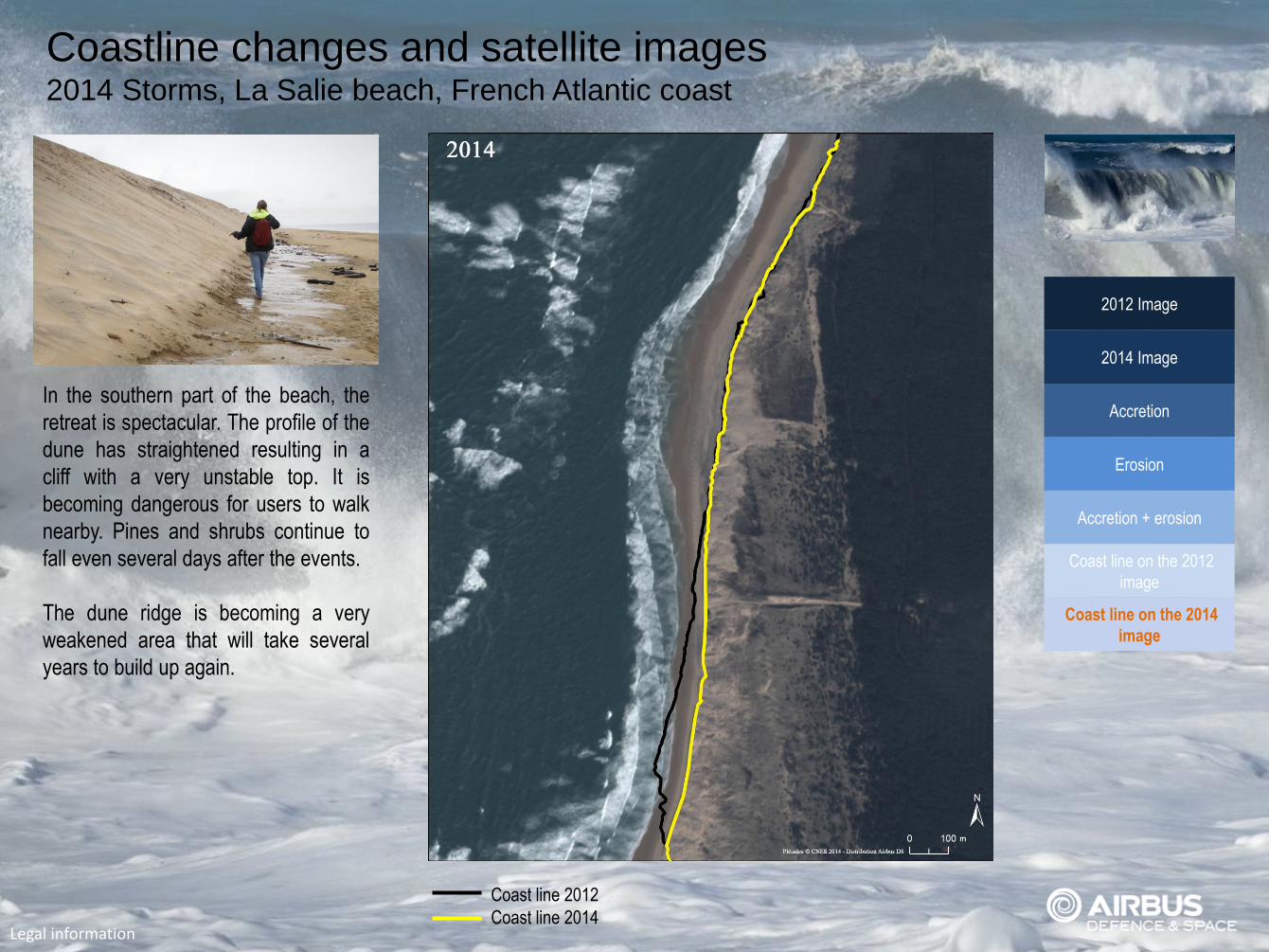
In the southern part of the beach, the
retreat is spectacular. The profile of the
dune has straightened resulting in a
cliff with a very unstable top. It is
becoming dangerous for users to walk
nearby. Pines and shrubs continue to
fall even several days after the events.
The dune ridge is becoming a very
weakened area that will take several
years to build up again.
Coastline changes and satellite images 2014 Storms, La Salie beach, French Atlantic coast
Legal information
2012 Image
2014 Image
Accretion
Erosion
Accretion + erosion
Coast line on the 2012
image
Coast line on the 2014
image
Coast line 2012
Coast line 2014

Geo Reportage Coastline Changes and Satellite Images Storms over La Salie Beach, French Atlantic Coast © Airbus Defence and Space 2015
Satellites images : Pléiades image - © CNES 2013 – 2014 – Distribution Airbus DS - Spot Image ; Photo credits : © I-Sea © Fotolia : Oscar L, Beadle, Marco Saracco, Backyardphoto, Apitsada. Design : Jean-Yves Bonzon Image processing: Denys Letourmy Graphic layout: Laurent DEMAY Texts and Publication Coordination: Pascal MICHEL
Airbus Defence and Space - Geo-Intelligence 5, rue des Satellites BP 14 359 F 31030 Toulouse cedex 4 France Téléphone : +33 (0)5 62 19 40 40 | Fax : +33 (0)5 62 19 40 11 Web: www.geo-airbusds.com | Contact Us | http://i-sea.fr/