cody region b - wgfd.wyo.gov
TRANSCRIPT

23
CODY REGION
Big Horn Basin Landcover Mapping Project (Goal 2) - Jerry AltermattA project contracted with Wyoming Geographic Information Science Center
(WyGISC) to map habitat types using satellite imagery continued into a fourth year. Sat-ellite imagery for the entire Bighorn Basin has been acquired and the Bighorn Basin has been divided into fi ve geographic priority areas for completion of mapping. The fi rst priority area was defi ned as the Absaroka Front, bound by the Shoshone National For-est on the west and roughly by the eastern boundaries of Park and Hot Springs Counties on the east. A two person crew consisting of a student intern supervised by the WGFD and a contract employee supervised by WyGISC collected vegetative cover data during the 2009 fi eld season to provide data for the completion of priority area one. Mapping of 2,420,262 acres in priority one was completed and a fi nal habitat map is scheduled to be released in early 2010. The project is being funded by WGFD Trust Fund, BLM, Big Horn Basin Sage-grouse Local Working Group, WGBGLC and State Wildlife Grants (SWG).
Clark’s Fork Aspen Enhancement (Goal 2) - Jerry Altermatt The Shoshone National Forest and WGFD conducted 50 acres of aspen treatment
in the Upper Clarks Fork drainage. The objective was to remove conifer encroachment from aspen communities at high risk of being lost through succession. The treatment conducted by a contractor and consisted of mulching smaller conifers with a masticat-ing machine and felling larger conifers with a chainsaw crew (Figure 1). The area will be treated with prescribed fi re after the needles on the felled trees turn red. The treat-ment was part of a larger project that will eventually treat 300-500 acres of aspen that was identifi ed as high priority for treatment during an inventory conducted by WGFD in 2004.
• Mechanically treated 366 acres of Russian olive and chemically treated 590 acres of Russian olive, salt cedar and Russian knapweed on the Yellowtail CRM area.
• Planted 300 cot-tonwood cuttings on the Yellowtail WHMA.
• Mechanically treated 50 acres of aspen in the Upper Clarks Fork
• 2,420,262 acres of habitat mapped by landcover.
• Planted 4,000 sage-brush seedlings into the Black Mountain wildfi re.
• Prescribed burned 100 acres of juniper in the Little Moun-tain area
• Treated 2,500 acres of cheatgrass on the Renner WHMA.
• Over 750 diversions and culverts inven-toried for the fi sh passage database.
• 12 new fi sh passage projects completed.
• Two completely dif-ferent styles of fi sh screens complete the Trout Creek project.
• Franc’s Fork road crossing gets fi sh friendly bridge.
• Darrel Mumm Fishway funded by WWNRT.

24
Bighorn Basin Resource Management Plan (Goal 1) - Jerry Altermatt The Terrestrial Habitat Biologist served as one of the WGFD’s leads on the Big-
horn Basin Resource Management Plan (RMP) revision. The BLM is revising land management plans for the old Grass Creek, Washakie and Cody Resource Areas. Under the new reorganization of the BLM a Wind River District was formed from the Cody Field Offi ce, Worland Field Offi ce and Lander Field Offi ce. The Cody and Worland Field Offi ces are combining their RMP revision efforts to produce one plan Bighorn Ba-sin RMP being analyzed with one Environmental Impact Statement (EIS) but with two NEPA decisions. WGFD personnel attended fi ve 3-day workshops and numerous other meetings with the BLM and other cooperating agencies to develop four alternatives (in-cluding the existing management) and management actions for each alternative. A draft EIS is expected for public review in 2010.
Yellowtail Area Coordinated Resource Management (Goal 1) - Jerry Altermatt The Yellowtail Area Coordinated Resource Management (CRM) team continued
to manage invasive plants on agency and private lands in the Lower Shoshone and Bighorn River corridors. The CRM consists of the four landowners on the Yellowtail WHMA (National Park Service (NPS), WGFD, BLM,and Bureau of Reclamation), neighboring private landowners, the Bighorn County Weed and Pest, NRCS, and other interested parties.
The following activities were accomplished on the CRM area in 2009:• Conducted mechanical treatments on well established Russian olive and saltce-dar using mulching machines. R & B Earthmoving, Lander, WY, was contracted to mechanically treat 235 acres of Shoshone River riparian. R & B completed treatment using a Sneller self-propelled tree and brush masticator attached to an excavator (Figure 2). CZN Corporation, Sheridan, WY, was contracted to mechanically treat 113 acres of Shoshone and Big Horn River riparian. The treatment was accomplished using two Gyro-Trac mulching machines. The NPS used a Fecon Bulldog mulching attachment on 18 acres of saltcedar. A total of 366 acres were treated, including 286 acres within the Yellowtail WHMA.
• 5.5 stream miles (100 riparian acres) of Russian olive/tamarisk mechani-cally/chemically treated on Goose-berry Creek.
• 250 willow cuttings planted on Goose-berry Creek.
• 1,488 acres of Rus-sian olive and salt cedar mechanical control completed on private land on the Nowood River.
• 1,300 willow and cottonwood cuttings and bare root seed-lings were planted along Grass Creek.
• 400 willow cuttings were planted on Kirby Creek using the waterjet stinger.
• Sunlight Basin WHMA Conifer Removal.
• Sunlight Basin WHMA Forage Uti-lization.
• Sunlight Basin WHMA bank ero-sion.
• Sunlight Basin WHMA Pole top fence upgrade.
• Sunshine WHMA Boundary fence re-location and upgrade
• Yellowtail WHMA food plots.
• Yellowtail WHMA head-gate fl ood damage repairs.
Figure 2. Mulching Russian olive on the Yellowtail CRM area.

25
• Utilized goats and cattle in prescribed grazing treatments. Boer goats were used between April and September to control invasive plants in a continuing program that was initiated in 2004. Eight areas totaling 600 acres received the grazing treatment with 1,500 goats. The primary objective is to target Russian olive, salt cedar and Russian knapweed. Monitoring studies were established to determine the effectiveness of the goat treatments. In January and February 230 head of cattle were grazed in two pastures as part of a winter graz-ing program initiated in 2002. Cattle are confi ned with electric fence to small pastures strategically located throughout the Shoshone River bottom. Pastures are designed to be no wider than ¼ - ½ mile and stretch from the river to dry upland habitat. The primary objectives of the grazing program are to reduce the risk of wildfi re by removing fi ne fuels prior to the spring wildfi re threat, rejuvenate grass/forb communities, and create areas of higher quality brood-rearing habitat for upland birds. Ice jams in the Shoshone River precluded the use of all the planned grazing pastures.• Conducted chemical treatments on noxious weeds using vehicle and backpack sprayers. Field Services, LLC from Cody, WY, was contracted to apply chemical on 528 acres of Russian olive and saltcedar re-sprouts and freshly cut stumps. Big Horn County Weed and Pest District applied chemical to 47 acres of Russian knap-weed (Figure 3). The NPS applied chemical on 15 acres of Russian knapweed and white-top. A total of 590 acres were treated within the Yellowtail CRM area.
• Continued education and public outreach efforts. The “CRM in the Classroom” program is an integrated, interdisciplinary program in which teachers and students participate in collaborative decision-making groups that are working on natural resource issues throughout the state. Lovell High School (LHS) entered into the program in 2005 and are affi liated with the Yellowtail Area CRM. During the project period 15 LHS students were involved in the following CRM projects and activities:* Russian knapweed seed viability study. Students collected knapweed seeds from goat pellets and attempted
to germinate them in the lab to determine seed viability.* Permanent vegetative trend study. Students annually read four rooted nested frequency transects to deter-
mine vegetative trend in areas grazed by cattle in the winter. Students also established or re-took fi ve photo-points to document effects of goat browsing and fi ve photopoints to document results of mechanical/chemi-cal treatment on Russian olive.
* Chemical/mechanical treatment effectiveness monitoring. Students established and read transects to deter-mine the percent mortality of chemically treated Russian olive and salt cedar.
• Planted cottonwood and willow cuttings. Over 300 cottonwood and willow cuttings were planted in areas previously treated to remove Russian olive. A waterjet stinger (Figure 4) was used to plant the cuttings. The CRM built the waterjet stinger and purchased a dedicated trailer. The stinger is owned by the Shoshone Conser-vation District and will be made available for landowners to rent.
Figure 3. Bighorn County Weed and Pest crew spraying Russian knapweed on the Yellowtail CRM area.

26
• Continued biocontrol of salt cedar. The salt cedar biocontrol program in the Yellowtail CRM using the insect, Diorhabda elongata, continues to be monitored by the Agricultural Research Station (ARS). Insect populations in 2009 appeared to dramatically decrease for unknown reasons.
The Yellowtail CRM participated in the establishment of a new CRM upstream on the Shoshone River from the Yellowtail CRM. With the establishment of the Shoshone/Clarksfork CRM, the noxious weed problem on the majority of the Shoshone River will be addressed.
Trout Creek Fish Screens (Goal 2) - Lew Stahl
Two additional screens were installed on irri-gation systems taking water from Trout Creek. In May 2009, the old irrigation headwall and headgate for the Bloom Irrigation Ditch (Fig-ure 5) was replaced with a new, concrete box structure with a headgate in the back wall of the box. The front wall of the box consists of concrete supports on the edge with a Hydrolox horizontal, traveling screen inserted to form the front wall (Figure 6). This screen (5 feet high by 8 feet long) is sized to allow the maxi-mum required irrigation fl ow to pass through unrestricted, while the 0.068 inch screen open-ings exceed NOAA fi sheries criteria of 0.069 inch openings for screening fi sh. Fish, includ-ing young-of-the-year, therefore do not leave the stream. Debris is removed from the screen by wipers at the edge of the screen structure, and by water pressure as the screen belt cycles around behind the screen framework. The screen is powered by a ¼ horse electric motor and regulated by a control box that controls on/off operation, direction of travel, speed of travel, and manual or automated operation using the included timer system. The screen operated the entire 2009 irrigation season with essentially no issues except the screen hangers on the back side of the screen rotation did not always catch on the carrier rails and a couple
Figure 4. Planting cottonwood cuttings into an area treated following removal of Russian olive.
Figure 5. Old Bloom irrigation structure.
Figure 6. New irrigation structure with horizontal fi sh screen.

27
of polyethylene strips came off the carrier rails near season’s end. The screen was removed for maintenance in November 2009 and a screen evaluation by Hydrolox engineers was also completed. Upgrades were installed in December 2009 by Hydrolox Engineers and WGFD personnel with assistance from a local welding shop. The WGFD paid for the time and equipment to remove and haul the structure, but Hydrolox paid for all the upgrades and welder time.
The second screen installed in the Trout Creek Lateral Ditch in November of 2009 was a Farmers Screen from the Farmers Conservation Alliance. It is a bottom-oriented fl at plate screen installed directly into the irrigation ditch, with a bypass pipe returning fi sh and debris back to Trout Creek (Figures 7 and 8). The screen is stainless steel punched plate with 50% porosity and openings meeting NOAA criteria for young-of-the-year fi sh. Wa-ter fi ltered by the screen passes downward through the screen until the water depth rises and water fl ows over the weir wall to the opposite side of the screen box, and then continues downstream into the irrigation system (Figure 9). Fish and small debris remain on top of the screen, fl ow out the end of the structure into a bypass pipe, and back to Trout Creek. There are no moving parts to this screen. Although entrained fi sh are temporar-ily held in the ditch, the structure was placed as close to the headgate as the ditch slope would allow, so fi sh will be returned to the stream within a short distance. Although the screen was installed after the irrigation season, water was run through the screen to evaluate function. Leaves and grass were effi ciently screened from the ir-rigation fl ows, cleaned from the screen surface, and returned to the creek though the bypass pipe. This indicated the screen will be ready to operate during the 2010 irrigation season.
Figure 9. Fish and bypass water return to the stream from the right side of the structure, while water passing through the screen to the left side fl ows to the irrigation ditch.
Figure 7. Overhead view of the new Farmers Screen installed in the Trout Creek Lateral Ditch.
Figure 8. Fish and debris return to Trout Creek through this bypass pipe.

28
Franc’s Fork Barrier Replacement (Goal 2) - Lew Stahl The Franc’s Fork road crossing was a fi sh barrier for several reasons. The main road culverts produced
high water velocities during migration periods, the concrete apron downstream of the culverts was fl at, smooth and perched above the streambed, and the high fl ow relief culverts were often plugged with debris, stopping any passage through these tubes (Figure 10). The Department provided a fi sh passage grant to TU to replace the road crossing with a new free-span bridge in late fall of 2009 (Figure 11). Additional fi ne tuning and vegetation planting is scheduled for spring 2010.
Darrel Mumm Fishway (Goal 2) - Lew StahlThe Sidon Canal crosses Bitter Creek is a large concrete box culvert that becomes a barrier to fi sh moving
upstream from the Shoshone River to spawning sites in upper Bitter Creek. A preliminary design was evaluated and a fi nal design nears completion for a bypass chute channel that will allow fi sh to swim upstream into the chute, travel into the uplands while gaining elevation, and back to the top of the box structure, where fi sh will return to the main channel. Funding has been obtained from the Wyoming Wildlife and Natural Resource Trust Fund, U.S. Fish and Wildlife Service, Game and Fish Department Habitat Trust Fund and M&O funds. The project is scheduled for the fall of 2010.
Little Mountain Prescribed Burns (Goal 2) - Jerry Altermatt Approximately 100 acres of juniper communities were treated with prescribed fi re in the Little Mountain
area east of Lovell. The objectives of the treatments were to remove encroaching junipers from sagebrush communities within elk, mule deer and sage grouse habitat. The burns were conducted by the BLM Cody Field Offi ce with assistance from WGFD. The burns were part of a larger effort that has treated over 3,000 acres in the Little Mountain area.
Black Mountain Sagebrush Restoration (Goal 2) - Jerry Altermatt In November, 4,000 sagebrush seedlings were planted within the 50,000 acre Black Mountain wildfi re
southeast of Worland. The wildfi re burned large areas of Wyoming big sagebrush that served as pronghorn and mule deer winter range as well as breeding, nesting and winter range for sage-grouse. The objective of the proj-ect is to establish seed sources within the burn by creating group plantings of sagebrush in select areas. Sage-brush seed was hand collected near the project by BLM and WGFD personnel in 2008 and grown by Great Bear Restoration, a nursery in Montana. The 10-inch tublings were planted in groups of approximately 80 plants and enclosed by 8 square foot cages to exclude browsing by livestock and wildlife (Figure 12). In half of the group plantings, weed barrier was used to reduce competition from cheatgrass. Sugar was spread on the remaining group plantings to inhibit cheatgrass growth by reducing the nitrogen/carbon balance. A BLM fi re engine and crew were on hand to water the plants (Figure 13) . Plans are being made to conduct large scale cheatgrass spray treatments in the area in 2010 and 2011.
Figure 10. Fish barrier not permitting upstream fi sh passage. Figure 11. New fi sh friendly bridge allows upstream fi sh passage.

29
Renner Cheatgrass Control (Goal 1) - Jerry AltermattApproximately 2,500 acres of cheatgrass dominated rangeland on the Renner WHMA was aerially sprayed
with Plateau herbicide (Figure 14). The treatment was contracted with Wyoming Helicopter of Boulder, WY. The treatment included 1,500 acres treated with a six ounce rate of herbicide and 5 gallons of total volume per acre in the South Pasture and 1,000 acres treated with a eight ounces of herbicide and 10 gallons of total vol-ume per acre in the Lower Mountain Pasture. The Lower Mountain Pasture was previously treated in 2008, but control of cheatgrass was very poor due to emergence of cheatgrass prior to the herbicide application. BASF donated the chemical to retreat these acres. The Lower Mountain pasture is important for wintering elk and the South pasture contains mule deer winter range and sage grouse breeding habitat.
Figure 12. Planting crews planting sagebrush seedlings in the Black Mountain wildfi re area.
Figure 13. BLM fi re crew member watering in sagebrush seedlings.
Figure 14. Helicopter leaving the tender truck during the Renner Cheatgrass Control project.

30
Production/Utilization Surveys (Goal 2) - Jerry Altermatt Regional wildlife personnel collected production utilization data at nine sagebrush transects during 2009
(Figure 15). Production of sagebrush averaged over all transects was slightly below the 6-year average. Trans-acts on the west slope of the Bighorn Mountains were above average, while those on the face of the Absaroka Mountains were below. Utilization at all transects in spring 2009 was below average and was well below the 35% threshold (Figure 16). This may be due in part to the excellent production in 2008. Light utilization may indicate that populations are in balance with the amount of winter forage, but may also refl ect the fact that the Cody Region has experienced mild winters with big game distributed more widely over winter ranges rather than concentrating animals on crucial winter ranges where utilization studies are located.
Figure 15. Annual production of sagebrush at ten locations in the Cody Region.
Figure 16. Utilization of sagebrush expressed as percent of that years annual leaders browsed at ten locations in the Cody Region.

31
Kirby Watershed Wildlife Habitat Enhancement Project (Goal 2) - Amy AndersonThe Kirby Creek CRM group is continuing to plan and implement projects that focus on restoring ecologi-
cal functions within the watershed. Existing Continuous Conservation Reserve Program (CCRP) projects on Kirby Creek are showing a tremendous vegetative response and are providing quality habitat for beaver, mule deer, sage grouse, and migratory songbirds. 400 willow cuttings were planted on one CCRP area using the wa-terjet stinger, and in early July survival was very high. However, by late July and August grasshopper damage to the willows was extreme, and survival may ultimately be low. Additional CCRP projects are currently under-way, and were partially funded through the WGFD WyWHIP incentive program. The Kirby Watershed Wildlife Enhancement Project is being expanded to restore riparian habitat and stream form and function and improve range conditions within the 250,000-acre Kirby Creek drainage. Work thus far has focused on removal of graz-ing pressure on riparian areas, extensive water development, removal of invasive Russian olive and salt cedar, and experimental weed control of white-top. A large project has been initiated to install in-stream structures to slow water velocity and decrease the massive erosion events that are occurring at Stan’s Folly along Kirby Creek. A grant was approved by WWNRT to fund this series of structures. NRCS engineers completed the design for the structures during the summer of 2009, and construction will begin early in the summer of 2010. In the uplands, three ponds were constructed to capture run-off, slow erosion, and to create watering sources for livestock and wildlife. Also, a 2,000 foot pipeline with six water tanks was installed to improve grazing distribution. Cooperators for all projects on Kirby Creek include WGFD, BLM, NRCS, Department of En-vironmental Quality (DEQ), Wyoming Water Development Commission (WWDC), Hot Springs County Weed and Pest, Hot Springs County Conservation District, and private landowners. Total project cost for this drainage thus far is $1,492,160, excluding a portion of new contracts. The primary funding sources for this watershed include DEQ 319 funds, CCRP, WWNRT, Hot Springs County Weed and Pest, WGFD, NRCS - Environmental Quality Incentive Program (EQIP), WWDC, Private Grazing Lands Initiative, and private landowners.
Nowood River Riparian Enhancement Project (Goal 2) - Amy AndersonIn November of 2007, a project was initiated to begin work to improve the riparian areas within the No-
wood River Watershed. A total of 25 contracts have been initiated to control Russian olive and salt cedar on over 2,500 acres within the 1,287,000 acre Nowood Watershed. These contracts are for the single practice of Pest Management- initial control of Russian olive and salt cedar- however, all landowners are encouraged to implement managed grazing of riparian areas, and re-establishment of native woody species through future farm bill contracts or technical assistance. To date, a total of 2,612 acres have had a mechanical treatment and a follow-up chemical treatment. The primary funding source for this project thus far is USDA AMA funds. Ad-ditional funding was acquired through WWNRT in the amount of $115,000. 1,488 acres were mechanically and chemically treated in 2009 (Figures 17 and 18). Many of the landowners on the Nowood have chosen to
Figure 17. Nowood River private land in 2008 before Russian olive and tamarisk control.
Figure 18. After Russian olive and tamarisk treatment in 2009.
32
complete the work themselves rather than hire contractors. In doing so, the landowners have taken full owner-ship of the project and will likely put forth efforts to maintain the work they have completed. However, costs are signifi cantly higher on many of these properties where landowners are doing control work by hand, as op-posed to the costs when a contractor is hired. To date, the total project cost is: $621,373. Cooperators for this project include: NRCS, WGFD, WWNRT, Washakie County Conservation District, Big Horn County Conser-vation District, Washakie County and Big Horn County Weed and Pest, and private landowners.
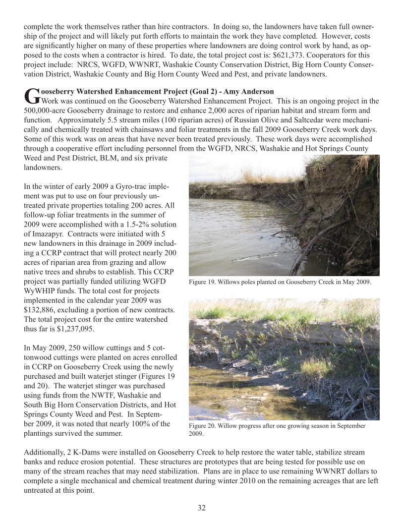
Gooseberry Watershed Enhancement Project (Goal 2) - Amy AndersonWork was continued on the Gooseberry Watershed Enhancement Project. This is an ongoing project in the
500,000-acre Gooseberry drainage to restore and enhance 2,000 acres of riparian habitat and stream form and function. Approximately 5.5 stream miles (100 riparian acres) of Russian Olive and Saltcedar were mechani-cally and chemically treated with chainsaws and foliar treatments in the fall 2009 Gooseberry Creek work days. Some of this work was on areas that have never been treated previously. These work days were accomplished through a cooperative effort including personnel from the WGFD, NRCS, Washakie and Hot Springs County Weed and Pest District, BLM, and six private landowners.
In the winter of early 2009 a Gyro-trac imple-ment was put to use on four previously un-treated private properties totaling 200 acres. All follow-up foliar treatments in the summer of 2009 were accomplished with a 1.5-2% solution of Imazapyr. Contracts were initiated with 5 new landowners in this drainage in 2009 includ-ing a CCRP contract that will protect nearly 200 acres of riparian area from grazing and allow native trees and shrubs to establish. This CCRP project was partially funded utilizing WGFD WyWHIP funds. The total cost for projects implemented in the calendar year 2009 was $132,886, excluding a portion of new contracts. The total project cost for the entire watershed thus far is $1,237,095.
In May 2009, 250 willow cuttings and 5 cot-tonwood cuttings were planted on acres enrolled in CCRP on Gooseberry Creek using the newly purchased and built waterjet stinger (Figures 19 and 20). The waterjet stinger was purchased using funds from the NWTF, Washakie and South Big Horn Conservation Districts, and Hot Springs County Weed and Pest. In Septem-ber 2009, it was noted that nearly 100% of the plantings survived the summer.
Additionally, 2 K-Dams were installed on Gooseberry Creek to help restore the water table, stabilize stream banks and reduce erosion potential. These structures are prototypes that are being tested for possible use on many of the stream reaches that may need stabilization. Plans are in place to use remaining WWNRT dollars to complete a single mechanical and chemical treatment during winter 2010 on the remaining acreages that are left untreated at this point.
Figure 19. Willows poles planted on Gooseberry Creek in May 2009.
Figure 20. Willow progress after one growing season in September 2009.

33
NRCS AMA funding has been the primary funding source for this project thus far. Other funding sources include Farm Services Agency (FSA) CCRP funds, WWNRT, NRCS EQIP, Washakie County and Hot Springs County Weed and Pest Districts, WGFD, BLM, Washakie County Conservation District, WGBGLC, State Lands, and private landowners
Cottonwood/Grass Creek Watershed Improvement Project (Goal 2) - Amy Anderson In August of 2007 steps were taken to begin working actively on the salt cedar and Russian olive invasion
on Cottonwood Creek. A CRM/WID (Watershed Improvement District) has been in place since 2005, and large tracts of the 270,000 acre watershed have been inventoried for all noxious and invasive weed species through individual and Hot Springs County Weed and Pest efforts. A Weed Management Area has been in effect on Grass Creek since 2005, and is highly effective at fi nding and treating infestations of all weed species on the Grass Creek portion of the watershed. To date, 275 acres of Cottonwood Creek were treated mechanically with follow up chemical treatments. In January 2010 mechanical control of mainly salt cedar began on 800 acres of private land signed up under the NRCS AMA Program and 75 acres of BLM land. Currently, the largest fund-ing source for this project is the NRCS AMA Program followed by the WWNRT which has allocated $225,000 to the project. The Nature Conservancy obtained an additional $40,000 to assist with this effort, especially on BLM land bordering the project area. Every landowner with property adjacent to Cottonwood Creek has initi-ated efforts to control saltcedar and Russian olive. Cooperators include: First and foremost the private land-owners, USDA/NRCS, WGFD, Washakie and Hot Springs County Conservation Districts, Hot Springs and Washakie County Weed and Pest, Cottonwood/Grass Creek Watershed Improvement District, BLM, The Nature Conservancy (TNC), Wyoming State Lands and Investments, and Wyoming State Forestry.
In May of 2009, several work days were held to plant willow and cottonwood cuttings using the waterjet stinger (Figures 21 and 22). Over 1,300 willows, cottonwoods, and bare root seedlings were planted on 3 different properties. By September 2009, it was noted that survival of the willows was nearly 100%, but the cottonwood cuttings had a much lower survival, less than 20%.
Figure 21. Volunteers planting willows using the waterjet stinger on Grass Creek.
Figure 22. Volunteers planting cottonwood seedlings and cuttings on Grass Creek.

34
Greybull River Watershed Enhancement Project (Goal 2) - Amy AndersonThe Greybull River Russian olive and tamarisk control project began in 2008. 692 acres of Russian olive
and tamarisk were treated in 2009 by fi ve different landowners. The WWNRT approved a grant of $300,000 to assist landowners with this project. Project costs are approximately $123,182, excluding individual landowner efforts and in-kind contributions.
Shoshone/Clark’s Fork Watershed Enhancement Project (Goal 2) - Amy AndersonThe Shoshone/Clark’s Fork Russian olive and tamarisk control project was initiated in the fall of 2008 with
a single WHIP contract. The interest within the watershed has increased exponentially since that time, and it will continue to do so as more areas get cleared. In the summer of 2009 several meetings were held and a CRM was formed by landowners within the watershed. Many agencies have stepped forward to offer help, and WWNRT contributed $300,000 to this project. To date, 110 acres have been treated using NRCS AMA funds and private landowner contributions (Figures 23 and 24).
Figure 23. Shoshone River Russian olive control treatment being completed in February 2009.
Figure 24. Shoshone River vegetation response post Russian olive control August 2009.

35
The Enos Creek Conifer Control Project (Goal 2) - Amy Anderson The Enos Creek conifer control project was initiated in late 2008 by the BLM Worland Field Offi ce (Fig-
ures 25 and 26). Within the Enos Creek drainage, juniper and limber pine are encroaching heavily in the ri-parian corridor, as well as into the upland deep soiled range sites that would normally contain big sagebrush stands. Nearly all of the big sagebrush stands in the drainage exhibit active juniper encroachment typical of the Bighorn Basin. 1,117 acres of private and BLM land will have vegetation treatments conducted over the next several months. In the summer of 2009, a BLM fuels crew worked using chainsaws and a timber-axe imple-ment mounted on a skid steer to clear 328 acres of juniper, limber pine, and decadent sagebrush plants from the riparian area of Enos Creek. In 2010, the secondary terrace along Enos Creek will have juniper and limber pine control treatments conducted by the BLM. The WWNRT contributed $100,000 to this effort, and a NRCS WHIP contract was initiated to assist with follow-up riparian enhancement practices such as small check dams to improve hydrology. WGFD fi sheries personnel stocked Enos Creek in 5 of the last 10 years.
Sunlight Basin WHMA Conifer Removal - Steve Ronne This project was designed to stimulate production of willow, aspen, grasses, forbs and shrubs to benefi t elk,
moose, deer, and other species of wildlife. Conifer encroachment has caused deterioration of aspen and willow communities. Mature and now mostly beetle killed spruce stands have greatly reduced or eliminated under-story vegetation. By changing the seral stage it is expected to stimulate growth of other plant species which are more desirable to wildlife. By removing the continuous closed canopy forest wildfi re risk will be reduced. It is also expected that by removing conifers, water transpiration will be reduced to raise ground water levels and promote willow and aspen regeneration in the area. Photo points and exclosure cages have been established to monitor vegetative change (Figures 27 and 28).
Figure 25. Landscape view of Enos Creek before conifer control.
Figure 26. Enos Creek conifer control within the riparian zone.
Figure 27. Before conifer removal Sunlight Basin WHMA. Figure 28. After conifer removal Sunlight Basin WHMA.

36
Sunlight Basin Bank Erosion - Steve Ronne Over bank-full fl ows and prolonged runoff cou-
pled with saturated soils severely eroded a high bank and undercut the irrigated meadows. Repairs to the existing stream revetment and terracing of the high bank will be done spring 2010 to mitigate further loss of meadow, topsoil, a power line, and the road (Fig-ure 29).
Sunshine WHMA Boundary Fence Upgrade - Steve Ronne
6,600 feet of three-wire hi-tensile electric fence was installed. In cooperation with USFS and adjacent private land owners the west boundary fence was relocated from a very steep area to a more favorable location. Several large metal gates were also installed at areas of heavy big game movement. The old four wire stock fence was removed by the contractor.
Yellowtail WHMA Food Plots - Steve RonneApproximately 69 acres of cover fi elds were mowed to a height of 8” to stimulate new growth and produc-
tion. As part of a multi-year project to rebuild the soils of a 19 acre fi eld, it was mowed to promote seed dis-persal, disked, and then inter-seeded with a sorghum/sudan-grass mix. The purpose of these fi elds is to provide pheasant and duck nesting cover as well as hunting opportunity for pheasant hunters.
Sunlight Basin WHMA Forage Utilization - Steve RonneDue to heavy spring snows and abundant summer rainfall forage production was the highest seen in many
years. The meadows were fertilized in 2004, so production shown that year is higher than average. The trend at Sunlight Basin WHMA is for fewer elk utilizing the meadows for a shorter period of time (Figures 30, 31, 32, and 33).
Figure 29. Bank erosion and road damage at Sunlight basin.

37
Figure 32. Sunlight Basin WHMA non-meadow production
Figure 33. Sunlight Basin WHMA non-meadow utilization.
Figure 31. Sunlight Basin WHMA meadow utilization.

38
Sunlight Basin WHMA Pole Top Fence - Steve Ronne Over one mile of old four-strand barb wire fence was replaced with two wire pole top with metal gates
(Figure 34). The result will be easier big game passage and less fence maintenance.
Yellowtail WHMA Headgate Flood Damage Repairs - Steve RonneMuch higher than normal fl ows caused the Shoshone River to go outside the banks in late spring/early
summer (Figure 35). Average fl ows are 1,200 cfs, and in June 2009 fl ows reached record levels of 8500 cfs, causing water to fl ow over the main head-gate and erode the road bed of State Highway 37. Wyoming Depart-ment of Transportation (WYDOT) breached the canal downstream to reduce the damage to the highway. Once the fl ood waters subsided WYDOT employees, private landowners, and Habitat and Access employees hauled approximately 2,000 cubic yards of material to repair the damage done to the head-gate headwall, road bed and canal bank. WYDOT responded to assist with repairs immediately, and a neighboring landowner provided his time and a front end loader to load dump trucks hauling fi ll material.
Figure 34. Installation of pole top fence Sunlight Basin WHMA.
Figure 35. Flood damage at the Yellowtail irrigation main supply head-gate.