coeur d'alene river wildlife management area - idaho fish and game
TRANSCRIPT
COEUR D'ALENE RIVER Wildlife Management Area
Management Plan July 1999
Idaho Department of Fish and Game Panhandle Region
2750 Kathleen Avenue Coeur d'Alene, Idaho 83815
Prepared By: John Nigh, Regional Habitat Biologist
Paul Hanna, Regional Habitat Manager
i
TABLE OF CONTENTS
TABLE OF CONTENTS ................................................................................................................. i
LIST OF TABLES .......................................................................................................................... ii
LIST OF FIGURES ......................................................................................................................... ii
FOREWORD .................................................................................................................................. 1
INTRODUCTION........................................................................................................................... 2 LOCATION ........................................................................................................................ 2 PURPOSE AND MANAGEMENT APPROACH ............................................................. 2
HISTORICAL PERSPECTIVE ...................................................................................................... 2 HISTORY ........................................................................................................................... 2 ACQUISITION ................................................................................................................... 5
DESCRIPTION OF RESOURCES ................................................................................................ 6 GEOGRAPHIC FEATURES AND CLIMATE ................................................................. 6 VEGETATION ................................................................................................................... 6 WATERFOWL ................................................................................................................... 7 BIG GAME ......................................................................................................................... 8 OTHER GAME SPECIES .................................................................................................. 8 FURBEARERS ................................................................................................................... 8 NON-GAME WILDLIFE ................................................................................................... 8 FISHERIES ......................................................................................................................... 9
PUBLIC USE .................................................................................................................................. 9
MANAGEMENT GOALS AND ONGOING ACTIVITIES .......................................................... 9
ISSUES, OBJECTIVES AND STRATEGIES ............................................................................. 11
APPENDIX A ............................................................................................................................... 23 LAND AND WATER CONTROL ................................................................................... 23
APPENDIX B ............................................................................................................................... 26 DEVELOPMENT HISTORY ........................................................................................... 26
ii
LIST OF TABLES
Table 1. Ducklings observed during brood counts on the Coeur d’Alene River WMA since 1992............................................................................................................................. 17
Table 2. Canada goose goslings transplanted to the Coeur d’Alene River WMA since 1987. 17
Table 3. Canada goose nests observed on the Coeur d’Alene River WMA since 1989. .......... 18
Table 4. Wood duck next box surveys on the Coeur d’Alene River WMA since 1989. .......... 18
Table 5. Comparison of ingested lead and steel shot in hunter-harvested duck gizzards from the Coeur d’Alene River WMA since 1988. ...................................................... 19
Table 6. Status of Coeur d’Alene River (Killarney Lake) bald eagle nest since 1992. ............. 19
Table 7. Status of Anderson Lake bald eagle nest since 1994. ................................................. 20
Table 8. Osprey nest surveys on the lower Coeur d’Alene River since 1989. .......................... 20
Table 9. Osprey nest surveys on the lower St. Joe River since 1989a. ...................................... 21
Table 10. Public use estimates on the Coeur d’Alene River WMA. .......................................... 21
Table 11. Opening weekend waterfowl check station results on the Coeur d’Alene River WMA since 1988. ....................................................................................................... 22
LIST OF FIGURES Figure 1. Map of Coeur d’Alene River WMA - Coeur d’Alene River Segment. ........................ 3
Figure 2. Map of Coeur d’Alene River WMA - Round Lake Segment. ...................................... 4
1
FOREWORD
A key element of wildlife management in Idaho involves managing land and water - the habitat base required for all fish and wildlife species. Providing public access for hunting, fishing, trapping or simply viewing wildlife is also an integral part of this state’s wildlife management program. In order to provide habitat for fish and wildlife species and public access, the Idaho Department of Fish and Game (Department) has developed a system of Wildlife Management Areas on Department-owned or managed lands throughout the state. This document is the plan for the Coeur d’Alene River Wildlife Management Area (WMA) in Kootenai and Benewah counties and replaces the previous plan adopted in 1985. The plan supplements the Department’s Policy Plan 1990-2005: A Vision For The Future. The reason for this planning effort is to ensure long-term protection and management of fish and wildlife resources on Department property within biological limits, economic, social and manpower constraints. Management goals have been identified as well as those issues the Department believes could affect achieving the stated goals and ongoing management activities. Finally, objectives and strategies are proposed to deal with these issues. Data used in this plan were those available through the summer of 1998. This plan should be viewed as a guideline for land and resource management decisions that will periodically be subject to change as new data regarding fish and wildlife resources, hunters, anglers, and other segments of the public become available. An open house scoping session was held in Medimont on March 7, 1996, asking the public to assist the Department in identifying issues that needed to be discussed in formulating the Coeur d’Alene River WMA Plan. A second open house was held in Medimont on December 10, 1996, asking the public to assist the Department in formulating objectives and strategies to address issues previously identified. Public participation was invited by paid advertisements in local newspapers and flyers posted at local businesses in communities located within Kootenai, Benewah, and Shoshone counties. Personal letters were mailed to over 90 individuals, groups, government entities and elected officials with a stake in the future of the WMA.
2
INTRODUCTION Location
The Coeur d’Alene River WMA is located primarily in Kootenai County within the lower Coeur d’Alene River Valley and extends from the mouth of the Coeur d’Alene River at Harrison upstream to Cataldo, a distance of 25 miles (Figure 1). A detached portion of the WMA, referred to as the Round Lake segment, is located at the southern end of Coeur d’Alene Lake near the mouth of the St. Joe River in Kootenai and Benewah counties (Figure 2). Purpose and Management Approach
The WMA was created to protect and enhance waterfowl habitat, increase waterfowl production, and provide a secure staging area for migrating waterfowl. An important aspect of the WMA is providing public access for waterfowl and big game hunting, fishing, and wildlife viewing. Habitat management and development emphasis has primarily been for waterfowl production; maintenance of stable water levels through a series of dikes and water control structures; introduction of wild rice as a food source; and creating islands and open water in dense stands of horsetail rush. Water levels on Coeur d’Alene Lake and the WMA are controlled by a dam on the Spokane River at Post Falls that is owned and operated by the Washington Water Power Company (WWP). WWP maintains stable water levels from June through September at an elevation that provides nearly optimum conditions for most of the marshlands on the WMA. However, beginning in late September, the lake is drawn down seven feet for power generation, reaching low pool by mid-December. Fish and wildlife carrying capacities are reduced in those lakes and wetlands that do not have dikes and water control structures to retain water at or near full pool elevation. The Department has been granted water rights licenses to impound water and control water levels in many of the wetlands on the WMA to provide maximum benefits for fish and wildlife resources.
HISTORICAL PERSPECTIVE History
The lower Coeur d’Alene River Valley was originally developed by farmers and loggers. Mining towns were established on the North Fork and South Forks of the Coeur d’Alene River after the discoveries of gold, silver, and lead. After settlement by the white man, the river became a transportation corridor. Steamboats carried freight and passengers to the upper limit of navigation at Cataldo and ore was carried on the return trip. The era of steamboats ended when the Union Pacific Railroad and a road system were constructed into the Silver Valley.
3
COEUR D’ALENE RIVER WMA MAP
COEUR D’ALENE RIVER SEGMENT
Figure 1. Map of Coeur d’Alene River WMA - Coeur d’Alene River Segment.
4
COEUR D’ALENE RIVER WMA MAP
ROUND LAKE SEGMENT
Figure 2. Map of Coeur d’Alene River WMA - Round Lake Segment.
5
The lower river floodplain has a history of significant mining related pollution dating back to the 1880's. The entire floodplain, including all wetlands and lakes, has a deep sediment layer that contains a large amount of water borne mine wastes contaminated by heavy metals, primarily lead, cadmium, and zinc. Pollution control efforts by the mining industry have improved considerably over the past 100 years but the river system continues to move contaminated sediments downstream during annual flood events. The average lead content of sediments throughout the river floodplain is estimated at 2,500 parts per million. During the 1920's and 1930's the Coeur d’Alene River was reported to be toxic enough that most aquatic life could not survive. Dead tundra swans were reported as early as 1924. Waterfowl deaths, primarily swans and Canada geese, have frequently occurred during the spring migration since the 1920's and continue to the present. Most of the mortalities have been due to lead poisoning from ingesting contaminated sediments. The construction of Post Falls Dam in 1906 and subsequent improvements in the 1940's impounded Coeur d’Alene Lake backing water up the Coeur d’Alene River to Cataldo and up the St. Joe River to St. Joe City. Operation of the dam has disrupted the natural rise and fall of the lake and stabilizes water at a higher level from the spring run-off through September. Much of the low-lying land adjacent to the lower Coeur d’Alene and St. Joe rivers was rendered unusable for farming due to the higher water level throughout the growing season. Acquisition
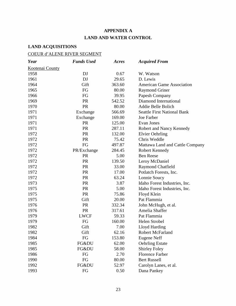
Acquisition of the WMA began in 1964 with a gift of 364 acres from the American Game Association at Killarney Lake. The Department authorized an aggressive expansion program primarily using Pittman-Robertson funding and Fish and Game license dollars and acquired 34 additional parcels in Kootenai County and four in Benewah County. The latest acquisition was completed in 1993. Other funding sources also used for acquisition included Dingell-Johnson funding, the Land and Water Conservation Fund, and the Ducks Unlimited MARSH program. Currently the Department owns 5,671 acres, primarily marshlands - 5,065 acres in Kootenai County and 606 acres in Benewah County. The Department has water rights licenses for 5,719 acre-feet of reservoir storage on 1,650 surface acres in the lower Coeur d’Alene River Valley in Kootenai County. In addition to property owned in fee title, the Department leases 592 acres from the Idaho Department of Lands; 250 acres from WWP at Round Lake; and 80 acres from WWP near Rose Lake. The Department also has cooperative management agreements with the US Forest Service and the Bureau of Land Management for 722 wetland acres near Rose Lake, Killarney Lake, and Thompson Lake. Appendix A outlines the Department’s acquisition of the WMA. Appendix B contains a brief listing of developments and management actions on the WMA undertaken by the Department since 1971.
6
DESCRIPTION OF RESOURCES Geographic Features and Climate
The most prominent features on the Coeur d’Alene River segment of the WMA are the lower Coeur d’Alene River and the associated lateral lakes and marshlands in the river floodplain. The Coeur d’Alene River flows from east to west through a broad floodplain ranging from 1/4 to 1 3/4 miles in width and drains into Coeur d’Alene Lake at Harrison. The WMA encompasses all or portions of thirteen small to moderate-sized shallow lakes (<25' deep) and an extensive network of marshlands. Most of the lakes are connected to the river by surface channels that have been deepened or widened by dredging in the past. The most prominent features on the Round Lake segment of the WMA are the southern end of Coeur d’Alene Lake, Round Lake, and the mouth of the St. Joe River. The “River that flows through the Lakes” is a unique feature of the lower St. Joe River. Here the river flows between two natural levees that are surrounded by Benewah, Chatcolet, Round, Hidden, and Coeur d’Alene lakes. The WMA has a typical Pacific Northwest climate - warm, dry summers and cold, wet winters. The annual precipitation ranges from 25-30". Over 60% of the precipitation falls from October through March primarily as snow. Rain-on-snow events in the Coeur d’Alene River and St. Joe River drainages occur annually. Prolonged rain-on-snow events can cause significant flooding in low-lying areas. Flooding can raise water levels 7-10 feet over the normal high water mark and may occur several times a year. Vegetation
Typical aquatic vegetation found in WMA wetlands includes pond weed, arrowhead, cattails, bulrushes, sedges and horsetail rush. Wild rice has been introduced into most wetlands on or near the WMA during the past 50 years. It now occurs primarily in wetlands surrounding Killarney Lake and in lakes on both sides of the St. Joe River near its mouth. Several thousand pounds of wild rice seed are harvested by the Department annually near Killarney Lake. Seed has been provided to local landowners, other resource agencies, and Indian tribes throughout Idaho and the western United States. The WMA has three significant peatland sites located at Rose Lake, Hidden Lake, and Thompson Lake. Peatlands are generally defined as wetlands with waterlogged substrates and at least 30 cm. of peat accumulation. All three WMA peatlands have extensive floating and fixed mats along the lake margins that provide substrates for a mosaic of mosses, sedges, pink spirea, cattails, rushes, alder and willows. Portions of the Hidden Lake site are dominated by cranberry, a non-native shrub introduced by former land owners in the 1930's. Rare plant species associated with the WMA’s peatlands include swamp willow-weed, water clubrush, many-fruit false loosestrife and watery celery.
7
Riparian zones within the floodplain are dominated primarily by hardwoods, brush and grasses. Typical tree and shrub species include black cottonwood, birch, pink spirea, willows, red-osier dogwood, and red alder. Common grasses include reed canary grass and red top. WMA upland areas out of the floodplain are covered primarily by conifers and some hardwoods. Conifer stands include lodgepole pine, ponderosa pine, Douglas fir, grand fir, western larch, and western white pine and are often mixed with black cottonwoods, quaking aspen, birch, and red alder. Waterfowl
The entire WMA is an important area for waterfowl. It serves as a production area for local birds and a major feeding and resting area for both spring and fall migrants. The greatest waterfowl use of the WMA occurs during the fall migration. Maximum counts during aerial flights have been as high as 20,000 ducks, 2,000 geese, and 200 tundra swans. Common migrants include mallards, American widgeon, pintails, Canada geese, and tundra swans. The WMA also provides important breeding and nesting habitat for waterfowl primarily mallards, green-winged teal, wood ducks, and Canada geese (Table 1). Prior to 1980, no Canada goose production was recorded on the lower Coeur d’Alene River. Because of extreme water fluctuations during spring flooding, ground-nesting geese were apparently unable to nest successfully. In an attempt to start a local nesting population, the Department began placing artificial nest platforms and transplanting goslings. As many as 285 elevated nesting platforms have been erected and over 1,100 goslings transplanted (Table 2). The program has been successful. Since 1989, the number of goose nests counted on the WMA has increased over 60% (Table 3). The WMA provides habitat for one of the larger breeding populations of wood ducks in the Northwest. Wood ducks are cavity nesters and dependent on naturally occurring cavities or cavities excavated by woodpeckers in large trees for nest sites. Large cottonwood trees found on the WMA are especially important. Approximately 400 man-made nesting boxes have been maintained throughout the WMA to provide artificial cavities for nesting wood ducks to use. Since 1989, 40% of the nest boxes have been used by wood ducks annually (Table 4). A significant portion of the waterfowl hunting in northern Idaho occurs on the WMA each fall. Hunting is excellent for ducks early in the season. If the weather is mild, good hunting for ducks and Canada geese continues through November. Migrating mallards stop at areas with wild rice, utilizing it as a principal food source. In 1984, a study of hunter-harvested ducks taken on the WMA revealed that 29% of the gizzards contained at least one ingested lead shot pellet. Due to the nationwide concern over lead poisoning in ducks from spent lead shot, the WMA was designated a steel-shot zone in 1986. Gizzards have been collected annually since 1984 and the incidence of ingested lead shot has declined but it is still readily available after thirteen years (Table 5).
8
Canada goose band recovery information for goslings transplanted to the Coeur d’Alene River WMA since 1989 indicates 18 percent of all banded geese have been taken and reported by hunters representing eleven states and three Canadian provinces. Forty-five percent of all returns came from geese shot in Idaho, primarily in the five northern counties. Since 1989 the mean direct recovery rate of transplanted goslings has been 8.4 percent. Big Game
Common big game species on the Coeur d’Alene River WMA include white-tailed deer, elk, and black bear. White-tailed deer are the most numerous, occupying the WMA year-round. Elk use of the WMA occurs primarily in the winter and spring. Elk are most visible during green-up in March on south-facing slopes above the river. Black bear are frequently observed in late spring - early summer feeding on new grasses. Moose, mule deer and mountain lion are occasional WMA visitors. Big game hunting for white-tailed deer, elk, and black bear occurs throughout the WMA and is popular with local residents. Other Game Species
Ruffed grouse , common snipe, mourning doves, snowshoe hares, and American coots are all common game species on the WMA. Merriam’s turkeys are frequent visitors. Furbearers
Muskrats, mink, beaver, raccoons, and weasels are common. Muskrat pushups and beaver lodges make excellent waterfowl nest sites. However, few ground nests survive the normal spring flood except in marshes protected by dikes. Trapping interest on the WMA has declined in recent years due to low fur prices. Non-Game Wildlife
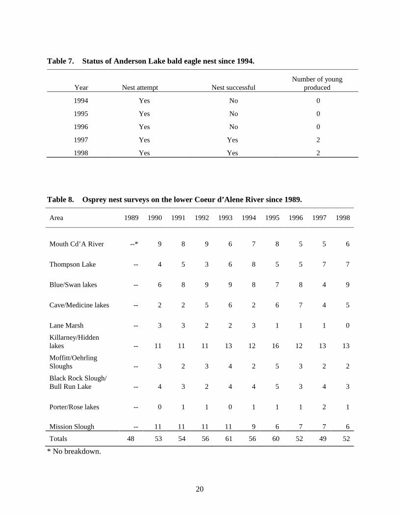
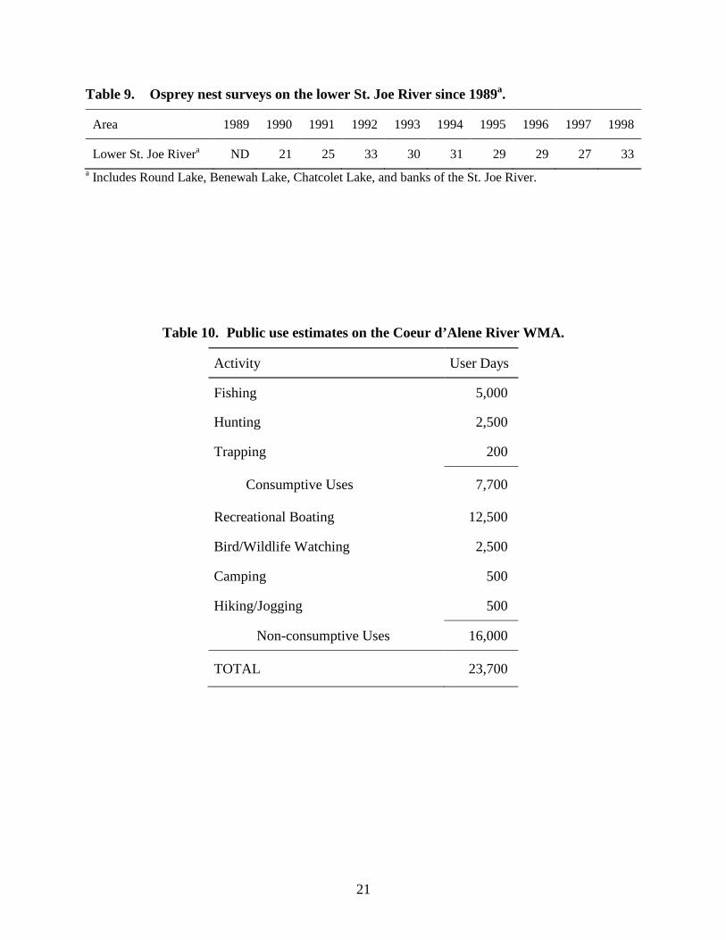
A pair of bald eagles has nested on the WMA near Killarney Lake since 1992. They have successfully fledged young four of the last seven years (Table 6). A second bald eagle nest was discovered in 1994 adjacent to Anderson Lake. This nest has been successful two of the last five years (Table 7). Over 50 pair of osprey nest on the lower Coeur d’Alene River and an additional 30 pair nest near the mouth of the St. Joe River (Tables 8 and 9). Osprey readily nest on a variety of structures including live and dead trees, power poles, pilings, and nesting platforms erected for Canada geese. Other conspicuous non-game birds commonly found on the WMA include great blue herons, red-tailed hawks, northern harriers, American kestrels, Virginia and sora rails, belted kingfishers, common ravens, and northern flickers. A wide variety of other resident and migrant birds utilize the diverse array of habitats found on the WMA.
9
Common non-game mammals include chipmunks, pine squirrels, and Columbian ground squirrels. Seven reptiles and six amphibians are known to inhabit the WMA. The most visible species are the painted turtle, western garter snake, and spotted frog. Fisheries
The lakes and deeper marshes of the lower Coeur d’Alene and St. Joe rivers support good populations of spiny-ray fish species: largemouth bass, black crappie, yellow perch, pumpkinseed sunfish and northern pike. Anderson Lake still holds the state record for largemouth bass, which weighed 10 pounds, 15 ounces. Thompson Lake held the state record for northern pike until 1990, when the record was broken by a pike caught in Cougar Bay on the northern end of Coeur d’Alene Lake. Bullhead catfish are also abundant in the lakes and in the mainstem of the Coeur d’Alene River.
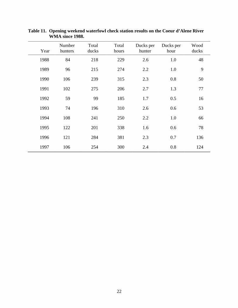
PUBLIC USE Developed access sites are heavily used by the public seeking access to the Coeur d’Alene and St. Joe rivers and associated lakes for fishing, hunting, sight-seeing, bird watching, camping, recreational boating, or other outdoor pursuits. Public use of the WMA is estimated to be 23,700 user days annually (Table 10). The Department maintains boating access sites at Rose Lake, Bull Run Lake, Medimont, Thompson Lake, and Round Lake. Access sites maintained by the Bureau of Land Management and US Forest Service at Killarney Lake and Rainey Hill also provide additional access to the Coeur d’Alene River segment of the WMA. Access sites within Heyburn State Park provide excellent coverage for public use of the lower St. Joe River and adjacent lakes. The greatest use of the WMA boat access facilities is by anglers and recreational boaters followed by waterfowl hunters. Since 1988, an average of 100 waterfowl hunters have been checked during the opening weekend of the duck hunting season at the Killarney Lake and Medimont boat ramps (Table 11).
MANAGEMENT GOALS AND ONGOING ACTIVITIES The following goals have been developed for the Coeur d’Alene River WMA. The goals are responsive to the identified issues, the purposes for which the WMA was originally acquired, and the Department’s 1991-95 Waterfowl Management Plan. 1. Develop and manage wetlands for waterfowl production.
Canada Goose Management:
• Maintain approximately 285 nesting structures annually.
• Replace, relocate and add new nest structures.
10
• Maintain approximately 150 acres of grass pasture to provide secure feeding areas for breeding geese and their broods.
• Maintain share-crop agreement to produce goose pasture and provide hay bales for goose nesting structures.
• Continue annual noxious weed (purple loosestrife) control program.
• Transplant goslings from depredation flocks in other regions of the state.
• Monitor nesting Canada geese through an annual nest census. The goal for the Coeur d’Alene River WMA is 50 nesting pair.
Duck Management:
• Provide and maintain habitat for upland nesting duck species adjacent to wetlands.
• Protect riparian shrub stands preferred by upland nesting ducks for nest sites, primarily pink spirea.
• Maintain approximately 400 nesting boxes for cavity nesting ducks, primarily wood ducks.
• Replace, relocate and add new nest boxes.
• Document duck productivity and total production through annual breeding pair counts and brood counts on four marshes, representative of WMA wetland habitat. The statewide objective is 30 broods per 100 pairs.
• Monitor wood duck nesting success through an annual census of nest boxes.
• Band locally produced ducks as part of the Pacific Flyway’s Banding Program to estimate harvest rate and determine migration routes and wintering habitat.
• Harvest wild rice seed to provide seed source for the Department’s Habitat Improvement Program on private wetlands.
2. Provide wildlife-related recreation, particularly public hunting, fishing and wildlife
observation.
• Maintain access site facilities - parking areas, outdoor restrooms, docks and boat ramps.
• Conduct waterfowl check stations during the opening weekend of the duck hunting season.
• Randomly monitor sportsmen and other WMA visitors for compliance with regulations and hunting/fishing success.
• Maintain 2.5 miles of access roads.
3. Provide wetland and upland habitats for a variety of nongame wildlife species and furbearers.
11
• Maintain dikes and water level control structures to provide stable water levels for aquatic furbearers.
• Maintain secure nesting conditions for bald eagles and ospreys.
• Monitor bald eagle nesting success.
• Monitor nesting ospreys through an annual nest census.
• Conduct timber harvest activities to maintain or improve wildlife habitat.
• Document beneficial use of water rights. 4. Provide habitat for migrating waterfowl.
• Monitor the WMA for waterfowl disease outbreaks.
• Sample gizzards from hunter-harvested ducks for incidence of lead shot and steel shot.
• Maintain dikes and water level control structures to provide higher water levels.
• Document beneficial use of water rights.
• Continue the Thompson Lake waterfowl hunting closure to provide a security area for migrating ducks and geese.
5. Provide habitat for big game and upland game species.
• Maintain share-crop agreement to provide cereal grain and clover pasture on 40 acres as a food source for white-tailed deer, elk, black bear, turkeys, and ruffed grouse.
• Maintain seven miles of boundary fence to exclude unauthorized livestock grazing.
• Continue annual noxious weed control program.
• Seasonally limit motorized access to minimize disturbance or displacement of big game species.
• Conduct timber harvest activities to maintain or improve wildlife habitat.
ISSUES, OBJECTIVES AND STRATEGIES The following management issues were identified jointly by the Department and the public. Objectives and strategies were then developed in an attempt to address these issues while still meeting the goals driving management on the WMA. Wherever possible strategies are quantified to assist the Department and public evaluate plan accomplishments. Issue 1: The spread of noxious weeds has the potential to decrease the quality and quantity of wildlife habitat on the WMA.
12
Objective: The Department will comply with Idaho State law pertaining to the control of noxious weeds.
Strategies: A number of noxious weeds are present on the Coeur d’Alene River WMA including orange hawkweed, spotted knapweed and purple loosestrife. Purple loosestrife is the most significant noxious weed infestation and is found in scattered patches around the lateral lakes and along the lower St. Joe River. Noxious weeds take over sites that could be occupied by desirable vegetation that provides forage and cover for wildlife. Noxious weeds on the WMA may also spread to adjacent ownerships.
Noxious weeds will be either mowed to prevent seed maturation or spot sprayed with herbicide. The Department will avoid those management activities conducive to spreading weeds if possible. The Department will continue participation in an annual joint effort with the Idaho Department of Lands, Kootenai County, and Benewah County to spray purple loosestrife.
During the summer of 1996, the Department initiated a biological control effort to reduce loosestrife by inoculating host plants with root borers that may control loosestrife naturally. The USFS continued biological control efforts on Department property during the summer of 1998. It remains to be seen if this program will be successful.
Issue 2: Some waterfowl hunters believe that a portion of the boundary of the Thompson Lake waterfowl hunting closure should be changed to provide hunting opportunity from the railroad tracks beside Anderson Lake.
Objective: The Department will continue with the current closure boundaries.
Strategies: This closure was created to provide a refuge that would hold waterfowl in the area longer once the hunting season opened. The closure has been successful. Ducks and geese stay in the vicinity longer and provide hunting opportunity throughout the season until freeze up occurs.
The boundaries of the hunting closure were specifically chosen to eliminate a hunter “firing line” to protect waterfowl leaving the closed area in the direction of Anderson Lake. The Department recognizes that the present boundary eliminates the best waterfowl hunting opportunities on Anderson Lake. However, changing the boundary would negate the purpose for creating the closure in the first place.
Painted posts will be placed on the Anderson Lake outlet channel and on the east-end of Anderson Lake to aid hunters with identification of the boundaries.
Issue 3: The entire floodplain of the Coeur d’Alene River is contaminated with water borne mine waste from 100 years of mining activity in the Silver Valley. Heavy metals, principally lead, cadmium and zinc are widespread. Considerable research and debate have taken place to determine what detrimental impacts these metals have on human health, water quality and the welfare of animals and plants that are found in the floodplain. The debate presently revolves
13
around the scope and cost of the cleanup effort and quantifying the extent of injury to the environment.
Objective: Seek consensus on a cleanup plan for the lower Coeur d’Alene River Valley that is acceptable to all major stakeholders and the public.
Strategies: Cleaning up or restoring 10,000 acres of the lower Coeur d’Alene River Valley contaminated with heavy metals to some condition acceptable to everyone will be an enormous task and very expensive. Divergent viewpoints exist over how clean is clean, how much cleanup is necessary and where to do it, what techniques will work, how much will it cost, how long will it take, and who will pay.
The Department will continue to be an active participant in discussions with the State of Idaho, the Coeur d’Alene Indian Tribe, the US Government, and the mining companies to try to seek resolution to a cleanup plan that is acceptable to all parties involved. The Department owns almost half of the floodplain area that is contaminated and has a major stake in the eventual resolution of this issue.
Issue 4: Some members of the public believe that the Department should not be acquiring more land within the floodplain of the Coeur d’Alene River for public recreational access. They contend that this invites human health concerns with user exposure to heavy metals found in sediments that cover the floodplain. Other members of the public believe that the Department should be acquiring additional land for recreational access to meet the growing public demand for sites to fish, hunt, launch boats, and for family day use.
Objective: The Department will continue to acquire suitable sites for public access from willing sellers on a case by case basis.
Strategies: In spite of widespread publicity concerning heavy metal contamination, there has been no evidence that public use of the WMA for outdoor recreation has declined. No public agency responsible for human health has told the public to stay away. Signs have been posted at all public access sites from Cataldo downstream to Harrison warning the public of the potential risks of heavy metals and how to avoid exposure.
Until the cleanup issues are solved, the public will have to be educated and learn to live with the contamination and make their own informed choices.
Existing Department-owned access sites will be upgraded to reduce the exposure of WMA visitors to metal contamination. This will include paving parking areas to cut down blowing dust and mud. Erosion control efforts and vegetative plantings will also be evaluated to reduce exposure pathways.
Issue 5: Wild rice, introduced to Benewah and Kootenai counties by sportsmen and the IDFG from the 1930's-1950's as a waterfowl food crop, is now widespread. In some shallow lakes wild rice is now considered a nuisance by private landowners who are concerned with declining boating opportunities and upland property values.
14
Objective: The Department will no longer transplant wild rice without seeking landowner approval beforehand.
Strategies: The Department will not transplant wild rice at the mouth of the St. Joe River and Round Lake in Benewah County due to landowner concerns. However, the Department will not attempt to prevent wild rice from spreading on its own. The Department recognizes that wild rice can be considered a nuisance by some landowners and boaters. However, it is also a preferred waterfowl food source.
Issue 6: The WMA continues to receive unauthorized livestock grazing each year.
Objective: Eliminate unauthorized grazing on WMA lands.
Strategies: The Department will continue to maintain boundary fences and drift fences annually to exclude unauthorized livestock. The Department will keep in close contact with adjacent landowners to remove unauthorized livestock as soon as possible.
Issue 7: Wakes from power boats and jet skis are contributing to the erosion of the banks of the Coeur d’Alene River resulting in the loss of property and adding to the sediment and heavy metal loads of the river.
Objective: Reduce riverbank erosion from power boat and jet ski wakes.
Strategies: The Department will support the efforts of those government agencies that have the authority to legally address this issue. The Department’s authority extends only to the use of watercraft when used directly in the acts of hunting or fishing.
Issue 8: Litter accumulation and noncompliance with the 10-day camping limit and other regulations are chronic problems at public access sites.
Objective: Improve compliance with regulations at public access sites.
Strategies: The Department will employ a temporary employee to clean access sites and record campers’ vehicle license numbers. Campers in violation of Department regulations will generally be warned once and then cited if violations continue.
Issue 9: Access across Department property to private inholdings can be restricted due to seasonal road closures.
Objective: Provide access to private inholdings as long as such access does not damage established roads nor conflict with WMA wildlife objectives.
Strategies: The Department will continue to cooperate with adjacent landowners to provide road access when necessary. However, the Department will not recognize unlimited public or private access unless it occurs on deeded public roads.

15
The Department presently grants temporary road use licenses to adjacent landowners with no deeded access. Requests for permanent road easements will be considered on a case by case basis.
16
Issue 10: Private landowners often object to increased traffic and dust on public roads from hunters and anglers seeking access to Department property and area lakes.
Objective: Minimize objections of property owners residing along unimproved county roads to public access.
Strategies: The Department does not have jurisdiction over maintenance and improvement of county roads. However, the Department recognizes that increased traffic and dust is a concern and will consider the degree of impacts to property owners when developing future access site improvements.
Issue 11: The use of airboats by some waterfowl hunters to access hunting areas often creates conflicts with adjacent property owners and those hunters that do not use air boats.
Objective: Reduce user conflicts.
Strategies: The Department has limited authority to regulate airboat use. This authority extends only to the use of watercraft when the use is directly related to the acts of hunting and fishing. Efforts to reduce conflicts will require voluntary restraint on the part of airboat users.
Issue 12: Dikes and water control structures designed to provide management of water levels in some wetlands and shallow lakes are barriers to hunters and anglers using motorized watercraft.
Objective: Continue to maintain dikes and water control structures.
Strategies: Dikes and water control structures are necessary to provide water level maintenance through the fall and winter months due to the drawdown of Coeur d’Alene Lake by Post Falls Dam.
Retention of water levels in wetlands provides for greater use by fish, waterfowl and other wetland wildlife. This in turn contributes to greater fishing and hunting opportunity. The benefits that water control structures provide far outweigh the inconveniences they cause to motorized watercraft.
17
Table 1. Ducklings observed during brood counts on the Coeur d’Alene River WMA since 1992.
Ducklings Observed Species 1992 1993 1994 1995 1996 1997 1998
Mallard 112 153 232 136 78 95 141
Wood Duck 38 67 96 22 83 111 69
Green-Winged Teal 22 6 17 4 0 6 0
Other Teal species 0 7 10 0 3 0 0
Redhead 0 0 0 0 0 1 0
TOTAL 172 233 355 162 164 213 210 Table 2. Canada goose goslings transplanted to the Coeur d’Alene River WMA since
1987.
Mo-Year No. Geese
Transplanted Trap Site Release Site June 1987 137 Bear Lake NWR - Reg 5 Coeur d’Alene River WMA
June 1989 116 Reno, NV Coeur d’Alene River WMA
June 1990 151 Klamath Falls, OR Coeur d’Alene River WMA
June 1991 325 Klamath Falls, OR Mission Slough 85 Bull Run Lake 75 Land Marsh 36 Moffitt Slough 129
June 1992 289 Klamath Falls, OR Bull Run Lake 189 Swan Lake 100
June 1993 65 (only 55 banded)
Lewiston - Reg 2 Swan Lake 65
June 1996 75 Lewiston - Reg 2 Swan Lake 75
18
Table 3. Canada goose nests observed on the Coeur d’Alene River WMA since 1989.
Year Round Lake Heyburn Park Swan and
Thompson Lake Rose, Porter and Killarney Lakes Total nests
1989 8 8 14 18 48 1990 10 11 13 22 56 1991 11 8 20 26 65 1992 13 11 16 27 67 1993 14 16 20 38 88 1994 6 17 29 45 97 1995 11 26 32 28 97 1996 8 28 25 33 94 1997 10 24 23 29 86 1998 7 25 20 26 78
Table 4. Wood duck nest box surveys on the Coeur d’Alene River WMA since 1989.
Year Usable boxes
checked Boxes used
(%) Hatched
(%) Abandoned
(%) Destroyed
(%) Still active
(%) 1989 180 81(45%) ND ND ND ND
1990 241 140(58%) ND ND ND ND
1991 257 123(48%) ND ND ND ND
1992 279 79(28%) 15(19%) 23(29%) 41(52%) 0
1993 276 99(36%) 45(45%) 11(11%) 19(19%) 24(24%)
1994 214 91(43%) 71(78%) 5(6%) 7(8%) 8(9%)
1995 216 69(32%) 64(93%) 5(7%) 0 0
1996 250 105(42%) 94(90%) 7(7%) 3(3%) 1(1%)
1997 160 83(52%) 65(78%) 16(19%) 1(1%) 1(1%)
1998 180 83(41%) 57(69%) 17(20%) 9(11%) 0 ND - No data

19
Table 5. Comparison of ingested lead and steel shot in hunter-harvested duck gizzards from the Coeur d’Alene River WMA since 1988.
Year Sample Size Percentage
With Ingested Lead Percentage
With Ingested Steel
1988 103 16.5% 4%
1989 159 14.5% 13%
1990 202 13% 14.5%
1991 198 8.5% 10%
1992 81 4% 11%
1993 189 9% 14%
1994 187 14% 9%
1995 189 13% 10%
1996 230 10% 7%
1997 208 13% 11.5% Table 6. Status of Coeur d’Alene River (Killarney Lake) bald eagle nest since 1992.
Year Nest attempt Nest successful Number of young
produced
1992 Yes No 0
1993 Yes No 0
1994 No -- 0
1995 Yes Yes 2
1996 Yes Yes 1
1997 Yes Yes 2
1998 Yes Yes 2
20
Table 7. Status of Anderson Lake bald eagle nest since 1994.
Year Nest attempt Nest successful Number of young
produced
1994 Yes No 0
1995 Yes No 0
1996 Yes No 0
1997 Yes Yes 2
1998 Yes Yes 2 Table 8. Osprey nest surveys on the lower Coeur d’Alene River since 1989.
Area 1989 1990 1991 1992 1993 1994 1995 1996 1997 1998
Mouth Cd’A River --* 9 8 9 6 7 8 5 5 6
Thompson Lake -- 4 5 3 6 8 5 5 7 7
Blue/Swan lakes -- 6 8 9 9 8 7 8 4 9
Cave/Medicine lakes -- 2 2 5 6 2 6 7 4 5
Lane Marsh -- 3 3 2 2 3 1 1 1 0
Killarney/Hidden lakes -- 11 11 11 13 12 16 12 13 13
Moffitt/Oehrling Sloughs -- 3 2 3 4 2 5 3 2 2
Black Rock Slough/ Bull Run Lake -- 4 3 2 4 4 5 3 4 3
Porter/Rose lakes -- 0 1 1 0 1 1 1 2 1
Mission Slough -- 11 11 11 11 9 6 7 7 6
Totals 48 53 54 56 61 56 60 52 49 52
* No breakdown.
21
Table 9. Osprey nest surveys on the lower St. Joe River since 1989a.
Area 1989 1990 1991 1992 1993 1994 1995 1996 1997 1998
Lower St. Joe Rivera ND 21 25 33 30 31 29 29 27 33 a Includes Round Lake, Benewah Lake, Chatcolet Lake, and banks of the St. Joe River.
Table 10. Public use estimates on the Coeur d’Alene River WMA.
Activity User Days
Fishing 5,000
Hunting 2,500
Trapping 200
Consumptive Uses 7,700
Recreational Boating 12,500
Bird/Wildlife Watching 2,500
Camping 500
Hiking/Jogging 500
Non-consumptive Uses 16,000
TOTAL 23,700
22
Table 11. Opening weekend waterfowl check station results on the Coeur d’Alene River WMA since 1988.
Year Number hunters
Total ducks
Total hours
Ducks per hunter
Ducks per hour
Wood ducks
1988 84 218 229 2.6 1.0 48
1989 96 215 274 2.2 1.0 9
1990 106 239 315 2.3 0.8 50
1991 102 275 206 2.7 1.3 77
1992 59 99 185 1.7 0.5 16
1993 74 196 310 2.6 0.6 53
1994 108 241 250 2.2 1.0 66
1995 122 201 338 1.6 0.6 78
1996 121 284 381 2.3 0.7 136
1997 106 254 300 2.4 0.8 124
23
APPENDIX A LAND AND WATER CONTROL
LAND ACQUISITIONS
COEUR d’ALENE RIVER SEGMENT Year Funds Used Acres Acquired From Kootenai County 1958 DJ 0.67 W. Watson 1961 DJ 29.65 D. Lewis 1964 Gift 363.60 American Game Association 1965 FG 80.00 Raymond Griner 1966 FG 39.95 Papesh Company 1969 PR 542.52 Diamond International 1970 PR 80.00 Addie Belle Bolich 1971 Exchange 566.69 Seattle First National Bank 1971 Exchange 169.00 Joe Farber 1971 PR 125.00 Evan Jones 1971 PR 287.11 Robert and Nancy Kennedy 1972 PR 132.00 Elvier Oehrling 1972 PR 75.42 Chris Weddle 1972 FG 497.87 Mattawa Land and Cattle Company 1972 PR/Exchange 284.45 Robert Kennedy 1972 PR 5.00 Ben Reese 1972 PR 139.50 Leroy McDaniel 1972 PR 33.00 Raymond Chatfield 1972 PR 17.00 Potlatch Forests, Inc. 1972 PR 63.24 Lonnie Soucy 1973 PR 3.87 Idaho Forest Industries, Inc. 1975 PR 5.00 Idaho Forest Industries, Inc. 1975 PR 75.86 Floyd Klein 1975 Gift 20.00 Pat Flammia 1976 PR 332.34 John McHugh, et al. 1976 PR 317.61 Amelia Shaffer 1979 LWCF 59.33 Pat Flammia 1979 FG 160.00 Helen Strobel 1982 Gift 7.00 Lloyd Harding 1982 Gift 62.16 Robert McFarland 1984 FG 153.80 Eugene Neff 1985 FG&DU 62.00 Oehrling Estate 1985 FG&DU 58.00 Shirley Foley 1986 FG 2.70 Florence Farber 1990 FG 80.00 Bert Russell 1992 FG&DU 52.97 Carolyn Lanes, et al. 1993 FG 0.50 Dana Pankey
24
Subtotal CDA River 4984.81 LAND ACQUISITIONS continued
ROUND LAKE SEGMENT
Year Funds Used Acres Acquired From Kootenai County 1995 PR 80.00 Josephine Forrester Benewah County 1954 PR&DJ 156.06 Lucinda Hemenway 1955 PR 71.00 Josephine Forrester 1981 FG 68.90 Potlatch Corporation 1981 FG 128.30 Potlatch Corporation 1993 FG&DU 146.03 Rustin and Tina Young 1993 FG 35.73 Larry and Laureen Belmont Subtotal Round Lake 686.02
TOTAL WMA 5,670.83
COOPERATIVE AGREEMENTS/LEASES COEUR d’ALENE RIVER SEGMENT Year Funds Used Acres Acquired From Kootenai County 1959 None 1.37 Bureau of Land Management 1969 None 434.28 Bureau of Land Management 1973 None 25.50 US Forest Service 1974 None 1.00 US Forest Service 1976 PR&FG 592.36 Idaho Department of Lands (Amended) 1986 None 260.00 US Forest Service 1989 None 80.00 Washington Water Power Company Subtotal CDA River 1,394.51 ROUND LAKE SEGMENT Benewah County 1956 None 249.60 Washington Water Power Company (Amended 1995)
TOTAL WMA 1,644.11
25
WATER RIGHTS
COEUR d’ALENE RIVER SEGMENT
License Number Priority Date Storage License Issued Name
Kootenai County 94-7082 7/14/76 907 af 11/21/89 Blessing Slough 94-7100 4/29/77 95 af 7/30/79 Seivert Marsh 94-7102 6/15/77 220 af 4/17/84 Porter Lake 94-7129 12/1/78 185 af 1/24/86 Hidden Island Marsh 94-7170 6/15/80 255 af 1/10/86 Strobel Marsh 94-7181 9/24/80 2,640 af 1/24/86 Swan Lake 94-7220 8/29/82 360 af 11/18/87 Killarney Dike 94-7294 9/22/85 347 af 11/16/93 Moffitt Slough 95-4411 5/1/71 510 af Pending Bare Marsh 95-7961 8/10/79 200 af 4/27/90 Thompson Marsh
TOTAL WMA 5,719 af
26
APPENDIX B
DEVELOPMENT HISTORY 1971 Water control structure replaced at outlet of Bare Marsh.
1973 Headquarters residence completed.
1974 Office-shop-storage building completed.
1975 Parking area and boat ramp developed at the Thompson Lake outlet channel.
1975 Boat ramps and rest rooms developed under cooperative agreements with the US Forest Service and Bureau of Land Management at Medimont and Killarney Lake access sites.
1975-1985 Dikes and water level control structures developed.
1981 Dike and water control structure constructed in west arm of Thompson Lake.
1982-1984 Several hundred small islands with interconnecting channels constructed using hydraulic excavators on log mats in Strobel, Campbell and Moffitt Sloughs, near Killarney Lake and Lane Marsh.
1983-1984 Eighty pilings driven in marshlands for goose-nesting structures.
1984 Rose Lake marsh enhancement removed dead and decadent willow and alder clumps to create open water areas.
1989-1990 Oehrling Slough Salvage timber sale. Fourteen acres treated to salvage 24,300 board feet.
1989-1991 Installed two handicapped accessible toilets at Rose Lake access.
1990-1991 Timber sale contract let for 67,560 board feet at Round Lake to salvage ponderosa pine dying from bark beetle attack. Seventy acres treated.
1992-1993 Round Lake Salvage timber sale. Continued salvage of ponderosa pine dying from bark beetles. Sixty acres treated to salvage 159,850 board feet.
1992-1993 Thompson Lake Salvage timber sale. Salvaged ponderosa pine dying from bark beetles. Fifteen acres treated to salvage 77,440 board feet.
1993-1994 Developed new access site at Round Lake. Constructed new access road, parking lot, handicapped accessible toilet, and concrete boat ramp.
1993-1994 Thompson Lake Salvage II. Ten acres treated to salvage 78,050 board feet.
1995-1996 Thompson Lake Salvage III. Twenty-five acres treated to salvage 75,000 board feet.
27
1996-1997 Coeur d’Alene River Salvage timber sale. Seven acres treated to salvage 27,260 board feet.
1997 Dikes and water control structures repaired at lower Blessing Slough, Thompson Lake and Swan Lake outlet that were damaged from flooding in 1996.
1997-1998 Replaced 100 free standing goose platforms lost due to flooding in 1996 and 1997.
1998 Replaced 80 piling nest platforms lost due to flooding in 1996 and 1997.